Bridge Statistics for Oakley, California (CA)
Condition, Traffic, Stress, Structural Evaluation, Project Costs
- National Bridge Inventory (NBI) Statistics
- 18Number of bridges
- 223ft / 68.1mTotal length
- $470,000Total costs
- 74,461Total average daily traffic
- 9,399Total average daily truck traffic
- National Bridge Inventory (NBI) Registered Bridges for Oakley
- No street view available for this location
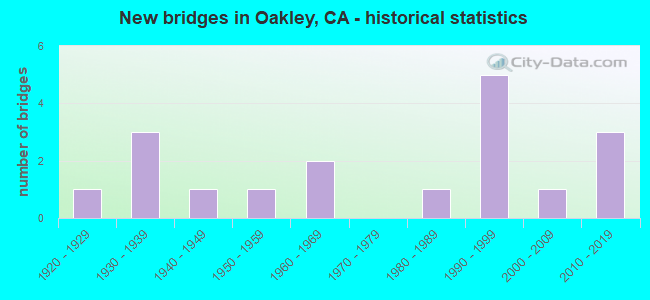
- New bridges - historical statistics
- 11920-1929
- 31930-1939
- 11940-1949
- 11950-1959
- 21960-1969
- 11980-1989
- 51990-1999
- 12000-2009
- 32010-2019
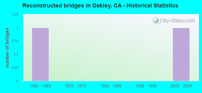
- Reconstructed bridges - Historical Statistics
- 11960-1969
- 01970-1979
- 01980-1989
- 01990-1999
- 12000-2009
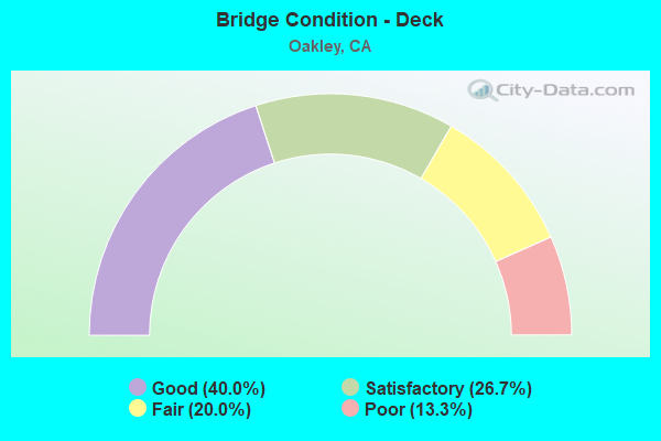
- Bridge Condition - Deck
- 40.0%Good
- 26.7%Satisfactory
- 20.0%Fair
- 13.3%Poor
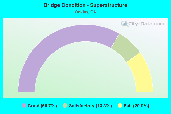
- Bridge Condition - Superstructure
- 66.7%Good
- 13.3%Satisfactory
- 20.0%Fair
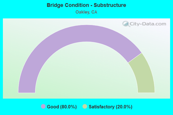
- Bridge Condition - Substructure
- 80.0%Good
- 20.0%Satisfactory
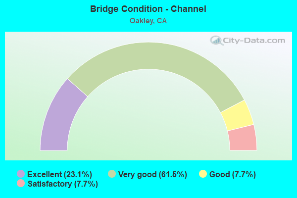
- Bridge Condition - Channel
- 23.1%Excellent
- 61.5%Very good
- 7.7%Good
- 7.7%Satisfactory
Find on map >> Show street view
Structure Number: 28C0125, Location: 0.3 MI N Alameda CL (Lat: 37.812400, Lng: -121.578500), Route carried "on" structure: County highway , Year Built: 1953, Status: Open, Structure Length: 1.31m (4.30ft), Average Daily Traffic: 6,500 (year 2020), Truck Traffic: 12%, Average Future Daily Traffic: 12,780 (year 2034), Design Load: HS 20, Features Intersected: Delta-Mendota Canal, Facility Carried by Structure: Byron Highway
Minimum Vertical Clearance: 30+ m (98+ ft), Kilometerpoint: 2.188, Lanes on structure: 2, Owner: Bureau of Reclamation, Approaching Roadway Width: 9.1m (29.9ft), Material/Design: Concrete continuous, Design/Construction: Culvert, Number Of Spans In Main Unit: 3, Length of Maximum Span: 4.6m (15.1ft)
Condition: Channel: Very good, Culverts: Good, Operating Rating: 54.1 metric tons, Method Used To Determine Operating Rating: Field evaluation and documented engineering judgment, Inventory Rating: 32.4 metric tons, Method Used To Determine Inventory Rating: Field evaluation and documented engineering judgment, Structural Evaluation: Better than present minimum criteria, Waterway Adequacy: Better than present minimum criteria, Approach Roadway Alignment: Equal to present desirable criteria, Designated Inspection Frequency: Every 48 months, Underwater Inspection Frequency: Every 60 months, Inspection Date: Febuary 2020, Underwater Inspection Date: Febuary 2020
Find on map >> Show street view
Structure Number: 28C0129, Location: 0.05 MI EAST OF SR 4 (Lat: 37.990581, Lng: -121.696242), Route carried "on" structure: County highway , Year Built: 1964, Year Reconstructed: 2006, Status: Open, Structure Length: 2.38m (7.81ft), Average Daily Traffic: 9,415 (year 2009), Truck Traffic: 20%, Average Future Daily Traffic: 16,520 (year 2041), Design Load: HS 20, Features Intersected: MARSH CREEK, Facility Carried by Structure: CYPRESS ROAD
Minimum Vertical Clearance: 30+ m (98+ ft), Kilometerpoint: 0.000, Lanes on structure: 5, Owner: City or Municipal Highway Agency, Approaching Roadway Width: 26.8m (87.9ft), Skew: 33 degrees, Material/Design: Prestressed concrete, Design/Construction: Stringer/Multi-beam, Number Of Spans In Main Unit: 1, Length of Maximum Span: 23.1m (75.8ft), Curb or Sidewalk Widths: Left: 0.0m, Right: 1.5m (4.9ft), Curb-To-Curb Width: 23.2m (76.1ft), Out-to-Out Width: 26.7m (87.6ft)
Condition: Deck: Poor, Superstructure: Good, Substructure: Good, Channel: Good, Operating Rating: 45.0 metric tons, Method Used To Determine Operating Rating: Load and Resistance Factor Rating (LRFR) rating reported by rating factor(RF) method using HL-93 loadings, Inventory Rating: 33.7 metric tons, Method Used To Determine Inventory Rating: Load and Resistance Factor Rating (LRFR) rating reported by rating factor(RF) method using HL-93 loadings, Structural Evaluation: Better than present minimum criteria, Deck Geometry: Better than present minimum criteria, Waterway Adequacy: Better than present minimum criteria, Approach Roadway Alignment: Equal to present minimum criteria, Designated Inspection Frequency: Every 24 months, Inspection Date: January 2021, Deck Structure Type: Concrete Cast-file-Place
Find on map >> Show street view
Structure Number: 28C0171, Location: 0.3 MI N PORT CHICAGO HY (Lat: 38.045083, Lng: -121.987986), Route carried "on" structure: County highway , Year Built: 1991, Status: Open, Structure Length: 2.96m (9.71ft), Average Daily Traffic: 485 (year 2013), Truck Traffic: 40%, Average Future Daily Traffic: 640 (year 2037), Design Load: HS 20+Mod, Features Intersected: UP RR, BNSF RY, & AMTRAK, Facility Carried by Structure: NICHOLS RD
Minimum Vertical Clearance: 30+ m (98+ ft), Kilometerpoint: 0.000, Lanes on structure: 2, Owner: County Highway Agency, Approaching Roadway Width: 9.8m (32.2ft), Material/Design: Prestressed concrete continuous, Design/Construction: Slab, Number Of Spans In Main Unit: 3, Length of Maximum Span: 12.8m (42.0ft), Curb-To-Curb Width: 8.5m (27.9ft), Out-to-Out Width: 9.6m (31.5ft)
Condition: Deck: Good, Superstructure: Good, Substructure: Good, Operating Rating: 54.1 metric tons, Method Used To Determine Operating Rating: Assigned rating based on Load Factor Design (LFD) reported in metric tons, Inventory Rating: 32.4 metric tons, Method Used To Determine Inventory Rating: Assigned rating based on Load Factor Design (LFD) reported in metric tons, Structural Evaluation: Better than present minimum criteria, Deck Geometry: Somewhat better than minimum adequacy, Underclear: Meets minimum limits, Approach Roadway Alignment: Equal to present minimum criteria, Designated Inspection Frequency: Every 24 months, Inspection Date: November 2020, Deck Structure Type: Concrete Cast-file-Place
Find on map >> Show street view
Structure Number: 28C0202, Location: 0.4 MI E CAMINO TASSAJARA (Lat: 37.786806, Lng: -121.859425), Route carried "on" structure: County highway , Year Built: 1998, Status: Open, Structure Length: 2.21m (7.25ft), Average Daily Traffic: 644 (year 2013), Truck Traffic: 2%, Average Future Daily Traffic: 1,220 (year 2036), Design Load: HS 20+Mod, Features Intersected: TASSAJARA CREEK, Facility Carried by Structure: JOHNSTON ROAD
Minimum Vertical Clearance: 30+ m (98+ ft), Kilometerpoint: 0.000, Lanes on structure: 2, Owner: County Highway Agency, Approaching Roadway Width: 10.4m (34.1ft), Skew: 2 degrees, Material/Design: Concrete, Design/Construction: Box Beam or Girders - Multiple, Number Of Spans In Main Unit: 1, Length of Maximum Span: 20.7m (67.9ft), Curb-To-Curb Width: 10.4m (34.1ft), Out-to-Out Width: 11.4m (37.4ft)
Condition: Deck: Satisfactory, Superstructure: Satisfactory, Substructure: Good, Channel: Very good, Operating Rating: 54.1 metric tons, Method Used To Determine Operating Rating: Assigned rating based on Load Factor Design (LFD) reported in metric tons, Inventory Rating: 32.4 metric tons, Method Used To Determine Inventory Rating: Assigned rating based on Load Factor Design (LFD) reported in metric tons, Structural Evaluation: Equal to present minimum criteria, Deck Geometry: Equal to present minimum criteria, Waterway Adequacy: Superior to present desirable criteria, Approach Roadway Alignment: Better than present minimum criteria, Designated Inspection Frequency: Every 48 months, Inspection Date: November 2018, Deck Structure Type: Concrete Cast-file-Place
Find on map >> Show street view
Structure Number: 28C0206, Location: 0.06 MI W ROSE AVE (Lat: 37.990564, Lng: -121.706181), Route carried "on" structure: County highway , Year Built: 1938, Status: Open, Structure Length: 1.28m (4.20ft), Average Daily Traffic: 6,167 (year 2009), Truck Traffic: 18%, Average Future Daily Traffic: 14,914 (year 2041), Features Intersected: CONTRA COSTA CANAL, Facility Carried by Structure: W. CYPRESS RD
Minimum Vertical Clearance: 30+ m (98+ ft), Kilometerpoint: 0.000, Lanes on structure: 2, Owner: City or Municipal Highway Agency, Approaching Roadway Width: 5.8m (19.0ft), Skew: 5 degrees, Material/Design: Concrete, Design/Construction: Tee Beam, Number Of Spans In Main Unit: 1, Length of Maximum Span: 12.5m (41.0ft), Curb or Sidewalk Widths: Left: 0.3m (1.0ft), Right: 0.3m (1.0ft), Curb-To-Curb Width: 7.3m (24.0ft), Out-to-Out Width: 8.5m (27.9ft)
Condition: Deck: Good, Superstructure: Good, Substructure: Good, Channel: Very good, Operating Rating: 24.9 metric tons, Method Used To Determine Operating Rating: Field evaluation and documented engineering judgment, Inventory Rating: 14.9 metric tons, Method Used To Determine Inventory Rating: Field evaluation and documented engineering judgment, Structural Evaluation: High priority of corrective action, Deck Geometry: High priority of replacement, Waterway Adequacy: Equal to present desirable criteria, Approach Roadway Alignment: Equal to present desirable criteria, Designated Inspection Frequency: Every 24 months, Inspection Date: January 2021, Deck Structure Type: Concrete Cast-file-Place, Wearing Surface/Protective System: Wearing Surface: Bituminous
Find on map >> Show street view
Structure Number: 28C0209, Location: 0.01 MI N LAUREL RD (Lat: 37.983333, Lng: -121.732311), Route carried "on" structure: County highway , Year Built: 1994, Status: Open, Structure Length: 1.48m (4.86ft), Average Daily Traffic: 14,901 (year 2009), Truck Traffic: 15%, Average Future Daily Traffic: 12,937 (year 2041), Features Intersected: CONTRA COSTA CANAL, Facility Carried by Structure: EMPIRE AVE
Minimum Vertical Clearance: 30+ m (98+ ft), Kilometerpoint: 0.000, Lanes on structure: 5, Owner: City or Municipal Highway Agency, Approaching Roadway Width: 20.1m (65.9ft), Skew: 30 degrees, Material/Design: Prestressed concrete, Design/Construction: Slab, Number Of Spans In Main Unit: 1, Length of Maximum Span: 14.8m (48.6ft), Curb or Sidewalk Widths: Left: 2.7m (8.9ft), Right: 2.7m (8.9ft), Curb-To-Curb Width: 21.9m (71.9ft), Out-to-Out Width: 29.3m (96.1ft)
Condition: Deck: Good, Superstructure: Good, Substructure: Good, Channel: Very good, Operating Rating: 54.1 metric tons, Method Used To Determine Operating Rating: Field evaluation and documented engineering judgment, Inventory Rating: 32.4 metric tons, Method Used To Determine Inventory Rating: Field evaluation and documented engineering judgment, Structural Evaluation: Better than present minimum criteria, Deck Geometry: Somewhat better than minimum adequacy, Waterway Adequacy: Equal to present desirable criteria, Approach Roadway Alignment: Equal to present minimum criteria, Designated Inspection Frequency: Every 24 months, Inspection Date: January 2021, Deck Structure Type: Concrete Cast-file-Place, Wearing Surface/Protective System: Wearing Surface: Bituminous
Find on map >> Show street view
Structure Number: 28C0211, Location: 0.8 MI E OF SH4 (Lat: 37.968808, Lng: -121.682736), Route carried "on" structure: County highway , Year Built: 1965, Status: Open, Structure Length: 1.77m (5.81ft), Average Daily Traffic: 4,147 (year 2009), Truck Traffic: 5%, Average Future Daily Traffic: 2,744 (year 2041), Features Intersected: MARSH CREEK, Facility Carried by Structure: DELTA ROAD
Minimum Vertical Clearance: 30+ m (98+ ft), Kilometerpoint: 0.000, Lanes on structure: 2, Owner: City or Municipal Highway Agency, Approaching Roadway Width: 12.2m (40.0ft), Material/Design: Concrete, Design/Construction: Tee Beam, Number Of Spans In Main Unit: 1, Length of Maximum Span: 16.2m (53.1ft), Curb or Sidewalk Widths: Left: 1.5m (4.9ft), Right: 1.5m (4.9ft), Curb-To-Curb Width: 12.2m (40.0ft), Out-to-Out Width: 15.8m (51.8ft)
Condition: Deck: Poor, Superstructure: Good, Substructure: Good, Channel: Satisfactory, Operating Rating: 28.2 metric tons, Method Used To Determine Operating Rating: Field evaluation and documented engineering judgment, Inventory Rating: 16.8 metric tons, Method Used To Determine Inventory Rating: Field evaluation and documented engineering judgment, Structural Evaluation: Meets minimum limits, Deck Geometry: Equal to present minimum criteria, Waterway Adequacy: Equal to present desirable criteria, Approach Roadway Alignment: Better than present minimum criteria, Length Of Structure Improvement: 1.77m (5.81ft), Designated Inspection Frequency: Every 24 months, Inspection Date: January 2021, Bridge Improvement Cost: $280,000, Roadway Improvement Cost: $56,000, Total Project Cost: $470,000 ( Estimate for 2020), Deck Structure Type: Concrete Cast-file-Place
Find on map >> Show street view
Structure Number: 28C0262, Location: 2 MI. E. OF BYRON HWY (Lat: 37.939117, Lng: -121.610453), Route carried "on" structure: County highway , Year Built: 2016, Status: Open, Structure Length: 6.53m (21.42ft), Average Daily Traffic: 1,164 (year 2013), Truck Traffic: 8%, Average Future Daily Traffic: 3,000 (year 2035), Features Intersected: WERNER DREDGER CUT, Facility Carried by Structure: ORWOOD ROAD
Minimum Vertical Clearance: 30+ m (98+ ft), Kilometerpoint: 0.000, Lanes on structure: 2, Owner: County Highway Agency, Approaching Roadway Width: 9.3m (30.5ft), Skew: 1 degrees, Material/Design: Prestressed concrete continuous, Design/Construction: Slab, Number Of Spans In Main Unit: 3, Length of Maximum Span: 21.4m (70.2ft), Curb or Sidewalk Widths: Left: 0.0m, Right: 2.5m (8.2ft), Curb-To-Curb Width: 9.3m (30.5ft), Out-to-Out Width: 13.1m (43.0ft)
Condition: Deck: Good, Superstructure: Good, Substructure: Good, Channel: Very good, Operating Rating: 54.1 metric tons, Method Used To Determine Operating Rating: Field evaluation and documented engineering judgment, Inventory Rating: 32.4 metric tons, Method Used To Determine Inventory Rating: Field evaluation and documented engineering judgment, Structural Evaluation: Better than present minimum criteria, Deck Geometry: Somewhat better than minimum adequacy, Waterway Adequacy: Equal to present desirable criteria, Approach Roadway Alignment: Equal to present desirable criteria, Designated Inspection Frequency: Every 48 months, Underwater Inspection Frequency: Every 60 months, Inspection Date: July 2018, Underwater Inspection Date: May 2020, Deck Structure Type: Concrete Cast-file-Place, Wearing Surface/Protective System: Wearing Surface: Integral Concrete
Find on map >> Show street view
Structure Number: 28C0266, Location: 160 M NE MAIN ST/SR-4 (Lat: 37.986794, Lng: -121.693944), Route carried "on" structure: City street , Year Built: 2003, Status: Open, Structure Length: 2.96m (9.71ft), Average Daily Traffic: 4,200 (year 2009), Truck Traffic: 5%, Average Future Daily Traffic: 2,828 (year 2043), Design Load: HS 20+Mod, Features Intersected: MARSH CREEK, Facility Carried by Structure: BERNARD ROAD
Minimum Vertical Clearance: 30+ m (98+ ft), Kilometerpoint: 0.000, Lanes on structure: 2, Owner: City or Municipal Highway Agency, Approaching Roadway Width: 12.0m (39.4ft), Skew: 1 degrees, Material/Design: Steel, Design/Construction: Stringer/Multi-beam, Number Of Spans In Main Unit: 1, Length of Maximum Span: 29.6m (97.1ft), Curb or Sidewalk Widths: Left: 1.6m (5.2ft), Right: 1.6m (5.2ft), Curb-To-Curb Width: 12.0m (39.4ft), Out-to-Out Width: 15.8m (51.8ft)
Condition: Deck: Good, Superstructure: Good, Substructure: Good, Channel: Very good, Operating Rating: 98.5 metric tons, Method Used To Determine Operating Rating: Load Factor (LF), Inventory Rating: 59.0 metric tons, Method Used To Determine Inventory Rating: Load Factor (LF), Structural Evaluation: Better than present minimum criteria, Deck Geometry: Somewhat better than minimum adequacy, Waterway Adequacy: Equal to present desirable criteria, Approach Roadway Alignment: Equal to present desirable criteria, Designated Inspection Frequency: Every 48 months, Inspection Date: January 2021, Deck Structure Type: Concrete Cast-file-Place
Find on map >> Show street view
Structure Number: 28C0267, Location: 488 M. E. MAIN ST./SR-4 (Lat: 37.983322, Lng: -121.690133), Route carried "on" structure: City street , Year Built: 1990, Status: Open, Structure Length: 2.61m (8.56ft), Average Daily Traffic: 4,200 (year 2009), Truck Traffic: 5%, Average Future Daily Traffic: 2,810 (year 2041), Features Intersected: MARSH CREEK, Facility Carried by Structure: LAUREL ROAD
Minimum Vertical Clearance: 30+ m (98+ ft), Kilometerpoint: 0.000, Lanes on structure: 2, Owner: City or Municipal Highway Agency, Approaching Roadway Width: 9.6m (31.5ft), Skew: 2 degrees, Material/Design: Concrete, Design/Construction: Box Beam or Girders - Multiple, Number Of Spans In Main Unit: 1, Length of Maximum Span: 26.1m (85.6ft), Curb or Sidewalk Widths: Left: 0.9m (3.0ft), Right: 0.0m, Curb-To-Curb Width: 9.6m (31.5ft), Out-to-Out Width: 11.1m (36.4ft)
Condition: Deck: Fair, Superstructure: Good, Substructure: Good, Channel: Very good, Operating Rating: 54.1 metric tons, Method Used To Determine Operating Rating: Field evaluation and documented engineering judgment, Inventory Rating: 32.4 metric tons, Method Used To Determine Inventory Rating: Field evaluation and documented engineering judgment, Structural Evaluation: Better than present minimum criteria, Deck Geometry: Meets minimum limits, Waterway Adequacy: Equal to present desirable criteria, Approach Roadway Alignment: Equal to present desirable criteria, Designated Inspection Frequency: Every 24 months, Inspection Date: January 2021, Deck Structure Type: Concrete Cast-file-Place
Find on map >> Show street view
Structure Number: 28C0268, Location: 0.2MI NE JCT SR-4 (Lat: 37.980600, Lng: -121.741233), Route carried "on" structure: City street , Year Built: 2010, Status: Open, Structure Length: 10.30m (33.79ft), Average Daily Traffic: 4,200 (year 2009), Truck Traffic: 5%, Average Future Daily Traffic: 2,810 (year 2041), Features Intersected: RR/NEROLY ROAD, Facility Carried by Structure: LAUREL ROAD
Minimum Vertical Clearance: 30+ m (98+ ft), Kilometerpoint: 0.000, Lanes on structure: 6, Lanes under structure: 2, Owner: City or Municipal Highway Agency, Approaching Roadway Width: 30.3m (99.4ft), Skew: 30 degrees, Material/Design: Prestressed concrete continuous, Design/Construction: Box Beam or Girders - Multiple, Number Of Spans In Main Unit: 2, Length of Maximum Span: 51.4m (168.6ft), Curb or Sidewalk Widths: Left: 1.5m (4.9ft), Right: 1.5m (4.9ft), Curb-To-Curb Width: 30.3m (99.4ft), Out-to-Out Width: 34.9m (114.5ft)
Condition: Deck: Fair, Superstructure: Good, Substructure: Good, Operating Rating: 54.1 metric tons, Method Used To Determine Operating Rating: Field evaluation and documented engineering judgment, Inventory Rating: 32.4 metric tons, Method Used To Determine Inventory Rating: Field evaluation and documented engineering judgment, Structural Evaluation: Better than present minimum criteria, Deck Geometry: Superior to present desirable criteria, Underclear: Equal to present minimum criteria, Approach Roadway Alignment: Equal to present desirable criteria, Designated Inspection Frequency: Every 24 months, Inspection Date: January 2021, Deck Structure Type: Concrete Cast-file-Place
Find on map >> Show street view
Structure Number: 28C0405, Location: 1.5 MILES N OF CYPRESS RD (Lat: 38.011953, Lng: -121.660614), Route carried "on" structure: County highway , Year Built: 1949, Year Reconstructed: 1967, Status: Open, Structure Length: 19.20m (62.99ft), Average Daily Traffic: 188 (year 2013), Truck Traffic: 24%, Average Future Daily Traffic: 400 (year 2037), Design Load: H 20, Features Intersected: DUTCH SLOUGH, Facility Carried by Structure: JERSEY ISLAND RD
Minimum Vertical Clearance: 30+ m (98+ ft), Kilometerpoint: 0.000, Lanes on structure: 2, Owner: County Highway Agency, Approaching Roadway Width: 6.7m (22.0ft), Material/Design: Wood or Timber, Design/Construction: Stringer/Multi-beam, Number Of Spans In Main Unit: 32, Length of Maximum Span: 12.6m (41.3ft), Curb or Sidewalk Widths: Left: 0.6m (2.0ft), Right: 0.6m (2.0ft), Curb-To-Curb Width: 6.7m (22.0ft), Out-to-Out Width: 7.9m (25.9ft)
Condition: Deck: Satisfactory, Superstructure: Fair, Substructure: Satisfactory, Channel: Excellent, Operating Rating: 40.5 metric tons, Method Used To Determine Operating Rating: Allowable Stress (AS), Inventory Rating: 24.3 metric tons, Method Used To Determine Inventory Rating: Allowable Stress (AS), Structural Evaluation: Somewhat better than minimum adequacy, Deck Geometry: Meets minimum limits, Waterway Adequacy: Equal to present desirable criteria, Approach Roadway Alignment: Somewhat better than minimum adequacy, Designated Inspection Frequency: Every 24 months, Critical Feature Inspection Frequency: Every 24 months, Underwater Inspection Frequency: Every 60 months, Inspection Date: July 2020, Critical Feature Inspection Date: July 2020, Underwater Inspection Date: July 2018, Deck Structure Type: Concrete Cast-file-Place
Find on map >> Show street view
Structure Number: 28C0452, Location: 0.1 MI SE DOUGHERTY RD (Lat: 37.787389, Lng: -121.924011), Route carried "on" structure: City street , Year Built: 1990, Status: Open, Structure Length: 3.66m (12.01ft), Average Daily Traffic: 400 (year 2011), Truck Traffic: 1%, Average Future Daily Traffic: 1,200 (year 2040), Design Load: HS 20, Features Intersected: WEST BRANCH ALAMO CREEK, Facility Carried by Structure: RED WILLOW RD
Minimum Vertical Clearance: 30+ m (98+ ft), Kilometerpoint: 0.000, Lanes on structure: 2, Owner: City or Municipal Highway Agency, Approaching Roadway Width: 7.3m (24.0ft), Material/Design: Wood or Timber, Design/Construction: Stringer/Multi-beam, Number Of Spans In Main Unit: 3, Length of Maximum Span: 12.2m (40.0ft), Curb or Sidewalk Widths: Left: 1.1m (3.6ft), Right: 0.0m, Curb-To-Curb Width: 7.3m (24.0ft), Out-to-Out Width: 9.5m (31.2ft)
Condition: Deck: Good, Superstructure: Satisfactory, Substructure: Good, Channel: Very good, Operating Rating: 44.7 metric tons, Method Used To Determine Operating Rating: Allowable Stress (AS), Inventory Rating: 30.8 metric tons, Method Used To Determine Inventory Rating: Allowable Stress (AS), Structural Evaluation: Equal to present minimum criteria, Deck Geometry: Somewhat better than minimum adequacy, Waterway Adequacy: Equal to present desirable criteria, Approach Roadway Alignment: Equal to present minimum criteria, Designated Inspection Frequency: Every 24 months, Inspection Date: March 2020, Deck Structure Type: Wood or Timber, Wearing Surface/Protective System: Wearing Surface: Bituminous
Find on map >> Show street view
Structure Number: 28C0459, Location: 0.1 MI N OF SH 4 (Lat: 38.000039, Lng: -121.719017), Route carried "on" structure: County highway , Year Built: 1988, Status: Open, Structure Length: 5.49m (18.01ft), Average Daily Traffic: 6,177 (year 2009), Truck Traffic: 5%, Average Future Daily Traffic: 3,868 (year 2043), Design Load: HS 20+Mod, Features Intersected: BNSF RY & AMTRAK, Facility Carried by Structure: VINTAGE PARKWAY
Minimum Vertical Clearance: 30+ m (98+ ft), Kilometerpoint: 0.000, Lanes on structure: 2, Owner: City or Municipal Highway Agency, Approaching Roadway Width: 9.8m (32.2ft), Skew: 2 degrees, Material/Design: Prestressed concrete continuous, Design/Construction: Stringer/Multi-beam, Number Of Spans In Main Unit: 3, Length of Maximum Span: 20.7m (67.9ft), Curb or Sidewalk Widths: Left: 0.0m, Right: 3.4m (11.2ft), Curb-To-Curb Width: 9.9m (32.5ft), Out-to-Out Width: 14.7m (48.2ft)
Condition: Deck: Fair, Superstructure: Good, Substructure: Good, Operating Rating: 54.1 metric tons, Method Used To Determine Operating Rating: Assigned rating based on Load Factor Design (LFD) reported in metric tons, Inventory Rating: 32.4 metric tons, Method Used To Determine Inventory Rating: Assigned rating based on Load Factor Design (LFD) reported in metric tons, Structural Evaluation: Better than present minimum criteria, Deck Geometry: Meets minimum limits, Underclear: Meets minimum limits, Approach Roadway Alignment: Equal to present minimum criteria, Designated Inspection Frequency: Every 24 months, Inspection Date: January 2021, Deck Structure Type: Concrete Cast-file-Place
Find on map >> Show street view
Structure Number: 300-0048-4, Location: 6 m NE of Parker, AZ (Lat: 34.296472, Lng: -114.139528), Route carried "on" structure: ServiceOther road , Year Built: 1934, Status: Posted for load, Structure Length: 2.00m (6.56ft), Average Daily Traffic: 360 (year 2012), Average Future Daily Traffic: 500 (year 2035), Design Load: HS 20, Features Intersected: Colorado River, Facility Carried by Structure: Parker Dam Road
Minimum Vertical Clearance: 30+ m (98+ ft), Kilometerpoint: 0.000, Lanes on structure: 2, Owner: Bureau of Reclamation, Approaching Roadway Width: 7.2m (23.6ft), Material/Design: Concrete, Design/Construction: Girder and Floorbeam System, Number Of Spans In Main Unit: 1, Length of Maximum Span: 15.2m (49.9ft), Curb or Sidewalk Widths: Left: 0.4m (1.3ft), Right: 1.2m (3.9ft), Curb-To-Curb Width: 5.5m (18.0ft), Out-to-Out Width: 7.5m (24.6ft)
Condition: Deck: Satisfactory, Superstructure: Fair, Substructure: Satisfactory, Channel: Excellent, Operating Rating: 53.9 metric tons, Method Used To Determine Operating Rating: Load Factor (LF), Inventory Rating: 32.3 metric tons, Method Used To Determine Inventory Rating: Load Factor (LF), Structural Evaluation: Somewhat better than minimum adequacy, Deck Geometry: High priority of corrective action, Waterway Adequacy: Superior to present desirable criteria, Approach Roadway Alignment: Equal to present minimum criteria, Designated Inspection Frequency: Every 24 months, Inspection Date: December 2020, Deck Structure Type: Concrete Cast-file-Place
Find on map >> Show street view
Structure Number: 300-0048-5, Location: 6 m NE of Parker, AZ (Lat: 34.296472, Lng: -114.139833), Route carried "on" structure: ServiceOther road , Year Built: 1934, Status: Posted for load, Structure Length: 2.00m (6.56ft), Average Daily Traffic: 360 (year 2012), Average Future Daily Traffic: 600 (year 2034), Design Load: HS 20, Features Intersected: Colorado River, Facility Carried by Structure: Parker Dam Road
Minimum Vertical Clearance: 30+ m (98+ ft), Kilometerpoint: 0.000, Lanes on structure: 2, Owner: Bureau of Reclamation, Approaching Roadway Width: 7.2m (23.6ft), Material/Design: Concrete, Design/Construction: Girder and Floorbeam System, Number Of Spans In Main Unit: 1, Length of Maximum Span: 15.2m (49.9ft), Curb or Sidewalk Widths: Left: 0.4m (1.3ft), Right: 1.2m (3.9ft), Curb-To-Curb Width: 5.5m (18.0ft), Out-to-Out Width: 7.5m (24.6ft)
Condition: Deck: Satisfactory, Superstructure: Fair, Substructure: Satisfactory, Channel: Excellent, Operating Rating: 53.9 metric tons, Method Used To Determine Operating Rating: Load Factor (LF), Inventory Rating: 32.3 metric tons, Method Used To Determine Inventory Rating: Load Factor (LF), Structural Evaluation: Somewhat better than minimum adequacy, Deck Geometry: High priority of corrective action, Waterway Adequacy: Superior to present desirable criteria, Approach Roadway Alignment: Equal to present minimum criteria, Designated Inspection Frequency: Every 24 months, Inspection Date: December 2020, Deck Structure Type: Concrete Cast-file-Place
Find on map >> Show street view
Structure Number: 28C0176, Location: 0.4 MI N OF SR 84 (Lat: 38.008969, Lng: -121.750906), Route carried "under" structure: County highway , Year Built: 1926, Structure Length: 0. m, Average Daily Traffic: 6,753 (year 2009), Truck Traffic: 25%, Features Intersected: BRIDGEHEAD ROAD, Facility Carried by Structure: BNSF,UP RR,AMTRAK
Minimum Vertical Clearance: 4.48m (14.70ft), Kilometerpoint: 0.000, Lanes under structure: 2, Material/Design: Steel, Design/Construction: Stringer/Multi-beam, Length of Maximum Span: 13.4m (44.0ft)
Find on map >> Show street view
Structure Number: 28C0268, Location: 0.2MI NE JCT SR-4 (Lat: 37.980600, Lng: -121.741233), Route carried "under" structure: Alternate City street , Year Built: 2010, Structure Length: 0. m, Average Daily Traffic: 4,200 (year 2009), Truck Traffic: 5%, Features Intersected: RR/NEROLY ROAD, Facility Carried by Structure: LAUREL ROAD
Minimum Vertical Clearance: 7.67m (25.16ft), Kilometerpoint: 0.000, Lanes on structure: 6, Lanes under structure: 2, Material/Design: Prestressed concrete continuous, Design/Construction: Box Beam or Girders - Multiple, Length of Maximum Span: 51.4m (168.6ft)