Bridge Statistics for North Las Vegas, Nevada (NV)
Condition, Traffic, Stress, Structural Evaluation, Project Costs
- National Bridge Inventory (NBI) Statistics
- 134Number of bridges
- 1,083ft / 330mTotal length
- $5,868,000Total costs
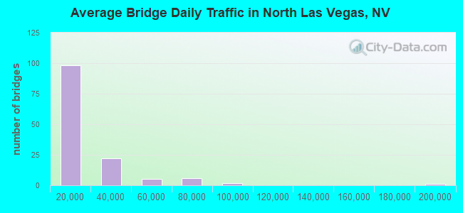
- 2,262,043Total average daily traffic
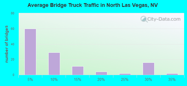
- 200,727Total average daily truck traffic
- National Bridge Inventory (NBI) Registered Bridges for North Las Vegas
- No street view available for this location
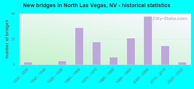
- New bridges - historical statistics
- 21930-1939
- 31950-1959
- 291960-1969
- 181970-1979
- 61980-1989
- 211990-1999
- 382000-2009
- 152010-2019
- 22020-2022
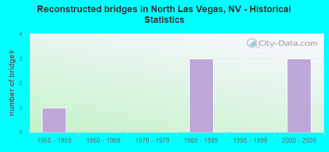
- Reconstructed bridges - Historical Statistics
- 11950-1959
- 01960-1969
- 01970-1979
- 31980-1989
- 01990-1999
- 32000-2009
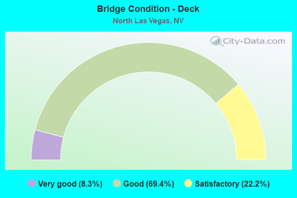
- Bridge Condition - Deck
- 8.3%Very good
- 69.4%Good
- 22.2%Satisfactory
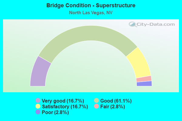
- Bridge Condition - Superstructure
- 16.7%Very good
- 61.1%Good
- 16.7%Satisfactory
- 2.8%Fair
- 2.8%Poor
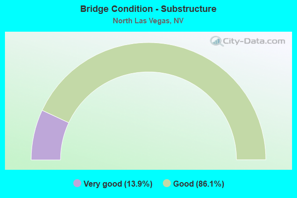
- Bridge Condition - Substructure
- 13.9%Very good
- 86.1%Good
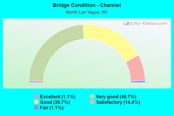
- Bridge Condition - Channel
- 1.1%Excellent
- 46.7%Very good
- 36.7%Good
- 14.4%Satisfactory
- 1.1%Fair
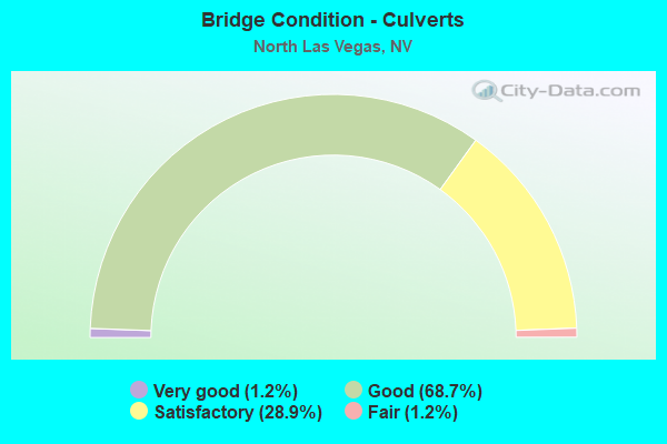
- Bridge Condition - Culverts
- 1.2%Very good
- 68.7%Good
- 28.9%Satisfactory
- 1.2%Fair
Find on map >> Show street view
Structure Number: B 313, Location: North of Las Vegas (Lat: 36.206956, Lng: -115.111764), Route carried "on" structure: US 604, Year Built: 1937, Year Reconstructed: 1957, Status: Open, Structure Length: 0.62m (2.03ft), Average Daily Traffic: 17,000 (year 2017), Truck Traffic: 2%, Average Future Daily Traffic: 35,158 (year 2040), Design Load: HS 20, Features Intersected: DRY WASH, Facility Carried by Structure: Las Vegas Blvd.
Minimum Vertical Clearance: 30+ m (98+ ft), Kilometerpoint: 0.000, Lanes on structure: 5, Owner: State Highway Agency, Approaching Roadway Width: 29.3m (96.1ft), Skew: 25 degrees, Material/Design: Concrete, Design/Construction: Culvert, Number Of Spans In Main Unit: 2, Length of Maximum Span: 3.0m (9.8ft)
Condition: Channel: Good, Culverts: Fair, Operating Rating: 40.6 metric tons, Method Used To Determine Operating Rating: Load Factor (LF), Inventory Rating: 24.5 metric tons, Method Used To Determine Inventory Rating: Load Factor (LF), Structural Evaluation: Somewhat better than minimum adequacy, Waterway Adequacy: Equal to present desirable criteria, Approach Roadway Alignment: Equal to present desirable criteria, Designated Inspection Frequency: Every 24 months, Inspection Date: Febuary 2021
Find on map >> Show street view
Structure Number: B 596S, Location: NORTH OF LAS VEGAS (Lat: 36.292661, Lng: -115.000019), Route carried "on" structure: Interstate 15, Year Built: 1963, Status: Open, Structure Length: 0.79m (2.59ft), Average Daily Traffic: 12,000 (year 2017), Truck Traffic: 25%, Average Future Daily Traffic: 24,817 (year 2040), Design Load: HS 20, Features Intersected: DRY WASH
Minimum Vertical Clearance: 30+ m (98+ ft), Kilometerpoint: 88.899, Lanes on structure: 2, Base Highway Network: Yes, Owner: State Highway Agency, Approaching Roadway Width: 11.6m (38.1ft), Skew: 3 degrees, Material/Design: Concrete, Design/Construction: Culvert, Number Of Spans In Main Unit: 2, Length of Maximum Span: 3.7m (12.1ft)
Condition: Channel: Satisfactory, Culverts: Good, Operating Rating: 47.8 metric tons, Method Used To Determine Operating Rating: Load Factor (LF), Inventory Rating: 28.7 metric tons, Method Used To Determine Inventory Rating: Load Factor (LF), Structural Evaluation: Better than present minimum criteria, Waterway Adequacy: Equal to present desirable criteria, Approach Roadway Alignment: Equal to present desirable criteria, Designated Inspection Frequency: Every 24 months, Inspection Date: October 2020
Find on map >> Show street view
Structure Number: B 690N, Location: NORTH LAS VEGAS (Lat: 36.471986, Lng: -114.820817), Route carried "on" structure: Interstate 15, Year Built: 1958, Status: Open, Structure Length: 1.31m (4.30ft), Average Daily Traffic: 12,800 (year 2017), Truck Traffic: 25%, Average Future Daily Traffic: 26,472 (year 2040), Design Load: HS 20, Features Intersected: DRY WASH
Minimum Vertical Clearance: 30+ m (98+ ft), Kilometerpoint: 115.559, Lanes on structure: 2, Base Highway Network: Yes, Owner: State Highway Agency, Approaching Roadway Width: 11.6m (38.1ft), Material/Design: Concrete, Design/Construction: Culvert, Number Of Spans In Main Unit: 4, Length of Maximum Span: 3.0m (9.8ft), Curb-To-Curb Width: 11.6m (38.1ft), Out-to-Out Width: 14.3m (46.9ft)
Condition: Channel: Satisfactory, Culverts: Satisfactory, Inventory Rating: 58.9 metric tons, Method Used To Determine Inventory Rating: Load Factor (LF), Structural Evaluation: Equal to present minimum criteria, Deck Geometry: Equal to present minimum criteria, Waterway Adequacy: Equal to present desirable criteria, Approach Roadway Alignment: Equal to present desirable criteria, Designated Inspection Frequency: Every 48 months, Inspection Date: November 2020
Find on map >> Show street view
Structure Number: B 691S, Location: NORTH LAS VEGAS (Lat: 36.472256, Lng: -114.821075), Route carried "on" structure: Interstate 15, Year Built: 1958, Status: Open, Structure Length: 1.34m (4.40ft), Average Daily Traffic: 12,800 (year 2017), Truck Traffic: 25%, Average Future Daily Traffic: 26,472 (year 2040), Design Load: HS 20, Features Intersected: DRY WASH
Minimum Vertical Clearance: 30+ m (98+ ft), Kilometerpoint: 0.000, Lanes on structure: 2, Base Highway Network: Yes, Owner: State Highway Agency, Approaching Roadway Width: 11.6m (38.1ft), Material/Design: Concrete, Design/Construction: Culvert, Number Of Spans In Main Unit: 4, Length of Maximum Span: 3.0m (9.8ft), Curb-To-Curb Width: 11.6m (38.1ft), Out-to-Out Width: 14.3m (46.9ft)
Condition: Channel: Good, Culverts: Satisfactory, Inventory Rating: 58.9 metric tons, Method Used To Determine Inventory Rating: Load Factor (LF), Structural Evaluation: Equal to present minimum criteria, Deck Geometry: Equal to present minimum criteria, Waterway Adequacy: Equal to present desirable criteria, Approach Roadway Alignment: Equal to present desirable criteria, Designated Inspection Frequency: Every 48 months, Inspection Date: November 2020
Find on map >> Show street view
Structure Number: B 696, Location: NORTH LAS VEGAS (Lat: 36.427228, Lng: -114.863122), Route carried "on" structure: Interstate 15, Year Built: 1958, Status: Open, Structure Length: 0.62m (2.03ft), Average Daily Traffic: 25,600 (year 2017), Truck Traffic: 24%, Average Future Daily Traffic: 52,944 (year 2040), Design Load: HS 20, Features Intersected: DRY WASH
Minimum Vertical Clearance: 30+ m (98+ ft), Kilometerpoint: 109.252, Lanes on structure: 4, Base Highway Network: Yes, Owner: State Highway Agency, Approaching Roadway Width: 23.2m (76.1ft), Skew: 10 degrees, Material/Design: Concrete, Design/Construction: Culvert, Number Of Spans In Main Unit: 2, Length of Maximum Span: 3.1m (10.2ft)
Condition: Channel: Good, Culverts: Good, Operating Rating: 44.9 metric tons, Method Used To Determine Operating Rating: Load Factor (LF), Inventory Rating: 26.9 metric tons, Method Used To Determine Inventory Rating: Load Factor (LF), Structural Evaluation: Equal to present minimum criteria, Waterway Adequacy: Equal to present desirable criteria, Approach Roadway Alignment: Equal to present desirable criteria, Designated Inspection Frequency: Every 24 months, Inspection Date: November 2020
Find on map >> Show street view
Structure Number: B 954S, Location: NORTH LAS VEGAS (Lat: 36.225322, Lng: -115.118569), Route carried "on" structure: Interstate 15, Year Built: 1970, Status: Open, Structure Length: 4.02m (13.19ft), Average Daily Traffic: 49,000 (year 2017), Truck Traffic: 6%, Average Future Daily Traffic: 101,338 (year 2040), Design Load: HS 20+Mod, Features Intersected: LAS VEGAS WASH
Minimum Vertical Clearance: 30+ m (98+ ft), Kilometerpoint: 75.721, Lanes on structure: 4, Base Highway Network: Yes, Owner: State Highway Agency, Approaching Roadway Width: 21.9m (71.9ft), Material/Design: Concrete continuous, Design/Construction: Box Beam or Girders - Multiple, Number Of Spans In Main Unit: 3, Length of Maximum Span: 15.8m (51.8ft), Curb-To-Curb Width: 21.9m (71.9ft), Out-to-Out Width: 23.0m (75.5ft)
Condition: Deck: Good, Superstructure: Good, Substructure: Good, Channel: Very good, Operating Rating: 53.4 metric tons, Method Used To Determine Operating Rating: Load Factor (LF), Inventory Rating: 31.9 metric tons, Method Used To Determine Inventory Rating: Load Factor (LF), Structural Evaluation: Better than present minimum criteria, Deck Geometry: Better than present minimum criteria, Waterway Adequacy: Equal to present desirable criteria, Approach Roadway Alignment: Equal to present desirable criteria, Designated Inspection Frequency: Every 24 months, Inspection Date: January 2021, Deck Structure Type: Concrete Cast-file-Place, Wearing Surface/Protective System: Wearing Surface: Epoxy Overlay
Find on map >> Show street view
Structure Number: B 957, Location: NORTH LAS VEGAS (Lat: 36.233772, Lng: -115.109856), Route carried "on" structure: Interstate 15, Year Built: 1970, Status: Open, Structure Length: 0.82m (2.69ft), Average Daily Traffic: 98,000 (year 2017), Truck Traffic: 6%, Average Future Daily Traffic: 113,000 (year 2040), Design Load: HS 20+Mod, Features Intersected: DRY WASH
Minimum Vertical Clearance: 30+ m (98+ ft), Kilometerpoint: 76.931, Lanes on structure: 8, Base Highway Network: Yes, Owner: State Highway Agency, Approaching Roadway Width: 25.0m (82.0ft), Skew: 20 degrees, Material/Design: Concrete, Design/Construction: Culvert, Number Of Spans In Main Unit: 2, Length of Maximum Span: 3.7m (12.1ft)
Condition: Channel: Satisfactory, Culverts: Satisfactory, Operating Rating: 58.0 metric tons, Method Used To Determine Operating Rating: Load Factor (LF), Inventory Rating: 34.8 metric tons, Method Used To Determine Inventory Rating: Load Factor (LF), Structural Evaluation: Equal to present minimum criteria, Waterway Adequacy: Equal to present desirable criteria, Approach Roadway Alignment: Equal to present desirable criteria, Length Of Structure Improvement: 1.48m (4.86ft), Designated Inspection Frequency: Every 48 months, Inspection Date: January 2021, Bridge Improvement Cost: $281,000, Roadway Improvement Cost: $28,000, Total Project Cost: $422,000
Find on map >> Show street view
Structure Number: B 963N, Location: NORTH LAS VEGAS (Lat: 36.276917, Lng: -115.040869), Route carried "on" structure: Interstate 15, Year Built: 1963, Status: Open, Structure Length: 1.59m (5.22ft), Average Daily Traffic: 17,500 (year 2017), Truck Traffic: 5%, Average Future Daily Traffic: 36,192 (year 2040), Design Load: HS 20+Mod, Features Intersected: DRY WASH
Minimum Vertical Clearance: 30+ m (98+ ft), Kilometerpoint: 84.875, Lanes on structure: 4, Base Highway Network: Yes, Owner: State Highway Agency, Approaching Roadway Width: 23.8m (78.1ft), Skew: 4 degrees, Material/Design: Concrete, Design/Construction: Culvert, Number Of Spans In Main Unit: 3, Length of Maximum Span: 5.2m (17.1ft)
Condition: Channel: Very good, Culverts: Good, Operating Rating: 59.0 metric tons, Method Used To Determine Operating Rating: Load Factor (LF), Inventory Rating: 35.4 metric tons, Method Used To Determine Inventory Rating: Load Factor (LF), Structural Evaluation: Better than present minimum criteria, Waterway Adequacy: Equal to present desirable criteria, Approach Roadway Alignment: Equal to present desirable criteria, Designated Inspection Frequency: Every 48 months, Inspection Date: November 2020
Find on map >> Show street view
Structure Number: B 963S, Location: NORTH LAS VEGAS (Lat: 36.277103, Lng: -115.041428), Route carried "on" structure: Interstate 15, Year Built: 1963, Status: Open, Structure Length: 1.59m (5.22ft), Average Daily Traffic: 17,500 (year 2017), Truck Traffic: 5%, Average Future Daily Traffic: 36,192 (year 2040), Design Load: HS 20+Mod, Features Intersected: DRY WASH
Minimum Vertical Clearance: 30+ m (98+ ft), Kilometerpoint: 84.875, Lanes on structure: 4, Base Highway Network: Yes, Owner: State Highway Agency, Approaching Roadway Width: 23.5m (77.1ft), Skew: 4 degrees, Material/Design: Concrete, Design/Construction: Culvert, Number Of Spans In Main Unit: 3, Length of Maximum Span: 5.2m (17.1ft)
Condition: Channel: Very good, Culverts: Good, Operating Rating: 59.0 metric tons, Method Used To Determine Operating Rating: Load Factor (LF), Inventory Rating: 35.4 metric tons, Method Used To Determine Inventory Rating: Load Factor (LF), Structural Evaluation: Better than present minimum criteria, Waterway Adequacy: Equal to present desirable criteria, Approach Roadway Alignment: Equal to present desirable criteria, Designated Inspection Frequency: Every 48 months, Inspection Date: November 2020
Find on map >> Show street view
Structure Number: B 964, Location: NORTH LAS VEGAS (Lat: 36.280067, Lng: -115.032947), Route carried "on" structure: Interstate 15, Year Built: 2018, Status: Open, Structure Length: 0.64m (2.10ft), Average Daily Traffic: 35,000 (year 2017), Truck Traffic: 5%, Average Future Daily Traffic: 40,000 (year 2037), Design Load: HL 93, Features Intersected: WASH
Minimum Vertical Clearance: 30+ m (98+ ft), Kilometerpoint: 85.649, Lanes on structure: 6, Base Highway Network: Yes, Owner: State Highway Agency, Approaching Roadway Width: 46.0m (150.9ft), Skew: 12 degrees, Material/Design: Concrete, Design/Construction: Culvert, Number Of Spans In Main Unit: 2, Length of Maximum Span: 3.0m (9.8ft)
Condition: Channel: Good, Culverts: Satisfactory, Operating Rating: 71.5 metric tons, Method Used To Determine Operating Rating: Load Factor (LF), Inventory Rating: 43.1 metric tons, Method Used To Determine Inventory Rating: Load Factor (LF), Structural Evaluation: Equal to present minimum criteria, Waterway Adequacy: Equal to present desirable criteria, Approach Roadway Alignment: Equal to present desirable criteria, Designated Inspection Frequency: Every 48 months, Inspection Date: November 2020
Find on map >> Show street view
Structure Number: B 966N, Location: NORTH LAS VEGAS (Lat: 36.287619, Lng: -115.012131), Route carried "on" structure: Interstate 15, Year Built: 1963, Status: Open, Structure Length: 1.21m (3.97ft), Average Daily Traffic: 12,000 (year 2017), Truck Traffic: 26%, Average Future Daily Traffic: 24,817 (year 2040), Design Load: HS 20, Features Intersected: DRY WASH
Minimum Vertical Clearance: 30+ m (98+ ft), Kilometerpoint: 87.727, Lanes on structure: 2, Base Highway Network: Yes, Owner: State Highway Agency, Approaching Roadway Width: 11.6m (38.1ft), Skew: 2 degrees, Material/Design: Concrete, Design/Construction: Culvert, Number Of Spans In Main Unit: 3, Length of Maximum Span: 4.0m (13.1ft)
Condition: Channel: Good, Culverts: Good, Operating Rating: 59.2 metric tons, Method Used To Determine Operating Rating: Load Factor (LF), Inventory Rating: 35.6 metric tons, Method Used To Determine Inventory Rating: Load Factor (LF), Structural Evaluation: Better than present minimum criteria, Waterway Adequacy: Equal to present desirable criteria, Approach Roadway Alignment: Equal to present desirable criteria, Designated Inspection Frequency: Every 48 months, Inspection Date: October 2020
Find on map >> Show street view
Structure Number: B 966S, Location: NORTH LAS VEGAS (Lat: 36.288158, Lng: -115.011872), Route carried "on" structure: Interstate 15, Year Built: 1963, Status: Open, Structure Length: 1.28m (4.20ft), Average Daily Traffic: 12,000 (year 2017), Truck Traffic: 5%, Average Future Daily Traffic: 24,817 (year 2040), Design Load: HS 20, Features Intersected: DRY WASH
Minimum Vertical Clearance: 30+ m (98+ ft), Kilometerpoint: 87.727, Lanes on structure: 2, Base Highway Network: Yes, Owner: State Highway Agency, Approaching Roadway Width: 11.6m (38.1ft), Skew: 2 degrees, Material/Design: Concrete, Design/Construction: Culvert, Number Of Spans In Main Unit: 3, Length of Maximum Span: 4.0m (13.1ft)
Condition: Channel: Good, Culverts: Good, Operating Rating: 59.2 metric tons, Method Used To Determine Operating Rating: Load Factor (LF), Inventory Rating: 35.6 metric tons, Method Used To Determine Inventory Rating: Load Factor (LF), Structural Evaluation: Better than present minimum criteria, Waterway Adequacy: Equal to present desirable criteria, Approach Roadway Alignment: Equal to present desirable criteria, Designated Inspection Frequency: Every 48 months, Inspection Date: October 2020
Find on map >> Show street view
Structure Number: B 967N, Location: NORTH LAS VEGAS (Lat: 36.297675, Lng: -114.985417), Route carried "on" structure: Interstate 15, Year Built: 1963, Status: Open, Structure Length: 1.25m (4.10ft), Average Daily Traffic: 12,000 (year 2017), Truck Traffic: 5%, Average Future Daily Traffic: 24,817 (year 2040), Design Load: HS 20, Features Intersected: DRY WASH
Minimum Vertical Clearance: 30+ m (98+ ft), Kilometerpoint: 90.374, Lanes on structure: 2, Base Highway Network: Yes, Owner: State Highway Agency, Approaching Roadway Width: 11.6m (38.1ft), Skew: 2 degrees, Material/Design: Concrete, Design/Construction: Culvert, Number Of Spans In Main Unit: 3, Length of Maximum Span: 3.7m (12.1ft)
Condition: Channel: Good, Culverts: Satisfactory, Inventory Rating: 70.5 metric tons, Method Used To Determine Inventory Rating: Load Factor (LF), Structural Evaluation: Equal to present minimum criteria, Waterway Adequacy: Equal to present desirable criteria, Approach Roadway Alignment: Equal to present desirable criteria, Designated Inspection Frequency: Every 48 months, Inspection Date: October 2020
Find on map >> Show street view
Structure Number: B 967S, Location: NORTH LAS VEGAS (Lat: 36.298119, Lng: -114.985303), Route carried "on" structure: Interstate 15, Year Built: 1963, Status: Open, Structure Length: 1.20m (3.94ft), Average Daily Traffic: 12,000 (year 2017), Truck Traffic: 5%, Average Future Daily Traffic: 24,817 (year 2040), Design Load: HS 20, Features Intersected: DRY WASH
Minimum Vertical Clearance: 30+ m (98+ ft), Kilometerpoint: 90.374, Lanes on structure: 2, Base Highway Network: Yes, Owner: State Highway Agency, Approaching Roadway Width: 11.6m (38.1ft), Skew: 2 degrees, Material/Design: Concrete, Design/Construction: Culvert, Number Of Spans In Main Unit: 3, Length of Maximum Span: 3.8m (12.5ft)
Condition: Channel: Satisfactory, Culverts: Good, Inventory Rating: 70.5 metric tons, Method Used To Determine Inventory Rating: Load Factor (LF), Structural Evaluation: Better than present minimum criteria, Waterway Adequacy: Equal to present desirable criteria, Approach Roadway Alignment: Equal to present desirable criteria, Designated Inspection Frequency: Every 48 months, Inspection Date: October 2020
Find on map >> Show street view
Structure Number: B 976, Location: NORTH LAS VEGAS (Lat: 36.251422, Lng: -115.088150), Route carried "on" structure: Interstate 15, Year Built: 1970, Status: Open, Structure Length: 1.37m (4.49ft), Average Daily Traffic: 54,000 (year 2017), Truck Traffic: 30%, Average Future Daily Traffic: 68,000 (year 2040), Design Load: HS 20, Features Intersected: VANDENBERG WASH
Minimum Vertical Clearance: 30+ m (98+ ft), Kilometerpoint: 79.663, Lanes on structure: 8, Base Highway Network: Yes, Owner: State Highway Agency, Approaching Roadway Width: 11.6m (38.1ft), Skew: 13 degrees, Material/Design: Concrete, Design/Construction: Culvert, Number Of Spans In Main Unit: 3, Length of Maximum Span: 4.3m (14.1ft)
Condition: Channel: Good, Culverts: Satisfactory, Inventory Rating: 57.8 metric tons, Method Used To Determine Inventory Rating: Load Factor (LF), Structural Evaluation: Equal to present minimum criteria, Waterway Adequacy: Equal to present desirable criteria, Approach Roadway Alignment: Equal to present desirable criteria, Length Of Structure Improvement: 2.04m (6.69ft), Designated Inspection Frequency: Every 48 months, Inspection Date: November 2020, Bridge Improvement Cost: $194,000, Roadway Improvement Cost: $19,000, Total Project Cost: $292,000
Find on map >> Show street view
Structure Number: B1021N, Location: NEAR LAS VEGAS (Lat: 36.299100, Lng: -114.981600), Route carried "on" structure: Interstate 15, Year Built: 1963, Year Reconstructed: 2012, Status: Open, Structure Length: 1.07m (3.51ft), Average Daily Traffic: 12,000 (year 2017), Truck Traffic: 26%, Average Future Daily Traffic: 24,817 (year 2040), Design Load: HS 20, Features Intersected: DRY WASH
Minimum Vertical Clearance: 30+ m (98+ ft), Kilometerpoint: 90.744, Lanes on structure: 2, Base Highway Network: Yes, Owner: State Highway Agency, Approaching Roadway Width: 11.6m (38.1ft), Skew: 4 degrees, Material/Design: Concrete, Design/Construction: Culvert, Number Of Spans In Main Unit: 2, Length of Maximum Span: 5.2m (17.1ft)
Condition: Channel: Good, Culverts: Good, Operating Rating: 56.3 metric tons, Method Used To Determine Operating Rating: Load Factor (LF), Inventory Rating: 33.8 metric tons, Method Used To Determine Inventory Rating: Load Factor (LF), Structural Evaluation: Better than present minimum criteria, Waterway Adequacy: Equal to present desirable criteria, Approach Roadway Alignment: Equal to present desirable criteria, Designated Inspection Frequency: Every 48 months, Inspection Date: October 2018
Find on map >> Show street view
Structure Number: B1021S, Location: NEAR LAS VEGAS (Lat: 36.299681, Lng: -114.981125), Route carried "on" structure: Interstate 15, Year Built: 1963, Year Reconstructed: 2012, Status: Open, Structure Length: 1.07m (3.51ft), Average Daily Traffic: 12,000 (year 2017), Truck Traffic: 26%, Average Future Daily Traffic: 24,817 (year 2040), Design Load: HS 20, Features Intersected: DRY WASH
Minimum Vertical Clearance: 30+ m (98+ ft), Kilometerpoint: 90.744, Lanes on structure: 2, Base Highway Network: Yes, Owner: State Highway Agency, Approaching Roadway Width: 11.9m (39.0ft), Skew: 4 degrees, Material/Design: Concrete, Design/Construction: Culvert, Number Of Spans In Main Unit: 2, Length of Maximum Span: 5.3m (17.4ft)
Condition: Channel: Good, Culverts: Good, Operating Rating: 56.3 metric tons, Method Used To Determine Operating Rating: Load Factor (LF), Inventory Rating: 33.8 metric tons, Method Used To Determine Inventory Rating: Load Factor (LF), Structural Evaluation: Better than present minimum criteria, Waterway Adequacy: Equal to present desirable criteria, Approach Roadway Alignment: Equal to present desirable criteria, Designated Inspection Frequency: Every 48 months, Inspection Date: October 2018
Find on map >> Show street view
Structure Number: B1043N, Location: NORTH OF LAS VEGAS (Lat: 36.284853, Lng: -115.019544), Route carried "on" structure: Interstate 15, Year Built: 1963, Status: Open, Structure Length: 0.70m (2.30ft), Average Daily Traffic: 11,625 (year 2017), Truck Traffic: 26%, Average Future Daily Traffic: 24,042 (year 2040), Design Load: HS 20, Features Intersected: DRY WASH
Minimum Vertical Clearance: 30+ m (98+ ft), Kilometerpoint: 86.985, Lanes on structure: 3, Base Highway Network: Yes, Owner: State Highway Agency, Approaching Roadway Width: 15.7m (51.5ft), Skew: 3 degrees, Material/Design: Concrete, Design/Construction: Culvert, Number Of Spans In Main Unit: 2, Length of Maximum Span: 3.4m (11.2ft)
Condition: Channel: Good, Culverts: Good, Operating Rating: 39.8 metric tons, Method Used To Determine Operating Rating: Load Factor (LF), Inventory Rating: 23.8 metric tons, Method Used To Determine Inventory Rating: Load Factor (LF), Structural Evaluation: Somewhat better than minimum adequacy, Waterway Adequacy: Equal to present desirable criteria, Approach Roadway Alignment: Equal to present desirable criteria, Designated Inspection Frequency: Every 24 months, Inspection Date: November 2020
Find on map >> Show street view
Structure Number: B1043S, Location: NORTH OF LAS VEGAS (Lat: 36.285392, Lng: -115.019269), Route carried "on" structure: Interstate 15, Year Built: 1963, Status: Open, Structure Length: 0.69m (2.26ft), Average Daily Traffic: 11,625 (year 2017), Truck Traffic: 26%, Average Future Daily Traffic: 24,042 (year 2040), Design Load: HS 20, Features Intersected: DRY WASH
Minimum Vertical Clearance: 30+ m (98+ ft), Kilometerpoint: 86.985, Lanes on structure: 2, Base Highway Network: Yes, Owner: State Highway Agency, Approaching Roadway Width: 11.6m (38.1ft), Skew: 3 degrees, Material/Design: Concrete, Design/Construction: Culvert, Number Of Spans In Main Unit: 2, Length of Maximum Span: 3.5m (11.5ft)
Condition: Channel: Good, Culverts: Good, Operating Rating: 39.8 metric tons, Method Used To Determine Operating Rating: Load Factor (LF), Inventory Rating: 23.8 metric tons, Method Used To Determine Inventory Rating: Load Factor (LF), Structural Evaluation: Somewhat better than minimum adequacy, Waterway Adequacy: Equal to present desirable criteria, Approach Roadway Alignment: Equal to present desirable criteria, Designated Inspection Frequency: Every 24 months, Inspection Date: November 2020
Find on map >> Show street view
Structure Number: B1052, Location: NORTH OF LAS VEGAS (Lat: 36.310222, Lng: -114.953972), Route carried "on" structure: Interstate 15, Year Built: 1963, Status: Open, Structure Length: 1.22m (4.00ft), Average Daily Traffic: 24,500 (year 2017), Truck Traffic: 25%, Average Future Daily Traffic: 50,669 (year 2040), Design Load: HS 20, Features Intersected: DRY WASH
Minimum Vertical Clearance: 30+ m (98+ ft), Kilometerpoint: 93.463, Lanes on structure: 6, Base Highway Network: Yes, Owner: State Highway Agency, Approaching Roadway Width: 23.2m (76.1ft), Skew: 21 degrees, Material/Design: Concrete, Design/Construction: Culvert, Number Of Spans In Main Unit: 3, Length of Maximum Span: 3.7m (12.1ft)
Condition: Channel: Good, Culverts: Good, Operating Rating: 56.3 metric tons, Method Used To Determine Operating Rating: Load Factor (LF), Inventory Rating: 33.7 metric tons, Method Used To Determine Inventory Rating: Load Factor (LF), Structural Evaluation: Better than present minimum criteria, Waterway Adequacy: Equal to present desirable criteria, Approach Roadway Alignment: Equal to present desirable criteria, Designated Inspection Frequency: Every 48 months, Inspection Date: November 2020
Find on map >> Show street view
Structure Number: B107, Location: NORTHWEST OF VEGAS (Lat: 36.337522, Lng: -114.916522), Route carried "on" structure: Interstate 15, Year Built: 1963, Year Reconstructed: 1980, Status: Open, Structure Length: 0.79m (2.59ft), Average Daily Traffic: 29,900 (year 2017), Truck Traffic: 27%, Average Future Daily Traffic: 50,000 (year 2040), Design Load: HS 20, Features Intersected: DRY WASH
Minimum Vertical Clearance: 30+ m (98+ ft), Kilometerpoint: 98.146, Lanes on structure: 5, Base Highway Network: Yes, Owner: State Highway Agency, Approaching Roadway Width: 26.9m (88.3ft), Skew: 13 degrees, Material/Design: Concrete, Design/Construction: Culvert, Number Of Spans In Main Unit: 2, Length of Maximum Span: 3.7m (12.1ft)
Condition: Channel: Satisfactory, Culverts: Good, Operating Rating: 39.2 metric tons, Method Used To Determine Operating Rating: Load Factor (LF), Inventory Rating: 23.5 metric tons, Method Used To Determine Inventory Rating: Load Factor (LF), Structural Evaluation: Somewhat better than minimum adequacy, Waterway Adequacy: Equal to present desirable criteria, Approach Roadway Alignment: Equal to present desirable criteria, Designated Inspection Frequency: Every 24 months, Inspection Date: November 2020
Find on map >> Show street view
Structure Number: B1072, Location: NORTH OF LAS VEGAS (Lat: 36.350711, Lng: -114.905878), Route carried "on" structure: Interstate 15, Year Built: 1963, Year Reconstructed: 1980, Status: Open, Structure Length: 0.94m (3.08ft), Average Daily Traffic: 29,900 (year 2017), Truck Traffic: 24%, Average Future Daily Traffic: 50,000 (year 2040), Design Load: HS 20, Features Intersected: DRY WASH
Minimum Vertical Clearance: 30+ m (98+ ft), Kilometerpoint: 99.861, Lanes on structure: 4, Base Highway Network: Yes, Owner: State Highway Agency, Approaching Roadway Width: 23.2m (76.1ft), Skew: 13 degrees, Material/Design: Concrete, Design/Construction: Culvert, Number Of Spans In Main Unit: 2, Length of Maximum Span: 4.3m (14.1ft)
Condition: Channel: Satisfactory, Culverts: Good, Operating Rating: 71.8 metric tons, Method Used To Determine Operating Rating: Load Factor (LF), Inventory Rating: 43.1 metric tons, Method Used To Determine Inventory Rating: Load Factor (LF), Structural Evaluation: Better than present minimum criteria, Waterway Adequacy: Equal to present desirable criteria, Approach Roadway Alignment: Equal to present desirable criteria, Designated Inspection Frequency: Every 48 months, Inspection Date: November 2020
Find on map >> Show street view
Structure Number: B1418, Location: NORTH LAS VEGAS (Lat: 36.258614, Lng: -115.023375), Route carried "on" structure: State highway 604, Year Built: 1974, Status: Open, Structure Length: 1.29m (4.23ft), Average Daily Traffic: 3,900 (year 2017), Truck Traffic: 5%, Average Future Daily Traffic: 8,066 (year 2040), Design Load: HS 20+Mod, Features Intersected: DRY WASH
Minimum Vertical Clearance: 30+ m (98+ ft), Kilometerpoint: 63.934, Lanes on structure: 4, Base Highway Network: Yes, Owner: State Highway Agency, Approaching Roadway Width: 26.1m (85.6ft), Material/Design: Concrete, Design/Construction: Culvert, Number Of Spans In Main Unit: 4, Length of Maximum Span: 3.0m (9.8ft)
Condition: Channel: Satisfactory, Culverts: Good, Operating Rating: 37.0 metric tons, Method Used To Determine Operating Rating: Load Factor (LF), Inventory Rating: 22.1 metric tons, Method Used To Determine Inventory Rating: Load Factor (LF), Structural Evaluation: Somewhat better than minimum adequacy, Waterway Adequacy: Equal to present desirable criteria, Approach Roadway Alignment: Equal to present desirable criteria, Designated Inspection Frequency: Every 24 months, Inspection Date: November 2020
Find on map >> Show street view
Structure Number: B1419, Location: NORTH LAS VEGAS (Lat: 36.265753, Lng: -115.011125), Route carried "on" structure: US 143, Year Built: 1974, Status: Open, Structure Length: 0.96m (3.15ft), Average Daily Traffic: 3,200 (year 2017), Truck Traffic: 5%, Average Future Daily Traffic: 4,650 (year 2040), Design Load: HS 20, Features Intersected: DRY WASH, Facility Carried by Structure: SR604/LAS VEGAS BL
Minimum Vertical Clearance: 30+ m (98+ ft), Kilometerpoint: 65.293, Lanes on structure: 3, Base Highway Network: Yes, Owner: State Highway Agency, Approaching Roadway Width: 16.8m (55.1ft), Material/Design: Concrete, Design/Construction: Culvert, Number Of Spans In Main Unit: 3, Length of Maximum Span: 3.1m (10.2ft)
Condition: Channel: Satisfactory, Culverts: Satisfactory, Operating Rating: 32.7 metric tons, Method Used To Determine Operating Rating: Load Factor (LF), Inventory Rating: 19.2 metric tons, Method Used To Determine Inventory Rating: Load Factor (LF), Structural Evaluation: Somewhat better than minimum adequacy, Waterway Adequacy: Equal to present desirable criteria, Approach Roadway Alignment: Equal to present desirable criteria, Designated Inspection Frequency: Every 24 months, Inspection Date: November 2020
Find on map >> Show street view
Structure Number: B1528, Location: NORTH LAS VEGAS (Lat: 36.240397, Lng: -115.084261), Route carried "on" structure: City street 573, Year Built: 1966, Status: Open, Structure Length: 0.67m (2.20ft), Average Daily Traffic: 34,000 (year 2017), Truck Traffic: 4%, Average Future Daily Traffic: 70,316 (year 2040), Design Load: HS 20+Mod, Features Intersected: VANDENBERG WASH
Minimum Vertical Clearance: 30+ m (98+ ft), Kilometerpoint: 0.000, Lanes on structure: 6, Base Highway Network: Yes, Owner: City or Municipal Highway Agency, Approaching Roadway Width: 30.5m (100.1ft), Material/Design: Concrete, Design/Construction: Culvert, Number Of Spans In Main Unit: 2, Length of Maximum Span: 3.0m (9.8ft), Curb or Sidewalk Widths: Left: 1.5m (4.9ft), Right: 0.0m
Condition: Channel: Very good, Culverts: Satisfactory, Operating Rating: 37.6 metric tons, Method Used To Determine Operating Rating: Load Factor (LF), Inventory Rating: 22.5 metric tons, Method Used To Determine Inventory Rating: Load Factor (LF), Structural Evaluation: Somewhat better than minimum adequacy, Waterway Adequacy: Equal to present desirable criteria, Approach Roadway Alignment: Equal to present desirable criteria, Length Of Structure Improvement: 1.30m (4.27ft), Designated Inspection Frequency: Every 24 months, Inspection Date: January 2021, Bridge Improvement Cost: $325,000, Roadway Improvement Cost: $32,000, Total Project Cost: $487,000, Wearing Surface/Protective System: Wearing Surface: Bituminous
Find on map >> Show street view
Structure Number: B1535, Location: NORTH LAS VEGAS (Lat: 36.217700, Lng: -115.111442), Route carried "on" structure: City street SR574, Year Built: 2006, Status: Open, Structure Length: 3.47m (11.38ft), Average Daily Traffic: 36,000 (year 2017), Truck Traffic: 5%, Average Future Daily Traffic: 74,452 (year 2040), Design Load: HS 20+Mod, Features Intersected: LAS VEGAS WASH
Minimum Vertical Clearance: 30+ m (98+ ft), Kilometerpoint: 0.000, Lanes on structure: 7, Owner: City or Municipal Highway Agency, Approaching Roadway Width: 25.8m (84.6ft), Skew: 3 degrees, Material/Design: Steel, Design/Construction: Stringer/Multi-beam, Number Of Spans In Main Unit: 1, Length of Maximum Span: 33.0m (108.3ft), Curb or Sidewalk Widths: Left: 2.2m (7.2ft), Right: 2.2m (7.2ft), Curb-To-Curb Width: 25.8m (84.6ft), Out-to-Out Width: 31.3m (102.7ft)
Condition: Deck: Good, Superstructure: Very good, Substructure: Good, Channel: Very good, Operating Rating: 61.7 metric tons, Method Used To Determine Operating Rating: Load Factor (LF), Inventory Rating: 36.8 metric tons, Method Used To Determine Inventory Rating: Load Factor (LF), Structural Evaluation: Better than present minimum criteria, Deck Geometry: Meets minimum limits, Waterway Adequacy: Equal to present desirable criteria, Approach Roadway Alignment: Equal to present desirable criteria, Designated Inspection Frequency: Every 24 months, Inspection Date: December 2020, Deck Structure Type: Concrete Cast-file-Place, Wearing Surface/Protective System: Wearing Surface: Monolithic Concrete
Find on map >> Show street view
Structure Number: B1537, Location: NORTH LAS VEGAS (Lat: 36.195917, Lng: -115.098528), Route carried "on" structure: State highway 147, Year Built: 2012, Status: Open, Structure Length: 2.67m (8.76ft), Average Daily Traffic: 22,200 (year 2017), Truck Traffic: 2%, Average Future Daily Traffic: 45,912 (year 2040), Design Load: HS 20+Mod, Features Intersected: LAS VEGAS WASH
Minimum Vertical Clearance: 30+ m (98+ ft), Kilometerpoint: 0.000, Lanes on structure: 6, Owner: City or Municipal Highway Agency, Approaching Roadway Width: 25.9m (85.0ft), Skew: 23 degrees, Material/Design: Concrete, Design/Construction: Culvert, Number Of Spans In Main Unit: 3, Length of Maximum Span: 7.3m (24.0ft), Curb or Sidewalk Widths: Left: 2.3m (7.5ft), Right: 2.1m (6.9ft)
Condition: Channel: Very good, Culverts: Good, Operating Rating: 32.7 metric tons, Method Used To Determine Operating Rating: Field evaluation and documented engineering judgment, Inventory Rating: 19.6 metric tons, Method Used To Determine Inventory Rating: Field evaluation and documented engineering judgment, Structural Evaluation: Meets minimum limits, Waterway Adequacy: Equal to present desirable criteria, Approach Roadway Alignment: Equal to present desirable criteria, Designated Inspection Frequency: Every 24 months, Inspection Date: November 2021
Find on map >> Show street view
Structure Number: B1575, Location: NORTH LAS VEGAS (Lat: 36.203242, Lng: -115.104108), Route carried "on" structure: City street , Year Built: 2005, Status: Open, Structure Length: 3.05m (10.01ft), Average Daily Traffic: 5,000 (year 2017), Truck Traffic: 5%, Average Future Daily Traffic: 10,341 (year 2040), Design Load: HS 20+Mod, Features Intersected: LAS VEGAS WASH, Facility Carried by Structure: CAREY AV
Minimum Vertical Clearance: 30+ m (98+ ft), Kilometerpoint: 0.000, Lanes on structure: 2, Owner: City or Municipal Highway Agency, Approaching Roadway Width: 14.2m (46.6ft), Skew: 2 degrees, Material/Design: Steel, Design/Construction: Stringer/Multi-beam, Number Of Spans In Main Unit: 1, Length of Maximum Span: 29.3m (96.1ft), Curb or Sidewalk Widths: Left: 2.0m (6.6ft), Right: 2.1m (6.9ft), Curb-To-Curb Width: 14.2m (46.6ft), Out-to-Out Width: 19.2m (63.0ft)
Condition: Deck: Good, Superstructure: Satisfactory, Substructure: Good, Channel: Very good, Operating Rating: 64.3 metric tons, Method Used To Determine Operating Rating: Load Factor (LF), Inventory Rating: 38.5 metric tons, Method Used To Determine Inventory Rating: Load Factor (LF), Structural Evaluation: Equal to present minimum criteria, Deck Geometry: Superior to present desirable criteria, Waterway Adequacy: Equal to present desirable criteria, Approach Roadway Alignment: Equal to present desirable criteria, Designated Inspection Frequency: Every 24 months, Inspection Date: October 2021, Deck Structure Type: Concrete Cast-file-Place, Wearing Surface/Protective System: Wearing Surface: Monolithic Concrete
Find on map >> Show street view
Structure Number: B1577, Location: NORTH LAS VEGAS (Lat: 36.247231, Lng: -115.087622), Route carried "on" structure: City street , Year Built: 1966, Status: Open, Structure Length: 0.70m (2.30ft), Average Daily Traffic: 200 (year 2017), Truck Traffic: 1%, Average Future Daily Traffic: 414 (year 2040), Design Load: HS 20+Mod, Features Intersected: VANDENBERG WASH, Facility Carried by Structure: LONE MOUNTAIN RD
Minimum Vertical Clearance: 30+ m (98+ ft), Kilometerpoint: 0.000, Lanes on structure: 2, Owner: City or Municipal Highway Agency, Approaching Roadway Width: 22.9m (75.1ft), Material/Design: Concrete, Design/Construction: Culvert, Number Of Spans In Main Unit: 2, Length of Maximum Span: 3.0m (9.8ft), Curb-To-Curb Width: 22.9m (75.1ft), Out-to-Out Width: 26.4m (86.6ft)
Condition: Channel: Satisfactory, Culverts: Good, Operating Rating: 34.7 metric tons, Method Used To Determine Operating Rating: Load Factor (LF), Inventory Rating: 20.9 metric tons, Method Used To Determine Inventory Rating: Load Factor (LF), Structural Evaluation: Equal to present minimum criteria, Deck Geometry: Superior to present desirable criteria, Waterway Adequacy: Equal to present desirable criteria, Approach Roadway Alignment: Equal to present desirable criteria, Designated Inspection Frequency: Every 24 months, Inspection Date: January 2021, Deck Structure Type: Concrete Cast-file-Place, Wearing Surface/Protective System: Wearing Surface: Bituminous
Find on map >> Show street view
Structure Number: B1578, Location: NORTH LAS VEGAS (Lat: 36.245353, Lng: -115.086889), Route carried "on" structure: City street , Year Built: 1966, Status: Open, Structure Length: 0.70m (2.30ft), Average Daily Traffic: 200 (year 2017), Truck Traffic: 1%, Average Future Daily Traffic: 414 (year 2040), Design Load: HS 20+Mod, Features Intersected: VANDENBERG WASH, Facility Carried by Structure: CROSSOVER ROAD
Minimum Vertical Clearance: 30+ m (98+ ft), Kilometerpoint: 0.000, Lanes on structure: 2, Owner: City or Municipal Highway Agency, Approaching Roadway Width: 18.3m (60.0ft), Material/Design: Concrete, Design/Construction: Culvert, Number Of Spans In Main Unit: 2, Length of Maximum Span: 3.0m (9.8ft), Curb or Sidewalk Widths: Left: 1.5m (4.9ft), Right: 1.5m (4.9ft), Curb-To-Curb Width: 18.3m (60.0ft), Out-to-Out Width: 25.7m (84.3ft)
Condition: Channel: Satisfactory, Culverts: Satisfactory, Operating Rating: 52.0 metric tons, Method Used To Determine Operating Rating: Load Factor (LF), Inventory Rating: 31.1 metric tons, Method Used To Determine Inventory Rating: Load Factor (LF), Structural Evaluation: Equal to present minimum criteria, Deck Geometry: Superior to present desirable criteria, Waterway Adequacy: Equal to present desirable criteria, Approach Roadway Alignment: Equal to present desirable criteria, Designated Inspection Frequency: Every 24 months, Inspection Date: January 2021, Deck Structure Type: Concrete Cast-file-Place, Wearing Surface/Protective System: Wearing Surface: Bituminous
Find on map >> Show street view
Structure Number: B1579, Location: NORTH LAS VEGAS (Lat: 36.243047, Lng: -115.084889), Route carried "on" structure: City street , Year Built: 1966, Status: Open, Structure Length: 0.70m (2.30ft), Average Daily Traffic: 220 (year 2017), Truck Traffic: 1%, Average Future Daily Traffic: 455 (year 2040), Design Load: HS 20+Mod, Features Intersected: VANDENBERG WASH, Facility Carried by Structure: CROSSOVER ROAD
Minimum Vertical Clearance: 30+ m (98+ ft), Kilometerpoint: 0.000, Lanes on structure: 2, Owner: City or Municipal Highway Agency, Approaching Roadway Width: 18.3m (60.0ft), Material/Design: Concrete, Design/Construction: Culvert, Number Of Spans In Main Unit: 2, Length of Maximum Span: 3.0m (9.8ft), Curb or Sidewalk Widths: Left: 1.5m (4.9ft), Right: 1.5m (4.9ft), Curb-To-Curb Width: 18.3m (60.0ft), Out-to-Out Width: 24.7m (81.0ft)
Condition: Channel: Good, Culverts: Satisfactory, Operating Rating: 51.3 metric tons, Method Used To Determine Operating Rating: Load Factor (LF), Inventory Rating: 30.7 metric tons, Method Used To Determine Inventory Rating: Load Factor (LF), Structural Evaluation: Equal to present minimum criteria, Deck Geometry: Superior to present desirable criteria, Waterway Adequacy: Equal to present desirable criteria, Approach Roadway Alignment: Superior to present desirable criteria, Designated Inspection Frequency: Every 24 months, Inspection Date: January 2021, Deck Structure Type: Concrete Cast-file-Place, Wearing Surface/Protective System: Wearing Surface: Bituminous
Find on map >> Show street view
Structure Number: B1812, Location: NORTH LAS VEGAS (Lat: 36.226817, Lng: -115.120422), Route carried "on" structure: Business City street , Year Built: 1983, Status: Open, Structure Length: 4.05m (13.29ft), Average Daily Traffic: 22,000 (year 2017), Truck Traffic: 3%, Average Future Daily Traffic: 45,499 (year 2040), Design Load: HS 20, Features Intersected: FLOOD CHANNEL A, Facility Carried by Structure: LOSEE RD
Minimum Vertical Clearance: 30+ m (98+ ft), Kilometerpoint: 0.000, Lanes on structure: 4, Owner: City or Municipal Highway Agency, Approaching Roadway Width: 27.9m (91.5ft), Skew: 23 degrees, Material/Design: Concrete continuous, Design/Construction: Slab, Number Of Spans In Main Unit: 4, Length of Maximum Span: 10.1m (33.1ft), Curb or Sidewalk Widths: Left: 1.5m (4.9ft), Right: 1.5m (4.9ft), Curb-To-Curb Width: 27.9m (91.5ft), Out-to-Out Width: 31.1m (102.0ft)
Condition: Deck: Satisfactory, Superstructure: Satisfactory, Substructure: Good, Channel: Good, Operating Rating: 64.2 metric tons, Method Used To Determine Operating Rating: Load Factor (LF), Inventory Rating: 38.5 metric tons, Method Used To Determine Inventory Rating: Load Factor (LF), Structural Evaluation: Equal to present minimum criteria, Deck Geometry: Superior to present desirable criteria, Waterway Adequacy: Equal to present desirable criteria, Approach Roadway Alignment: Equal to present desirable criteria, Designated Inspection Frequency: Every 48 months, Inspection Date: January 2021, Deck Structure Type: Concrete Cast-file-Place, Wearing Surface/Protective System: Wearing Surface: Monolithic Concrete
Find on map >> Show street view
Structure Number: B1813, Location: NORTH LAS VEGAS (Lat: 36.223625, Lng: -115.116422), Route carried "on" structure: Business City street , Year Built: 1984, Status: Open, Structure Length: 3.81m (12.50ft), Average Daily Traffic: 9,300 (year 2017), Truck Traffic: 2%, Average Future Daily Traffic: 19,233 (year 2040), Design Load: HS 20, Features Intersected: LAS VEGAS WASH, Facility Carried by Structure: CIVIC CENTER DR
Minimum Vertical Clearance: 30+ m (98+ ft), Kilometerpoint: 0.000, Lanes on structure: 4, Owner: City or Municipal Highway Agency, Approaching Roadway Width: 19.5m (64.0ft), Skew: 1 degrees, Material/Design: Concrete continuous, Design/Construction: Slab, Number Of Spans In Main Unit: 3, Length of Maximum Span: 14.6m (47.9ft), Curb or Sidewalk Widths: Left: 1.7m (5.6ft), Right: 1.7m (5.6ft), Curb-To-Curb Width: 20.4m (66.9ft), Out-to-Out Width: 23.9m (78.4ft)
Condition: Deck: Satisfactory, Superstructure: Satisfactory, Substructure: Good, Channel: Very good, Operating Rating: 60.4 metric tons, Method Used To Determine Operating Rating: Load Factor (LF), Inventory Rating: 36.2 metric tons, Method Used To Determine Inventory Rating: Load Factor (LF), Structural Evaluation: Equal to present minimum criteria, Deck Geometry: Superior to present desirable criteria, Waterway Adequacy: Equal to present desirable criteria, Approach Roadway Alignment: Equal to present desirable criteria, Designated Inspection Frequency: Every 48 months, Inspection Date: December 2020, Deck Structure Type: Concrete Cast-file-Place, Wearing Surface/Protective System: Wearing Surface: Monolithic Concrete
Find on map >> Show street view
Structure Number: B1884, Location: NORTH LAS VEGAS (Lat: 36.239997, Lng: -115.112147), Route carried "on" structure: City street 573, Year Built: 1984, Status: Open, Structure Length: 1.86m (6.10ft), Average Daily Traffic: 68,000 (year 2017), Truck Traffic: 8%, Average Future Daily Traffic: 140,632 (year 2040), Design Load: HS 20, Features Intersected: LAS VEGAS WASH
Minimum Vertical Clearance: 30+ m (98+ ft), Kilometerpoint: 0.000, Lanes on structure: 9, Base Highway Network: Yes, Owner: City or Municipal Highway Agency, Approaching Roadway Width: 26.5m (86.9ft), Skew: 20 degrees, Material/Design: Concrete, Design/Construction: Culvert, Number Of Spans In Main Unit: 7, Length of Maximum Span: 2.4m (7.9ft)
Condition: Channel: Good, Culverts: Satisfactory, Operating Rating: 42.9 metric tons, Method Used To Determine Operating Rating: Load Factor (LF), Inventory Rating: 25.8 metric tons, Method Used To Determine Inventory Rating: Load Factor (LF), Structural Evaluation: Equal to present minimum criteria, Waterway Adequacy: Equal to present desirable criteria, Approach Roadway Alignment: Equal to present desirable criteria, Length Of Structure Improvement: 2.58m (8.46ft), Designated Inspection Frequency: Every 24 months, Inspection Date: January 2021, Bridge Improvement Cost: $561,000, Roadway Improvement Cost: $56,000, Total Project Cost: $841,000, Wearing Surface/Protective System: Wearing Surface: Bituminous
Find on map >> Show street view
Structure Number: B1885, Location: NORTH LAS VEGAS (Lat: 36.225000, Lng: -115.107500), Route carried "on" structure: County highway , Year Built: 1990, Status: Open, Structure Length: 1.16m (3.81ft), Average Daily Traffic: 4,700 (year 2017), Truck Traffic: 3%, Average Future Daily Traffic: 9,720 (year 2040), Design Load: HS 20, Features Intersected: LAS VEGAS WASH, Facility Carried by Structure: GOWAN RD
Minimum Vertical Clearance: 30+ m (98+ ft), Kilometerpoint: 0.000, Lanes on structure: 2, Owner: City or Municipal Highway Agency, Approaching Roadway Width: 25.3m (83.0ft), Material/Design: Concrete, Design/Construction: Culvert, Number Of Spans In Main Unit: 3, Length of Maximum Span: 3.7m (12.1ft), Curb or Sidewalk Widths: Left: 1.5m (4.9ft), Right: 1.4m (4.6ft), Curb-To-Curb Width: 25.3m (83.0ft), Out-to-Out Width: 27.4m (89.9ft)
Condition: Channel: Very good, Culverts: Good, Operating Rating: 51.2 metric tons, Method Used To Determine Operating Rating: Load Factor (LF), Inventory Rating: 30.7 metric tons, Method Used To Determine Inventory Rating: Load Factor (LF), Structural Evaluation: Better than present minimum criteria, Deck Geometry: Superior to present desirable criteria, Approach Roadway Alignment: Better than present minimum criteria, Designated Inspection Frequency: Every 24 months, Inspection Date: January 2021, Deck Structure Type: Concrete Cast-file-Place, Wearing Surface/Protective System: Wearing Surface: Bituminous
Find on map >> Show street view
Structure Number: B1886, Location: NORTH OF LAS VEGAS (Lat: 36.239625, Lng: -115.129775), Route carried "on" structure: State highway 573, Year Built: 1989, Status: Open, Structure Length: 3.28m (10.76ft), Average Daily Traffic: 47,000 (year 2017), Truck Traffic: 8%, Average Future Daily Traffic: 97,202 (year 2040), Design Load: HS 20, Features Intersected: UPPER MENDENHALL CHANNEL
Minimum Vertical Clearance: 30+ m (98+ ft), Kilometerpoint: 0.000, Lanes on structure: 6, Base Highway Network: Yes, Owner: State Highway Agency, Approaching Roadway Width: 32.8m (107.6ft), Skew: 26 degrees, Material/Design: Concrete, Design/Construction: Culvert, Number Of Spans In Main Unit: 6, Length of Maximum Span: 2.4m (7.9ft), Curb or Sidewalk Widths: Left: 1.5m (4.9ft), Right: 1.5m (4.9ft)
Condition: Channel: Good, Culverts: Satisfactory, Operating Rating: 32.7 metric tons, Method Used To Determine Operating Rating: Load Factor (LF), Inventory Rating: 18.0 metric tons, Method Used To Determine Inventory Rating: Load Factor (LF), Structural Evaluation: Meets minimum limits, Waterway Adequacy: Equal to present desirable criteria, Approach Roadway Alignment: Equal to present desirable criteria, Designated Inspection Frequency: Every 24 months, Inspection Date: January 2021
Find on map >> Show street view
Structure Number: B1887, Location: NORTH LAS VEGAS (Lat: 36.241847, Lng: -115.134369), Route carried "on" structure: County highway , Year Built: 1989, Status: Open, Structure Length: 1.40m (4.59ft), Average Daily Traffic: 1,450 (year 2017), Truck Traffic: 3%, Average Future Daily Traffic: 2,500 (year 2040), Design Load: HS 20, Features Intersected: UPPER MENDENHALL CHNL, Facility Carried by Structure: N 5TH STREET
Minimum Vertical Clearance: 30+ m (98+ ft), Kilometerpoint: 0.000, Lanes on structure: 4, Owner: City or Municipal Highway Agency, Approaching Roadway Width: 7.3m (24.0ft), Skew: 3 degrees, Material/Design: Concrete, Design/Construction: Culvert, Number Of Spans In Main Unit: 5, Length of Maximum Span: 3.0m (9.8ft)
Condition: Channel: Good, Culverts: Good, Structural Evaluation: Better than present minimum criteria, Waterway Adequacy: Equal to present desirable criteria, Approach Roadway Alignment: Equal to present desirable criteria, Designated Inspection Frequency: Every 48 months, Inspection Date: January 2021
Find on map >> Show street view
Structure Number: B1888, Location: N. LAS VEGAS (Lat: 36.239578, Lng: -115.138931), Route carried "on" structure: State highway 573, Year Built: 1984, Status: Open, Structure Length: 0.88m (2.89ft), Average Daily Traffic: 51,000 (year 2017), Truck Traffic: 8%, Average Future Daily Traffic: 52,900 (year 2040), Design Load: HS 20, Features Intersected: DRY WASH
Minimum Vertical Clearance: 30+ m (98+ ft), Kilometerpoint: 0.000, Lanes on structure: 6, Base Highway Network: Yes, Owner: City or Municipal Highway Agency, Approaching Roadway Width: 33.3m (109.3ft), Skew: 29 degrees, Material/Design: Concrete, Design/Construction: Culvert, Number Of Spans In Main Unit: 2, Length of Maximum Span: 4.0m (13.1ft)
Condition: Channel: Good, Culverts: Good, Operating Rating: 58.8 metric tons, Method Used To Determine Operating Rating: Load Factor (LF), Inventory Rating: 35.2 metric tons, Method Used To Determine Inventory Rating: Load Factor (LF), Structural Evaluation: Better than present minimum criteria, Waterway Adequacy: Equal to present desirable criteria, Approach Roadway Alignment: Equal to present desirable criteria, Length Of Structure Improvement: 1.55m (5.09ft), Designated Inspection Frequency: Every 48 months, Inspection Date: January 2021, Bridge Improvement Cost: $124,000, Roadway Improvement Cost: $12,000, Total Project Cost: $186,000
Find on map >> Show street view
Structure Number: B2158, Location: NORTH WEST LAS VEGAS (Lat: 36.243086, Lng: -115.159981), Route carried "on" structure: City street , Year Built: 1995, Status: Open, Structure Length: 1.57m (5.15ft), Average Daily Traffic: 30,000 (year 2017), Truck Traffic: 3%, Average Future Daily Traffic: 62,044 (year 2040), Design Load: HS 20+Mod, Features Intersected: GOWAN DETENTION BASIN, Facility Carried by Structure: CAMINO AL NORTE
Minimum Vertical Clearance: 30+ m (98+ ft), Kilometerpoint: 0.000, Lanes on structure: 5, Owner: City or Municipal Highway Agency, Approaching Roadway Width: 25.9m (85.0ft), Skew: 24 degrees, Material/Design: Concrete, Design/Construction: Culvert, Number Of Spans In Main Unit: 2, Length of Maximum Span: 7.6m (24.9ft), Curb or Sidewalk Widths: Left: 1.7m (5.6ft), Right: 1.7m (5.6ft)
Condition: Channel: Very good, Culverts: Good, Operating Rating: 85.7 metric tons, Method Used To Determine Operating Rating: Load Factor (LF), Inventory Rating: 51.4 metric tons, Method Used To Determine Inventory Rating: Load Factor (LF), Structural Evaluation: Better than present minimum criteria, Waterway Adequacy: Equal to present desirable criteria, Approach Roadway Alignment: Equal to present desirable criteria, Designated Inspection Frequency: Every 48 months, Inspection Date: November 2021
Find on map >> Show street view
Structure Number: B2197, Location: NORTH WEST LAS VEGA (Lat: 36.252092, Lng: -115.153114), Route carried "on" structure: City street , Year Built: 1991, Status: Open, Structure Length: 1.96m (6.43ft), Average Daily Traffic: 18,900 (year 2017), Truck Traffic: 10%, Average Future Daily Traffic: 39,087 (year 2040), Design Load: HS 20, Features Intersected: GOWAN RETENTION BASIN, Facility Carried by Structure: CAMINO AL NORTE ST
Minimum Vertical Clearance: 30+ m (98+ ft), Kilometerpoint: 0.000, Lanes on structure: 5, Owner: City or Municipal Highway Agency, Approaching Roadway Width: 11.6m (38.1ft), Skew: 24 degrees, Material/Design: Concrete, Design/Construction: Culvert, Number Of Spans In Main Unit: 2, Length of Maximum Span: 9.5m (31.2ft), Curb or Sidewalk Widths: Left: 0.0m, Right: 1.7m (5.6ft)
Condition: Channel: Very good, Culverts: Satisfactory, Operating Rating: 48.6 metric tons, Method Used To Determine Operating Rating: Load Factor (LF), Inventory Rating: 32.7 metric tons, Method Used To Determine Inventory Rating: Load Factor (LF), Structural Evaluation: Equal to present minimum criteria, Waterway Adequacy: Better than present minimum criteria, Approach Roadway Alignment: Equal to present desirable criteria, Designated Inspection Frequency: Every 48 months, Inspection Date: November 2021
Find on map >> Show street view
Structure Number: B2199, Location: NORTH LAS VEGAS (Lat: 36.239217, Lng: -115.143800), Route carried "on" structure: City street , Year Built: 1994, Status: Open, Structure Length: 0.67m (2.20ft), Average Daily Traffic: 288 (year 2017), Truck Traffic: 2%, Average Future Daily Traffic: 596 (year 2040), Design Load: HS 20, Features Intersected: DRAINAGE CHANNEL, Facility Carried by Structure: COMMERCE ST
Minimum Vertical Clearance: 30+ m (98+ ft), Kilometerpoint: 0.000, Lanes on structure: 6, Owner: City or Municipal Highway Agency, Approaching Roadway Width: 21.9m (71.9ft), Material/Design: Concrete, Design/Construction: Culvert, Number Of Spans In Main Unit: 2, Length of Maximum Span: 3.0m (9.8ft)
Condition: Channel: Good, Culverts: Satisfactory, Operating Rating: 41.6 metric tons, Method Used To Determine Operating Rating: Load Factor (LF), Inventory Rating: 24.9 metric tons, Method Used To Determine Inventory Rating: Load Factor (LF), Structural Evaluation: Equal to present minimum criteria, Waterway Adequacy: Equal to present desirable criteria, Approach Roadway Alignment: Equal to present desirable criteria, Designated Inspection Frequency: Every 24 months, Inspection Date: January 2021
Find on map >> Show street view
Structure Number: B2201, Location: NORTH LAS VEGAS (Lat: 36.232219, Lng: -115.120819), Route carried "on" structure: City street , Year Built: 1994, Status: Open, Structure Length: 1.22m (4.00ft), Average Daily Traffic: 4,900 (year 2017), Truck Traffic: 5%, Average Future Daily Traffic: 10,134 (year 2040), Design Load: HS 20, Features Intersected: SNIC CHANNEL, Facility Carried by Structure: ALEXANDER RD
Minimum Vertical Clearance: 30+ m (98+ ft), Kilometerpoint: 0.000, Lanes on structure: 4, Owner: City or Municipal Highway Agency, Approaching Roadway Width: 20.3m (66.6ft), Material/Design: Concrete, Design/Construction: Slab, Number Of Spans In Main Unit: 1, Length of Maximum Span: 12.2m (40.0ft), Curb or Sidewalk Widths: Left: 1.8m (5.9ft), Right: 1.8m (5.9ft), Curb-To-Curb Width: 20.3m (66.6ft), Out-to-Out Width: 23.9m (78.4ft)
Condition: Deck: Satisfactory, Superstructure: Satisfactory, Substructure: Good, Channel: Good, Operating Rating: 57.1 metric tons, Method Used To Determine Operating Rating: Load Factor (LF), Inventory Rating: 34.3 metric tons, Method Used To Determine Inventory Rating: Load Factor (LF), Structural Evaluation: Equal to present minimum criteria, Deck Geometry: Equal to present desirable criteria, Waterway Adequacy: Superior to present desirable criteria, Approach Roadway Alignment: Equal to present desirable criteria, Designated Inspection Frequency: Every 48 months, Inspection Date: January 2021, Deck Structure Type: Concrete Cast-file-Place, Wearing Surface/Protective System: Wearing Surface: Monolithic Concrete
Find on map >> Show street view
Structure Number: B2246, Location: NORTH OF LASVEGAS (Lat: 36.270183, Lng: -115.062553), Route carried "on" structure: County highway , Year Built: 1995, Status: Open, Structure Length: 0.61m (2.00ft), Average Daily Traffic: 127 (year 2017), Average Future Daily Traffic: 263 (year 2040), Design Load: HS 20+Mod, Features Intersected: DRY WASH, Facility Carried by Structure: TROPICAL PARKWAY
Minimum Vertical Clearance: 30+ m (98+ ft), Kilometerpoint: 0.000, Lanes on structure: 2, Owner: City or Municipal Highway Agency, Approaching Roadway Width: 9.8m (32.2ft), Material/Design: Concrete, Design/Construction: Culvert, Number Of Spans In Main Unit: 3, Length of Maximum Span: 1.8m (5.9ft)
Condition: Channel: Satisfactory, Culverts: Good, Operating Rating: 32.7 metric tons, Method Used To Determine Operating Rating: Load Factor (LF), Inventory Rating: 19.6 metric tons, Method Used To Determine Inventory Rating: Load Factor (LF), Structural Evaluation: Somewhat better than minimum adequacy, Waterway Adequacy: Equal to present desirable criteria, Approach Roadway Alignment: Equal to present desirable criteria, Designated Inspection Frequency: Every 24 months, Inspection Date: November 2020
Find on map >> Show street view
Structure Number: B2258, Location: NORTH LAS VEGAS (Lat: 36.232161, Lng: -115.124875), Route carried "on" structure: City street , Year Built: 2002, Status: Open, Structure Length: 0.62m (2.03ft), Average Daily Traffic: 230 (year 2017), Truck Traffic: 10%, Average Future Daily Traffic: 476 (year 2040), Design Load: HS 20+Mod, Features Intersected: DRAINAGE CHANNEL, Facility Carried by Structure: BRUCE ST
Minimum Vertical Clearance: 30+ m (98+ ft), Kilometerpoint: 0.000, Lanes on structure: 2, Owner: City or Municipal Highway Agency, Approaching Roadway Width: 11.1m (36.4ft), Material/Design: Concrete, Design/Construction: Culvert, Number Of Spans In Main Unit: 1, Length of Maximum Span: 6.1m (20.0ft), Curb or Sidewalk Widths: Left: 0.0m, Right: 1.7m (5.6ft)
Condition: Channel: Very good, Culverts: Good, Operating Rating: 83.3 metric tons, Method Used To Determine Operating Rating: Load Factor (LF), Inventory Rating: 49.9 metric tons, Method Used To Determine Inventory Rating: Load Factor (LF), Structural Evaluation: Better than present minimum criteria, Waterway Adequacy: Equal to present desirable criteria, Approach Roadway Alignment: Equal to present desirable criteria, Designated Inspection Frequency: Every 48 months, Inspection Date: December 2020
Find on map >> Show street view
Structure Number: B226, Location: NORTH LAS VEGAS (Lat: 36.269325, Lng: -115.170769), Route carried "on" structure: City street , Year Built: 1996, Status: Open, Structure Length: 0.64m (2.10ft), Average Daily Traffic: 633 (year 2017), Truck Traffic: 5%, Average Future Daily Traffic: 1,309 (year 2040), Design Load: HS 20+Mod, Features Intersected: DRAINAGE CHANNEL, Facility Carried by Structure: TROPICAL PARKWAY
Minimum Vertical Clearance: 30+ m (98+ ft), Kilometerpoint: 0.000, Lanes on structure: 4, Owner: City or Municipal Highway Agency, Approaching Roadway Width: 10.4m (34.1ft), Material/Design: Concrete, Design/Construction: Culvert, Number Of Spans In Main Unit: 2, Length of Maximum Span: 3.0m (9.8ft), Curb or Sidewalk Widths: Left: 1.7m (5.6ft), Right: 0.0m
Condition: Channel: Very good, Culverts: Good, Operating Rating: 62.8 metric tons, Method Used To Determine Operating Rating: Load Factor (LF), Inventory Rating: 37.6 metric tons, Method Used To Determine Inventory Rating: Load Factor (LF), Structural Evaluation: Better than present minimum criteria, Waterway Adequacy: Superior to present desirable criteria, Approach Roadway Alignment: Equal to present desirable criteria, Designated Inspection Frequency: Every 48 months, Inspection Date: December 2021
Find on map >> Show street view
Structure Number: B2434, Location: NORTH LAS VEGAS (Lat: 36.203075, Lng: -115.182372), Route carried "on" structure: City street , Year Built: 1997, Status: Open, Structure Length: 1.02m (3.35ft), Average Daily Traffic: 2,750 (year 2017), Truck Traffic: 1%, Average Future Daily Traffic: 5,687 (year 2040), Design Load: HS 20, Features Intersected: DRY WASH, Facility Carried by Structure: CAREY AV
Minimum Vertical Clearance: 30+ m (98+ ft), Kilometerpoint: 0.000, Lanes on structure: 4, Owner: City or Municipal Highway Agency, Approaching Roadway Width: 22.8m (74.8ft), Skew: 24 degrees, Material/Design: Concrete, Design/Construction: Culvert, Number Of Spans In Main Unit: 3, Length of Maximum Span: 3.2m (10.5ft), Curb or Sidewalk Widths: Left: 1.7m (5.6ft), Right: 1.7m (5.6ft)
Condition: Channel: Good, Culverts: Good, Structural Evaluation: Better than present minimum criteria, Waterway Adequacy: Equal to present desirable criteria, Approach Roadway Alignment: Equal to present desirable criteria, Designated Inspection Frequency: Every 48 months, Inspection Date: December 2021
Find on map >> Show street view
Structure Number: B2442, Location: NORTH LAS VEGAS (Lat: 36.246961, Lng: -115.115464), Route carried "on" structure: City street , Year Built: 2004, Status: Open, Structure Length: 1.71m (5.61ft), Average Daily Traffic: 4,300 (year 2017), Truck Traffic: 5%, Average Future Daily Traffic: 6,550 (year 2040), Features Intersected: UPPER LAS VEGAS CHANNEL, Facility Carried by Structure: E. LONE MOUNTAIN R
Minimum Vertical Clearance: 30+ m (98+ ft), Kilometerpoint: 0.000, Lanes on structure: 4, Owner: City or Municipal Highway Agency, Approaching Roadway Width: 11.1m (36.4ft), Material/Design: Concrete, Design/Construction: Culvert, Number Of Spans In Main Unit: 3, Length of Maximum Span: 5.5m (18.0ft)
Condition: Channel: Very good, Culverts: Good, Operating Rating: 32.7 metric tons, Method Used To Determine Operating Rating: Field evaluation and documented engineering judgment, Inventory Rating: 19.6 metric tons, Method Used To Determine Inventory Rating: Field evaluation and documented engineering judgment, Structural Evaluation: Somewhat better than minimum adequacy, Waterway Adequacy: Equal to present desirable criteria, Approach Roadway Alignment: Equal to present desirable criteria, Designated Inspection Frequency: Every 24 months, Inspection Date: Febuary 2020