Bridge Statistics for North Charleston, South Carolina (SC)
Condition, Traffic, Stress, Structural Evaluation, Project Costs
- National Bridge Inventory (NBI) Statistics
- 155Number of bridges
- 6,736ft / 2,053mTotal length
- $236,455,000Total costs
- 3,730,024Total average daily traffic
- 300,824Total average daily truck traffic
- National Bridge Inventory (NBI) Registered Bridges for North Charleston
- No street view available for this location
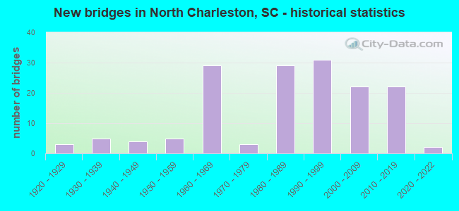
- New bridges - historical statistics
- 31920-1929
- 51930-1939
- 41940-1949
- 51950-1959
- 291960-1969
- 31970-1979
- 291980-1989
- 311990-1999
- 222000-2009
- 222010-2019
- 22020-2022
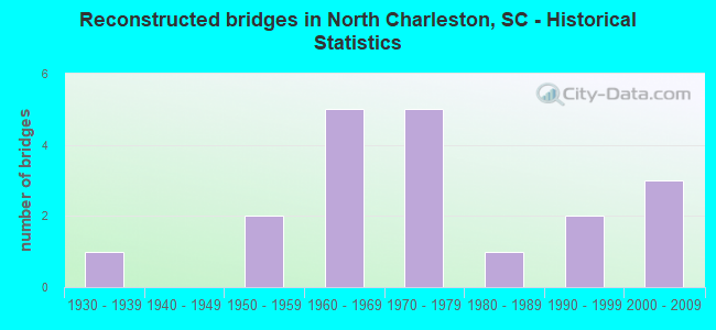
- Reconstructed bridges - Historical Statistics
- 11930-1939
- 01940-1949
- 21950-1959
- 51960-1969
- 51970-1979
- 11980-1989
- 21990-1999
- 32000-2009
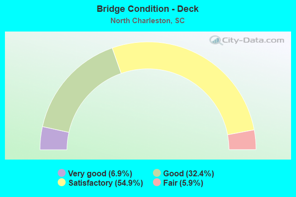
- Bridge Condition - Deck
- 6.9%Very good
- 32.4%Good
- 54.9%Satisfactory
- 5.9%Fair
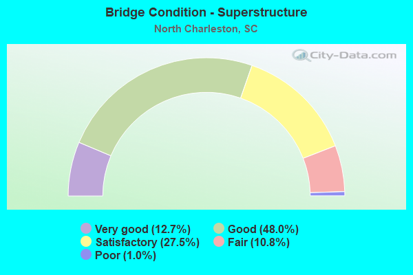
- Bridge Condition - Superstructure
- 12.7%Very good
- 48.0%Good
- 27.5%Satisfactory
- 10.8%Fair
- 1.0%Poor
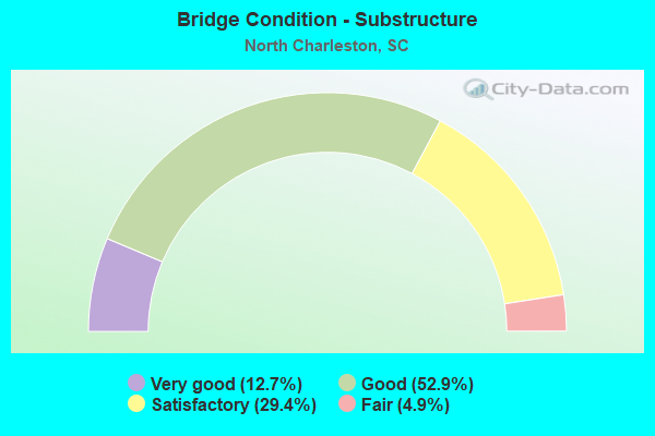
- Bridge Condition - Substructure
- 12.7%Very good
- 52.9%Good
- 29.4%Satisfactory
- 4.9%Fair
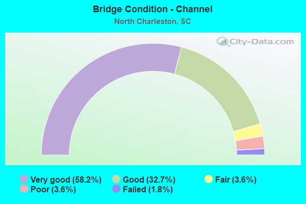
- Bridge Condition - Channel
- 58.2%Very good
- 32.7%Good
- 3.6%Fair
- 3.6%Poor
- 1.8%Failed
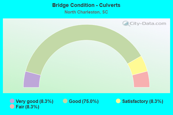
- Bridge Condition - Culverts
- 8.3%Very good
- 75.0%Good
- 8.3%Satisfactory
- 8.3%Fair
Find on map >> Show street view
Structure Number: 4063, Location: IN N CHARLESTON (Lat: 32.915556, Lng: -80.031189), Route carried "on" structure: State highway 195, Year Built: 1963, Status: Open, Structure Length: 7.86m (25.79ft), Average Daily Traffic: 2,600 (year 2020), Truck Traffic: 5%, Average Future Daily Traffic: 3,562 (year 2040), Design Load: HS 20, Features Intersected: I-26
Minimum Vertical Clearance: 5.59m (18.34ft), Kilometerpoint: 0.958, Lanes on structure: 2, Lanes under structure: 8, Owner: State Highway Agency, Approaching Roadway Width: 7.0m (23.0ft), Skew: 1 degrees, Material/Design: Prestressed concrete, Design/Construction: Stringer/Multi-beam, Number Of Spans In Main Unit: 4, Length of Maximum Span: 21.9m (71.9ft), Curb or Sidewalk Widths: Left: 1.5m (4.9ft), Right: 1.5m (4.9ft), Curb-To-Curb Width: 8.5m (27.9ft), Out-to-Out Width: 12.4m (40.7ft)
Condition: Deck: Satisfactory, Superstructure: Fair, Substructure: Good, Operating Rating: 56.1 metric tons, Method Used To Determine Operating Rating: Load and Resistance Factor Rating (LRFR) rating reported by rating factor(RF) method using HL-93 loadings, Inventory Rating: 27.2 metric tons, Method Used To Determine Inventory Rating: Load and Resistance Factor Rating (LRFR) rating reported by rating factor(RF) method using HL-93 loadings, Structural Evaluation: Somewhat better than minimum adequacy, Deck Geometry: Meets minimum limits, Underclear: High priority of corrective action, Approach Roadway Alignment: Equal to present desirable criteria, Length Of Structure Improvement: 7.86m (25.79ft), Designated Inspection Frequency: Every 24 months, Inspection Date: July 2021, Deck Structure Type: Concrete Cast-file-Place, Wearing Surface/Protective System: Wearing Surface: Monolithic Concrete
Find on map >> Show street view
Structure Number: 4064, Location: IN CHARLESTON (Lat: 32.872094, Lng: -79.975447), Route carried "on" structure: State highway 379, Year Built: 2015, Status: Open, Structure Length: 19.20m (62.99ft), Average Daily Traffic: 1,600 (year 2020), Truck Traffic: 4%, Average Future Daily Traffic: 2,192 (year 2040), Design Load: HL 93, Features Intersected: NOISETTE CREEK
Minimum Vertical Clearance: 30+ m (98+ ft), Kilometerpoint: 1.373, Lanes on structure: 2, Owner: State Highway Agency, Approaching Roadway Width: 7.8m (25.6ft), Material/Design: Prestressed concrete, Design/Construction: Box Beam or Girders - Multiple, Number Of Spans In Main Unit: 9, Length of Maximum Span: 21.3m (69.9ft), Curb or Sidewalk Widths: Left: 0.0m, Right: 1.5m (4.9ft), Curb-To-Curb Width: 10.2m (33.5ft), Out-to-Out Width: 12.8m (42.0ft)
Condition: Deck: Very good, Superstructure: Very good, Substructure: Very good, Channel: Very good, Operating Rating: 60.9 metric tons, Method Used To Determine Operating Rating: Load and Resistance Factor Rating (LRFR) rating reported by rating factor(RF) method using HL-93 loadings, Inventory Rating: 33.4 metric tons, Method Used To Determine Inventory Rating: Load and Resistance Factor Rating (LRFR) rating reported by rating factor(RF) method using HL-93 loadings, Structural Evaluation: Equal to present desirable criteria, Deck Geometry: Somewhat better than minimum adequacy, Waterway Adequacy: Superior to present desirable criteria, Approach Roadway Alignment: Equal to present desirable criteria, Length Of Structure Improvement: 18.29m (60.01ft), Designated Inspection Frequency: Every 24 months, Inspection Date: July 2021, Deck Structure Type: Concrete Precast Panels, Wearing Surface/Protective System: Wearing Surface: Bituminous
Find on map >> Show street view
Structure Number: 4065, Location: NORTH CHARLESTON (Lat: 32.847233, Lng: -79.986956), Route carried "on" structure: State highway 894, Year Built: 1963, Year Reconstructed: 1971, Status: Open, Structure Length: 8.84m (29.00ft), Average Daily Traffic: 12,300 (year 2020), Truck Traffic: 6%, Average Future Daily Traffic: 16,851 (year 2040), Design Load: HS 20+Mod, Features Intersected: I-26 & S-2463/HARVEY AVE
Minimum Vertical Clearance: 6.15m (20.18ft), Kilometerpoint: 2.218, Lanes on structure: 4, Lanes under structure: 8, Owner: State Highway Agency, Approaching Roadway Width: 14.9m (48.9ft), Skew: 1 degrees, Material/Design: Prestressed concrete, Design/Construction: Stringer/Multi-beam, Number Of Spans In Main Unit: 5, Length of Maximum Span: 21.3m (69.9ft), Curb or Sidewalk Widths: Left: 1.2m (3.9ft), Right: 1.2m (3.9ft), Curb-To-Curb Width: 15.2m (49.9ft), Out-to-Out Width: 18.4m (60.4ft)
Condition: Deck: Satisfactory, Superstructure: Fair, Substructure: Fair, Operating Rating: 58.0 metric tons, Method Used To Determine Operating Rating: Load and Resistance Factor Rating (LRFR) rating reported by rating factor(RF) method using HL-93 loadings, Inventory Rating: 29.8 metric tons, Method Used To Determine Inventory Rating: Load and Resistance Factor Rating (LRFR) rating reported by rating factor(RF) method using HL-93 loadings, Structural Evaluation: Somewhat better than minimum adequacy, Deck Geometry: High priority of corrective action, Underclear: Somewhat better than minimum adequacy, Approach Roadway Alignment: Equal to present desirable criteria, Length Of Structure Improvement: 9.92m (32.55ft), Designated Inspection Frequency: Every 24 months, Inspection Date: July 2021, Bridge Improvement Cost: $197,000, Roadway Improvement Cost: $49,000, Total Project Cost: $296,000 ( Estimate for 2021), Deck Structure Type: Concrete Cast-file-Place, Wearing Surface/Protective System: Wearing Surface: Bituminous
Find on map >> Show street view
Structure Number: 4266, Location: IN N CHARLESTON (Lat: 32.892625, Lng: -80.018725), Route carried "on" structure: Interstate 26, Year Built: 1964, Year Reconstructed: 2012, Status: Open, Structure Length: 6.95m (22.80ft), Average Daily Traffic: 128,600 (year 2020), Truck Traffic: 9%, Average Future Daily Traffic: 198,044 (year 2040), Design Load: HS 20+Mod, Features Intersected: RR NS SPUR & TAYLOR ST
Minimum Vertical Clearance: 30+ m (98+ ft), Kilometerpoint: 341.057, Lanes on structure: 6, Lanes under structure: 2, Base Highway Network: Yes, Owner: State Highway Agency, Approaching Roadway Width: 20.1m (65.9ft), Skew: 30 degrees, Material/Design: Steel, Design/Construction: Stringer/Multi-beam, Number Of Spans In Main Unit: 4, Length of Maximum Span: 18.0m (59.1ft), Curb-To-Curb Width: 45.7m (149.9ft), Out-to-Out Width: 45.7m (149.9ft)
Condition: Deck: Fair, Superstructure: Satisfactory, Substructure: Satisfactory, Operating Rating: 47.6 metric tons, Method Used To Determine Operating Rating: Load and Resistance Factor Rating (LRFR) rating reported by rating factor(RF) method using HL-93 loadings, Inventory Rating: 36.6 metric tons, Method Used To Determine Inventory Rating: Load and Resistance Factor Rating (LRFR) rating reported by rating factor(RF) method using HL-93 loadings, Structural Evaluation: Equal to present minimum criteria, Deck Geometry: Superior to present desirable criteria, Underclear: Equal to present minimum criteria, Approach Roadway Alignment: Equal to present desirable criteria, Length Of Structure Improvement: 6.95m (22.80ft), Designated Inspection Frequency: Every 24 months, Inspection Date: July 2020, Deck Structure Type: Concrete Cast-file-Place, Wearing Surface/Protective System: Wearing Surface: Monolithic Concrete
Find on map >> Show street view
Structure Number: 4267, Location: 0.5 MI W N CHARLESTON (Lat: 32.888886, Lng: -80.019456), Route carried "on" structure: Interstate 26, Year Built: 1964, Year Reconstructed: 1990, Status: Open, Structure Length: 9.74m (31.96ft), Average Daily Traffic: 64,300 (year 2020), Truck Traffic: 9%, Average Future Daily Traffic: 99,022 (year 2040), Design Load: HS 20+Mod, Features Intersected: S-1600 & RR NS
Minimum Vertical Clearance: 30+ m (98+ ft), Kilometerpoint: 341.464, Lanes on structure: 3, Lanes under structure: 2, Base Highway Network: Yes, Owner: State Highway Agency, Approaching Roadway Width: 25.8m (84.6ft), Skew: 34 degrees, Material/Design: Steel, Design/Construction: Stringer/Multi-beam, Number Of Spans In Main Unit: 2, Number Of Approach Spans: 2, Length of Maximum Span: 29.9m (98.1ft), Curb-To-Curb Width: 44.6m (146.3ft), Out-to-Out Width: 45.7m (149.9ft)
Condition: Deck: Satisfactory, Superstructure: Fair, Substructure: Satisfactory, Operating Rating: 51.8 metric tons, Method Used To Determine Operating Rating: Load and Resistance Factor Rating (LRFR) rating reported by rating factor(RF) method using HL-93 loadings, Inventory Rating: 39.9 metric tons, Method Used To Determine Inventory Rating: Load and Resistance Factor Rating (LRFR) rating reported by rating factor(RF) method using HL-93 loadings, Structural Evaluation: Somewhat better than minimum adequacy, Deck Geometry: Superior to present desirable criteria, Underclear: Meets minimum limits, Approach Roadway Alignment: Equal to present desirable criteria, Length Of Structure Improvement: 10.80m (35.43ft), Designated Inspection Frequency: Every 24 months, Inspection Date: August 2020, Deck Structure Type: Concrete Cast-file-Place, Wearing Surface/Protective System: Wearing Surface: Monolithic Concrete
Find on map >> Show street view
Structure Number: 4268, Location: IN N CHARLESTON (Lat: 32.843539, Lng: -79.980581), Route carried "on" structure: Interstate 26, Year Built: 1964, Status: Open, Structure Length: 14.30m (46.92ft), Average Daily Traffic: 80,500 (year 2020), Truck Traffic: 9%, Average Future Daily Traffic: 123,970 (year 2040), Design Load: HS 20, Features Intersected: S.C 7/COSGROVE AVE
Minimum Vertical Clearance: 4.72m (15.49ft), Kilometerpoint: 348.096, Lanes on structure: 6, Lanes under structure: 7, Base Highway Network: Yes, Owner: State Highway Agency, Approaching Roadway Width: 17.7m (58.1ft), Skew: 30 degrees, Material/Design: Steel, Design/Construction: Stringer/Multi-beam, Number Of Spans In Main Unit: 1, Number Of Approach Spans: 8, Length of Maximum Span: 28.3m (92.8ft), Curb or Sidewalk Widths: Left: 0.5m (1.6ft), Right: 0.5m (1.6ft), Curb-To-Curb Width: 34.1m (111.9ft), Out-to-Out Width: 35.8m (117.5ft)
Condition: Deck: Fair, Superstructure: Fair, Substructure: Satisfactory, Operating Rating: 47.3 metric tons, Method Used To Determine Operating Rating: Load and Resistance Factor Rating (LRFR) rating reported by rating factor(RF) method using HL-93 loadings, Inventory Rating: 30.5 metric tons, Method Used To Determine Inventory Rating: Load and Resistance Factor Rating (LRFR) rating reported by rating factor(RF) method using HL-93 loadings, Structural Evaluation: Somewhat better than minimum adequacy, Deck Geometry: Superior to present desirable criteria, Underclear: High priority of corrective action, Approach Roadway Alignment: Equal to present desirable criteria, Length Of Structure Improvement: 15.13m (49.64ft), Designated Inspection Frequency: Every 24 months, Other Special Inspection Frequency: Every 12 months, Inspection Date: August 2020, Other Special Inspection Date: August 2021, Deck Structure Type: Concrete Cast-file-Place, Wearing Surface/Protective System: Wearing Surface: Monolithic Concrete
Find on map >> Show street view
Structure Number: 4269, Location: IN N CHARLESTON (Lat: 32.841703, Lng: -79.969194), Route carried "on" structure: Interstate 26, Year Built: 1964, Status: Open, Structure Length: 10.06m (33.01ft), Average Daily Traffic: 77,100 (year 2020), Truck Traffic: 9%, Average Future Daily Traffic: 118,734 (year 2040), Design Load: HS 20, Features Intersected: S-222/BAKER HOSPITAL
Minimum Vertical Clearance: 30+ m (98+ ft), Kilometerpoint: 349.186, Lanes on structure: 6, Lanes under structure: 2, Base Highway Network: Yes, Owner: State Highway Agency, Approaching Roadway Width: 31.8m (104.3ft), Skew: 30 degrees, Material/Design: Steel, Design/Construction: Stringer/Multi-beam, Number Of Spans In Main Unit: 5, Length of Maximum Span: 33.5m (109.9ft), Curb-To-Curb Width: 26.2m (86.0ft), Out-to-Out Width: 31.0m (101.7ft)
Condition: Deck: Fair, Superstructure: Satisfactory, Substructure: Satisfactory, Operating Rating: 58.6 metric tons, Method Used To Determine Operating Rating: Load and Resistance Factor Rating (LRFR) rating reported by rating factor(RF) method using HL-93 loadings, Inventory Rating: 45.4 metric tons, Method Used To Determine Inventory Rating: Load and Resistance Factor Rating (LRFR) rating reported by rating factor(RF) method using HL-93 loadings, Structural Evaluation: Equal to present minimum criteria, Deck Geometry: Meets minimum limits, Underclear: Somewhat better than minimum adequacy, Approach Roadway Alignment: Equal to present desirable criteria, Length Of Structure Improvement: 10.06m (33.01ft), Designated Inspection Frequency: Every 24 months, Inspection Date: August 2020, Deck Structure Type: Concrete Cast-file-Place, Wearing Surface/Protective System: Wearing Surface: Monolithic Concrete
Find on map >> Show street view
Structure Number: 427, Location: 1 MI W N CHARLESTON (Lat: 32.920792, Lng: -80.037381), Route carried "on" structure: Interstate 26, Year Built: 1964, Year Reconstructed: 2012, Status: Open, Structure Length: 5.57m (18.27ft), Average Daily Traffic: 61,750 (year 2020), Truck Traffic: 9%, Average Future Daily Traffic: 95,095 (year 2040), Design Load: HS 20, Features Intersected: MIDLAND PARK RD.-S-1187
Minimum Vertical Clearance: 30+ m (98+ ft), Kilometerpoint: 337.420, Lanes on structure: 3, Lanes under structure: 2, Base Highway Network: Yes, Owner: State Highway Agency, Approaching Roadway Width: 18.3m (60.0ft), Skew: 34 degrees, Material/Design: Steel, Design/Construction: Stringer/Multi-beam, Number Of Spans In Main Unit: 3, Length of Maximum Span: 25.0m (82.0ft), Curb-To-Curb Width: 38.3m (125.7ft), Out-to-Out Width: 39.9m (130.9ft)
Condition: Deck: Satisfactory, Superstructure: Satisfactory, Substructure: Satisfactory, Operating Rating: 46.3 metric tons, Method Used To Determine Operating Rating: Load and Resistance Factor Rating (LRFR) rating reported by rating factor(RF) method using HL-93 loadings, Inventory Rating: 35.6 metric tons, Method Used To Determine Inventory Rating: Load and Resistance Factor Rating (LRFR) rating reported by rating factor(RF) method using HL-93 loadings, Structural Evaluation: Equal to present minimum criteria, Deck Geometry: Superior to present desirable criteria, Underclear: Meets minimum limits, Approach Roadway Alignment: Equal to present desirable criteria, Length Of Structure Improvement: 5.57m (18.27ft), Designated Inspection Frequency: Every 24 months, Inspection Date: July 2020, Deck Structure Type: Concrete Cast-file-Place, Wearing Surface/Protective System: Wearing Surface: Monolithic Concrete
Find on map >> Show street view
Structure Number: 4477, Location: IN N CHARLESTON (Lat: 32.889664, Lng: -80.011439), Route carried "on" structure: US 52, Year Built: 1965, Status: Open, Structure Length: 1.37m (4.49ft), Average Daily Traffic: 13,250 (year 2020), Truck Traffic: 8%, Average Future Daily Traffic: 18,948 (year 2040), Design Load: H 15, Features Intersected: FILBIN CREEK
Minimum Vertical Clearance: 30+ m (98+ ft), Kilometerpoint: 13.119, Lanes on structure: 3, Base Highway Network: Yes, Owner: State Highway Agency, Approaching Roadway Width: 15.6m (51.2ft), Material/Design: Concrete, Design/Construction: Slab, Number Of Spans In Main Unit: 3, Length of Maximum Span: 4.6m (15.1ft), Curb or Sidewalk Widths: Left: 0.0m, Right: 0.9m (3.0ft), Curb-To-Curb Width: 17.4m (57.1ft), Out-to-Out Width: 18.7m (61.4ft)
Condition: Deck: Satisfactory, Superstructure: Satisfactory, Substructure: Satisfactory, Channel: Poor, Operating Rating: 29.2 metric tons, Method Used To Determine Operating Rating: Load and Resistance Factor Rating (LRFR) rating reported by rating factor(RF) method using HL-93 loadings, Inventory Rating: 22.7 metric tons, Method Used To Determine Inventory Rating: Load and Resistance Factor Rating (LRFR) rating reported by rating factor(RF) method using HL-93 loadings, Structural Evaluation: Somewhat better than minimum adequacy, Deck Geometry: Superior to present desirable criteria, Waterway Adequacy: Equal to present minimum criteria, Approach Roadway Alignment: Equal to present desirable criteria, Length Of Structure Improvement: 1.37m (4.49ft), Designated Inspection Frequency: Every 24 months, Inspection Date: August 2020, Deck Structure Type: Concrete Precast Panels, Wearing Surface/Protective System: Wearing Surface: Bituminous
Find on map >> Show street view
Structure Number: 5904, Location: NORTH CHARLESTON (Lat: 32.846461, Lng: -79.977508), Route carried "on" structure: State highway 894, Year Built: 1971, Status: Open, Structure Length: 0.91m (2.99ft), Average Daily Traffic: 9,100 (year 2020), Truck Traffic: 12%, Average Future Daily Traffic: 12,467 (year 2040), Design Load: HS 20, Features Intersected: NOISETTE CREEK
Minimum Vertical Clearance: 30+ m (98+ ft), Kilometerpoint: 1.324, Lanes on structure: 4, Owner: State Highway Agency, Approaching Roadway Width: 13.6m (44.6ft), Material/Design: Concrete, Design/Construction: Slab, Number Of Spans In Main Unit: 1, Length of Maximum Span: 9.1m (29.9ft), Curb-To-Curb Width: 20.7m (67.9ft), Out-to-Out Width: 21.9m (71.9ft)
Condition: Deck: Satisfactory, Superstructure: Satisfactory, Substructure: Satisfactory, Channel: Good, Operating Rating: 43.7 metric tons, Method Used To Determine Operating Rating: Load and Resistance Factor Rating (LRFR) rating reported by rating factor(RF) method using HL-93 loadings, Inventory Rating: 33.7 metric tons, Method Used To Determine Inventory Rating: Load and Resistance Factor Rating (LRFR) rating reported by rating factor(RF) method using HL-93 loadings, Structural Evaluation: Equal to present minimum criteria, Deck Geometry: Superior to present desirable criteria, Waterway Adequacy: Equal to present desirable criteria, Approach Roadway Alignment: Equal to present desirable criteria, Length Of Structure Improvement: 0.91m (2.99ft), Designated Inspection Frequency: Every 24 months, Inspection Date: July 2021, Deck Structure Type: Concrete Cast-file-Place, Wearing Surface/Protective System: Wearing Surface: Monolithic Concrete
Find on map >> Show street view
Structure Number: 5905, Location: 13.7 MI N CHARLESTON (Lat: 32.971328, Lng: -80.054244), Route carried "on" structure: State highway 1624, Year Built: 1971, Status: Open, Structure Length: 0.91m (2.99ft), Average Daily Traffic: 250 (year 2020), Truck Traffic: 5%, Average Future Daily Traffic: 320 (year 2040), Design Load: H 10, Features Intersected: UNNAMED STREAM
Minimum Vertical Clearance: 30+ m (98+ ft), Kilometerpoint: 0.388, Lanes on structure: 2, Owner: State Highway Agency, Approaching Roadway Width: 5.8m (19.0ft), Material/Design: Concrete, Design/Construction: Slab, Number Of Spans In Main Unit: 2, Length of Maximum Span: 4.6m (15.1ft), Curb or Sidewalk Widths: Left: 0.2m (0.7ft), Right: 0.2m (0.7ft), Curb-To-Curb Width: 7.9m (25.9ft), Out-to-Out Width: 8.4m (27.6ft)
Condition: Deck: Satisfactory, Superstructure: Satisfactory, Substructure: Satisfactory, Channel: Good, Operating Rating: 23.0 metric tons, Method Used To Determine Operating Rating: Load and Resistance Factor Rating (LRFR) rating reported by rating factor(RF) method using HL-93 loadings, Inventory Rating: 17.8 metric tons, Method Used To Determine Inventory Rating: Load and Resistance Factor Rating (LRFR) rating reported by rating factor(RF) method using HL-93 loadings, Structural Evaluation: Somewhat better than minimum adequacy, Deck Geometry: Somewhat better than minimum adequacy, Waterway Adequacy: Equal to present minimum criteria, Approach Roadway Alignment: Equal to present desirable criteria, Bridge Posting: Required (Relationship of Operating Rating to Maximum Legal Load: 20.0 - 29.9% below), Length Of Structure Improvement: 0.91m (2.99ft), Designated Inspection Frequency: Every 24 months, Inspection Date: June 2021, Deck Structure Type: Concrete Precast Panels, Wearing Surface/Protective System: Wearing Surface: Bituminous
Find on map >> Show street view
Structure Number: 6052, Location: 1.0 MI SE LADSON (Lat: 32.980381, Lng: -80.082808), Route carried "on" structure: US 78, Year Built: 2001, Status: Open, Structure Length: 1.74m (5.71ft), Average Daily Traffic: 50,000 (year 2020), Truck Traffic: 4%, Average Future Daily Traffic: 71,500 (year 2040), Design Load: HS 20, Features Intersected: POPPERDAM CREEK
Minimum Vertical Clearance: 30+ m (98+ ft), Kilometerpoint: 8.742, Lanes on structure: 4, Base Highway Network: Yes, Owner: State Highway Agency, Approaching Roadway Width: 19.8m (65.0ft), Material/Design: Prestressed concrete, Design/Construction: Stringer/Multi-beam, Number Of Spans In Main Unit: 1, Length of Maximum Span: 17.4m (57.1ft), Curb or Sidewalk Widths: Left: 1.5m (4.9ft), Right: 1.5m (4.9ft), Curb-To-Curb Width: 19.8m (65.0ft), Out-to-Out Width: 23.5m (77.1ft)
Condition: Deck: Satisfactory, Superstructure: Good, Substructure: Good, Channel: Good, Operating Rating: 25.3 metric tons, Method Used To Determine Operating Rating: Load and Resistance Factor Rating (LRFR) rating reported by rating factor(RF) method using HL-93 loadings, Inventory Rating: 12.6 metric tons, Method Used To Determine Inventory Rating: Load and Resistance Factor Rating (LRFR) rating reported by rating factor(RF) method using HL-93 loadings, Structural Evaluation: High priority of corrective action, Deck Geometry: Better than present minimum criteria, Waterway Adequacy: Equal to present minimum criteria, Approach Roadway Alignment: Equal to present desirable criteria, Length Of Structure Improvement: 2.46m (8.07ft), Designated Inspection Frequency: Every 24 months, Inspection Date: June 2020, Bridge Improvement Cost: $12,000, Roadway Improvement Cost: $3,000, Total Project Cost: $18,000 ( Estimate for 2021), Deck Structure Type: Concrete Cast-file-Place, Wearing Surface/Protective System: Wearing Surface: Monolithic Concrete
Find on map >> Show street view
Structure Number: 6631, Location: IN N CHAS (Lat: 32.928317, Lng: -80.075547), Route carried "on" structure: State highway 75, Year Built: 1975, Year Reconstructed: 2004, Status: Open, Structure Length: 0.82m (2.69ft), Average Daily Traffic: 38,800 (year 2020), Truck Traffic: 11%, Average Future Daily Traffic: 47,336 (year 2040), Design Load: HS 20, Features Intersected: POPPERDAM CREEK
Minimum Vertical Clearance: 30+ m (98+ ft), Kilometerpoint: 3.563, Lanes on structure: 6, Owner: State Highway Agency, Approaching Roadway Width: 27.1m (88.9ft), Material/Design: Concrete, Design/Construction: Culvert, Number Of Spans In Main Unit: 3, Length of Maximum Span: 2.4m (7.9ft), Curb-To-Curb Width: 27.1m (88.9ft), Out-to-Out Width: 38.7m (127.0ft)
Condition: Channel: Very good, Culverts: Good, Operating Rating: 49.9 metric tons, Method Used To Determine Operating Rating: Load and Resistance Factor Rating (LRFR) rating reported by rating factor(RF) method using HL-93 loadings, Inventory Rating: 38.6 metric tons, Method Used To Determine Inventory Rating: Load and Resistance Factor Rating (LRFR) rating reported by rating factor(RF) method using HL-93 loadings, Structural Evaluation: Better than present minimum criteria, Deck Geometry: Better than present minimum criteria, Waterway Adequacy: Equal to present minimum criteria, Approach Roadway Alignment: Equal to present desirable criteria, Length Of Structure Improvement: 0.82m (2.69ft), Designated Inspection Frequency: Every 24 months, Inspection Date: July 2021
Find on map >> Show street view
Structure Number: 7328, Location: IN N CHARLESTON (Lat: 32.873561, Lng: -80.012131), Route carried "on" structure: Ramp Interstate 26, Year Built: 1980, Status: Open, Structure Length: 6.98m (22.90ft), Average Daily Traffic: 2,800 (year 2020), Truck Traffic: 9%, Average Future Daily Traffic: 6,524 (year 2040), Design Load: HS 20+Mod, Features Intersected: MALL RD ACCESS
Minimum Vertical Clearance: 30+ m (98+ ft), Kilometerpoint: 342.765, Lanes on structure: 2, Lanes under structure: 2, Owner: State Highway Agency, Approaching Roadway Width: 9.8m (32.2ft), Skew: 5 degrees, Material/Design: Steel, Design/Construction: Stringer/Multi-beam, Number Of Spans In Main Unit: 3, Length of Maximum Span: 34.1m (111.9ft), Curb-To-Curb Width: 9.8m (32.2ft), Out-to-Out Width: 10.8m (35.4ft)
Condition: Deck: Satisfactory, Superstructure: Good, Substructure: Good, Operating Rating: 55.4 metric tons, Method Used To Determine Operating Rating: Load and Resistance Factor Rating (LRFR) rating reported by rating factor(RF) method using HL-93 loadings, Inventory Rating: 42.8 metric tons, Method Used To Determine Inventory Rating: Load and Resistance Factor Rating (LRFR) rating reported by rating factor(RF) method using HL-93 loadings, Structural Evaluation: Better than present minimum criteria, Deck Geometry: Equal to present minimum criteria, Underclear: Superior to present desirable criteria, Approach Roadway Alignment: Equal to present desirable criteria, Length Of Structure Improvement: 6.98m (22.90ft), Designated Inspection Frequency: Every 24 months, Inspection Date: July 2020, Deck Structure Type: Concrete Cast-file-Place, Wearing Surface/Protective System: Wearing Surface: Monolithic Concrete
Find on map >> Show street view
Structure Number: 7332, Location: AT N CHARLESTON (Lat: 32.842008, Lng: -80.018717), Route carried "on" structure: State highway 475, Year Built: 1980, Status: Open, Structure Length: 7.62m (25.00ft), Average Daily Traffic: 8,600 (year 2020), Truck Traffic: 4%, Average Future Daily Traffic: 11,782 (year 2040), Design Load: HS 20, Features Intersected: I-526 MARK CLARK EXPWY
Minimum Vertical Clearance: 6.55m (21.49ft), Kilometerpoint: 0.378, Lanes on structure: 4, Lanes under structure: 4, Owner: State Highway Agency, Approaching Roadway Width: 21.9m (71.9ft), Material/Design: Steel continuous, Design/Construction: Stringer/Multi-beam, Number Of Spans In Main Unit: 4, Length of Maximum Span: 26.2m (86.0ft), Curb-To-Curb Width: 22.6m (74.1ft), Out-to-Out Width: 23.6m (77.4ft)
Condition: Deck: Satisfactory, Superstructure: Satisfactory, Substructure: Good, Operating Rating: 46.3 metric tons, Method Used To Determine Operating Rating: Load and Resistance Factor Rating (LRFR) rating reported by rating factor(RF) method using HL-93 loadings, Inventory Rating: 35.6 metric tons, Method Used To Determine Inventory Rating: Load and Resistance Factor Rating (LRFR) rating reported by rating factor(RF) method using HL-93 loadings, Structural Evaluation: Equal to present minimum criteria, Deck Geometry: Superior to present desirable criteria, Underclear: Equal to present minimum criteria, Approach Roadway Alignment: Equal to present desirable criteria, Length Of Structure Improvement: 7.62m (25.00ft), Designated Inspection Frequency: Every 24 months, Inspection Date: July 2021, Deck Structure Type: Concrete Cast-file-Place, Wearing Surface/Protective System: Wearing Surface: Monolithic Concrete
Find on map >> Show street view
Structure Number: 7968, Location: IN N CHARLESTON (Lat: 32.852697, Lng: -80.020167), Route carried "on" structure: Interstate 526, Year Built: 1986, Status: Open, Structure Length: 4.75m (15.58ft), Average Daily Traffic: 35,400 (year 2020), Truck Traffic: 9%, Average Future Daily Traffic: 54,516 (year 2040), Design Load: HS 20, Features Intersected: S-771 PARMOUNT ST
Minimum Vertical Clearance: 30+ m (98+ ft), Kilometerpoint: 23.635, Lanes on structure: 2, Lanes under structure: 6, Base Highway Network: Yes, Owner: State Highway Agency, Approaching Roadway Width: 11.3m (37.1ft), Material/Design: Steel, Design/Construction: Stringer/Multi-beam, Number Of Spans In Main Unit: 3, Length of Maximum Span: 29.6m (97.1ft), Curb-To-Curb Width: 12.1m (39.7ft), Out-to-Out Width: 13.0m (42.7ft)
Condition: Deck: Good, Superstructure: Good, Substructure: Good, Operating Rating: 43.1 metric tons, Method Used To Determine Operating Rating: Load and Resistance Factor Rating (LRFR) rating reported by rating factor(RF) method using HL-93 loadings, Inventory Rating: 33.4 metric tons, Method Used To Determine Inventory Rating: Load and Resistance Factor Rating (LRFR) rating reported by rating factor(RF) method using HL-93 loadings, Structural Evaluation: Better than present minimum criteria, Deck Geometry: Equal to present minimum criteria, Underclear: Equal to present minimum criteria, Approach Roadway Alignment: Equal to present desirable criteria, Length Of Structure Improvement: 4.75m (15.58ft), Designated Inspection Frequency: Every 24 months, Inspection Date: June 2020, Deck Structure Type: Concrete Cast-file-Place, Wearing Surface/Protective System: Wearing Surface: Monolithic Concrete
Find on map >> Show street view
Structure Number: 7969, Location: IN N CHARLESTON (Lat: 32.854594, Lng: -80.021197), Route carried "on" structure: Interstate 526, Year Built: 1986, Status: Open, Structure Length: 7.07m (23.20ft), Average Daily Traffic: 35,850 (year 2020), Truck Traffic: 9%, Average Future Daily Traffic: 55,209 (year 2040), Design Load: HS 20, Features Intersected: SC 642
Minimum Vertical Clearance: 6.35m (20.83ft), Kilometerpoint: 23.855, Lanes on structure: 2, Lanes under structure: 6, Base Highway Network: Yes, Owner: State Highway Agency, Approaching Roadway Width: 11.2m (36.7ft), Skew: 3 degrees, Material/Design: Steel, Design/Construction: Stringer/Multi-beam, Number Of Spans In Main Unit: 3, Length of Maximum Span: 38.7m (127.0ft), Curb-To-Curb Width: 12.0m (39.4ft), Out-to-Out Width: 13.0m (42.7ft)
Condition: Deck: Satisfactory, Superstructure: Good, Substructure: Good, Operating Rating: 46.0 metric tons, Method Used To Determine Operating Rating: Load and Resistance Factor Rating (LRFR) rating reported by rating factor(RF) method using HL-93 loadings, Inventory Rating: 35.3 metric tons, Method Used To Determine Inventory Rating: Load and Resistance Factor Rating (LRFR) rating reported by rating factor(RF) method using HL-93 loadings, Structural Evaluation: Better than present minimum criteria, Deck Geometry: Equal to present minimum criteria, Underclear: Meets minimum limits, Approach Roadway Alignment: Equal to present desirable criteria, Length Of Structure Improvement: 7.07m (23.20ft), Designated Inspection Frequency: Every 24 months, Inspection Date: December 2020, Deck Structure Type: Concrete Cast-file-Place, Wearing Surface/Protective System: Wearing Surface: Monolithic Concrete
Find on map >> Show street view
Structure Number: 797, Location: IN N CHARLESTON (Lat: 32.857022, Lng: -80.022514), Route carried "on" structure: Interstate 526, Year Built: 1986, Status: Open, Structure Length: 7.10m (23.29ft), Average Daily Traffic: 35,850 (year 2020), Truck Traffic: 9%, Average Future Daily Traffic: 55,209 (year 2040), Design Load: HS 20, Features Intersected: SCLRR
Minimum Vertical Clearance: 30+ m (98+ ft), Kilometerpoint: 24.151, Lanes on structure: 2, Base Highway Network: Yes, Owner: State Highway Agency, Approaching Roadway Width: 14.8m (48.6ft), Material/Design: Steel continuous, Design/Construction: Stringer/Multi-beam, Number Of Spans In Main Unit: 3, Length of Maximum Span: 32.6m (107.0ft), Curb-To-Curb Width: 15.7m (51.5ft), Out-to-Out Width: 16.7m (54.8ft)
Condition: Deck: Satisfactory, Superstructure: Good, Substructure: Good, Operating Rating: 36.0 metric tons, Method Used To Determine Operating Rating: Load and Resistance Factor Rating (LRFR) rating reported by rating factor(RF) method using HL-93 loadings, Inventory Rating: 26.6 metric tons, Method Used To Determine Inventory Rating: Load and Resistance Factor Rating (LRFR) rating reported by rating factor(RF) method using HL-93 loadings, Structural Evaluation: Equal to present minimum criteria, Deck Geometry: Superior to present desirable criteria, Underclear: Somewhat better than minimum adequacy, Approach Roadway Alignment: Equal to present desirable criteria, Length Of Structure Improvement: 7.10m (23.29ft), Designated Inspection Frequency: Every 24 months, Inspection Date: December 2020, Deck Structure Type: Concrete Cast-file-Place, Wearing Surface/Protective System: Wearing Surface: Monolithic Concrete
Find on map >> Show street view
Structure Number: 7971, Location: IN N CHARLESTON (Lat: 32.862975, Lng: -80.025742), Route carried "on" structure: Interstate 526, Year Built: 1986, Status: Open, Structure Length: 5.61m (18.41ft), Average Daily Traffic: 35,850 (year 2020), Truck Traffic: 9%, Average Future Daily Traffic: 55,209 (year 2040), Design Load: HS 20, Features Intersected: S-62 MONTAGUE AVE
Minimum Vertical Clearance: 5.79m (19.00ft), Kilometerpoint: 24.861, Lanes on structure: 2, Lanes under structure: 6, Base Highway Network: Yes, Owner: State Highway Agency, Approaching Roadway Width: 10.9m (35.8ft), Skew: 1 degrees, Material/Design: Steel, Design/Construction: Stringer/Multi-beam, Number Of Spans In Main Unit: 3, Length of Maximum Span: 32.3m (106.0ft), Curb-To-Curb Width: 12.0m (39.4ft), Out-to-Out Width: 13.0m (42.7ft)
Condition: Deck: Satisfactory, Superstructure: Good, Substructure: Good, Operating Rating: 65.4 metric tons, Method Used To Determine Operating Rating: Load and Resistance Factor Rating (LRFR) rating reported by rating factor(RF) method using HL-93 loadings, Inventory Rating: 50.5 metric tons, Method Used To Determine Inventory Rating: Load and Resistance Factor Rating (LRFR) rating reported by rating factor(RF) method using HL-93 loadings, Structural Evaluation: Better than present minimum criteria, Deck Geometry: Equal to present minimum criteria, Underclear: Meets minimum limits, Approach Roadway Alignment: Equal to present desirable criteria, Length Of Structure Improvement: 5.61m (18.41ft), Designated Inspection Frequency: Every 24 months, Inspection Date: December 2020, Deck Structure Type: Concrete Cast-file-Place, Wearing Surface/Protective System: Wearing Surface: Monolithic Concrete
Find on map >> Show street view
Structure Number: 7972, Location: IN N CHARLESTON (Lat: 32.868872, Lng: -80.027094), Route carried "on" structure: Interstate 526, Year Built: 1986, Status: Open, Structure Length: 6.95m (22.80ft), Average Daily Traffic: 42,900 (year 2020), Truck Traffic: 9%, Average Future Daily Traffic: 66,066 (year 2040), Design Load: HS 20, Features Intersected: AIRPORT ACCESS__L-4486
Minimum Vertical Clearance: 5.33m (17.49ft), Kilometerpoint: 25.556, Lanes on structure: 2, Lanes under structure: 7, Base Highway Network: Yes, Owner: State Highway Agency, Approaching Roadway Width: 14.5m (47.6ft), Material/Design: Steel continuous, Design/Construction: Stringer/Multi-beam, Number Of Spans In Main Unit: 4, Length of Maximum Span: 22.6m (74.1ft), Curb-To-Curb Width: 14.5m (47.6ft), Out-to-Out Width: 15.3m (50.2ft)
Condition: Deck: Satisfactory, Superstructure: Good, Substructure: Good, Operating Rating: 32.1 metric tons, Method Used To Determine Operating Rating: Load and Resistance Factor Rating (LRFR) rating reported by rating factor(RF) method using HL-93 loadings, Inventory Rating: 24.6 metric tons, Method Used To Determine Inventory Rating: Load and Resistance Factor Rating (LRFR) rating reported by rating factor(RF) method using HL-93 loadings, Structural Evaluation: Equal to present minimum criteria, Deck Geometry: Superior to present desirable criteria, Underclear: Equal to present minimum criteria, Approach Roadway Alignment: Equal to present desirable criteria, Length Of Structure Improvement: 6.95m (22.80ft), Designated Inspection Frequency: Every 24 months, Inspection Date: December 2020, Deck Structure Type: Concrete Cast-file-Place, Wearing Surface/Protective System: Wearing Surface: Monolithic Concrete
Find on map >> Show street view
Structure Number: 7974, Location: IN N CHARLESTON (Lat: 32.854581, Lng: -80.021508), Route carried "on" structure: Interstate 526, Year Built: 1986, Status: Open, Structure Length: 7.07m (23.20ft), Average Daily Traffic: 35,400 (year 2020), Truck Traffic: 9%, Average Future Daily Traffic: 54,516 (year 2040), Design Load: HS 20, Features Intersected: SC 642
Minimum Vertical Clearance: 6.40m (21.00ft), Kilometerpoint: 23.812, Lanes on structure: 2, Lanes under structure: 6, Base Highway Network: Yes, Owner: State Highway Agency, Approaching Roadway Width: 12.0m (39.4ft), Skew: 3 degrees, Material/Design: Steel, Design/Construction: Stringer/Multi-beam, Number Of Spans In Main Unit: 3, Length of Maximum Span: 38.7m (127.0ft), Curb-To-Curb Width: 12.0m (39.4ft), Out-to-Out Width: 13.0m (42.7ft)
Condition: Deck: Satisfactory, Superstructure: Good, Substructure: Good, Operating Rating: 46.3 metric tons, Method Used To Determine Operating Rating: Load and Resistance Factor Rating (LRFR) rating reported by rating factor(RF) method using HL-93 loadings, Inventory Rating: 35.6 metric tons, Method Used To Determine Inventory Rating: Load and Resistance Factor Rating (LRFR) rating reported by rating factor(RF) method using HL-93 loadings, Structural Evaluation: Better than present minimum criteria, Deck Geometry: Equal to present minimum criteria, Underclear: Meets minimum limits, Approach Roadway Alignment: Equal to present desirable criteria, Length Of Structure Improvement: 7.07m (23.20ft), Designated Inspection Frequency: Every 24 months, Inspection Date: December 2020, Deck Structure Type: Concrete Cast-file-Place, Wearing Surface/Protective System: Wearing Surface: Monolithic Concrete
Find on map >> Show street view
Structure Number: 7975, Location: IN N CHARLESTON (Lat: 32.856875, Lng: -80.022775), Route carried "on" structure: Interstate 526, Year Built: 1986, Status: Open, Structure Length: 7.10m (23.29ft), Average Daily Traffic: 35,850 (year 2020), Truck Traffic: 9%, Average Future Daily Traffic: 55,209 (year 2040), Design Load: HS 20, Features Intersected: SCLRR
Minimum Vertical Clearance: 30+ m (98+ ft), Kilometerpoint: 24.092, Lanes on structure: 2, Base Highway Network: Yes, Owner: State Highway Agency, Approaching Roadway Width: 10.5m (34.4ft), Material/Design: Steel continuous, Design/Construction: Stringer/Multi-beam, Number Of Spans In Main Unit: 3, Length of Maximum Span: 32.6m (107.0ft), Curb-To-Curb Width: 12.0m (39.4ft), Out-to-Out Width: 13.0m (42.7ft)
Condition: Deck: Satisfactory, Superstructure: Good, Substructure: Good, Operating Rating: 28.8 metric tons, Method Used To Determine Operating Rating: Load and Resistance Factor Rating (LRFR) rating reported by rating factor(RF) method using HL-93 loadings, Inventory Rating: 22.0 metric tons, Method Used To Determine Inventory Rating: Load and Resistance Factor Rating (LRFR) rating reported by rating factor(RF) method using HL-93 loadings, Structural Evaluation: Somewhat better than minimum adequacy, Deck Geometry: Equal to present minimum criteria, Underclear: Somewhat better than minimum adequacy, Approach Roadway Alignment: Equal to present desirable criteria, Length Of Structure Improvement: 7.10m (23.29ft), Designated Inspection Frequency: Every 24 months, Inspection Date: December 2020, Deck Structure Type: Concrete Cast-file-Place, Wearing Surface/Protective System: Wearing Surface: Monolithic Concrete
Find on map >> Show street view
Structure Number: 7977, Location: IN N CHARLESTON (Lat: 32.862664, Lng: -80.025900), Route carried "on" structure: Interstate 526, Year Built: 1986, Status: Open, Structure Length: 5.61m (18.41ft), Average Daily Traffic: 35,850 (year 2020), Truck Traffic: 9%, Average Future Daily Traffic: 55,209 (year 2040), Design Load: HS 20, Features Intersected: S-62 MONTAGUE AVE
Minimum Vertical Clearance: 5.41m (17.75ft), Kilometerpoint: 24.806, Lanes on structure: 2, Lanes under structure: 6, Base Highway Network: Yes, Owner: State Highway Agency, Approaching Roadway Width: 10.9m (35.8ft), Skew: 1 degrees, Material/Design: Steel, Design/Construction: Stringer/Multi-beam, Number Of Spans In Main Unit: 3, Number Of Approach Spans: 2, Length of Maximum Span: 32.3m (106.0ft), Curb-To-Curb Width: 12.0m (39.4ft), Out-to-Out Width: 13.0m (42.7ft)
Condition: Deck: Satisfactory, Superstructure: Satisfactory, Substructure: Satisfactory, Operating Rating: 65.4 metric tons, Method Used To Determine Operating Rating: Load and Resistance Factor Rating (LRFR) rating reported by rating factor(RF) method using HL-93 loadings, Inventory Rating: 50.5 metric tons, Method Used To Determine Inventory Rating: Load and Resistance Factor Rating (LRFR) rating reported by rating factor(RF) method using HL-93 loadings, Structural Evaluation: Equal to present minimum criteria, Deck Geometry: Equal to present minimum criteria, Underclear: Meets minimum limits, Approach Roadway Alignment: Equal to present desirable criteria, Length Of Structure Improvement: 5.61m (18.41ft), Designated Inspection Frequency: Every 24 months, Inspection Date: December 2020, Deck Structure Type: Concrete Cast-file-Place, Wearing Surface/Protective System: Wearing Surface: Monolithic Concrete
Find on map >> Show street view
Structure Number: 7978, Location: IN N CHARLESTON (Lat: 32.868878, Lng: -80.027392), Route carried "on" structure: Interstate 526, Year Built: 1986, Status: Open, Structure Length: 6.95m (22.80ft), Average Daily Traffic: 42,900 (year 2020), Truck Traffic: 9%, Average Future Daily Traffic: 66,066 (year 2040), Design Load: HS 20, Features Intersected: AIRPORT ACCESS__C-4486
Minimum Vertical Clearance: 5.26m (17.26ft), Kilometerpoint: 25.529, Lanes on structure: 2, Lanes under structure: 7, Base Highway Network: Yes, Owner: State Highway Agency, Approaching Roadway Width: 11.8m (38.7ft), Material/Design: Steel continuous, Design/Construction: Stringer/Multi-beam, Number Of Spans In Main Unit: 4, Length of Maximum Span: 22.6m (74.1ft), Curb-To-Curb Width: 12.0m (39.4ft), Out-to-Out Width: 13.0m (42.7ft)
Condition: Deck: Satisfactory, Superstructure: Good, Substructure: Satisfactory, Operating Rating: 30.1 metric tons, Method Used To Determine Operating Rating: Load and Resistance Factor Rating (LRFR) rating reported by rating factor(RF) method using HL-93 loadings, Inventory Rating: 23.3 metric tons, Method Used To Determine Inventory Rating: Load and Resistance Factor Rating (LRFR) rating reported by rating factor(RF) method using HL-93 loadings, Structural Evaluation: Somewhat better than minimum adequacy, Deck Geometry: Equal to present minimum criteria, Underclear: Meets minimum limits, Approach Roadway Alignment: Equal to present desirable criteria, Length Of Structure Improvement: 7.96m (26.12ft), Designated Inspection Frequency: Every 24 months, Inspection Date: December 2020, Bridge Improvement Cost: $472,000, Roadway Improvement Cost: $118,000, Total Project Cost: $708,000 ( Estimate for 2021), Deck Structure Type: Concrete Cast-file-Place, Wearing Surface/Protective System: Wearing Surface: Monolithic Concrete
Find on map >> Show street view
Structure Number: 7979, Location: IN N. CHARLESTON (Lat: 32.889864, Lng: -80.014883), Route carried "on" structure: State highway 2521, Year Built: 1986, Status: Open, Structure Length: 3.66m (12.01ft), Average Daily Traffic: 350 (year 2020), Truck Traffic: 5%, Average Future Daily Traffic: 448 (year 2040), Design Load: HS 20, Features Intersected: FILBIN CREEK
Minimum Vertical Clearance: 30+ m (98+ ft), Kilometerpoint: 0.151, Lanes on structure: 2, Owner: State Highway Agency, Approaching Roadway Width: 6.7m (22.0ft), Material/Design: Prestressed concrete, Design/Construction: Box Beam or Girders - Multiple, Number Of Spans In Main Unit: 4, Length of Maximum Span: 9.1m (29.9ft), Curb-To-Curb Width: 9.8m (32.2ft), Out-to-Out Width: 10.9m (35.8ft)
Condition: Deck: Good, Superstructure: Good, Substructure: Satisfactory, Channel: Very good, Operating Rating: 26.6 metric tons, Method Used To Determine Operating Rating: Load and Resistance Factor Rating (LRFR) rating reported by rating factor(RF) method using HL-93 loadings, Inventory Rating: 17.2 metric tons, Method Used To Determine Inventory Rating: Load and Resistance Factor Rating (LRFR) rating reported by rating factor(RF) method using HL-93 loadings, Structural Evaluation: Somewhat better than minimum adequacy, Deck Geometry: Better than present minimum criteria, Waterway Adequacy: Equal to present desirable criteria, Approach Roadway Alignment: Equal to present desirable criteria, Length Of Structure Improvement: 3.66m (12.01ft), Designated Inspection Frequency: Every 24 months, Inspection Date: July 2021, Deck Structure Type: Concrete Precast Panels, Wearing Surface/Protective System: Wearing Surface: Bituminous
Find on map >> Show street view
Structure Number: 8232, Location: IN N. CHARLESTON (Lat: 32.880997, Lng: -80.019400), Route carried "on" structure: Ramp Interstate 526, Year Built: 1989, Status: Open, Structure Length: 9.46m (31.04ft), Average Daily Traffic: 37,000 (year 2020), Truck Traffic: 9%, Average Future Daily Traffic: 84,730 (year 2040), Design Load: HS 20, Features Intersected: VEGETATIVE RIGHT OF WAY, Facility Carried by Structure: RAMP ON I-26 EB
Minimum Vertical Clearance: 30+ m (98+ ft), Kilometerpoint: 26.623, Lanes on structure: 1, Owner: State Highway Agency, Approaching Roadway Width: 7.9m (25.9ft), Material/Design: Prestressed concrete, Design/Construction: Stringer/Multi-beam, Number Of Spans In Main Unit: 5, Length of Maximum Span: 18.9m (62.0ft), Curb-To-Curb Width: 7.9m (25.9ft), Out-to-Out Width: 8.9m (29.2ft)
Condition: Deck: Satisfactory, Superstructure: Good, Substructure: Good, Operating Rating: 56.4 metric tons, Method Used To Determine Operating Rating: Load and Resistance Factor Rating (LRFR) rating reported by rating factor(RF) method using HL-93 loadings, Inventory Rating: 27.9 metric tons, Method Used To Determine Inventory Rating: Load and Resistance Factor Rating (LRFR) rating reported by rating factor(RF) method using HL-93 loadings, Structural Evaluation: Better than present minimum criteria, Deck Geometry: Equal to present desirable criteria, Approach Roadway Alignment: Equal to present desirable criteria, Length Of Structure Improvement: 9.46m (31.04ft), Designated Inspection Frequency: Every 24 months, Inspection Date: July 2020, Deck Structure Type: Concrete Precast Panels, Wearing Surface/Protective System: Wearing Surface: Monolithic Concrete
Find on map >> Show street view
Structure Number: 8233, Location: IN N. CHARLESTON (Lat: 32.881519, Lng: -80.020358), Route carried "on" structure: Ramp Interstate 526, Year Built: 1989, Status: Open, Structure Length: 19.41m (63.68ft), Average Daily Traffic: 7,000 (year 2020), Truck Traffic: 9%, Average Future Daily Traffic: 16,310 (year 2040), Design Load: HS 20, Features Intersected: FILBIN CREEK, Facility Carried by Structure: RAMP OFF I-26 EB
Minimum Vertical Clearance: 30+ m (98+ ft), Kilometerpoint: 27.618, Lanes on structure: 1, Owner: State Highway Agency, Approaching Roadway Width: 7.9m (25.9ft), Material/Design: Prestressed concrete, Design/Construction: Stringer/Multi-beam, Number Of Spans In Main Unit: 16, Length of Maximum Span: 18.6m (61.0ft), Curb-To-Curb Width: 7.9m (25.9ft), Out-to-Out Width: 8.9m (29.2ft)
Condition: Deck: Satisfactory, Superstructure: Good, Substructure: Good, Operating Rating: 52.8 metric tons, Method Used To Determine Operating Rating: Load and Resistance Factor Rating (LRFR) rating reported by rating factor(RF) method using HL-93 loadings, Inventory Rating: 27.5 metric tons, Method Used To Determine Inventory Rating: Load and Resistance Factor Rating (LRFR) rating reported by rating factor(RF) method using HL-93 loadings, Structural Evaluation: Equal to present minimum criteria, Deck Geometry: Equal to present desirable criteria, Approach Roadway Alignment: Equal to present desirable criteria, Length Of Structure Improvement: 19.41m (63.68ft), Designated Inspection Frequency: Every 24 months, Inspection Date: July 2020, Deck Structure Type: Concrete Cast-file-Place, Wearing Surface/Protective System: Wearing Surface: Bituminous
Find on map >> Show street view
Structure Number: 8234, Location: NORTH CHARLESTON (Lat: 32.899667, Lng: -80.018900), Route carried "on" structure: Ramp Interstate 526, Year Built: 1989, Status: Open, Structure Length: 19.35m (63.48ft), Average Daily Traffic: 5,800 (year 2020), Truck Traffic: 9%, Average Future Daily Traffic: 13,514 (year 2040), Design Load: HS 20, Features Intersected: VEGETATIVE RIGHT OF WAY
Minimum Vertical Clearance: 30+ m (98+ ft), Kilometerpoint: 27.349, Lanes on structure: 1, Owner: State Highway Agency, Approaching Roadway Width: 4.5m (14.8ft), Material/Design: Prestressed concrete, Design/Construction: Stringer/Multi-beam, Number Of Spans In Main Unit: 8, Length of Maximum Span: 24.1m (79.1ft), Curb-To-Curb Width: 7.9m (25.9ft), Out-to-Out Width: 8.9m (29.2ft)
Condition: Deck: Satisfactory, Superstructure: Good, Substructure: Good, Operating Rating: 62.5 metric tons, Method Used To Determine Operating Rating: Load and Resistance Factor Rating (LRFR) rating reported by rating factor(RF) method using HL-93 loadings, Inventory Rating: 26.2 metric tons, Method Used To Determine Inventory Rating: Load and Resistance Factor Rating (LRFR) rating reported by rating factor(RF) method using HL-93 loadings, Structural Evaluation: Equal to present minimum criteria, Deck Geometry: Equal to present desirable criteria, Approach Roadway Alignment: Equal to present desirable criteria, Length Of Structure Improvement: 19.35m (63.48ft), Designated Inspection Frequency: Every 24 months, Inspection Date: July 2020, Deck Structure Type: Concrete Cast-file-Place, Wearing Surface/Protective System: Wearing Surface: Monolithic Concrete
Find on map >> Show street view
Structure Number: 8236, Location: IN N. CHARLESTON (Lat: 32.885253, Lng: -80.017564), Route carried "on" structure: Ramp Interstate 526, Year Built: 1989, Status: Open, Structure Length: 11.35m (37.24ft), Average Daily Traffic: 16,400 (year 2020), Truck Traffic: 9%, Average Future Daily Traffic: 38,212 (year 2040), Design Load: HS 20, Features Intersected: S-1600/LACROSS RD, Facility Carried by Structure: RAMP ON I-26 WB
Minimum Vertical Clearance: 30+ m (98+ ft), Kilometerpoint: 27.896, Lanes on structure: 1, Lanes under structure: 2, Owner: State Highway Agency, Approaching Roadway Width: 11.0m (36.1ft), Material/Design: Prestressed concrete, Design/Construction: Stringer/Multi-beam, Number Of Spans In Main Unit: 6, Length of Maximum Span: 18.9m (62.0ft), Curb-To-Curb Width: 7.9m (25.9ft), Out-to-Out Width: 8.9m (29.2ft)
Condition: Deck: Satisfactory, Superstructure: Good, Substructure: Good, Operating Rating: 57.0 metric tons, Method Used To Determine Operating Rating: Load and Resistance Factor Rating (LRFR) rating reported by rating factor(RF) method using HL-93 loadings, Inventory Rating: 28.5 metric tons, Method Used To Determine Inventory Rating: Load and Resistance Factor Rating (LRFR) rating reported by rating factor(RF) method using HL-93 loadings, Structural Evaluation: Better than present minimum criteria, Deck Geometry: Equal to present desirable criteria, Underclear: Equal to present minimum criteria, Approach Roadway Alignment: Equal to present desirable criteria, Length Of Structure Improvement: 11.35m (37.24ft), Designated Inspection Frequency: Every 24 months, Inspection Date: August 2020, Deck Structure Type: Concrete Cast-file-Place, Wearing Surface/Protective System: Wearing Surface: Monolithic Concrete
Find on map >> Show street view
Structure Number: 8237, Location: IN N. CHARLESTON (Lat: 32.883092, Lng: -80.021225), Route carried "on" structure: Ramp Interstate 526, Year Built: 1989, Status: Open, Structure Length: 6.64m (21.78ft), Average Daily Traffic: 6,000 (year 2020), Truck Traffic: 9%, Average Future Daily Traffic: 13,740 (year 2040), Design Load: HS 20+Mod, Features Intersected: VEGETATIVE RIGHT OF WAY, Facility Carried by Structure: RAMP ON I-26 EB
Minimum Vertical Clearance: 30+ m (98+ ft), Kilometerpoint: 27.359, Lanes on structure: 1, Owner: State Highway Agency, Approaching Roadway Width: 7.9m (25.9ft), Material/Design: Prestressed concrete, Design/Construction: Stringer/Multi-beam, Number Of Spans In Main Unit: 4, Length of Maximum Span: 16.5m (54.1ft), Curb-To-Curb Width: 7.9m (25.9ft), Out-to-Out Width: 8.9m (29.2ft)
Condition: Deck: Good, Superstructure: Good, Substructure: Good, Operating Rating: 51.8 metric tons, Method Used To Determine Operating Rating: Load and Resistance Factor Rating (LRFR) rating reported by rating factor(RF) method using HL-93 loadings, Inventory Rating: 29.2 metric tons, Method Used To Determine Inventory Rating: Load and Resistance Factor Rating (LRFR) rating reported by rating factor(RF) method using HL-93 loadings, Structural Evaluation: Better than present minimum criteria, Deck Geometry: Equal to present desirable criteria, Approach Roadway Alignment: Equal to present desirable criteria, Length Of Structure Improvement: 6.64m (21.78ft), Designated Inspection Frequency: Every 24 months, Inspection Date: July 2020, Deck Structure Type: Concrete Cast-file-Place, Wearing Surface/Protective System: Wearing Surface: Monolithic Concrete
Find on map >> Show street view
Structure Number: 8323, Location: IN N. CHARLESTON (Lat: 32.883211, Lng: -80.019681), Route carried "on" structure: Interstate 526, Year Built: 1990, Status: Open, Structure Length: 81.23m (266.50ft), Average Daily Traffic: 37,300 (year 2020), Truck Traffic: 9%, Average Future Daily Traffic: 57,442 (year 2040), Design Load: HS 20, Features Intersected: I-26 & S-1600 & RR
Minimum Vertical Clearance: 7.65m (25.10ft), Kilometerpoint: 27.200, Lanes on structure: 3, Lanes under structure: 14, Base Highway Network: Yes, Owner: State Highway Agency, Approaching Roadway Width: 12.2m (40.0ft), Material/Design: Steel continuous, Design/Construction: Stringer/Multi-beam, Number Of Spans In Main Unit: 5, Number Of Approach Spans: 29, Length of Maximum Span: 38.1m (125.0ft), Curb-To-Curb Width: 12.2m (40.0ft), Out-to-Out Width: 13.2m (43.3ft)
Condition: Deck: Satisfactory, Superstructure: Good, Substructure: Good, Channel: Very good, Operating Rating: 29.2 metric tons, Method Used To Determine Operating Rating: Load and Resistance Factor Rating (LRFR) rating reported by rating factor(RF) method using HL-93 loadings, Inventory Rating: 22.7 metric tons, Method Used To Determine Inventory Rating: Load and Resistance Factor Rating (LRFR) rating reported by rating factor(RF) method using HL-93 loadings, Structural Evaluation: Somewhat better than minimum adequacy, Deck Geometry: High priority of corrective action, Underclear: Equal to present minimum criteria, Waterway Adequacy: Equal to present desirable criteria, Approach Roadway Alignment: Equal to present desirable criteria, Bridge Posting: Required (Relationship of Operating Rating to Maximum Legal Load: > 39.9% below), Length Of Structure Improvement: 81.23m (266.50ft), Designated Inspection Frequency: Every 24 months, Inspection Date: December 2020, Bridge Improvement Cost: $11,663,000, Roadway Improvement Cost: $2,916,000, Total Project Cost: $17,495,000 ( Estimate for 2021), Deck Structure Type: Concrete Cast-file-Place
Find on map >> Show street view
Structure Number: 8324, Location: NORTH CHARLESTON (Lat: 32.882756, Lng: -80.017897), Route carried "on" structure: Ramp Interstate 526, Year Built: 1990, Status: Open, Structure Length: 73.15m (239.99ft), Average Daily Traffic: 37,000 (year 2020), Truck Traffic: 9%, Average Future Daily Traffic: 84,730 (year 2040), Design Load: HS 20+Mod, Features Intersected: I-26, Facility Carried by Structure: RAMP ON I-26 WB
Minimum Vertical Clearance: 5.72m (18.77ft), Kilometerpoint: 26.305, Lanes on structure: 2, Lanes under structure: 9, Owner: State Highway Agency, Approaching Roadway Width: 16.9m (55.4ft), Material/Design: Steel continuous, Design/Construction: Stringer/Multi-beam, Number Of Spans In Main Unit: 4, Number Of Approach Spans: 32, Length of Maximum Span: 26.8m (87.9ft), Curb-To-Curb Width: 12.2m (40.0ft), Out-to-Out Width: 13.2m (43.3ft)
Condition: Deck: Satisfactory, Superstructure: Satisfactory, Substructure: Good, Operating Rating: 50.9 metric tons, Method Used To Determine Operating Rating: Load and Resistance Factor Rating (LRFR) rating reported by rating factor(RF) method using HL-93 loadings, Inventory Rating: 27.5 metric tons, Method Used To Determine Inventory Rating: Load and Resistance Factor Rating (LRFR) rating reported by rating factor(RF) method using HL-93 loadings, Structural Evaluation: Equal to present minimum criteria, Deck Geometry: Superior to present desirable criteria, Underclear: Equal to present minimum criteria, Approach Roadway Alignment: Equal to present desirable criteria, Length Of Structure Improvement: 73.15m (239.99ft), Designated Inspection Frequency: Every 24 months, Inspection Date: July 2020, Deck Structure Type: Concrete Cast-file-Place, Wearing Surface/Protective System: Wearing Surface: Monolithic Concrete
Find on map >> Show street view
Structure Number: 8327, Location: IN N. CHARLESTON (Lat: 32.883461, Lng: -80.019792), Route carried "on" structure: Interstate 526, Year Built: 1990, Status: Open, Structure Length: 81.23m (266.50ft), Average Daily Traffic: 37,300 (year 2020), Truck Traffic: 9%, Average Future Daily Traffic: 57,442 (year 2040), Design Load: HS 20, Features Intersected: I-26, Facility Carried by Structure: I-562 WB
Minimum Vertical Clearance: 7.72m (25.33ft), Kilometerpoint: 27.182, Lanes on structure: 3, Lanes under structure: 14, Base Highway Network: Yes, Owner: State Highway Agency, Approaching Roadway Width: 12.2m (40.0ft), Material/Design: Steel continuous, Design/Construction: Stringer/Multi-beam, Number Of Spans In Main Unit: 5, Number Of Approach Spans: 30, Length of Maximum Span: 38.1m (125.0ft), Curb-To-Curb Width: 12.2m (40.0ft), Out-to-Out Width: 13.1m (43.0ft)
Condition: Deck: Satisfactory, Superstructure: Good, Substructure: Good, Channel: Very good, Operating Rating: 27.9 metric tons, Method Used To Determine Operating Rating: Load and Resistance Factor Rating (LRFR) rating reported by rating factor(RF) method using HL-93 loadings, Inventory Rating: 21.7 metric tons, Method Used To Determine Inventory Rating: Load and Resistance Factor Rating (LRFR) rating reported by rating factor(RF) method using HL-93 loadings, Structural Evaluation: Somewhat better than minimum adequacy, Deck Geometry: High priority of corrective action, Underclear: Equal to present minimum criteria, Waterway Adequacy: Equal to present desirable criteria, Approach Roadway Alignment: Equal to present desirable criteria, Bridge Posting: Required (Relationship of Operating Rating to Maximum Legal Load: > 39.9% below), Length Of Structure Improvement: 81.23m (266.50ft), Designated Inspection Frequency: Every 24 months, Inspection Date: December 2020, Bridge Improvement Cost: $11,663,000, Roadway Improvement Cost: $2,916,000, Total Project Cost: $17,495,000 ( Estimate for 2021), Deck Structure Type: Concrete Cast-file-Place
Find on map >> Show street view
Structure Number: 8328, Location: IN N. CHARLESTON (Lat: 32.884847, Lng: -80.018486), Route carried "on" structure: Ramp Interstate 526, Year Built: 1990, Status: Open, Structure Length: 10.60m (34.78ft), Average Daily Traffic: 5,800 (year 2020), Truck Traffic: 9%, Average Future Daily Traffic: 13,514 (year 2040), Design Load: HS 20, Features Intersected: VEGETATIVE RIGHT OF WAY
Minimum Vertical Clearance: 30+ m (98+ ft), Kilometerpoint: 27.393, Lanes on structure: 1, Owner: State Highway Agency, Approaching Roadway Width: 7.9m (25.9ft), Material/Design: Prestressed concrete, Design/Construction: Stringer/Multi-beam, Number Of Spans In Main Unit: 6, Length of Maximum Span: 23.8m (78.1ft), Curb-To-Curb Width: 7.9m (25.9ft), Out-to-Out Width: 8.9m (29.2ft)
Condition: Deck: Satisfactory, Superstructure: Good, Substructure: Good, Operating Rating: 49.9 metric tons, Method Used To Determine Operating Rating: Load and Resistance Factor Rating (LRFR) rating reported by rating factor(RF) method using HL-93 loadings, Inventory Rating: 27.2 metric tons, Method Used To Determine Inventory Rating: Load and Resistance Factor Rating (LRFR) rating reported by rating factor(RF) method using HL-93 loadings, Structural Evaluation: Equal to present minimum criteria, Deck Geometry: Equal to present desirable criteria, Approach Roadway Alignment: Equal to present desirable criteria, Length Of Structure Improvement: 10.60m (34.78ft), Designated Inspection Frequency: Every 24 months, Inspection Date: August 2020, Deck Structure Type: Concrete Cast-file-Place, Wearing Surface/Protective System: Wearing Surface: Monolithic Concrete
Find on map >> Show street view
Structure Number: 8519, Location: NORTH CHARLESTON (Lat: 32.888497, Lng: -80.010972), Route carried "on" structure: Interstate 526, Year Built: 1992, Status: Open, Structure Length: 323.55m (1061.52ft), Average Daily Traffic: 36,900 (year 2020), Truck Traffic: 9%, Average Future Daily Traffic: 56,826 (year 2040), Design Load: HS 20+Mod, Features Intersected: US 52&S-60&RR CSXT&NS
Minimum Vertical Clearance: 30+ m (98+ ft), Kilometerpoint: 27.520, Lanes on structure: 4, Lanes under structure: 18, Base Highway Network: Yes, Owner: State Highway Agency, Approaching Roadway Width: 14.6m (47.9ft), Material/Design: Steel continuous, Design/Construction: Stringer/Multi-beam, Number Of Spans In Main Unit: 5, Number Of Approach Spans: 229, Length of Maximum Span: 61.6m (202.1ft), Curb-To-Curb Width: 14.6m (47.9ft), Out-to-Out Width: 15.5m (50.9ft)
Condition: Deck: Satisfactory, Superstructure: Good, Substructure: Satisfactory, Operating Rating: 13.6 metric tons, Method Used To Determine Operating Rating: Load and Resistance Factor Rating (LRFR) rating reported by rating factor(RF) method using HL-93 loadings, Inventory Rating: 10.7 metric tons, Method Used To Determine Inventory Rating: Load and Resistance Factor Rating (LRFR) rating reported by rating factor(RF) method using HL-93 loadings, Structural Evaluation: High priority of replacement, Deck Geometry: High priority of replacement, Underclear: Better than present minimum criteria, Approach Roadway Alignment: Equal to present desirable criteria, Length Of Structure Improvement: 323.55m (1061.52ft), Designated Inspection Frequency: Every 24 months, Inspection Date: July 2020, Bridge Improvement Cost: $46,456,000, Roadway Improvement Cost: $11,614,000, Total Project Cost: $69,684,000 ( Estimate for 2021), Deck Structure Type: Concrete Cast-file-Place, Wearing Surface/Protective System: Wearing Surface: Monolithic Concrete
Find on map >> Show street view
Structure Number: 852, Location: IN N. CHARLESTON (Lat: 32.888800, Lng: -80.009500), Route carried "on" structure: Ramp Interstate 526, Year Built: 1992, Status: Open, Structure Length: 8.87m (29.10ft), Average Daily Traffic: 6,100 (year 2020), Truck Traffic: 9%, Average Future Daily Traffic: 13,969 (year 2040), Design Load: HS 20+Mod, Features Intersected: VEGETATIVE RIGHT OF WAY
Minimum Vertical Clearance: 30+ m (98+ ft), Kilometerpoint: 28.802, Lanes on structure: 1, Owner: State Highway Agency, Approaching Roadway Width: 7.6m (24.9ft), Material/Design: Concrete continuous, Design/Construction: Slab, Number Of Spans In Main Unit: 10, Length of Maximum Span: 9.1m (29.9ft), Curb-To-Curb Width: 7.6m (24.9ft), Out-to-Out Width: 8.6m (28.2ft)
Condition: Deck: Satisfactory, Superstructure: Satisfactory, Substructure: Good, Operating Rating: 41.1 metric tons, Method Used To Determine Operating Rating: Load and Resistance Factor Rating (LRFR) rating reported by rating factor(RF) method using HL-93 loadings, Inventory Rating: 31.8 metric tons, Method Used To Determine Inventory Rating: Load and Resistance Factor Rating (LRFR) rating reported by rating factor(RF) method using HL-93 loadings, Structural Evaluation: Equal to present minimum criteria, Deck Geometry: Better than present minimum criteria, Approach Roadway Alignment: Equal to present desirable criteria, Length Of Structure Improvement: 8.87m (29.10ft), Designated Inspection Frequency: Every 24 months, Inspection Date: July 2020, Deck Structure Type: Concrete Cast-file-Place, Wearing Surface/Protective System: Wearing Surface: Monolithic Concrete
Find on map >> Show street view
Structure Number: 8521, Location: IN N. CHARLESTON (Lat: 32.889000, Lng: -80.009000), Route carried "on" structure: Ramp Interstate 526, Year Built: 1992, Status: Open, Structure Length: 19.26m (63.19ft), Average Daily Traffic: 3,000 (year 2020), Truck Traffic: 9%, Average Future Daily Traffic: 6,870 (year 2040), Design Load: HS 20+Mod, Features Intersected: VEGETATIVE RIGHT OF WAY
Minimum Vertical Clearance: 30+ m (98+ ft), Kilometerpoint: 28.415, Lanes on structure: 1, Owner: State Highway Agency, Approaching Roadway Width: 11.0m (36.1ft), Material/Design: Concrete continuous, Design/Construction: Slab, Number Of Spans In Main Unit: 21, Length of Maximum Span: 9.1m (29.9ft), Curb-To-Curb Width: 6.7m (22.0ft), Out-to-Out Width: 7.7m (25.3ft)
Condition: Deck: Satisfactory, Superstructure: Satisfactory, Substructure: Good, Operating Rating: 30.8 metric tons, Method Used To Determine Operating Rating: Load and Resistance Factor Rating (LRFR) rating reported by rating factor(RF) method using HL-93 loadings, Inventory Rating: 23.7 metric tons, Method Used To Determine Inventory Rating: Load and Resistance Factor Rating (LRFR) rating reported by rating factor(RF) method using HL-93 loadings, Structural Evaluation: Somewhat better than minimum adequacy, Deck Geometry: Equal to present minimum criteria, Approach Roadway Alignment: Equal to present desirable criteria, Length Of Structure Improvement: 19.97m (65.52ft), Designated Inspection Frequency: Every 24 months, Inspection Date: July 2020, Bridge Improvement Cost: $1,249,000, Roadway Improvement Cost: $312,000, Total Project Cost: $1,874,000 ( Estimate for 2021), Deck Structure Type: Concrete Cast-file-Place, Wearing Surface/Protective System: Wearing Surface: Monolithic Concrete