Bridge Statistics for Newington, Virginia (VA)
Condition, Traffic, Stress, Structural Evaluation, Project Costs
- National Bridge Inventory (NBI) Statistics
- 59Number of bridges
- 745ft / 227mTotal length
- $108,140,000Total costs
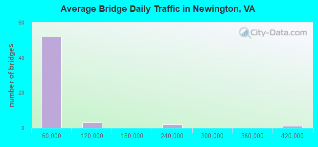
- 1,737,890Total average daily traffic
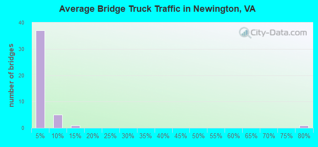
- 86,913Total average daily truck traffic
- National Bridge Inventory (NBI) Registered Bridges for Newington
- No street view available for this location
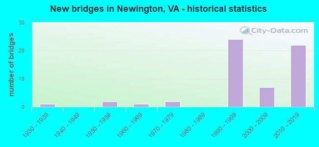
- New bridges - historical statistics
- 11930-1939
- 21950-1959
- 11960-1969
- 21970-1979
- 241990-1999
- 72000-2009
- 222010-2019
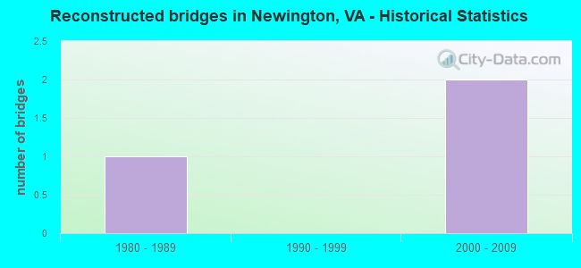
- Reconstructed bridges - Historical Statistics
- 11980-1989
- 01990-1999
- 22000-2009
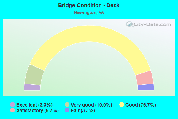
- Bridge Condition - Deck
- 3.3%Excellent
- 10.0%Very good
- 76.7%Good
- 6.7%Satisfactory
- 3.3%Fair
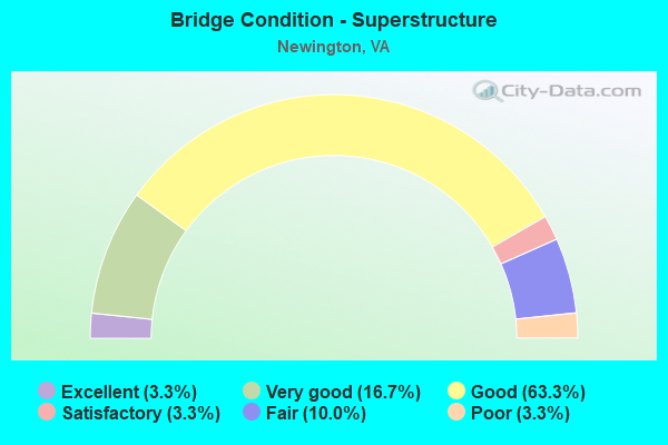
- Bridge Condition - Superstructure
- 3.3%Excellent
- 16.7%Very good
- 63.3%Good
- 3.3%Satisfactory
- 10.0%Fair
- 3.3%Poor
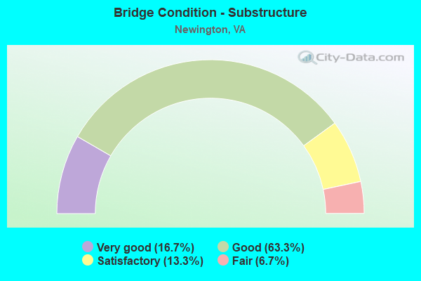
- Bridge Condition - Substructure
- 16.7%Very good
- 63.3%Good
- 13.3%Satisfactory
- 6.7%Fair

- Bridge Condition - Channel
- 19.0%Very good
- 38.1%Good
- 23.8%Satisfactory
- 19.0%Fair
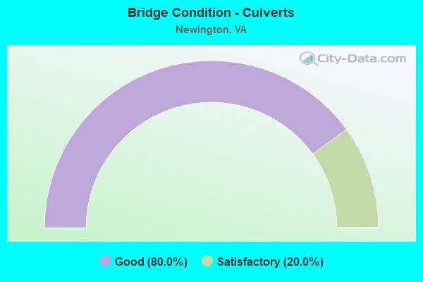
- Bridge Condition - Culverts
- 80.0%Good
- 20.0%Satisfactory
Find on map >> Show street view
Structure Number: 23722, Location: 00.16 3302 / 00.08 641 (Lat: 38.720256, Lng: -77.208097), Route carried "under" structure: Interstate 95, Year Built: 1993, Structure Length: 0. m, Features Intersected: R.F. & P. RR AND I-95, Facility Carried by Structure: POHICK ROAD
Minimum Vertical Clearance: 7.59m (24.90ft), Kilometerpoint: 0.000, Lanes on structure: 4, Lanes under structure: 4, Material/Design: Steel continuous, Design/Construction: Stringer/Multi-beam, Length of Maximum Span: 51.5m (169.0ft)
Find on map >> Show street view
Structure Number: 24886, Location: 01.00FR617/00.30TO611 (Lat: 38.727633, Lng: -77.186942), Route carried "under" structure: County highway 877, Year Built: 1997, Structure Length: 0. m, Average Daily Traffic: 800 (year 1994), Truck Traffic: 2%, Features Intersected: RTE.877-CINDER BED ROAD, Facility Carried by Structure: FAIRFAX CO.PKWY.SB
Minimum Vertical Clearance: 5.84m (19.16ft), Kilometerpoint: 0.000, Lanes on structure: 2, Lanes under structure: 3, Material/Design: Concrete, Design/Construction: Stringer/Multi-beam, Length of Maximum Span: 22.9m (75.1ft)
Find on map >> Show street view
Structure Number: 24887, Location: 01.11FR617/00.30TO611 (Lat: 38.727764, Lng: -77.186764), Route carried "under" structure: County highway 877, Year Built: 1997, Structure Length: 0. m, Average Daily Traffic: 800 (year 1994), Truck Traffic: 2%, Features Intersected: RTE. 877-CINDER BED ROAD, Facility Carried by Structure: FX.COUNTY PKWY NB
Minimum Vertical Clearance: 5.56m (18.24ft), Kilometerpoint: 0.000, Lanes on structure: 3, Lanes under structure: 3, Material/Design: Concrete, Design/Construction: Stringer/Multi-beam, Length of Maximum Span: 22.9m (75.1ft)
Find on map >> Show street view
Structure Number: 24935, Location: 01.3FR1/01.6TO613 (Lat: 38.724089, Lng: -77.183492), Route carried "under" structure: County highway 286, Year Built: 1997, Structure Length: 0. m, Average Daily Traffic: 8,000 (year 1996), Truck Traffic: 4%, Features Intersected: FAIRFAX CO.PKWY., Facility Carried by Structure: TELEGRAPH RD.
Minimum Vertical Clearance: 6.35m (20.83ft), Kilometerpoint: 0.000, Lanes on structure: 5, Lanes under structure: 2, Material/Design: Steel continuous, Design/Construction: Stringer/Multi-beam, Length of Maximum Span: 27.7m (90.9ft)
Find on map >> Show street view
Structure Number: 24935, Location: 01.3FR1/01.6TO613 (Lat: 38.724089, Lng: -77.183492), Route carried "under" structure: County highway 286, Year Built: 1997, Structure Length: 0. m, Average Daily Traffic: 8,000 (year 1996), Truck Traffic: 4%, Features Intersected: FAIRFAX CO.PKWY., Facility Carried by Structure: TELEGRAPH RD.
Minimum Vertical Clearance: 6.45m (21.16ft), Kilometerpoint: 0.000, Lanes on structure: 5, Lanes under structure: 2, Material/Design: Steel continuous, Design/Construction: Stringer/Multi-beam, Length of Maximum Span: 27.7m (90.9ft)
Find on map >> Show street view
Structure Number: 26619, Location: 00.00FR RAMP/00.00TO RAMP (Lat: 38.746472, Lng: -77.248806), Route carried "under" structure: Ramp County highway 286, Year Built: 2002, Structure Length: 0. m, Average Daily Traffic: 15,000 (year 2003), Features Intersected: FAIRFAX COUNTY PARKWAY, Facility Carried by Structure: POHICK ROAD CONN.
Minimum Vertical Clearance: 5.31m (17.42ft), Kilometerpoint: 0.000, Lanes on structure: 4, Lanes under structure: 2, Material/Design: Steel continuous, Design/Construction: Stringer/Multi-beam, Length of Maximum Span: 32.3m (106.0ft)
Find on map >> Show street view
Structure Number: 26619, Location: 00.00FR RAMP/00.00TO RAMP (Lat: 38.746472, Lng: -77.248806), Route carried "under" structure: Ramp County highway 286, Year Built: 2002, Structure Length: 0. m, Average Daily Traffic: 15,000 (year 2003), Features Intersected: FAIRFAX COUNTY PARKWAY, Facility Carried by Structure: POHICK ROAD CONN.
Minimum Vertical Clearance: 5.79m (19.00ft), Kilometerpoint: 0.000, Lanes on structure: 4, Lanes under structure: 2, Material/Design: Steel continuous, Design/Construction: Stringer/Multi-beam, Length of Maximum Span: 32.3m (106.0ft)
Find on map >> Show street view
Structure Number: 29333, Location: 00.30fr638 00.30 to End (Lat: 38.746986, Lng: -77.208878), Route carried "under" structure: Alternate County highway 286, Year Built: 2010, Structure Length: 0. m, Average Daily Traffic: 23,000 (year 2010), Truck Traffic: 2%, Features Intersected: Fairfax County Pkwy, Facility Carried by Structure: Barta Rd
Minimum Vertical Clearance: 5.72m (18.77ft), Kilometerpoint: 0.000, Lanes on structure: 8, Lanes under structure: 3, Material/Design: Prestressed concrete, Design/Construction: Stringer/Multi-beam, Length of Maximum Span: 31.6m (103.7ft)
Find on map >> Show street view
Structure Number: 29333, Location: 00.30fr638 00.30 to End (Lat: 38.746986, Lng: -77.208878), Route carried "under" structure: Alternate County highway 286, Year Built: 2010, Structure Length: 0. m, Average Daily Traffic: 22,500 (year 2010), Truck Traffic: 2%, Features Intersected: Fairfax County Pkwy, Facility Carried by Structure: Barta Rd
Minimum Vertical Clearance: 5.89m (19.32ft), Kilometerpoint: 0.000, Lanes on structure: 8, Lanes under structure: 4, Material/Design: Prestressed concrete, Design/Construction: Stringer/Multi-beam, Length of Maximum Span: 31.6m (103.7ft)
Find on map >> Show street view
Structure Number: 29334, Location: 00.30FR4600/01.15TO0638 (Lat: 38.745786, Lng: -77.196706), Route carried "under" structure: County highway , Year Built: 2010, Structure Length: 0. m, Average Daily Traffic: 1,000 (year 2010), Features Intersected: Boudinot Dr; Accotink Ck, Facility Carried by Structure: FFX Cnty Pkwy NBL
Minimum Vertical Clearance: 7.29m (23.92ft), Kilometerpoint: 0.000, Lanes on structure: 4, Lanes under structure: 2, Material/Design: Steel continuous, Design/Construction: Stringer/Multi-beam, Length of Maximum Span: 48.8m (160.1ft)
Find on map >> Show street view
Structure Number: 29335, Location: 00.30FR4600/01.15TO0638 (Lat: 38.745419, Lng: -77.197686), Route carried "under" structure: County highway , Year Built: 2010, Structure Length: 0. m, Average Daily Traffic: 1,000 (year 2010), Features Intersected: Boudinot Dr; Accotink Ck, Facility Carried by Structure: Ffx Cnty Pkwy;SBL
Minimum Vertical Clearance: 5.33m (17.49ft), Kilometerpoint: 0.000, Lanes on structure: 3, Lanes under structure: 2, Material/Design: Steel continuous, Design/Construction: Stringer/Multi-beam, Length of Maximum Span: 48.8m (160.1ft)
Find on map >> Show street view
Structure Number: 29336, Location: 00.32fr95 01.20to638 (Lat: 38.744333, Lng: -77.193067), Route carried "under" structure: Alternate County highway 4600, Year Built: 2010, Structure Length: 0. m, Average Daily Traffic: 24,500 (year 2010), Truck Traffic: 3%, Features Intersected: Fullerton Road, Facility Carried by Structure: Fairfax County Pkw
Minimum Vertical Clearance: 5.31m (17.42ft), Kilometerpoint: 0.000, Lanes on structure: 4, Lanes under structure: 4, Material/Design: Prestressed concrete, Design/Construction: Stringer/Multi-beam, Length of Maximum Span: 32.3m (106.0ft)
Find on map >> Show street view
Structure Number: 29339, Location: 0.50frBarta 0.50to7900 (Lat: 38.752281, Lng: -77.214969), Route carried "under" structure: Alternate County highway 286, Year Built: 2012, Structure Length: 0. m, Average Daily Traffic: 26,000 (year 2012), Truck Traffic: 3%, Features Intersected: Fairfax County Pkwy., Facility Carried by Structure: Rolling Road
Minimum Vertical Clearance: 5.56m (18.24ft), Kilometerpoint: 0.000, Lanes on structure: 3, Lanes under structure: 3, Material/Design: Concrete continuous, Design/Construction: Stringer/Multi-beam, Length of Maximum Span: 32.3m (106.0ft)
Find on map >> Show street view
Structure Number: 29339, Location: 0.50frBarta 0.50to7900 (Lat: 38.752281, Lng: -77.214969), Route carried "under" structure: Alternate County highway 286, Year Built: 2012, Structure Length: 0. m, Average Daily Traffic: 29,000 (year 2012), Truck Traffic: 4%, Features Intersected: Fairfax County Pkwy., Facility Carried by Structure: Rolling Road
Minimum Vertical Clearance: 5.51m (18.08ft), Kilometerpoint: 0.000, Lanes on structure: 3, Lanes under structure: 4, Material/Design: Concrete continuous, Design/Construction: Stringer/Multi-beam, Length of Maximum Span: 32.3m (106.0ft)
Find on map >> Show street view
Structure Number: 29964, Location: .10 FR HOV/.20TO790AlbanR (Lat: 38.736172, Lng: -77.193631), Route carried "under" structure: Interstate 95, Year Built: 2014, Structure Length: 0. m, Average Daily Traffic: 35,000 (year 2014), Truck Traffic: 4%, Features Intersected: ROUTE 95 SB
Minimum Vertical Clearance: 5.61m (18.41ft), Kilometerpoint: 0.000, Lanes on structure: 1, Lanes under structure: 4, Material/Design: Steel continuous, Design/Construction: Stringer/Multi-beam, Length of Maximum Span: 67.1m (220.1ft)
Find on map >> Show street view
Structure Number: 30118, Location: .00fr FBNA & .20to 95SB (Lat: 38.750339, Lng: -77.188328), Route carried "under" structure: Alternate Other road 95, Year Built: 2014, Structure Length: 0. m, Average Daily Traffic: 40,000 (year 2014), Truck Traffic: 1%, Features Intersected: SB-95;HOV;617;FLD LRK BR, Facility Carried by Structure: RAMP FROM FBNA
Minimum Vertical Clearance: 6.83m (22.41ft), Kilometerpoint: 0.000, Lanes on structure: 1, Lanes under structure: 3, Material/Design: Prestressed concrete, Design/Construction: Stringer/Multi-beam, Length of Maximum Span: 47.5m (155.8ft)
Find on map >> Show street view
Structure Number: 30118, Location: .00fr FBNA & .20to 95SB (Lat: 38.750339, Lng: -77.188328), Route carried "under" structure: Other road 617, Year Built: 2014, Structure Length: 0. m, Average Daily Traffic: 28,000 (year 2014), Truck Traffic: 3%, Features Intersected: SB-95;HOV;617;FLD LRK BR, Facility Carried by Structure: RAMP FROM FBNA
Minimum Vertical Clearance: 8.41m (27.59ft), Kilometerpoint: 0.000, Lanes on structure: 1, Lanes under structure: 6, Material/Design: Prestressed concrete, Design/Construction: Stringer/Multi-beam, Length of Maximum Span: 47.5m (155.8ft)
Find on map >> Show street view
Structure Number: 30118, Location: .00fr FBNA & .20to 95SB (Lat: 38.750339, Lng: -77.188328), Route carried "under" structure: Interstate 95, Year Built: 2014, Structure Length: 0. m, Average Daily Traffic: 68,000 (year 2014), Truck Traffic: 12%, Features Intersected: SB-95;HOV;617;FLD LRK BR, Facility Carried by Structure: RAMP FROM FBNA
Minimum Vertical Clearance: 7.54m (24.74ft), Kilometerpoint: 0.000, Lanes on structure: 1, Lanes under structure: 5, Material/Design: Prestressed concrete, Design/Construction: Stringer/Multi-beam, Length of Maximum Span: 47.5m (155.8ft)