Bridge Statistics for New Stanton, Pennsylvania (PA)
Condition, Traffic, Stress, Structural Evaluation, Project Costs
- National Bridge Inventory (NBI) Statistics
- 80Number of bridges
- 869ft / 265mTotal length
- $11,216,000Total costs
- 864,120Total average daily traffic
- 195,891Total average daily truck traffic
- National Bridge Inventory (NBI) Registered Bridges for New Stanton
- No street view available for this location
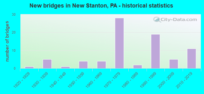
- New bridges - historical statistics
- 11920-1929
- 51930-1939
- 11940-1949
- 41950-1959
- 41960-1969
- 281970-1979
- 21980-1989
- 191990-1999
- 52000-2009
- 112010-2019

- Reconstructed bridges - Historical Statistics
- 31980-1989
- 21990-1999
- 12000-2009
- 12010-2019


- Bridge Condition - Deck
- 13.9%Very good
- 41.7%Good
- 25.0%Satisfactory
- 13.9%Fair
- 2.8%Poor
- 2.8%Serious

- Bridge Condition - Superstructure
- 18.4%Very good
- 26.3%Good
- 26.3%Satisfactory
- 21.1%Fair
- 7.9%Poor

- Bridge Condition - Substructure
- 21.1%Very good
- 31.6%Good
- 23.7%Satisfactory
- 21.1%Fair
- 2.6%Poor

- Bridge Condition - Channel
- 20.0%Very good
- 28.0%Good
- 24.0%Satisfactory
- 20.0%Fair
- 8.0%Poor

- Bridge Condition - Culverts
- 16.7%Very good
- 66.7%Satisfactory
- 16.7%Fair
Find on map >> Show street view
Structure Number: 5372, Location: EAST OF ROBESONIA (Lat: 40.350739, Lng: -76.115869), Route carried "on" structure: City street , Year Built: 1981, Status: Open, Structure Length: 1.55m (5.09ft), Average Daily Traffic: 400 (year 2010), Truck Traffic: 1%, Average Future Daily Traffic: 500 (year 2030), Design Load: HS 20, Features Intersected: FURNACE CREEK, Facility Carried by Structure: BIG SPRING ROAD
Minimum Vertical Clearance: 30+ m (98+ ft), Kilometerpoint: 0.000, Lanes on structure: 2, Owner: Town or Township Highway Agency, Approaching Roadway Width: 7.3m (24.0ft), Skew: 4 degrees, Material/Design: Prestressed concrete, Design/Construction: Box Beam or Girders - Multiple, Number Of Spans In Main Unit: 1, Length of Maximum Span: 14.9m (48.9ft), Curb or Sidewalk Widths: Left: 0.2m (0.7ft), Right: 0.2m (0.7ft), Curb-To-Curb Width: 10.0m (32.8ft), Out-to-Out Width: 11.1m (36.4ft)
Condition: Deck: Poor, Superstructure: Poor, Substructure: Satisfactory, Channel: Fair, Operating Rating: 65.3 metric tons, Method Used To Determine Operating Rating: Load Factor (LF), Inventory Rating: 24.5 metric tons, Method Used To Determine Inventory Rating: Load Factor (LF), Structural Evaluation: Meets minimum limits, Deck Geometry: Better than present minimum criteria, Waterway Adequacy: Better than present minimum criteria, Approach Roadway Alignment: Equal to present desirable criteria, Length Of Structure Improvement: 2.20m (7.22ft), Designated Inspection Frequency: Every 24 months, Inspection Date: May 2020, Deck Structure Type: Other, Wearing Surface/Protective System: Wearing Surface: Bituminous
Find on map >> Show street view
Structure Number: 36079, Location: HEMPFIELD TOWNSHIP (Lat: 40.212364, Lng: -79.590089), Route carried "on" structure: US 119, Year Built: 1975, Status: Open, Structure Length: 17.47m (57.32ft), Average Daily Traffic: 11,606 (year 2022), Truck Traffic: 14%, Average Future Daily Traffic: 8,720 (year 2032), Design Load: HS 20+Mod, Features Intersected: T`PIKE, T-547 & WILSON R
Minimum Vertical Clearance: 30+ m (98+ ft), Kilometerpoint: 11.914, Lanes on structure: 2, Lanes under structure: 6, Base Highway Network: Yes, Owner: State Highway Agency, Approaching Roadway Width: 12.2m (40.0ft), Skew: 12 degrees, Material/Design: Steel continuous, Design/Construction: Stringer/Multi-beam, Number Of Spans In Main Unit: 3, Number Of Approach Spans: 1, Length of Maximum Span: 50.9m (167.0ft), Curb or Sidewalk Widths: Left: 0.2m (0.7ft), Right: 0.2m (0.7ft), Curb-To-Curb Width: 12.9m (42.3ft), Out-to-Out Width: 14.0m (45.9ft)
Condition: Deck: Fair, Superstructure: Satisfactory, Substructure: Fair, Channel: Very good, Operating Rating: 83.5 metric tons, Method Used To Determine Operating Rating: Load Factor (LF), Inventory Rating: 49.9 metric tons, Method Used To Determine Inventory Rating: Load Factor (LF), Structural Evaluation: Somewhat better than minimum adequacy, Deck Geometry: Superior to present desirable criteria, Underclear: Equal to present minimum criteria, Waterway Adequacy: Superior to present desirable criteria, Approach Roadway Alignment: Equal to present desirable criteria, Length Of Structure Improvement: 18.30m (60.04ft), Designated Inspection Frequency: Every 24 months, Inspection Date: July 2021, Deck Structure Type: Concrete Cast-file-Place, Wearing Surface/Protective System: Wearing Surface: Bituminous, Membrane: Preformed Fabric, Deck Protection: Galvanized Reinforcing
Find on map >> Show street view
Structure Number: 36081, Location: HEMPFIELD TOWNSHIP (Lat: 40.212178, Lng: -79.590328), Route carried "on" structure: US 119, Year Built: 1975, Status: Open, Structure Length: 17.47m (57.32ft), Average Daily Traffic: 11,266 (year 2022), Truck Traffic: 13%, Average Future Daily Traffic: 9,495 (year 2032), Design Load: HS 20+Mod, Features Intersected: T`PIKE, T-547 & WILSON R
Minimum Vertical Clearance: 30+ m (98+ ft), Kilometerpoint: 11.927, Lanes on structure: 2, Lanes under structure: 10, Base Highway Network: Yes, Owner: State Highway Agency, Approaching Roadway Width: 12.2m (40.0ft), Skew: 12 degrees, Material/Design: Steel continuous, Design/Construction: Stringer/Multi-beam, Number Of Spans In Main Unit: 3, Number Of Approach Spans: 1, Length of Maximum Span: 50.9m (167.0ft), Curb or Sidewalk Widths: Left: 0.2m (0.7ft), Right: 0.2m (0.7ft), Curb-To-Curb Width: 12.9m (42.3ft), Out-to-Out Width: 14.0m (45.9ft)
Condition: Deck: Satisfactory, Superstructure: Satisfactory, Substructure: Satisfactory, Channel: Very good, Operating Rating: 83.5 metric tons, Method Used To Determine Operating Rating: Load Factor (LF), Inventory Rating: 49.9 metric tons, Method Used To Determine Inventory Rating: Load Factor (LF), Structural Evaluation: Equal to present minimum criteria, Deck Geometry: Superior to present desirable criteria, Underclear: Equal to present minimum criteria, Waterway Adequacy: Superior to present desirable criteria, Approach Roadway Alignment: Equal to present desirable criteria, Length Of Structure Improvement: 18.30m (60.04ft), Designated Inspection Frequency: Every 24 months, Inspection Date: July 2021, Deck Structure Type: Concrete Cast-file-Place, Wearing Surface/Protective System: Wearing Surface: Bituminous, Membrane: Preformed Fabric, Deck Protection: Galvanized Reinforcing
Find on map >> Show street view
Structure Number: 36082, Location: NEW STANTON BOROUGH (Lat: 40.220447, Lng: -79.591878), Route carried "on" structure: US 119, Year Built: 1977, Status: Open, Structure Length: 6.28m (20.60ft), Average Daily Traffic: 11,606 (year 2022), Truck Traffic: 14%, Average Future Daily Traffic: 8,720 (year 2032), Design Load: HS 20+Mod, Features Intersected: TWP. THERMAL ROAD
Minimum Vertical Clearance: 30+ m (98+ ft), Kilometerpoint: 12.870, Lanes on structure: 3, Lanes under structure: 2, Base Highway Network: Yes, Owner: State Highway Agency, Approaching Roadway Width: 10.4m (34.1ft), Skew: 14 degrees, Material/Design: Prestressed concrete, Design/Construction: Stringer/Multi-beam, Number Of Spans In Main Unit: 3, Length of Maximum Span: 24.4m (80.1ft), Curb or Sidewalk Widths: Left: 0.2m (0.7ft), Right: 0.2m (0.7ft), Curb-To-Curb Width: 17.4m (57.1ft), Out-to-Out Width: 19.2m (63.0ft)
Condition: Deck: Satisfactory, Superstructure: Satisfactory, Substructure: Satisfactory, Operating Rating: 74.4 metric tons, Method Used To Determine Operating Rating: Load Factor (LF), Inventory Rating: 38.1 metric tons, Method Used To Determine Inventory Rating: Load Factor (LF), Structural Evaluation: Equal to present minimum criteria, Deck Geometry: Better than present minimum criteria, Underclear: Equal to present minimum criteria, Approach Roadway Alignment: Equal to present desirable criteria, Length Of Structure Improvement: 7.20m (23.62ft), Designated Inspection Frequency: Every 24 months, Inspection Date: May 2021, Deck Structure Type: Concrete Cast-file-Place, Wearing Surface/Protective System: Wearing Surface: Monolithic Concrete, Deck Protection: Epoxy Coated Reinforcing
Find on map >> Show street view
Structure Number: 36083, Location: NEW STANTON BOROUGH (Lat: 40.223764, Lng: -79.592408), Route carried "on" structure: US 119, Year Built: 1977, Status: Open, Structure Length: 11.73m (38.48ft), Average Daily Traffic: 11,606 (year 2022), Truck Traffic: 14%, Average Future Daily Traffic: 8,720 (year 2032), Design Load: HS 20, Features Intersected: SW PA R/R, SEWICKLEY CK
Minimum Vertical Clearance: 30+ m (98+ ft), Kilometerpoint: 12.870, Lanes on structure: 2, Base Highway Network: Yes, Owner: State Highway Agency, Approaching Roadway Width: 14.0m (45.9ft), Skew: 2 degrees, Material/Design: Prestressed concrete, Design/Construction: Stringer/Multi-beam, Number Of Spans In Main Unit: 5, Length of Maximum Span: 25.0m (82.0ft), Curb or Sidewalk Widths: Left: 0.2m (0.7ft), Right: 0.2m (0.7ft), Curb-To-Curb Width: 12.8m (42.0ft), Out-to-Out Width: 13.9m (45.6ft)
Condition: Deck: Satisfactory, Superstructure: Satisfactory, Substructure: Satisfactory, Channel: Good, Operating Rating: 68.0 metric tons, Method Used To Determine Operating Rating: Load Factor (LF), Inventory Rating: 40.8 metric tons, Method Used To Determine Inventory Rating: Load Factor (LF), Structural Evaluation: Equal to present minimum criteria, Deck Geometry: Equal to present desirable criteria, Underclear: High priority of corrective action, Waterway Adequacy: Superior to present desirable criteria, Approach Roadway Alignment: Equal to present desirable criteria, Length Of Structure Improvement: 12.80m (41.99ft), Designated Inspection Frequency: Every 24 months, Inspection Date: May 2021, Deck Structure Type: Concrete Cast-file-Place, Wearing Surface/Protective System: Wearing Surface: Monolithic Concrete, Deck Protection: Epoxy Coated Reinforcing
Find on map >> Show street view
Structure Number: 36084, Location: NEW STANTON BOROUGH (Lat: 40.219858, Lng: -79.592178), Route carried "on" structure: US 119, Year Built: 1977, Status: Open, Structure Length: 6.74m (22.11ft), Average Daily Traffic: 11,266 (year 2022), Truck Traffic: 13%, Average Future Daily Traffic: 9,495 (year 2032), Design Load: HS 20+Mod, Features Intersected: TWP. THERMAL ROAD
Minimum Vertical Clearance: 30+ m (98+ ft), Kilometerpoint: 12.852, Lanes on structure: 3, Lanes under structure: 2, Base Highway Network: Yes, Owner: State Highway Agency, Approaching Roadway Width: 19.2m (63.0ft), Skew: 14 degrees, Material/Design: Prestressed concrete, Design/Construction: Stringer/Multi-beam, Number Of Spans In Main Unit: 3, Length of Maximum Span: 26.2m (86.0ft), Curb or Sidewalk Widths: Left: 0.2m (0.7ft), Right: 0.2m (0.7ft), Curb-To-Curb Width: 19.2m (63.0ft), Out-to-Out Width: 19.5m (64.0ft)
Condition: Deck: Fair, Superstructure: Fair, Substructure: Fair, Operating Rating: 76.2 metric tons, Method Used To Determine Operating Rating: Load Factor (LF), Inventory Rating: 45.4 metric tons, Method Used To Determine Inventory Rating: Load Factor (LF), Structural Evaluation: Somewhat better than minimum adequacy, Deck Geometry: Superior to present desirable criteria, Underclear: Superior to present desirable criteria, Approach Roadway Alignment: Equal to present desirable criteria, Length Of Structure Improvement: 7.70m (25.26ft), Designated Inspection Frequency: Every 24 months, Inspection Date: May 2021, Deck Structure Type: Concrete Cast-file-Place, Wearing Surface/Protective System: Wearing Surface: Monolithic Concrete, Deck Protection: Epoxy Coated Reinforcing
Find on map >> Show street view
Structure Number: 36085, Location: NEW STANTON BOROUGH (Lat: 40.223233, Lng: -79.592581), Route carried "on" structure: US 119, Year Built: 1977, Status: Open, Structure Length: 12.07m (39.60ft), Average Daily Traffic: 11,266 (year 2022), Truck Traffic: 13%, Average Future Daily Traffic: 9,495 (year 2032), Design Load: HS 20, Features Intersected: SW PA R/R, SEWICKLEY CK
Minimum Vertical Clearance: 30+ m (98+ ft), Kilometerpoint: 12.852, Lanes on structure: 2, Base Highway Network: Yes, Owner: State Highway Agency, Approaching Roadway Width: 12.8m (42.0ft), Skew: 12 degrees, Material/Design: Prestressed concrete, Design/Construction: Stringer/Multi-beam, Number Of Spans In Main Unit: 5, Length of Maximum Span: 25.0m (82.0ft), Curb or Sidewalk Widths: Left: 0.2m (0.7ft), Right: 0.2m (0.7ft), Curb-To-Curb Width: 12.8m (42.0ft), Out-to-Out Width: 13.9m (45.6ft)
Condition: Deck: Satisfactory, Superstructure: Satisfactory, Substructure: Fair, Channel: Very good, Operating Rating: 68.0 metric tons, Method Used To Determine Operating Rating: Load Factor (LF), Inventory Rating: 40.8 metric tons, Method Used To Determine Inventory Rating: Load Factor (LF), Structural Evaluation: Somewhat better than minimum adequacy, Deck Geometry: Equal to present desirable criteria, Underclear: High priority of corrective action, Waterway Adequacy: Superior to present desirable criteria, Approach Roadway Alignment: Equal to present desirable criteria, Length Of Structure Improvement: 12.80m (41.99ft), Designated Inspection Frequency: Every 24 months, Inspection Date: May 2021, Deck Structure Type: Concrete Cast-file-Place, Wearing Surface/Protective System: Wearing Surface: Monolithic Concrete, Deck Protection: Epoxy Coated Reinforcing
Find on map >> Show street view
Structure Number: 36086, Location: NEW STANTON BOROUGH (Lat: 40.225447, Lng: -79.593789), Route carried "on" structure: US 119, Year Built: 1977, Year Reconstructed: 1992, Status: Open, Structure Length: 6.83m (22.41ft), Average Daily Traffic: 11,266 (year 2022), Truck Traffic: 13%, Average Future Daily Traffic: 9,495 (year 2032), Design Load: HS 20+Mod, Features Intersected: SR 3091, SR 0119
Minimum Vertical Clearance: 30+ m (98+ ft), Kilometerpoint: 12.852, Lanes on structure: 3, Lanes under structure: 24, Base Highway Network: Yes, Owner: State Highway Agency, Approaching Roadway Width: 12.2m (40.0ft), Skew: 10 degrees, Material/Design: Steel, Design/Construction: Stringer/Multi-beam, Number Of Spans In Main Unit: 1, Number Of Approach Spans: 2, Length of Maximum Span: 36.9m (121.1ft), Curb or Sidewalk Widths: Left: 0.2m (0.7ft), Right: 0.2m (0.7ft), Curb-To-Curb Width: 15.8m (51.8ft), Out-to-Out Width: 16.9m (55.4ft)
Condition: Deck: Satisfactory, Superstructure: Fair, Substructure: Satisfactory, Operating Rating: 98.0 metric tons, Method Used To Determine Operating Rating: Load Factor (LF), Inventory Rating: 59.0 metric tons, Method Used To Determine Inventory Rating: Load Factor (LF), Structural Evaluation: Somewhat better than minimum adequacy, Deck Geometry: Somewhat better than minimum adequacy, Underclear: Meets minimum limits, Approach Roadway Alignment: Equal to present desirable criteria, Length Of Structure Improvement: 6.80m (22.31ft), Designated Inspection Frequency: Every 24 months, Inspection Date: May 2021, Bridge Improvement Cost: $50,000, Roadway Improvement Cost: $200,000, Total Project Cost: $674,000, Deck Structure Type: Other, Wearing Surface/Protective System: Wearing Surface: Latex Concrete, Deck Protection: Epoxy Coated Reinforcing
Find on map >> Show street view
Structure Number: 36477, Location: HEMPFIELD TOWNSHIP (Lat: 40.226689, Lng: -79.588292), Route carried "on" structure: State highway , Year Built: 1961, Status: Open, Structure Length: 2.96m (9.71ft), Average Daily Traffic: 2,319 (year 2021), Truck Traffic: 6%, Average Future Daily Traffic: 1,992 (year 2032), Design Load: HS 20, Features Intersected: SEWICKLEY CREEK, Facility Carried by Structure: SR 2010
Minimum Vertical Clearance: 30+ m (98+ ft), Kilometerpoint: 0.000, Lanes on structure: 2, Owner: State Highway Agency, Approaching Roadway Width: 7.6m (24.9ft), Material/Design: Prestressed concrete, Design/Construction: Box Beam or Girders - Multiple, Number Of Spans In Main Unit: 2, Length of Maximum Span: 14.3m (46.9ft), Curb or Sidewalk Widths: Left: 0.4m (1.3ft), Right: 0.4m (1.3ft), Curb-To-Curb Width: 11.6m (38.1ft), Out-to-Out Width: 13.3m (43.6ft)
Condition: Deck: Satisfactory, Superstructure: Satisfactory, Substructure: Fair, Channel: Poor, Operating Rating: 61.7 metric tons, Method Used To Determine Operating Rating: Load Factor (LF), Inventory Rating: 35.4 metric tons, Method Used To Determine Inventory Rating: Load Factor (LF), Structural Evaluation: Somewhat better than minimum adequacy, Deck Geometry: Somewhat better than minimum adequacy, Waterway Adequacy: Superior to present desirable criteria, Approach Roadway Alignment: Equal to present desirable criteria, Length Of Structure Improvement: 3.70m (12.14ft), Designated Inspection Frequency: Every 24 months, Inspection Date: December 2019, Deck Structure Type: Concrete Cast-file-Place, Wearing Surface/Protective System: Wearing Surface: Monolithic Concrete
Find on map >> Show street view
Structure Number: 36657, Location: NEW STANTON BOROUGH (Lat: 40.223778, Lng: -79.596369), Route carried "on" structure: State highway , Year Built: 1951, Year Reconstructed: 1992, Status: Open, Structure Length: 0.64m (2.10ft), Average Daily Traffic: 25,766 (year 2021), Truck Traffic: 18%, Average Future Daily Traffic: 38,546 (year 2043), Design Load: HS 20, Features Intersected: BRANCH OF SEWICKLEY CK., Facility Carried by Structure: SR 3091
Minimum Vertical Clearance: 30+ m (98+ ft), Kilometerpoint: 0.230, Lanes on structure: 6, Base Highway Network: Yes, Owner: State Highway Agency, Approaching Roadway Width: 21.9m (71.9ft), Skew: 31 degrees, Material/Design: Concrete, Design/Construction: Culvert, Number Of Spans In Main Unit: 1, Length of Maximum Span: 6.4m (21.0ft)
Condition: Channel: Fair, Culverts: Satisfactory, Operating Rating: 49.0 metric tons, Method Used To Determine Operating Rating: Field evaluation and documented engineering judgment, Inventory Rating: 32.7 metric tons, Method Used To Determine Inventory Rating: Field evaluation and documented engineering judgment, Structural Evaluation: Equal to present minimum criteria, Waterway Adequacy: Superior to present desirable criteria, Approach Roadway Alignment: Equal to present desirable criteria, Length Of Structure Improvement: 0.60m (1.97ft), Designated Inspection Frequency: Every 24 months, Inspection Date: May 2021, Bridge Improvement Cost: $26,000, Roadway Improvement Cost: $150,000, Total Project Cost: $354,000
Find on map >> Show street view
Structure Number: 36663, Location: NEW STANTON BOROUGH (Lat: 40.210553, Lng: -79.605797), Route carried "on" structure: State highway , Year Built: 1957, Status: Open, Structure Length: 1.22m (4.00ft), Average Daily Traffic: 7,095 (year 2022), Truck Traffic: 5%, Average Future Daily Traffic: 9,534 (year 2032), Design Load: HS 20, Features Intersected: WILSON RUN, Facility Carried by Structure: SR 3093
Minimum Vertical Clearance: 30+ m (98+ ft), Kilometerpoint: 8.513, Lanes on structure: 2, Owner: State Highway Agency, Approaching Roadway Width: 11.6m (38.1ft), Skew: 1 degrees, Material/Design: Concrete, Design/Construction: Tee Beam, Number Of Spans In Main Unit: 1, Length of Maximum Span: 11.6m (38.1ft), Curb-To-Curb Width: 11.6m (38.1ft), Out-to-Out Width: 13.1m (43.0ft)
Condition: Deck: Good, Superstructure: Fair, Substructure: Poor, Channel: Poor, Operating Rating: 52.6 metric tons, Method Used To Determine Operating Rating: Load Factor (LF), Inventory Rating: 33.6 metric tons, Method Used To Determine Inventory Rating: Load Factor (LF), Structural Evaluation: Meets minimum limits, Deck Geometry: Somewhat better than minimum adequacy, Waterway Adequacy: Superior to present desirable criteria, Approach Roadway Alignment: Equal to present desirable criteria, Length Of Structure Improvement: 1.90m (6.23ft), Designated Inspection Frequency: Every 24 months, Inspection Date: Febuary 2020, Bridge Improvement Cost: $6,000, Roadway Improvement Cost: $17,000, Total Project Cost: $79,000, Deck Structure Type: Concrete Cast-file-Place, Wearing Surface/Protective System: Wearing Surface: Bituminous
Find on map >> Show street view
Structure Number: 36664, Location: NEW STANTON BOROUGH (Lat: 40.215325, Lng: -79.606539), Route carried "on" structure: State highway , Year Built: 1950, Year Reconstructed: 2017, Status: Open, Structure Length: 11.67m (38.29ft), Average Daily Traffic: 7,095 (year 2022), Truck Traffic: 5%, Average Future Daily Traffic: 9,534 (year 2032), Design Load: HL 93, Features Intersected: SW PA R/R, RD, SEWICKLEY, Facility Carried by Structure: SR 3093
Minimum Vertical Clearance: 30+ m (98+ ft), Kilometerpoint: 8.513, Lanes on structure: 2, Lanes under structure: 1, Owner: State Highway Agency, Approaching Roadway Width: 8.5m (27.9ft), Material/Design: Steel continuous, Design/Construction: Stringer/Multi-beam, Number Of Spans In Main Unit: 3, Number Of Approach Spans: 2, Length of Maximum Span: 27.4m (89.9ft), Curb or Sidewalk Widths: Left: 1.7m (5.6ft), Right: 0.1m (0.3ft), Curb-To-Curb Width: 10.4m (34.1ft), Out-to-Out Width: 12.9m (42.3ft)
Condition: Deck: Very good, Superstructure: Very good, Substructure: Very good, Channel: Very good, Operating Rating: 44.1 metric tons, Method Used To Determine Operating Rating: Assigned ratings based on Load and Resistance Factor Design (LRFD) reported by rating factor (RF) using HL93 loadings, Inventory Rating: 33.7 metric tons, Method Used To Determine Inventory Rating: Assigned ratings based on Load and Resistance Factor Design (LRFD) reported by rating factor (RF) using HL93 loadings, Structural Evaluation: Equal to present desirable criteria, Deck Geometry: Meets minimum limits, Underclear: High priority of corrective action, Waterway Adequacy: Superior to present desirable criteria, Approach Roadway Alignment: Equal to present desirable criteria, Length Of Structure Improvement: 12.60m (41.34ft), Designated Inspection Frequency: Every 24 months, Inspection Date: Febuary 2020, Bridge Improvement Cost: $130,000, Roadway Improvement Cost: $383,000, Total Project Cost: $1,755,000, Deck Structure Type: Concrete Cast-file-Place, Wearing Surface/Protective System: Wearing Surface: Monolithic Concrete, Deck Protection: Epoxy Coated Reinforcing
Find on map >> Show street view
Structure Number: 36668, Location: HEMPFIELD TOWNSHIP (Lat: 40.218333, Lng: -79.578333), Route carried "on" structure: State highway , Year Built: 1977, Status: Open, Structure Length: 9.78m (32.09ft), Average Daily Traffic: 3,789 (year 2020), Truck Traffic: 17%, Average Future Daily Traffic: 5,977 (year 2032), Design Load: HS 20, Features Intersected: SR 0119, Facility Carried by Structure: SR 3095
Minimum Vertical Clearance: 30+ m (98+ ft), Kilometerpoint: 0.568, Lanes on structure: 2, Lanes under structure: 4, Owner: State Highway Agency, Approaching Roadway Width: 21.9m (71.9ft), Skew: 33 degrees, Material/Design: Steel continuous, Design/Construction: Stringer/Multi-beam, Number Of Spans In Main Unit: 2, Number Of Approach Spans: 2, Length of Maximum Span: 32.0m (105.0ft), Curb or Sidewalk Widths: Left: 0.2m (0.7ft), Right: 0.2m (0.7ft), Curb-To-Curb Width: 15.8m (51.8ft), Out-to-Out Width: 23.0m (75.5ft)
Condition: Deck: Satisfactory, Superstructure: Fair, Substructure: Good, Operating Rating: 70.8 metric tons, Method Used To Determine Operating Rating: Load Factor (LF), Inventory Rating: 42.6 metric tons, Method Used To Determine Inventory Rating: Load Factor (LF), Structural Evaluation: Somewhat better than minimum adequacy, Deck Geometry: Superior to present desirable criteria, Underclear: Superior to present desirable criteria, Approach Roadway Alignment: Equal to present desirable criteria, Length Of Structure Improvement: 10.80m (35.43ft), Designated Inspection Frequency: Every 24 months, Inspection Date: Febuary 2020, Bridge Improvement Cost: $100,000, Roadway Improvement Cost: $295,000, Total Project Cost: $1,352,000, Deck Structure Type: Concrete Cast-file-Place, Wearing Surface/Protective System: Wearing Surface: Monolithic Concrete, Deck Protection: Galvanized Reinforcing
Find on map >> Show street view
Structure Number: 36782, Location: NEW STANTON BOROUGH (Lat: 40.221667, Lng: -79.595000), Route carried "on" structure: US 66, Year Built: 1977, Year Reconstructed: 1991, Status: Open, Structure Length: 6.74m (22.11ft), Average Daily Traffic: 8,392 (year 1995), Truck Traffic: 7%, Average Future Daily Traffic: 12,741 (year 2030), Design Load: HS 20+Mod, Features Intersected: SR 0119
Minimum Vertical Clearance: 30+ m (98+ ft), Kilometerpoint: 0.000, Lanes on structure: 3, Lanes under structure: 12, Base Highway Network: Yes, Toll: On toll road, Owner: State Toll Authority, Approaching Roadway Width: 15.8m (51.8ft), Skew: 10 degrees, Material/Design: Steel, Design/Construction: Stringer/Multi-beam, Number Of Spans In Main Unit: 1, Number Of Approach Spans: 2, Length of Maximum Span: 36.9m (121.1ft), Curb or Sidewalk Widths: Left: 0.2m (0.7ft), Right: 0.2m (0.7ft), Curb-To-Curb Width: 15.8m (51.8ft), Out-to-Out Width: 16.9m (55.4ft)
Condition: Deck: Good, Superstructure: Satisfactory, Substructure: Good, Operating Rating: 69.9 metric tons, Method Used To Determine Operating Rating: Load Factor (LF), Inventory Rating: 41.7 metric tons, Method Used To Determine Inventory Rating: Load Factor (LF), Structural Evaluation: Equal to present minimum criteria, Deck Geometry: Somewhat better than minimum adequacy, Underclear: Meets minimum limits, Approach Roadway Alignment: Equal to present desirable criteria, Length Of Structure Improvement: 6.90m (22.64ft), Designated Inspection Frequency: Every 48 months, Inspection Date: July 2018, Bridge Improvement Cost: $48,000, Roadway Improvement Cost: $200,000, Total Project Cost: $653,000, Deck Structure Type: Concrete Cast-file-Place, Wearing Surface/Protective System: Wearing Surface: Monolithic Concrete, Deck Protection: Epoxy Coated Reinforcing
Find on map >> Show street view
Structure Number: 36783, Location: NEW STANTON BOROUGH (Lat: 40.233061, Lng: -79.601408), Route carried "on" structure: City street , Year Built: 1991, Status: Open, Structure Length: 7.83m (25.69ft), Average Daily Traffic: 2,000 (year 2008), Truck Traffic: 8%, Average Future Daily Traffic: 2,601 (year 2030), Design Load: HS 25 or greater, Features Intersected: PA TPK (PA-66), Facility Carried by Structure: T-682
Minimum Vertical Clearance: 30+ m (98+ ft), Kilometerpoint: 0.000, Lanes on structure: 2, Lanes under structure: 6, Owner: State Toll Authority, Approaching Roadway Width: 18.3m (60.0ft), Skew: 20 degrees, Material/Design: Steel continuous, Design/Construction: Stringer/Multi-beam, Number Of Spans In Main Unit: 2, Length of Maximum Span: 40.8m (133.9ft), Curb or Sidewalk Widths: Left: 0.2m (0.7ft), Right: 0.2m (0.7ft), Curb-To-Curb Width: 18.3m (60.0ft), Out-to-Out Width: 19.4m (63.6ft)
Condition: Deck: Good, Superstructure: Good, Substructure: Good, Operating Rating: 78.0 metric tons, Method Used To Determine Operating Rating: Load Factor (LF), Inventory Rating: 46.3 metric tons, Method Used To Determine Inventory Rating: Load Factor (LF), Structural Evaluation: Better than present minimum criteria, Deck Geometry: Superior to present desirable criteria, Underclear: Better than present minimum criteria, Approach Roadway Alignment: Equal to present desirable criteria, Designated Inspection Frequency: Every 48 months, Inspection Date: September 2019, Deck Structure Type: Concrete Cast-file-Place, Wearing Surface/Protective System: Wearing Surface: Latex Concrete, Deck Protection: Epoxy Coated Reinforcing
Find on map >> Show street view
Structure Number: 36784, Location: HEMPFIELD TWP (Lat: 40.233503, Lng: -79.601783), Route carried "on" structure: Ramp Other road 66, Year Built: 1991, Status: Open, Structure Length: 0.88m (2.89ft), Average Daily Traffic: 500 (year 2008), Truck Traffic: 10%, Average Future Daily Traffic: 651 (year 2030), Features Intersected: GB-105
Minimum Vertical Clearance: 30+ m (98+ ft), Kilometerpoint: 0.000, Lanes on structure: 1, Base Highway Network: Yes, Toll: On toll road, Owner: State Toll Authority, Approaching Roadway Width: 8.5m (27.9ft), Skew: 1 degrees, Material/Design: Concrete, Design/Construction: Culvert, Number Of Spans In Main Unit: 2, Length of Maximum Span: 3.7m (12.1ft)
Condition: Channel: Good, Culverts: Satisfactory, Operating Rating: 89.8 metric tons, Method Used To Determine Operating Rating: Load Factor (LF), Inventory Rating: 32.7 metric tons, Method Used To Determine Inventory Rating: Load Factor (LF), Structural Evaluation: Equal to present minimum criteria, Waterway Adequacy: Superior to present desirable criteria, Approach Roadway Alignment: Equal to present desirable criteria, Designated Inspection Frequency: Every 48 months, Inspection Date: September 2019
Find on map >> Show street view
Structure Number: 36785, Location: HEMPFIELD TWP (Lat: 40.235639, Lng: -79.603422), Route carried "on" structure: Other road 66, Year Built: 1991, Status: Open, Structure Length: 0.98m (3.22ft), Average Daily Traffic: 15,194 (year 2008), Truck Traffic: 15%, Average Future Daily Traffic: 19,754 (year 2030), Features Intersected: Br. Sewickley Creek
Minimum Vertical Clearance: 30+ m (98+ ft), Kilometerpoint: 0.000, Lanes on structure: 5, Base Highway Network: Yes, Toll: On toll road, Owner: State Toll Authority, Approaching Roadway Width: 52.4m (171.9ft), Skew: 24 degrees, Material/Design: Concrete, Design/Construction: Culvert, Number Of Spans In Main Unit: 2, Length of Maximum Span: 3.7m (12.1ft)
Condition: Channel: Fair, Culverts: Satisfactory, Operating Rating: 89.8 metric tons, Method Used To Determine Operating Rating: Load Factor (LF), Inventory Rating: 32.7 metric tons, Method Used To Determine Inventory Rating: Load Factor (LF), Structural Evaluation: Equal to present minimum criteria, Waterway Adequacy: Superior to present desirable criteria, Approach Roadway Alignment: Equal to present desirable criteria, Designated Inspection Frequency: Every 48 months, Inspection Date: September 2019
Find on map >> Show street view
Structure Number: 36786, Location: HEMPFIELD TWP (Lat: 40.256803, Lng: -79.612903), Route carried "on" structure: State highway 66, Year Built: 1991, Status: Open, Structure Length: 7.59m (24.90ft), Average Daily Traffic: 10,429 (year 1998), Truck Traffic: 15%, Average Future Daily Traffic: 15,277 (year 2030), Design Load: HS 25 or greater, Features Intersected: SR 2012
Minimum Vertical Clearance: 30+ m (98+ ft), Kilometerpoint: 0.000, Lanes on structure: 2, Lanes under structure: 2, Base Highway Network: Yes, Toll: On toll road, Owner: State Toll Authority, Approaching Roadway Width: 12.8m (42.0ft), Skew: 15 degrees, Material/Design: Steel continuous, Design/Construction: Stringer/Multi-beam, Number Of Spans In Main Unit: 3, Length of Maximum Span: 30.5m (100.1ft), Curb or Sidewalk Widths: Left: 0.2m (0.7ft), Right: 0.2m (0.7ft), Curb-To-Curb Width: 12.8m (42.0ft), Out-to-Out Width: 13.9m (45.6ft)
Condition: Deck: Good, Superstructure: Good, Substructure: Good, Operating Rating: 63.5 metric tons, Method Used To Determine Operating Rating: Load Factor (LF), Inventory Rating: 38.1 metric tons, Method Used To Determine Inventory Rating: Load Factor (LF), Structural Evaluation: Better than present minimum criteria, Deck Geometry: Equal to present desirable criteria, Underclear: Superior to present desirable criteria, Approach Roadway Alignment: Equal to present desirable criteria, Designated Inspection Frequency: Every 48 months, Inspection Date: November 2019, Deck Structure Type: Concrete Cast-file-Place, Wearing Surface/Protective System: Wearing Surface: Latex Concrete, Deck Protection: Epoxy Coated Reinforcing
Find on map >> Show street view
Structure Number: 36787, Location: HEMPFIELD TWP (Lat: 40.255000, Lng: -79.610000), Route carried "on" structure: State highway 66, Year Built: 1991, Status: Open, Structure Length: 7.59m (24.90ft), Average Daily Traffic: 10,429 (year 1998), Truck Traffic: 15%, Average Future Daily Traffic: 15,277 (year 2030), Design Load: HS 25 or greater, Features Intersected: SR 2012
Minimum Vertical Clearance: 30+ m (98+ ft), Kilometerpoint: 0.000, Lanes on structure: 2, Lanes under structure: 2, Base Highway Network: Yes, Toll: On toll road, Owner: State Toll Authority, Approaching Roadway Width: 12.8m (42.0ft), Skew: 15 degrees, Material/Design: Steel continuous, Design/Construction: Stringer/Multi-beam, Number Of Spans In Main Unit: 3, Length of Maximum Span: 30.5m (100.1ft), Curb or Sidewalk Widths: Left: 0.2m (0.7ft), Right: 0.2m (0.7ft), Curb-To-Curb Width: 12.8m (42.0ft), Out-to-Out Width: 13.9m (45.6ft)
Condition: Deck: Good, Superstructure: Good, Substructure: Good, Operating Rating: 63.5 metric tons, Method Used To Determine Operating Rating: Load Factor (LF), Inventory Rating: 38.1 metric tons, Method Used To Determine Inventory Rating: Load Factor (LF), Structural Evaluation: Better than present minimum criteria, Deck Geometry: Equal to present desirable criteria, Underclear: Superior to present desirable criteria, Approach Roadway Alignment: Equal to present desirable criteria, Designated Inspection Frequency: Every 48 months, Inspection Date: November 2019, Deck Structure Type: Concrete Cast-file-Place, Wearing Surface/Protective System: Wearing Surface: Latex Concrete, Deck Protection: Epoxy Coated Reinforcing
Find on map >> Show street view
Structure Number: 36788, Location: HEMPFIELD TWP (Lat: 40.265536, Lng: -79.614708), Route carried "on" structure: State highway , Year Built: 1991, Status: Open, Structure Length: 9.30m (30.51ft), Average Daily Traffic: 1,997 (year 2022), Truck Traffic: 2%, Average Future Daily Traffic: 2,773 (year 2032), Design Load: HS 25 or greater, Features Intersected: Tpk 66 MP G003.05 GB-110, Facility Carried by Structure: SR 3016
Minimum Vertical Clearance: 30+ m (98+ ft), Kilometerpoint: 17.603, Lanes on structure: 2, Lanes under structure: 4, Owner: State Highway Agency, Approaching Roadway Width: 13.4m (44.0ft), Skew: 3 degrees, Material/Design: Steel continuous, Design/Construction: Stringer/Multi-beam, Number Of Spans In Main Unit: 2, Length of Maximum Span: 45.7m (149.9ft), Curb or Sidewalk Widths: Left: 0.2m (0.7ft), Right: 0.2m (0.7ft), Curb-To-Curb Width: 13.4m (44.0ft), Out-to-Out Width: 14.5m (47.6ft)
Condition: Deck: Good, Superstructure: Satisfactory, Substructure: Good, Operating Rating: 65.3 metric tons, Method Used To Determine Operating Rating: Load Factor (LF), Inventory Rating: 39.0 metric tons, Method Used To Determine Inventory Rating: Load Factor (LF), Structural Evaluation: Equal to present minimum criteria, Deck Geometry: Equal to present desirable criteria, Underclear: Superior to present desirable criteria, Approach Roadway Alignment: Equal to present desirable criteria, Length Of Structure Improvement: 10.30m (33.79ft), Designated Inspection Frequency: Every 48 months, Inspection Date: July 2021, Deck Structure Type: Concrete Cast-file-Place, Wearing Surface/Protective System: Wearing Surface: Latex Concrete, Deck Protection: Epoxy Coated Reinforcing
Find on map >> Show street view
Structure Number: 36834, Location: WEST OF OLD STANTON (Lat: 40.241667, Lng: -79.638333), Route carried "on" structure: Interstate 76, Year Built: 1939, Year Reconstructed: 2009, Status: Open, Structure Length: 1.16m (3.81ft), Average Daily Traffic: 34,735 (year 2004), Truck Traffic: 20%, Average Future Daily Traffic: 40,738 (year 2030), Design Load: HS 20, Features Intersected: TR.SEWICKLEY CREEK
Minimum Vertical Clearance: 30+ m (98+ ft), Kilometerpoint: 0.000, Lanes on structure: 6, Base Highway Network: Yes, Toll: On toll road, Owner: State Toll Authority, Approaching Roadway Width: 36.6m (120.1ft), Skew: 33 degrees, Material/Design: Concrete, Design/Construction: Culvert, Number Of Spans In Main Unit: 1, Length of Maximum Span: 9.8m (32.2ft)
Condition: Channel: Satisfactory, Culverts: Satisfactory, Operating Rating: 89.8 metric tons, Method Used To Determine Operating Rating: Load Factor (LF), Inventory Rating: 89.8 metric tons, Method Used To Determine Inventory Rating: Load Factor (LF), Structural Evaluation: Equal to present minimum criteria, Waterway Adequacy: Superior to present desirable criteria, Approach Roadway Alignment: Equal to present desirable criteria, Length Of Structure Improvement: 1.80m (5.91ft), Designated Inspection Frequency: Every 48 months, Inspection Date: June 2018
Find on map >> Show street view
Structure Number: 36839, Location: NEW STANTON INTERCHANGE (Lat: 40.216667, Lng: -79.583333), Route carried "on" structure: Ramp Interstate 76, Year Built: 1997, Status: Open, Structure Length: 5.67m (18.60ft), Average Daily Traffic: 21,390 (year 1993), Truck Traffic: 30%, Average Future Daily Traffic: 28,725 (year 2030), Design Load: HS 25 or greater, Features Intersected: PA TPK (I-76), Facility Carried by Structure: PA TPK (RAMP AB)
Minimum Vertical Clearance: 30+ m (98+ ft), Kilometerpoint: 0.000, Lanes on structure: 2, Lanes under structure: 4, Base Highway Network: Yes, Toll: On toll road, Owner: State Toll Authority, Approaching Roadway Width: 16.8m (55.1ft), Skew: 32 degrees, Material/Design: Steel, Design/Construction: Stringer/Multi-beam, Number Of Spans In Main Unit: 3, Length of Maximum Span: 32.3m (106.0ft), Curb or Sidewalk Widths: Left: 0.2m (0.7ft), Right: 0.2m (0.7ft), Curb-To-Curb Width: 16.8m (55.1ft), Out-to-Out Width: 17.8m (58.4ft)
Condition: Deck: Satisfactory, Superstructure: Good, Substructure: Good, Operating Rating: 81.6 metric tons, Method Used To Determine Operating Rating: Load Factor (LF), Inventory Rating: 49.0 metric tons, Method Used To Determine Inventory Rating: Load Factor (LF), Structural Evaluation: Better than present minimum criteria, Deck Geometry: Superior to present desirable criteria, Underclear: High priority of corrective action, Approach Roadway Alignment: Equal to present desirable criteria, Length Of Structure Improvement: 6.60m (21.65ft), Designated Inspection Frequency: Every 24 months, Inspection Date: July 2020, Bridge Improvement Cost: $104,000, Roadway Improvement Cost: $306,000, Total Project Cost: $1,403,000, Deck Structure Type: Concrete Cast-file-Place, Wearing Surface/Protective System: Wearing Surface: Monolithic Concrete, Deck Protection: Epoxy Coated Reinforcing
Find on map >> Show street view
Structure Number: 36842, Location: NEAR NEW STANTON (Lat: 40.217897, Lng: -79.600214), Route carried "on" structure: Interstate 76, Year Built: 1999, Status: Open, Structure Length: 18.32m (60.10ft), Average Daily Traffic: 32,982 (year 2001), Truck Traffic: 36%, Average Future Daily Traffic: 41,556 (year 2030), Design Load: HS 20+Mod, Features Intersected: SR 0070, RR & SEWICKLEY
Minimum Vertical Clearance: 30+ m (98+ ft), Kilometerpoint: 0.000, Lanes on structure: 2, Lanes under structure: 16, Base Highway Network: Yes, Toll: On toll road, Owner: State Toll Authority, Approaching Roadway Width: 12.2m (40.0ft), Skew: 30 degrees, Material/Design: Steel continuous, Design/Construction: Stringer/Multi-beam, Number Of Spans In Main Unit: 5, Length of Maximum Span: 42.7m (140.1ft), Curb or Sidewalk Widths: Left: 0.2m (0.7ft), Right: 0.2m (0.7ft), Curb-To-Curb Width: 12.2m (40.0ft), Out-to-Out Width: 26.1m (85.6ft)
Condition: Deck: Good, Superstructure: Good, Substructure: Good, Channel: Good, Operating Rating: 75.3 metric tons, Method Used To Determine Operating Rating: Load Factor (LF), Inventory Rating: 44.5 metric tons, Method Used To Determine Inventory Rating: Load Factor (LF), Structural Evaluation: Better than present minimum criteria, Deck Geometry: Better than present minimum criteria, Underclear: High priority of replacement, Waterway Adequacy: Superior to present desirable criteria, Approach Roadway Alignment: Equal to present desirable criteria, Length Of Structure Improvement: 18.90m (62.01ft), Designated Inspection Frequency: Every 48 months, Inspection Date: November 2019, Bridge Improvement Cost: $225,000, Roadway Improvement Cost: $664,000, Total Project Cost: $3,042,000, Deck Structure Type: Concrete Cast-file-Place, Wearing Surface/Protective System: Wearing Surface: Latex Concrete, Deck Protection: Epoxy Coated Reinforcing
Find on map >> Show street view
Structure Number: 36843, Location: EAST OF NEW STANTON (Lat: 40.213333, Lng: -79.591667), Route carried "on" structure: City street , Year Built: 1997, Status: Open, Structure Length: 4.82m (15.81ft), Average Daily Traffic: 200 (year 1992), Truck Traffic: 6%, Average Future Daily Traffic: 315 (year 2030), Design Load: HS 25 or greater, Features Intersected: PA TPK (I-76), Facility Carried by Structure: T-549, Thermo Vill
Minimum Vertical Clearance: 30+ m (98+ ft), Kilometerpoint: 0.000, Lanes on structure: 2, Lanes under structure: 4, Owner: State Toll Authority, Approaching Roadway Width: 8.8m (28.9ft), Skew: 2 degrees, Material/Design: Steel, Design/Construction: Stringer/Multi-beam, Number Of Spans In Main Unit: 2, Length of Maximum Span: 45.7m (149.9ft), Curb or Sidewalk Widths: Left: 0.2m (0.7ft), Right: 0.2m (0.7ft), Curb-To-Curb Width: 8.8m (28.9ft), Out-to-Out Width: 10.2m (33.5ft)
Condition: Deck: Good, Superstructure: Good, Substructure: Good, Inventory Rating: 70.8 metric tons, Method Used To Determine Inventory Rating: Load Factor (LF), Structural Evaluation: Better than present minimum criteria, Deck Geometry: Equal to present minimum criteria, Underclear: Meets minimum limits, Approach Roadway Alignment: Equal to present desirable criteria, Length Of Structure Improvement: 3.50m (11.48ft), Designated Inspection Frequency: Every 48 months, Inspection Date: June 2018, Bridge Improvement Cost: $44,000, Roadway Improvement Cost: $130,000, Total Project Cost: $595,000, Deck Structure Type: Concrete Cast-file-Place, Wearing Surface/Protective System: Wearing Surface: Latex Concrete, Deck Protection: Epoxy Coated Reinforcing
Find on map >> Show street view
Structure Number: 36844, Location: NEW STANTON REST AREA (Lat: 40.205000, Lng: -79.575000), Route carried "on" structure: City street , Year Built: 1939, Year Reconstructed: 1996, Status: Open, Structure Length: 3.93m (12.89ft), Average Daily Traffic: 240 (year 2013), Truck Traffic: 8%, Average Future Daily Traffic: 300 (year 2030), Design Load: HS 20, Features Intersected: PA TPK (I-76), Facility Carried by Structure: T-680, Sportsman
Minimum Vertical Clearance: 30+ m (98+ ft), Kilometerpoint: 0.000, Lanes on structure: 2, Lanes under structure: 4, Owner: State Toll Authority, Approaching Roadway Width: 9.1m (29.9ft), Skew: 2 degrees, Material/Design: Steel, Design/Construction: Stringer/Multi-beam, Number Of Spans In Main Unit: 1, Length of Maximum Span: 37.8m (124.0ft), Curb or Sidewalk Widths: Left: 0.2m (0.7ft), Right: 0.2m (0.7ft), Curb-To-Curb Width: 9.1m (29.9ft), Out-to-Out Width: 10.2m (33.5ft)
Condition: Deck: Good, Superstructure: Good, Substructure: Good, Operating Rating: 79.8 metric tons, Method Used To Determine Operating Rating: Load Factor (LF), Inventory Rating: 48.1 metric tons, Method Used To Determine Inventory Rating: Load Factor (LF), Structural Evaluation: Better than present minimum criteria, Deck Geometry: Equal to present minimum criteria, Underclear: Meets minimum limits, Approach Roadway Alignment: Better than present minimum criteria, Length Of Structure Improvement: 3.50m (11.48ft), Designated Inspection Frequency: Every 24 months, Inspection Date: November 2020, Bridge Improvement Cost: $37,000, Roadway Improvement Cost: $110,000, Total Project Cost: $504,000, Deck Structure Type: Concrete Cast-file-Place, Wearing Surface/Protective System: Wearing Surface: Monolithic Concrete, Deck Protection: Epoxy Coated Reinforcing
Find on map >> Show street view
Structure Number: 36899, Location: 400' W SR 31 RUFFSDALE (Lat: 40.173975, Lng: -79.609703), Route carried "on" structure: City street T469, Year Built: 1979, Status: Open, Structure Length: 1.34m (4.40ft), Average Daily Traffic: 125 (year 2016), Truck Traffic: 1%, Average Future Daily Traffic: 150 (year 2036), Design Load: HS 20+Mod, Features Intersected: BUFFALO RUN, Facility Carried by Structure: RAILROAD STREET
Minimum Vertical Clearance: 30+ m (98+ ft), Kilometerpoint: 0.000, Lanes on structure: 2, Owner: Town or Township Highway Agency, Approaching Roadway Width: 6.1m (20.0ft), Skew: 3 degrees, Material/Design: Prestressed concrete, Design/Construction: Box Beam or Girders - Multiple, Number Of Spans In Main Unit: 1, Length of Maximum Span: 12.8m (42.0ft), Curb or Sidewalk Widths: Left: 0.2m (0.7ft), Right: 0.2m (0.7ft), Curb-To-Curb Width: 7.4m (24.3ft), Out-to-Out Width: 8.6m (28.2ft)
Condition: Deck: Fair, Superstructure: Fair, Substructure: Fair, Channel: Fair, Operating Rating: 64.4 metric tons, Method Used To Determine Operating Rating: Load Factor (LF), Inventory Rating: 38.1 metric tons, Method Used To Determine Inventory Rating: Load Factor (LF), Structural Evaluation: Somewhat better than minimum adequacy, Deck Geometry: Somewhat better than minimum adequacy, Waterway Adequacy: Better than present minimum criteria, Approach Roadway Alignment: Equal to present desirable criteria, Length Of Structure Improvement: 1.30m (4.27ft), Designated Inspection Frequency: Every 24 months, Inspection Date: August 2020, Deck Structure Type: Other, Wearing Surface/Protective System: Wearing Surface: Bituminous
Find on map >> Show street view
Structure Number: 36904, Location: 83 FT SO INT T355 & T479 (Lat: 40.211983, Lng: -79.590697), Route carried "on" structure: City street T355, Year Built: 1979, Status: Open, Structure Length: 1.31m (4.30ft), Average Daily Traffic: 54 (year 2016), Truck Traffic: 2%, Average Future Daily Traffic: 65 (year 2036), Design Load: HS 20, Features Intersected: WILSON RUN, Facility Carried by Structure: KING THORNE RD 355
Minimum Vertical Clearance: 30+ m (98+ ft), Kilometerpoint: 0.000, Lanes on structure: 2, Owner: Town or Township Highway Agency, Approaching Roadway Width: 6.7m (22.0ft), Skew: 2 degrees, Material/Design: Prestressed concrete, Design/Construction: Box Beam or Girders - Multiple, Number Of Spans In Main Unit: 1, Length of Maximum Span: 12.5m (41.0ft), Out-to-Out Width: 12.9m (42.3ft)
Condition: Superstructure: Poor, Substructure: Satisfactory, Channel: Satisfactory, Inventory Rating: 59.9 metric tons, Method Used To Determine Inventory Rating: Load Factor (LF), Structural Evaluation: Meets minimum limits, Waterway Adequacy: Better than present minimum criteria, Approach Roadway Alignment: Equal to present desirable criteria, Length Of Structure Improvement: 1.90m (6.23ft), Designated Inspection Frequency: Every 24 months, Inspection Date: April 2020
Find on map >> Show street view
Structure Number: 36907, Location: 199' SOUTH OF SR 3089 (Lat: 40.213783, Lng: -79.614967), Route carried "on" structure: ServiceCity street T0466, Year Built: 1988, Status: Open, Structure Length: 2.80m (9.19ft), Average Daily Traffic: 666 (year 2016), Truck Traffic: 50%, Average Future Daily Traffic: 1,680 (year 2036), Design Load: HS 25 or greater, Features Intersected: SEWICKLEY CREEK, Facility Carried by Structure: T466, Char Bro Dr
Minimum Vertical Clearance: 30+ m (98+ ft), Kilometerpoint: 0.000, Lanes on structure: 3, Owner: Town or Township Highway Agency, Approaching Roadway Width: 14.0m (45.9ft), Material/Design: Prestressed concrete, Design/Construction: Box Beam or Girders - Multiple, Number Of Spans In Main Unit: 1, Length of Maximum Span: 27.4m (89.9ft), Curb or Sidewalk Widths: Left: 0.2m (0.7ft), Right: 0.2m (0.7ft), Curb-To-Curb Width: 15.0m (49.2ft), Out-to-Out Width: 16.0m (52.5ft)
Condition: Deck: Good, Superstructure: Good, Substructure: Good, Channel: Good, Inventory Rating: 58.1 metric tons, Method Used To Determine Inventory Rating: Load Factor (LF), Structural Evaluation: Better than present minimum criteria, Deck Geometry: Equal to present minimum criteria, Waterway Adequacy: Superior to present desirable criteria, Approach Roadway Alignment: Equal to present desirable criteria, Length Of Structure Improvement: 3.60m (11.81ft), Designated Inspection Frequency: Every 24 months, Inspection Date: April 2020, Deck Structure Type: Concrete Cast-file-Place, Wearing Surface/Protective System: Wearing Surface: Monolithic Concrete, Deck Protection: Epoxy Coated Reinforcing
Find on map >> Show street view
Structure Number: 36911, Location: 1/2 mi NW of T-680 (Lat: 40.212019, Lng: -79.584033), Route carried "on" structure: City street T479, Year Built: 1932, Status: Posted for load, Structure Length: 1.19m (3.90ft), Average Daily Traffic: 600 (year 2016), Truck Traffic: 10%, Average Future Daily Traffic: 720 (year 2036), Design Load: H 20, Features Intersected: Wilson Run, Facility Carried by Structure: Fry Hollow Road
Minimum Vertical Clearance: 30+ m (98+ ft), Kilometerpoint: 0.000, Lanes on structure: 2, Owner: Town or Township Highway Agency, Approaching Roadway Width: 7.3m (24.0ft), Material/Design: Concrete, Design/Construction: Tee Beam, Number Of Spans In Main Unit: 1, Length of Maximum Span: 11.6m (38.1ft), Curb-To-Curb Width: 7.5m (24.6ft), Out-to-Out Width: 8.1m (26.6ft)
Condition: Deck: Fair, Superstructure: Poor, Substructure: Fair, Channel: Satisfactory, Operating Rating: 28.1 metric tons, Method Used To Determine Operating Rating: Load Factor (LF), Inventory Rating: 17.2 metric tons, Method Used To Determine Inventory Rating: Load Factor (LF), Structural Evaluation: Meets minimum limits, Deck Geometry: Meets minimum limits, Waterway Adequacy: Equal to present desirable criteria, Approach Roadway Alignment: Meets minimum limits, Bridge Posting: Required (Relationship of Operating Rating to Maximum Legal Load: 30.0 - 39.9% below), Length Of Structure Improvement: 11.60m (38.06ft), Designated Inspection Frequency: Every 24 months, Other Special Inspection Frequency: Every 12 months, Inspection Date: March 2020, Other Special Inspection Date: March 2021, Bridge Improvement Cost: $22,000, Roadway Improvement Cost: $172,000, Total Project Cost: $292,000, Deck Structure Type: Concrete Cast-file-Place, Wearing Surface/Protective System: Wearing Surface: Bituminous
Find on map >> Show street view
Structure Number: 36915, Location: 200' E of SR 3075 (Lat: 40.234406, Lng: -79.637397), Route carried "on" structure: City street T541, Year Built: 1926, Status: Posted for load, Structure Length: 0.70m (2.30ft), Average Daily Traffic: 330 (year 2016), Truck Traffic: 1%, Average Future Daily Traffic: 550 (year 2036), Design Load: H 15, Features Intersected: Trib of Sewickley Creek, Facility Carried by Structure: Glenn Fox Road
Minimum Vertical Clearance: 30+ m (98+ ft), Kilometerpoint: 0.000, Lanes on structure: 2, Owner: Town or Township Highway Agency, Approaching Roadway Width: 4.6m (15.1ft), Material/Design: Steel, Design/Construction: Stringer/Multi-beam, Number Of Spans In Main Unit: 1, Length of Maximum Span: 6.7m (22.0ft), Curb or Sidewalk Widths: Left: 0.2m (0.7ft), Right: 0.2m (0.7ft), Curb-To-Curb Width: 4.8m (15.7ft), Out-to-Out Width: 6.1m (20.0ft)
Condition: Deck: Serious, Superstructure: Fair, Substructure: Fair, Channel: Satisfactory, Operating Rating: 39.0 metric tons, Method Used To Determine Operating Rating: Load Factor (LF), Inventory Rating: 23.6 metric tons, Method Used To Determine Inventory Rating: Load Factor (LF), Structural Evaluation: Somewhat better than minimum adequacy, Deck Geometry: High priority of replacement, Waterway Adequacy: Better than present minimum criteria, Approach Roadway Alignment: Equal to present minimum criteria, Bridge Posting: Required (Relationship of Operating Rating to Maximum Legal Load: 10.0 - 19.9% below), Length Of Structure Improvement: 0.70m (2.30ft), Designated Inspection Frequency: Every 24 months, Other Special Inspection Frequency: Every 6 months, Inspection Date: March 2020, Other Special Inspection Date: September 2021, Bridge Improvement Cost: $5,000, Roadway Improvement Cost: $15,000, Total Project Cost: $69,000, Deck Structure Type: Concrete Cast-file-Place, Wearing Surface/Protective System: Wearing Surface: Bituminous
Find on map >> Show street view
Structure Number: 36919, Location: 0.1 MI NORTH OF TR 479 (Lat: 40.209364, Lng: -79.577633), Route carried "on" structure: City street T680, Year Built: 1940, Status: Open, Structure Length: 1.31m (4.30ft), Average Daily Traffic: 570 (year 2016), Truck Traffic: 10%, Average Future Daily Traffic: 684 (year 2036), Design Load: H 20, Features Intersected: WILSON RUN
Minimum Vertical Clearance: 30+ m (98+ ft), Kilometerpoint: 0.000, Lanes on structure: 2, Owner: Town or Township Highway Agency, Approaching Roadway Width: 6.4m (21.0ft), Skew: 2 degrees, Material/Design: Concrete, Design/Construction: Tee Beam, Number Of Spans In Main Unit: 1, Length of Maximum Span: 12.8m (42.0ft), Curb-To-Curb Width: 5.3m (17.4ft), Out-to-Out Width: 12.2m (40.0ft)
Condition: Superstructure: Fair, Substructure: Satisfactory, Channel: Satisfactory, Operating Rating: 98.0 metric tons, Method Used To Determine Operating Rating: Load Factor (LF), Inventory Rating: 58.1 metric tons, Method Used To Determine Inventory Rating: Load Factor (LF), Structural Evaluation: Somewhat better than minimum adequacy, Deck Geometry: High priority of replacement, Waterway Adequacy: Superior to present desirable criteria, Approach Roadway Alignment: Equal to present desirable criteria, Length Of Structure Improvement: 2.00m (6.56ft), Designated Inspection Frequency: Every 24 months, Inspection Date: March 2020
Find on map >> Show street view
Structure Number: 37031, Location: NEW STANTON BOROUGH (Lat: 40.223808, Lng: -79.591361), Route carried "on" structure: Ramp State highway , Year Built: 1977, Status: Open, Structure Length: 17.47m (57.32ft), Average Daily Traffic: 4,116 (year 2022), Truck Traffic: 10%, Average Future Daily Traffic: 10,023 (year 2032), Design Load: HS 20, Features Intersected: SW PA R/R & SEWICKLEY CK, Facility Carried by Structure: SR 8007
Minimum Vertical Clearance: 30+ m (98+ ft), Kilometerpoint: 0.000, Lanes on structure: 1, Base Highway Network: Yes, Owner: State Highway Agency, Approaching Roadway Width: 9.8m (32.2ft), Skew: 4 degrees, Material/Design: Prestressed concrete, Design/Construction: Stringer/Multi-beam, Number Of Spans In Main Unit: 6, Length of Maximum Span: 29.6m (97.1ft), Curb or Sidewalk Widths: Left: 0.2m (0.7ft), Right: 0.2m (0.7ft), Curb-To-Curb Width: 9.8m (32.2ft), Out-to-Out Width: 10.8m (35.4ft)
Condition: Deck: Fair, Superstructure: Fair, Substructure: Fair, Channel: Good, Operating Rating: 72.6 metric tons, Method Used To Determine Operating Rating: Load Factor (LF), Inventory Rating: 37.2 metric tons, Method Used To Determine Inventory Rating: Load Factor (LF), Structural Evaluation: Somewhat better than minimum adequacy, Deck Geometry: Superior to present desirable criteria, Underclear: High priority of corrective action, Waterway Adequacy: Superior to present desirable criteria, Approach Roadway Alignment: Equal to present desirable criteria, Length Of Structure Improvement: 18.20m (59.71ft), Designated Inspection Frequency: Every 24 months, Inspection Date: May 2021, Deck Structure Type: Concrete Cast-file-Place, Wearing Surface/Protective System: Wearing Surface: Bituminous, Deck Protection: Epoxy Coated Reinforcing
Find on map >> Show street view
Structure Number: 37032, Location: NEW STANTON BOROUGH (Lat: 40.223203, Lng: -79.596939), Route carried "on" structure: Ramp State highway , Year Built: 1977, Status: Open, Structure Length: 0.70m (2.30ft), Average Daily Traffic: 3,787 (year 2022), Truck Traffic: 20%, Average Future Daily Traffic: 6,298 (year 2032), Design Load: HS 20+Mod, Features Intersected: BRANCH OF SEWICKLEY CK., Facility Carried by Structure: SR 8007
Minimum Vertical Clearance: 30+ m (98+ ft), Kilometerpoint: 0.000, Lanes on structure: 1, Base Highway Network: Yes, Owner: State Highway Agency, Approaching Roadway Width: 9.8m (32.2ft), Material/Design: Steel, Design/Construction: Culvert, Number Of Spans In Main Unit: 1, Length of Maximum Span: 7.0m (23.0ft)
Condition: Channel: Fair, Culverts: Fair, Inventory Rating: 99.8 metric tons, Method Used To Determine Inventory Rating: Load Factor (LF), Structural Evaluation: Somewhat better than minimum adequacy, Waterway Adequacy: Superior to present desirable criteria, Approach Roadway Alignment: Equal to present desirable criteria, Length Of Structure Improvement: 1.80m (5.91ft), Designated Inspection Frequency: Every 24 months, Inspection Date: May 2021
Find on map >> Show street view
Structure Number: 37033, Location: NEW STANTON BOROUGH (Lat: 40.221667, Lng: -79.733333), Route carried "on" structure: Ramp State highway , Year Built: 1977, Status: Open, Structure Length: 10.49m (34.42ft), Average Daily Traffic: 3,787 (year 2022), Truck Traffic: 20%, Average Future Daily Traffic: 6,298 (year 2032), Design Load: HS 20+Mod, Features Intersected: SW PA R/R & SEWICKLEY CK, Facility Carried by Structure: SR 8007
Minimum Vertical Clearance: 30+ m (98+ ft), Kilometerpoint: 0.000, Lanes on structure: 2, Base Highway Network: Yes, Owner: State Highway Agency, Approaching Roadway Width: 13.1m (43.0ft), Material/Design: Prestressed concrete, Design/Construction: Stringer/Multi-beam, Number Of Spans In Main Unit: 5, Length of Maximum Span: 21.3m (69.9ft), Curb or Sidewalk Widths: Left: 0.2m (0.7ft), Right: 0.2m (0.7ft), Curb-To-Curb Width: 13.1m (43.0ft), Out-to-Out Width: 14.2m (46.6ft)
Condition: Deck: Good, Superstructure: Satisfactory, Substructure: Satisfactory, Channel: Good, Operating Rating: 72.6 metric tons, Method Used To Determine Operating Rating: Load Factor (LF), Inventory Rating: 39.0 metric tons, Method Used To Determine Inventory Rating: Load Factor (LF), Structural Evaluation: Equal to present minimum criteria, Deck Geometry: Superior to present desirable criteria, Underclear: High priority of corrective action, Waterway Adequacy: Superior to present desirable criteria, Approach Roadway Alignment: Equal to present desirable criteria, Length Of Structure Improvement: 11.50m (37.73ft), Designated Inspection Frequency: Every 24 months, Inspection Date: May 2021, Deck Structure Type: Concrete Cast-file-Place, Wearing Surface/Protective System: Wearing Surface: Bituminous, Deck Protection: Epoxy Coated Reinforcing
Find on map >> Show street view
Structure Number: 37044, Location: NEW STANTON BOROUGH (Lat: 40.220000, Lng: -79.598333), Route carried "on" structure: Ramp Other road , Year Built: 1964, Year Reconstructed: 1998, Status: Open, Structure Length: 2.62m (8.60ft), Average Daily Traffic: 12,870 (year 2008), Truck Traffic: 34%, Average Future Daily Traffic: 13,040 (year 2030), Design Load: HS 20+Mod, Features Intersected: SR 3091, Facility Carried by Structure: PA TPK (RAMP EF)
Minimum Vertical Clearance: 30+ m (98+ ft), Kilometerpoint: 0.000, Lanes on structure: 2, Lanes under structure: 5, Base Highway Network: Yes, Owner: State Toll Authority, Approaching Roadway Width: 15.2m (49.9ft), Skew: 30 degrees, Material/Design: Steel, Design/Construction: Stringer/Multi-beam, Number Of Spans In Main Unit: 1, Length of Maximum Span: 24.7m (81.0ft), Curb or Sidewalk Widths: Left: 0.2m (0.7ft), Right: 0.2m (0.7ft), Curb-To-Curb Width: 11.0m (36.1ft), Out-to-Out Width: 12.3m (40.4ft)
Condition: Deck: Satisfactory, Superstructure: Satisfactory, Substructure: Satisfactory, Operating Rating: 71.7 metric tons, Method Used To Determine Operating Rating: Load Factor (LF), Inventory Rating: 43.5 metric tons, Method Used To Determine Inventory Rating: Load Factor (LF), Structural Evaluation: Equal to present minimum criteria, Deck Geometry: Better than present minimum criteria, Underclear: High priority of corrective action, Approach Roadway Alignment: Equal to present minimum criteria, Length Of Structure Improvement: 2.60m (8.53ft), Designated Inspection Frequency: Every 24 months, Inspection Date: August 2020, Bridge Improvement Cost: $33,000, Roadway Improvement Cost: $200,000, Total Project Cost: $444,000, Deck Structure Type: Concrete Cast-file-Place, Wearing Surface/Protective System: Wearing Surface: Latex Concrete
Find on map >> Show street view
Structure Number: 41997, Location: HEMPFIELD TWP. (Lat: 40.227431, Lng: -79.643517), Route carried "on" structure: State highway , Year Built: 2003, Status: Open, Structure Length: 0.98m (3.22ft), Average Daily Traffic: 499 (year 2020), Truck Traffic: 18%, Average Future Daily Traffic: 389 (year 2032), Design Load: HL 93, Features Intersected: BRANCH OF SEWICKLY CREEK, Facility Carried by Structure: SR 3075
Minimum Vertical Clearance: 30+ m (98+ ft), Kilometerpoint: 1.056, Lanes on structure: 2, Owner: State Highway Agency, Approaching Roadway Width: 8.5m (27.9ft), Material/Design: Prestressed concrete, Design/Construction: Box Beam or Girders - Single/Spread, Number Of Spans In Main Unit: 1, Length of Maximum Span: 9.8m (32.2ft), Curb or Sidewalk Widths: Left: 0.1m (0.3ft), Right: 0.1m (0.3ft), Curb-To-Curb Width: 9.0m (29.5ft), Out-to-Out Width: 9.9m (32.5ft)
Condition: Deck: Very good, Superstructure: Very good, Substructure: Very good, Channel: Satisfactory, Operating Rating: 54.8 metric tons, Method Used To Determine Operating Rating: Assigned ratings based on Load and Resistance Factor Design (LRFD) reported by rating factor (RF) using HL93 loadings, Inventory Rating: 35.0 metric tons, Method Used To Determine Inventory Rating: Assigned ratings based on Load and Resistance Factor Design (LRFD) reported by rating factor (RF) using HL93 loadings, Structural Evaluation: Equal to present desirable criteria, Deck Geometry: Somewhat better than minimum adequacy, Waterway Adequacy: Equal to present desirable criteria, Approach Roadway Alignment: Equal to present desirable criteria, Length Of Structure Improvement: 1.60m (5.25ft), Designated Inspection Frequency: Every 24 months, Inspection Date: Febuary 2020, Deck Structure Type: Concrete Cast-file-Place, Wearing Surface/Protective System: Wearing Surface: Monolithic Concrete, Deck Protection: Epoxy Coated Reinforcing
Find on map >> Show street view
Structure Number: 44412, Location: New Stanton (Lat: 40.225825, Lng: -79.609356), Route carried "on" structure: State highway , Year Built: 2008, Status: Open, Structure Length: 10.94m (35.89ft), Average Daily Traffic: 8,544 (year 2020), Truck Traffic: 6%, Average Future Daily Traffic: 12,140 (year 2040), Design Load: HL 93, Features Intersected: I-76, Trib Sewickley Crk, Facility Carried by Structure: SR 3111
Minimum Vertical Clearance: 30+ m (98+ ft), Kilometerpoint: 0.501, Lanes on structure: 2, Lanes under structure: 6, Owner: State Highway Agency, Approaching Roadway Width: 8.5m (27.9ft), Material/Design: Steel continuous, Design/Construction: Stringer/Multi-beam, Number Of Spans In Main Unit: 2, Length of Maximum Span: 53.9m (176.8ft), Curb or Sidewalk Widths: Left: 0.1m (0.3ft), Right: 0.1m (0.3ft), Curb-To-Curb Width: 13.2m (43.3ft), Out-to-Out Width: 13.6m (44.6ft)
Condition: Deck: Good, Superstructure: Very good, Substructure: Very good, Channel: Very good, Operating Rating: 80.7 metric tons, Method Used To Determine Operating Rating: Load and Resistance Factor (LRFR), Inventory Rating: 62.6 metric tons, Method Used To Determine Inventory Rating: Load and Resistance Factor (LRFR), Structural Evaluation: Equal to present desirable criteria, Deck Geometry: Somewhat better than minimum adequacy, Underclear: Equal to present desirable criteria, Waterway Adequacy: Superior to present desirable criteria, Approach Roadway Alignment: Equal to present desirable criteria, Designated Inspection Frequency: Every 48 months, Inspection Date: May 2018, Deck Structure Type: Concrete Cast-file-Place, Wearing Surface/Protective System: Wearing Surface: Monolithic Concrete, Deck Protection: Epoxy Coated Reinforcing
Find on map >> Show street view
Structure Number: 45375, Location: NEAR OLD STANTON (Lat: 40.226667, Lng: -79.620000), Route carried "on" structure: City street , Year Built: 2008, Status: Open, Structure Length: 6.10m (20.01ft), Average Daily Traffic: 500 (year 2008), Truck Traffic: 8%, Average Future Daily Traffic: 775 (year 2030), Design Load: HL 93, Features Intersected: PA TPK (I-76), Facility Carried by Structure: T-541 GLENN FOX RD
Minimum Vertical Clearance: 30+ m (98+ ft), Kilometerpoint: 0.000, Lanes on structure: 2, Lanes under structure: 6, Owner: State Toll Authority, Approaching Roadway Width: 9.1m (29.9ft), Skew: 3 degrees, Material/Design: Prestressed concrete, Design/Construction: Box Beam or Girders - Multiple, Number Of Spans In Main Unit: 2, Length of Maximum Span: 30.5m (100.1ft), Curb-To-Curb Width: 9.1m (29.9ft), Out-to-Out Width: 10.2m (33.5ft)
Condition: Deck: Good, Superstructure: Good, Substructure: Good, Operating Rating: 80.7 metric tons, Method Used To Determine Operating Rating: Load and Resistance Factor (LRFR), Inventory Rating: 41.7 metric tons, Method Used To Determine Inventory Rating: Load and Resistance Factor (LRFR), Structural Evaluation: Better than present minimum criteria, Deck Geometry: Equal to present minimum criteria, Underclear: Equal to present minimum criteria, Approach Roadway Alignment: Better than present minimum criteria, Designated Inspection Frequency: Every 48 months, Inspection Date: July 2018, Deck Structure Type: Concrete Cast-file-Place, Wearing Surface/Protective System: Wearing Surface: Monolithic Concrete, Deck Protection: Epoxy Coated Reinforcing