Bridge Statistics for New River, Arizona (AZ)
Condition, Traffic, Stress, Structural Evaluation, Project Costs
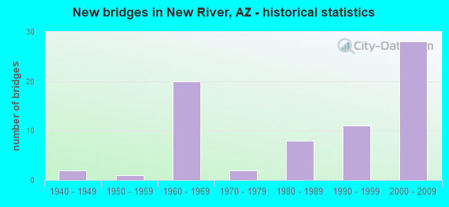
- New bridges - historical statistics
- 21940-1949
- 11950-1959
- 201960-1969
- 21970-1979
- 81980-1989
- 111990-1999
- 282000-2009
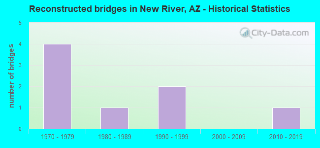
- Reconstructed bridges - Historical Statistics
- 41970-1979
- 11980-1989
- 21990-1999
- 02000-2009
- 12010-2019
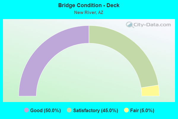
- Bridge Condition - Deck
- 50.0%Good
- 45.0%Satisfactory
- 5.0%Fair
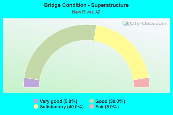
- Bridge Condition - Superstructure
- 5.0%Very good
- 50.0%Good
- 40.0%Satisfactory
- 5.0%Fair
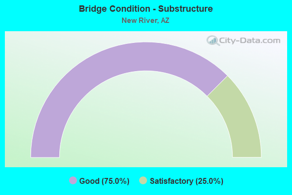
- Bridge Condition - Substructure
- 75.0%Good
- 25.0%Satisfactory
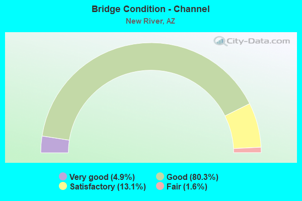
- Bridge Condition - Channel
- 4.9%Very good
- 80.3%Good
- 13.1%Satisfactory
- 1.6%Fair
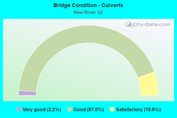
- Bridge Condition - Culverts
- 2.2%Very good
- 87.0%Good
- 10.9%Satisfactory
Find on map >> Show street view
Structure Number: 339, Location: 14.6 mi N Jct SR 74 (Lat: 34.004100, Lng: -112.140900), Route carried "on" structure: Interstate 17, Year Built: 1950, Status: Open, Structure Length: 5.43m (17.81ft), Average Daily Traffic: 20,210 (year 2021), Truck Traffic: 26%, Average Future Daily Traffic: 20,220 (year 2041), Design Load: HS 20, Features Intersected: Moores Gulch
Minimum Vertical Clearance: 30+ m (98+ ft), Kilometerpoint: 383.989, Lanes on structure: 2, Owner: State Highway Agency, Approaching Roadway Width: 11.6m (38.1ft), Skew: 3 degrees, Material/Design: Steel continuous, Design/Construction: Stringer/Multi-beam, Number Of Spans In Main Unit: 3, Length of Maximum Span: 20.4m (66.9ft), Curb-To-Curb Width: 9.7m (31.8ft), Out-to-Out Width: 10.7m (35.1ft)
Condition: Deck: Fair, Superstructure: Fair, Substructure: Good, Channel: Very good, Operating Rating: 44.5 metric tons, Method Used To Determine Operating Rating: Load Factor (LF), Inventory Rating: 26.3 metric tons, Method Used To Determine Inventory Rating: Load Factor (LF), Structural Evaluation: Somewhat better than minimum adequacy, Deck Geometry: High priority of replacement, Waterway Adequacy: Equal to present desirable criteria, Approach Roadway Alignment: Equal to present desirable criteria, Length Of Structure Improvement: 6.95m (22.80ft), Designated Inspection Frequency: Every 24 months, Inspection Date: August 2021, Bridge Improvement Cost: $1,000, Total Project Cost: $1,000 ( Estimate for 2021), Deck Structure Type: Concrete Cast-file-Place, Wearing Surface/Protective System: Wearing Surface: Monolithic Concrete
Find on map >> Show street view
Structure Number: 967, Location: 14.2 mi N Jct SR 74 (Lat: 33.999500, Lng: -112.134000), Route carried "on" structure: Interstate 17, Year Built: 1967, Status: Open, Structure Length: 5.94m (19.49ft), Average Daily Traffic: 22,300 (year 2019), Truck Traffic: 26%, Average Future Daily Traffic: 22,310 (year 2039), Design Load: HS 20, Features Intersected: Moores Gulch
Minimum Vertical Clearance: 30+ m (98+ ft), Kilometerpoint: 383.346, Lanes on structure: 2, Owner: State Highway Agency, Approaching Roadway Width: 11.6m (38.1ft), Material/Design: Steel continuous, Design/Construction: Stringer/Multi-beam, Number Of Spans In Main Unit: 3, Length of Maximum Span: 22.3m (73.2ft), Curb-To-Curb Width: 11.6m (38.1ft), Out-to-Out Width: 12.3m (40.4ft)
Condition: Deck: Good, Superstructure: Good, Substructure: Satisfactory, Channel: Good, Operating Rating: 68.9 metric tons, Method Used To Determine Operating Rating: Load Factor (LF), Inventory Rating: 40.8 metric tons, Method Used To Determine Inventory Rating: Load Factor (LF), Structural Evaluation: Equal to present minimum criteria, Deck Geometry: Equal to present minimum criteria, Waterway Adequacy: Equal to present desirable criteria, Approach Roadway Alignment: Equal to present desirable criteria, Designated Inspection Frequency: Every 24 months, Inspection Date: August 2021, Deck Structure Type: Concrete Cast-file-Place, Wearing Surface/Protective System: Wearing Surface: Bituminous
Find on map >> Show street view
Structure Number: 1289, Location: 1.5 mi North Jct SR 74 (Lat: 33.819800, Lng: -112.141800), Route carried "on" structure: County highway , Year Built: 1968, Status: Open, Structure Length: 6.83m (22.41ft), Average Daily Traffic: 5,000 (year 2020), Truck Traffic: 5%, Average Future Daily Traffic: 5,010 (year 2040), Design Load: HS 20, Features Intersected: I 17, Facility Carried by Structure: Pioneer TI
Minimum Vertical Clearance: 30+ m (98+ ft), Kilometerpoint: 0.000, Lanes on structure: 2, Lanes under structure: 6, Owner: State Highway Agency, Approaching Roadway Width: 9.1m (29.9ft), Material/Design: Steel continuous, Design/Construction: Stringer/Multi-beam, Number Of Spans In Main Unit: 2, Length of Maximum Span: 33.5m (109.9ft), Curb or Sidewalk Widths: Left: 0.5m (1.6ft), Right: 0.5m (1.6ft), Curb-To-Curb Width: 9.1m (29.9ft), Out-to-Out Width: 10.9m (35.8ft)
Condition: Deck: Satisfactory, Superstructure: Satisfactory, Substructure: Good, Operating Rating: 56.2 metric tons, Method Used To Determine Operating Rating: Load Factor (LF), Inventory Rating: 33.6 metric tons, Method Used To Determine Inventory Rating: Load Factor (LF), Structural Evaluation: Equal to present minimum criteria, Deck Geometry: Meets minimum limits, Underclear: Equal to present minimum criteria, Approach Roadway Alignment: Equal to present desirable criteria, Designated Inspection Frequency: Every 24 months, Inspection Date: June 2020, Deck Structure Type: Concrete Cast-file-Place, Wearing Surface/Protective System: Wearing Surface: Monolithic Concrete
Find on map >> Show street view
Structure Number: 129, Location: 7.4 mi North Jct SR 74 (Lat: 33.905300, Lng: -112.146000), Route carried "on" structure: Interstate 17, Year Built: 1968, Year Reconstructed: 1981, Status: Open, Structure Length: 10.58m (34.71ft), Average Daily Traffic: 23,914 (year 2018), Truck Traffic: 13%, Average Future Daily Traffic: 23,924 (year 2038), Design Load: HS 20, Features Intersected: New River
Minimum Vertical Clearance: 30+ m (98+ ft), Kilometerpoint: 372.402, Lanes on structure: 2, Owner: State Highway Agency, Approaching Roadway Width: 11.6m (38.1ft), Skew: 3 degrees, Material/Design: Concrete continuous, Design/Construction: Slab, Number Of Spans In Main Unit: 9, Length of Maximum Span: 12.2m (40.0ft), Curb-To-Curb Width: 12.8m (42.0ft), Out-to-Out Width: 13.8m (45.3ft)
Condition: Deck: Satisfactory, Superstructure: Satisfactory, Substructure: Satisfactory, Channel: Satisfactory, Operating Rating: 54.4 metric tons, Method Used To Determine Operating Rating: Load Factor (LF), Inventory Rating: 32.7 metric tons, Method Used To Determine Inventory Rating: Load Factor (LF), Structural Evaluation: Equal to present minimum criteria, Deck Geometry: Equal to present desirable criteria, Waterway Adequacy: Better than present minimum criteria, Approach Roadway Alignment: Equal to present desirable criteria, Designated Inspection Frequency: Every 24 months, Inspection Date: May 2020, Deck Structure Type: Concrete Cast-file-Place, Wearing Surface/Protective System: Wearing Surface: Bituminous
Find on map >> Show street view
Structure Number: 1291, Location: 7.4 mi North Jct SR 74 (Lat: 33.905200, Lng: -112.146400), Route carried "on" structure: Interstate 17, Year Built: 1968, Year Reconstructed: 1981, Status: Open, Structure Length: 10.58m (34.71ft), Average Daily Traffic: 23,952 (year 2018), Truck Traffic: 13%, Average Future Daily Traffic: 23,962 (year 2038), Design Load: HS 20, Features Intersected: New River
Minimum Vertical Clearance: 30+ m (98+ ft), Kilometerpoint: 372.402, Lanes on structure: 2, Owner: State Highway Agency, Approaching Roadway Width: 11.6m (38.1ft), Skew: 3 degrees, Material/Design: Concrete continuous, Design/Construction: Slab, Number Of Spans In Main Unit: 9, Length of Maximum Span: 12.2m (40.0ft), Curb-To-Curb Width: 12.8m (42.0ft), Out-to-Out Width: 13.8m (45.3ft)
Condition: Deck: Satisfactory, Superstructure: Satisfactory, Substructure: Satisfactory, Channel: Satisfactory, Operating Rating: 54.4 metric tons, Method Used To Determine Operating Rating: Load Factor (LF), Inventory Rating: 32.7 metric tons, Method Used To Determine Inventory Rating: Load Factor (LF), Structural Evaluation: Equal to present minimum criteria, Deck Geometry: Equal to present desirable criteria, Waterway Adequacy: Better than present minimum criteria, Approach Roadway Alignment: Equal to present desirable criteria, Designated Inspection Frequency: Every 24 months, Inspection Date: May 2020, Deck Structure Type: Concrete Cast-file-Place, Wearing Surface/Protective System: Wearing Surface: Bituminous
Find on map >> Show street view
Structure Number: 1292, Location: 8.0 mi N Jct SR 74 (Lat: 33.913500, Lng: -112.145300), Route carried "on" structure: Interstate 17, Year Built: 1968, Status: Open, Structure Length: 4.85m (15.91ft), Average Daily Traffic: 23,352 (year 2017), Truck Traffic: 12%, Average Future Daily Traffic: 23,362 (year 2037), Design Load: HS 20, Features Intersected: Lake Pleasant Road
Minimum Vertical Clearance: 30+ m (98+ ft), Kilometerpoint: 373.400, Lanes on structure: 2, Lanes under structure: 3, Owner: State Highway Agency, Approaching Roadway Width: 11.6m (38.1ft), Skew: 3 degrees, Material/Design: Concrete continuous, Design/Construction: Tee Beam, Number Of Spans In Main Unit: 3, Length of Maximum Span: 18.3m (60.0ft), Curb-To-Curb Width: 11.6m (38.1ft), Out-to-Out Width: 12.4m (40.7ft)
Condition: Deck: Satisfactory, Superstructure: Good, Substructure: Good, Operating Rating: 64.4 metric tons, Method Used To Determine Operating Rating: Load Factor (LF), Inventory Rating: 39.0 metric tons, Method Used To Determine Inventory Rating: Load Factor (LF), Structural Evaluation: Better than present minimum criteria, Deck Geometry: Equal to present minimum criteria, Underclear: Meets minimum limits, Approach Roadway Alignment: Equal to present desirable criteria, Designated Inspection Frequency: Every 24 months, Inspection Date: June 2020, Deck Structure Type: Concrete Cast-file-Place, Wearing Surface/Protective System: Wearing Surface: Bituminous
Find on map >> Show street view
Structure Number: 1293, Location: 8.0 mi N Jct SR 74 (Lat: 33.913400, Lng: -112.145700), Route carried "on" structure: Interstate 17, Year Built: 1968, Status: Open, Structure Length: 4.42m (14.50ft), Average Daily Traffic: 23,401 (year 2017), Truck Traffic: 12%, Average Future Daily Traffic: 23,411 (year 2037), Design Load: HS 20, Features Intersected: New River Road
Minimum Vertical Clearance: 30+ m (98+ ft), Kilometerpoint: 373.400, Lanes on structure: 2, Lanes under structure: 3, Owner: State Highway Agency, Approaching Roadway Width: 11.6m (38.1ft), Skew: 3 degrees, Material/Design: Concrete continuous, Design/Construction: Tee Beam, Number Of Spans In Main Unit: 3, Length of Maximum Span: 18.0m (59.1ft), Curb-To-Curb Width: 11.6m (38.1ft), Out-to-Out Width: 12.4m (40.7ft)
Condition: Deck: Good, Superstructure: Good, Substructure: Good, Operating Rating: 66.2 metric tons, Method Used To Determine Operating Rating: Load Factor (LF), Inventory Rating: 39.0 metric tons, Method Used To Determine Inventory Rating: Load Factor (LF), Structural Evaluation: Better than present minimum criteria, Deck Geometry: Equal to present minimum criteria, Underclear: Meets minimum limits, Approach Roadway Alignment: Equal to present desirable criteria, Designated Inspection Frequency: Every 24 months, Inspection Date: June 2020, Deck Structure Type: Concrete Cast-file-Place, Wearing Surface/Protective System: Wearing Surface: Bituminous
Find on map >> Show street view
Structure Number: 1294, Location: 11.9 mi N Jct SR 74 (Lat: 33.968200, Lng: -112.128400), Route carried "on" structure: County highway , Year Built: 1968, Status: Open, Structure Length: 4.60m (15.09ft), Average Daily Traffic: 300 (year 2018), Truck Traffic: 5%, Average Future Daily Traffic: 310 (year 2038), Design Load: HS 20, Features Intersected: I 17 SB, Facility Carried by Structure: Table Mesa Road
Minimum Vertical Clearance: 30+ m (98+ ft), Kilometerpoint: 0.000, Lanes on structure: 2, Lanes under structure: 2, Owner: State Highway Agency, Approaching Roadway Width: 8.5m (27.9ft), Skew: 3 degrees, Material/Design: Concrete continuous, Design/Construction: Tee Beam, Number Of Spans In Main Unit: 3, Length of Maximum Span: 21.3m (69.9ft), Curb or Sidewalk Widths: Left: 0.5m (1.6ft), Right: 0.5m (1.6ft), Curb-To-Curb Width: 8.5m (27.9ft), Out-to-Out Width: 10.3m (33.8ft)
Condition: Deck: Good, Superstructure: Satisfactory, Substructure: Good, Operating Rating: 59.9 metric tons, Method Used To Determine Operating Rating: Load Factor (LF), Inventory Rating: 35.4 metric tons, Method Used To Determine Inventory Rating: Load Factor (LF), Structural Evaluation: Equal to present minimum criteria, Deck Geometry: Equal to present minimum criteria, Underclear: High priority of corrective action, Approach Roadway Alignment: Equal to present minimum criteria, Designated Inspection Frequency: Every 24 months, Inspection Date: July 2020, Deck Structure Type: Concrete Cast-file-Place, Wearing Surface/Protective System: Wearing Surface: Bituminous
Find on map >> Show street view
Structure Number: 2537, Location: 5.1 mi North Jct SR 74 (Lat: 33.870800, Lng: -112.145700), Route carried "on" structure: County highway , Year Built: 2000, Status: Open, Structure Length: 6.71m (22.01ft), Average Daily Traffic: 19,639 (year 2019), Truck Traffic: 5%, Average Future Daily Traffic: 19,649 (year 2039), Design Load: HS 20, Features Intersected: I 17, Facility Carried by Structure: Anthem Way
Minimum Vertical Clearance: 30+ m (98+ ft), Kilometerpoint: 0.000, Lanes on structure: 9, Lanes under structure: 5, Owner: State Highway Agency, Approaching Roadway Width: 36.6m (120.1ft), Skew: 21 degrees, Material/Design: Prestressed concrete continuous, Design/Construction: Stringer/Multi-beam, Number Of Spans In Main Unit: 2, Length of Maximum Span: 32.6m (107.0ft), Curb or Sidewalk Widths: Left: 2.5m (8.2ft), Right: 2.5m (8.2ft), Curb-To-Curb Width: 36.6m (120.1ft), Out-to-Out Width: 43.3m (142.1ft)
Condition: Deck: Good, Superstructure: Very good, Substructure: Good, Operating Rating: 70.8 metric tons, Method Used To Determine Operating Rating: Load Factor (LF), Inventory Rating: 42.6 metric tons, Method Used To Determine Inventory Rating: Load Factor (LF), Structural Evaluation: Better than present minimum criteria, Deck Geometry: Somewhat better than minimum adequacy, Underclear: Equal to present minimum criteria, Approach Roadway Alignment: Equal to present desirable criteria, Designated Inspection Frequency: Every 24 months, Inspection Date: May 2020, Deck Structure Type: Concrete Cast-file-Place, Wearing Surface/Protective System: Wearing Surface: Monolithic Concrete
Find on map >> Show street view
Structure Number: 2696, Location: 3.0 mi North Jct SR 74 (Lat: 33.839700, Lng: -112.143800), Route carried "on" structure: Ramp Interstate 17, Year Built: 2004, Status: Open, Structure Length: 9.94m (32.61ft), Average Daily Traffic: 7,335 (year 2019), Truck Traffic: 10%, Average Future Daily Traffic: 7,345 (year 2039), Design Load: HS 20, Features Intersected: Deadman Wash, Facility Carried by Structure: Daisy Mtn TI Rmp B
Minimum Vertical Clearance: 5.50m (18.04ft), Kilometerpoint: 365.160, Lanes on structure: 4, Owner: State Highway Agency, Approaching Roadway Width: 14.3m (46.9ft), Skew: 1 degrees, Material/Design: Prestressed concrete continuous, Design/Construction: Stringer/Multi-beam, Number Of Spans In Main Unit: 3, Length of Maximum Span: 32.9m (107.9ft), Curb-To-Curb Width: 14.5m (47.6ft), Out-to-Out Width: 15.4m (50.5ft)
Condition: Deck: Good, Superstructure: Good, Substructure: Good, Channel: Good, Operating Rating: 77.1 metric tons, Method Used To Determine Operating Rating: Load Factor (LF), Inventory Rating: 39.9 metric tons, Method Used To Determine Inventory Rating: Load Factor (LF), Structural Evaluation: Better than present minimum criteria, Deck Geometry: High priority of replacement, Waterway Adequacy: Equal to present desirable criteria, Approach Roadway Alignment: Equal to present desirable criteria, Designated Inspection Frequency: Every 24 months, Inspection Date: May 2020, Deck Structure Type: Concrete Cast-file-Place, Wearing Surface/Protective System: Wearing Surface: Monolithic Concrete
Find on map >> Show street view
Structure Number: 574, Location: 7.2 mi N Jct SR 74 (Lat: 33.901900, Lng: -112.146500), Route carried "on" structure: Interstate 17, Year Built: 1948, Year Reconstructed: 1980, Status: Open, Structure Length: 0.64m (2.10ft), Average Daily Traffic: 46,866 (year 2017), Truck Traffic: 12%, Average Future Daily Traffic: 46,876 (year 2037), Design Load: HS 20, Features Intersected: Wash
Minimum Vertical Clearance: 30+ m (98+ ft), Kilometerpoint: 372.230, Lanes on structure: 4, Owner: State Highway Agency, Approaching Roadway Width: 23.2m (76.1ft), Skew: 21 degrees, Material/Design: Concrete continuous, Design/Construction: Culvert, Number Of Spans In Main Unit: 2, Length of Maximum Span: 3.0m (9.8ft)
Condition: Channel: Good, Culverts: Good, Operating Rating: 60.8 metric tons, Method Used To Determine Operating Rating: Load Factor (LF), Inventory Rating: 36.3 metric tons, Method Used To Determine Inventory Rating: Load Factor (LF), Structural Evaluation: Better than present minimum criteria, Waterway Adequacy: Better than present minimum criteria, Approach Roadway Alignment: Equal to present desirable criteria, Length Of Structure Improvement: 1.37m (4.49ft), Designated Inspection Frequency: Every 48 months, Inspection Date: June 2018, Total Project Cost: $1,000 ( Estimate for 2018)
Find on map >> Show street view
Structure Number: 5742, Location: 8.5 mi N Jct SR 74 (Lat: 33.920000, Lng: -112.144100), Route carried "on" structure: Interstate 17, Year Built: 1968, Status: Open, Structure Length: 0.88m (2.89ft), Average Daily Traffic: 22,100 (year 2017), Truck Traffic: 13%, Average Future Daily Traffic: 22,110 (year 2038), Design Load: HS 20, Features Intersected: Wash
Minimum Vertical Clearance: 30+ m (98+ ft), Kilometerpoint: 374.237, Lanes on structure: 2, Owner: State Highway Agency, Approaching Roadway Width: 11.6m (38.1ft), Skew: 4 degrees, Material/Design: Concrete continuous, Design/Construction: Culvert, Number Of Spans In Main Unit: 2, Length of Maximum Span: 3.0m (9.8ft)
Condition: Channel: Good, Culverts: Good, Operating Rating: 89.8 metric tons, Method Used To Determine Operating Rating: Load Factor (LF), Inventory Rating: 89.8 metric tons, Method Used To Determine Inventory Rating: Load Factor (LF), Structural Evaluation: Better than present minimum criteria, Waterway Adequacy: Better than present minimum criteria, Approach Roadway Alignment: Equal to present desirable criteria, Designated Inspection Frequency: Every 48 months, Inspection Date: August 2018
Find on map >> Show street view
Structure Number: 5743, Location: 8.5 mi N Jct SR 74 (Lat: 33.921100, Lng: -112.144800), Route carried "on" structure: Interstate 17, Year Built: 1968, Status: Open, Structure Length: 0.88m (2.89ft), Average Daily Traffic: 22,571 (year 2017), Truck Traffic: 13%, Average Future Daily Traffic: 22,581 (year 2038), Design Load: HS 20, Features Intersected: Wash
Minimum Vertical Clearance: 30+ m (98+ ft), Kilometerpoint: 374.350, Lanes on structure: 2, Owner: State Highway Agency, Approaching Roadway Width: 11.6m (38.1ft), Skew: 4 degrees, Material/Design: Concrete continuous, Design/Construction: Culvert, Number Of Spans In Main Unit: 2, Length of Maximum Span: 3.0m (9.8ft)
Condition: Channel: Good, Culverts: Good, Operating Rating: 89.8 metric tons, Method Used To Determine Operating Rating: Load Factor (LF), Inventory Rating: 89.8 metric tons, Method Used To Determine Inventory Rating: Load Factor (LF), Structural Evaluation: Better than present minimum criteria, Waterway Adequacy: Equal to present desirable criteria, Approach Roadway Alignment: Equal to present desirable criteria, Designated Inspection Frequency: Every 48 months, Inspection Date: August 2018
Find on map >> Show street view
Structure Number: 5744, Location: 9.9 mi N Jct SR 74 (Lat: 33.939300, Lng: -112.140500), Route carried "on" structure: Interstate 17, Year Built: 1949, Status: Open, Structure Length: 0.73m (2.40ft), Average Daily Traffic: 22,100 (year 2017), Truck Traffic: 13%, Average Future Daily Traffic: 22,110 (year 2038), Design Load: HS 20, Features Intersected: Wash
Minimum Vertical Clearance: 30+ m (98+ ft), Kilometerpoint: 376.490, Lanes on structure: 2, Owner: State Highway Agency, Approaching Roadway Width: 11.6m (38.1ft), Skew: 3 degrees, Material/Design: Concrete continuous, Design/Construction: Culvert, Number Of Spans In Main Unit: 2, Length of Maximum Span: 3.0m (9.8ft)
Condition: Channel: Satisfactory, Culverts: Good, Operating Rating: 89.8 metric tons, Method Used To Determine Operating Rating: Load Factor (LF), Inventory Rating: 89.8 metric tons, Method Used To Determine Inventory Rating: Load Factor (LF), Structural Evaluation: Better than present minimum criteria, Waterway Adequacy: Equal to present minimum criteria, Approach Roadway Alignment: Equal to present desirable criteria, Designated Inspection Frequency: Every 48 months, Inspection Date: August 2018
Find on map >> Show street view
Structure Number: 5745, Location: 9.9 mi N Jct SR 74 (Lat: 33.940800, Lng: -112.141300), Route carried "on" structure: Interstate 17, Year Built: 1968, Status: Open, Structure Length: 0.64m (2.10ft), Average Daily Traffic: 22,571 (year 2017), Truck Traffic: 13%, Average Future Daily Traffic: 22,581 (year 2038), Design Load: HS 20, Features Intersected: Wash
Minimum Vertical Clearance: 30+ m (98+ ft), Kilometerpoint: 376.490, Lanes on structure: 2, Owner: State Highway Agency, Approaching Roadway Width: 11.6m (38.1ft), Material/Design: Concrete continuous, Design/Construction: Culvert, Number Of Spans In Main Unit: 2, Length of Maximum Span: 3.0m (9.8ft)
Condition: Channel: Good, Culverts: Good, Operating Rating: 89.8 metric tons, Method Used To Determine Operating Rating: Load Factor (LF), Inventory Rating: 89.8 metric tons, Method Used To Determine Inventory Rating: Load Factor (LF), Structural Evaluation: Better than present minimum criteria, Waterway Adequacy: Equal to present desirable criteria, Approach Roadway Alignment: Equal to present desirable criteria, Designated Inspection Frequency: Every 48 months, Inspection Date: August 2018
Find on map >> Show street view
Structure Number: 5746, Location: 14.7 mi N Jct SR 74 (Lat: 34.004800, Lng: -112.134100), Route carried "on" structure: Interstate 17, Year Built: 1967, Status: Open, Structure Length: 0.98m (3.22ft), Average Daily Traffic: 19,241 (year 2017), Truck Traffic: 26%, Average Future Daily Traffic: 19,251 (year 2038), Design Load: HS 20, Features Intersected: Wash
Minimum Vertical Clearance: 30+ m (98+ ft), Kilometerpoint: 384.215, Lanes on structure: 2, Owner: State Highway Agency, Approaching Roadway Width: 11.6m (38.1ft), Material/Design: Concrete continuous, Design/Construction: Culvert, Number Of Spans In Main Unit: 3, Length of Maximum Span: 3.0m (9.8ft)
Condition: Channel: Very good, Culverts: Good, Operating Rating: 89.8 metric tons, Method Used To Determine Operating Rating: Load Factor (LF), Inventory Rating: 89.8 metric tons, Method Used To Determine Inventory Rating: Load Factor (LF), Structural Evaluation: Better than present minimum criteria, Waterway Adequacy: Better than present minimum criteria, Approach Roadway Alignment: Equal to present desirable criteria, Designated Inspection Frequency: Every 48 months, Inspection Date: August 2018
Find on map >> Show street view
Structure Number: 7642, Location: At 29th Ave (Lat: 33.921950, Lng: -112.121917), Route carried "on" structure: County highway , Year Built: 1989, Status: Open, Structure Length: 1.71m (5.61ft), Average Daily Traffic: 2,937 (year 2018), Truck Traffic: 10%, Average Future Daily Traffic: 2,947 (year 2038), Design Load: HS 20, Features Intersected: Wash, Facility Carried by Structure: New River Rd
Minimum Vertical Clearance: 30+ m (98+ ft), Kilometerpoint: 0.000, Lanes on structure: 2, Owner: County Highway Agency, Approaching Roadway Width: 8.5m (27.9ft), Skew: 4 degrees, Material/Design: Concrete continuous, Design/Construction: Culvert, Number Of Spans In Main Unit: 3, Length of Maximum Span: 5.5m (18.0ft)
Condition: Channel: Good, Culverts: Good, Inventory Rating: 98.6 metric tons, Method Used To Determine Inventory Rating: Load Factor (LF), Structural Evaluation: Better than present minimum criteria, Waterway Adequacy: Better than present minimum criteria, Approach Roadway Alignment: Equal to present desirable criteria, Designated Inspection Frequency: Every 48 months, Inspection Date: December 2019
Find on map >> Show street view
Structure Number: 7643, Location: 0.21 mi E/ 27th Ave (Lat: 33.922403, Lng: -112.113817), Route carried "on" structure: County highway , Year Built: 1989, Status: Open, Structure Length: 0.67m (2.20ft), Average Daily Traffic: 2,937 (year 2018), Truck Traffic: 10%, Average Future Daily Traffic: 2,947 (year 2038), Design Load: HS 20, Features Intersected: Wash, Facility Carried by Structure: New River Rd
Minimum Vertical Clearance: 30+ m (98+ ft), Kilometerpoint: 0.000, Lanes on structure: 2, Owner: County Highway Agency, Approaching Roadway Width: 8.5m (27.9ft), Skew: 1 degrees, Material/Design: Concrete continuous, Design/Construction: Culvert, Number Of Spans In Main Unit: 2, Length of Maximum Span: 3.4m (11.2ft)
Condition: Channel: Good, Culverts: Good, Inventory Rating: 93.7 metric tons, Method Used To Determine Inventory Rating: Load Factor (LF), Structural Evaluation: Better than present minimum criteria, Waterway Adequacy: Equal to present desirable criteria, Approach Roadway Alignment: Equal to present minimum criteria, Designated Inspection Frequency: Every 48 months, Inspection Date: December 2019
Find on map >> Show street view
Structure Number: 8011, Location: 450' W/ I-17 Frontage Rd (Lat: 33.914428, Lng: -112.142303), Route carried "on" structure: County highway , Year Built: 1968, Year Reconstructed: 1997, Status: Open, Structure Length: 0.64m (2.10ft), Average Daily Traffic: 4,873 (year 2018), Truck Traffic: 10%, Average Future Daily Traffic: 4,883 (year 2038), Design Load: HS 20, Features Intersected: Wash, Facility Carried by Structure: New River Rd
Minimum Vertical Clearance: 30+ m (98+ ft), Kilometerpoint: 0.000, Lanes on structure: 2, Owner: County Highway Agency, Approaching Roadway Width: 8.5m (27.9ft), Material/Design: Concrete continuous, Design/Construction: Culvert, Number Of Spans In Main Unit: 2, Length of Maximum Span: 3.0m (9.8ft), Curb-To-Curb Width: 9.8m (32.2ft), Out-to-Out Width: 9.8m (32.2ft)
Condition: Channel: Good, Culverts: Good, Operating Rating: 49.6 metric tons, Method Used To Determine Operating Rating: Load Factor (LF), Inventory Rating: 29.7 metric tons, Method Used To Determine Inventory Rating: Load Factor (LF), Structural Evaluation: Better than present minimum criteria, Deck Geometry: Meets minimum limits, Waterway Adequacy: Better than present minimum criteria, Approach Roadway Alignment: Equal to present minimum criteria, Designated Inspection Frequency: Every 48 months, Inspection Date: December 2019, Wearing Surface/Protective System: Wearing Surface: Bituminous
Find on map >> Show street view
Structure Number: 864, Location: 0.9 mi S/ New River (Lat: 33.901739, Lng: -112.145878), Route carried "on" structure: County highway , Year Built: 1969, Status: Open, Structure Length: 0.67m (2.20ft), Average Daily Traffic: 2,275 (year 2018), Truck Traffic: 10%, Average Future Daily Traffic: 2,285 (year 2038), Design Load: HS 20, Features Intersected: Wash, Facility Carried by Structure: I-17 Frontage Rd
Minimum Vertical Clearance: 30+ m (98+ ft), Kilometerpoint: 0.000, Lanes on structure: 2, Owner: County Highway Agency, Approaching Roadway Width: 8.5m (27.9ft), Skew: 1 degrees, Material/Design: Concrete continuous, Design/Construction: Culvert, Number Of Spans In Main Unit: 2, Length of Maximum Span: 3.4m (11.2ft)
Condition: Channel: Good, Culverts: Good, Operating Rating: 68.6 metric tons, Method Used To Determine Operating Rating: Load Factor (LF), Inventory Rating: 41.1 metric tons, Method Used To Determine Inventory Rating: Load Factor (LF), Structural Evaluation: Better than present minimum criteria, Waterway Adequacy: Better than present minimum criteria, Approach Roadway Alignment: Equal to present minimum criteria, Designated Inspection Frequency: Every 48 months, Inspection Date: December 2019
Find on map >> Show street view
Structure Number: 9538, Location: 0.8 mi E Jct Central Hwy (Lat: 31.466900, Lng: -109.684600), Route carried "on" structure: County highway , Year Built: 1969, Year Reconstructed: 2010, Status: Open, Structure Length: 1.31m (4.30ft), Average Daily Traffic: 4,500 (year 2017), Truck Traffic: 5%, Average Future Daily Traffic: 4,510 (year 2039), Design Load: HS 20, Features Intersected: Desert Wash, Facility Carried by Structure: Double Adobe Rd
Minimum Vertical Clearance: 30+ m (98+ ft), Kilometerpoint: 0.000, Lanes on structure: 2, Owner: County Highway Agency, Approaching Roadway Width: 11.0m (36.1ft), Material/Design: Concrete continuous, Design/Construction: Culvert, Number Of Spans In Main Unit: 4, Length of Maximum Span: 3.0m (9.8ft), Curb or Sidewalk Widths: Left: 0.3m (1.0ft), Right: 0.3m (1.0ft), Curb-To-Curb Width: 13.7m (44.9ft), Out-to-Out Width: 14.3m (46.9ft)
Condition: Channel: Good, Culverts: Good, Operating Rating: 52.6 metric tons, Method Used To Determine Operating Rating: Load Factor (LF), Inventory Rating: 31.8 metric tons, Method Used To Determine Inventory Rating: Load Factor (LF), Structural Evaluation: Better than present minimum criteria, Deck Geometry: Superior to present desirable criteria, Waterway Adequacy: Equal to present desirable criteria, Approach Roadway Alignment: Equal to present desirable criteria, Designated Inspection Frequency: Every 48 months, Inspection Date: January 2019, Deck Structure Type: Concrete Cast-file-Place, Wearing Surface/Protective System: Wearing Surface: Bituminous
Find on map >> Show street view
Structure Number: 9613, Location: 0.1 mi S Jct Dbl Adobe Rd (Lat: 31.465100, Lng: -109.698400), Route carried "on" structure: County highway , Year Built: 1980, Status: Open, Structure Length: 4.05m (13.29ft), Average Daily Traffic: 800 (year 2021), Truck Traffic: 3%, Average Future Daily Traffic: 810 (year 2041), Design Load: HS 20, Features Intersected: Whitewater Draw, Facility Carried by Structure: Central Hwy
Minimum Vertical Clearance: 30+ m (98+ ft), Kilometerpoint: 0.000, Lanes on structure: 2, Owner: County Highway Agency, Approaching Roadway Width: 11.6m (38.1ft), Skew: 3 degrees, Material/Design: Concrete continuous, Design/Construction: Tee Beam, Number Of Spans In Main Unit: 3, Length of Maximum Span: 15.2m (49.9ft), Curb-To-Curb Width: 11.6m (38.1ft), Out-to-Out Width: 12.6m (41.3ft)
Condition: Deck: Satisfactory, Superstructure: Satisfactory, Substructure: Good, Channel: Good, Operating Rating: 51.7 metric tons, Method Used To Determine Operating Rating: Load Factor (LF), Inventory Rating: 32.7 metric tons, Method Used To Determine Inventory Rating: Load Factor (LF), Structural Evaluation: Equal to present minimum criteria, Deck Geometry: Better than present minimum criteria, Waterway Adequacy: Equal to present desirable criteria, Approach Roadway Alignment: Equal to present desirable criteria, Designated Inspection Frequency: Every 24 months, Inspection Date: Febuary 2021, Deck Structure Type: Concrete Cast-file-Place, Wearing Surface/Protective System: Wearing Surface: Monolithic Concrete
Find on map >> Show street view
Structure Number: 9615, Location: 0.1 mi S Jct Ajo Way (Lat: 32.175917, Lng: -111.003056), Route carried "on" structure: City street , Year Built: 1969, Year Reconstructed: 1977, Status: Open, Structure Length: 1.52m (4.99ft), Average Daily Traffic: 7,936 (year 2014), Truck Traffic: 5%, Average Future Daily Traffic: 7,946 (year 2039), Design Load: HS 20, Features Intersected: Ajo Wash, Facility Carried by Structure: Mission Road
Minimum Vertical Clearance: 30+ m (98+ ft), Kilometerpoint: 0.000, Lanes on structure: 4, Owner: City or Municipal Highway Agency, Approaching Roadway Width: 28.0m (91.9ft), Skew: 22 degrees, Material/Design: Concrete continuous, Design/Construction: Culvert, Number Of Spans In Main Unit: 4, Length of Maximum Span: 3.0m (9.8ft), Curb or Sidewalk Widths: Left: 2.9m (9.5ft), Right: 3.2m (10.5ft), Curb-To-Curb Width: 28.0m (91.9ft), Out-to-Out Width: 34.7m (113.8ft)
Condition: Channel: Satisfactory, Culverts: Good, Operating Rating: 49.0 metric tons, Method Used To Determine Operating Rating: Load Factor (LF), Inventory Rating: 29.0 metric tons, Method Used To Determine Inventory Rating: Load Factor (LF), Structural Evaluation: Better than present minimum criteria, Deck Geometry: Superior to present desirable criteria, Waterway Adequacy: Equal to present desirable criteria, Approach Roadway Alignment: Equal to present desirable criteria, Designated Inspection Frequency: Every 48 months, Inspection Date: April 2019, Deck Structure Type: Concrete Cast-file-Place, Wearing Surface/Protective System: Wearing Surface: Bituminous
Find on map >> Show street view
Structure Number: 9823, Location: 0.5 mi W of Power Rd (Lat: 33.379333, Lng: -111.696667), Route carried "on" structure: City street , Year Built: 1983, Status: Open, Structure Length: 4.57m (14.99ft), Average Daily Traffic: 19,867 (year 2019), Truck Traffic: 10%, Average Future Daily Traffic: 19,877 (year 2039), Design Load: HS 20, Features Intersected: RWCD Floodway, Facility Carried by Structure: Baseline Road
Minimum Vertical Clearance: 30+ m (98+ ft), Kilometerpoint: 0.000, Lanes on structure: 4, Owner: Town or Township Highway Agency, Approaching Roadway Width: 20.7m (67.9ft), Skew: 2 degrees, Material/Design: Concrete continuous, Design/Construction: Slab, Number Of Spans In Main Unit: 6, Length of Maximum Span: 10.1m (33.1ft), Curb or Sidewalk Widths: Left: 2.4m (7.9ft), Right: 0.0m, Curb-To-Curb Width: 20.7m (67.9ft), Out-to-Out Width: 24.4m (80.1ft)
Condition: Deck: Satisfactory, Superstructure: Satisfactory, Substructure: Good, Channel: Fair, Operating Rating: 54.4 metric tons, Method Used To Determine Operating Rating: Field evaluation and documented engineering judgment, Inventory Rating: 32.7 metric tons, Method Used To Determine Inventory Rating: Field evaluation and documented engineering judgment, Structural Evaluation: Equal to present minimum criteria, Deck Geometry: Superior to present desirable criteria, Waterway Adequacy: Equal to present desirable criteria, Approach Roadway Alignment: Equal to present desirable criteria, Designated Inspection Frequency: Every 24 months, Inspection Date: November 2020, Deck Structure Type: Concrete Cast-file-Place, Wearing Surface/Protective System: Wearing Surface: Monolithic Concrete
Find on map >> Show street view
Structure Number: 9824, Location: 1.7 mi N/ Thomas (Lat: 33.504989, Lng: -111.684133), Route carried "on" structure: County highway , Year Built: 1983, Status: Open, Structure Length: 3.19m (10.47ft), Average Daily Traffic: 2,952 (year 2019), Truck Traffic: 10%, Average Future Daily Traffic: 2,962 (year 2039), Design Load: HS 20, Features Intersected: FanninMcFar CAP Aqueduct, Facility Carried by Structure: Bush Hwy
Minimum Vertical Clearance: 30+ m (98+ ft), Kilometerpoint: 0.000, Lanes on structure: 2, Owner: County Highway Agency, Approaching Roadway Width: 12.2m (40.0ft), Skew: 1 degrees, Material/Design: Prestressed concrete, Design/Construction: Stringer/Multi-beam, Number Of Spans In Main Unit: 1, Length of Maximum Span: 31.4m (103.0ft), Curb or Sidewalk Widths: Left: 0.0m, Right: 2.4m (7.9ft), Curb-To-Curb Width: 20.7m (67.9ft), Out-to-Out Width: 24.2m (79.4ft)
Condition: Deck: Satisfactory, Superstructure: Good, Substructure: Satisfactory, Channel: Good, Inventory Rating: 51.2 metric tons, Method Used To Determine Inventory Rating: Load Factor (LF), Structural Evaluation: Equal to present minimum criteria, Deck Geometry: Superior to present desirable criteria, Waterway Adequacy: Equal to present desirable criteria, Approach Roadway Alignment: Equal to present minimum criteria, Designated Inspection Frequency: Every 24 months, Inspection Date: March 2020, Deck Structure Type: Concrete Cast-file-Place, Wearing Surface/Protective System: Wearing Surface: Monolithic Concrete
Find on map >> Show street view
Structure Number: 9825, Location: 2 miles W/ Cave Creek Rd (Lat: 33.799203, Lng: -111.995758), Route carried "on" structure: County highway , Year Built: 1986, Status: Open, Structure Length: 10.79m (35.40ft), Average Daily Traffic: 9,194 (year 2020), Truck Traffic: 10%, Average Future Daily Traffic: 9,204 (year 2040), Design Load: HS 20, Features Intersected: Cave Creek Wash, Facility Carried by Structure: Carefree Hwy WB
Minimum Vertical Clearance: 30+ m (98+ ft), Kilometerpoint: 0.000, Lanes on structure: 2, Owner: County Highway Agency, Approaching Roadway Width: 9.1m (29.9ft), Skew: 3 degrees, Material/Design: Prestressed concrete continuous, Design/Construction: Stringer/Multi-beam, Number Of Spans In Main Unit: 4, Length of Maximum Span: 26.8m (87.9ft), Curb-To-Curb Width: 11.0m (36.1ft), Out-to-Out Width: 11.9m (39.0ft)
Condition: Deck: Good, Superstructure: Good, Substructure: Good, Channel: Good, Operating Rating: 85.6 metric tons, Method Used To Determine Operating Rating: Load Factor (LF), Inventory Rating: 36.5 metric tons, Method Used To Determine Inventory Rating: Load Factor (LF), Structural Evaluation: Better than present minimum criteria, Deck Geometry: Equal to present minimum criteria, Waterway Adequacy: Equal to present desirable criteria, Approach Roadway Alignment: Equal to present desirable criteria, Designated Inspection Frequency: Every 24 months, Inspection Date: October 2021, Deck Structure Type: Concrete Cast-file-Place, Wearing Surface/Protective System: Wearing Surface: Epoxy Overlay
Find on map >> Show street view
Structure Number: 9872, Location: 0.1 mi E Silverbell Rd (Lat: 32.250600, Lng: -111.011900), Route carried "on" structure: City street , Year Built: 1979, Status: Open, Structure Length: 0.64m (2.10ft), Average Daily Traffic: 24,583 (year 2020), Truck Traffic: 10%, Average Future Daily Traffic: 24,593 (year 2040), Design Load: HS 20, Features Intersected: Brichta Wash, Facility Carried by Structure: Grant Road
Minimum Vertical Clearance: 9.14m (29.99ft), Kilometerpoint: 0.000, Lanes on structure: 5, Owner: City or Municipal Highway Agency, Approaching Roadway Width: 23.2m (76.1ft), Material/Design: Concrete continuous, Design/Construction: Culvert, Number Of Spans In Main Unit: 2, Length of Maximum Span: 3.0m (9.8ft), Curb or Sidewalk Widths: Left: 1.5m (4.9ft), Right: 1.5m (4.9ft), Curb-To-Curb Width: 23.2m (76.1ft), Out-to-Out Width: 28.3m (92.8ft)
Condition: Channel: Good, Culverts: Good, Operating Rating: 52.6 metric tons, Method Used To Determine Operating Rating: Load Factor (LF), Inventory Rating: 31.8 metric tons, Method Used To Determine Inventory Rating: Load Factor (LF), Structural Evaluation: Better than present minimum criteria, Deck Geometry: Better than present minimum criteria, Waterway Adequacy: Better than present minimum criteria, Approach Roadway Alignment: Equal to present desirable criteria, Designated Inspection Frequency: Every 48 months, Inspection Date: August 2021, Deck Structure Type: Concrete Cast-file-Place, Wearing Surface/Protective System: Wearing Surface: Bituminous
Find on map >> Show street view
Structure Number: 9873, Location: 200' N Speedway Blvd (Lat: 32.236600, Lng: -111.021500), Route carried "on" structure: City street , Year Built: 1980, Status: Open, Structure Length: 1.74m (5.71ft), Average Daily Traffic: 6,342 (year 2020), Truck Traffic: 5%, Average Future Daily Traffic: 6,352 (year 2040), Design Load: HS 20, Features Intersected: Anklam Wash, Facility Carried by Structure: Greasewood Rd
Minimum Vertical Clearance: 30+ m (98+ ft), Kilometerpoint: 0.000, Lanes on structure: 2, Owner: City or Municipal Highway Agency, Approaching Roadway Width: 10.7m (35.1ft), Skew: 2 degrees, Material/Design: Concrete continuous, Design/Construction: Culvert, Number Of Spans In Main Unit: 4, Length of Maximum Span: 3.7m (12.1ft), Curb or Sidewalk Widths: Left: 0.0m, Right: 1.8m (5.9ft)
Condition: Channel: Good, Culverts: Good, Operating Rating: 64.4 metric tons, Method Used To Determine Operating Rating: Load Factor (LF), Inventory Rating: 38.1 metric tons, Method Used To Determine Inventory Rating: Load Factor (LF), Structural Evaluation: Better than present minimum criteria, Waterway Adequacy: Better than present minimum criteria, Approach Roadway Alignment: Better than present minimum criteria, Designated Inspection Frequency: Every 48 months, Inspection Date: August 2021
Find on map >> Show street view
Structure Number: 9882, Location: 0.3 mi E Jct Higley Rd (Lat: 33.408400, Lng: -111.713500), Route carried "on" structure: City street , Year Built: 1970, Year Reconstructed: 1984, Status: Open, Structure Length: 1.19m (3.90ft), Average Daily Traffic: 15,727 (year 2019), Truck Traffic: 5%, Average Future Daily Traffic: 15,737 (year 2039), Design Load: HS 20, Features Intersected: RWCD Canal, Facility Carried by Structure: Broadway Road
Minimum Vertical Clearance: 9.14m (29.99ft), Kilometerpoint: 0.000, Lanes on structure: 5, Owner: City or Municipal Highway Agency, Approaching Roadway Width: 20.7m (67.9ft), Skew: 3 degrees, Material/Design: Prestressed concrete, Design/Construction: Box Beam or Girders - Multiple, Number Of Spans In Main Unit: 1, Length of Maximum Span: 11.0m (36.1ft), Curb or Sidewalk Widths: Left: 1.5m (4.9ft), Right: 1.5m (4.9ft), Curb-To-Curb Width: 20.7m (67.9ft), Out-to-Out Width: 25.0m (82.0ft)
Condition: Deck: Good, Superstructure: Good, Substructure: Good, Channel: Good, Operating Rating: 41.7 metric tons, Method Used To Determine Operating Rating: Load Factor (LF), Inventory Rating: 24.5 metric tons, Method Used To Determine Inventory Rating: Load Factor (LF), Structural Evaluation: Equal to present minimum criteria, Deck Geometry: Somewhat better than minimum adequacy, Waterway Adequacy: Equal to present desirable criteria, Approach Roadway Alignment: Equal to present desirable criteria, Designated Inspection Frequency: Every 24 months, Inspection Date: January 2022, Deck Structure Type: Concrete Cast-file-Place, Wearing Surface/Protective System: Wearing Surface: Bituminous
Find on map >> Show street view
Structure Number: 9893, Location: 250' W/ 24th St (Lat: 33.799175, Lng: -112.031275), Route carried "on" structure: County highway , Year Built: 1985, Year Reconstructed: 1998, Status: Open, Structure Length: 0.98m (3.22ft), Average Daily Traffic: 13,867 (year 2017), Truck Traffic: 10%, Average Future Daily Traffic: 13,877 (year 2037), Design Load: HS 20, Features Intersected: Wash, Facility Carried by Structure: Carefree Hwy
Minimum Vertical Clearance: 30+ m (98+ ft), Kilometerpoint: 0.000, Lanes on structure: 5, Owner: County Highway Agency, Approaching Roadway Width: 19.5m (64.0ft), Skew: 20 degrees, Material/Design: Concrete continuous, Design/Construction: Culvert, Number Of Spans In Main Unit: 3, Length of Maximum Span: 3.0m (9.8ft), Curb-To-Curb Width: 19.5m (64.0ft), Out-to-Out Width: 19.5m (64.0ft)
Condition: Channel: Satisfactory, Culverts: Satisfactory, Operating Rating: 55.4 metric tons, Method Used To Determine Operating Rating: Load Factor (LF), Inventory Rating: 33.2 metric tons, Method Used To Determine Inventory Rating: Load Factor (LF), Structural Evaluation: Equal to present minimum criteria, Deck Geometry: Meets minimum limits, Waterway Adequacy: Better than present minimum criteria, Approach Roadway Alignment: Equal to present desirable criteria, Designated Inspection Frequency: Every 48 months, Inspection Date: October 2018, Wearing Surface/Protective System: Wearing Surface: Bituminous
Find on map >> Show street view
Structure Number: 10021, Location: 0.75 mi N/Venado Dr (Lat: 33.907081, Lng: -112.083889), Route carried "on" structure: County highway , Year Built: 1995, Status: Open, Structure Length: 11.19m (36.71ft), Average Daily Traffic: 2,707 (year 2020), Truck Traffic: 5%, Average Future Daily Traffic: 2,717 (year 2040), Design Load: HS 20, Features Intersected: Skunk Creek, Facility Carried by Structure: New River Rd
Minimum Vertical Clearance: 30+ m (98+ ft), Kilometerpoint: 0.000, Lanes on structure: 2, Owner: County Highway Agency, Approaching Roadway Width: 8.5m (27.9ft), Skew: 5 degrees, Material/Design: Concrete continuous, Design/Construction: Slab, Number Of Spans In Main Unit: 5, Length of Maximum Span: 24.1m (79.1ft), Curb or Sidewalk Widths: Left: 1.8m (5.9ft), Right: 1.8m (5.9ft), Curb-To-Curb Width: 20.7m (67.9ft), Out-to-Out Width: 25.6m (84.0ft)
Condition: Deck: Satisfactory, Superstructure: Satisfactory, Substructure: Satisfactory, Channel: Satisfactory, Operating Rating: 64.0 metric tons, Method Used To Determine Operating Rating: Load Factor (LF), Inventory Rating: 38.4 metric tons, Method Used To Determine Inventory Rating: Load Factor (LF), Structural Evaluation: Equal to present minimum criteria, Deck Geometry: Superior to present desirable criteria, Waterway Adequacy: Equal to present minimum criteria, Approach Roadway Alignment: Equal to present minimum criteria, Designated Inspection Frequency: Every 24 months, Inspection Date: October 2021, Deck Structure Type: Concrete Cast-file-Place, Wearing Surface/Protective System: Wearing Surface: Epoxy Overlay
Find on map >> Show street view
Structure Number: 1005, Location: 0.2 mi N/ Carefree Hwy (Lat: 33.802000, Lng: -112.065400), Route carried "on" structure: County highway , Year Built: 1996, Status: Open, Structure Length: 4.11m (13.48ft), Average Daily Traffic: 8,677 (year 2017), Truck Traffic: 10%, Average Future Daily Traffic: 8,687 (year 2035), Design Load: HS 20, Features Intersected: Desert Lake Wash, Facility Carried by Structure: 7th St
Minimum Vertical Clearance: 30+ m (98+ ft), Kilometerpoint: 0.000, Lanes on structure: 2, Owner: County Highway Agency, Approaching Roadway Width: 14.6m (47.9ft), Skew: 5 degrees, Material/Design: Concrete continuous, Design/Construction: Culvert, Number Of Spans In Main Unit: 6, Length of Maximum Span: 6.4m (21.0ft)
Condition: Channel: Good, Culverts: Good, Operating Rating: 68.7 metric tons, Method Used To Determine Operating Rating: Load Factor (LF), Inventory Rating: 41.2 metric tons, Method Used To Determine Inventory Rating: Load Factor (LF), Structural Evaluation: Better than present minimum criteria, Waterway Adequacy: Equal to present desirable criteria, Approach Roadway Alignment: Equal to present desirable criteria, Designated Inspection Frequency: Every 48 months, Inspection Date: October 2018
Find on map >> Show street view
Structure Number: 10051, Location: N/ Carefree Hwy (Lat: 33.800300, Lng: -112.065411), Route carried "on" structure: County highway , Year Built: 1996, Status: Open, Structure Length: 1.34m (4.40ft), Average Daily Traffic: 8,677 (year 2017), Truck Traffic: 10%, Average Future Daily Traffic: 8,687 (year 2037), Design Load: HS 20, Features Intersected: Desert Lk Wash S Branch, Facility Carried by Structure: 7th St
Minimum Vertical Clearance: 30+ m (98+ ft), Kilometerpoint: 0.000, Lanes on structure: 2, Owner: County Highway Agency, Approaching Roadway Width: 14.6m (47.9ft), Skew: 5 degrees, Material/Design: Concrete continuous, Design/Construction: Culvert, Number Of Spans In Main Unit: 2, Length of Maximum Span: 6.4m (21.0ft)
Condition: Channel: Good, Culverts: Good, Operating Rating: 86.1 metric tons, Method Used To Determine Operating Rating: Load Factor (LF), Inventory Rating: 51.5 metric tons, Method Used To Determine Inventory Rating: Load Factor (LF), Structural Evaluation: Better than present minimum criteria, Waterway Adequacy: Better than present minimum criteria, Approach Roadway Alignment: Equal to present desirable criteria, Designated Inspection Frequency: Every 48 months, Inspection Date: October 2018
Find on map >> Show street view
Structure Number: 10083, Location: S and N/ Circle Mtn Rd (Lat: 33.885767, Lng: -112.072628), Route carried "on" structure: County highway , Year Built: 1996, Status: Open, Structure Length: 6.74m (22.11ft), Average Daily Traffic: 2,707 (year 2020), Truck Traffic: 5%, Average Future Daily Traffic: 2,717 (year 2040), Design Load: HS 20, Features Intersected: Cline Creek Wash, Facility Carried by Structure: New River Road
Minimum Vertical Clearance: 30+ m (98+ ft), Kilometerpoint: 0.000, Lanes on structure: 3, Owner: County Highway Agency, Approaching Roadway Width: 8.5m (27.9ft), Material/Design: Concrete continuous, Design/Construction: Slab, Number Of Spans In Main Unit: 4, Length of Maximum Span: 18.6m (61.0ft), Curb or Sidewalk Widths: Left: 1.8m (5.9ft), Right: 1.8m (5.9ft), Curb-To-Curb Width: 20.7m (67.9ft), Out-to-Out Width: 25.6m (84.0ft)
Condition: Deck: Satisfactory, Superstructure: Satisfactory, Substructure: Good, Channel: Good, Inventory Rating: 60.5 metric tons, Method Used To Determine Inventory Rating: Load Factor (LF), Structural Evaluation: Equal to present minimum criteria, Deck Geometry: Superior to present desirable criteria, Waterway Adequacy: Better than present minimum criteria, Approach Roadway Alignment: Equal to present desirable criteria, Designated Inspection Frequency: Every 24 months, Inspection Date: October 2021, Deck Structure Type: Concrete Cast-file-Place, Wearing Surface/Protective System: Wearing Surface: Epoxy Overlay
Find on map >> Show street view
Structure Number: 10084, Location: 0.6 mi E/ New River Rd (Lat: 33.886908, Lng: -112.063272), Route carried "on" structure: County highway , Year Built: 1996, Status: Open, Structure Length: 3.08m (10.10ft), Average Daily Traffic: 4,166 (year 2018), Truck Traffic: 2%, Average Future Daily Traffic: 4,176 (year 2038), Design Load: HS 20, Features Intersected: Wash, Facility Carried by Structure: Circle Mtn Road
Minimum Vertical Clearance: 30+ m (98+ ft), Kilometerpoint: 0.000, Lanes on structure: 2, Owner: County Highway Agency, Approaching Roadway Width: 8.5m (27.9ft), Skew: 6 degrees, Material/Design: Concrete continuous, Design/Construction: Culvert, Number Of Spans In Main Unit: 2, Length of Maximum Span: 15.2m (49.9ft), Curb-To-Curb Width: 9.8m (32.2ft), Out-to-Out Width: 9.8m (32.2ft)
Condition: Channel: Satisfactory, Culverts: Satisfactory, Operating Rating: 39.2 metric tons, Method Used To Determine Operating Rating: Load Factor (LF), Inventory Rating: 32.7 metric tons, Method Used To Determine Inventory Rating: Load Factor (LF), Structural Evaluation: Equal to present minimum criteria, Deck Geometry: Meets minimum limits, Waterway Adequacy: Equal to present minimum criteria, Approach Roadway Alignment: Equal to present minimum criteria, Designated Inspection Frequency: Every 48 months, Inspection Date: October 2019, Wearing Surface/Protective System: Wearing Surface: Bituminous
Find on map >> Show street view
Structure Number: 10085, Location: 0.2 mi S/ New River Rd (Lat: 33.911525, Lng: -112.141069), Route carried "on" structure: County highway , Year Built: 1997, Status: Open, Structure Length: 12.22m (40.09ft), Average Daily Traffic: 2,454 (year 2020), Truck Traffic: 5%, Average Future Daily Traffic: 2,464 (year 2040), Design Load: HS 20, Features Intersected: New River, Facility Carried by Structure: I-17 Frontage Rd
Minimum Vertical Clearance: 30+ m (98+ ft), Kilometerpoint: 0.000, Lanes on structure: 2, Owner: County Highway Agency, Approaching Roadway Width: 12.2m (40.0ft), Skew: 2 degrees, Material/Design: Prestressed concrete continuous, Design/Construction: Stringer/Multi-beam, Number Of Spans In Main Unit: 5, Length of Maximum Span: 24.4m (80.1ft), Curb or Sidewalk Widths: Left: 1.8m (5.9ft), Right: 1.8m (5.9ft), Curb-To-Curb Width: 15.8m (51.8ft), Out-to-Out Width: 21.0m (68.9ft)
Condition: Deck: Good, Superstructure: Good, Substructure: Good, Channel: Good, Operating Rating: 61.6 metric tons, Method Used To Determine Operating Rating: Load Factor (LF), Inventory Rating: 36.6 metric tons, Method Used To Determine Inventory Rating: Load Factor (LF), Structural Evaluation: Better than present minimum criteria, Deck Geometry: Superior to present desirable criteria, Waterway Adequacy: Equal to present desirable criteria, Approach Roadway Alignment: Equal to present minimum criteria, Designated Inspection Frequency: Every 24 months, Inspection Date: December 2021, Deck Structure Type: Concrete Cast-file-Place, Wearing Surface/Protective System: Wearing Surface: Epoxy Overlay
Find on map >> Show street view
Structure Number: 10106, Location: E of I-17 Frontage Rd (Lat: 33.918336, Lng: -112.138703), Route carried "on" structure: County highway , Year Built: 1997, Status: Open, Structure Length: 12.41m (40.72ft), Average Daily Traffic: 5,477 (year 2020), Truck Traffic: 5%, Average Future Daily Traffic: 5,487 (year 2040), Design Load: HS 20, Features Intersected: New River, Facility Carried by Structure: New River Road
Minimum Vertical Clearance: 30+ m (98+ ft), Kilometerpoint: 0.000, Lanes on structure: 3, Owner: County Highway Agency, Approaching Roadway Width: 8.5m (27.9ft), Material/Design: Prestressed concrete continuous, Design/Construction: Stringer/Multi-beam, Number Of Spans In Main Unit: 4, Length of Maximum Span: 30.5m (100.1ft), Curb or Sidewalk Widths: Left: 1.8m (5.9ft), Right: 1.8m (5.9ft), Curb-To-Curb Width: 20.7m (67.9ft), Out-to-Out Width: 25.8m (84.6ft)
Condition: Deck: Good, Superstructure: Good, Substructure: Good, Channel: Good, Operating Rating: 61.6 metric tons, Method Used To Determine Operating Rating: Load Factor (LF), Inventory Rating: 36.6 metric tons, Method Used To Determine Inventory Rating: Load Factor (LF), Structural Evaluation: Better than present minimum criteria, Deck Geometry: Superior to present desirable criteria, Waterway Adequacy: Equal to present desirable criteria, Approach Roadway Alignment: Equal to present minimum criteria, Designated Inspection Frequency: Every 24 months, Inspection Date: December 2021, Deck Structure Type: Concrete Cast-file-Place, Wearing Surface/Protective System: Wearing Surface: Epoxy Overlay
Find on map >> Show street view
Structure Number: 10158, Location: W/ 16th Street (Lat: 33.799114, Lng: -112.049325), Route carried "on" structure: County highway , Year Built: 1998, Status: Open, Structure Length: 0.64m (2.10ft), Average Daily Traffic: 14,900 (year 2017), Truck Traffic: 10%, Average Future Daily Traffic: 14,910 (year 2037), Design Load: HS 20, Features Intersected: Wash, Facility Carried by Structure: Carefree Highway
Minimum Vertical Clearance: 30+ m (98+ ft), Kilometerpoint: 0.000, Lanes on structure: 5, Owner: County Highway Agency, Approaching Roadway Width: 19.5m (64.0ft), Skew: 20 degrees, Material/Design: Concrete continuous, Design/Construction: Culvert, Number Of Spans In Main Unit: 2, Length of Maximum Span: 3.0m (9.8ft), Curb-To-Curb Width: 23.8m (78.1ft), Out-to-Out Width: 23.8m (78.1ft)
Condition: Channel: Good, Culverts: Satisfactory, Operating Rating: 64.9 metric tons, Method Used To Determine Operating Rating: Load Factor (LF), Inventory Rating: 38.8 metric tons, Method Used To Determine Inventory Rating: Load Factor (LF), Structural Evaluation: Equal to present minimum criteria, Deck Geometry: Better than present minimum criteria, Waterway Adequacy: Better than present minimum criteria, Approach Roadway Alignment: Equal to present desirable criteria, Designated Inspection Frequency: Every 48 months, Inspection Date: October 2018, Wearing Surface/Protective System: Wearing Surface: Bituminous
Find on map >> Show street view
Structure Number: 10159, Location: 0.5 mi W/ 24th Street (Lat: 33.799150, Lng: -112.038994), Route carried "on" structure: County highway , Year Built: 1998, Status: Open, Structure Length: 0.64m (2.10ft), Average Daily Traffic: 14,544 (year 2017), Truck Traffic: 10%, Average Future Daily Traffic: 14,554 (year 2037), Design Load: HS 20, Features Intersected: Wash, Facility Carried by Structure: Carefree Highway
Minimum Vertical Clearance: 30+ m (98+ ft), Kilometerpoint: 0.000, Lanes on structure: 4, Owner: County Highway Agency, Approaching Roadway Width: 19.5m (64.0ft), Skew: 21 degrees, Material/Design: Concrete continuous, Design/Construction: Culvert, Number Of Spans In Main Unit: 2, Length of Maximum Span: 3.0m (9.8ft), Curb-To-Curb Width: 20.7m (67.9ft), Out-to-Out Width: 20.7m (67.9ft)
Condition: Channel: Good, Culverts: Good, Operating Rating: 62.7 metric tons, Method Used To Determine Operating Rating: Load Factor (LF), Inventory Rating: 37.6 metric tons, Method Used To Determine Inventory Rating: Load Factor (LF), Structural Evaluation: Better than present minimum criteria, Deck Geometry: Superior to present desirable criteria, Waterway Adequacy: Equal to present minimum criteria, Approach Roadway Alignment: Equal to present desirable criteria, Designated Inspection Frequency: Every 48 months, Inspection Date: October 2018, Wearing Surface/Protective System: Wearing Surface: Bituminous
Find on map >> Show street view
Structure Number: 1016, Location: 0.21 mi E/ 24th Street (Lat: 33.799186, Lng: -112.026756), Route carried "on" structure: County highway , Year Built: 1998, Status: Open, Structure Length: 0.94m (3.08ft), Average Daily Traffic: 15,404 (year 2017), Truck Traffic: 10%, Average Future Daily Traffic: 15,414 (year 2037), Design Load: HS 20, Features Intersected: Wash, Facility Carried by Structure: Carefree Highway
Minimum Vertical Clearance: 30+ m (98+ ft), Kilometerpoint: 0.000, Lanes on structure: 4, Owner: County Highway Agency, Approaching Roadway Width: 19.5m (64.0ft), Skew: 20 degrees, Material/Design: Concrete continuous, Design/Construction: Culvert, Number Of Spans In Main Unit: 3, Length of Maximum Span: 3.0m (9.8ft)
Condition: Channel: Good, Culverts: Satisfactory, Inventory Rating: 74.7 metric tons, Method Used To Determine Inventory Rating: Load Factor (LF), Structural Evaluation: Equal to present minimum criteria, Waterway Adequacy: Better than present minimum criteria, Approach Roadway Alignment: Equal to present desirable criteria, Designated Inspection Frequency: Every 48 months, Inspection Date: October 2018
Find on map >> Show street view
Structure Number: 10369, Location: 0.2 Mi E/GavilanPeakPkwy (Lat: 33.856797, Lng: -112.134225), Route carried "on" structure: County highway , Year Built: 1998, Status: Open, Structure Length: 0.82m (2.69ft), Average Daily Traffic: 1,824 (year 2020), Average Future Daily Traffic: 1,834 (year 2040), Design Load: HS 20, Features Intersected: Wash, Facility Carried by Structure: Whitman Drive
Minimum Vertical Clearance: 30+ m (98+ ft), Kilometerpoint: 0.000, Lanes on structure: 2, Owner: County Highway Agency, Approaching Roadway Width: 14.6m (47.9ft), Skew: 1 degrees, Material/Design: Concrete continuous, Design/Construction: Culvert, Number Of Spans In Main Unit: 3, Length of Maximum Span: 2.7m (8.9ft), Curb or Sidewalk Widths: Left: 1.8m (5.9ft), Right: 1.2m (3.9ft)
Condition: Channel: Good, Culverts: Good, Inventory Rating: 92.5 metric tons, Method Used To Determine Inventory Rating: Load Factor (LF), Structural Evaluation: Better than present minimum criteria, Waterway Adequacy: Equal to present desirable criteria, Approach Roadway Alignment: Equal to present minimum criteria, Designated Inspection Frequency: Every 48 months, Inspection Date: October 2021
Find on map >> Show street view
Structure Number: 10384, Location: 300 ft N/ King Drive (Lat: 33.848328, Lng: -112.138092), Route carried "on" structure: County highway , Year Built: 2000, Status: Open, Structure Length: 1.01m (3.31ft), Average Daily Traffic: 10,097 (year 2020), Truck Traffic: 5%, Average Future Daily Traffic: 10,107 (year 2040), Design Load: HS 20, Features Intersected: Wash, Facility Carried by Structure: Gavilan Peak Pkwy
Minimum Vertical Clearance: 30+ m (98+ ft), Kilometerpoint: 0.000, Lanes on structure: 4, Owner: County Highway Agency, Approaching Roadway Width: 19.5m (64.0ft), Skew: 21 degrees, Material/Design: Concrete continuous, Design/Construction: Culvert, Number Of Spans In Main Unit: 3, Length of Maximum Span: 3.4m (11.2ft), Curb or Sidewalk Widths: Left: 2.4m (7.9ft), Right: 3.0m (9.8ft)
Condition: Channel: Good, Culverts: Good, Structural Evaluation: Better than present minimum criteria, Waterway Adequacy: Better than present minimum criteria, Approach Roadway Alignment: Equal to present minimum criteria, Designated Inspection Frequency: Every 48 months, Inspection Date: October 2021
Find on map >> Show street view
Structure Number: 10385, Location: 0.1 mi E/Gavilan Pk Pkwy (Lat: 33.853628, Lng: -112.136225), Route carried "on" structure: County highway , Year Built: 2000, Status: Open, Structure Length: 1.13m (3.71ft), Average Daily Traffic: 3,610 (year 2020), Average Future Daily Traffic: 3,620 (year 2040), Design Load: HS 20, Features Intersected: Wash, Facility Carried by Structure: Memorial Drive
Minimum Vertical Clearance: 30+ m (98+ ft), Kilometerpoint: 0.000, Lanes on structure: 2, Owner: County Highway Agency, Approaching Roadway Width: 11.0m (36.1ft), Skew: 3 degrees, Material/Design: Concrete continuous, Design/Construction: Culvert, Number Of Spans In Main Unit: 3, Length of Maximum Span: 3.7m (12.1ft), Curb or Sidewalk Widths: Left: 1.2m (3.9ft), Right: 1.2m (3.9ft)
Condition: Channel: Good, Culverts: Good, Structural Evaluation: Better than present minimum criteria, Waterway Adequacy: Better than present minimum criteria, Approach Roadway Alignment: Equal to present minimum criteria, Designated Inspection Frequency: Every 48 months, Inspection Date: October 2021
Find on map >> Show street view
Structure Number: 10386, Location: 0.3 mi E/Gavilan Pk Pkwy (Lat: 33.852147, Lng: -112.133300), Route carried "on" structure: County highway , Year Built: 2000, Status: Open, Structure Length: 0.98m (3.22ft), Average Daily Traffic: 3,610 (year 2020), Average Future Daily Traffic: 3,620 (year 2040), Design Load: HS 20, Features Intersected: Wash, Facility Carried by Structure: Memorial Drive
Minimum Vertical Clearance: 30+ m (98+ ft), Kilometerpoint: 0.000, Lanes on structure: 2, Owner: County Highway Agency, Approaching Roadway Width: 11.0m (36.1ft), Material/Design: Concrete continuous, Design/Construction: Culvert, Number Of Spans In Main Unit: 3, Length of Maximum Span: 3.0m (9.8ft), Curb or Sidewalk Widths: Left: 1.2m (3.9ft), Right: 1.2m (3.9ft)
Condition: Channel: Good, Culverts: Good, Structural Evaluation: Better than present minimum criteria, Waterway Adequacy: Better than present minimum criteria, Approach Roadway Alignment: Equal to present minimum criteria, Designated Inspection Frequency: Every 48 months, Inspection Date: October 2021
Find on map >> Show street view
Structure Number: 10388, Location: 350 ft E of Republic Way (Lat: 33.852297, Lng: -112.123594), Route carried "on" structure: County highway , Year Built: 2000, Status: Open, Structure Length: 1.31m (4.30ft), Average Daily Traffic: 3,464 (year 2020), Truck Traffic: 2%, Average Future Daily Traffic: 3,474 (year 2040), Design Load: HS 20, Features Intersected: Split Flow Wash, Facility Carried by Structure: Memorial Drive
Minimum Vertical Clearance: 30+ m (98+ ft), Kilometerpoint: 0.000, Lanes on structure: 2, Owner: County Highway Agency, Approaching Roadway Width: 11.0m (36.1ft), Material/Design: Concrete continuous, Design/Construction: Culvert, Number Of Spans In Main Unit: 4, Length of Maximum Span: 3.0m (9.8ft), Curb or Sidewalk Widths: Left: 1.2m (3.9ft), Right: 2.4m (7.9ft)
Condition: Channel: Good, Culverts: Good, Operating Rating: 92.5 metric tons, Method Used To Determine Operating Rating: Load Factor (LF), Inventory Rating: 55.3 metric tons, Method Used To Determine Inventory Rating: Load Factor (LF), Structural Evaluation: Better than present minimum criteria, Waterway Adequacy: Better than present minimum criteria, Approach Roadway Alignment: Equal to present desirable criteria, Designated Inspection Frequency: Every 48 months, Inspection Date: October 2021