Bridge Statistics for Nebraska City, Nebraska (NE)
Condition, Traffic, Stress, Structural Evaluation, Project Costs
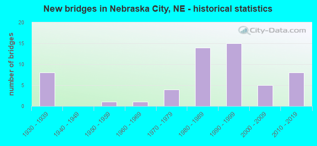
- New bridges - historical statistics
- 81930-1939
- 11950-1959
- 11960-1969
- 41970-1979
- 141980-1989
- 151990-1999
- 52000-2009
- 82010-2019
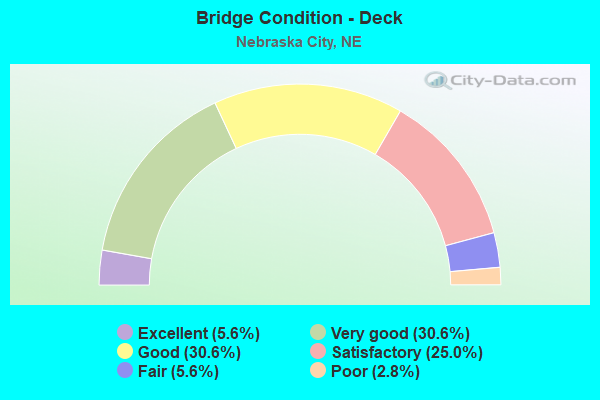
- Bridge Condition - Deck
- 5.6%Excellent
- 30.6%Very good
- 30.6%Good
- 25.0%Satisfactory
- 5.6%Fair
- 2.8%Poor
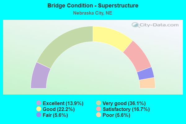
- Bridge Condition - Superstructure
- 13.9%Excellent
- 36.1%Very good
- 22.2%Good
- 16.7%Satisfactory
- 5.6%Fair
- 5.6%Poor
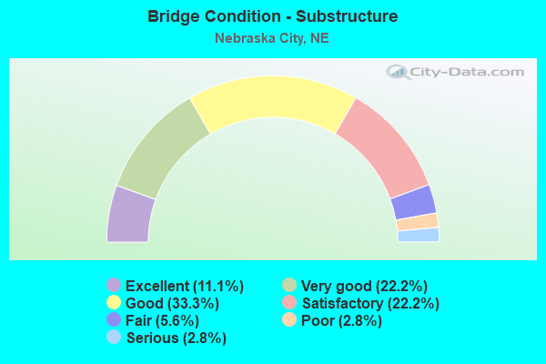
- Bridge Condition - Substructure
- 11.1%Excellent
- 22.2%Very good
- 33.3%Good
- 22.2%Satisfactory
- 5.6%Fair
- 2.8%Poor
- 2.8%Serious
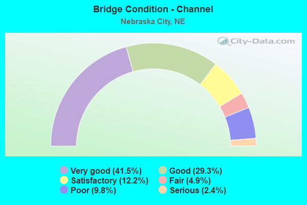
- Bridge Condition - Channel
- 41.5%Very good
- 29.3%Good
- 12.2%Satisfactory
- 4.9%Fair
- 9.8%Poor
- 2.4%Serious
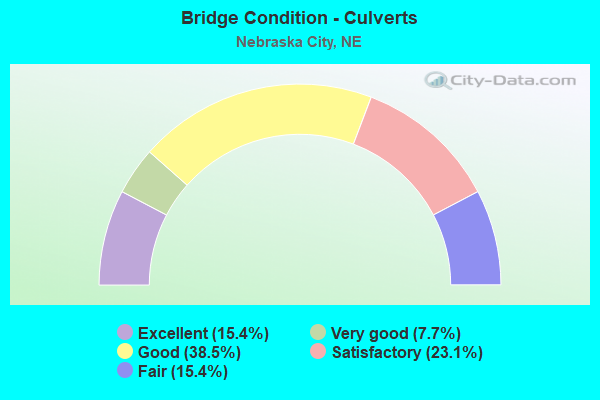
- Bridge Condition - Culverts
- 15.4%Excellent
- 7.7%Very good
- 38.5%Good
- 23.1%Satisfactory
- 15.4%Fair
Find on map >> Show street view
Structure Number: U1695E6505, Location: NEBR CITY 6TH ST @ 5TH (Lat: 40.681200, Lng: -95.852400), Route carried "on" structure: City street 6211, Year Built: 1965, Status: Open, Structure Length: 4.45m (14.60ft), Average Daily Traffic: 355 (year 2012), Average Future Daily Traffic: 355 (year 2033), Features Intersected: NORTH TABLE CREEK
Minimum Vertical Clearance: 30+ m (98+ ft), Kilometerpoint: 16.216, Lanes on structure: 2, Owner: City or Municipal Highway Agency, Approaching Roadway Width: 7.9m (25.9ft), Material/Design: Prestressed concrete, Design/Construction: Stringer/Multi-beam, Number Of Spans In Main Unit: 3, Length of Maximum Span: 17.1m (56.1ft), Curb or Sidewalk Widths: Left: 1.3m (4.3ft), Right: 0.1m (0.3ft), Curb-To-Curb Width: 7.3m (24.0ft), Out-to-Out Width: 9.5m (31.2ft)
Condition: Deck: Satisfactory, Superstructure: Good, Substructure: Satisfactory, Channel: Good, Operating Rating: 33.0 metric tons, Method Used To Determine Operating Rating: Field evaluation and documented engineering judgment, Inventory Rating: 22.0 metric tons, Method Used To Determine Inventory Rating: Field evaluation and documented engineering judgment, Structural Evaluation: Equal to present minimum criteria, Deck Geometry: Somewhat better than minimum adequacy, Waterway Adequacy: Better than present minimum criteria, Approach Roadway Alignment: Equal to present desirable criteria, Length Of Structure Improvement: 4.45m (14.60ft), Designated Inspection Frequency: Every 24 months, Inspection Date: December 2021, Deck Structure Type: Concrete Cast-file-Place, Wearing Surface/Protective System: Wearing Surface: Monolithic Concrete
Find on map >> Show street view
Structure Number: U1695H6305, Location: NEBR CITY 16TH @ FRONTAGE (Lat: 40.685400, Lng: -95.865200), Route carried "on" structure: City street 6205, Year Built: 1984, Status: Open, Structure Length: 3.78m (12.40ft), Average Daily Traffic: 1,340 (year 2012), Average Future Daily Traffic: 1,340 (year 2033), Features Intersected: NORTH TABLE CREEK
Minimum Vertical Clearance: 30+ m (98+ ft), Kilometerpoint: 16.230, Lanes on structure: 2, Owner: City or Municipal Highway Agency, Approaching Roadway Width: 9.1m (29.9ft), Skew: 3 degrees, Material/Design: Steel, Design/Construction: Stringer/Multi-beam, Number Of Spans In Main Unit: 1, Length of Maximum Span: 36.6m (120.1ft), Curb-To-Curb Width: 8.6m (28.2ft), Out-to-Out Width: 9.2m (30.2ft)
Condition: Deck: Satisfactory, Superstructure: Satisfactory, Substructure: Good, Channel: Very good, Operating Rating: 48.0 metric tons, Method Used To Determine Operating Rating: Load Factor (LF), Inventory Rating: 29.0 metric tons, Method Used To Determine Inventory Rating: Load Factor (LF), Structural Evaluation: Equal to present minimum criteria, Deck Geometry: Somewhat better than minimum adequacy, Waterway Adequacy: Better than present minimum criteria, Approach Roadway Alignment: Equal to present desirable criteria, Designated Inspection Frequency: Every 24 months, Inspection Date: December 2021, Deck Structure Type: Concrete Cast-file-Place, Wearing Surface/Protective System: Wearing Surface: Monolithic Concrete
Find on map >> Show street view
Structure Number: U1695H6505, Location: NEBR CITY 3RD ST @ 8TH (Lat: 40.669900, Lng: -95.848900), Route carried "on" structure: City street 6213, Year Built: 1978, Status: Open, Structure Length: 3.20m (10.50ft), Average Daily Traffic: 515 (year 2012), Average Future Daily Traffic: 515 (year 2033), Features Intersected: SOUTH TABLE CREEK
Minimum Vertical Clearance: 30+ m (98+ ft), Kilometerpoint: 16.270, Lanes on structure: 2, Owner: City or Municipal Highway Agency, Approaching Roadway Width: 7.6m (24.9ft), Skew: 1 degrees, Material/Design: Prestressed concrete, Design/Construction: Tee Beam, Number Of Spans In Main Unit: 3, Length of Maximum Span: 10.7m (35.1ft), Curb or Sidewalk Widths: Left: 1.2m (3.9ft), Right: 1.2m (3.9ft), Curb-To-Curb Width: 8.5m (27.9ft), Out-to-Out Width: 12.0m (39.4ft)
Condition: Deck: Poor, Superstructure: Satisfactory, Substructure: Fair, Channel: Satisfactory, Operating Rating: 33.0 metric tons, Method Used To Determine Operating Rating: Field evaluation and documented engineering judgment, Inventory Rating: 22.0 metric tons, Method Used To Determine Inventory Rating: Field evaluation and documented engineering judgment, Structural Evaluation: Somewhat better than minimum adequacy, Deck Geometry: Somewhat better than minimum adequacy, Waterway Adequacy: Equal to present minimum criteria, Approach Roadway Alignment: Equal to present desirable criteria, Designated Inspection Frequency: Every 24 months, Inspection Date: December 2021, Deck Structure Type: Concrete Cast-file-Place, Wearing Surface/Protective System: Wearing Surface: Monolithic Concrete
Find on map >> Show street view
Structure Number: U1695J1615, Location: NE CTY 4TH CORSO/3RRDST (Lat: 40.673500, Lng: -95.847800), Route carried "on" structure: City street 6217, Year Built: 2019, Status: Open, Structure Length: 17.37m (56.99ft), Average Daily Traffic: 4,130 (year 2017), Truck Traffic: 10%, Average Future Daily Traffic: 4,560 (year 2037), Design Load: HL 93, Features Intersected: UPRR/S TBL CR 432-930-B, Facility Carried by Structure: 4TH CORSO
Minimum Vertical Clearance: 30+ m (98+ ft), Kilometerpoint: 16.452, Lanes on structure: 2, Owner: City or Municipal Highway Agency, Approaching Roadway Width: 11.6m (38.1ft), Skew: 1 degrees, Material/Design: Prestressed concrete continuous, Design/Construction: Stringer/Multi-beam, Number Of Spans In Main Unit: 4, Length of Maximum Span: 50.3m (165.0ft), Curb or Sidewalk Widths: Left: 0.0m, Right: 3.0m (9.8ft), Curb-To-Curb Width: 11.6m (38.1ft), Out-to-Out Width: 15.4m (50.5ft)
Condition: Deck: Good, Superstructure: Very good, Substructure: Good, Channel: Good, Operating Rating: 45.0 metric tons, Method Used To Determine Operating Rating: Load and Resistance Factor (LRFR), Inventory Rating: 35.0 metric tons, Method Used To Determine Inventory Rating: Load and Resistance Factor (LRFR), Structural Evaluation: Better than present minimum criteria, Deck Geometry: Somewhat better than minimum adequacy, Underclear: Better than present minimum criteria, Waterway Adequacy: Superior to present desirable criteria, Approach Roadway Alignment: Equal to present desirable criteria, Length Of Structure Improvement: 23.04m (75.59ft), Designated Inspection Frequency: Every 24 months, Inspection Date: December 2020, Deck Structure Type: Concrete Cast-file-Place, Wearing Surface/Protective System: Wearing Surface: Monolithic Concrete, Deck Protection: Epoxy Coated Reinforcing
Find on map >> Show street view
Structure Number: U1695J6515, Location: NEBR CITY 1ST @ CENTRAL (Lat: 40.677000, Lng: -95.845000), Route carried "on" structure: City street J65, Year Built: 1983, Status: Open, Structure Length: 3.99m (13.09ft), Average Daily Traffic: 100 (year 2003), Truck Traffic: 10%, Average Future Daily Traffic: 135 (year 2033), Design Load: HS 20, Features Intersected: SOUTH TABLE CREEK, Facility Carried by Structure: 1ST STREET
Minimum Vertical Clearance: 30+ m (98+ ft), Kilometerpoint: 0.000, Lanes on structure: 2, Owner: City or Municipal Highway Agency, Approaching Roadway Width: 8.5m (27.9ft), Skew: 3 degrees, Material/Design: Concrete continuous, Design/Construction: Slab, Number Of Spans In Main Unit: 3, Length of Maximum Span: 15.8m (51.8ft), Curb-To-Curb Width: 8.5m (27.9ft), Out-to-Out Width: 9.2m (30.2ft)
Condition: Deck: Fair, Superstructure: Fair, Substructure: Satisfactory, Channel: Very good, Operating Rating: 53.0 metric tons, Method Used To Determine Operating Rating: Load Factor (LF), Inventory Rating: 32.0 metric tons, Method Used To Determine Inventory Rating: Load Factor (LF), Structural Evaluation: Somewhat better than minimum adequacy, Deck Geometry: Better than present minimum criteria, Waterway Adequacy: Equal to present desirable criteria, Approach Roadway Alignment: Equal to present desirable criteria, Designated Inspection Frequency: Every 24 months, Inspection Date: December 2020, Deck Structure Type: Concrete Cast-file-Place, Wearing Surface/Protective System: Wearing Surface: Monolithic Concrete
Find on map >> Show street view
Structure Number: U1695J652, Location: NEBR CITY 1ST ST@4TH AVE (Lat: 40.680000, Lng: -95.846700), Route carried "on" structure: City street J65, Year Built: 1985, Status: Open, Structure Length: 3.05m (10.01ft), Average Daily Traffic: 100 (year 2003), Truck Traffic: 10%, Average Future Daily Traffic: 135 (year 2033), Design Load: HS 20, Features Intersected: NORTH TABLE CREEK, Facility Carried by Structure: 1ST STREET
Minimum Vertical Clearance: 30+ m (98+ ft), Kilometerpoint: 0.000, Lanes on structure: 2, Owner: City or Municipal Highway Agency, Approaching Roadway Width: 7.3m (24.0ft), Material/Design: Concrete continuous, Design/Construction: Slab, Number Of Spans In Main Unit: 3, Length of Maximum Span: 12.2m (40.0ft), Curb-To-Curb Width: 9.1m (29.9ft), Out-to-Out Width: 9.8m (32.2ft)
Condition: Deck: Satisfactory, Superstructure: Satisfactory, Substructure: Good, Channel: Good, Operating Rating: 58.0 metric tons, Method Used To Determine Operating Rating: Load Factor (LF), Inventory Rating: 34.0 metric tons, Method Used To Determine Inventory Rating: Load Factor (LF), Structural Evaluation: Equal to present minimum criteria, Deck Geometry: Better than present minimum criteria, Waterway Adequacy: Equal to present desirable criteria, Approach Roadway Alignment: Equal to present minimum criteria, Designated Inspection Frequency: Every 24 months, Inspection Date: December 2020, Deck Structure Type: Concrete Cast-file-Place, Wearing Surface/Protective System: Wearing Surface: Monolithic Concrete
Find on map >> Show street view
Structure Number: U1695K6305, Location: NEBR CITY 13TH ST @ 6TH (Lat: 40.670000, Lng: -95.861700), Route carried "on" structure: City street K63, Year Built: 1992, Status: Open, Structure Length: 3.38m (11.09ft), Average Daily Traffic: 100 (year 2003), Truck Traffic: 10%, Average Future Daily Traffic: 135 (year 2033), Features Intersected: SOUTH TABLE CREEK, Facility Carried by Structure: 13TH STREET
Minimum Vertical Clearance: 30+ m (98+ ft), Kilometerpoint: 0.000, Lanes on structure: 2, Owner: City or Municipal Highway Agency, Approaching Roadway Width: 8.8m (28.9ft), Material/Design: Steel, Design/Construction: Stringer/Multi-beam, Number Of Spans In Main Unit: 1, Length of Maximum Span: 33.5m (109.9ft), Curb or Sidewalk Widths: Left: 1.8m (5.9ft), Right: 0.0m, Curb-To-Curb Width: 8.5m (27.9ft), Out-to-Out Width: 11.3m (37.1ft)
Condition: Deck: Good, Superstructure: Very good, Substructure: Good, Channel: Very good, Operating Rating: 86.0 metric tons, Method Used To Determine Operating Rating: Load Factor (LF), Inventory Rating: 52.0 metric tons, Method Used To Determine Inventory Rating: Load Factor (LF), Structural Evaluation: Better than present minimum criteria, Deck Geometry: Better than present minimum criteria, Waterway Adequacy: Equal to present desirable criteria, Approach Roadway Alignment: Equal to present desirable criteria, Designated Inspection Frequency: Every 24 months, Inspection Date: December 2021, Deck Structure Type: Concrete Cast-file-Place, Wearing Surface/Protective System: Wearing Surface: Monolithic Concrete, Deck Protection: Epoxy Coated Reinforcing
Find on map >> Show street view
Structure Number: S002 50361, Location: NEBRASKA CITY INTRCHG (Lat: 40.669500, Lng: -95.901400), Route carried "under" structure: State highway 2, Year Built: 1994, Structure Length: 0. m, Average Daily Traffic: 7,560 (year 2012), Truck Traffic: 28%, Features Intersected: N2
Minimum Vertical Clearance: 5.20m (17.06ft), Kilometerpoint: 81.048, Lanes on structure: 4, Lanes under structure: 4, Material/Design: Steel continuous, Design/Construction: Stringer/Multi-beam, Length of Maximum Span: 43.9m (144.0ft)
Find on map >> Show street view
Structure Number: S075 04868L, Location: NEBRASKA CITY INTRCHG (Lat: 40.665400, Lng: -95.895800), Route carried "under" structure: State highway 2, Year Built: 1994, Structure Length: 0. m, Average Daily Traffic: 6,750 (year 2000), Truck Traffic: 25%, Features Intersected: N2, Facility Carried by Structure: SB-US75 RMP N-S
Minimum Vertical Clearance: 5.89m (19.32ft), Kilometerpoint: 0.811, Lanes on structure: 4, Lanes under structure: 4, Material/Design: Steel continuous, Design/Construction: Stringer/Multi-beam, Length of Maximum Span: 45.1m (148.0ft)
Find on map >> Show street view
Structure Number: S075 04896, Location: NEBRASKA CITY INTRCHG (Lat: 40.669000, Lng: -95.897000), Route carried "under" structure: US 75, Year Built: 1994, Structure Length: 0. m, Average Daily Traffic: 3,055 (year 2012), Truck Traffic: 17%, Features Intersected: US75, Facility Carried by Structure: FAS 6217
Minimum Vertical Clearance: 5.00m (16.40ft), Kilometerpoint: 7.879, Lanes on structure: 4, Lanes under structure: 4, Material/Design: Prestressed concrete, Design/Construction: Stringer/Multi-beam, Length of Maximum Span: 36.3m (119.1ft)
Find on map >> Show street view
Structure Number: U1695B651, Location: NE CITY 9TH ST/9TH CORSO (Lat: 40.668100, Lng: -95.856000), Route carried "under" structure: City street 6209, Year Built: 1935, Structure Length: 0. m, Average Daily Traffic: 650 (year 2007), Features Intersected: UPRR, Facility Carried by Structure: UPRR
Minimum Vertical Clearance: 3.75m (12.30ft), Kilometerpoint: 16.113, Lanes under structure: 2, Material/Design: Steel, Design/Construction: Stringer/Multi-beam, Length of Maximum Span: 20.1m (65.9ft)
Find on map >> Show street view
Structure Number: U1695B6515, Location: NE CITY 9TH ST/9TH CORSO (Lat: 40.668400, Lng: -95.856000), Route carried "under" structure: City street 6209, Year Built: 1935, Structure Length: 0. m, Average Daily Traffic: 650 (year 2007), Features Intersected: BNSF RR 070-235-B, Facility Carried by Structure: BNSF RR
Minimum Vertical Clearance: 3.53m (11.58ft), Kilometerpoint: 16.116, Lanes under structure: 2, Material/Design: Steel, Design/Construction: Stringer/Multi-beam, Length of Maximum Span: 8.2m (26.9ft)
Find on map >> Show street view
Structure Number: U1695H651, Location: NE CITY 3RD ST/6TH CORSO (Lat: 40.671500, Lng: -95.848800), Route carried "under" structure: City street 6213, Year Built: 1935, Structure Length: 0. m, Average Daily Traffic: 590 (year 2007), Features Intersected: BNSF RR 070-236-H, Facility Carried by Structure: BNSF RR
Minimum Vertical Clearance: 5.61m (18.41ft), Kilometerpoint: 16.287, Lanes under structure: 2, Material/Design: Steel, Design/Construction: Girder and Floorbeam System, Length of Maximum Span: 15.8m (51.8ft)
Find on map >> Show street view
Structure Number: U1695J6505, Location: NEBR CITY 4TH TERR (Lat: 40.673300, Lng: -95.845000), Route carried "under" structure: City street J65, Year Built: 1935, Structure Length: 0. m, Average Daily Traffic: 1,010 (year 2003), Truck Traffic: 10%, Features Intersected: BNSF RR 070-237-P, Facility Carried by Structure: BNSF RR
Minimum Vertical Clearance: 3.96m (12.99ft), Kilometerpoint: 0.000, Lanes under structure: 2, Material/Design: Steel, Design/Construction: Stringer/Multi-beam, Length of Maximum Span: 15.5m (50.9ft)