Bridge Statistics for Naperville, Illinois (IL)
Condition, Traffic, Stress, Structural Evaluation, Project Costs
- National Bridge Inventory (NBI) Statistics
- 47Number of bridges
- 479ft / 146mTotal length
- $5,102,000Total costs
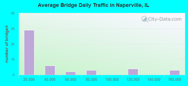
- 1,609,125Total average daily traffic
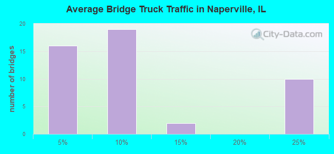
- 269,891Total average daily truck traffic
- National Bridge Inventory (NBI) Registered Bridges for Naperville
- No street view available for this location
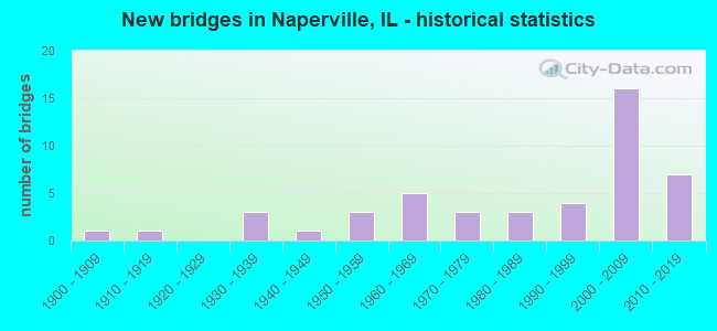
- New bridges - historical statistics
- 11900-1909
- 11910-1919
- 31930-1939
- 11940-1949
- 31950-1959
- 51960-1969
- 31970-1979
- 31980-1989
- 41990-1999
- 162000-2009
- 72010-2019
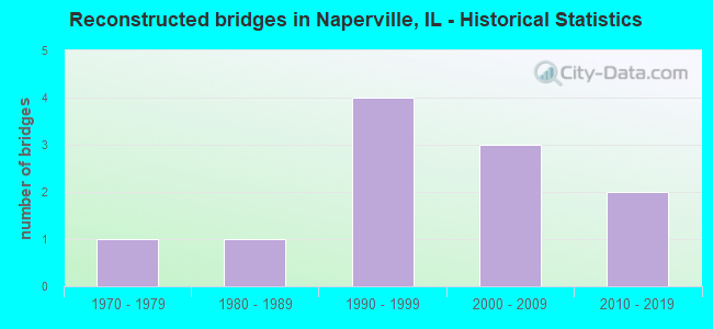
- Reconstructed bridges - Historical Statistics
- 11970-1979
- 11980-1989
- 41990-1999
- 32000-2009
- 22010-2019
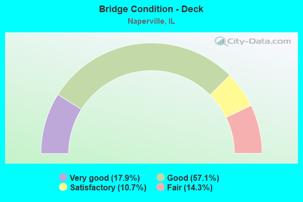
- Bridge Condition - Deck
- 17.9%Very good
- 57.1%Good
- 10.7%Satisfactory
- 14.3%Fair
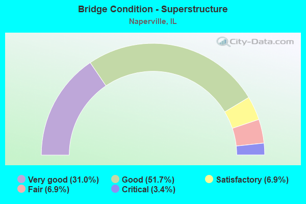
- Bridge Condition - Superstructure
- 31.0%Very good
- 51.7%Good
- 6.9%Satisfactory
- 6.9%Fair
- 3.4%Critical
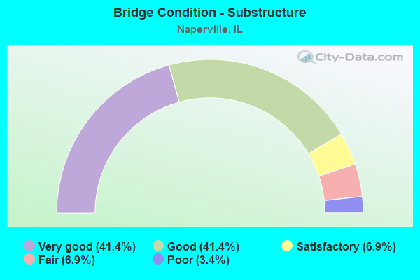
- Bridge Condition - Substructure
- 41.4%Very good
- 41.4%Good
- 6.9%Satisfactory
- 6.9%Fair
- 3.4%Poor
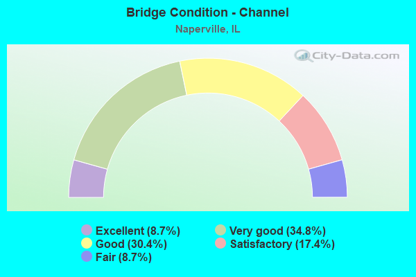
- Bridge Condition - Channel
- 8.7%Excellent
- 34.8%Very good
- 30.4%Good
- 17.4%Satisfactory
- 8.7%Fair
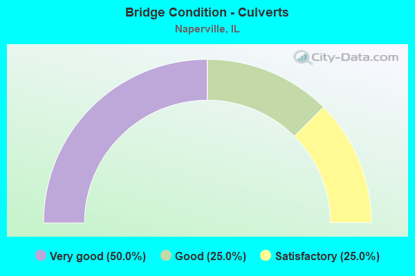
- Bridge Condition - Culverts
- 50.0%Very good
- 25.0%Good
- 25.0%Satisfactory
Find on map >> Show street view
Structure Number: 22003, Location: WASH. ST. 1M S US 34 (Lat: 41.770397, Lng: -88.148272), Route carried "on" structure: Other road , Year Built: 1976, Year Reconstructed: 1977, Status: Posted for load, Structure Length: 3.93m (12.89ft), Average Daily Traffic: 13,700 (year 2020), Truck Traffic: 3%, Average Future Daily Traffic: 28,073 (year 2032), Design Load: HS 20, Features Intersected: WEST BRANCH, Facility Carried by Structure: WASHINGTON ST
Minimum Vertical Clearance: 30+ m (98+ ft), Kilometerpoint: 4.538, Lanes on structure: 4, Base Highway Network: Yes, Owner: City or Municipal Highway Agency, Approaching Roadway Width: 13.4m (44.0ft), Skew: 2 degrees, Material/Design: Prestressed concrete, Design/Construction: Box Beam or Girders - Multiple, Number Of Spans In Main Unit: 3, Length of Maximum Span: 13.1m (43.0ft), Curb or Sidewalk Widths: Left: 2.4m (7.9ft), Right: 2.4m (7.9ft), Curb-To-Curb Width: 13.4m (44.0ft), Out-to-Out Width: 18.9m (62.0ft)
Condition: Deck: Satisfactory, Superstructure: Critical, Substructure: Satisfactory, Channel: Satisfactory, Operating Rating: 18.1 metric tons, Method Used To Determine Operating Rating: Load Factor (LF) rating reported by rating factor (RF) method using MS18 loading, Inventory Rating: 11.0 metric tons, Method Used To Determine Inventory Rating: Load Factor (LF) rating reported by rating factor (RF) method using MS18 loading, Structural Evaluation: High priority of replacement, Deck Geometry: High priority of replacement, Waterway Adequacy: Superior to present desirable criteria, Approach Roadway Alignment: Equal to present desirable criteria, Bridge Posting: Required (Relationship of Operating Rating to Maximum Legal Load: > 39.9% below), Length Of Structure Improvement: 4.72m (15.49ft), Designated Inspection Frequency: Every 24 months, Other Special Inspection Frequency: Every 1 months, Inspection Date: August 2020, Other Special Inspection Date: Febuary 2022, Bridge Improvement Cost: $681,000, Roadway Improvement Cost: $68,000, Total Project Cost: $1,022,000, Deck Structure Type: Concrete Precast Panels, Wearing Surface/Protective System: Wearing Surface: Latex Concrete, Deck Protection: Epoxy Coated Reinforcing
Find on map >> Show street view
Structure Number: 22004, Location: 5.3 M W OF IL 53 (Lat: 41.781881, Lng: -88.175339), Route carried "on" structure: US 34, Year Built: 1933, Year Reconstructed: 2008, Status: Open, Structure Length: 3.02m (9.91ft), Average Daily Traffic: 28,100 (year 2021), Truck Traffic: 5%, Average Future Daily Traffic: 35,314 (year 2032), Design Load: HS 20, Features Intersected: W BR DUPAGE RIVER
Minimum Vertical Clearance: 30+ m (98+ ft), Kilometerpoint: 308.358, Lanes on structure: 4, Base Highway Network: Yes, Owner: State Highway Agency, Approaching Roadway Width: 17.7m (58.1ft), Skew: 20 degrees, Material/Design: Prestressed concrete, Design/Construction: Box Beam or Girders - Multiple, Number Of Spans In Main Unit: 2, Length of Maximum Span: 14.2m (46.6ft), Curb or Sidewalk Widths: Left: 1.5m (4.9ft), Right: 1.5m (4.9ft), Curb-To-Curb Width: 17.7m (58.1ft), Out-to-Out Width: 21.3m (69.9ft)
Condition: Deck: Fair, Superstructure: Satisfactory, Substructure: Fair, Channel: Satisfactory, Operating Rating: 63.2 metric tons, Method Used To Determine Operating Rating: Load Factor (LF) rating reported by rating factor (RF) method using MS18 loading, Inventory Rating: 37.9 metric tons, Method Used To Determine Inventory Rating: Load Factor (LF) rating reported by rating factor (RF) method using MS18 loading, Structural Evaluation: Somewhat better than minimum adequacy, Deck Geometry: Somewhat better than minimum adequacy, Waterway Adequacy: Equal to present desirable criteria, Approach Roadway Alignment: Equal to present desirable criteria, Length Of Structure Improvement: 3.93m (12.89ft), Designated Inspection Frequency: Every 24 months, Inspection Date: October 2021, Bridge Improvement Cost: $1,069,000, Roadway Improvement Cost: $107,000, Total Project Cost: $1,604,000, Deck Structure Type: Concrete Cast-file-Place, Wearing Surface/Protective System: Wearing Surface: Integral Concrete, Deck Protection: Epoxy Coated Reinforcing
Find on map >> Show street view
Structure Number: 222029, Location: 1.2M S IL56 (Lat: 41.803919, Lng: -88.203836), Route carried "on" structure: State highway 59, Year Built: 2014, Status: Open, Structure Length: 7.71m (25.30ft), Average Daily Traffic: 34,300 (year 2021), Truck Traffic: 11%, Average Future Daily Traffic: 18,500 (year 2040), Design Load: HS 25 or greater, Features Intersected: I- 88 (TOLLWAY)
Minimum Vertical Clearance: 30+ m (98+ ft), Kilometerpoint: 33.087, Lanes on structure: 4, Lanes under structure: 12, Base Highway Network: Yes, Owner: State Highway Agency, Approaching Roadway Width: 7.3m (24.0ft), Material/Design: Prestressed concrete continuous, Design/Construction: Stringer/Multi-beam, Number Of Spans In Main Unit: 2, Length of Maximum Span: 38.1m (125.0ft), Curb or Sidewalk Widths: Left: 1.5m (4.9ft), Right: 0.0m, Curb-To-Curb Width: 14.0m (45.9ft), Out-to-Out Width: 16.3m (53.5ft)
Condition: Deck: Good, Superstructure: Very good, Substructure: Very good, Operating Rating: 59.0 metric tons, Method Used To Determine Operating Rating: Load and Resistance Factor Rating (LRFR) rating reported by rating factor(RF) method using HL-93 loadings, Inventory Rating: 45.4 metric tons, Method Used To Determine Inventory Rating: Load and Resistance Factor Rating (LRFR) rating reported by rating factor(RF) method using HL-93 loadings, Structural Evaluation: Equal to present desirable criteria, Deck Geometry: High priority of replacement, Approach Roadway Alignment: Equal to present desirable criteria, Designated Inspection Frequency: Every 24 months, Inspection Date: August 2019, Deck Structure Type: Concrete Cast-file-Place, Wearing Surface/Protective System: Deck Protection: Epoxy Coated Reinforcing
Find on map >> Show street view
Structure Number: 22203, Location: 1.2M S OF IL56 (Lat: 41.803589, Lng: -88.203847), Route carried "on" structure: State highway 59, Year Built: 2014, Status: Open, Structure Length: 7.71m (25.30ft), Average Daily Traffic: 48,400 (year 2021), Truck Traffic: 11%, Average Future Daily Traffic: 26,290 (year 2032), Design Load: HS 25 or greater, Features Intersected: I- 88 (TOLLWAY)
Minimum Vertical Clearance: 30+ m (98+ ft), Kilometerpoint: 33.055, Lanes on structure: 3, Lanes under structure: 6, Base Highway Network: Yes, Owner: State Highway Agency, Approaching Roadway Width: 14.0m (45.9ft), Material/Design: Prestressed concrete continuous, Design/Construction: Stringer/Multi-beam, Number Of Spans In Main Unit: 2, Length of Maximum Span: 38.1m (125.0ft), Curb or Sidewalk Widths: Left: 0.0m, Right: 3.0m (9.8ft), Curb-To-Curb Width: 14.0m (45.9ft), Out-to-Out Width: 18.2m (59.7ft)
Condition: Deck: Good, Superstructure: Good, Substructure: Very good, Operating Rating: 59.0 metric tons, Method Used To Determine Operating Rating: Load and Resistance Factor Rating (LRFR) rating reported by rating factor(RF) method using HL-93 loadings, Inventory Rating: 45.4 metric tons, Method Used To Determine Inventory Rating: Load and Resistance Factor Rating (LRFR) rating reported by rating factor(RF) method using HL-93 loadings, Structural Evaluation: Better than present minimum criteria, Deck Geometry: Somewhat better than minimum adequacy, Underclear: High priority of corrective action, Approach Roadway Alignment: Equal to present desirable criteria, Designated Inspection Frequency: Every 24 months, Inspection Date: August 2019, Deck Structure Type: Concrete Cast-file-Place, Wearing Surface/Protective System: Deck Protection: Epoxy Coated Reinforcing
Find on map >> Show street view
Structure Number: 223028, Location: N OF WILL CO E WASH (Lat: 41.740439, Lng: -88.126992), Route carried "on" structure: Other road , Year Built: 1969, Year Reconstructed: 2008, Status: Open, Structure Length: 3.29m (10.79ft), Average Daily Traffic: 4,450 (year 2020), Truck Traffic: 4%, Average Future Daily Traffic: 13,479 (year 2032), Design Load: HS 20, Features Intersected: WEST BR DUPAGE R, Facility Carried by Structure: BAILEY ROAD
Minimum Vertical Clearance: 30+ m (98+ ft), Kilometerpoint: 0.080, Lanes on structure: 2, Owner: City or Municipal Highway Agency, Approaching Roadway Width: 11.0m (36.1ft), Material/Design: Steel continuous, Design/Construction: Stringer/Multi-beam, Number Of Spans In Main Unit: 3, Length of Maximum Span: 10.7m (35.1ft), Curb or Sidewalk Widths: Left: 1.2m (3.9ft), Right: 1.2m (3.9ft), Curb-To-Curb Width: 11.0m (36.1ft), Out-to-Out Width: 17.3m (56.8ft)
Condition: Deck: Very good, Superstructure: Very good, Substructure: Very good, Channel: Very good, Operating Rating: 44.4 metric tons, Method Used To Determine Operating Rating: Load Factor (LF) rating reported by rating factor (RF) method using MS18 loading, Inventory Rating: 32.4 metric tons, Method Used To Determine Inventory Rating: Load Factor (LF) rating reported by rating factor (RF) method using MS18 loading, Structural Evaluation: Equal to present desirable criteria, Deck Geometry: Somewhat better than minimum adequacy, Waterway Adequacy: Equal to present desirable criteria, Approach Roadway Alignment: Equal to present desirable criteria, Length Of Structure Improvement: 3.20m (10.50ft), Designated Inspection Frequency: Every 48 months, Inspection Date: December 2018, Bridge Improvement Cost: $255,000, Roadway Improvement Cost: $26,000, Total Project Cost: $383,000, Deck Structure Type: Concrete Cast-file-Place, Wearing Surface/Protective System: Deck Protection: Epoxy Coated Reinforcing
Find on map >> Show street view
Structure Number: 223034, Location: COLUMBIA AVE OV RR (Lat: 41.779856, Lng: -88.137508), Route carried "on" structure: Other road , Year Built: 1975, Status: Open, Structure Length: 5.64m (18.50ft), Average Daily Traffic: 1,600 (year 2020), Truck Traffic: 6%, Average Future Daily Traffic: 2,841 (year 2032), Design Load: HS 20, Features Intersected: BN RR, Facility Carried by Structure: COLUMBIA AVENUE
Minimum Vertical Clearance: 30+ m (98+ ft), Kilometerpoint: 1.432, Lanes on structure: 2, Owner: City or Municipal Highway Agency, Approaching Roadway Width: 9.1m (29.9ft), Material/Design: Steel continuous, Design/Construction: Stringer/Multi-beam, Number Of Spans In Main Unit: 1, Length of Maximum Span: 56.4m (185.0ft), Curb or Sidewalk Widths: Left: 0.0m, Right: 2.4m (7.9ft), Curb-To-Curb Width: 10.7m (35.1ft), Out-to-Out Width: 14.7m (48.2ft)
Condition: Deck: Fair, Superstructure: Fair, Substructure: Satisfactory, Operating Rating: 44.4 metric tons, Method Used To Determine Operating Rating: Assigned rating based on Load Factor Design (LFD) reported by rating factor (RF) using MS18 loading, Inventory Rating: 32.4 metric tons, Method Used To Determine Inventory Rating: Assigned rating based on Load Factor Design (LFD) reported by rating factor (RF) using MS18 loading, Structural Evaluation: Somewhat better than minimum adequacy, Deck Geometry: Equal to present minimum criteria, Underclear: Superior to present desirable criteria, Approach Roadway Alignment: Equal to present desirable criteria, Designated Inspection Frequency: Every 24 months, Inspection Date: December 2021, Deck Structure Type: Concrete Cast-file-Place, Wearing Surface/Protective System: Wearing Surface: Bituminous, Membrane: Built-up
Find on map >> Show street view
Structure Number: 223051, Location: 0.1 MI E WASHNGTN BL (Lat: 41.750450, Lng: -88.130250), Route carried "on" structure: Other road , Year Built: 1998, Status: Open, Structure Length: 3.22m (10.56ft), Average Daily Traffic: 4,725 (year 2020), Truck Traffic: 3%, Average Future Daily Traffic: 8,188 (year 2032), Design Load: HS 20, Features Intersected: W BR DUPAGE RIVER, Facility Carried by Structure: HOBSON RD
Minimum Vertical Clearance: 30+ m (98+ ft), Kilometerpoint: 0.080, Lanes on structure: 2, Base Highway Network: Yes, Owner: County Highway Agency, Approaching Roadway Width: 14.6m (47.9ft), Material/Design: Prestressed concrete, Design/Construction: Box Beam or Girders - Multiple, Number Of Spans In Main Unit: 2, Length of Maximum Span: 15.8m (51.8ft), Curb or Sidewalk Widths: Left: 2.6m (8.5ft), Right: 3.1m (10.2ft), Curb-To-Curb Width: 14.8m (48.6ft), Out-to-Out Width: 21.8m (71.5ft)
Condition: Deck: Good, Superstructure: Good, Substructure: Very good, Channel: Good, Operating Rating: 59.0 metric tons, Method Used To Determine Operating Rating: Load Factor (LF) rating reported by rating factor (RF) method using MS18 loading, Inventory Rating: 35.3 metric tons, Method Used To Determine Inventory Rating: Load Factor (LF) rating reported by rating factor (RF) method using MS18 loading, Structural Evaluation: Better than present minimum criteria, Deck Geometry: Superior to present desirable criteria, Waterway Adequacy: Equal to present desirable criteria, Approach Roadway Alignment: Equal to present desirable criteria, Designated Inspection Frequency: Every 48 months, Inspection Date: October 2021, Deck Structure Type: Concrete Precast Panels
Find on map >> Show street view
Structure Number: 223107, Location: 0.3 MI E Raymond Dr (Lat: 41.803425, Lng: -88.186242), Route carried "on" structure: Other road , Year Built: 1992, Status: Open, Structure Length: 0.95m (3.12ft), Average Daily Traffic: 4,050 (year 2020), Truck Traffic: 5%, Average Future Daily Traffic: 10,583 (year 2032), Design Load: HS 20, Features Intersected: FERRY CREEK, Facility Carried by Structure: DIEHL ROAD
Minimum Vertical Clearance: 30+ m (98+ ft), Kilometerpoint: 4.699, Lanes on structure: 2, Base Highway Network: Yes, Owner: County Highway Agency, Approaching Roadway Width: 15.8m (51.8ft), Skew: 4 degrees, Material/Design: Concrete continuous, Design/Construction: Culvert, Number Of Spans In Main Unit: 2, Length of Maximum Span: 4.6m (15.1ft), Curb-To-Curb Width: 15.8m (51.8ft), Out-to-Out Width: 24.2m (79.4ft)
Condition: Channel: Fair, Culverts: Satisfactory, Operating Rating: 44.1 metric tons, Method Used To Determine Operating Rating: Assigned rating based on Load Factor Design (LFD) reported by rating factor (RF) using MS18 loading, Inventory Rating: 32.4 metric tons, Method Used To Determine Inventory Rating: Assigned rating based on Load Factor Design (LFD) reported by rating factor (RF) using MS18 loading, Structural Evaluation: Equal to present minimum criteria, Deck Geometry: Superior to present desirable criteria, Waterway Adequacy: Equal to present desirable criteria, Approach Roadway Alignment: Equal to present desirable criteria, Designated Inspection Frequency: Every 24 months, Inspection Date: October 2021
Find on map >> Show street view
Structure Number: 223118, Location: 0.1M E OF WASH ST (Lat: 41.748278, Lng: -88.129436), Route carried "on" structure: Other road , Year Built: 2010, Status: Open, Structure Length: 4.75m (15.58ft), Average Daily Traffic: 31,300 (year 2020), Truck Traffic: 7%, Average Future Daily Traffic: 56,100 (year 2037), Design Load: HS 20, Features Intersected: W. BR. DUPAGE RIVER, Facility Carried by Structure: 75TH ST
Minimum Vertical Clearance: 30+ m (98+ ft), Kilometerpoint: 7.966, Lanes on structure: 9, Base Highway Network: Yes, Owner: County Highway Agency, Approaching Roadway Width: 35.1m (115.2ft), Skew: 31 degrees, Material/Design: Steel continuous, Design/Construction: Stringer/Multi-beam, Number Of Spans In Main Unit: 3, Length of Maximum Span: 18.4m (60.4ft), Curb or Sidewalk Widths: Left: 2.0m (6.6ft), Right: 2.9m (9.5ft), Curb-To-Curb Width: 35.1m (115.2ft), Out-to-Out Width: 42.1m (138.1ft)
Condition: Deck: Fair, Superstructure: Good, Substructure: Good, Channel: Good, Operating Rating: 95.3 metric tons, Method Used To Determine Operating Rating: Load Factor (LF) rating reported by rating factor (RF) method using MS18 loading, Inventory Rating: 57.3 metric tons, Method Used To Determine Inventory Rating: Load Factor (LF) rating reported by rating factor (RF) method using MS18 loading, Structural Evaluation: Better than present minimum criteria, Deck Geometry: Somewhat better than minimum adequacy, Waterway Adequacy: Equal to present desirable criteria, Approach Roadway Alignment: Superior to present desirable criteria, Designated Inspection Frequency: Every 24 months, Inspection Date: April 2021, Deck Structure Type: Concrete Cast-file-Place, Wearing Surface/Protective System: Deck Protection: Epoxy Coated Reinforcing
Find on map >> Show street view
Structure Number: 22675, Location: 100 FT N EDGEWATER (Lat: 41.757922, Lng: -88.140019), Route carried "on" structure: Other road , Year Built: 1971, Year Reconstructed: 2002, Status: Open, Structure Length: 4.57m (14.99ft), Average Daily Traffic: 3,500 (year 2020), Truck Traffic: 4%, Average Future Daily Traffic: 9,135 (year 2032), Design Load: HS 20, Features Intersected: WEST BR DUPAGE RIVER, Facility Carried by Structure: GARTNER RD
Minimum Vertical Clearance: 30+ m (98+ ft), Kilometerpoint: 4.281, Lanes on structure: 2, Owner: City or Municipal Highway Agency, Approaching Roadway Width: 10.7m (35.1ft), Material/Design: Steel continuous, Design/Construction: Stringer/Multi-beam, Number Of Spans In Main Unit: 3, Length of Maximum Span: 15.2m (49.9ft), Curb or Sidewalk Widths: Left: 1.5m (4.9ft), Right: 4.9m (16.1ft), Curb-To-Curb Width: 10.8m (35.4ft), Out-to-Out Width: 13.0m (42.7ft)
Condition: Deck: Good, Superstructure: Very good, Substructure: Very good, Channel: Good, Operating Rating: 69.0 metric tons, Method Used To Determine Operating Rating: Load Factor (LF) rating reported by rating factor (RF) method using MS18 loading, Inventory Rating: 41.1 metric tons, Method Used To Determine Inventory Rating: Load Factor (LF) rating reported by rating factor (RF) method using MS18 loading, Structural Evaluation: Equal to present desirable criteria, Deck Geometry: Somewhat better than minimum adequacy, Waterway Adequacy: Superior to present desirable criteria, Approach Roadway Alignment: Equal to present desirable criteria, Length Of Structure Improvement: 4.57m (14.99ft), Designated Inspection Frequency: Every 48 months, Inspection Date: December 2018, Bridge Improvement Cost: $368,000, Roadway Improvement Cost: $37,000, Total Project Cost: $552,000, Deck Structure Type: Concrete Cast-file-Place, Wearing Surface/Protective System: Deck Protection: Epoxy Coated Reinforcing
Find on map >> Show street view
Structure Number: 226751, Location: EAGLE ST N OF AURORA (Lat: 41.771522, Lng: -88.152997), Route carried "on" structure: City street , Year Built: 1960, Year Reconstructed: 1995, Status: Open, Structure Length: 3.39m (11.12ft), Average Daily Traffic: 850 (year 2020), Truck Traffic: 5%, Average Future Daily Traffic: 567 (year 2032), Design Load: HS 20, Features Intersected: WEST BR.DUPAGE RIVER, Facility Carried by Structure: EAGLE ST.
Minimum Vertical Clearance: 30+ m (98+ ft), Kilometerpoint: 0.949, Lanes on structure: 2, Base Highway Network: Yes (Inventory Route: 2530B00, Subroute: 90), Owner: City or Municipal Highway Agency, Approaching Roadway Width: 15.2m (49.9ft), Material/Design: Concrete continuous, Design/Construction: Arch - Deck, Number Of Spans In Main Unit: 3, Number Of Approach Spans: 1, Length of Maximum Span: 11.9m (39.0ft), Curb or Sidewalk Widths: Left: 2.1m (6.9ft), Right: 2.1m (6.9ft), Curb-To-Curb Width: 10.7m (35.1ft), Out-to-Out Width: 15.2m (49.9ft)
Condition: Deck: Good, Superstructure: Good, Substructure: Fair, Channel: Very good, Operating Rating: 44.1 metric tons, Method Used To Determine Operating Rating: Load Factor (LF) rating reported by rating factor (RF) method using MS18 loading, Inventory Rating: 26.6 metric tons, Method Used To Determine Inventory Rating: Load Factor (LF) rating reported by rating factor (RF) method using MS18 loading, Structural Evaluation: Somewhat better than minimum adequacy, Deck Geometry: Equal to present minimum criteria, Waterway Adequacy: Equal to present desirable criteria, Approach Roadway Alignment: Equal to present desirable criteria, Designated Inspection Frequency: Every 24 months, Inspection Date: November 2021, Deck Structure Type: Other, Wearing Surface/Protective System: Deck Protection: Epoxy Coated Reinforcing
Find on map >> Show street view
Structure Number: 226753, Location: 150 FT W MELODY LA. (Lat: 41.766328, Lng: -88.157728), Route carried "on" structure: City street , Year Built: 1960, Year Reconstructed: 2001, Status: Open, Structure Length: 3.66m (12.01ft), Average Daily Traffic: 2,950 (year 2020), Truck Traffic: 7%, Average Future Daily Traffic: 567 (year 2032), Design Load: HS 20, Features Intersected: WEST BR DUPAGE R, Facility Carried by Structure: HILLSIDE RD
Minimum Vertical Clearance: 30+ m (98+ ft), Kilometerpoint: 0.080, Lanes on structure: 2, Owner: City or Municipal Highway Agency, Approaching Roadway Width: 9.4m (30.8ft), Skew: 1 degrees, Material/Design: Concrete continuous, Design/Construction: Slab, Number Of Spans In Main Unit: 3, Length of Maximum Span: 12.2m (40.0ft), Curb or Sidewalk Widths: Left: 2.4m (7.9ft), Right: 1.5m (4.9ft), Curb-To-Curb Width: 10.0m (32.8ft), Out-to-Out Width: 14.9m (48.9ft)
Condition: Deck: Very good, Superstructure: Very good, Substructure: Very good, Channel: Very good, Operating Rating: 54.1 metric tons, Method Used To Determine Operating Rating: Assigned rating based on Load Factor Design (LFD) reported by rating factor (RF) using MS18 loading, Inventory Rating: 32.4 metric tons, Method Used To Determine Inventory Rating: Assigned rating based on Load Factor Design (LFD) reported by rating factor (RF) using MS18 loading, Structural Evaluation: Equal to present desirable criteria, Deck Geometry: Meets minimum limits, Waterway Adequacy: Equal to present desirable criteria, Approach Roadway Alignment: Superior to present desirable criteria, Length Of Structure Improvement: 3.66m (12.01ft), Designated Inspection Frequency: Every 48 months, Inspection Date: August 2019, Bridge Improvement Cost: $299,000, Roadway Improvement Cost: $30,000, Total Project Cost: $449,000, Deck Structure Type: Concrete Cast-file-Place, Wearing Surface/Protective System: Deck Protection: Epoxy Coated Reinforcing
Find on map >> Show street view
Structure Number: 226755, Location: MAIN ST & CHICAGO AV (Lat: 41.770564, Lng: -88.149675), Route carried "on" structure: City street , Year Built: 2005, Status: Open, Structure Length: 3.56m (11.68ft), Average Daily Traffic: 5,900 (year 2020), Truck Traffic: 7%, Average Future Daily Traffic: 3,018 (year 2032), Design Load: HS 20, Features Intersected: DUPAGE RIVER, Facility Carried by Structure: MAIN ST
Minimum Vertical Clearance: 30+ m (98+ ft), Kilometerpoint: 0.644, Lanes on structure: 2, Owner: City or Municipal Highway Agency, Approaching Roadway Width: 11.6m (38.1ft), Skew: 3 degrees, Material/Design: Concrete continuous, Design/Construction: Slab, Number Of Spans In Main Unit: 2, Length of Maximum Span: 17.5m (57.4ft), Curb or Sidewalk Widths: Left: 2.4m (7.9ft), Right: 2.4m (7.9ft), Curb-To-Curb Width: 12.2m (40.0ft), Out-to-Out Width: 18.0m (59.1ft)
Condition: Deck: Good, Superstructure: Good, Substructure: Very good, Channel: Excellent, Operating Rating: 44.1 metric tons, Method Used To Determine Operating Rating: Assigned rating based on Load Factor Design (LFD) reported by rating factor (RF) using MS18 loading, Inventory Rating: 32.4 metric tons, Method Used To Determine Inventory Rating: Assigned rating based on Load Factor Design (LFD) reported by rating factor (RF) using MS18 loading, Structural Evaluation: Better than present minimum criteria, Deck Geometry: Somewhat better than minimum adequacy, Waterway Adequacy: Equal to present desirable criteria, Approach Roadway Alignment: Equal to present desirable criteria, Designated Inspection Frequency: Every 48 months, Inspection Date: September 2019, Deck Structure Type: Concrete Cast-file-Place, Wearing Surface/Protective System: Deck Protection: Epoxy Coated Reinforcing
Find on map >> Show street view
Structure Number: 226756, Location: .5M E OF RIVER RD (Lat: 41.772761, Lng: -88.166133), Route carried "on" structure: Other road , Year Built: 2010, Status: Open, Structure Length: 4.72m (15.49ft), Average Daily Traffic: 2,200 (year 2020), Truck Traffic: 7%, Average Future Daily Traffic: 13,368 (year 2032), Design Load: HS 20, Features Intersected: W. BR. DUPAGE RV, Facility Carried by Structure: JEFFERSON AV
Minimum Vertical Clearance: 30+ m (98+ ft), Kilometerpoint: 8.111, Lanes on structure: 2, Owner: City or Municipal Highway Agency, Approaching Roadway Width: 10.7m (35.1ft), Material/Design: Steel continuous, Design/Construction: Stringer/Multi-beam, Number Of Spans In Main Unit: 3, Length of Maximum Span: 19.1m (62.7ft), Curb or Sidewalk Widths: Left: 1.8m (5.9ft), Right: 1.8m (5.9ft), Curb-To-Curb Width: 10.7m (35.1ft), Out-to-Out Width: 15.9m (52.2ft)
Condition: Deck: Good, Superstructure: Very good, Substructure: Very good, Channel: Excellent, Operating Rating: 44.1 metric tons, Method Used To Determine Operating Rating: Assigned rating based on Load Factor Design (LFD) reported by rating factor (RF) using MS18 loading, Inventory Rating: 32.4 metric tons, Method Used To Determine Inventory Rating: Assigned rating based on Load Factor Design (LFD) reported by rating factor (RF) using MS18 loading, Structural Evaluation: Equal to present desirable criteria, Deck Geometry: Somewhat better than minimum adequacy, Waterway Adequacy: Superior to present desirable criteria, Approach Roadway Alignment: Equal to present desirable criteria, Designated Inspection Frequency: Every 48 months, Inspection Date: April 2021, Deck Structure Type: Concrete Cast-file-Place, Wearing Surface/Protective System: Deck Protection: Epoxy Coated Reinforcing
Find on map >> Show street view
Structure Number: 229019, Location: 0.06 MI E RAYMOND DR (Lat: 41.795986, Lng: -88.187453), Route carried "on" structure: Other road , Year Built: 2018, Status: Open, Structure Length: 4.08m (13.39ft), Average Daily Traffic: 400 (year 2020), Truck Traffic: 4%, Average Future Daily Traffic: 275 (year 2042), Design Load: HS 25 or greater, Features Intersected: W. BR. DUPAGE RIVER, Facility Carried by Structure: WEST ENTRANCE ROAD
Minimum Vertical Clearance: 30+ m (98+ ft), Kilometerpoint: 0.097, Lanes on structure: 1, Owner: Local Park, Forest, or Reservation Agency, Approaching Roadway Width: 8.2m (26.9ft), Material/Design: Prestressed concrete, Design/Construction: Stringer/Multi-beam, Number Of Spans In Main Unit: 1, Length of Maximum Span: 39.6m (129.9ft), Curb or Sidewalk Widths: Left: 3.0m (9.8ft), Right: 0.0m, Curb-To-Curb Width: 8.2m (26.9ft), Out-to-Out Width: 12.4m (40.7ft)
Condition: Deck: Very good, Superstructure: Very good, Substructure: Very good, Channel: Good, Operating Rating: 82.0 metric tons, Method Used To Determine Operating Rating: Load and Resistance Factor Rating (LRFR) rating reported by rating factor(RF) method using HL-93 loadings, Inventory Rating: 45.4 metric tons, Method Used To Determine Inventory Rating: Load and Resistance Factor Rating (LRFR) rating reported by rating factor(RF) method using HL-93 loadings, Structural Evaluation: Equal to present desirable criteria, Deck Geometry: Somewhat better than minimum adequacy, Waterway Adequacy: Equal to present desirable criteria, Approach Roadway Alignment: Equal to present desirable criteria, Designated Inspection Frequency: Every 24 months, Inspection Date: August 2020, Deck Structure Type: Concrete Cast-file-Place
Find on map >> Show street view
Structure Number: 229709, Location: 1M E ILL 59 (Lat: 41.804831, Lng: -88.188581), Route carried "on" structure: Other road , Year Built: 2000, Status: Open, Structure Length: 6.77m (22.21ft), Average Daily Traffic: 6,450 (year 2020), Truck Traffic: 7%, Average Future Daily Traffic: 14,593 (year 2032), Design Load: HS 20, Features Intersected: I-88 E-W TOLL RD., Facility Carried by Structure: RAYMOND DR
Minimum Vertical Clearance: 30+ m (98+ ft), Kilometerpoint: 0.161, Lanes on structure: 2, Lanes under structure: 4, Base Highway Network: Yes, Owner: County Highway Agency, Approaching Roadway Width: 9.1m (29.9ft), Material/Design: Prestressed concrete continuous, Design/Construction: Stringer/Multi-beam, Number Of Spans In Main Unit: 4, Length of Maximum Span: 20.4m (66.9ft), Curb-To-Curb Width: 7.3m (24.0ft), Out-to-Out Width: 9.1m (29.9ft)
Condition: Deck: Good, Superstructure: Good, Substructure: Good, Operating Rating: 81.6 metric tons, Method Used To Determine Operating Rating: Load Factor (LF) rating reported by rating factor (RF) method using MS18 loading, Inventory Rating: 48.9 metric tons, Method Used To Determine Inventory Rating: Load Factor (LF) rating reported by rating factor (RF) method using MS18 loading, Structural Evaluation: Better than present minimum criteria, Deck Geometry: High priority of replacement, Underclear: High priority of corrective action, Approach Roadway Alignment: Better than present minimum criteria, Designated Inspection Frequency: Every 24 months, Inspection Date: August 2019, Deck Structure Type: Concrete Cast-file-Place
Find on map >> Show street view
Structure Number: 229911, Location: 1M.W.OF N/VILLE RD. (Lat: 41.806250, Lng: -88.141431), Route carried "on" structure: Other road , Year Built: 1958, Status: Open, Structure Length: 7.20m (23.62ft), Average Daily Traffic: 7,550 (year 2020), Truck Traffic: 4%, Average Future Daily Traffic: 7,798 (year 2032), Design Load: HS 20+Mod, Features Intersected: FAI 88, Facility Carried by Structure: WASHINGTON ST
Minimum Vertical Clearance: 30+ m (98+ ft), Kilometerpoint: 0.354, Lanes on structure: 4, Lanes under structure: 6, Base Highway Network: Yes, Owner: City or Municipal Highway Agency, Approaching Roadway Width: 23.8m (78.1ft), Material/Design: Prestressed concrete continuous, Design/Construction: Stringer/Multi-beam, Number Of Spans In Main Unit: 2, Length of Maximum Span: 36.0m (118.1ft), Curb or Sidewalk Widths: Left: 1.8m (5.9ft), Right: 1.8m (5.9ft), Curb-To-Curb Width: 20.4m (66.9ft), Out-to-Out Width: 24.6m (80.7ft)
Condition: Deck: Good, Superstructure: Good, Substructure: Good, Operating Rating: 75.8 metric tons, Method Used To Determine Operating Rating: Load Factor (LF) rating reported by rating factor (RF) method using MS18 loading, Inventory Rating: 45.7 metric tons, Method Used To Determine Inventory Rating: Load Factor (LF) rating reported by rating factor (RF) method using MS18 loading, Structural Evaluation: Better than present minimum criteria, Deck Geometry: Superior to present desirable criteria, Underclear: Equal to present minimum criteria, Approach Roadway Alignment: Equal to present minimum criteria, Length Of Structure Improvement: 8.02m (26.31ft), Designated Inspection Frequency: Every 24 months, Inspection Date: August 2019, Bridge Improvement Cost: $578,000, Roadway Improvement Cost: $58,000, Total Project Cost: $867,000, Deck Structure Type: Concrete Cast-file-Place
Find on map >> Show street view
Structure Number: 22999, Location: 0.3 MI W OF NAPER RD (Lat: 41.805997, Lng: -88.125608), Route carried "on" structure: Interstate 88, Year Built: 2007, Status: Open, Structure Length: 5.95m (19.52ft), Average Daily Traffic: 73,400 (year 2019), Truck Traffic: 22%, Average Future Daily Traffic: 77,479 (year 2032), Design Load: HS 20, Features Intersected: FREEDOM DRIVE
Minimum Vertical Clearance: 30+ m (98+ ft), Kilometerpoint: 204.671, Lanes on structure: 4, Lanes under structure: 2, Base Highway Network: Yes, Toll: On toll road, Owner: State Toll Authority, Approaching Roadway Width: 22.6m (74.1ft), Skew: 2 degrees, Material/Design: Prestressed concrete, Design/Construction: Stringer/Multi-beam, Number Of Spans In Main Unit: 2, Number Of Approach Spans: 2, Length of Maximum Span: 31.5m (103.3ft), Curb-To-Curb Width: 22.6m (74.1ft), Out-to-Out Width: 23.6m (77.4ft)
Condition: Deck: Good, Superstructure: Good, Substructure: Good, Operating Rating: 62.9 metric tons, Method Used To Determine Operating Rating: Load Factor (LF) rating reported by rating factor (RF) method using MS18 loading, Inventory Rating: 37.6 metric tons, Method Used To Determine Inventory Rating: Load Factor (LF) rating reported by rating factor (RF) method using MS18 loading, Structural Evaluation: Better than present minimum criteria, Deck Geometry: Superior to present desirable criteria, Underclear: Meets minimum limits, Approach Roadway Alignment: Equal to present desirable criteria, Designated Inspection Frequency: Every 24 months, Inspection Date: September 2020, Deck Structure Type: Concrete Cast-file-Place, Wearing Surface/Protective System: Deck Protection: Epoxy Coated Reinforcing
Find on map >> Show street view
Structure Number: 229991, Location: 0.3MI W OF NAPER RD (Lat: 41.805992, Lng: -88.125333), Route carried "on" structure: Interstate 88, Year Built: 2008, Status: Open, Structure Length: 5.95m (19.52ft), Average Daily Traffic: 73,400 (year 2019), Truck Traffic: 22%, Average Future Daily Traffic: 301,300 (year 2035), Design Load: HS 20, Features Intersected: FREEDOM DRIVE
Minimum Vertical Clearance: 30+ m (98+ ft), Kilometerpoint: 204.687, Lanes on structure: 4, Lanes under structure: 3, Base Highway Network: Yes, Toll: On toll road, Owner: State Toll Authority, Approaching Roadway Width: 22.6m (74.1ft), Skew: 2 degrees, Material/Design: Prestressed concrete, Design/Construction: Stringer/Multi-beam, Number Of Spans In Main Unit: 2, Number Of Approach Spans: 2, Length of Maximum Span: 31.5m (103.3ft), Curb-To-Curb Width: 22.6m (74.1ft), Out-to-Out Width: 23.7m (77.8ft)
Condition: Deck: Good, Superstructure: Good, Substructure: Good, Operating Rating: 62.9 metric tons, Method Used To Determine Operating Rating: Load Factor (LF) rating reported by rating factor (RF) method using MS18 loading, Inventory Rating: 37.6 metric tons, Method Used To Determine Inventory Rating: Load Factor (LF) rating reported by rating factor (RF) method using MS18 loading, Structural Evaluation: Better than present minimum criteria, Deck Geometry: Superior to present desirable criteria, Underclear: Somewhat better than minimum adequacy, Approach Roadway Alignment: Equal to present desirable criteria, Designated Inspection Frequency: Every 24 months, Inspection Date: September 2020, Deck Structure Type: Concrete Cast-file-Place, Wearing Surface/Protective System: Deck Protection: Epoxy Coated Reinforcing
Find on map >> Show street view
Structure Number: 229992, Location: 0.1MI N OGDEN AVE (Lat: 41.805900, Lng: -88.119700), Route carried "on" structure: Interstate 88, Year Built: 2007, Status: Open, Structure Length: 5.92m (19.42ft), Average Daily Traffic: 73,400 (year 2019), Truck Traffic: 22%, Average Future Daily Traffic: 301,100 (year 2035), Design Load: HS 20, Features Intersected: NAPERVILLE/WHEAT RD
Minimum Vertical Clearance: 30+ m (98+ ft), Kilometerpoint: 205.154, Lanes on structure: 5, Lanes under structure: 4, Base Highway Network: Yes, Toll: On toll road, Owner: State Toll Authority, Approaching Roadway Width: 26.5m (86.9ft), Skew: 2 degrees, Material/Design: Steel, Design/Construction: Stringer/Multi-beam, Number Of Spans In Main Unit: 3, Number Of Approach Spans: 2, Length of Maximum Span: 31.4m (103.0ft), Curb-To-Curb Width: 26.5m (86.9ft), Out-to-Out Width: 27.4m (89.9ft)
Condition: Deck: Good, Superstructure: Satisfactory, Substructure: Good, Operating Rating: 71.6 metric tons, Method Used To Determine Operating Rating: Load Factor (LF) rating reported by rating factor (RF) method using MS18 loading, Inventory Rating: 42.8 metric tons, Method Used To Determine Inventory Rating: Load Factor (LF) rating reported by rating factor (RF) method using MS18 loading, Structural Evaluation: Equal to present minimum criteria, Deck Geometry: Superior to present desirable criteria, Underclear: High priority of corrective action, Approach Roadway Alignment: Equal to present desirable criteria, Designated Inspection Frequency: Every 24 months, Inspection Date: September 2020, Deck Structure Type: Concrete Cast-file-Place, Wearing Surface/Protective System: Deck Protection: Epoxy Coated Reinforcing
Find on map >> Show street view
Structure Number: 229993, Location: 0.1MI N OGDEN AVE (Lat: 41.805894, Lng: -88.119508), Route carried "on" structure: Interstate 88, Year Built: 2008, Status: Open, Structure Length: 5.92m (19.42ft), Average Daily Traffic: 146,800 (year 2019), Truck Traffic: 22%, Average Future Daily Traffic: 301,100 (year 2035), Design Load: HS 20, Features Intersected: NAPERVILLE/WHEAT RD
Minimum Vertical Clearance: 30+ m (98+ ft), Kilometerpoint: 205.170, Lanes on structure: 6, Lanes under structure: 4, Base Highway Network: Yes, Toll: On toll road, Owner: State Toll Authority, Approaching Roadway Width: 30.9m (101.4ft), Skew: 2 degrees, Material/Design: Steel, Design/Construction: Stringer/Multi-beam, Number Of Spans In Main Unit: 3, Number Of Approach Spans: 2, Length of Maximum Span: 31.4m (103.0ft), Curb-To-Curb Width: 30.9m (101.4ft), Out-to-Out Width: 31.8m (104.3ft)
Condition: Deck: Good, Superstructure: Good, Substructure: Good, Operating Rating: 67.7 metric tons, Method Used To Determine Operating Rating: Load Factor (LF) rating reported by rating factor (RF) method using MS18 loading, Inventory Rating: 40.5 metric tons, Method Used To Determine Inventory Rating: Load Factor (LF) rating reported by rating factor (RF) method using MS18 loading, Structural Evaluation: Better than present minimum criteria, Deck Geometry: Superior to present desirable criteria, Underclear: High priority of corrective action, Approach Roadway Alignment: Equal to present desirable criteria, Designated Inspection Frequency: Every 24 months, Inspection Date: September 2020, Deck Structure Type: Concrete Cast-file-Place, Wearing Surface/Protective System: Deck Protection: Epoxy Coated Reinforcing
Find on map >> Show street view
Structure Number: 229995, Location: 2.3 MI E IL59 (Lat: 41.806489, Lng: -88.157047), Route carried "on" structure: Other road , Year Built: 2005, Status: Open, Structure Length: 7.22m (23.69ft), Average Daily Traffic: 6,000 (year 2020), Truck Traffic: 4%, Average Future Daily Traffic: 10,400 (year 2035), Design Load: HS 20, Features Intersected: I-88 REAGAN TOLLWAY, Facility Carried by Structure: MILL ST
Minimum Vertical Clearance: 30+ m (98+ ft), Kilometerpoint: 0.708, Lanes on structure: 4, Lanes under structure: 8, Base Highway Network: Yes, Owner: County Highway Agency, Approaching Roadway Width: 14.6m (47.9ft), Material/Design: Steel, Design/Construction: Stringer/Multi-beam, Number Of Spans In Main Unit: 2, Length of Maximum Span: 35.7m (117.1ft), Curb or Sidewalk Widths: Left: 1.5m (4.9ft), Right: 1.5m (4.9ft), Curb-To-Curb Width: 15.5m (50.9ft), Out-to-Out Width: 20.1m (65.9ft)
Condition: Deck: Good, Superstructure: Good, Substructure: Good, Operating Rating: 84.9 metric tons, Method Used To Determine Operating Rating: Load Factor (LF) rating reported by rating factor (RF) method using MS18 loading, Inventory Rating: 50.9 metric tons, Method Used To Determine Inventory Rating: Load Factor (LF) rating reported by rating factor (RF) method using MS18 loading, Structural Evaluation: Better than present minimum criteria, Deck Geometry: Meets minimum limits, Underclear: Somewhat better than minimum adequacy, Approach Roadway Alignment: Equal to present desirable criteria, Designated Inspection Frequency: Every 24 months, Inspection Date: September 2020, Deck Structure Type: Concrete Cast-file-Place, Wearing Surface/Protective System: Deck Protection: Epoxy Coated Reinforcing
Find on map >> Show street view
Structure Number: 993105, Location: 0.1 MI WPL./NAPERVIL (Lat: 41.710328, Lng: -88.169008), Route carried "on" structure: Other road , Year Built: 1964, Year Reconstructed: 2017, Status: Open, Structure Length: 1.56m (5.12ft), Average Daily Traffic: 16,900 (year 2019), Truck Traffic: 4%, Average Future Daily Traffic: 15,200 (year 2032), Design Load: HS 20, Features Intersected: SPRINGBROOK, Facility Carried by Structure: 95TH ST
Minimum Vertical Clearance: 30+ m (98+ ft), Kilometerpoint: 4.683, Lanes on structure: 4, Base Highway Network: Yes, Owner: City or Municipal Highway Agency, Approaching Roadway Width: 19.5m (64.0ft), Skew: 32 degrees, Material/Design: Concrete continuous, Design/Construction: Slab, Number Of Spans In Main Unit: 2, Number Of Approach Spans: 2, Length of Maximum Span: 7.9m (25.9ft), Curb or Sidewalk Widths: Left: 0.0m, Right: 1.7m (5.6ft), Curb-To-Curb Width: 19.5m (64.0ft), Out-to-Out Width: 25.4m (83.3ft)
Condition: Deck: Very good, Superstructure: Very good, Substructure: Very good, Channel: Very good, Operating Rating: 69.3 metric tons, Method Used To Determine Operating Rating: Load Factor (LF) rating reported by rating factor (RF) method using MS18 loading, Inventory Rating: 41.5 metric tons, Method Used To Determine Inventory Rating: Load Factor (LF) rating reported by rating factor (RF) method using MS18 loading, Structural Evaluation: Equal to present desirable criteria, Deck Geometry: Better than present minimum criteria, Waterway Adequacy: Superior to present desirable criteria, Approach Roadway Alignment: Equal to present desirable criteria, Designated Inspection Frequency: Every 48 months, Inspection Date: March 2020, Deck Structure Type: Concrete Cast-file-Place, Wearing Surface/Protective System: Wearing Surface: Other
Find on map >> Show street view
Structure Number: 993322, Location: 0.2 MI S ROYCE RD. (Lat: 41.711031, Lng: -88.127994), Route carried "on" structure: Other road , Year Built: 1982, Year Reconstructed: 2011, Status: Open, Structure Length: 3.29m (10.79ft), Average Daily Traffic: 28,700 (year 2019), Truck Traffic: 6%, Average Future Daily Traffic: 20,987 (year 2032), Design Load: HS 20, Features Intersected: E BR DUPAGE RIVER, Facility Carried by Structure: WEBER ROAD
Minimum Vertical Clearance: 30+ m (98+ ft), Kilometerpoint: 2.414, Lanes on structure: 2, Base Highway Network: Yes, Owner: City or Municipal Highway Agency, Approaching Roadway Width: 14.6m (47.9ft), Material/Design: Prestressed concrete, Design/Construction: Box Beam or Girders - Multiple, Number Of Spans In Main Unit: 3, Length of Maximum Span: 13.4m (44.0ft), Curb-To-Curb Width: 17.1m (56.1ft), Out-to-Out Width: 17.1m (56.1ft)
Condition: Deck: Satisfactory, Superstructure: Very good, Substructure: Good, Channel: Good, Operating Rating: 53.8 metric tons, Method Used To Determine Operating Rating: Load Factor (LF) rating reported by rating factor (RF) method using MS18 loading, Inventory Rating: 32.4 metric tons, Method Used To Determine Inventory Rating: Load Factor (LF) rating reported by rating factor (RF) method using MS18 loading, Structural Evaluation: Better than present minimum criteria, Deck Geometry: Superior to present desirable criteria, Waterway Adequacy: Better than present minimum criteria, Approach Roadway Alignment: Better than present minimum criteria, Designated Inspection Frequency: Every 48 months, Inspection Date: June 2019, Deck Structure Type: Concrete Precast Panels, Wearing Surface/Protective System: Wearing Surface: Integral Concrete, Deck Protection: Epoxy Coated Reinforcing
Find on map >> Show street view
Structure Number: 993326, Location: .4 MI S DUPAGE CO (Lat: 41.720592, Lng: -88.132286), Route carried "on" structure: Other road , Year Built: 1984, Year Reconstructed: 2016, Status: Open, Structure Length: 3.32m (10.89ft), Average Daily Traffic: 18,100 (year 2019), Truck Traffic: 4%, Average Future Daily Traffic: 25,000 (year 2040), Design Load: HS 20, Features Intersected: W.BR.DUPAGE RIVER, Facility Carried by Structure: WASHINGTON ST.
Minimum Vertical Clearance: 30+ m (98+ ft), Kilometerpoint: 0.724, Lanes on structure: 4, Base Highway Network: Yes, Owner: City or Municipal Highway Agency, Approaching Roadway Width: 14.3m (46.9ft), Skew: 3 degrees, Material/Design: Prestressed concrete, Design/Construction: Box Beam or Girders - Multiple, Number Of Spans In Main Unit: 2, Length of Maximum Span: 16.5m (54.1ft), Curb or Sidewalk Widths: Left: 1.5m (4.9ft), Right: 1.5m (4.9ft), Curb-To-Curb Width: 17.1m (56.1ft), Out-to-Out Width: 21.9m (71.9ft)
Condition: Deck: Good, Superstructure: Good, Substructure: Very good, Channel: Very good, Operating Rating: 44.4 metric tons, Method Used To Determine Operating Rating: Assigned rating based on Load Factor Design (LFD) reported by rating factor (RF) using MS18 loading, Inventory Rating: 32.4 metric tons, Method Used To Determine Inventory Rating: Assigned rating based on Load Factor Design (LFD) reported by rating factor (RF) using MS18 loading, Structural Evaluation: Better than present minimum criteria, Deck Geometry: Somewhat better than minimum adequacy, Waterway Adequacy: Equal to present desirable criteria, Approach Roadway Alignment: Equal to present desirable criteria, Designated Inspection Frequency: Every 48 months, Inspection Date: October 2019, Deck Structure Type: Concrete Precast Panels, Wearing Surface/Protective System: Wearing Surface: Integral Concrete, Deck Protection: Epoxy Coated Reinforcing
Find on map >> Show street view
Structure Number: 993335, Location: 0.2 MI N 95TH ST (Lat: 41.713450, Lng: -88.167144), Route carried "on" structure: Other road , Year Built: 1993, Status: Open, Structure Length: 1.96m (6.43ft), Average Daily Traffic: 11,450 (year 2019), Truck Traffic: 3%, Average Future Daily Traffic: 11,063 (year 2032), Design Load: HS 20, Features Intersected: SPRING BROOK, Facility Carried by Structure: NAP-PLFD RD
Minimum Vertical Clearance: 30+ m (98+ ft), Kilometerpoint: 1.304, Lanes on structure: 2, Base Highway Network: Yes, Owner: County Highway Agency, Approaching Roadway Width: 24.4m (80.1ft), Skew: 5 degrees, Material/Design: Concrete continuous, Design/Construction: Culvert, Number Of Spans In Main Unit: 3, Length of Maximum Span: 6.1m (20.0ft)
Condition: Channel: Satisfactory, Culverts: Very good, Operating Rating: 44.1 metric tons, Method Used To Determine Operating Rating: Assigned rating based on Load Factor Design (LFD) reported by rating factor (RF) using MS18 loading, Inventory Rating: 32.4 metric tons, Method Used To Determine Inventory Rating: Assigned rating based on Load Factor Design (LFD) reported by rating factor (RF) using MS18 loading, Structural Evaluation: Equal to present desirable criteria, Waterway Adequacy: Equal to present desirable criteria, Approach Roadway Alignment: Equal to present desirable criteria, Designated Inspection Frequency: Every 48 months, Inspection Date: March 2020
Find on map >> Show street view
Structure Number: 993336, Location: 0.1MI S 95TH STREET (Lat: 41.707444, Lng: -88.166950), Route carried "on" structure: Other road , Year Built: 1940, Year Reconstructed: 1992, Status: Open, Structure Length: 1.16m (3.81ft), Average Daily Traffic: 8,500 (year 2019), Truck Traffic: 4%, Average Future Daily Traffic: 9,990 (year 2032), Design Load: HS 20, Features Intersected: SPRING BROOK CREEK, Facility Carried by Structure: PLAINFIELD-NAPERVI
Minimum Vertical Clearance: 30+ m (98+ ft), Kilometerpoint: 1.963, Lanes on structure: 2, Base Highway Network: Yes, Owner: County Highway Agency, Approaching Roadway Width: 9.1m (29.9ft), Material/Design: Concrete continuous, Design/Construction: Culvert, Number Of Spans In Main Unit: 3, Number Of Approach Spans: 19, Length of Maximum Span: 3.7m (12.1ft)
Condition: Channel: Satisfactory, Culverts: Very good, Operating Rating: 82.0 metric tons, Method Used To Determine Operating Rating: Load Factor (LF) rating reported by rating factor (RF) method using MS18 loading, Inventory Rating: 48.9 metric tons, Method Used To Determine Inventory Rating: Load Factor (LF) rating reported by rating factor (RF) method using MS18 loading, Structural Evaluation: Equal to present desirable criteria, Waterway Adequacy: Equal to present desirable criteria, Approach Roadway Alignment: Equal to present desirable criteria, Designated Inspection Frequency: Every 24 months, Inspection Date: May 2021
Find on map >> Show street view
Structure Number: 993383, Location: .8M W OF PLNFELD RD (Lat: 41.680797, Lng: -88.182267), Route carried "on" structure: Other road , Year Built: 2002, Status: Open, Structure Length: 9.19m (30.15ft), Average Daily Traffic: 18,900 (year 2019), Truck Traffic: 5%, Average Future Daily Traffic: 22,600 (year 2032), Design Load: HS 20, Features Intersected: DUPAGE RIVER, Facility Carried by Structure: 111TH ST
Minimum Vertical Clearance: 30+ m (98+ ft), Kilometerpoint: 6.518, Lanes on structure: 4, Base Highway Network: Yes, Owner: County Highway Agency, Approaching Roadway Width: 20.1m (65.9ft), Skew: 5 degrees, Material/Design: Prestressed concrete continuous, Design/Construction: Stringer/Multi-beam, Number Of Spans In Main Unit: 3, Length of Maximum Span: 30.8m (101.0ft), Curb-To-Curb Width: 20.1m (65.9ft), Out-to-Out Width: 25.0m (82.0ft)
Condition: Deck: Satisfactory, Superstructure: Good, Substructure: Good, Channel: Very good, Operating Rating: 44.1 metric tons, Method Used To Determine Operating Rating: Assigned rating based on Load Factor Design (LFD) reported by rating factor (RF) using MS18 loading, Inventory Rating: 32.4 metric tons, Method Used To Determine Inventory Rating: Assigned rating based on Load Factor Design (LFD) reported by rating factor (RF) using MS18 loading, Structural Evaluation: Better than present minimum criteria, Deck Geometry: Better than present minimum criteria, Waterway Adequacy: Equal to present desirable criteria, Approach Roadway Alignment: Equal to present desirable criteria, Designated Inspection Frequency: Every 24 months, Inspection Date: July 2020, Deck Structure Type: Concrete Cast-file-Place, Wearing Surface/Protective System: Deck Protection: Epoxy Coated Reinforcing
Find on map >> Show street view
Structure Number: 993384, Location: 0.6M N OF 111TH ST (Lat: 41.690400, Lng: -88.166350), Route carried "on" structure: Other road , Year Built: 2003, Year Reconstructed: 2004, Status: Open, Structure Length: 6.62m (21.72ft), Average Daily Traffic: 17,000 (year 2019), Truck Traffic: 4%, Average Future Daily Traffic: 19,981 (year 2032), Design Load: H 20, Features Intersected: DUPAGE RIVER, Facility Carried by Structure: PLAINFIEL_NAPERVIL
Minimum Vertical Clearance: 30+ m (98+ ft), Kilometerpoint: 3.895, Lanes on structure: 4, Base Highway Network: Yes, Owner: County Highway Agency, Approaching Roadway Width: 20.7m (67.9ft), Skew: 2 degrees, Material/Design: Prestressed concrete continuous, Design/Construction: Stringer/Multi-beam, Number Of Spans In Main Unit: 3, Length of Maximum Span: 21.3m (69.9ft), Curb-To-Curb Width: 20.7m (67.9ft), Out-to-Out Width: 25.0m (82.0ft)
Condition: Deck: Good, Superstructure: Good, Substructure: Good, Channel: Very good, Operating Rating: 60.3 metric tons, Method Used To Determine Operating Rating: Load Factor (LF) rating reported by rating factor (RF) method using MS18 loading, Inventory Rating: 36.0 metric tons, Method Used To Determine Inventory Rating: Load Factor (LF) rating reported by rating factor (RF) method using MS18 loading, Structural Evaluation: Better than present minimum criteria, Deck Geometry: Superior to present desirable criteria, Waterway Adequacy: Equal to present desirable criteria, Approach Roadway Alignment: Equal to present desirable criteria, Designated Inspection Frequency: Every 48 months, Inspection Date: July 2020, Deck Structure Type: Concrete Cast-file-Place, Wearing Surface/Protective System: Deck Protection: Epoxy Coated Reinforcing
Find on map >> Show street view
Structure Number: 993399, Location: 0.2 M.E.PLAIN-NAP RD (Lat: 41.725864, Lng: -88.163189), Route carried "on" structure: Other road , Year Built: 1961, Status: Open, Structure Length: 1.58m (5.18ft), Average Daily Traffic: 8,350 (year 2019), Truck Traffic: 6%, Average Future Daily Traffic: 11,130 (year 2032), Design Load: H 20, Features Intersected: SPRING BROOK CR, Facility Carried by Structure: 87TH STREET
Minimum Vertical Clearance: 30+ m (98+ ft), Kilometerpoint: 3.492, Lanes on structure: 2, Owner: City or Municipal Highway Agency, Approaching Roadway Width: 7.3m (24.0ft), Material/Design: Prestressed concrete, Design/Construction: Box Beam or Girders - Multiple, Number Of Spans In Main Unit: 2, Length of Maximum Span: 7.3m (24.0ft), Curb-To-Curb Width: 7.6m (24.9ft), Out-to-Out Width: 8.3m (27.2ft)
Condition: Deck: Fair, Superstructure: Fair, Substructure: Poor, Channel: Fair, Operating Rating: 77.1 metric tons, Method Used To Determine Operating Rating: Load Factor (LF) rating reported by rating factor (RF) method using MS18 loading, Inventory Rating: 46.3 metric tons, Method Used To Determine Inventory Rating: Load Factor (LF) rating reported by rating factor (RF) method using MS18 loading, Structural Evaluation: Meets minimum limits, Deck Geometry: High priority of replacement, Waterway Adequacy: Equal to present minimum criteria, Approach Roadway Alignment: Equal to present desirable criteria, Length Of Structure Improvement: 2.23m (7.32ft), Designated Inspection Frequency: Every 24 months, Inspection Date: November 2021, Bridge Improvement Cost: $150,000, Roadway Improvement Cost: $15,000, Total Project Cost: $225,000, Deck Structure Type: Concrete Precast Panels, Wearing Surface/Protective System: Wearing Surface: Bituminous, Membrane: Built-up
Find on map >> Show street view
Structure Number: 994001, Location: 1.1 MI E IL 59 (Lat: 41.666450, Lng: -88.183061), Route carried "on" structure: Other road , Year Built: 1983, Status: Open, Structure Length: 6.31m (20.70ft), Average Daily Traffic: 9,550 (year 2019), Truck Traffic: 6%, Average Future Daily Traffic: 11,667 (year 2032), Design Load: HS 20, Features Intersected: DUPAGE RIVER, Facility Carried by Structure: 119 TH STREET
Minimum Vertical Clearance: 30+ m (98+ ft), Kilometerpoint: 4.747, Lanes on structure: 2, Base Highway Network: Yes, Owner: Town or Township Highway Agency, Approaching Roadway Width: 7.9m (25.9ft), Skew: 1 degrees, Material/Design: Steel continuous, Design/Construction: Stringer/Multi-beam, Number Of Spans In Main Unit: 3, Length of Maximum Span: 24.1m (79.1ft), Curb-To-Curb Width: 9.1m (29.9ft), Out-to-Out Width: 10.1m (33.1ft)
Condition: Deck: Very good, Superstructure: Very good, Substructure: Very good, Channel: Good, Operating Rating: 44.4 metric tons, Method Used To Determine Operating Rating: Assigned rating based on Load Factor Design (LFD) reported by rating factor (RF) using MS18 loading, Inventory Rating: 32.4 metric tons, Method Used To Determine Inventory Rating: Assigned rating based on Load Factor Design (LFD) reported by rating factor (RF) using MS18 loading, Structural Evaluation: Equal to present desirable criteria, Deck Geometry: Meets minimum limits, Waterway Adequacy: Equal to present desirable criteria, Approach Roadway Alignment: Equal to present desirable criteria, Designated Inspection Frequency: Every 48 months, Inspection Date: March 2020, Deck Structure Type: Concrete Cast-file-Place
Find on map >> Show street view
Structure Number: 994618, Location: 0.28 M N OF 111TH ST (Lat: 41.684147, Lng: -88.204889), Route carried "on" structure: State highway 59, Year Built: 2001, Status: Open, Structure Length: 0.75m (2.46ft), Average Daily Traffic: 34,500 (year 2021), Truck Traffic: 6%, Average Future Daily Traffic: 27,692 (year 2032), Design Load: HS 20, Features Intersected: CLOW CREEK
Minimum Vertical Clearance: 30+ m (98+ ft), Kilometerpoint: 19.746, Lanes on structure: 2, Base Highway Network: Yes, Owner: State Highway Agency, Approaching Roadway Width: 14.6m (47.9ft), Skew: 1 degrees, Material/Design: Concrete continuous, Design/Construction: Culvert, Number Of Spans In Main Unit: 3, Length of Maximum Span: 3.3m (10.8ft)
Condition: Channel: Good, Culverts: Good, Operating Rating: 96.2 metric tons, Method Used To Determine Operating Rating: Load Factor (LF) rating reported by rating factor (RF) method using MS18 loading, Inventory Rating: 57.7 metric tons, Method Used To Determine Inventory Rating: Load Factor (LF) rating reported by rating factor (RF) method using MS18 loading, Structural Evaluation: Better than present minimum criteria, Waterway Adequacy: Equal to present desirable criteria, Approach Roadway Alignment: Equal to present desirable criteria, Designated Inspection Frequency: Every 48 months, Inspection Date: May 2018
Find on map >> Show street view
Structure Number: 996755, Location: 5 MI NNE OFPLAINFIEL (Lat: 41.686619, Lng: -88.185592), Route carried "on" structure: County highway , Year Built: 1995, Status: Open, Structure Length: 0.79m (2.59ft), Average Daily Traffic: 6,750 (year 2019), Truck Traffic: 4%, Average Future Daily Traffic: 11,935 (year 2032), Design Load: HS 20, Features Intersected: CLOW CREEK, Facility Carried by Structure: BOOK ROAD
Minimum Vertical Clearance: 30+ m (98+ ft), Kilometerpoint: 0.772, Lanes on structure: 2, Owner: City or Municipal Highway Agency, Approaching Roadway Width: 17.8m (58.4ft), Skew: 1 degrees, Material/Design: Concrete, Design/Construction: Frame, Number Of Spans In Main Unit: 1, Length of Maximum Span: 7.5m (24.6ft), Curb or Sidewalk Widths: Left: 2.1m (6.9ft), Right: 2.1m (6.9ft), Curb-To-Curb Width: 17.7m (58.1ft), Out-to-Out Width: 23.0m (75.5ft)
Condition: Superstructure: Good, Substructure: Good, Channel: Very good, Operating Rating: 44.1 metric tons, Method Used To Determine Operating Rating: Assigned rating based on Load Factor Design (LFD) reported by rating factor (RF) using MS18 loading, Inventory Rating: 32.4 metric tons, Method Used To Determine Inventory Rating: Assigned rating based on Load Factor Design (LFD) reported by rating factor (RF) using MS18 loading, Structural Evaluation: Better than present minimum criteria, Deck Geometry: Superior to present desirable criteria, Waterway Adequacy: Equal to present desirable criteria, Approach Roadway Alignment: Equal to present desirable criteria, Designated Inspection Frequency: Every 48 months, Inspection Date: August 2019, Wearing Surface/Protective System: Wearing Surface: Bituminous, Membrane: Built-up
Find on map >> Show street view
Structure Number: 220031, Location: 0.5 M S US 34 (Lat: 41.779597, Lng: -88.147572), Route carried "under" structure: Other road , Year Built: 1900, Structure Length: 0. m, Average Daily Traffic: 13,700 (year 2020), Truck Traffic: 3%, Features Intersected: WASHINGTON ST, Facility Carried by Structure: CB&Q RR (BN RR)
Minimum Vertical Clearance: 4.34m (14.24ft), Kilometerpoint: 3.540, Lanes under structure: 4, Material/Design: Concrete, Design/Construction: Slab, Length of Maximum Span: 20.1m (65.9ft)
Find on map >> Show street view
Structure Number: 220038, Location: 2.0 M S I-88 EW TOLL (Lat: 41.778236, Lng: -88.205706), Route carried "under" structure: State highway 59, Year Built: 1935, Structure Length: 0. m, Average Daily Traffic: 50,700 (year 2021), Truck Traffic: 5%, Features Intersected: IL 59, Facility Carried by Structure: RR - BNSF
Minimum Vertical Clearance: 4.62m (15.16ft), Kilometerpoint: 30.174, Lanes under structure: 4, Material/Design: Steel, Design/Construction: Stringer/Multi-beam, Length of Maximum Span: 14.6m (47.9ft)
Find on map >> Show street view
Structure Number: 220039, Location: NAPERVILLE (Lat: 41.778831, Lng: -88.184739), Route carried "under" structure: US 34, Year Built: 1934, Structure Length: 0. m, Average Daily Traffic: 31,300 (year 2021), Truck Traffic: 5%, Features Intersected: US 34, Facility Carried by Structure: BURLINGTON N RR
Minimum Vertical Clearance: 4.45m (14.60ft), Kilometerpoint: 307.489, Lanes under structure: 4, Material/Design: Steel, Design/Construction: Girder and Floorbeam System, Length of Maximum Span: 13.7m (44.9ft)
Find on map >> Show street view
Structure Number: 222029, Location: 1.2M S IL56 (Lat: 41.803600, Lng: -88.203694), Route carried "under" structure: Interstate 88, Year Built: 2014, Structure Length: 0. m, Average Daily Traffic: 109,100 (year 2020), Truck Traffic: 22%, Features Intersected: I- 88 (TOLLWAY), Facility Carried by Structure: IL 59 NB
Minimum Vertical Clearance: 5.05m (16.57ft), Kilometerpoint: 198.137, Lanes on structure: 4, Lanes under structure: 12, Material/Design: Prestressed concrete continuous, Design/Construction: Stringer/Multi-beam, Length of Maximum Span: 38.1m (125.0ft)
Find on map >> Show street view
Structure Number: 22203, Location: 1.2M S OF IL56 (Lat: 41.803589, Lng: -88.203847), Route carried "under" structure: Interstate 88, Year Built: 2014, Structure Length: 0. m, Average Daily Traffic: 102,100 (year 2020), Truck Traffic: 22%, Features Intersected: I- 88 (TOLLWAY), Facility Carried by Structure: IL 59 SB
Minimum Vertical Clearance: 5.05m (16.57ft), Kilometerpoint: 198.121, Lanes on structure: 3, Lanes under structure: 6, Material/Design: Prestressed concrete continuous, Design/Construction: Stringer/Multi-beam, Length of Maximum Span: 38.1m (125.0ft)
Find on map >> Show street view
Structure Number: 229709, Location: 1M E ILL 59 (Lat: 41.804831, Lng: -88.188581), Route carried "under" structure: Interstate 88, Year Built: 2000, Structure Length: 0. m, Average Daily Traffic: 109,100 (year 2020), Truck Traffic: 22%, Features Intersected: I-88 E-W TOLL RD., Facility Carried by Structure: RAYMOND DR
Minimum Vertical Clearance: 30+ m (98+ ft), Kilometerpoint: 199.392, Lanes on structure: 2, Lanes under structure: 4, Material/Design: Prestressed concrete continuous, Design/Construction: Stringer/Multi-beam, Length of Maximum Span: 20.4m (66.9ft)
Find on map >> Show street view
Structure Number: 229911, Location: 1M.W.OF N/VILLE RD. (Lat: 41.806250, Lng: -88.141431), Route carried "under" structure: Interstate 88, Year Built: 1958, Structure Length: 0. m, Average Daily Traffic: 146,800 (year 2019), Truck Traffic: 22%, Features Intersected: FAI 88, Facility Carried by Structure: WASHINGTON ST
Minimum Vertical Clearance: 4.98m (16.34ft), Kilometerpoint: 203.335, Lanes on structure: 4, Lanes under structure: 6, Material/Design: Prestressed concrete continuous, Design/Construction: Stringer/Multi-beam, Length of Maximum Span: 36.0m (118.1ft)
Find on map >> Show street view
Structure Number: 229913, Location: 1.5 M E KANE CO LINE (Lat: 41.801475, Lng: -88.230069), Route carried "under" structure: Interstate 88, Year Built: 1958, Structure Length: 0. m, Average Daily Traffic: 102,100 (year 2020), Truck Traffic: 22%, Features Intersected: I-88 E-W TOLL RD., Facility Carried by Structure: E.J.&E. RR
Minimum Vertical Clearance: 4.70m (15.42ft), Kilometerpoint: 195.916, Lanes under structure: 4, Material/Design: Steel, Design/Construction: Girder and Floorbeam System, Length of Maximum Span: 20.1m (65.9ft)
Find on map >> Show street view
Structure Number: 22995, Location: 1.3 M E OF ILL 59 (Lat: 41.781489, Lng: -88.231689), Route carried "under" structure: Other road , Year Built: 1912, Structure Length: 0. m, Average Daily Traffic: 12,700 (year 2020), Truck Traffic: 9%, Features Intersected: NORTH AURORA ROAD, Facility Carried by Structure: E.J.&E. R.R.
Minimum Vertical Clearance: 3.56m (11.68ft), Kilometerpoint: 2.575, Lanes under structure: 2, Material/Design: Steel, Length of Maximum Span: 12.5m (41.0ft)
Find on map >> Show street view
Structure Number: 22999, Location: 0.3 MI W OF NAPER RD (Lat: 41.805986, Lng: -88.125058), Route carried "under" structure: Other road , Year Built: 2007, Structure Length: 0. m, Average Daily Traffic: 3,600 (year 2020), Truck Traffic: 6%, Features Intersected: FREEDOM DRIVE, Facility Carried by Structure: I88 EB RON REAGAN
Minimum Vertical Clearance: 4.98m (16.34ft), Kilometerpoint: 0.370, Lanes on structure: 4, Lanes under structure: 2, Toll: On toll road, Material/Design: Prestressed concrete, Design/Construction: Stringer/Multi-beam, Length of Maximum Span: 31.5m (103.3ft)