Bridge Statistics for Missoula, Montana (MT)
Condition, Traffic, Stress, Structural Evaluation, Project Costs
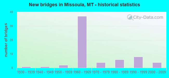
- New bridges - historical statistics
- 11930-1939
- 11940-1949
- 21950-1959
- 371960-1969
- 41970-1979
- 61980-1989
- 81990-1999
- 42000-2009
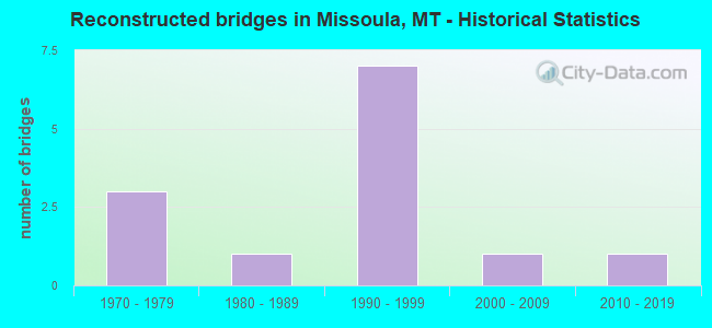
- Reconstructed bridges - Historical Statistics
- 31970-1979
- 11980-1989
- 71990-1999
- 12000-2009
- 12010-2019
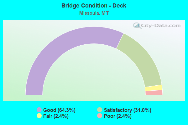
- Bridge Condition - Deck
- 64.3%Good
- 31.0%Satisfactory
- 2.4%Fair
- 2.4%Poor

- Bridge Condition - Superstructure
- 2.4%Very good
- 57.1%Good
- 16.7%Satisfactory
- 16.7%Fair
- 4.8%Poor
- 2.4%Serious
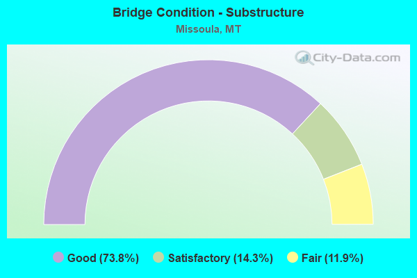
- Bridge Condition - Substructure
- 73.8%Good
- 14.3%Satisfactory
- 11.9%Fair
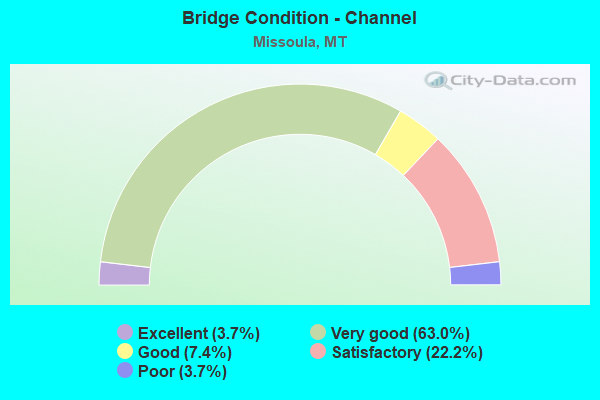
- Bridge Condition - Channel
- 3.7%Excellent
- 63.0%Very good
- 7.4%Good
- 22.2%Satisfactory
- 3.7%Poor
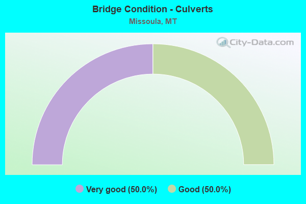
- Bridge Condition - Culverts
- 50.0%Very good
- 50.0%Good
Find on map >> Show street view
Structure Number: U08107001+04101, Location: MISSOULA-S ORANGE ST (Lat: 46.870283, Lng: -114.002864), Route carried "on" structure: City street 130, Year Built: 2002, Status: Open, Structure Length: 0.68m (2.23ft), Average Daily Traffic: 19,329 (year 2020), Average Future Daily Traffic: 20,295 (year 2040), Design Load: HL 93, Features Intersected: PEDESTRIAN-BIKE PATH, Facility Carried by Structure: S ORANGE ST
Minimum Vertical Clearance: 30+ m (98+ ft), Kilometerpoint: 2.324, Lanes on structure: 4, Owner: State Highway Agency, Approaching Roadway Width: 28.8m (94.5ft), Material/Design: Steel, Design/Construction: Culvert, Number Of Spans In Main Unit: 1, Length of Maximum Span: 6.8m (22.3ft)
Condition: Culverts: Very good, Operating Rating: 47.2 metric tons, Method Used To Determine Operating Rating: Load and Resistance Factor (LRFR), Inventory Rating: 36.3 metric tons, Method Used To Determine Inventory Rating: Load and Resistance Factor (LRFR), Structural Evaluation: Equal to present desirable criteria, Approach Roadway Alignment: Better than present minimum criteria, Designated Inspection Frequency: Every 24 months, Inspection Date: June 2020
Find on map >> Show street view
Structure Number: U08107001+05401, Location: MISSOULA-S ORANGE ST (Lat: 46.871550, Lng: -114.000681), Route carried "on" structure: City street 130, Year Built: 2003, Status: Open, Structure Length: 15.14m (49.67ft), Average Daily Traffic: 19,329 (year 2020), Average Future Daily Traffic: 20,295 (year 2040), Design Load: HS 20, Features Intersected: CLARK FORK RIVER, Facility Carried by Structure: S ORANGE ST
Minimum Vertical Clearance: 30+ m (98+ ft), Kilometerpoint: 2.541, Lanes on structure: 4, Owner: State Highway Agency, Approaching Roadway Width: 18.0m (59.1ft), Material/Design: Prestressed concrete continuous, Design/Construction: Stringer/Multi-beam, Number Of Spans In Main Unit: 4, Length of Maximum Span: 50.0m (164.0ft), Curb or Sidewalk Widths: Left: 2.0m (6.6ft), Right: 2.0m (6.6ft), Curb-To-Curb Width: 18.0m (59.1ft), Out-to-Out Width: 23.8m (78.1ft)
Condition: Deck: Good, Superstructure: Satisfactory, Substructure: Good, Channel: Very good, Operating Rating: 29.0 metric tons, Method Used To Determine Operating Rating: Load and Resistance Factor (LRFR), Inventory Rating: 20.0 metric tons, Method Used To Determine Inventory Rating: Load and Resistance Factor (LRFR), Structural Evaluation: Somewhat better than minimum adequacy, Deck Geometry: Somewhat better than minimum adequacy, Waterway Adequacy: Superior to present desirable criteria, Approach Roadway Alignment: Equal to present desirable criteria, Designated Inspection Frequency: Every 24 months, Inspection Date: July 2020, Deck Structure Type: Concrete Cast-file-Place, Wearing Surface/Protective System: Wearing Surface: Monolithic Concrete, Deck Protection: Epoxy Coated Reinforcing
Find on map >> Show street view
Structure Number: U08109000+04771, Location: MISSOULA-SCOTT ST (Lat: 46.883003, Lng: -114.006253), Route carried "on" structure: City street 8109, Year Built: 1979, Year Reconstructed: 2009, Status: Open, Structure Length: 31.22m (102.43ft), Average Daily Traffic: 7,764 (year 2020), Truck Traffic: 1%, Average Future Daily Traffic: 9,123 (year 2040), Design Load: HS 20, Features Intersected: RR, Facility Carried by Structure: SCOTT ST
Minimum Vertical Clearance: 30+ m (98+ ft), Kilometerpoint: 0.781, Lanes on structure: 2, Owner: City or Municipal Highway Agency, Approaching Roadway Width: 11.0m (36.1ft), Skew: 2 degrees, Material/Design: Steel continuous, Design/Construction: Stringer/Multi-beam, Number Of Spans In Main Unit: 2, Number Of Approach Spans: 10, Length of Maximum Span: 51.2m (168.0ft), Curb or Sidewalk Widths: Left: 0.0m, Right: 2.2m (7.2ft), Curb-To-Curb Width: 11.0m (36.1ft), Out-to-Out Width: 13.6m (44.6ft)
Condition: Deck: Satisfactory, Superstructure: Good, Substructure: Satisfactory, Operating Rating: 40.8 metric tons, Method Used To Determine Operating Rating: Load and Resistance Factor (LRFR), Inventory Rating: 30.8 metric tons, Method Used To Determine Inventory Rating: Load and Resistance Factor (LRFR), Structural Evaluation: Equal to present minimum criteria, Deck Geometry: Meets minimum limits, Underclear: High priority of corrective action, Approach Roadway Alignment: Better than present minimum criteria, Designated Inspection Frequency: Every 24 months, Inspection Date: September 2021, Deck Structure Type: Concrete Cast-file-Place, Wearing Surface/Protective System: Wearing Surface: Monolithic Concrete, Deck Protection: Epoxy Coated Reinforcing
Find on map >> Show street view
Structure Number: U08110000+05751, Location: MISSOULA-E FRONT ST (Lat: 46.868483, Lng: -113.985203), Route carried "on" structure: City street 8134, Year Built: 1932, Status: Open, Structure Length: 1.62m (5.31ft), Average Daily Traffic: 1,471 (year 2020), Truck Traffic: 1%, Average Future Daily Traffic: 1,545 (year 2040), Features Intersected: RATTLESNAKE CREEK, Facility Carried by Structure: E FRONT ST
Minimum Vertical Clearance: 30+ m (98+ ft), Kilometerpoint: 0.166, Lanes on structure: 2, Owner: City or Municipal Highway Agency, Approaching Roadway Width: 9.1m (29.9ft), Material/Design: Concrete, Design/Construction: Tee Beam, Number Of Spans In Main Unit: 1, Length of Maximum Span: 16.2m (53.1ft), Curb or Sidewalk Widths: Left: 1.5m (4.9ft), Right: 1.5m (4.9ft), Curb-To-Curb Width: 9.1m (29.9ft), Out-to-Out Width: 13.1m (43.0ft)
Condition: Deck: Good, Superstructure: Good, Substructure: Satisfactory, Channel: Very good, Operating Rating: 40.8 metric tons, Method Used To Determine Operating Rating: Field evaluation and documented engineering judgment, Inventory Rating: 24.5 metric tons, Method Used To Determine Inventory Rating: Field evaluation and documented engineering judgment, Structural Evaluation: Equal to present minimum criteria, Deck Geometry: Somewhat better than minimum adequacy, Waterway Adequacy: Equal to present desirable criteria, Approach Roadway Alignment: Equal to present desirable criteria, Designated Inspection Frequency: Every 24 months, Inspection Date: June 2020
Find on map >> Show street view
Structure Number: U08113000+02381, Location: MISSOULA-S HIGGINS AVE (Lat: 46.868244, Lng: -113.996436), Route carried "on" structure: City street 8113, Year Built: 1962, Year Reconstructed: 1981, Status: Posted for load, Structure Length: 29.62m (97.18ft), Average Daily Traffic: 14,463 (year 2020), Average Future Daily Traffic: 15,186 (year 2040), Design Load: HS 20, Features Intersected: CLARK FORK R-PED PATHS, Facility Carried by Structure: S HIGGINS AVE
Minimum Vertical Clearance: 30+ m (98+ ft), Kilometerpoint: 0.340, Lanes on structure: 4, Lanes under structure: 2, Owner: State Highway Agency, Approaching Roadway Width: 16.8m (55.1ft), Skew: 20 degrees, Material/Design: Steel continuous, Design/Construction: Girder and Floorbeam System, Number Of Spans In Main Unit: 3, Number Of Approach Spans: 10, Length of Maximum Span: 52.4m (171.9ft), Curb or Sidewalk Widths: Left: 1.5m (4.9ft), Right: 1.5m (4.9ft), Curb-To-Curb Width: 17.1m (56.1ft), Out-to-Out Width: 20.2m (66.3ft)
Condition: Deck: Poor, Superstructure: Serious, Substructure: Fair, Channel: Satisfactory, Operating Rating: 34.5 metric tons, Method Used To Determine Operating Rating: Load Factor (LF), Inventory Rating: 20.9 metric tons, Method Used To Determine Inventory Rating: Load Factor (LF), Structural Evaluation: High priority of corrective action, Deck Geometry: Somewhat better than minimum adequacy, Underclear: Somewhat better than minimum adequacy, Waterway Adequacy: Superior to present desirable criteria, Approach Roadway Alignment: Equal to present desirable criteria, Bridge Posting: Required (Relationship of Operating Rating to Maximum Legal Load: 30.0 - 39.9% below), Length Of Structure Improvement: 29.59m (97.08ft), Designated Inspection Frequency: Every 24 months, Critical Feature Inspection Frequency: Every 24 months, Underwater Inspection Frequency: Every 60 months, Inspection Date: June 2020, Critical Feature Inspection Date: June 2020, Underwater Inspection Date: October 2018, Bridge Improvement Cost: $3,828,000, Roadway Improvement Cost: $1,914,000, Total Project Cost: $5,742,000, Deck Structure Type: Concrete Cast-file-Place, Wearing Surface/Protective System: Wearing Surface: Latex Concrete
Find on map >> Show street view
Structure Number: I00090099+09351, Location: AIRPORT INTERCHANGE (Lat: 46.923211, Lng: -114.068314), Route carried "under" structure: County highway 32791, Year Built: 1997, Structure Length: 0. m, Average Daily Traffic: 9,311 (year 2020), Truck Traffic: 3%, Features Intersected: SEP AIRWAY BLVD, Facility Carried by Structure: I 90
Minimum Vertical Clearance: 5.51m (18.08ft), Kilometerpoint: 0.905, Lanes on structure: 2, Lanes under structure: 2, Material/Design: Prestressed concrete, Design/Construction: Stringer/Multi-beam, Length of Maximum Span: 22.6m (74.1ft)
Find on map >> Show street view
Structure Number: I00090099+09352, Location: AIRPORT INTERCHANGE (Lat: 46.923442, Lng: -114.068064), Route carried "under" structure: County highway 32791, Year Built: 1997, Structure Length: 0. m, Average Daily Traffic: 9,311 (year 2020), Truck Traffic: 3%, Features Intersected: SEP AIRWAY BLVD, Facility Carried by Structure: I 90
Minimum Vertical Clearance: 5.51m (18.08ft), Kilometerpoint: 0.873, Lanes on structure: 2, Lanes under structure: 2, Material/Design: Prestressed concrete, Design/Construction: Stringer/Multi-beam, Length of Maximum Span: 22.6m (74.1ft)
Find on map >> Show street view
Structure Number: I00090101+07081, Location: MISSOULA (Lat: 46.913022, Lng: -114.034361), Route carried "under" structure: US 93, Year Built: 1966, Structure Length: 0. m, Average Daily Traffic: 5,495 (year 2020), Truck Traffic: 12%, Features Intersected: INT RESERVE STREET, Facility Carried by Structure: I 90
Minimum Vertical Clearance: 5.36m (17.59ft), Kilometerpoint: 0.002, Lanes on structure: 2, Lanes under structure: 2, Material/Design: Prestressed concrete, Design/Construction: Stringer/Multi-beam, Length of Maximum Span: 15.8m (51.8ft)
Find on map >> Show street view
Structure Number: I00090101+07082, Location: MISSOULA (Lat: 46.913325, Lng: -114.034231), Route carried "under" structure: US 93, Year Built: 1966, Structure Length: 0. m, Average Daily Traffic: 5,495 (year 2020), Truck Traffic: 12%, Features Intersected: INT RESERVE STREET, Facility Carried by Structure: I 90
Minimum Vertical Clearance: 5.06m (16.60ft), Kilometerpoint: 0.037, Lanes on structure: 2, Lanes under structure: 2, Material/Design: Prestressed concrete, Design/Construction: Stringer/Multi-beam, Length of Maximum Span: 15.8m (51.8ft)
Find on map >> Show street view
Structure Number: I00090103+01641, Location: MISSOULA (Lat: 46.897506, Lng: -114.013703), Route carried "under" structure: ServiceCounty highway 32369, Year Built: 1966, Structure Length: 0. m, Average Daily Traffic: 1,191 (year 2020), Truck Traffic: 3%, Features Intersected: SEP COAL MINE ROAD, Facility Carried by Structure: I 90
Minimum Vertical Clearance: 5.04m (16.54ft), Kilometerpoint: 0.803, Lanes on structure: 2, Lanes under structure: 2, Material/Design: Prestressed concrete, Design/Construction: Stringer/Multi-beam, Length of Maximum Span: 15.8m (51.8ft)
Find on map >> Show street view
Structure Number: I00090103+01642, Location: MISSOULA (Lat: 46.897792, Lng: -114.013481), Route carried "under" structure: ServiceCounty highway 32369, Year Built: 1966, Structure Length: 0. m, Average Daily Traffic: 1,191 (year 2020), Truck Traffic: 3%, Features Intersected: SEP COAL MINE ROAD, Facility Carried by Structure: I 90
Minimum Vertical Clearance: 4.51m (14.80ft), Kilometerpoint: 0.839, Lanes on structure: 2, Lanes under structure: 2, Material/Design: Prestressed concrete, Design/Construction: Stringer/Multi-beam, Length of Maximum Span: 15.8m (51.8ft)
Find on map >> Show street view
Structure Number: I00090104+07801, Location: MISSOULA (Lat: 46.880253, Lng: -113.992686), Route carried "under" structure: City street 8107, Year Built: 1966, Structure Length: 0. m, Average Daily Traffic: 3,841 (year 2020), Truck Traffic: 3%, Features Intersected: INT ORANGE STREET, Facility Carried by Structure: I 90
Minimum Vertical Clearance: 5.55m (18.21ft), Kilometerpoint: 0.004, Lanes on structure: 2, Lanes under structure: 2, Material/Design: Prestressed concrete, Design/Construction: Stringer/Multi-beam, Length of Maximum Span: 21.9m (71.9ft)
Find on map >> Show street view
Structure Number: I00090104+07802, Location: MISSOULA (Lat: 46.880361, Lng: -113.992619), Route carried "under" structure: City street 8107, Year Built: 1966, Structure Length: 0. m, Average Daily Traffic: 3,841 (year 2020), Truck Traffic: 3%, Features Intersected: INT ORANGE STREET, Facility Carried by Structure: I 90
Minimum Vertical Clearance: 4.95m (16.24ft), Kilometerpoint: 0.017, Lanes on structure: 2, Lanes under structure: 2, Material/Design: Prestressed concrete, Design/Construction: Stringer/Multi-beam, Length of Maximum Span: 21.9m (71.9ft)
Find on map >> Show street view
Structure Number: I00090105+04671, Location: MISSOULA (Lat: 46.872433, Lng: -113.984100), Route carried "under" structure: ServiceCounty highway 32000, Year Built: 1966, Structure Length: 0. m, Average Daily Traffic: 4,053 (year 2020), Truck Traffic: 3%, Features Intersected: GREENOUGH DR-RATTLESNAKE, Facility Carried by Structure: I 90
Minimum Vertical Clearance: 5.33m (17.49ft), Kilometerpoint: 0.140, Lanes on structure: 2, Lanes under structure: 2, Material/Design: Prestressed concrete, Design/Construction: Stringer/Multi-beam, Length of Maximum Span: 31.1m (102.0ft)
Find on map >> Show street view
Structure Number: I00090105+04672, Location: MISSOULA (Lat: 46.872494, Lng: -113.983947), Route carried "under" structure: ServiceCounty highway 32000, Year Built: 1966, Structure Length: 0. m, Average Daily Traffic: 4,053 (year 2020), Truck Traffic: 3%, Features Intersected: GREENOUGH DR-RATTLESNAKE, Facility Carried by Structure: I 90
Minimum Vertical Clearance: 5.33m (17.49ft), Kilometerpoint: 0.151, Lanes on structure: 2, Lanes under structure: 2, Material/Design: Prestressed concrete, Design/Construction: Stringer/Multi-beam, Length of Maximum Span: 30.5m (100.1ft)
Find on map >> Show street view
Structure Number: I00090105+04673, Location: MISSOULA (Lat: 46.872386, Lng: -113.984331), Route carried "under" structure: ServiceOther road 32000, Year Built: 1966, Structure Length: 0. m, Average Daily Traffic: 4,053 (year 2020), Truck Traffic: 3%, Features Intersected: RATTLESNAKE CR-INT RAMP, Facility Carried by Structure: I 90
Minimum Vertical Clearance: 5.03m (16.50ft), Kilometerpoint: 0.124, Lanes on structure: 1, Lanes under structure: 2, Material/Design: Prestressed concrete, Design/Construction: Stringer/Multi-beam, Length of Maximum Span: 25.9m (85.0ft)
Find on map >> Show street view
Structure Number: I00090105+06331, Location: MISSOULA (Lat: 46.870439, Lng: -113.981297), Route carried "under" structure: US 12, Year Built: 1964, Structure Length: 0. m, Average Daily Traffic: 7,951 (year 2020), Features Intersected: INT VAN BUREN STREET, Facility Carried by Structure: I 90
Minimum Vertical Clearance: 4.49m (14.73ft), Kilometerpoint: 0.000, Lanes on structure: 2, Lanes under structure: 4, Material/Design: Prestressed concrete, Design/Construction: Stringer/Multi-beam, Length of Maximum Span: 12.8m (42.0ft)
Find on map >> Show street view
Structure Number: I00090105+06332, Location: MISSOULA (Lat: 46.870531, Lng: -113.981206), Route carried "under" structure: US 12, Year Built: 1964, Structure Length: 0. m, Average Daily Traffic: 7,951 (year 2020), Features Intersected: INT VAN BUREN STREET, Facility Carried by Structure: I 90
Minimum Vertical Clearance: 4.49m (14.73ft), Kilometerpoint: 0.012, Lanes on structure: 2, Lanes under structure: 4, Material/Design: Prestressed concrete, Design/Construction: Stringer/Multi-beam, Length of Maximum Span: 12.8m (42.0ft)
Find on map >> Show street view
Structure Number: I00090107+02701, Location: EAST MISSOULA (Lat: 46.866697, Lng: -113.951353), Route carried "under" structure: State highway 200, Year Built: 1964, Structure Length: 0. m, Average Daily Traffic: 8,845 (year 2020), Truck Traffic: 2%, Features Intersected: INT E MISSOULA, Facility Carried by Structure: I 90
Minimum Vertical Clearance: 4.87m (15.98ft), Kilometerpoint: 2.744, Lanes on structure: 2, Lanes under structure: 2, Material/Design: Prestressed concrete, Design/Construction: Stringer/Multi-beam, Length of Maximum Span: 21.3m (69.9ft)
Find on map >> Show street view
Structure Number: I00090107+02702, Location: EAST MISSOULA (Lat: 46.866839, Lng: -113.951267), Route carried "under" structure: State highway 200, Year Built: 1964, Structure Length: 0. m, Average Daily Traffic: 8,845 (year 2020), Truck Traffic: 2%, Features Intersected: INT E MISSOULA, Facility Carried by Structure: I 90
Minimum Vertical Clearance: 4.49m (14.73ft), Kilometerpoint: 2.761, Lanes on structure: 2, Lanes under structure: 2, Material/Design: Prestressed concrete, Design/Construction: Stringer/Multi-beam, Length of Maximum Span: 21.3m (69.9ft)
Find on map >> Show street view
Structure Number: I00090109+02241, Location: 19M W BONNER (Lat: 46.877189, Lng: -113.912814), Route carried "under" structure: County highway 2256, Year Built: 1964, Structure Length: 0. m, Average Daily Traffic: 379 (year 2020), Truck Traffic: 4%, Features Intersected: DEER CREEK ROAD, Facility Carried by Structure: I 90
Minimum Vertical Clearance: 4.44m (14.57ft), Kilometerpoint: 17.486, Lanes on structure: 2, Lanes under structure: 2, Material/Design: Prestressed concrete, Design/Construction: Stringer/Multi-beam, Length of Maximum Span: 15.8m (51.8ft)
Find on map >> Show street view
Structure Number: I00090109+02242, Location: 19M W BONNER (Lat: 46.877350, Lng: -113.913036), Route carried "under" structure: County highway 2256, Year Built: 1964, Structure Length: 0. m, Average Daily Traffic: 379 (year 2020), Truck Traffic: 4%, Features Intersected: DEER CREEK ROAD, Facility Carried by Structure: I 90
Minimum Vertical Clearance: 4.44m (14.57ft), Kilometerpoint: 17.511, Lanes on structure: 2, Lanes under structure: 2, Material/Design: Prestressed concrete, Design/Construction: Stringer/Multi-beam, Length of Maximum Span: 15.8m (51.8ft)
Find on map >> Show street view
Structure Number: P00071001+00171, Location: MISSOULA-RESERVE ST (Lat: 46.899364, Lng: -114.039267), Route carried "under" structure: City street 131, Year Built: 1998, Structure Length: 0. m, Average Daily Traffic: 10,762 (year 2020), Truck Traffic: 1%, Features Intersected: W BROADWAY ST-RR, Facility Carried by Structure: RESERVE ST
Minimum Vertical Clearance: 8.13m (26.67ft), Kilometerpoint: 0.000, Lanes on structure: 4, Lanes under structure: 5, Material/Design: Steel continuous, Design/Construction: Stringer/Multi-beam, Length of Maximum Span: 34.7m (113.8ft)
Find on map >> Show street view
Structure Number: U08113000+02381, Location: MISSOULA-S HIGGINS AVE (Lat: 46.868244, Lng: -113.996436), Route carried "under" structure: ServiceState highway 32000, Year Built: 1962, Structure Length: 0. m, Average Daily Traffic: 100 (year 2022), Truck Traffic: 3%, Features Intersected: CLARK FORK R-PED PATHS, Facility Carried by Structure: S HIGGINS AVE
Minimum Vertical Clearance: 4.36m (14.30ft), Kilometerpoint: 0.000, Lanes on structure: 4, Lanes under structure: 2, Material/Design: Steel continuous, Design/Construction: Girder and Floorbeam System, Length of Maximum Span: 52.4m (171.9ft)