Bridge Statistics for Milton, West Virginia (WV)
Condition, Traffic, Stress, Structural Evaluation, Project Costs
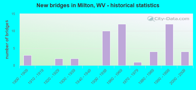
- New bridges - historical statistics
- 31900-1909
- 21920-1929
- 21930-1939
- 101950-1959
- 121960-1969
- 11970-1979
- 41980-1989
- 121990-1999
- 42000-2009

- Reconstructed bridges - Historical Statistics
- 21970-1979
- 01980-1989
- 71990-1999


- Bridge Condition - Deck
- 15.6%Good
- 56.3%Satisfactory
- 25.0%Fair
- 3.1%Poor

- Bridge Condition - Superstructure
- 25.0%Good
- 46.9%Satisfactory
- 25.0%Fair
- 3.1%Poor

- Bridge Condition - Substructure
- 15.6%Good
- 46.9%Satisfactory
- 34.4%Fair
- 3.1%Poor

- Bridge Condition - Channel
- 47.6%Good
- 42.9%Satisfactory
- 4.8%Fair
- 4.8%Poor

- Bridge Condition - Culverts
- 66.7%Satisfactory
- 33.3%Fair
Find on map >> Show street view
Structure Number: 6A009, Location: 0.01 MI SOUTH OF CR 18 (Lat: 38.480161, Lng: -82.199200), Route carried "on" structure: County highway 111, Year Built: 1989, Status: Open, Structure Length: 1.20m (3.94ft), Average Daily Traffic: 20 (year 2020), Truck Traffic: 8%, Average Future Daily Traffic: 24 (year 2040), Design Load: HS 20, Features Intersected: BIG CABELL CREEK, Facility Carried by Structure: CR 1/11
Minimum Vertical Clearance: 30+ m (98+ ft), Kilometerpoint: 7.934, Lanes on structure: 2, Owner: State Highway Agency, Approaching Roadway Width: 4.6m (15.1ft), Material/Design: Prestressed concrete, Design/Construction: Box Beam or Girders - Multiple, Number Of Spans In Main Unit: 1, Length of Maximum Span: 11.6m (38.1ft), Curb-To-Curb Width: 7.0m (23.0ft), Out-to-Out Width: 7.4m (24.3ft)
Condition: Deck: Satisfactory, Superstructure: Satisfactory, Substructure: Fair, Channel: Satisfactory, Operating Rating: 88.9 metric tons, Method Used To Determine Operating Rating: Load Factor (LF), Inventory Rating: 54.4 metric tons, Method Used To Determine Inventory Rating: Load Factor (LF), Structural Evaluation: Somewhat better than minimum adequacy, Deck Geometry: Somewhat better than minimum adequacy, Waterway Adequacy: Equal to present minimum criteria, Approach Roadway Alignment: Equal to present minimum criteria, Designated Inspection Frequency: Every 24 months, Inspection Date: December 2021, Deck Structure Type: Other, Wearing Surface/Protective System: Wearing Surface: Bituminous, Deck Protection: Epoxy Coated Reinforcing
Find on map >> Show street view
Structure Number: 6A021, Location: 0.24 MI SOUTH OF CR 9/2 (Lat: 38.443350, Lng: -82.162131), Route carried "on" structure: County highway 900, Year Built: 1931, Status: Open, Structure Length: 0.97m (3.18ft), Average Daily Traffic: 1,500 (year 2016), Truck Traffic: 7%, Average Future Daily Traffic: 1,905 (year 2039), Features Intersected: MILL CREEK, Facility Carried by Structure: CR 9
Minimum Vertical Clearance: 30+ m (98+ ft), Kilometerpoint: 2.736, Lanes on structure: 2, Owner: State Highway Agency, Approaching Roadway Width: 6.1m (20.0ft), Material/Design: Concrete, Design/Construction: Tee Beam, Number Of Spans In Main Unit: 1, Length of Maximum Span: 9.5m (31.2ft), Curb or Sidewalk Widths: Left: 0.2m (0.7ft), Right: 0.2m (0.7ft), Curb-To-Curb Width: 5.7m (18.7ft), Out-to-Out Width: 6.6m (21.7ft)
Condition: Deck: Satisfactory, Superstructure: Satisfactory, Substructure: Satisfactory, Channel: Satisfactory, Operating Rating: 63.5 metric tons, Method Used To Determine Operating Rating: Field evaluation and documented engineering judgment, Inventory Rating: 29.0 metric tons, Method Used To Determine Inventory Rating: Field evaluation and documented engineering judgment, Structural Evaluation: Equal to present minimum criteria, Deck Geometry: High priority of replacement, Waterway Adequacy: Better than present minimum criteria, Approach Roadway Alignment: Somewhat better than minimum adequacy, Length Of Structure Improvement: 0.98m (3.22ft), Designated Inspection Frequency: Every 24 months, Inspection Date: November 2020, Bridge Improvement Cost: $90,000, Roadway Improvement Cost: $20,000, Total Project Cost: $145,000 ( Estimate for 2015), Deck Structure Type: Concrete Cast-file-Place, Wearing Surface/Protective System: Wearing Surface: Bituminous
Find on map >> Show street view
Structure Number: 6A022, Location: 0.04 MI SOUTH OF CR 18 (Lat: 38.460061, Lng: -82.167900), Route carried "on" structure: County highway 900, Year Built: 1931, Status: Open, Structure Length: 0.94m (3.08ft), Average Daily Traffic: 500 (year 2019), Truck Traffic: 7%, Average Future Daily Traffic: 635 (year 2039), Features Intersected: LOWER CREEK, Facility Carried by Structure: CR 9
Minimum Vertical Clearance: 30+ m (98+ ft), Kilometerpoint: 5.134, Lanes on structure: 2, Owner: State Highway Agency, Approaching Roadway Width: 4.9m (16.1ft), Material/Design: Concrete, Design/Construction: Girder and Floorbeam System, Number Of Spans In Main Unit: 1, Length of Maximum Span: 9.1m (29.9ft), Curb or Sidewalk Widths: Left: 0.2m (0.7ft), Right: 0.2m (0.7ft), Curb-To-Curb Width: 5.5m (18.0ft), Out-to-Out Width: 6.6m (21.7ft)
Condition: Deck: Fair, Superstructure: Fair, Substructure: Fair, Channel: Satisfactory, Operating Rating: 63.5 metric tons, Method Used To Determine Operating Rating: Field evaluation and documented engineering judgment, Inventory Rating: 29.0 metric tons, Method Used To Determine Inventory Rating: Field evaluation and documented engineering judgment, Structural Evaluation: Somewhat better than minimum adequacy, Deck Geometry: High priority of replacement, Waterway Adequacy: Better than present minimum criteria, Approach Roadway Alignment: Better than present minimum criteria, Length Of Structure Improvement: 0.98m (3.22ft), Designated Inspection Frequency: Every 24 months, Underwater Inspection Frequency: Every 60 months, Inspection Date: March 2021, Underwater Inspection Date: June 2017, Bridge Improvement Cost: $90,000, Roadway Improvement Cost: $20,000, Total Project Cost: $145,000 ( Estimate for 2017), Deck Structure Type: Concrete Cast-file-Place, Wearing Surface/Protective System: Wearing Surface: Bituminous
Find on map >> Show street view
Structure Number: 6A036, Location: 1.67 MI.N. OF US 60 (Lat: 38.456289, Lng: -82.131211), Route carried "on" structure: County highway 1500, Year Built: 1987, Status: Open, Structure Length: 1.50m (4.92ft), Average Daily Traffic: 1,200 (year 2019), Truck Traffic: 7%, Average Future Daily Traffic: 1,294 (year 2039), Design Load: HS 25 or greater, Features Intersected: MILL CREEK, Facility Carried by Structure: CR 15
Minimum Vertical Clearance: 30+ m (98+ ft), Kilometerpoint: 2.688, Lanes on structure: 2, Owner: State Highway Agency, Approaching Roadway Width: 5.8m (19.0ft), Material/Design: Prestressed concrete, Design/Construction: Box Beam or Girders - Multiple, Number Of Spans In Main Unit: 1, Length of Maximum Span: 13.4m (44.0ft), Curb-To-Curb Width: 6.1m (20.0ft), Out-to-Out Width: 6.4m (21.0ft)
Condition: Deck: Satisfactory, Superstructure: Satisfactory, Substructure: Satisfactory, Channel: Satisfactory, Operating Rating: 88.9 metric tons, Method Used To Determine Operating Rating: Load Factor (LF), Inventory Rating: 57.1 metric tons, Method Used To Determine Inventory Rating: Load Factor (LF), Structural Evaluation: Equal to present minimum criteria, Deck Geometry: High priority of replacement, Waterway Adequacy: Equal to present desirable criteria, Approach Roadway Alignment: Better than present minimum criteria, Designated Inspection Frequency: Every 24 months, Inspection Date: May 2021, Deck Structure Type: Other, Wearing Surface/Protective System: Wearing Surface: Monolithic Concrete, Deck Protection: Epoxy Coated Reinforcing
Find on map >> Show street view
Structure Number: 6A037, Location: 0.01 MI SOUTH OF CR 9 (Lat: 38.481539, Lng: -82.150189), Route carried "on" structure: County highway 1500, Year Built: 1922, Status: Open, Structure Length: 0.98m (3.22ft), Average Daily Traffic: 1,100 (year 2018), Truck Traffic: 7%, Average Future Daily Traffic: 1,397 (year 2038), Features Intersected: RIGHT FORK OF LOWER CRK, Facility Carried by Structure: CR 15
Minimum Vertical Clearance: 30+ m (98+ ft), Kilometerpoint: 6.309, Lanes on structure: 2, Owner: State Highway Agency, Approaching Roadway Width: 5.2m (17.1ft), Skew: 1 degrees, Material/Design: Concrete, Design/Construction: Girder and Floorbeam System, Number Of Spans In Main Unit: 1, Length of Maximum Span: 9.5m (31.2ft), Curb or Sidewalk Widths: Left: 0.2m (0.7ft), Right: 0.2m (0.7ft), Curb-To-Curb Width: 6.3m (20.7ft), Out-to-Out Width: 6.8m (22.3ft)
Condition: Deck: Fair, Superstructure: Fair, Substructure: Fair, Channel: Satisfactory, Operating Rating: 47.2 metric tons, Method Used To Determine Operating Rating: Field evaluation and documented engineering judgment, Inventory Rating: 21.8 metric tons, Method Used To Determine Inventory Rating: Field evaluation and documented engineering judgment, Structural Evaluation: Somewhat better than minimum adequacy, Deck Geometry: High priority of replacement, Waterway Adequacy: Equal to present minimum criteria, Approach Roadway Alignment: Equal to present minimum criteria, Length Of Structure Improvement: 1.01m (3.31ft), Designated Inspection Frequency: Every 24 months, Inspection Date: July 2020, Bridge Improvement Cost: $95,000, Roadway Improvement Cost: $20,000, Total Project Cost: $140,000 ( Estimate for 2018), Deck Structure Type: Concrete Cast-file-Place, Wearing Surface/Protective System: Wearing Surface: Bituminous
Find on map >> Show street view
Structure Number: 6A038, Location: 0.64 MI SOUTH OF CR 16/1 (Lat: 38.442050, Lng: -82.091361), Route carried "on" structure: County highway 1600, Year Built: 1950, Status: Open, Structure Length: 1.00m (3.28ft), Average Daily Traffic: 350 (year 2020), Truck Traffic: 8%, Average Future Daily Traffic: 424 (year 2040), Features Intersected: KILGORE CREEK, Facility Carried by Structure: CR 16
Minimum Vertical Clearance: 30+ m (98+ ft), Kilometerpoint: 2.253, Lanes on structure: 1, Owner: State Highway Agency, Approaching Roadway Width: 4.3m (14.1ft), Skew: 1 degrees, Material/Design: Concrete, Design/Construction: Girder and Floorbeam System, Number Of Spans In Main Unit: 1, Length of Maximum Span: 9.5m (31.2ft), Curb or Sidewalk Widths: Left: 0.2m (0.7ft), Right: 0.2m (0.7ft), Curb-To-Curb Width: 4.8m (15.7ft), Out-to-Out Width: 5.9m (19.4ft)
Condition: Deck: Fair, Superstructure: Fair, Substructure: Fair, Channel: Poor, Operating Rating: 48.1 metric tons, Method Used To Determine Operating Rating: Field evaluation and documented engineering judgment, Inventory Rating: 21.8 metric tons, Method Used To Determine Inventory Rating: Field evaluation and documented engineering judgment, Structural Evaluation: Somewhat better than minimum adequacy, Deck Geometry: High priority of corrective action, Waterway Adequacy: Equal to present minimum criteria, Approach Roadway Alignment: Somewhat better than minimum adequacy, Length Of Structure Improvement: 1.01m (3.31ft), Designated Inspection Frequency: Every 24 months, Inspection Date: December 2021, Bridge Improvement Cost: $95,000, Roadway Improvement Cost: $20,000, Total Project Cost: $140,000 ( Estimate for 2018), Deck Structure Type: Concrete Cast-file-Place, Wearing Surface/Protective System: Wearing Surface: Bituminous
Find on map >> Show street view
Structure Number: 6A06, Location: 0.01 MI SOUTH OF CR 25/2 (Lat: 38.423939, Lng: -82.122511), Route carried "on" structure: County highway 2500, Year Built: 1990, Status: Open, Structure Length: 5.16m (16.93ft), Average Daily Traffic: 1,912 (year 2019), Truck Traffic: 7%, Average Future Daily Traffic: 2,428 (year 2039), Design Load: HS 20, Features Intersected: MUD RIVER, Facility Carried by Structure: CR 25
Minimum Vertical Clearance: 30+ m (98+ ft), Kilometerpoint: 12.633, Lanes on structure: 2, Owner: State Highway Agency, Approaching Roadway Width: 9.1m (29.9ft), Material/Design: Steel continuous, Design/Construction: Stringer/Multi-beam, Number Of Spans In Main Unit: 1, Number Of Approach Spans: 2, Length of Maximum Span: 22.9m (75.1ft), Curb-To-Curb Width: 8.2m (26.9ft), Out-to-Out Width: 9.2m (30.2ft)
Condition: Deck: Satisfactory, Superstructure: Satisfactory, Substructure: Satisfactory, Channel: Good, Operating Rating: 77.1 metric tons, Method Used To Determine Operating Rating: Load Factor (LF), Inventory Rating: 45.4 metric tons, Method Used To Determine Inventory Rating: Load Factor (LF), Structural Evaluation: Equal to present minimum criteria, Deck Geometry: Meets minimum limits, Waterway Adequacy: Equal to present minimum criteria, Approach Roadway Alignment: Better than present minimum criteria, Length Of Structure Improvement: 5.15m (16.90ft), Designated Inspection Frequency: Every 24 months, Inspection Date: Febuary 2021, Bridge Improvement Cost: $198,000, Roadway Improvement Cost: $52,000, Total Project Cost: $250,000 ( Estimate for 2017), Deck Structure Type: Concrete Cast-file-Place, Wearing Surface/Protective System: Wearing Surface: Monolithic Concrete, Deck Protection: Epoxy Coated Reinforcing
Find on map >> Show street view
Structure Number: 6A063, Location: 0.18 MI SOUTH OF US 60 (Lat: 38.432211, Lng: -82.133400), Route carried "on" structure: County highway 2507, Year Built: 1976, Status: Open, Structure Length: 12.88m (42.26ft), Average Daily Traffic: 4,174 (year 2019), Truck Traffic: 7%, Average Future Daily Traffic: 5,301 (year 2039), Design Load: HS 20+Mod, Features Intersected: MUD RIVER, Facility Carried by Structure: CR 25/7
Minimum Vertical Clearance: 30+ m (98+ ft), Kilometerpoint: 0.531, Lanes on structure: 2, Owner: State Highway Agency, Approaching Roadway Width: 6.1m (20.0ft), Material/Design: Steel continuous, Design/Construction: Stringer/Multi-beam, Number Of Spans In Main Unit: 1, Number Of Approach Spans: 2, Length of Maximum Span: 48.8m (160.1ft), Curb-To-Curb Width: 8.1m (26.6ft), Out-to-Out Width: 9.4m (30.8ft)
Condition: Deck: Fair, Superstructure: Good, Substructure: Satisfactory, Channel: Good, Operating Rating: 65.3 metric tons, Method Used To Determine Operating Rating: Load Factor (LF), Inventory Rating: 39.0 metric tons, Method Used To Determine Inventory Rating: Load Factor (LF), Structural Evaluation: Equal to present minimum criteria, Deck Geometry: High priority of corrective action, Waterway Adequacy: Equal to present minimum criteria, Approach Roadway Alignment: Equal to present desirable criteria, Length Of Structure Improvement: 12.89m (42.29ft), Designated Inspection Frequency: Every 24 months, Inspection Date: August 2020, Bridge Improvement Cost: $846,000, Roadway Improvement Cost: $100,000, Total Project Cost: $1,056,000 ( Estimate for 2018), Deck Structure Type: Concrete Cast-file-Place, Wearing Surface/Protective System: Wearing Surface: Monolithic Concrete, Deck Protection: Epoxy Coated Reinforcing
Find on map >> Show street view
Structure Number: 6A071, Location: 0.04 MI SOUTH OF CR 34 (Lat: 38.396411, Lng: -82.177239), Route carried "on" structure: County highway 2900, Year Built: 1929, Status: Open, Structure Length: 1.04m (3.41ft), Average Daily Traffic: 600 (year 2018), Truck Traffic: 7%, Average Future Daily Traffic: 762 (year 2038), Features Intersected: FUDGES CREEK, Facility Carried by Structure: CR 29
Minimum Vertical Clearance: 30+ m (98+ ft), Kilometerpoint: 10.123, Lanes on structure: 2, Owner: State Highway Agency, Approaching Roadway Width: 6.7m (22.0ft), Skew: 4 degrees, Material/Design: Concrete, Design/Construction: Tee Beam, Number Of Spans In Main Unit: 1, Length of Maximum Span: 10.1m (33.1ft), Curb or Sidewalk Widths: Left: 0.2m (0.7ft), Right: 0.2m (0.7ft), Curb-To-Curb Width: 5.5m (18.0ft), Out-to-Out Width: 6.0m (19.7ft)
Condition: Deck: Fair, Superstructure: Fair, Substructure: Fair, Channel: Satisfactory, Operating Rating: 63.5 metric tons, Method Used To Determine Operating Rating: Field evaluation and documented engineering judgment, Inventory Rating: 29.0 metric tons, Method Used To Determine Inventory Rating: Field evaluation and documented engineering judgment, Structural Evaluation: Somewhat better than minimum adequacy, Deck Geometry: High priority of replacement, Waterway Adequacy: Somewhat better than minimum adequacy, Approach Roadway Alignment: Somewhat better than minimum adequacy, Length Of Structure Improvement: 1.07m (3.51ft), Designated Inspection Frequency: Every 24 months, Inspection Date: October 2020, Bridge Improvement Cost: $95,000, Roadway Improvement Cost: $20,000, Total Project Cost: $150,000 ( Estimate for 2016), Deck Structure Type: Concrete Cast-file-Place, Wearing Surface/Protective System: Wearing Surface: Bituminous
Find on map >> Show street view
Structure Number: 6A074, Location: 0.02 MI. S. OF CR 29 (Lat: 38.399619, Lng: -82.200039), Route carried "on" structure: County highway 2902, Year Built: 1987, Status: Open, Structure Length: 0.96m (3.15ft), Average Daily Traffic: 30 (year 2019), Truck Traffic: 7%, Average Future Daily Traffic: 33 (year 2039), Design Load: HS 20, Features Intersected: FUDGES CREEK, Facility Carried by Structure: CR 29/2
Minimum Vertical Clearance: 30+ m (98+ ft), Kilometerpoint: 0.032, Lanes on structure: 1, Owner: State Highway Agency, Approaching Roadway Width: 4.3m (14.1ft), Material/Design: Prestressed concrete, Design/Construction: Box Beam or Girders - Multiple, Number Of Spans In Main Unit: 1, Length of Maximum Span: 9.1m (29.9ft), Curb-To-Curb Width: 4.3m (14.1ft), Out-to-Out Width: 4.6m (15.1ft)
Condition: Deck: Good, Superstructure: Good, Substructure: Good, Channel: Satisfactory, Operating Rating: 88.9 metric tons, Method Used To Determine Operating Rating: Load Factor (LF), Inventory Rating: 59.0 metric tons, Method Used To Determine Inventory Rating: Load Factor (LF), Structural Evaluation: Better than present minimum criteria, Deck Geometry: Equal to present minimum criteria, Waterway Adequacy: Equal to present minimum criteria, Approach Roadway Alignment: Somewhat better than minimum adequacy, Length Of Structure Improvement: 0.98m (3.22ft), Designated Inspection Frequency: Every 48 months, Inspection Date: April 2021, Bridge Improvement Cost: $10,000, Roadway Improvement Cost: $1,000, Total Project Cost: $15,000 ( Estimate for 2017), Deck Structure Type: Other, Wearing Surface/Protective System: Wearing Surface: Monolithic Concrete
Find on map >> Show street view
Structure Number: 6A123, Location: 0.17 MI EAST OF CR 60/13 (Lat: 38.431061, Lng: -82.159039), Route carried "on" structure: US 6000, Year Built: 1989, Status: Open, Structure Length: 12.43m (40.78ft), Average Daily Traffic: 7,700 (year 2018), Truck Traffic: 5%, Average Future Daily Traffic: 10,010 (year 2038), Design Load: HS 20, Features Intersected: MUD RIVER & CSX RAILROAD, Facility Carried by Structure: US 60
Minimum Vertical Clearance: 30+ m (98+ ft), Kilometerpoint: 32.975, Lanes on structure: 2, Owner: State Highway Agency, Approaching Roadway Width: 7.6m (24.9ft), Skew: 2 degrees, Material/Design: Steel continuous, Design/Construction: Stringer/Multi-beam, Number Of Spans In Main Unit: 1, Number Of Approach Spans: 2, Length of Maximum Span: 47.2m (154.9ft), Curb-To-Curb Width: 9.4m (30.8ft), Out-to-Out Width: 10.5m (34.4ft)
Condition: Deck: Satisfactory, Superstructure: Satisfactory, Substructure: Satisfactory, Channel: Good, Operating Rating: 80.7 metric tons, Method Used To Determine Operating Rating: Load Factor (LF), Inventory Rating: 48.1 metric tons, Method Used To Determine Inventory Rating: Load Factor (LF), Structural Evaluation: Equal to present minimum criteria, Deck Geometry: Meets minimum limits, Underclear: Equal to present desirable criteria, Waterway Adequacy: Equal to present desirable criteria, Approach Roadway Alignment: Better than present minimum criteria, Designated Inspection Frequency: Every 24 months, Inspection Date: November 2020, Deck Structure Type: Concrete Cast-file-Place, Wearing Surface/Protective System: Wearing Surface: Integral Concrete, Membrane: Epoxy, Deck Protection: Epoxy Coated Reinforcing
Find on map >> Show street view
Structure Number: 6A126, Location: 0.04 MI NORTH OF CR 60/91 (Lat: 38.434331, Lng: -82.176719), Route carried "on" structure: County highway 6028, Year Built: 1960, Status: Open, Structure Length: 9.30m (30.51ft), Average Daily Traffic: 300 (year 2018), Truck Traffic: 7%, Average Future Daily Traffic: 377 (year 2038), Design Load: H 20, Features Intersected: Interstate 64, Facility Carried by Structure: CR 60/28
Minimum Vertical Clearance: 30+ m (98+ ft), Kilometerpoint: 0.386, Lanes on structure: 2, Lanes under structure: 4, Owner: State Highway Agency, Approaching Roadway Width: 10.7m (35.1ft), Skew: 2 degrees, Material/Design: Steel continuous, Design/Construction: Stringer/Multi-beam, Number Of Spans In Main Unit: 1, Number Of Approach Spans: 3, Length of Maximum Span: 25.8m (84.6ft), Curb or Sidewalk Widths: Left: 0.8m (2.6ft), Right: 0.8m (2.6ft), Curb-To-Curb Width: 7.3m (24.0ft), Out-to-Out Width: 9.5m (31.2ft)
Condition: Deck: Fair, Superstructure: Fair, Substructure: Satisfactory, Operating Rating: 61.7 metric tons, Method Used To Determine Operating Rating: Load Factor (LF), Inventory Rating: 37.2 metric tons, Method Used To Determine Inventory Rating: Load Factor (LF), Structural Evaluation: Somewhat better than minimum adequacy, Deck Geometry: Somewhat better than minimum adequacy, Underclear: High priority of corrective action, Approach Roadway Alignment: Equal to present desirable criteria, Length Of Structure Improvement: 9.30m (30.51ft), Designated Inspection Frequency: Every 24 months, Inspection Date: Febuary 2020, Bridge Improvement Cost: $439,000, Roadway Improvement Cost: $50,000, Total Project Cost: $568,000 ( Estimate for 2016), Deck Structure Type: Concrete Cast-file-Place, Wearing Surface/Protective System: Wearing Surface: Latex Concrete, Membrane: Built-up
Find on map >> Show street view
Structure Number: 6A157, Location: 1.16 MI EAST OF CR 16 (Lat: 38.430150, Lng: -82.104631), Route carried "on" structure: Interstate 6400, Year Built: 1959, Year Reconstructed: 1978, Status: Open, Structure Length: 4.01m (13.16ft), Average Daily Traffic: 18,454 (year 2018), Truck Traffic: 17%, Average Future Daily Traffic: 28,419 (year 2038), Design Load: HS 20+Mod, Features Intersected: COUNTY ROUTE 16, Facility Carried by Structure: I 64 EB
Minimum Vertical Clearance: 30+ m (98+ ft), Kilometerpoint: 46.140, Lanes on structure: 2, Lanes under structure: 2, Base Highway Network: Yes, Owner: State Highway Agency, Approaching Roadway Width: 11.9m (39.0ft), Skew: 2 degrees, Material/Design: Steel continuous, Design/Construction: Stringer/Multi-beam, Number Of Spans In Main Unit: 1, Number Of Approach Spans: 2, Length of Maximum Span: 15.4m (50.5ft), Curb or Sidewalk Widths: Left: 0.6m (2.0ft), Right: 0.6m (2.0ft), Curb-To-Curb Width: 11.6m (38.1ft), Out-to-Out Width: 12.9m (42.3ft)
Condition: Deck: Satisfactory, Superstructure: Satisfactory, Substructure: Satisfactory, Operating Rating: 82.5 metric tons, Method Used To Determine Operating Rating: Load Factor (LF), Inventory Rating: 49.9 metric tons, Method Used To Determine Inventory Rating: Load Factor (LF), Structural Evaluation: Equal to present minimum criteria, Deck Geometry: Equal to present minimum criteria, Underclear: High priority of corrective action, Approach Roadway Alignment: Equal to present desirable criteria, Designated Inspection Frequency: Every 24 months, Inspection Date: July 2020, Deck Structure Type: Concrete Cast-file-Place, Wearing Surface/Protective System: Wearing Surface: Monolithic Concrete, Deck Protection: Epoxy Coated Reinforcing
Find on map >> Show street view
Structure Number: 6A202, Location: 1.16 MI EAST OF CR 13 (Lat: 38.430281, Lng: -82.104419), Route carried "on" structure: Interstate 6400, Year Built: 1959, Year Reconstructed: 1978, Status: Open, Structure Length: 4.01m (13.16ft), Average Daily Traffic: 18,454 (year 2018), Truck Traffic: 17%, Average Future Daily Traffic: 28,419 (year 2038), Design Load: HS 20+Mod, Features Intersected: COUNTY ROUTE 16, Facility Carried by Structure: I 64 WB
Minimum Vertical Clearance: 30+ m (98+ ft), Kilometerpoint: 46.140, Lanes on structure: 2, Lanes under structure: 2, Base Highway Network: Yes, Owner: State Highway Agency, Approaching Roadway Width: 11.9m (39.0ft), Skew: 2 degrees, Material/Design: Steel continuous, Design/Construction: Stringer/Multi-beam, Number Of Spans In Main Unit: 1, Number Of Approach Spans: 2, Length of Maximum Span: 15.4m (50.5ft), Curb or Sidewalk Widths: Left: 0.6m (2.0ft), Right: 0.6m (2.0ft), Curb-To-Curb Width: 11.7m (38.4ft), Out-to-Out Width: 12.9m (42.3ft)
Condition: Deck: Satisfactory, Superstructure: Satisfactory, Substructure: Satisfactory, Operating Rating: 82.5 metric tons, Method Used To Determine Operating Rating: Load Factor (LF), Inventory Rating: 49.9 metric tons, Method Used To Determine Inventory Rating: Load Factor (LF), Structural Evaluation: Equal to present minimum criteria, Deck Geometry: Equal to present minimum criteria, Underclear: High priority of corrective action, Approach Roadway Alignment: Better than present minimum criteria, Designated Inspection Frequency: Every 24 months, Inspection Date: July 2020, Deck Structure Type: Concrete Cast-file-Place, Wearing Surface/Protective System: Wearing Surface: Monolithic Concrete, Deck Protection: Epoxy Coated Reinforcing
Find on map >> Show street view
Structure Number: 6A212, Location: 0.08 MI WEST OF CR 60/10 (Lat: 38.428111, Lng: -82.202761), Route carried "on" structure: US 6000, Year Built: 1954, Status: Open, Structure Length: 1.07m (3.51ft), Average Daily Traffic: 15,000 (year 2018), Truck Traffic: 5%, Average Future Daily Traffic: 19,500 (year 2038), Features Intersected: FUDGES CREEK, Facility Carried by Structure: US 60
Minimum Vertical Clearance: 30+ m (98+ ft), Kilometerpoint: 28.968, Lanes on structure: 2, Owner: State Highway Agency, Approaching Roadway Width: 12.2m (40.0ft), Skew: 3 degrees, Material/Design: Concrete continuous, Design/Construction: Culvert, Number Of Spans In Main Unit: 3, Length of Maximum Span: 2.7m (8.9ft)
Condition: Channel: Fair, Culverts: Fair, Operating Rating: 53.5 metric tons, Method Used To Determine Operating Rating: Field evaluation and documented engineering judgment, Inventory Rating: 24.5 metric tons, Method Used To Determine Inventory Rating: Field evaluation and documented engineering judgment, Structural Evaluation: Somewhat better than minimum adequacy, Waterway Adequacy: Equal to present minimum criteria, Approach Roadway Alignment: Equal to present desirable criteria, Length Of Structure Improvement: 1.07m (3.51ft), Designated Inspection Frequency: Every 24 months, Inspection Date: Febuary 2020, Bridge Improvement Cost: $500,000, Roadway Improvement Cost: $100,000, Total Project Cost: $600,000 ( Estimate for 2020)
Find on map >> Show street view
Structure Number: 6A219, Location: 0.01 MI EAST OF CR 29 (Lat: 38.395850, Lng: -82.187319), Route carried "on" structure: County highway 2903, Year Built: 1994, Status: Open, Structure Length: 0.75m (2.46ft), Average Daily Traffic: 50 (year 2020), Truck Traffic: 8%, Average Future Daily Traffic: 61 (year 2040), Design Load: HS 25 or greater, Features Intersected: FUDGES CREEK, Facility Carried by Structure: CR 29/3
Minimum Vertical Clearance: 30+ m (98+ ft), Kilometerpoint: 0.016, Lanes on structure: 2, Owner: State Highway Agency, Approaching Roadway Width: 3.4m (11.2ft), Material/Design: Prestressed concrete, Design/Construction: Box Beam or Girders - Multiple, Number Of Spans In Main Unit: 1, Length of Maximum Span: 7.0m (23.0ft), Curb-To-Curb Width: 6.9m (22.6ft), Out-to-Out Width: 7.5m (24.6ft)
Condition: Deck: Satisfactory, Superstructure: Satisfactory, Substructure: Good, Channel: Good, Operating Rating: 88.9 metric tons, Method Used To Determine Operating Rating: Load Factor (LF), Inventory Rating: 61.7 metric tons, Method Used To Determine Inventory Rating: Load Factor (LF), Structural Evaluation: Equal to present minimum criteria, Deck Geometry: Somewhat better than minimum adequacy, Waterway Adequacy: Better than present minimum criteria, Approach Roadway Alignment: Better than present minimum criteria, Designated Inspection Frequency: Every 48 months, Inspection Date: July 2021, Deck Structure Type: Other, Wearing Surface/Protective System: Wearing Surface: Bituminous, Membrane: Other, Deck Protection: Epoxy Coated Reinforcing
Find on map >> Show street view
Structure Number: 6A225, Location: 0.01 MILE WEST OF CR 9 (Lat: 38.452050, Lng: -82.168411), Route carried "on" structure: County highway 2100, Year Built: 1996, Status: Open, Structure Length: 2.18m (7.15ft), Average Daily Traffic: 300 (year 2016), Truck Traffic: 4%, Average Future Daily Traffic: 381 (year 2036), Design Load: HS 25 or greater, Features Intersected: LOWER CREEK, Facility Carried by Structure: CR 21
Minimum Vertical Clearance: 30+ m (98+ ft), Kilometerpoint: 4.796, Lanes on structure: 2, Owner: State Highway Agency, Approaching Roadway Width: 7.9m (25.9ft), Skew: 3 degrees, Material/Design: Prestressed concrete, Design/Construction: Box Beam or Girders - Multiple, Number Of Spans In Main Unit: 1, Length of Maximum Span: 21.3m (69.9ft), Curb-To-Curb Width: 7.2m (23.6ft), Out-to-Out Width: 7.5m (24.6ft)
Condition: Deck: Good, Superstructure: Good, Substructure: Good, Channel: Good, Operating Rating: 80.7 metric tons, Method Used To Determine Operating Rating: Load Factor (LF), Inventory Rating: 48.1 metric tons, Method Used To Determine Inventory Rating: Load Factor (LF), Structural Evaluation: Better than present minimum criteria, Deck Geometry: Meets minimum limits, Waterway Adequacy: Better than present minimum criteria, Approach Roadway Alignment: Equal to present minimum criteria, Designated Inspection Frequency: Every 48 months, Inspection Date: August 2018, Deck Structure Type: Other, Wearing Surface/Protective System: Wearing Surface: Bituminous, Deck Protection: Epoxy Coated Reinforcing
Find on map >> Show street view
Structure Number: 6A231, Location: 2.02 MI. W. OF CR 13 EXIT (Lat: 38.436550, Lng: -82.163219), Route carried "on" structure: Interstate 6400, Year Built: 1961, Year Reconstructed: 1996, Status: Open, Structure Length: 13.76m (45.14ft), Average Daily Traffic: 18,988 (year 2018), Truck Traffic: 17%, Average Future Daily Traffic: 29,242 (year 2038), Design Load: HS 25 or greater, Features Intersected: CSX RR & MUD RIVER, Facility Carried by Structure: I64 EB
Minimum Vertical Clearance: 30+ m (98+ ft), Kilometerpoint: 40.572, Lanes on structure: 2, Base Highway Network: Yes, Owner: State Highway Agency, Approaching Roadway Width: 12.2m (40.0ft), Skew: 12 degrees, Material/Design: Steel continuous, Design/Construction: Stringer/Multi-beam, Number Of Spans In Main Unit: 1, Number Of Approach Spans: 4, Length of Maximum Span: 38.1m (125.0ft), Curb-To-Curb Width: 9.8m (32.2ft), Out-to-Out Width: 10.8m (35.4ft)
Condition: Deck: Fair, Superstructure: Fair, Substructure: Fair, Channel: Good, Operating Rating: 72.6 metric tons, Method Used To Determine Operating Rating: Load Factor (LF), Inventory Rating: 43.5 metric tons, Method Used To Determine Inventory Rating: Load Factor (LF), Structural Evaluation: Somewhat better than minimum adequacy, Deck Geometry: Meets minimum limits, Underclear: Better than present minimum criteria, Waterway Adequacy: Equal to present minimum criteria, Approach Roadway Alignment: Better than present minimum criteria, Designated Inspection Frequency: Every 24 months, Critical Feature Inspection Frequency: Every 24 months, Inspection Date: April 2020, Critical Feature Inspection Date: April 2020, Deck Structure Type: Concrete Cast-file-Place, Wearing Surface/Protective System: Wearing Surface: Monolithic Concrete, Deck Protection: Epoxy Coated Reinforcing
Find on map >> Show street view
Structure Number: 6A232, Location: 1.06 MI. WEST OF CR 13 (Lat: 38.440289, Lng: -82.141139), Route carried "on" structure: Interstate 6400, Year Built: 1960, Year Reconstructed: 1996, Status: Open, Structure Length: 8.29m (27.20ft), Average Daily Traffic: 16,750 (year 2018), Truck Traffic: 17%, Average Future Daily Traffic: 25,795 (year 2038), Design Load: HS 25 or greater, Features Intersected: COUNTY RT. 9, Facility Carried by Structure: I64 EB
Minimum Vertical Clearance: 30+ m (98+ ft), Kilometerpoint: 42.567, Lanes on structure: 2, Lanes under structure: 2, Base Highway Network: Yes, Owner: State Highway Agency, Approaching Roadway Width: 13.7m (44.9ft), Skew: 4 degrees, Material/Design: Steel continuous, Design/Construction: Stringer/Multi-beam, Number Of Spans In Main Unit: 1, Number Of Approach Spans: 2, Length of Maximum Span: 32.6m (107.0ft), Curb-To-Curb Width: 9.8m (32.2ft), Out-to-Out Width: 10.7m (35.1ft)
Condition: Deck: Satisfactory, Superstructure: Satisfactory, Substructure: Poor, Operating Rating: 88.9 metric tons, Method Used To Determine Operating Rating: Load Factor (LF), Inventory Rating: 88.9 metric tons, Method Used To Determine Inventory Rating: Load Factor (LF), Structural Evaluation: Meets minimum limits, Deck Geometry: Meets minimum limits, Underclear: High priority of replacement, Approach Roadway Alignment: Equal to present desirable criteria, Length Of Structure Improvement: 3.35m (10.99ft), Designated Inspection Frequency: Every 24 months, Inspection Date: September 2020, Bridge Improvement Cost: $1,300,000, Roadway Improvement Cost: $250,000, Total Project Cost: $1,550,000 ( Estimate for 2020), Deck Structure Type: Concrete Cast-file-Place, Wearing Surface/Protective System: Wearing Surface: Integral Concrete, Membrane: Epoxy, Deck Protection: Epoxy Coated Reinforcing
Find on map >> Show street view
Structure Number: 6A233, Location: 0.44 MI. WEST OF CR 13 (Lat: 38.441539, Lng: -82.130081), Route carried "on" structure: Interstate 6400, Year Built: 1996, Status: Open, Structure Length: 6.43m (21.10ft), Average Daily Traffic: 16,750 (year 2017), Truck Traffic: 17%, Average Future Daily Traffic: 25,795 (year 2037), Design Load: HS 25 or greater, Features Intersected: County Route 15, Facility Carried by Structure: I64 EB
Minimum Vertical Clearance: 30+ m (98+ ft), Kilometerpoint: 43.565, Lanes on structure: 2, Lanes under structure: 2, Base Highway Network: Yes, Owner: State Highway Agency, Approaching Roadway Width: 13.7m (44.9ft), Skew: 11 degrees, Material/Design: Steel continuous, Design/Construction: Stringer/Multi-beam, Number Of Spans In Main Unit: 1, Number Of Approach Spans: 2, Length of Maximum Span: 25.3m (83.0ft), Curb-To-Curb Width: 9.8m (32.2ft), Out-to-Out Width: 10.8m (35.4ft)
Condition: Deck: Satisfactory, Superstructure: Satisfactory, Substructure: Satisfactory, Operating Rating: 88.9 metric tons, Method Used To Determine Operating Rating: Load Factor (LF), Inventory Rating: 62.6 metric tons, Method Used To Determine Inventory Rating: Load Factor (LF), Structural Evaluation: Equal to present minimum criteria, Deck Geometry: Meets minimum limits, Underclear: Superior to present desirable criteria, Approach Roadway Alignment: Better than present minimum criteria, Designated Inspection Frequency: Every 24 months, Inspection Date: September 2020, Deck Structure Type: Concrete Cast-file-Place, Wearing Surface/Protective System: Wearing Surface: Integral Concrete, Membrane: Epoxy, Deck Protection: Cathodic Protection
Find on map >> Show street view
Structure Number: 6A234, Location: 2.02 MI. W. OF CR 13 ENTR (Lat: 38.436719, Lng: -82.163289), Route carried "on" structure: Interstate 6400, Year Built: 1961, Year Reconstructed: 1997, Status: Open, Structure Length: 13.76m (45.14ft), Average Daily Traffic: 18,988 (year 2018), Truck Traffic: 17%, Average Future Daily Traffic: 29,242 (year 2038), Design Load: HS 25 or greater, Features Intersected: CSX RAILROAD & MUD RIVER, Facility Carried by Structure: I64 WB
Minimum Vertical Clearance: 30+ m (98+ ft), Kilometerpoint: 40.572, Lanes on structure: 2, Base Highway Network: Yes, Owner: State Highway Agency, Approaching Roadway Width: 12.2m (40.0ft), Skew: 12 degrees, Material/Design: Steel continuous, Design/Construction: Stringer/Multi-beam, Number Of Spans In Main Unit: 1, Number Of Approach Spans: 4, Length of Maximum Span: 38.1m (125.0ft), Curb-To-Curb Width: 9.8m (32.2ft), Out-to-Out Width: 10.8m (35.4ft)
Condition: Deck: Fair, Superstructure: Fair, Substructure: Fair, Channel: Good, Operating Rating: 72.6 metric tons, Method Used To Determine Operating Rating: Load Factor (LF), Inventory Rating: 43.5 metric tons, Method Used To Determine Inventory Rating: Load Factor (LF), Structural Evaluation: Somewhat better than minimum adequacy, Deck Geometry: Meets minimum limits, Underclear: Better than present minimum criteria, Waterway Adequacy: Equal to present minimum criteria, Approach Roadway Alignment: Equal to present desirable criteria, Designated Inspection Frequency: Every 24 months, Critical Feature Inspection Frequency: Every 24 months, Inspection Date: April 2020, Critical Feature Inspection Date: April 2020, Deck Structure Type: Concrete Cast-file-Place, Wearing Surface/Protective System: Wearing Surface: Monolithic Concrete, Deck Protection: Epoxy Coated Reinforcing
Find on map >> Show street view
Structure Number: 6A235, Location: 1.06 MI. WEST OF CR 13 (Lat: 38.440431, Lng: -82.141350), Route carried "on" structure: Interstate 6400, Year Built: 1960, Year Reconstructed: 1996, Status: Open, Structure Length: 8.29m (27.20ft), Average Daily Traffic: 16,750 (year 2018), Truck Traffic: 17%, Average Future Daily Traffic: 25,795 (year 2038), Design Load: HS 25 or greater, Features Intersected: COUNTY RT. 9, Facility Carried by Structure: I64 WB
Minimum Vertical Clearance: 30+ m (98+ ft), Kilometerpoint: 42.567, Lanes on structure: 2, Lanes under structure: 2, Base Highway Network: Yes, Owner: State Highway Agency, Approaching Roadway Width: 13.7m (44.9ft), Skew: 14 degrees, Material/Design: Steel continuous, Design/Construction: Stringer/Multi-beam, Number Of Spans In Main Unit: 1, Number Of Approach Spans: 2, Length of Maximum Span: 32.6m (107.0ft), Curb-To-Curb Width: 9.8m (32.2ft), Out-to-Out Width: 10.8m (35.4ft)
Condition: Deck: Satisfactory, Superstructure: Fair, Substructure: Satisfactory, Operating Rating: 88.9 metric tons, Method Used To Determine Operating Rating: Load Factor (LF), Inventory Rating: 88.9 metric tons, Method Used To Determine Inventory Rating: Load Factor (LF), Structural Evaluation: Somewhat better than minimum adequacy, Deck Geometry: Meets minimum limits, Underclear: High priority of corrective action, Approach Roadway Alignment: Equal to present desirable criteria, Designated Inspection Frequency: Every 24 months, Inspection Date: September 2020, Deck Structure Type: Concrete Cast-file-Place, Wearing Surface/Protective System: Wearing Surface: Integral Concrete, Membrane: Epoxy, Deck Protection: Epoxy Coated Reinforcing
Find on map >> Show street view
Structure Number: 6A236, Location: 0.44 MI. WEST OF CR 13 (Lat: 38.441719, Lng: -82.130081), Route carried "on" structure: Interstate 6400, Year Built: 1959, Year Reconstructed: 1996, Status: Open, Structure Length: 6.43m (21.10ft), Average Daily Traffic: 16,750 (year 2017), Truck Traffic: 17%, Average Future Daily Traffic: 25,795 (year 2037), Design Load: HS 25 or greater, Features Intersected: COUNTY ROUTE 15, Facility Carried by Structure: I64 WB
Minimum Vertical Clearance: 30+ m (98+ ft), Kilometerpoint: 43.565, Lanes on structure: 2, Lanes under structure: 2, Base Highway Network: Yes, Owner: State Highway Agency, Approaching Roadway Width: 13.7m (44.9ft), Skew: 11 degrees, Material/Design: Steel continuous, Design/Construction: Stringer/Multi-beam, Number Of Spans In Main Unit: 1, Number Of Approach Spans: 2, Length of Maximum Span: 25.3m (83.0ft), Curb-To-Curb Width: 9.8m (32.2ft), Out-to-Out Width: 10.8m (35.4ft)
Condition: Deck: Satisfactory, Superstructure: Satisfactory, Substructure: Fair, Operating Rating: 88.9 metric tons, Method Used To Determine Operating Rating: Load Factor (LF), Inventory Rating: 62.6 metric tons, Method Used To Determine Inventory Rating: Load Factor (LF), Structural Evaluation: Somewhat better than minimum adequacy, Deck Geometry: Meets minimum limits, Underclear: Superior to present desirable criteria, Approach Roadway Alignment: Better than present minimum criteria, Designated Inspection Frequency: Every 24 months, Inspection Date: September 2020, Deck Structure Type: Concrete Cast-file-Place, Wearing Surface/Protective System: Wearing Surface: Integral Concrete, Membrane: Epoxy, Deck Protection: Epoxy Coated Reinforcing
Find on map >> Show street view
Structure Number: 6A242, Location: 1.75 MI. E. OF CR 60/89 (Lat: 38.429539, Lng: -82.225900), Route carried "on" structure: Interstate 6400, Year Built: 1998, Status: Open, Structure Length: 11.39m (37.37ft), Average Daily Traffic: 33,750 (year 2019), Truck Traffic: 17%, Average Future Daily Traffic: 51,975 (year 2039), Design Load: HS 25 or greater, Features Intersected: MUD RIVER & CO 1, Facility Carried by Structure: I64 (EB)
Minimum Vertical Clearance: 30+ m (98+ ft), Kilometerpoint: 35.003, Lanes on structure: 2, Lanes under structure: 2, Base Highway Network: Yes, Owner: State Highway Agency, Approaching Roadway Width: 13.7m (44.9ft), Skew: 11 degrees, Material/Design: Steel continuous, Design/Construction: Stringer/Multi-beam, Number Of Spans In Main Unit: 1, Number Of Approach Spans: 3, Length of Maximum Span: 36.4m (119.4ft), Curb-To-Curb Width: 9.8m (32.2ft), Out-to-Out Width: 10.8m (35.4ft)
Condition: Deck: Satisfactory, Superstructure: Satisfactory, Substructure: Fair, Channel: Good, Operating Rating: 88.9 metric tons, Method Used To Determine Operating Rating: Load Factor (LF), Inventory Rating: 62.6 metric tons, Method Used To Determine Inventory Rating: Load Factor (LF), Structural Evaluation: Somewhat better than minimum adequacy, Deck Geometry: Meets minimum limits, Underclear: Equal to present minimum criteria, Waterway Adequacy: Superior to present desirable criteria, Approach Roadway Alignment: Equal to present desirable criteria, Designated Inspection Frequency: Every 24 months, Inspection Date: August 2020, Deck Structure Type: Concrete Cast-file-Place, Wearing Surface/Protective System: Wearing Surface: Monolithic Concrete
Find on map >> Show street view
Structure Number: 6A243, Location: 1.75 MI. EAST OF CR 60/89 (Lat: 38.429689, Lng: -82.225989), Route carried "on" structure: Interstate 6400, Year Built: 1998, Status: Open, Structure Length: 11.22m (36.81ft), Average Daily Traffic: 33,750 (year 2019), Truck Traffic: 17%, Average Future Daily Traffic: 51,975 (year 2039), Design Load: HS 25 or greater, Features Intersected: MUD RIVER & C.R.1, Facility Carried by Structure: I64 (WB)
Minimum Vertical Clearance: 30+ m (98+ ft), Kilometerpoint: 35.003, Lanes on structure: 2, Lanes under structure: 2, Base Highway Network: Yes, Owner: State Highway Agency, Approaching Roadway Width: 13.7m (44.9ft), Skew: 11 degrees, Material/Design: Steel continuous, Design/Construction: Stringer/Multi-beam, Number Of Spans In Main Unit: 1, Number Of Approach Spans: 3, Length of Maximum Span: 36.4m (119.4ft), Curb-To-Curb Width: 9.8m (32.2ft), Out-to-Out Width: 10.8m (35.4ft)
Condition: Deck: Satisfactory, Superstructure: Satisfactory, Substructure: Fair, Channel: Good, Operating Rating: 88.9 metric tons, Method Used To Determine Operating Rating: Load Factor (LF), Inventory Rating: 62.6 metric tons, Method Used To Determine Inventory Rating: Load Factor (LF), Structural Evaluation: Somewhat better than minimum adequacy, Deck Geometry: Meets minimum limits, Underclear: Equal to present minimum criteria, Waterway Adequacy: Superior to present desirable criteria, Approach Roadway Alignment: Equal to present desirable criteria, Designated Inspection Frequency: Every 24 months, Inspection Date: August 2020, Deck Structure Type: Concrete Cast-file-Place, Wearing Surface/Protective System: Wearing Surface: Monolithic Concrete
Find on map >> Show street view
Structure Number: 6A246, Location: 3.02 MI. EAST OF CR 60/89 (Lat: 38.430919, Lng: -82.203419), Route carried "on" structure: Interstate 6400, Year Built: 1960, Year Reconstructed: 1998, Status: Open, Structure Length: 3.52m (11.55ft), Average Daily Traffic: 18,300 (year 2018), Truck Traffic: 11%, Average Future Daily Traffic: 27,476 (year 2038), Design Load: HS 20+Mod, Features Intersected: COUNTY ROUTE 60/29, Facility Carried by Structure: I64 EB
Minimum Vertical Clearance: 30+ m (98+ ft), Kilometerpoint: 37.047, Lanes on structure: 2, Lanes under structure: 2, Base Highway Network: Yes, Owner: State Highway Agency, Approaching Roadway Width: 13.7m (44.9ft), Skew: 3 degrees, Material/Design: Steel continuous, Design/Construction: Stringer/Multi-beam, Number Of Spans In Main Unit: 1, Number Of Approach Spans: 2, Length of Maximum Span: 14.6m (47.9ft), Curb-To-Curb Width: 11.8m (38.7ft), Out-to-Out Width: 12.9m (42.3ft)
Condition: Deck: Satisfactory, Superstructure: Satisfactory, Substructure: Satisfactory, Operating Rating: 88.9 metric tons, Method Used To Determine Operating Rating: Load Factor (LF), Inventory Rating: 77.1 metric tons, Method Used To Determine Inventory Rating: Load Factor (LF), Structural Evaluation: Equal to present minimum criteria, Deck Geometry: Equal to present minimum criteria, Underclear: High priority of corrective action, Approach Roadway Alignment: Better than present minimum criteria, Designated Inspection Frequency: Every 24 months, Inspection Date: June 2020, Deck Structure Type: Concrete Cast-file-Place, Wearing Surface/Protective System: Wearing Surface: Monolithic Concrete, Deck Protection: Epoxy Coated Reinforcing
Find on map >> Show street view
Structure Number: 6A247, Location: 3.02 MI. EAST OF CR 60/89 (Lat: 38.431119, Lng: -82.203489), Route carried "on" structure: Interstate 6400, Year Built: 1960, Year Reconstructed: 1998, Status: Open, Structure Length: 3.52m (11.55ft), Average Daily Traffic: 18,300 (year 2018), Truck Traffic: 21%, Average Future Daily Traffic: 28,182 (year 2038), Design Load: HS 20+Mod, Features Intersected: COUNTY ROUTE 60/29, Facility Carried by Structure: I64 WB
Minimum Vertical Clearance: 30+ m (98+ ft), Kilometerpoint: 37.047, Lanes on structure: 2, Lanes under structure: 2, Base Highway Network: Yes, Owner: State Highway Agency, Approaching Roadway Width: 13.7m (44.9ft), Skew: 13 degrees, Material/Design: Steel continuous, Design/Construction: Stringer/Multi-beam, Number Of Spans In Main Unit: 1, Number Of Approach Spans: 2, Length of Maximum Span: 14.6m (47.9ft), Curb-To-Curb Width: 11.8m (38.7ft), Out-to-Out Width: 12.9m (42.3ft)
Condition: Deck: Satisfactory, Superstructure: Satisfactory, Substructure: Fair, Operating Rating: 88.9 metric tons, Method Used To Determine Operating Rating: Load Factor (LF), Inventory Rating: 77.1 metric tons, Method Used To Determine Inventory Rating: Load Factor (LF), Structural Evaluation: Somewhat better than minimum adequacy, Deck Geometry: Equal to present minimum criteria, Underclear: High priority of corrective action, Approach Roadway Alignment: Better than present minimum criteria, Designated Inspection Frequency: Every 24 months, Inspection Date: June 2020, Deck Structure Type: Concrete Cast-file-Place, Wearing Surface/Protective System: Wearing Surface: Monolithic Concrete, Deck Protection: Epoxy Coated Reinforcing
Find on map >> Show street view
Structure Number: 6A248, Location: 3.23 MI. WEST OF CR 13 (Lat: 38.432511, Lng: -82.186931), Route carried "on" structure: Interstate 6400, Year Built: 1998, Status: Open, Structure Length: 7.06m (23.16ft), Average Daily Traffic: 18,988 (year 2016), Truck Traffic: 17%, Average Future Daily Traffic: 29,242 (year 2036), Design Load: HS 25 or greater, Features Intersected: County Route 23, Facility Carried by Structure: I-64 EB
Minimum Vertical Clearance: 30+ m (98+ ft), Kilometerpoint: 38.479, Lanes on structure: 2, Lanes under structure: 2, Base Highway Network: Yes, Owner: State Highway Agency, Approaching Roadway Width: 12.2m (40.0ft), Skew: 2 degrees, Material/Design: Steel continuous, Design/Construction: Stringer/Multi-beam, Number Of Spans In Main Unit: 1, Number Of Approach Spans: 2, Length of Maximum Span: 27.4m (89.9ft), Curb-To-Curb Width: 9.8m (32.2ft), Out-to-Out Width: 10.8m (35.4ft)
Condition: Deck: Satisfactory, Superstructure: Good, Substructure: Satisfactory, Operating Rating: 88.9 metric tons, Method Used To Determine Operating Rating: Load Factor (LF), Inventory Rating: 57.1 metric tons, Method Used To Determine Inventory Rating: Load Factor (LF), Structural Evaluation: Equal to present minimum criteria, Deck Geometry: Meets minimum limits, Underclear: Superior to present desirable criteria, Approach Roadway Alignment: Better than present minimum criteria, Designated Inspection Frequency: Every 24 months, Inspection Date: April 2020, Deck Structure Type: Concrete Cast-file-Place, Wearing Surface/Protective System: Wearing Surface: Latex Concrete, Membrane: Epoxy, Deck Protection: Epoxy Coated Reinforcing
Find on map >> Show street view
Structure Number: 6A249, Location: 3.23 MI. WEST OF CR 13 (Lat: 38.432689, Lng: -82.186939), Route carried "on" structure: Interstate 6400, Year Built: 1998, Status: Open, Structure Length: 7.06m (23.16ft), Average Daily Traffic: 18,988 (year 2018), Truck Traffic: 17%, Average Future Daily Traffic: 29,242 (year 2038), Design Load: HS 25 or greater, Features Intersected: county route 23, Facility Carried by Structure: I-64 WB
Minimum Vertical Clearance: 30+ m (98+ ft), Kilometerpoint: 38.479, Lanes on structure: 2, Lanes under structure: 2, Base Highway Network: Yes, Owner: State Highway Agency, Approaching Roadway Width: 12.2m (40.0ft), Skew: 2 degrees, Material/Design: Steel continuous, Design/Construction: Stringer/Multi-beam, Number Of Spans In Main Unit: 1, Number Of Approach Spans: 2, Length of Maximum Span: 27.4m (89.9ft), Curb-To-Curb Width: 9.8m (32.2ft), Out-to-Out Width: 10.8m (35.4ft)
Condition: Deck: Satisfactory, Superstructure: Good, Substructure: Satisfactory, Operating Rating: 88.9 metric tons, Method Used To Determine Operating Rating: Load Factor (LF), Inventory Rating: 57.1 metric tons, Method Used To Determine Inventory Rating: Load Factor (LF), Structural Evaluation: Equal to present minimum criteria, Deck Geometry: Meets minimum limits, Underclear: Superior to present desirable criteria, Approach Roadway Alignment: Better than present minimum criteria, Designated Inspection Frequency: Every 24 months, Inspection Date: April 2020, Deck Structure Type: Concrete Cast-file-Place, Wearing Surface/Protective System: Wearing Surface: Latex Concrete, Membrane: Epoxy, Deck Protection: Epoxy Coated Reinforcing
Find on map >> Show street view
Structure Number: 6A252, Location: 0.04 MILE SOUTH OF 16/1 (Lat: 38.449339, Lng: -82.087750), Route carried "on" structure: County highway 1600, Year Built: 1998, Status: Open, Structure Length: 1.39m (4.56ft), Average Daily Traffic: 400 (year 2018), Truck Traffic: 7%, Average Future Daily Traffic: 508 (year 2038), Design Load: HS 25 or greater, Features Intersected: KILGORE CREEK, Facility Carried by Structure: CR 16
Minimum Vertical Clearance: 30+ m (98+ ft), Kilometerpoint: 3.219, Lanes on structure: 2, Owner: State Highway Agency, Approaching Roadway Width: 7.9m (25.9ft), Skew: 3 degrees, Material/Design: Prestressed concrete, Design/Construction: Box Beam or Girders - Multiple, Number Of Spans In Main Unit: 1, Length of Maximum Span: 13.4m (44.0ft), Curb-To-Curb Width: 7.2m (23.6ft), Out-to-Out Width: 7.3m (24.0ft)
Condition: Deck: Good, Superstructure: Good, Substructure: Satisfactory, Channel: Satisfactory, Operating Rating: 69.8 metric tons, Method Used To Determine Operating Rating: Load Factor (LF), Inventory Rating: 41.7 metric tons, Method Used To Determine Inventory Rating: Load Factor (LF), Structural Evaluation: Equal to present minimum criteria, Deck Geometry: Meets minimum limits, Waterway Adequacy: Equal to present minimum criteria, Approach Roadway Alignment: Better than present minimum criteria, Designated Inspection Frequency: Every 24 months, Inspection Date: July 2020, Deck Structure Type: Other, Wearing Surface/Protective System: Wearing Surface: Latex Concrete, Membrane: Built-up, Deck Protection: Epoxy Coated Reinforcing
Find on map >> Show street view
Structure Number: 6A27, Location: 0.31 MI EAST OF CR 60/39 (Lat: 38.417869, Lng: -82.104481), Route carried "on" structure: County highway 2501, Year Built: 2004, Status: Open, Structure Length: 1.28m (4.20ft), Average Daily Traffic: 500 (year 2020), Truck Traffic: 8%, Average Future Daily Traffic: 605 (year 2040), Design Load: HS 20+Mod, Features Intersected: INDIAN FORK, Facility Carried by Structure: COUNTY ROUTE 25/1
Minimum Vertical Clearance: 30+ m (98+ ft), Kilometerpoint: 0.499, Lanes on structure: 2, Owner: State Highway Agency, Approaching Roadway Width: 6.1m (20.0ft), Skew: 3 degrees, Material/Design: Prestressed concrete, Design/Construction: Box Beam or Girders - Multiple, Number Of Spans In Main Unit: 1, Length of Maximum Span: 11.6m (38.1ft), Curb-To-Curb Width: 7.1m (23.3ft), Out-to-Out Width: 7.4m (24.3ft)
Condition: Deck: Poor, Superstructure: Poor, Substructure: Good, Channel: Satisfactory, Operating Rating: 62.6 metric tons, Method Used To Determine Operating Rating: Load Factor (LF), Inventory Rating: 37.2 metric tons, Method Used To Determine Inventory Rating: Load Factor (LF), Structural Evaluation: Meets minimum limits, Deck Geometry: Meets minimum limits, Waterway Adequacy: Better than present minimum criteria, Approach Roadway Alignment: Equal to present minimum criteria, Designated Inspection Frequency: Every 24 months, Other Special Inspection Frequency: Every 12 months, Inspection Date: November 2020, Other Special Inspection Date: November 2021, Deck Structure Type: Other, Wearing Surface/Protective System: Wearing Surface: Latex Concrete, Membrane: Built-up, Deck Protection: Bituminous
Find on map >> Show street view
Structure Number: 6A279, Location: 0.99 MILES EAST OF C R 13 (Lat: 38.428981, Lng: -82.102319), Route carried "on" structure: Interstate 6400, Year Built: 1959, Status: Open, Structure Length: 0.71m (2.33ft), Average Daily Traffic: 39,000 (year 2019), Truck Traffic: 12%, Average Future Daily Traffic: 43,836 (year 2039), Features Intersected: KILGORE CREEK, Facility Carried by Structure: INTERSTATE 64
Minimum Vertical Clearance: 30+ m (98+ ft), Kilometerpoint: 46.430, Lanes on structure: 4, Base Highway Network: Yes, Owner: State Highway Agency, Approaching Roadway Width: 23.2m (76.1ft), Material/Design: Concrete continuous, Design/Construction: Culvert, Number Of Spans In Main Unit: 2, Length of Maximum Span: 3.0m (9.8ft)
Condition: Culverts: Satisfactory, Operating Rating: 89.8 metric tons, Method Used To Determine Operating Rating: Field evaluation and documented engineering judgment, Inventory Rating: 89.8 metric tons, Method Used To Determine Inventory Rating: Field evaluation and documented engineering judgment, Structural Evaluation: Equal to present minimum criteria, Waterway Adequacy: Equal to present desirable criteria, Approach Roadway Alignment: Equal to present desirable criteria, Designated Inspection Frequency: Every 24 months, Inspection Date: May 2021
Find on map >> Show street view
Structure Number: 6A281, Location: 2.88 MILES E OF CR 60/89 (Lat: 38.431100, Lng: -82.206231), Route carried "on" structure: Interstate 6400, Year Built: 1959, Status: Open, Structure Length: 0.71m (2.33ft), Average Daily Traffic: 39,000 (year 2019), Truck Traffic: 17%, Average Future Daily Traffic: 83,836 (year 2039), Features Intersected: FUDGES CREEK, Facility Carried by Structure: I64
Minimum Vertical Clearance: 30+ m (98+ ft), Kilometerpoint: 36.822, Lanes on structure: 4, Base Highway Network: Yes, Owner: State Highway Agency, Approaching Roadway Width: 23.2m (76.1ft), Material/Design: Concrete continuous, Design/Construction: Culvert, Number Of Spans In Main Unit: 2, Length of Maximum Span: 3.0m (9.8ft)
Condition: Culverts: Satisfactory, Operating Rating: 71.7 metric tons, Method Used To Determine Operating Rating: Field evaluation and documented engineering judgment, Inventory Rating: 32.7 metric tons, Method Used To Determine Inventory Rating: Field evaluation and documented engineering judgment, Structural Evaluation: Equal to present minimum criteria, Waterway Adequacy: Equal to present desirable criteria, Approach Roadway Alignment: Equal to present desirable criteria, Designated Inspection Frequency: Every 24 months, Inspection Date: May 2021
Find on map >> Show street view
Structure Number: 6A282, Location: 0.18 MILES SOUTH OF CR 21 (Lat: 38.443561, Lng: -82.189989), Route carried "on" structure: County highway 2300, Year Built: 2007, Status: Open, Structure Length: 9.77m (32.05ft), Average Daily Traffic: 2,100 (year 2018), Truck Traffic: 7%, Average Future Daily Traffic: 2,667 (year 2038), Design Load: HL 93, Features Intersected: MUD RIVER, Facility Carried by Structure: COUNTY ROUTE 23
Minimum Vertical Clearance: 30+ m (98+ ft), Kilometerpoint: 1.851, Lanes on structure: 2, Owner: State Highway Agency, Approaching Roadway Width: 6.1m (20.0ft), Skew: 3 degrees, Material/Design: Steel continuous, Design/Construction: Stringer/Multi-beam, Number Of Spans In Main Unit: 2, Length of Maximum Span: 48.3m (158.5ft), Curb-To-Curb Width: 8.5m (27.9ft), Out-to-Out Width: 9.4m (30.8ft)
Condition: Deck: Good, Superstructure: Good, Substructure: Satisfactory, Channel: Good, Operating Rating: 77.1 metric tons, Method Used To Determine Operating Rating: Load and Resistance Factor (LRFR), Inventory Rating: 59.0 metric tons, Method Used To Determine Inventory Rating: Load and Resistance Factor (LRFR), Structural Evaluation: Equal to present minimum criteria, Deck Geometry: Meets minimum limits, Waterway Adequacy: Better than present minimum criteria, Approach Roadway Alignment: Better than present minimum criteria, Designated Inspection Frequency: Every 24 months, Underwater Inspection Frequency: Every 60 months, Inspection Date: June 2020, Underwater Inspection Date: August 2018, Deck Structure Type: Concrete Cast-file-Place, Wearing Surface/Protective System: Wearing Surface: Monolithic Concrete, Deck Protection: Epoxy Coated Reinforcing
Find on map >> Show street view
Structure Number: 6A288, Location: 0.44 MILES EAST OF C R 13 (Lat: 38.439361, Lng: -82.122589), Route carried "on" structure: Interstate 6400, Year Built: 2008, Status: Open, Structure Length: 7.03m (23.06ft), Average Daily Traffic: 27,100 (year 2020), Truck Traffic: 12%, Average Future Daily Traffic: 38,753 (year 2040), Design Load: HL 93, Features Intersected: County Route 13, Facility Carried by Structure: INTERSTATE 64
Minimum Vertical Clearance: 30+ m (98+ ft), Kilometerpoint: 44.273, Lanes on structure: 4, Lanes under structure: 2, Owner: State Highway Agency, Approaching Roadway Width: 16.5m (54.1ft), Skew: 13 degrees, Material/Design: Steel continuous, Design/Construction: Stringer/Multi-beam, Number Of Spans In Main Unit: 1, Number Of Approach Spans: 2, Length of Maximum Span: 31.4m (103.0ft), Curb-To-Curb Width: 33.5m (109.9ft), Out-to-Out Width: 35.5m (116.5ft)
Condition: Deck: Good, Superstructure: Good, Substructure: Good, Operating Rating: 37.2 metric tons, Method Used To Determine Operating Rating: Load and Resistance Factor (LRFR), Inventory Rating: 28.1 metric tons, Method Used To Determine Inventory Rating: Load and Resistance Factor (LRFR), Structural Evaluation: Better than present minimum criteria, Deck Geometry: Superior to present desirable criteria, Underclear: Equal to present minimum criteria, Approach Roadway Alignment: Equal to present desirable criteria, Designated Inspection Frequency: Every 24 months, Inspection Date: October 2021, Deck Structure Type: Concrete Cast-file-Place, Wearing Surface/Protective System: Wearing Surface: Latex Concrete, Membrane: Built-up, Deck Protection: Epoxy Coated Reinforcing
Find on map >> Show street view
Structure Number: 6A062, Location: 0.03 MI NORTH OF CR 25/9 (Lat: 38.423231, Lng: -82.123600), Route carried "under" structure: County highway 2502, Year Built: 1909, Structure Length: 0. m, Average Daily Traffic: 250 (year 2019), Truck Traffic: 8%, Features Intersected: COUNTY RT. 25/2, Facility Carried by Structure: CSX RAILROAD
Minimum Vertical Clearance: 8.59m (28.18ft), Kilometerpoint: 7.033, Lanes under structure: 1, Length of Maximum Span: 7.3m (24.0ft)
Find on map >> Show street view
Structure Number: 6A082, Location: 0.01 MI EAST OF CR 34/5 (Lat: 38.429089, Lng: -82.153700), Route carried "under" structure: County highway 3400, Year Built: 1907, Structure Length: 0. m, Average Daily Traffic: 10 (year 2019), Truck Traffic: 8%, Features Intersected: COUNTY ROUTE 34, Facility Carried by Structure: CSX RAILROAD
Minimum Vertical Clearance: 3.35m (10.99ft), Kilometerpoint: 6.341, Lanes under structure: 1, Length of Maximum Span: 4.9m (16.1ft)
Find on map >> Show street view
Structure Number: 6A083, Location: 0.35 MI WEST OF CR 34 (Lat: 38.429119, Lng: -82.146000), Route carried "under" structure: County highway 3400, Year Built: 1907, Structure Length: 0. m, Average Daily Traffic: 250 (year 2019), Truck Traffic: 8%, Features Intersected: COUNTY ROUTE 34, Facility Carried by Structure: CSX RAILROAD
Minimum Vertical Clearance: 3.30m (10.83ft), Kilometerpoint: 7.580, Lanes under structure: 1, Length of Maximum Span: 4.5m (14.8ft)
Find on map >> Show street view
Structure Number: 6A126, Location: 0.04 MI NORTH OF CR 60/91 (Lat: 38.434331, Lng: -82.176719), Route carried "under" structure: Interstate 6400, Year Built: 1960, Structure Length: 0. m, Average Daily Traffic: 17,250 (year 0007), Truck Traffic: 21%, Features Intersected: Interstate 64, Facility Carried by Structure: CR 60/28
Minimum Vertical Clearance: 8.97m (29.43ft), Kilometerpoint: 39.429, Lanes on structure: 2, Lanes under structure: 4, Length of Maximum Span: 25.8m (84.6ft)
Find on map >> Show street view
Structure Number: 6A157, Location: 1.16 MI EAST OF CR 16 (Lat: 38.430150, Lng: -82.104631), Route carried "under" structure: County highway 1600, Year Built: 1959, Structure Length: 0. m, Average Daily Traffic: 400 (year 0006), Truck Traffic: 4%, Features Intersected: COUNTY ROUTE 16, Facility Carried by Structure: I 64 EB
Minimum Vertical Clearance: 4.24m (13.91ft), Kilometerpoint: 0.080, Lanes on structure: 2, Lanes under structure: 2, Length of Maximum Span: 15.4m (50.5ft)
Find on map >> Show street view
Structure Number: 6A202, Location: 1.16 MI EAST OF CR 13 (Lat: 38.430281, Lng: -82.104419), Route carried "under" structure: County highway 1600, Year Built: 1959, Structure Length: 0. m, Average Daily Traffic: 400 (year 0006), Truck Traffic: 4%, Features Intersected: COUNTY ROUTE 16, Facility Carried by Structure: I 64 WB
Minimum Vertical Clearance: 4.24m (13.91ft), Kilometerpoint: 0.097, Lanes on structure: 2, Lanes under structure: 2, Length of Maximum Span: 15.4m (50.5ft)
Find on map >> Show street view
Structure Number: 6A232, Location: 1.06 MI. WEST OF CR 13 (Lat: 38.440289, Lng: -82.141139), Route carried "under" structure: County highway 900, Year Built: 1960, Structure Length: 0. m, Average Daily Traffic: 1,800 (year 0008), Truck Traffic: 4%, Features Intersected: COUNTY RT. 9, Facility Carried by Structure: I64 EB
Minimum Vertical Clearance: 9.55m (31.33ft), Kilometerpoint: 0.772, Lanes on structure: 2, Lanes under structure: 2, Length of Maximum Span: 32.6m (107.0ft)
Find on map >> Show street view
Structure Number: 6A233, Location: 0.44 MI. WEST OF CR 13 (Lat: 38.441622, Lng: -82.130056), Route carried "under" structure: County highway 1500, Year Built: 1996, Structure Length: 0. m, Average Daily Traffic: 1,700 (year 0006), Truck Traffic: 4%, Features Intersected: County Route 15, Facility Carried by Structure: I64 EB
Minimum Vertical Clearance: 12.29m (40.32ft), Kilometerpoint: 0.097, Lanes on structure: 2, Lanes under structure: 2, Length of Maximum Span: 25.3m (83.0ft)
Find on map >> Show street view
Structure Number: 6A235, Location: 1.06 MI. WEST OF CR 13 (Lat: 38.440431, Lng: -82.141350), Route carried "under" structure: County highway 9000, Year Built: 1960, Structure Length: 0. m, Average Daily Traffic: 1,800 (year 0008), Truck Traffic: 4%, Features Intersected: COUNTY RT. 9, Facility Carried by Structure: I64 WB
Minimum Vertical Clearance: 9.55m (31.33ft), Kilometerpoint: 0.772, Lanes on structure: 2, Lanes under structure: 2, Length of Maximum Span: 32.6m (107.0ft)