Bridge Statistics for Milan, Tennessee (TN)
Condition, Traffic, Stress, Structural Evaluation, Project Costs
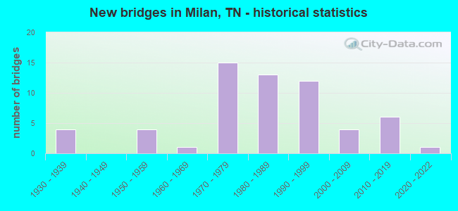
- New bridges - historical statistics
- 41930-1939
- 41950-1959
- 11960-1969
- 151970-1979
- 131980-1989
- 121990-1999
- 42000-2009
- 62010-2019
- 12020-2022
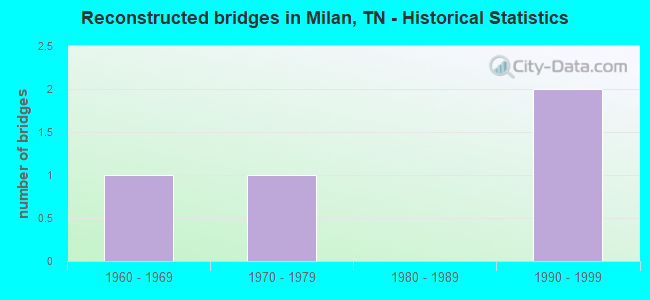
- Reconstructed bridges - Historical Statistics
- 11960-1969
- 11970-1979
- 01980-1989
- 21990-1999
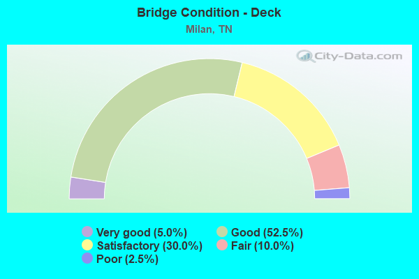
- Bridge Condition - Deck
- 5.0%Very good
- 52.5%Good
- 30.0%Satisfactory
- 10.0%Fair
- 2.5%Poor
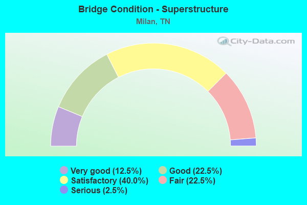
- Bridge Condition - Superstructure
- 12.5%Very good
- 22.5%Good
- 40.0%Satisfactory
- 22.5%Fair
- 2.5%Serious
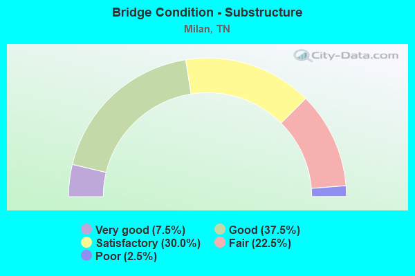
- Bridge Condition - Substructure
- 7.5%Very good
- 37.5%Good
- 30.0%Satisfactory
- 22.5%Fair
- 2.5%Poor
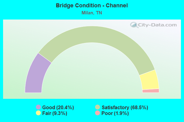
- Bridge Condition - Channel
- 20.4%Good
- 68.5%Satisfactory
- 9.3%Fair
- 1.9%Poor
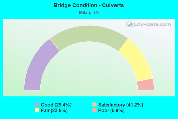
- Bridge Condition - Culverts
- 29.4%Good
- 41.2%Satisfactory
- 23.5%Fair
- 5.9%Poor
Find on map >> Show street view
Structure Number: 27SR0760017, Location: IN MILAN CITY LIMITS (Lat: 35.929367, Lng: -88.736033), Route carried "on" structure: Alternate US 70, Year Built: 2013, Status: Open, Structure Length: 0.85m (2.79ft), Average Daily Traffic: 7,446 (year 2020), Truck Traffic: 9%, Average Future Daily Traffic: 13,136 (year 2039), Design Load: HS 20, Features Intersected: BRANCH, Facility Carried by Structure: FAP 76
Minimum Vertical Clearance: 30+ m (98+ ft), Kilometerpoint: 22.410, Lanes on structure: 5, Base Highway Network: Yes (Inventory Route: 27SR0760, Subroute: 1), Owner: State Highway Agency, Approaching Roadway Width: 25.6m (84.0ft), Material/Design: Concrete continuous, Design/Construction: Culvert, Number Of Spans In Main Unit: 2, Length of Maximum Span: 3.7m (12.1ft)
Condition: Channel: Good, Culverts: Good, Operating Rating: 54.1 metric tons, Method Used To Determine Operating Rating: Assigned ratings based on Load and Resistance Factor Design (LRFD) reported by rating factor (RF) using HL93 loadings, Inventory Rating: 32.4 metric tons, Method Used To Determine Inventory Rating: Assigned ratings based on Load and Resistance Factor Design (LRFD) reported by rating factor (RF) using HL93 loadings, Structural Evaluation: Better than present minimum criteria, Waterway Adequacy: Equal to present minimum criteria, Approach Roadway Alignment: Equal to present desirable criteria, Length Of Structure Improvement: 1.51m (4.95ft), Designated Inspection Frequency: Every 24 months, Inspection Date: June 2021, Bridge Improvement Cost: $666,000, Roadway Improvement Cost: $67,000, Total Project Cost: $1,000,000 ( Estimate for 2019)
Find on map >> Show street view
Structure Number: 27SR0760019, Location: 1.9 MI.E.OF MILAN (Lat: 35.946444, Lng: -88.713889), Route carried "on" structure: Alternate US 70, Year Built: 2013, Status: Open, Structure Length: 14.63m (48.00ft), Average Daily Traffic: 6,734 (year 2020), Truck Traffic: 11%, Average Future Daily Traffic: 12,368 (year 2039), Design Load: HL 93, Features Intersected: RUTHERFORD FK.OBION RIVE, Facility Carried by Structure: FAP 76
Minimum Vertical Clearance: 30+ m (98+ ft), Kilometerpoint: 25.122, Lanes on structure: 2, Base Highway Network: Yes (Inventory Route: 27SR0760, Subroute: 1), Owner: State Highway Agency, Approaching Roadway Width: 12.8m (42.0ft), Material/Design: Prestressed concrete continuous, Design/Construction: Stringer/Multi-beam, Number Of Spans In Main Unit: 6, Length of Maximum Span: 24.5m (80.4ft), Curb-To-Curb Width: 13.0m (42.7ft), Out-to-Out Width: 13.4m (44.0ft)
Condition: Deck: Good, Superstructure: Good, Substructure: Good, Channel: Satisfactory, Operating Rating: 78.5 metric tons, Method Used To Determine Operating Rating: Load Factor (LF), Inventory Rating: 32.4 metric tons, Method Used To Determine Inventory Rating: Load Factor (LF), Structural Evaluation: Better than present minimum criteria, Deck Geometry: Somewhat better than minimum adequacy, Waterway Adequacy: Equal to present minimum criteria, Approach Roadway Alignment: Equal to present desirable criteria, Designated Inspection Frequency: Every 24 months, Inspection Date: June 2021, Deck Structure Type: Concrete Precast Panels, Wearing Surface/Protective System: Wearing Surface: Epoxy Overlay
Find on map >> Show street view
Structure Number: 27SR076002, Location: 1.9 MI.E.OF MILAN (Lat: 35.946233, Lng: -88.714217), Route carried "on" structure: Alternate US 70, Year Built: 2013, Status: Open, Structure Length: 14.63m (48.00ft), Average Daily Traffic: 6,734 (year 2020), Truck Traffic: 11%, Average Future Daily Traffic: 12,368 (year 2039), Design Load: HL 93, Features Intersected: RUTHERFORD FK.OBION RIVE, Facility Carried by Structure: FAP 76
Minimum Vertical Clearance: 30+ m (98+ ft), Kilometerpoint: 25.122, Lanes on structure: 2, Base Highway Network: Yes (Inventory Route: 27SR0760, Subroute: 1), Owner: State Highway Agency, Approaching Roadway Width: 12.8m (42.0ft), Material/Design: Prestressed concrete continuous, Design/Construction: Stringer/Multi-beam, Number Of Spans In Main Unit: 6, Length of Maximum Span: 24.5m (80.4ft), Curb-To-Curb Width: 13.0m (42.7ft), Out-to-Out Width: 13.4m (44.0ft)
Condition: Deck: Good, Superstructure: Good, Substructure: Good, Channel: Satisfactory, Operating Rating: 73.9 metric tons, Method Used To Determine Operating Rating: Load Factor (LF), Inventory Rating: 32.4 metric tons, Method Used To Determine Inventory Rating: Load Factor (LF), Structural Evaluation: Better than present minimum criteria, Deck Geometry: Somewhat better than minimum adequacy, Waterway Adequacy: Better than present minimum criteria, Approach Roadway Alignment: Equal to present desirable criteria, Designated Inspection Frequency: Every 24 months, Inspection Date: June 2021, Deck Structure Type: Concrete Precast Panels, Wearing Surface/Protective System: Wearing Surface: Epoxy Overlay
Find on map >> Show street view
Structure Number: 27SR0760021, Location: IN MILAN CITY LIMITS (Lat: 35.944633, Lng: -88.715800), Route carried "on" structure: Alternate US 70, Year Built: 2012, Status: Open, Structure Length: 1.65m (5.41ft), Average Daily Traffic: 6,734 (year 2020), Truck Traffic: 11%, Average Future Daily Traffic: 12,368 (year 2039), Design Load: HS 20, Features Intersected: OVERFLOW, Facility Carried by Structure: FAP 76
Minimum Vertical Clearance: 30+ m (98+ ft), Kilometerpoint: 24.881, Lanes on structure: 2, Base Highway Network: Yes (Inventory Route: 27SR0760, Subroute: 1), Owner: State Highway Agency, Approaching Roadway Width: 26.2m (86.0ft), Material/Design: Concrete continuous, Design/Construction: Culvert, Number Of Spans In Main Unit: 3, Length of Maximum Span: 5.5m (18.0ft)
Condition: Channel: Good, Culverts: Good, Operating Rating: 54.1 metric tons, Method Used To Determine Operating Rating: Assigned ratings based on Load and Resistance Factor Design (LRFD) reported by rating factor (RF) using HL93 loadings, Inventory Rating: 32.4 metric tons, Method Used To Determine Inventory Rating: Assigned ratings based on Load and Resistance Factor Design (LRFD) reported by rating factor (RF) using HL93 loadings, Structural Evaluation: Better than present minimum criteria, Waterway Adequacy: Equal to present minimum criteria, Approach Roadway Alignment: Equal to present desirable criteria, Designated Inspection Frequency: Every 24 months, Inspection Date: June 2021
Find on map >> Show street view
Structure Number: 27SR0770019, Location: 0.40 MI.E. JCT. FAS 8177 (Lat: 35.941917, Lng: -88.833972), Route carried "on" structure: State highway 77, Year Built: 1984, Status: Open, Structure Length: 1.67m (5.48ft), Average Daily Traffic: 2,459 (year 2020), Truck Traffic: 7%, Average Future Daily Traffic: 3,934 (year 2042), Design Load: HS 20, Features Intersected: BRANCH
Minimum Vertical Clearance: 30+ m (98+ ft), Kilometerpoint: 25.017, Lanes on structure: 2, Base Highway Network: Yes (Inventory Route: 27SR0770, Subroute: 1), Owner: State Highway Agency, Approaching Roadway Width: 10.1m (33.1ft), Skew: 1 degrees, Material/Design: Concrete continuous, Design/Construction: Culvert, Number Of Spans In Main Unit: 3, Length of Maximum Span: 5.2m (17.1ft)
Condition: Channel: Satisfactory, Culverts: Satisfactory, Operating Rating: 54.0 metric tons, Method Used To Determine Operating Rating: Field evaluation and documented engineering judgment, Inventory Rating: 32.4 metric tons, Method Used To Determine Inventory Rating: Field evaluation and documented engineering judgment, Structural Evaluation: Equal to present minimum criteria, Waterway Adequacy: Equal to present desirable criteria, Approach Roadway Alignment: Equal to present desirable criteria, Designated Inspection Frequency: Every 24 months, Inspection Date: June 2021
Find on map >> Show street view
Structure Number: 27SR1040023, Location: IN MILAN CITY LIMITS (Lat: 35.912972, Lng: -88.745278), Route carried "on" structure: State highway 104, Year Built: 1984, Status: Open, Structure Length: 3.96m (12.99ft), Average Daily Traffic: 2,510 (year 2020), Truck Traffic: 4%, Average Future Daily Traffic: 4,288 (year 2039), Design Load: HS 20, Features Intersected: WOLF CREEK
Minimum Vertical Clearance: 30+ m (98+ ft), Kilometerpoint: 24.414, Lanes on structure: 2, Base Highway Network: Yes (Inventory Route: 27SR1040, Subroute: 1), Owner: State Highway Agency, Approaching Roadway Width: 13.4m (44.0ft), Material/Design: Prestressed concrete, Design/Construction: Stringer/Multi-beam, Number Of Spans In Main Unit: 3, Length of Maximum Span: 15.2m (49.9ft), Curb-To-Curb Width: 13.4m (44.0ft), Out-to-Out Width: 14.0m (45.9ft)
Condition: Deck: Good, Superstructure: Fair, Substructure: Satisfactory, Channel: Good, Operating Rating: 54.8 metric tons, Method Used To Determine Operating Rating: Load Factor (LF), Inventory Rating: 32.4 metric tons, Method Used To Determine Inventory Rating: Load Factor (LF), Structural Evaluation: Somewhat better than minimum adequacy, Deck Geometry: Better than present minimum criteria, Waterway Adequacy: Better than present minimum criteria, Approach Roadway Alignment: Equal to present minimum criteria, Length Of Structure Improvement: 3.96m (12.99ft), Designated Inspection Frequency: Every 24 months, Inspection Date: June 2021, Bridge Improvement Cost: $832,000, Roadway Improvement Cost: $84,000, Total Project Cost: $1,249,000 ( Estimate for 2019), Deck Structure Type: Concrete Cast-file-Place, Wearing Surface/Protective System: Wearing Surface: Monolithic Concrete
Find on map >> Show street view
Structure Number: DAPAMCHOL000001, Location: HOLSTON AAP PLANT A (Lat: 36.530569, Lng: -82.550311), Route carried "on" structure: ServiceOther road , Year Built: 1950, Status: Closed, Structure Length: 1.71m (5.61ft), Average Daily Traffic: 50 (year 2016), Truck Traffic: 10%, Average Future Daily Traffic: 75 (year 2040), Features Intersected: MADD CREEK, Facility Carried by Structure: ROAD 910
Minimum Vertical Clearance: 30+ m (98+ ft), Kilometerpoint: 0.000, Lanes on structure: 2, Owner: Army, Approaching Roadway Width: 6.7m (22.0ft), Skew: 4 degrees, Material/Design: Wood or Timber, Design/Construction: Stringer/Multi-beam, Number Of Spans In Main Unit: 3, Length of Maximum Span: 5.5m (18.0ft), Curb or Sidewalk Widths: Left: 0.3m (1.0ft), Right: 0.3m (1.0ft), Curb-To-Curb Width: 7.3m (24.0ft), Out-to-Out Width: 7.9m (25.9ft)
Condition: Deck: Poor, Superstructure: Serious, Substructure: Fair, Channel: Good, Deck Geometry: Equal to present minimum criteria, Waterway Adequacy: Equal to present desirable criteria, Approach Roadway Alignment: Equal to present desirable criteria, Bridge Posting: Required (Relationship of Operating Rating to Maximum Legal Load: > 39.9% below), Length Of Structure Improvement: 2.41m (7.91ft), Designated Inspection Frequency: Every 24 months, Inspection Date: July 2020, Bridge Improvement Cost: $518,000, Roadway Improvement Cost: $58,000, Total Project Cost: $576,000 ( Estimate for 2020), Deck Structure Type: Wood or Timber, Wearing Surface/Protective System: Wearing Surface: Bituminous
Find on map >> Show street view
Structure Number: DAPAMCMAP00011A, Location: SOUTH OF ROUTE 20 (Lat: 35.860631, Lng: -88.733511), Route carried "on" structure: Other road , Year Built: 1973, Status: Open, Structure Length: 1.23m (4.04ft), Average Daily Traffic: 100 (year 2020), Truck Traffic: 10%, Average Future Daily Traffic: 400 (year 2042), Features Intersected: WEST FORK WOLF CR, Facility Carried by Structure: ROUTE 1
Minimum Vertical Clearance: 30+ m (98+ ft), Kilometerpoint: 0.000, Lanes on structure: 2, Owner: Army, Approaching Roadway Width: 5.7m (18.7ft), Skew: 4 degrees, Material/Design: Concrete, Design/Construction: Culvert, Number Of Spans In Main Unit: 3, Length of Maximum Span: 3.4m (11.2ft)
Condition: Channel: Poor, Culverts: Poor, Operating Rating: 54.5 metric tons, Method Used To Determine Operating Rating: Field evaluation and documented engineering judgment, Inventory Rating: 32.7 metric tons, Method Used To Determine Inventory Rating: Field evaluation and documented engineering judgment, Structural Evaluation: Meets minimum limits, Waterway Adequacy: Better than present minimum criteria, Approach Roadway Alignment: Equal to present desirable criteria, Length Of Structure Improvement: 1.91m (6.27ft), Designated Inspection Frequency: Every 24 months, Inspection Date: August 2020, Bridge Improvement Cost: $1,000, Roadway Improvement Cost: $1,000, Total Project Cost: $2,000 ( Estimate for 2020)
Find on map >> Show street view
Structure Number: DAPAMCMAP000B02, Location: MILAN AAP (Lat: 35.887719, Lng: -88.667311), Route carried "on" structure: Other road , Year Built: 1973, Status: Posted for load, Structure Length: 1.56m (5.12ft), Average Daily Traffic: 350 (year 2016), Truck Traffic: 40%, Average Future Daily Traffic: 1,400 (year 2042), Design Load: HS 20, Features Intersected: HALLS BRANCH CREEK, Facility Carried by Structure: ROUTE 23
Minimum Vertical Clearance: 30+ m (98+ ft), Kilometerpoint: 0.000, Lanes on structure: 2, Owner: Army, Approaching Roadway Width: 6.4m (21.0ft), Material/Design: Prestressed concrete, Design/Construction: Box Beam or Girders - Multiple, Number Of Spans In Main Unit: 2, Length of Maximum Span: 7.6m (24.9ft), Curb-To-Curb Width: 8.5m (27.9ft), Out-to-Out Width: 9.8m (32.2ft)
Condition: Deck: Satisfactory, Superstructure: Satisfactory, Substructure: Satisfactory, Channel: Fair, Operating Rating: 67.4 metric tons, Method Used To Determine Operating Rating: Load Factor (LF) rating reported by rating factor (RF) method using MS18 loading, Inventory Rating: 39.9 metric tons, Method Used To Determine Inventory Rating: Load Factor (LF) rating reported by rating factor (RF) method using MS18 loading, Structural Evaluation: Equal to present minimum criteria, Deck Geometry: Equal to present minimum criteria, Waterway Adequacy: Better than present minimum criteria, Approach Roadway Alignment: Equal to present desirable criteria, Length Of Structure Improvement: 2.20m (7.22ft), Designated Inspection Frequency: Every 24 months, Inspection Date: August 2020, Bridge Improvement Cost: $1,000, Roadway Improvement Cost: $1,000, Total Project Cost: $2,000 ( Estimate for 2020), Deck Structure Type: Concrete Cast-file-Place, Wearing Surface/Protective System: Wearing Surface: Bituminous
Find on map >> Show street view
Structure Number: DAPAMCMAP000B03, Location: MILAN AAP (Lat: 35.861000, Lng: -88.699831), Route carried "on" structure: Other road , Year Built: 1973, Status: Posted for load, Structure Length: 1.67m (5.48ft), Average Daily Traffic: 350 (year 2016), Truck Traffic: 40%, Average Future Daily Traffic: 1,400 (year 2042), Design Load: HS 20, Features Intersected: HALLS BRANCH CREEK, Facility Carried by Structure: ROUTE 24
Minimum Vertical Clearance: 30+ m (98+ ft), Kilometerpoint: 0.000, Lanes on structure: 2, Owner: Army, Approaching Roadway Width: 7.3m (24.0ft), Material/Design: Prestressed concrete, Design/Construction: Stringer/Multi-beam, Number Of Spans In Main Unit: 1, Length of Maximum Span: 16.7m (54.8ft), Curb-To-Curb Width: 7.3m (24.0ft), Out-to-Out Width: 8.4m (27.6ft)
Condition: Deck: Good, Superstructure: Very good, Substructure: Very good, Channel: Satisfactory, Operating Rating: 65.1 metric tons, Method Used To Determine Operating Rating: Load Factor (LF) rating reported by rating factor (RF) method using MS18 loading, Inventory Rating: 38.9 metric tons, Method Used To Determine Inventory Rating: Load Factor (LF) rating reported by rating factor (RF) method using MS18 loading, Structural Evaluation: Equal to present desirable criteria, Deck Geometry: Somewhat better than minimum adequacy, Waterway Adequacy: Equal to present desirable criteria, Approach Roadway Alignment: Equal to present desirable criteria, Length Of Structure Improvement: 2.36m (7.74ft), Designated Inspection Frequency: Every 24 months, Inspection Date: August 2020, Bridge Improvement Cost: $1,000, Roadway Improvement Cost: $1,000, Total Project Cost: $2,000 ( Estimate for 2020), Deck Structure Type: Concrete Cast-file-Place, Wearing Surface/Protective System: Wearing Surface: Monolithic Concrete
Find on map >> Show street view
Structure Number: DAPAMCMAP000B04, Location: MILAN AAP (Lat: 35.870139, Lng: -88.726469), Route carried "on" structure: Other road , Year Built: 1973, Status: Posted for load, Structure Length: 2.33m (7.64ft), Average Daily Traffic: 350 (year 2016), Truck Traffic: 40%, Average Future Daily Traffic: 1,400 (year 2042), Design Load: HS 20, Features Intersected: WEST WOLF CREEK, Facility Carried by Structure: ROUTE 24
Minimum Vertical Clearance: 30+ m (98+ ft), Kilometerpoint: 0.000, Lanes on structure: 2, Owner: Army, Approaching Roadway Width: 6.7m (22.0ft), Skew: 2 degrees, Material/Design: Prestressed concrete, Design/Construction: Box Beam or Girders - Multiple, Number Of Spans In Main Unit: 3, Length of Maximum Span: 7.8m (25.6ft), Curb-To-Curb Width: 8.5m (27.9ft), Out-to-Out Width: 9.8m (32.2ft)
Condition: Deck: Good, Superstructure: Good, Substructure: Satisfactory, Channel: Fair, Operating Rating: 67.4 metric tons, Method Used To Determine Operating Rating: Load Factor (LF) rating reported by rating factor (RF) method using MS18 loading, Inventory Rating: 39.9 metric tons, Method Used To Determine Inventory Rating: Load Factor (LF) rating reported by rating factor (RF) method using MS18 loading, Structural Evaluation: Equal to present minimum criteria, Deck Geometry: Equal to present minimum criteria, Waterway Adequacy: Better than present minimum criteria, Approach Roadway Alignment: Equal to present desirable criteria, Length Of Structure Improvement: 3.17m (10.40ft), Designated Inspection Frequency: Every 24 months, Inspection Date: August 2020, Bridge Improvement Cost: $1,000, Roadway Improvement Cost: $1,000, Total Project Cost: $2,000 ( Estimate for 2020), Deck Structure Type: Concrete Cast-file-Place, Wearing Surface/Protective System: Wearing Surface: Monolithic Concrete
Find on map >> Show street view
Structure Number: DAPAMCMAP000B05, Location: MILAN AAP (Lat: 35.874561, Lng: -88.721061), Route carried "on" structure: Other road , Year Built: 1973, Status: Posted for load, Structure Length: 1.56m (5.12ft), Average Daily Traffic: 350 (year 2016), Truck Traffic: 40%, Average Future Daily Traffic: 1,400 (year 2042), Design Load: HS 20, Features Intersected: EAST FORK WOLF CREEK, Facility Carried by Structure: ROUTE 75
Minimum Vertical Clearance: 30+ m (98+ ft), Kilometerpoint: 0.000, Lanes on structure: 2, Owner: Army, Approaching Roadway Width: 6.7m (22.0ft), Material/Design: Prestressed concrete, Design/Construction: Box Beam or Girders - Multiple, Number Of Spans In Main Unit: 2, Length of Maximum Span: 7.6m (24.9ft), Curb-To-Curb Width: 8.5m (27.9ft), Out-to-Out Width: 9.8m (32.2ft)
Condition: Deck: Satisfactory, Superstructure: Satisfactory, Substructure: Fair, Channel: Fair, Operating Rating: 67.4 metric tons, Method Used To Determine Operating Rating: Load Factor (LF) rating reported by rating factor (RF) method using MS18 loading, Inventory Rating: 39.9 metric tons, Method Used To Determine Inventory Rating: Load Factor (LF) rating reported by rating factor (RF) method using MS18 loading, Structural Evaluation: Somewhat better than minimum adequacy, Deck Geometry: Equal to present minimum criteria, Waterway Adequacy: Better than present minimum criteria, Approach Roadway Alignment: Equal to present desirable criteria, Length Of Structure Improvement: 2.24m (7.35ft), Designated Inspection Frequency: Every 24 months, Inspection Date: August 2020, Bridge Improvement Cost: $1,000, Roadway Improvement Cost: $1,000, Total Project Cost: $2,000 ( Estimate for 2020), Deck Structure Type: Concrete Cast-file-Place, Wearing Surface/Protective System: Wearing Surface: Bituminous
Find on map >> Show street view
Structure Number: DAPAMCMAP000B06, Location: MILAN AAP (Lat: 35.902419, Lng: -88.731219), Route carried "on" structure: Other road , Year Built: 1973, Status: Posted for load, Structure Length: 2.33m (7.64ft), Average Daily Traffic: 350 (year 2016), Truck Traffic: 40%, Average Future Daily Traffic: 1,400 (year 2042), Design Load: HS 20, Features Intersected: WOLF CREEK, Facility Carried by Structure: ROUTE 85
Minimum Vertical Clearance: 30+ m (98+ ft), Kilometerpoint: 0.000, Lanes on structure: 2, Owner: Army, Approaching Roadway Width: 6.7m (22.0ft), Material/Design: Prestressed concrete, Design/Construction: Box Beam or Girders - Multiple, Number Of Spans In Main Unit: 3, Length of Maximum Span: 7.6m (24.9ft), Curb-To-Curb Width: 8.5m (27.9ft), Out-to-Out Width: 9.8m (32.2ft)
Condition: Deck: Satisfactory, Superstructure: Satisfactory, Substructure: Satisfactory, Channel: Fair, Operating Rating: 67.4 metric tons, Method Used To Determine Operating Rating: Load Factor (LF) rating reported by rating factor (RF) method using MS18 loading, Inventory Rating: 39.9 metric tons, Method Used To Determine Inventory Rating: Load Factor (LF) rating reported by rating factor (RF) method using MS18 loading, Structural Evaluation: Equal to present minimum criteria, Deck Geometry: Equal to present minimum criteria, Waterway Adequacy: Better than present minimum criteria, Approach Roadway Alignment: Equal to present desirable criteria, Length Of Structure Improvement: 3.12m (10.24ft), Designated Inspection Frequency: Every 24 months, Inspection Date: August 2020, Bridge Improvement Cost: $1,000, Roadway Improvement Cost: $1,000, Total Project Cost: $2,000 ( Estimate for 2020), Deck Structure Type: Concrete Cast-file-Place, Wearing Surface/Protective System: Wearing Surface: Monolithic Concrete
Find on map >> Show street view
Structure Number: DAPAMCMAP000B08, Location: MILAN AAP (Lat: 35.848361, Lng: -88.715811), Route carried "on" structure: Other road , Year Built: 1973, Status: Posted for load, Structure Length: 2.11m (6.92ft), Average Daily Traffic: 100 (year 2016), Truck Traffic: 60%, Average Future Daily Traffic: 400 (year 2042), Design Load: HS 20, Features Intersected: CROSSING DRY CREEK, Facility Carried by Structure: ROUTE 2
Minimum Vertical Clearance: 30+ m (98+ ft), Kilometerpoint: 0.000, Lanes on structure: 2, Owner: Army, Approaching Roadway Width: 7.6m (24.9ft), Material/Design: Prestressed concrete, Design/Construction: Box Beam or Girders - Multiple, Number Of Spans In Main Unit: 2, Length of Maximum Span: 10.4m (34.1ft), Curb-To-Curb Width: 8.5m (27.9ft), Out-to-Out Width: 9.8m (32.2ft)
Condition: Deck: Satisfactory, Superstructure: Satisfactory, Substructure: Satisfactory, Channel: Satisfactory, Operating Rating: 65.1 metric tons, Method Used To Determine Operating Rating: Load Factor (LF) rating reported by rating factor (RF) method using MS18 loading, Inventory Rating: 38.9 metric tons, Method Used To Determine Inventory Rating: Load Factor (LF) rating reported by rating factor (RF) method using MS18 loading, Structural Evaluation: Equal to present minimum criteria, Deck Geometry: Better than present minimum criteria, Waterway Adequacy: Equal to present desirable criteria, Approach Roadway Alignment: Equal to present desirable criteria, Length Of Structure Improvement: 2.85m (9.35ft), Designated Inspection Frequency: Every 24 months, Inspection Date: August 2020, Bridge Improvement Cost: $1,000, Roadway Improvement Cost: $1,000, Total Project Cost: $2,000 ( Estimate for 2020), Deck Structure Type: Concrete Cast-file-Place, Wearing Surface/Protective System: Wearing Surface: Bituminous
Find on map >> Show street view
Structure Number: DAPAMCMAP000B09, Location: MILAN AAP (Lat: 35.859361, Lng: -88.721169), Route carried "on" structure: Other road , Year Built: 1973, Status: Posted for load, Structure Length: 1.56m (5.12ft), Average Daily Traffic: 100 (year 2016), Truck Traffic: 60%, Average Future Daily Traffic: 400 (year 2042), Design Load: HS 20, Features Intersected: CROSSING DRY CREEK, Facility Carried by Structure: ROUTE A8
Minimum Vertical Clearance: 30+ m (98+ ft), Kilometerpoint: 0.000, Lanes on structure: 2, Owner: Army, Approaching Roadway Width: 6.1m (20.0ft), Material/Design: Prestressed concrete, Design/Construction: Box Beam or Girders - Multiple, Number Of Spans In Main Unit: 2, Length of Maximum Span: 7.6m (24.9ft), Curb-To-Curb Width: 8.5m (27.9ft), Out-to-Out Width: 9.8m (32.2ft)
Condition: Deck: Good, Superstructure: Good, Substructure: Satisfactory, Channel: Satisfactory, Operating Rating: 67.4 metric tons, Method Used To Determine Operating Rating: Load Factor (LF) rating reported by rating factor (RF) method using MS18 loading, Inventory Rating: 39.9 metric tons, Method Used To Determine Inventory Rating: Load Factor (LF) rating reported by rating factor (RF) method using MS18 loading, Structural Evaluation: Equal to present minimum criteria, Deck Geometry: Better than present minimum criteria, Waterway Adequacy: Equal to present desirable criteria, Approach Roadway Alignment: Equal to present desirable criteria, Length Of Structure Improvement: 2.20m (7.22ft), Designated Inspection Frequency: Every 24 months, Inspection Date: August 2020, Bridge Improvement Cost: $1,000, Roadway Improvement Cost: $1,000, Total Project Cost: $2,000 ( Estimate for 2020), Deck Structure Type: Concrete Cast-file-Place, Wearing Surface/Protective System: Wearing Surface: Bituminous
Find on map >> Show street view
Structure Number: DAPAMCMAP000B1, Location: MILAN AAP (Lat: 35.860361, Lng: -88.700111), Route carried "on" structure: Other road , Year Built: 1973, Status: Posted for load, Structure Length: 1.67m (5.48ft), Average Daily Traffic: 100 (year 2016), Truck Traffic: 60%, Average Future Daily Traffic: 400 (year 2042), Design Load: HS 20, Features Intersected: EAST WOLF CREEK, Facility Carried by Structure: PATRO ROAD NORTH
Minimum Vertical Clearance: 30+ m (98+ ft), Kilometerpoint: 0.000, Lanes on structure: 2, Owner: Army, Approaching Roadway Width: 7.3m (24.0ft), Material/Design: Prestressed concrete, Design/Construction: Stringer/Multi-beam, Number Of Spans In Main Unit: 1, Length of Maximum Span: 15.7m (51.5ft), Curb-To-Curb Width: 7.3m (24.0ft), Out-to-Out Width: 8.4m (27.6ft)
Condition: Deck: Good, Superstructure: Very good, Substructure: Good, Channel: Good, Operating Rating: 65.1 metric tons, Method Used To Determine Operating Rating: Load Factor (LF) rating reported by rating factor (RF) method using MS18 loading, Inventory Rating: 38.9 metric tons, Method Used To Determine Inventory Rating: Load Factor (LF) rating reported by rating factor (RF) method using MS18 loading, Structural Evaluation: Better than present minimum criteria, Deck Geometry: Equal to present minimum criteria, Waterway Adequacy: Equal to present desirable criteria, Approach Roadway Alignment: Equal to present minimum criteria, Length Of Structure Improvement: 2.24m (7.35ft), Designated Inspection Frequency: Every 24 months, Inspection Date: August 2020, Bridge Improvement Cost: $1,000, Roadway Improvement Cost: $1,000, Total Project Cost: $2,000 ( Estimate for 2020), Deck Structure Type: Concrete Cast-file-Place, Wearing Surface/Protective System: Wearing Surface: Monolithic Concrete
Find on map >> Show street view
Structure Number: 9SR1040017, Location: MILAN ARSENAL (Lat: 35.910389, Lng: -88.692772), Route carried "under" structure: State highway 104, Year Built: 1985, Structure Length: 0. m, Average Daily Traffic: 1,348 (year 2020), Truck Traffic: 5%, Features Intersected: BRANCH
Minimum Vertical Clearance: 5.38m (17.65ft), Kilometerpoint: 0.660, Lanes under structure: 2, Material/Design: Steel, Design/Construction: Truss - Deck, Length of Maximum Span: 12.0m (39.4ft)
Find on map >> Show street view
Structure Number: 27015880007, Location: .7 MI NW JCT SR43&SR104 (Lat: 35.921111, Lng: -88.761222), Route carried "under" structure: City street 1588, Year Built: 1955, Structure Length: 0. m, Average Daily Traffic: 677 (year 2020), Truck Traffic: 3%, Features Intersected: ICG RAILROAD
Minimum Vertical Clearance: 2.79m (9.15ft), Kilometerpoint: 8.256, Lanes under structure: 2, Material/Design: Steel, Design/Construction: Stringer/Multi-beam, Length of Maximum Span: 4.0m (13.1ft)
Find on map >> Show street view
Structure Number: 27SR0760015, Location: IN MILAN (Lat: 35.926750, Lng: -88.739333), Route carried "under" structure: Alternate US 70, Year Built: 2013, Structure Length: 0. m, Average Daily Traffic: 7,446 (year 2020), Truck Traffic: 9%, Features Intersected: CSX RR / SR 76, Facility Carried by Structure: CSX RR
Minimum Vertical Clearance: 5.00m (16.40ft), Kilometerpoint: 22.008, Lanes under structure: 2, Material/Design: Steel, Design/Construction: Stringer/Multi-beam, Length of Maximum Span: 36.0m (118.1ft)