Bridge Statistics for Milan, Michigan (MI)
Condition, Traffic, Stress, Structural Evaluation, Project Costs
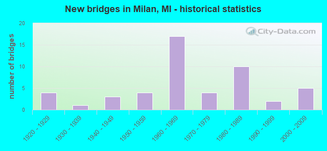
- New bridges - historical statistics
- 41920-1929
- 11930-1939
- 31940-1949
- 41950-1959
- 171960-1969
- 41970-1979
- 101980-1989
- 21990-1999
- 52000-2009

- Reconstructed bridges - Historical Statistics
- 11960-1969
- 01970-1979
- 31980-1989
- 11990-1999
- 22000-2009


- Bridge Condition - Deck
- 6.5%Excellent
- 6.5%Very good
- 16.1%Good
- 38.7%Satisfactory
- 22.6%Fair
- 9.7%Poor

- Bridge Condition - Superstructure
- 6.3%Excellent
- 6.3%Very good
- 18.8%Good
- 31.3%Satisfactory
- 25.0%Fair
- 9.4%Poor
- 3.1%Serious

- Bridge Condition - Substructure
- 3.1%Excellent
- 6.3%Very good
- 21.9%Good
- 40.6%Satisfactory
- 15.6%Fair
- 12.5%Poor

- Bridge Condition - Channel
- 9.7%Very good
- 9.7%Good
- 25.8%Satisfactory
- 38.7%Fair
- 12.9%Poor
- 3.2%Serious

- Bridge Condition - Culverts
- 50.0%Good
- 37.5%Satisfactory
- 12.5%Fair
Find on map >> Show street view
Structure Number: 474, Location: 0.6 MI N OF TWINING RD (Lat: 44.119453, Lng: -83.706400), Route carried "on" structure: County highway , Year Built: 1985, Status: Open, Structure Length: 0.67m (2.20ft), Average Daily Traffic: 99 (year 1998), Average Future Daily Traffic: 70 (year 1977), Design Load: HS 20+Mod, Features Intersected: CEDAR CREEK, Facility Carried by Structure: SANTIAGO ROAD
Minimum Vertical Clearance: 30.48m (100.00ft), Kilometerpoint: 3.888, Lanes on structure: 2, Owner: County Highway Agency, Approaching Roadway Width: 8.2m (26.9ft), Skew: 2 degrees, Material/Design: Concrete, Design/Construction: Culvert, Number Of Spans In Main Unit: 1, Length of Maximum Span: 6.1m (20.0ft), Curb-To-Curb Width: 6.7m (22.0ft), Out-to-Out Width: 12.2m (40.0ft)
Condition: Channel: Satisfactory, Culverts: Satisfactory, Operating Rating: 54.5 metric tons, Method Used To Determine Operating Rating: Field evaluation and documented engineering judgment, Inventory Rating: 32.7 metric tons, Method Used To Determine Inventory Rating: Field evaluation and documented engineering judgment, Structural Evaluation: Equal to present minimum criteria, Deck Geometry: Somewhat better than minimum adequacy, Waterway Adequacy: Equal to present desirable criteria, Approach Roadway Alignment: Better than present minimum criteria, Designated Inspection Frequency: Every 24 months, Inspection Date: August 2020, Deck Structure Type: Concrete Cast-file-Place, Wearing Surface/Protective System: Wearing Surface: Gravel, Deck Protection: Epoxy Coated Reinforcing
Find on map >> Show street view
Structure Number: 7081, Location: IN MILAN (Lat: 42.075011, Lng: -83.670575), Route carried "on" structure: US 23, Year Built: 1961, Status: Open, Structure Length: 3.65m (11.98ft), Average Daily Traffic: 17,569 (year 2007), Truck Traffic: 17%, Average Future Daily Traffic: 19,569 (year 2018), Design Load: HS 20, Features Intersected: SALINE RIVER
Minimum Vertical Clearance: 30.48m (100.00ft), Kilometerpoint: 39.974, Lanes on structure: 2, Base Highway Network: Yes (Inventory Route: 122, Subroute: 5), Owner: State Highway Agency, Approaching Roadway Width: 12.8m (42.0ft), Skew: 10 degrees, Material/Design: Steel, Design/Construction: Stringer/Multi-beam, Number Of Spans In Main Unit: 3, Length of Maximum Span: 15.2m (49.9ft), Curb-To-Curb Width: 13.1m (43.0ft), Out-to-Out Width: 14.5m (47.6ft)
Condition: Deck: Satisfactory, Superstructure: Fair, Substructure: Satisfactory, Channel: Satisfactory, Operating Rating: 87.5 metric tons, Method Used To Determine Operating Rating: Load Factor (LF) rating reported by rating factor (RF) method using MS18 loading, Inventory Rating: 44.1 metric tons, Method Used To Determine Inventory Rating: Load Factor (LF) rating reported by rating factor (RF) method using MS18 loading, Structural Evaluation: Somewhat better than minimum adequacy, Deck Geometry: Superior to present desirable criteria, Waterway Adequacy: Equal to present desirable criteria, Approach Roadway Alignment: Equal to present desirable criteria, Designated Inspection Frequency: Every 24 months, Inspection Date: May 2021, Deck Structure Type: Concrete Cast-file-Place, Wearing Surface/Protective System: Wearing Surface: Latex Concrete
Find on map >> Show street view
Structure Number: 7082, Location: IN MILAN (Lat: 42.075019, Lng: -83.670911), Route carried "on" structure: US 23, Year Built: 1948, Status: Open, Structure Length: 3.65m (11.98ft), Average Daily Traffic: 17,569 (year 2007), Truck Traffic: 17%, Average Future Daily Traffic: 19,569 (year 2018), Design Load: HS 20, Features Intersected: SALINE RIVER
Minimum Vertical Clearance: 30.48m (100.00ft), Kilometerpoint: 40.056, Lanes on structure: 2, Base Highway Network: Yes (Inventory Route: 122, Subroute: 4), Owner: State Highway Agency, Approaching Roadway Width: 12.8m (42.0ft), Skew: 10 degrees, Material/Design: Steel, Design/Construction: Stringer/Multi-beam, Number Of Spans In Main Unit: 3, Length of Maximum Span: 15.2m (49.9ft), Curb-To-Curb Width: 13.1m (43.0ft), Out-to-Out Width: 14.5m (47.6ft)
Condition: Deck: Satisfactory, Superstructure: Fair, Substructure: Satisfactory, Channel: Fair, Operating Rating: 87.5 metric tons, Method Used To Determine Operating Rating: Load Factor (LF) rating reported by rating factor (RF) method using MS18 loading, Inventory Rating: 44.1 metric tons, Method Used To Determine Inventory Rating: Load Factor (LF) rating reported by rating factor (RF) method using MS18 loading, Structural Evaluation: Somewhat better than minimum adequacy, Deck Geometry: Superior to present desirable criteria, Waterway Adequacy: Equal to present minimum criteria, Approach Roadway Alignment: Equal to present desirable criteria, Designated Inspection Frequency: Every 24 months, Inspection Date: May 2021, Deck Structure Type: Concrete Cast-file-Place, Wearing Surface/Protective System: Wearing Surface: Latex Concrete
Find on map >> Show street view
Structure Number: 7084, Location: 5.2 MI N OF M-50 (Lat: 42.033475, Lng: -83.676392), Route carried "on" structure: County highway , Year Built: 1961, Status: Open, Structure Length: 7.40m (24.28ft), Average Daily Traffic: 2,250 (year 2000), Truck Traffic: 6%, Average Future Daily Traffic: 2,700 (year 2020), Design Load: HS 20, Features Intersected: US-23, Facility Carried by Structure: CONE RD
Minimum Vertical Clearance: 30.48m (100.00ft), Kilometerpoint: 7.957, Lanes on structure: 2, Lanes under structure: 4, Owner: State Highway Agency, Approaching Roadway Width: 9.7m (31.8ft), Skew: 3 degrees, Material/Design: Steel, Design/Construction: Stringer/Multi-beam, Number Of Spans In Main Unit: 4, Length of Maximum Span: 25.0m (82.0ft), Curb-To-Curb Width: 9.3m (30.5ft), Out-to-Out Width: 10.0m (32.8ft)
Condition: Deck: Fair, Superstructure: Satisfactory, Substructure: Satisfactory, Operating Rating: 63.8 metric tons, Method Used To Determine Operating Rating: Load Factor (LF) rating reported by rating factor (RF) method using MS18 loading, Inventory Rating: 38.2 metric tons, Method Used To Determine Inventory Rating: Load Factor (LF) rating reported by rating factor (RF) method using MS18 loading, Structural Evaluation: Equal to present minimum criteria, Deck Geometry: Meets minimum limits, Underclear: Somewhat better than minimum adequacy, Approach Roadway Alignment: Equal to present desirable criteria, Designated Inspection Frequency: Every 24 months, Inspection Date: May 2021, Deck Structure Type: Concrete Cast-file-Place, Wearing Surface/Protective System: Wearing Surface: Latex Concrete
Find on map >> Show street view
Structure Number: 7085, Location: 1.6 MI S OF WASHTENAW COL (Lat: 42.062603, Lng: -83.670158), Route carried "on" structure: County highway , Year Built: 1961, Status: Open, Structure Length: 6.34m (20.80ft), Average Daily Traffic: 957 (year 1984), Truck Traffic: 3%, Average Future Daily Traffic: 957 (year 1977), Design Load: H 15, Features Intersected: US-23, Facility Carried by Structure: SHERMAN RD
Minimum Vertical Clearance: 30.48m (100.00ft), Kilometerpoint: 3.171, Lanes on structure: 2, Lanes under structure: 4, Owner: State Highway Agency, Approaching Roadway Width: 9.7m (31.8ft), Material/Design: Steel, Design/Construction: Stringer/Multi-beam, Number Of Spans In Main Unit: 4, Length of Maximum Span: 21.6m (70.9ft), Curb-To-Curb Width: 8.7m (28.5ft), Out-to-Out Width: 9.4m (30.8ft)
Condition: Deck: Satisfactory, Superstructure: Fair, Substructure: Satisfactory, Operating Rating: 50.9 metric tons, Method Used To Determine Operating Rating: Load Factor (LF) rating reported by rating factor (RF) method using MS18 loading, Inventory Rating: 30.5 metric tons, Method Used To Determine Inventory Rating: Load Factor (LF) rating reported by rating factor (RF) method using MS18 loading, Structural Evaluation: Somewhat better than minimum adequacy, Deck Geometry: Somewhat better than minimum adequacy, Underclear: Somewhat better than minimum adequacy, Approach Roadway Alignment: Equal to present desirable criteria, Designated Inspection Frequency: Every 24 months, Inspection Date: May 2021, Deck Structure Type: Concrete Cast-file-Place, Wearing Surface/Protective System: Wearing Surface: Monolithic Concrete
Find on map >> Show street view
Structure Number: 7086, Location: 0.4 MI S OF WASHTENAW COL (Lat: 42.079283, Lng: -83.670700), Route carried "on" structure: County highway 5835, Year Built: 1961, Status: Open, Structure Length: 8.96m (29.40ft), Average Daily Traffic: 770 (year 1974), Average Future Daily Traffic: 770 (year 1977), Design Load: HS 20, Features Intersected: US-23, Facility Carried by Structure: PLANK RD
Minimum Vertical Clearance: 30.48m (100.00ft), Kilometerpoint: 1.045, Lanes on structure: 2, Lanes under structure: 6, Owner: State Highway Agency, Approaching Roadway Width: 10.3m (33.8ft), Skew: 4 degrees, Material/Design: Steel, Design/Construction: Stringer/Multi-beam, Number Of Spans In Main Unit: 4, Length of Maximum Span: 32.0m (105.0ft), Curb-To-Curb Width: 9.9m (32.5ft), Out-to-Out Width: 10.6m (34.8ft)
Condition: Deck: Fair, Superstructure: Poor, Substructure: Fair, Operating Rating: 61.9 metric tons, Method Used To Determine Operating Rating: Load Factor (LF) rating reported by rating factor (RF) method using MS18 loading, Inventory Rating: 36.9 metric tons, Method Used To Determine Inventory Rating: Load Factor (LF) rating reported by rating factor (RF) method using MS18 loading, Structural Evaluation: Meets minimum limits, Deck Geometry: Equal to present minimum criteria, Underclear: Meets minimum limits, Approach Roadway Alignment: Equal to present minimum criteria, Designated Inspection Frequency: Every 12 months, Inspection Date: May 2021, Bridge Improvement Cost: $240,000, Deck Structure Type: Concrete Cast-file-Place, Wearing Surface/Protective System: Wearing Surface: Latex Concrete
Find on map >> Show street view
Structure Number: 7087, Location: @ WASHTENAW CO LINE (Lat: 42.084325, Lng: -83.671778), Route carried "on" structure: City street 8102, Year Built: 1950, Status: Open, Structure Length: 4.36m (14.30ft), Average Daily Traffic: 881 (year 1997), Truck Traffic: 3%, Average Future Daily Traffic: 430 (year 1977), Design Load: HS 20, Features Intersected: US-23, Facility Carried by Structure: MILAN-OAKVILLE RD
Minimum Vertical Clearance: 30.48m (100.00ft), Kilometerpoint: 0.797, Lanes on structure: 2, Lanes under structure: 4, Owner: State Highway Agency, Approaching Roadway Width: 10.3m (33.8ft), Skew: 2 degrees, Material/Design: Steel, Design/Construction: Stringer/Multi-beam, Number Of Spans In Main Unit: 3, Length of Maximum Span: 24.3m (79.7ft), Curb or Sidewalk Widths: Left: 0.4m (1.3ft), Right: 0.9m (3.0ft), Curb-To-Curb Width: 8.5m (27.9ft), Out-to-Out Width: 10.4m (34.1ft)
Condition: Deck: Satisfactory, Superstructure: Satisfactory, Substructure: Satisfactory, Operating Rating: 75.8 metric tons, Method Used To Determine Operating Rating: Load Factor (LF) rating reported by rating factor (RF) method using MS18 loading, Inventory Rating: 45.4 metric tons, Method Used To Determine Inventory Rating: Load Factor (LF) rating reported by rating factor (RF) method using MS18 loading, Structural Evaluation: Equal to present minimum criteria, Deck Geometry: Somewhat better than minimum adequacy, Underclear: Somewhat better than minimum adequacy, Approach Roadway Alignment: Equal to present desirable criteria, Length Of Structure Improvement: 4.36m (14.30ft), Designated Inspection Frequency: Every 24 months, Inspection Date: May 2021, Bridge Improvement Cost: $163,000, Roadway Improvement Cost: $5,000, Total Project Cost: $63,000, Deck Structure Type: Concrete Cast-file-Place, Wearing Surface/Protective System: Wearing Surface: Monolithic Concrete
Find on map >> Show street view
Structure Number: 7251, Location: 3.95 MI N OF M 50 (Lat: 42.024117, Lng: -83.733333), Route carried "on" structure: County highway 5809, Year Built: 1997, Status: Open, Structure Length: 1.22m (4.00ft), Average Daily Traffic: 420 (year 2015), Truck Traffic: 1%, Average Future Daily Traffic: 483 (year 2036), Design Load: HS 20, Features Intersected: BEAR SWAMP CREEK, Facility Carried by Structure: DENNISON RD
Minimum Vertical Clearance: 30.48m (100.00ft), Kilometerpoint: 12.822, Lanes on structure: 2, Owner: County Highway Agency, Approaching Roadway Width: 9.8m (32.2ft), Material/Design: Prestressed concrete, Design/Construction: Box Beam or Girders - Multiple, Number Of Spans In Main Unit: 1, Length of Maximum Span: 11.8m (38.7ft), Curb-To-Curb Width: 9.8m (32.2ft), Out-to-Out Width: 10.5m (34.4ft)
Condition: Deck: Fair, Superstructure: Satisfactory, Substructure: Very good, Channel: Satisfactory, Operating Rating: 79.1 metric tons, Method Used To Determine Operating Rating: Load Factor (LF) rating reported by rating factor (RF) method using MS18 loading, Inventory Rating: 47.3 metric tons, Method Used To Determine Inventory Rating: Load Factor (LF) rating reported by rating factor (RF) method using MS18 loading, Structural Evaluation: Equal to present minimum criteria, Deck Geometry: Equal to present minimum criteria, Waterway Adequacy: Equal to present minimum criteria, Approach Roadway Alignment: Equal to present desirable criteria, Designated Inspection Frequency: Every 24 months, Inspection Date: March 2022, Deck Structure Type: Concrete Cast-file-Place, Wearing Surface/Protective System: Wearing Surface: Monolithic Concrete, Deck Protection: Epoxy Coated Reinforcing
Find on map >> Show street view
Structure Number: 7258, Location: 3.7 MI E OF LENAWEE CO LI (Lat: 42.033022, Lng: -83.703053), Route carried "on" structure: County highway , Year Built: 2001, Status: Open, Structure Length: 0.72m (2.36ft), Average Daily Traffic: 790 (year 2016), Truck Traffic: 14%, Average Future Daily Traffic: 909 (year 2036), Design Load: HS 20+Mod, Features Intersected: MILAN CENTER DRAIN, Facility Carried by Structure: CONE RD
Minimum Vertical Clearance: 30.48m (100.00ft), Kilometerpoint: 5.749, Lanes on structure: 2, Owner: County Highway Agency, Approaching Roadway Width: 7.9m (25.9ft), Skew: 2 degrees, Material/Design: Concrete, Design/Construction: Culvert, Number Of Spans In Main Unit: 1, Length of Maximum Span: 6.6m (21.7ft), Curb-To-Curb Width: 7.9m (25.9ft), Out-to-Out Width: 33.0m (108.3ft)
Condition: Channel: Good, Culverts: Good, Operating Rating: 52.2 metric tons, Method Used To Determine Operating Rating: Load Factor (LF) rating reported by rating factor (RF) method using MS18 loading, Inventory Rating: 31.1 metric tons, Method Used To Determine Inventory Rating: Load Factor (LF) rating reported by rating factor (RF) method using MS18 loading, Structural Evaluation: Better than present minimum criteria, Deck Geometry: Somewhat better than minimum adequacy, Waterway Adequacy: Better than present minimum criteria, Approach Roadway Alignment: Equal to present minimum criteria, Designated Inspection Frequency: Every 24 months, Inspection Date: March 2022, Wearing Surface/Protective System: Wearing Surface: Bituminous
Find on map >> Show street view
Structure Number: 7259, Location: 4.65 MI E OF LENAWEE CO (Lat: 42.033336, Lng: -83.685478), Route carried "on" structure: County highway , Year Built: 2004, Status: Open, Structure Length: 0.80m (2.62ft), Average Daily Traffic: 890 (year 2016), Truck Traffic: 2%, Average Future Daily Traffic: 1,024 (year 2036), Design Load: HS 20, Features Intersected: WARREN LEWIS DRAIN, Facility Carried by Structure: CONE RD
Minimum Vertical Clearance: 30.48m (100.00ft), Kilometerpoint: 7.205, Lanes on structure: 2, Owner: County Highway Agency, Approaching Roadway Width: 7.3m (24.0ft), Skew: 4 degrees, Material/Design: Concrete, Design/Construction: Culvert, Number Of Spans In Main Unit: 1, Length of Maximum Span: 6.7m (22.0ft), Out-to-Out Width: 6.6m (21.7ft)
Condition: Channel: Satisfactory, Culverts: Good, Operating Rating: 60.9 metric tons, Method Used To Determine Operating Rating: Load Factor (LF) rating reported by rating factor (RF) method using MS18 loading, Inventory Rating: 36.6 metric tons, Method Used To Determine Inventory Rating: Load Factor (LF) rating reported by rating factor (RF) method using MS18 loading, Structural Evaluation: Better than present minimum criteria, Waterway Adequacy: Equal to present desirable criteria, Approach Roadway Alignment: Equal to present minimum criteria, Designated Inspection Frequency: Every 24 months, Inspection Date: October 2020, Wearing Surface/Protective System: Wearing Surface: Bituminous, Membrane: Preformed Fabric
Find on map >> Show street view
Structure Number: 7261, Location: .25 MI W OF US 23 (Lat: 42.033397, Lng: -83.681572), Route carried "on" structure: County highway 5817, Year Built: 1950, Year Reconstructed: 2021, Status: Open, Structure Length: 1.28m (4.20ft), Average Daily Traffic: 1,770 (year 2020), Truck Traffic: 19%, Average Future Daily Traffic: 1,956 (year 2040), Design Load: Greater than HL93, Features Intersected: NORTH MACON CREEK, Facility Carried by Structure: CONE RD
Minimum Vertical Clearance: 30.48m (100.00ft), Kilometerpoint: 7.529, Lanes on structure: 2, Owner: County Highway Agency, Approaching Roadway Width: 7.3m (24.0ft), Material/Design: Steel, Design/Construction: Box Beam or Girders - Single/Spread, Number Of Spans In Main Unit: 1, Length of Maximum Span: 11.4m (37.4ft), Curb-To-Curb Width: 9.8m (32.2ft), Out-to-Out Width: 10.7m (35.1ft)
Condition: Deck: Excellent, Superstructure: Excellent, Substructure: Satisfactory, Channel: Good, Operating Rating: 97.2 metric tons, Method Used To Determine Operating Rating: Load and Resistance Factor Rating (LRFR) rating reported by rating factor(RF) method using HL-93 loadings, Inventory Rating: 95.6 metric tons, Method Used To Determine Inventory Rating: Load and Resistance Factor Rating (LRFR) rating reported by rating factor(RF) method using HL-93 loadings, Structural Evaluation: Equal to present minimum criteria, Deck Geometry: Somewhat better than minimum adequacy, Waterway Adequacy: Equal to present desirable criteria, Approach Roadway Alignment: Equal to present minimum criteria, Designated Inspection Frequency: Every 24 months, Inspection Date: September 2021, Deck Structure Type: Concrete Cast-file-Place, Wearing Surface/Protective System: Wearing Surface: Monolithic Concrete, Deck Protection: Epoxy Coated Reinforcing
Find on map >> Show street view
Structure Number: 7262, Location: 0.3 MI S OF REDMAN RD (Lat: 42.071197, Lng: -83.735339), Route carried "on" structure: County highway 5809, Year Built: 1929, Status: Posted for load, Structure Length: 0.94m (3.08ft), Average Daily Traffic: 1,250 (year 2019), Truck Traffic: 8%, Average Future Daily Traffic: 1,437 (year 2039), Features Intersected: NORTH MACON CREEK, Facility Carried by Structure: DENNISON ROAD
Minimum Vertical Clearance: 30.48m (100.00ft), Kilometerpoint: 18.053, Lanes on structure: 2, Owner: County Highway Agency, Approaching Roadway Width: 8.5m (27.9ft), Material/Design: Concrete, Design/Construction: Tee Beam, Number Of Spans In Main Unit: 1, Length of Maximum Span: 8.8m (28.9ft), Curb-To-Curb Width: 6.7m (22.0ft), Out-to-Out Width: 8.6m (28.2ft)
Condition: Deck: Poor, Superstructure: Serious, Substructure: Poor, Channel: Fair, Operating Rating: 39.5 metric tons, Method Used To Determine Operating Rating: Load Factor (LF) rating reported by rating factor (RF) method using MS18 loading, Inventory Rating: 23.7 metric tons, Method Used To Determine Inventory Rating: Load Factor (LF) rating reported by rating factor (RF) method using MS18 loading, Structural Evaluation: High priority of corrective action, Deck Geometry: High priority of corrective action, Waterway Adequacy: Equal to present minimum criteria, Approach Roadway Alignment: High priority of replacement, Bridge Posting: Required (Relationship of Operating Rating to Maximum Legal Load: 20.0 - 29.9% below), Designated Inspection Frequency: Every 12 months, Inspection Date: October 2021, Deck Structure Type: Concrete Cast-file-Place, Wearing Surface/Protective System: Wearing Surface: Bituminous
Find on map >> Show street view
Structure Number: 7263, Location: .65 MI NO OF CONE RD (Lat: 42.042656, Lng: -83.684525), Route carried "on" structure: County highway 5817, Year Built: 1948, Year Reconstructed: 2014, Status: Open, Structure Length: 1.28m (4.20ft), Average Daily Traffic: 1,330 (year 2018), Truck Traffic: 9%, Average Future Daily Traffic: 1,529 (year 2038), Design Load: HL 93, Features Intersected: NORTH MACON CREEK, Facility Carried by Structure: WABASH RD
Minimum Vertical Clearance: 30.48m (100.00ft), Kilometerpoint: 1.033, Lanes on structure: 2, Owner: County Highway Agency, Approaching Roadway Width: 7.9m (25.9ft), Skew: 3 degrees, Material/Design: Prestressed concrete, Design/Construction: Box Beam or Girders - Multiple, Number Of Spans In Main Unit: 1, Length of Maximum Span: 12.3m (40.4ft), Curb-To-Curb Width: 10.1m (33.1ft), Out-to-Out Width: 10.6m (34.8ft)
Condition: Deck: Very good, Superstructure: Very good, Substructure: Good, Channel: Fair, Operating Rating: 82.3 metric tons, Method Used To Determine Operating Rating: Load and Resistance Factor Rating (LRFR) rating reported by rating factor(RF) method using HL-93 loadings, Inventory Rating: 63.5 metric tons, Method Used To Determine Inventory Rating: Load and Resistance Factor Rating (LRFR) rating reported by rating factor(RF) method using HL-93 loadings, Structural Evaluation: Better than present minimum criteria, Deck Geometry: Somewhat better than minimum adequacy, Waterway Adequacy: Equal to present minimum criteria, Approach Roadway Alignment: Better than present minimum criteria, Designated Inspection Frequency: Every 24 months, Inspection Date: October 2020, Deck Structure Type: Concrete Cast-file-Place, Wearing Surface/Protective System: Wearing Surface: Monolithic Concrete, Deck Protection: Epoxy Coated Reinforcing
Find on map >> Show street view
Structure Number: 7371, Location: 0.1 MI E OF WELLS ROAD (Lat: 42.062883, Lng: -83.653758), Route carried "on" structure: County highway , Year Built: 1981, Status: Posted for load, Structure Length: 3.66m (12.01ft), Average Daily Traffic: 500 (year 2003), Truck Traffic: 3%, Average Future Daily Traffic: 620 (year 2023), Design Load: HS 20, Features Intersected: SALINE RIVER, Facility Carried by Structure: SHERMAN ROAD
Minimum Vertical Clearance: 30.48m (100.00ft), Kilometerpoint: 4.529, Lanes on structure: 2, Owner: County Highway Agency, Approaching Roadway Width: 7.3m (24.0ft), Skew: 3 degrees, Material/Design: Prestressed concrete, Design/Construction: Box Beam or Girders - Multiple, Number Of Spans In Main Unit: 3, Length of Maximum Span: 11.7m (38.4ft), Curb-To-Curb Width: 9.5m (31.2ft), Out-to-Out Width: 9.5m (31.2ft)
Condition: Deck: Satisfactory, Superstructure: Satisfactory, Substructure: Good, Channel: Fair, Operating Rating: 47.6 metric tons, Method Used To Determine Operating Rating: Load Factor (LF) rating reported by rating factor (RF) method using MS18 loading, Inventory Rating: 28.5 metric tons, Method Used To Determine Inventory Rating: Load Factor (LF) rating reported by rating factor (RF) method using MS18 loading, Structural Evaluation: Equal to present minimum criteria, Deck Geometry: Equal to present minimum criteria, Waterway Adequacy: Equal to present minimum criteria, Approach Roadway Alignment: Equal to present desirable criteria, Bridge Posting: Required (Relationship of Operating Rating to Maximum Legal Load: 0.1 - 9.9% below), Designated Inspection Frequency: Every 24 months, Inspection Date: November 2020, Deck Structure Type: Concrete Precast Panels, Wearing Surface/Protective System: Wearing Surface: Bituminous, Membrane: Preformed Fabric
Find on map >> Show street view
Structure Number: 7372, Location: 0.2 MI W OF PLANK ROAD (Lat: 42.037864, Lng: -83.632783), Route carried "on" structure: County highway , Year Built: 1961, Status: Posted for load, Structure Length: 3.66m (12.01ft), Average Daily Traffic: 100 (year 2016), Truck Traffic: 27%, Average Future Daily Traffic: 115 (year 2036), Design Load: H 15, Features Intersected: SALINE RIVER, Facility Carried by Structure: ALLISON ROAD
Minimum Vertical Clearance: 30.48m (100.00ft), Kilometerpoint: 0.266, Lanes on structure: 2, Owner: County Highway Agency, Approaching Roadway Width: 4.9m (16.1ft), Material/Design: Prestressed concrete, Design/Construction: Box Beam or Girders - Multiple, Number Of Spans In Main Unit: 3, Length of Maximum Span: 11.4m (37.4ft), Curb or Sidewalk Widths: Left: 0.3m (1.0ft), Right: 0.3m (1.0ft), Curb-To-Curb Width: 6.7m (22.0ft), Out-to-Out Width: 7.4m (24.3ft)
Condition: Deck: Satisfactory, Superstructure: Fair, Substructure: Poor, Channel: Poor, Operating Rating: 48.3 metric tons, Method Used To Determine Operating Rating: Load Factor (LF) rating reported by rating factor (RF) method using MS18 loading, Inventory Rating: 28.8 metric tons, Method Used To Determine Inventory Rating: Load Factor (LF) rating reported by rating factor (RF) method using MS18 loading, Structural Evaluation: Meets minimum limits, Deck Geometry: Somewhat better than minimum adequacy, Waterway Adequacy: Somewhat better than minimum adequacy, Approach Roadway Alignment: High priority of corrective action, Bridge Posting: Required (Relationship of Operating Rating to Maximum Legal Load: 0.1 - 9.9% below), Designated Inspection Frequency: Every 12 months, Inspection Date: October 2021, Deck Structure Type: Concrete Precast Panels, Wearing Surface/Protective System: Wearing Surface: Bituminous
Find on map >> Show street view
Structure Number: 7375, Location: 0.6 MI W OF DENNISON ROAD (Lat: 42.075633, Lng: -83.748531), Route carried "on" structure: County highway , Year Built: 1987, Status: Posted for load, Structure Length: 0.94m (3.08ft), Average Daily Traffic: 60 (year 2018), Truck Traffic: 5%, Average Future Daily Traffic: 69 (year 2038), Design Load: HS 20, Features Intersected: NORTH MACON CREEK, Facility Carried by Structure: REDMAN ROAD
Minimum Vertical Clearance: 30.48m (100.00ft), Kilometerpoint: 2.083, Lanes on structure: 2, Owner: County Highway Agency, Approaching Roadway Width: 6.1m (20.0ft), Skew: 1 degrees, Material/Design: Prestressed concrete, Design/Construction: Box Beam or Girders - Multiple, Number Of Spans In Main Unit: 1, Length of Maximum Span: 9.1m (29.9ft), Curb-To-Curb Width: 8.5m (27.9ft), Out-to-Out Width: 8.6m (28.2ft)
Condition: Deck: Satisfactory, Superstructure: Poor, Substructure: Good, Channel: Fair, Operating Rating: 39.5 metric tons, Method Used To Determine Operating Rating: Load Factor (LF), Inventory Rating: 23.6 metric tons, Method Used To Determine Inventory Rating: Load Factor (LF), Structural Evaluation: Meets minimum limits, Deck Geometry: Better than present minimum criteria, Waterway Adequacy: Equal to present minimum criteria, Approach Roadway Alignment: Equal to present minimum criteria, Bridge Posting: Required (Relationship of Operating Rating to Maximum Legal Load: 20.0 - 29.9% below), Designated Inspection Frequency: Every 24 months, Inspection Date: October 2020, Deck Structure Type: Concrete Precast Panels, Wearing Surface/Protective System: Wearing Surface: Bituminous, Membrane: Other
Find on map >> Show street view
Structure Number: 7376, Location: 0.6 MI E OF WESTFALL ROAD (Lat: 42.082850, Lng: -83.751686), Route carried "on" structure: County highway , Year Built: 1983, Status: Open, Structure Length: 1.12m (3.67ft), Average Daily Traffic: 87 (year 2000), Truck Traffic: 10%, Average Future Daily Traffic: 100 (year 2020), Design Load: HS 20, Features Intersected: NORTH MACON CREEK, Facility Carried by Structure: HACK ROAD
Minimum Vertical Clearance: 30.48m (100.00ft), Kilometerpoint: 1.840, Lanes on structure: 2, Owner: County Highway Agency, Approaching Roadway Width: 7.0m (23.0ft), Material/Design: Prestressed concrete, Design/Construction: Box Beam or Girders - Multiple, Number Of Spans In Main Unit: 1, Length of Maximum Span: 10.9m (35.8ft), Curb-To-Curb Width: 9.8m (32.2ft), Out-to-Out Width: 10.0m (32.8ft)
Condition: Deck: Fair, Superstructure: Fair, Substructure: Satisfactory, Channel: Fair, Operating Rating: 72.0 metric tons, Method Used To Determine Operating Rating: Allowable Stress (AS), Inventory Rating: 45.0 metric tons, Method Used To Determine Inventory Rating: Allowable Stress (AS), Structural Evaluation: Somewhat better than minimum adequacy, Deck Geometry: Equal to present desirable criteria, Waterway Adequacy: Equal to present desirable criteria, Approach Roadway Alignment: Somewhat better than minimum adequacy, Designated Inspection Frequency: Every 24 months, Inspection Date: March 2022, Deck Structure Type: Concrete Precast Panels, Wearing Surface/Protective System: Wearing Surface: Bituminous, Membrane: Other
Find on map >> Show street view
Structure Number: 738, Location: 0.5 MI N OF COUPER ROAD (Lat: 42.025217, Lng: -83.713347), Route carried "on" structure: County highway , Year Built: 2007, Status: Open, Structure Length: 0.79m (2.59ft), Average Daily Traffic: 50 (year 2007), Truck Traffic: 10%, Average Future Daily Traffic: 75 (year 2027), Design Load: HS 20+Mod, Features Intersected: BEAR SWAMP CREEK, Facility Carried by Structure: PETERSBURG ROAD
Minimum Vertical Clearance: 30.48m (100.00ft), Kilometerpoint: 13.509, Lanes on structure: 2, Owner: County Highway Agency, Approaching Roadway Width: 6.1m (20.0ft), Material/Design: Concrete, Design/Construction: Culvert, Number Of Spans In Main Unit: 1, Length of Maximum Span: 7.4m (24.3ft), Curb-To-Curb Width: 7.9m (25.9ft), Out-to-Out Width: 12.2m (40.0ft)
Condition: Channel: Very good, Culverts: Good, Operating Rating: 97.2 metric tons, Method Used To Determine Operating Rating: Load Factor (LF) rating reported by rating factor (RF) method using MS18 loading, Inventory Rating: 78.4 metric tons, Method Used To Determine Inventory Rating: Load Factor (LF) rating reported by rating factor (RF) method using MS18 loading, Structural Evaluation: Better than present minimum criteria, Waterway Adequacy: Equal to present desirable criteria, Approach Roadway Alignment: Equal to present minimum criteria, Designated Inspection Frequency: Every 24 months, Inspection Date: October 2021
Find on map >> Show street view
Structure Number: 7381, Location: .39 MI N OF CONE ROAD (Lat: 42.039028, Lng: -83.713956), Route carried "on" structure: County highway , Year Built: 1980, Status: Open, Structure Length: 0.73m (2.40ft), Average Daily Traffic: 80 (year 2016), Truck Traffic: 1%, Average Future Daily Traffic: 92 (year 2036), Design Load: HS 20, Features Intersected: MILAN CENTER DRAIN, Facility Carried by Structure: PETERSBURG ROAD
Minimum Vertical Clearance: 30.48m (100.00ft), Kilometerpoint: 15.043, Lanes on structure: 2, Owner: County Highway Agency, Approaching Roadway Width: 4.6m (15.1ft), Skew: 3 degrees, Material/Design: Concrete, Design/Construction: Culvert, Number Of Spans In Main Unit: 2, Length of Maximum Span: 3.1m (10.2ft)
Condition: Channel: Poor, Culverts: Good, Operating Rating: 68.2 metric tons, Method Used To Determine Operating Rating: Allowable Stress (AS), Inventory Rating: 40.9 metric tons, Method Used To Determine Inventory Rating: Allowable Stress (AS), Structural Evaluation: Better than present minimum criteria, Waterway Adequacy: Equal to present desirable criteria, Approach Roadway Alignment: Equal to present minimum criteria, Designated Inspection Frequency: Every 24 months, Inspection Date: October 2020
Find on map >> Show street view
Structure Number: 7382, Location: 0.3 MI S OF REDMAN ROAD (Lat: 42.072528, Lng: -83.715442), Route carried "on" structure: County highway , Year Built: 1983, Status: Open, Structure Length: 1.18m (3.87ft), Average Daily Traffic: 170 (year 2016), Truck Traffic: 2%, Average Future Daily Traffic: 196 (year 2036), Design Load: HS 20, Features Intersected: NORTH MACON CREEK, Facility Carried by Structure: PETERSBURG ROAD
Minimum Vertical Clearance: 30.48m (100.00ft), Kilometerpoint: 18.766, Lanes on structure: 2, Owner: County Highway Agency, Approaching Roadway Width: 8.2m (26.9ft), Material/Design: Prestressed concrete, Design/Construction: Box Beam or Girders - Multiple, Number Of Spans In Main Unit: 1, Length of Maximum Span: 11.5m (37.7ft), Curb-To-Curb Width: 8.5m (27.9ft), Out-to-Out Width: 8.5m (27.9ft)
Condition: Deck: Good, Superstructure: Satisfactory, Substructure: Good, Channel: Satisfactory, Operating Rating: 87.3 metric tons, Method Used To Determine Operating Rating: Allowable Stress (AS), Inventory Rating: 41.8 metric tons, Method Used To Determine Inventory Rating: Allowable Stress (AS), Structural Evaluation: Equal to present minimum criteria, Deck Geometry: Equal to present minimum criteria, Waterway Adequacy: Equal to present minimum criteria, Approach Roadway Alignment: Somewhat better than minimum adequacy, Designated Inspection Frequency: Every 24 months, Inspection Date: October 2020, Deck Structure Type: Concrete Precast Panels, Wearing Surface/Protective System: Wearing Surface: Bituminous, Membrane: Other
Find on map >> Show street view
Structure Number: 7385, Location: 0.1 MI S OF CONE ROAD (Lat: 42.031753, Lng: -83.694028), Route carried "on" structure: County highway , Year Built: 1980, Status: Open, Structure Length: 0.85m (2.79ft), Average Daily Traffic: 50 (year 2018), Truck Traffic: 8%, Average Future Daily Traffic: 57 (year 2038), Design Load: HS 20, Features Intersected: MILAN CENTER DRAIN, Facility Carried by Structure: PLATT ROAD
Minimum Vertical Clearance: 30.48m (100.00ft), Kilometerpoint: 3.882, Lanes on structure: 2, Owner: County Highway Agency, Approaching Roadway Width: 6.4m (21.0ft), Skew: 1 degrees, Material/Design: Concrete, Design/Construction: Culvert, Number Of Spans In Main Unit: 2, Length of Maximum Span: 3.4m (11.2ft), Curb-To-Curb Width: 6.4m (21.0ft), Out-to-Out Width: 18.3m (60.0ft)
Condition: Channel: Satisfactory, Culverts: Satisfactory, Operating Rating: 54.5 metric tons, Method Used To Determine Operating Rating: Field evaluation and documented engineering judgment, Inventory Rating: 32.7 metric tons, Method Used To Determine Inventory Rating: Field evaluation and documented engineering judgment, Structural Evaluation: Equal to present minimum criteria, Deck Geometry: Somewhat better than minimum adequacy, Waterway Adequacy: Equal to present desirable criteria, Approach Roadway Alignment: Better than present minimum criteria, Designated Inspection Frequency: Every 24 months, Inspection Date: November 2020
Find on map >> Show street view
Structure Number: 7386, Location: 50 FT N OF HICKORY ROAD (Lat: 42.054872, Lng: -83.694728), Route carried "on" structure: County highway , Year Built: 1974, Year Reconstructed: 2005, Status: Open, Structure Length: 1.22m (4.00ft), Average Daily Traffic: 280 (year 2005), Truck Traffic: 13%, Average Future Daily Traffic: 322 (year 2025), Design Load: HS 20, Features Intersected: NORTH MACON CREEK, Facility Carried by Structure: PLATT ROAD
Minimum Vertical Clearance: 30.48m (100.00ft), Kilometerpoint: 6.450, Lanes on structure: 2, Owner: County Highway Agency, Approaching Roadway Width: 7.3m (24.0ft), Material/Design: Prestressed concrete, Design/Construction: Box Beam or Girders - Multiple, Number Of Spans In Main Unit: 1, Length of Maximum Span: 11.5m (37.7ft), Curb-To-Curb Width: 9.1m (29.9ft), Out-to-Out Width: 9.3m (30.5ft)
Condition: Deck: Good, Superstructure: Good, Substructure: Good, Channel: Fair, Operating Rating: 62.2 metric tons, Method Used To Determine Operating Rating: Load Factor (LF) rating reported by rating factor (RF) method using MS18 loading, Inventory Rating: 37.3 metric tons, Method Used To Determine Inventory Rating: Load Factor (LF) rating reported by rating factor (RF) method using MS18 loading, Structural Evaluation: Better than present minimum criteria, Deck Geometry: Equal to present minimum criteria, Waterway Adequacy: Better than present minimum criteria, Approach Roadway Alignment: Equal to present desirable criteria, Designated Inspection Frequency: Every 24 months, Inspection Date: November 2020, Deck Structure Type: Concrete Cast-file-Place, Wearing Surface/Protective System: Wearing Surface: Monolithic Concrete, Deck Protection: Epoxy Coated Reinforcing
Find on map >> Show street view
Structure Number: 7405, Location: IN MILAN (Lat: 42.082411, Lng: -83.685200), Route carried "on" structure: City street 5817, Year Built: 1937, Year Reconstructed: 1994, Status: Open, Structure Length: 1.98m (6.50ft), Average Daily Traffic: 5,500 (year 2006), Average Future Daily Traffic: 6,325 (year 2026), Design Load: HS 20, Features Intersected: SALINE RIVER, Facility Carried by Structure: WABASH STREET
Minimum Vertical Clearance: 30.48m (100.00ft), Kilometerpoint: 0.090, Lanes on structure: 2, Owner: City or Municipal Highway Agency, Approaching Roadway Width: 10.7m (35.1ft), Material/Design: Prestressed concrete, Design/Construction: Box Beam or Girders - Multiple, Number Of Spans In Main Unit: 1, Length of Maximum Span: 19.2m (63.0ft), Curb or Sidewalk Widths: Left: 1.5m (4.9ft), Right: 1.5m (4.9ft), Curb-To-Curb Width: 10.4m (34.1ft), Out-to-Out Width: 14.2m (46.6ft)
Condition: Deck: Satisfactory, Superstructure: Good, Substructure: Good, Channel: Very good, Operating Rating: 54.5 metric tons, Method Used To Determine Operating Rating: Field evaluation and documented engineering judgment, Inventory Rating: 32.7 metric tons, Method Used To Determine Inventory Rating: Field evaluation and documented engineering judgment, Structural Evaluation: Better than present minimum criteria, Deck Geometry: Meets minimum limits, Waterway Adequacy: Equal to present minimum criteria, Approach Roadway Alignment: Equal to present desirable criteria, Designated Inspection Frequency: Every 24 months, Inspection Date: November 2021, Deck Structure Type: Concrete Cast-file-Place, Wearing Surface/Protective System: Deck Protection: Epoxy Coated Reinforcing
Find on map >> Show street view
Structure Number: 10891, Location: 1.2 MI N OF MONROE COL (Lat: 42.100342, Lng: -83.676683), Route carried "on" structure: County highway 8177, Year Built: 1962, Year Reconstructed: 1998, Status: Open, Structure Length: 10.70m (35.10ft), Average Daily Traffic: 8,291 (year 2010), Truck Traffic: 8%, Average Future Daily Traffic: 9,120 (year 2025), Design Load: HS 20, Features Intersected: US-23, Facility Carried by Structure: CARPENTER RD
Minimum Vertical Clearance: 30.48m (100.00ft), Kilometerpoint: 1.835, Lanes on structure: 3, Lanes under structure: 5, Owner: State Highway Agency, Approaching Roadway Width: 12.8m (42.0ft), Skew: 5 degrees, Material/Design: Steel, Design/Construction: Stringer/Multi-beam, Number Of Spans In Main Unit: 4, Length of Maximum Span: 39.1m (128.3ft), Curb-To-Curb Width: 12.5m (41.0ft), Out-to-Out Width: 13.3m (43.6ft)
Condition: Deck: Satisfactory, Superstructure: Fair, Substructure: Fair, Operating Rating: 65.1 metric tons, Method Used To Determine Operating Rating: Load Factor (LF) rating reported by rating factor (RF) method using MS18 loading, Inventory Rating: 38.9 metric tons, Method Used To Determine Inventory Rating: Load Factor (LF) rating reported by rating factor (RF) method using MS18 loading, Structural Evaluation: Somewhat better than minimum adequacy, Deck Geometry: Meets minimum limits, Underclear: Meets minimum limits, Approach Roadway Alignment: Equal to present desirable criteria, Designated Inspection Frequency: Every 24 months, Inspection Date: April 2020, Deck Structure Type: Concrete Cast-file-Place, Wearing Surface/Protective System: Wearing Surface: Latex Concrete
Find on map >> Show street view
Structure Number: 10892, Location: 2.1 MI N OF MONROE COL (Lat: 42.113150, Lng: -83.682314), Route carried "on" structure: County highway , Year Built: 1962, Status: Open, Structure Length: 6.36m (20.87ft), Average Daily Traffic: 2,220 (year 1997), Truck Traffic: 3%, Average Future Daily Traffic: 2,553 (year 2017), Design Load: HS 20, Features Intersected: US-23, Facility Carried by Structure: WILLOW RD
Minimum Vertical Clearance: 30.48m (100.00ft), Kilometerpoint: 2.992, Lanes on structure: 2, Lanes under structure: 4, Owner: State Highway Agency, Approaching Roadway Width: 9.1m (29.9ft), Material/Design: Prestressed concrete, Design/Construction: Stringer/Multi-beam, Number Of Spans In Main Unit: 4, Length of Maximum Span: 21.2m (69.6ft), Curb-To-Curb Width: 8.5m (27.9ft), Out-to-Out Width: 9.5m (31.2ft)
Condition: Deck: Fair, Superstructure: Satisfactory, Substructure: Satisfactory, Operating Rating: 81.9 metric tons, Method Used To Determine Operating Rating: Load Factor (LF), Inventory Rating: 48.9 metric tons, Method Used To Determine Inventory Rating: Load Factor (LF), Structural Evaluation: Equal to present minimum criteria, Deck Geometry: Meets minimum limits, Underclear: Somewhat better than minimum adequacy, Approach Roadway Alignment: Better than present minimum criteria, Designated Inspection Frequency: Every 24 months, Inspection Date: April 2020, Deck Structure Type: Concrete Cast-file-Place, Wearing Surface/Protective System: Wearing Surface: Latex Concrete
Find on map >> Show street view
Structure Number: 10893, Location: 3.4 MI N OF MONROE COL (Lat: 42.131647, Lng: -83.682972), Route carried "on" structure: County highway 8175, Year Built: 1962, Status: Open, Structure Length: 7.47m (24.51ft), Average Daily Traffic: 3,115 (year 1993), Truck Traffic: 3%, Average Future Daily Traffic: 1,760 (year 1977), Design Load: HS 20, Features Intersected: US-23, Facility Carried by Structure: STONY CREEK RD
Minimum Vertical Clearance: 30.48m (100.00ft), Kilometerpoint: 7.646, Lanes on structure: 2, Lanes under structure: 4, Owner: State Highway Agency, Approaching Roadway Width: 9.7m (31.8ft), Skew: 3 degrees, Material/Design: Steel, Design/Construction: Stringer/Multi-beam, Number Of Spans In Main Unit: 4, Length of Maximum Span: 25.3m (83.0ft), Curb-To-Curb Width: 9.3m (30.5ft), Out-to-Out Width: 10.0m (32.8ft)
Condition: Deck: Poor, Superstructure: Fair, Substructure: Satisfactory, Operating Rating: 95.6 metric tons, Method Used To Determine Operating Rating: Load Factor (LF) rating reported by rating factor (RF) method using MS18 loading, Inventory Rating: 57.3 metric tons, Method Used To Determine Inventory Rating: Load Factor (LF) rating reported by rating factor (RF) method using MS18 loading, Structural Evaluation: Somewhat better than minimum adequacy, Deck Geometry: Meets minimum limits, Underclear: Meets minimum limits, Approach Roadway Alignment: Equal to present desirable criteria, Designated Inspection Frequency: Every 12 months, Inspection Date: April 2021, Deck Structure Type: Concrete Cast-file-Place, Wearing Surface/Protective System: Wearing Surface: Latex Concrete
Find on map >> Show street view
Structure Number: 10894, Location: 3.5 MI S OF US-12 (Lat: 42.156872, Lng: -83.683853), Route carried "on" structure: County highway 8120, Year Built: 1962, Status: Open, Structure Length: 7.68m (25.20ft), Average Daily Traffic: 5,627 (year 1994), Truck Traffic: 3%, Average Future Daily Traffic: 6,471 (year 2014), Design Load: HS 20, Features Intersected: US-23, Facility Carried by Structure: WILLIS RD
Minimum Vertical Clearance: 30.48m (100.00ft), Kilometerpoint: 7.958, Lanes on structure: 2, Lanes under structure: 5, Owner: State Highway Agency, Approaching Roadway Width: 9.7m (31.8ft), Material/Design: Steel, Design/Construction: Stringer/Multi-beam, Number Of Spans In Main Unit: 4, Length of Maximum Span: 24.7m (81.0ft), Curb-To-Curb Width: 10.1m (33.1ft), Out-to-Out Width: 10.6m (34.8ft)
Condition: Deck: Poor, Superstructure: Fair, Substructure: Satisfactory, Operating Rating: 88.5 metric tons, Method Used To Determine Operating Rating: Load Factor (LF) rating reported by rating factor (RF) method using MS18 loading, Inventory Rating: 52.8 metric tons, Method Used To Determine Inventory Rating: Load Factor (LF) rating reported by rating factor (RF) method using MS18 loading, Structural Evaluation: Somewhat better than minimum adequacy, Deck Geometry: Meets minimum limits, Underclear: Meets minimum limits, Approach Roadway Alignment: Better than present minimum criteria, Designated Inspection Frequency: Every 12 months, Inspection Date: April 2021, Deck Structure Type: Concrete Cast-file-Place, Wearing Surface/Protective System: Wearing Surface: Latex Concrete
Find on map >> Show street view
Structure Number: 10963, Location: YORK TWP SEC 28 (Lat: 42.103050, Lng: -83.735842), Route carried "on" structure: County highway 8161, Year Built: 1981, Status: Open, Structure Length: 3.35m (10.99ft), Average Daily Traffic: 6,114 (year 2016), Truck Traffic: 8%, Average Future Daily Traffic: 6,755 (year 2036), Design Load: HS 20+Mod, Features Intersected: SALINE RIVER, Facility Carried by Structure: MOOREVILLE ROAD
Minimum Vertical Clearance: 30.48m (100.00ft), Kilometerpoint: 7.340, Lanes on structure: 2, Owner: County Highway Agency, Approaching Roadway Width: 12.2m (40.0ft), Skew: 3 degrees, Material/Design: Prestressed concrete, Design/Construction: Box Beam or Girders - Multiple, Number Of Spans In Main Unit: 2, Length of Maximum Span: 16.8m (55.1ft), Curb-To-Curb Width: 12.6m (41.3ft), Out-to-Out Width: 13.3m (43.6ft)
Condition: Deck: Good, Superstructure: Satisfactory, Substructure: Satisfactory, Channel: Satisfactory, Operating Rating: 60.8 metric tons, Method Used To Determine Operating Rating: Load Factor (LF), Inventory Rating: 36.4 metric tons, Method Used To Determine Inventory Rating: Load Factor (LF), Structural Evaluation: Equal to present minimum criteria, Deck Geometry: Somewhat better than minimum adequacy, Waterway Adequacy: Equal to present desirable criteria, Approach Roadway Alignment: Equal to present desirable criteria, Length Of Structure Improvement: 4.18m (13.71ft), Designated Inspection Frequency: Every 24 months, Inspection Date: April 2021, Bridge Improvement Cost: $520,000, Roadway Improvement Cost: $80,000, Total Project Cost: $650,000, Deck Structure Type: Concrete Precast Panels, Wearing Surface/Protective System: Wearing Surface: Bituminous, Membrane: Preformed Fabric, Deck Protection: Epoxy Coated Reinforcing
Find on map >> Show street view
Structure Number: 11, Location: YORK TWP SEC 28 (Lat: 42.101539, Lng: -83.733511), Route carried "on" structure: County highway 8175, Year Built: 1965, Year Reconstructed: 2021, Status: Open, Structure Length: 2.80m (9.19ft), Average Daily Traffic: 1,049 (year 2020), Truck Traffic: 19%, Average Future Daily Traffic: 1,559 (year 2040), Design Load: Greater than HL93, Features Intersected: SALINE RIVER, Facility Carried by Structure: DENNISON ROAD
Minimum Vertical Clearance: 30.48m (100.00ft), Kilometerpoint: 2.094, Lanes on structure: 2, Owner: County Highway Agency, Approaching Roadway Width: 9.8m (32.2ft), Skew: 3 degrees, Material/Design: Prestressed concrete, Design/Construction: Stringer/Multi-beam, Number Of Spans In Main Unit: 1, Length of Maximum Span: 27.0m (88.6ft), Curb-To-Curb Width: 9.8m (32.2ft), Out-to-Out Width: 10.5m (34.4ft)
Condition: Deck: Excellent, Superstructure: Excellent, Substructure: Excellent, Channel: Good, Operating Rating: 85.5 metric tons, Method Used To Determine Operating Rating: Load and Resistance Factor Rating (LRFR) rating reported by rating factor(RF) method using HL-93 loadings, Inventory Rating: 51.8 metric tons, Method Used To Determine Inventory Rating: Load and Resistance Factor Rating (LRFR) rating reported by rating factor(RF) method using HL-93 loadings, Structural Evaluation: Superior to present desirable criteria, Deck Geometry: Somewhat better than minimum adequacy, Waterway Adequacy: Equal to present desirable criteria, Approach Roadway Alignment: Equal to present desirable criteria, Length Of Structure Improvement: 4.21m (13.81ft), Designated Inspection Frequency: Every 24 months, Inspection Date: December 2021, Bridge Improvement Cost: $428,000, Roadway Improvement Cost: $60,000, Total Project Cost: $535,000, Deck Structure Type: Concrete Cast-file-Place, Wearing Surface/Protective System: Wearing Surface: Monolithic Concrete, Deck Protection: Epoxy Coated Reinforcing
Find on map >> Show street view
Structure Number: 1101, Location: YORK TWP SECTION 34 & 35 (Lat: 42.084186, Lng: -83.695747), Route carried "on" structure: City street , Year Built: 1970, Status: Open, Structure Length: 3.17m (10.40ft), Average Daily Traffic: 4,200 (year 2006), Average Future Daily Traffic: 4,830 (year 2026), Design Load: HS 20+Mod, Features Intersected: SALINE RIVER, Facility Carried by Structure: PLATT ROAD
Minimum Vertical Clearance: 30.48m (100.00ft), Kilometerpoint: 0.082, Lanes on structure: 2, Owner: City or Municipal Highway Agency, Approaching Roadway Width: 9.1m (29.9ft), Skew: 2 degrees, Material/Design: Steel continuous, Design/Construction: Stringer/Multi-beam, Number Of Spans In Main Unit: 2, Length of Maximum Span: 15.8m (51.8ft), Curb or Sidewalk Widths: Left: 1.5m (4.9ft), Right: 1.5m (4.9ft), Curb-To-Curb Width: 8.5m (27.9ft), Out-to-Out Width: 12.3m (40.4ft)
Condition: Deck: Satisfactory, Superstructure: Good, Substructure: Satisfactory, Channel: Very good, Operating Rating: 62.2 metric tons, Method Used To Determine Operating Rating: Load Factor (LF) rating reported by rating factor (RF) method using MS18 loading, Inventory Rating: 37.3 metric tons, Method Used To Determine Inventory Rating: Load Factor (LF) rating reported by rating factor (RF) method using MS18 loading, Structural Evaluation: Equal to present minimum criteria, Deck Geometry: Meets minimum limits, Waterway Adequacy: Better than present minimum criteria, Approach Roadway Alignment: Equal to present desirable criteria, Designated Inspection Frequency: Every 24 months, Inspection Date: November 2021, Deck Structure Type: Concrete Cast-file-Place, Wearing Surface/Protective System: Wearing Surface: Monolithic Concrete
Find on map >> Show street view
Structure Number: 11049, Location: YORK TWP SEC 10 & 15 (Lat: 42.141933, Lng: -83.705633), Route carried "on" structure: County highway , Year Built: 2006, Status: Open, Structure Length: 1.65m (5.41ft), Average Daily Traffic: 425 (year 2005), Truck Traffic: 5%, Average Future Daily Traffic: 768 (year 2025), Design Load: HS 20+Mod, Features Intersected: ANN ARBOR RAILROAD, Facility Carried by Structure: JUDD ROAD
Minimum Vertical Clearance: 30.48m (100.00ft), Kilometerpoint: 4.281, Lanes on structure: 2, Owner: County Highway Agency, Approaching Roadway Width: 8.5m (27.9ft), Skew: 1 degrees, Material/Design: Concrete, Design/Construction: Arch - Deck, Number Of Spans In Main Unit: 1, Length of Maximum Span: 14.6m (47.9ft), Curb-To-Curb Width: 9.8m (32.2ft), Out-to-Out Width: 10.5m (34.4ft)
Condition: Superstructure: Good, Substructure: Good, Operating Rating: 54.6 metric tons, Method Used To Determine Operating Rating: Field evaluation and documented engineering judgment, Inventory Rating: 32.7 metric tons, Method Used To Determine Inventory Rating: Field evaluation and documented engineering judgment, Structural Evaluation: Better than present minimum criteria, Deck Geometry: Equal to present minimum criteria, Approach Roadway Alignment: Somewhat better than minimum adequacy, Designated Inspection Frequency: Every 24 months, Inspection Date: June 2021, Wearing Surface/Protective System: Wearing Surface: Bituminous
Find on map >> Show street view
Structure Number: 11051, Location: YORK TWP SEC 33 & 34 (Lat: 42.093361, Lng: -83.715647), Route carried "on" structure: County highway , Year Built: 1989, Status: Open, Structure Length: 2.19m (7.19ft), Average Daily Traffic: 447 (year 2003), Truck Traffic: 6%, Average Future Daily Traffic: 533 (year 2023), Design Load: HS 20+Mod, Features Intersected: SALINE RIVER, Facility Carried by Structure: PETERSBURG ROAD
Minimum Vertical Clearance: 30.48m (100.00ft), Kilometerpoint: 0.307, Lanes on structure: 2, Owner: County Highway Agency, Approaching Roadway Width: 6.1m (20.0ft), Material/Design: Wood or Timber, Design/Construction: Slab, Number Of Spans In Main Unit: 3, Length of Maximum Span: 7.3m (24.0ft), Curb-To-Curb Width: 9.1m (29.9ft), Out-to-Out Width: 9.7m (31.8ft)
Condition: Deck: Good, Superstructure: Good, Substructure: Satisfactory, Channel: Fair, Operating Rating: 41.8 metric tons, Method Used To Determine Operating Rating: Allowable Stress (AS), Inventory Rating: 30.1 metric tons, Method Used To Determine Inventory Rating: Allowable Stress (AS), Structural Evaluation: Equal to present minimum criteria, Deck Geometry: Equal to present minimum criteria, Waterway Adequacy: Equal to present desirable criteria, Approach Roadway Alignment: Equal to present desirable criteria, Length Of Structure Improvement: 3.05m (10.01ft), Designated Inspection Frequency: Every 24 months, Inspection Date: June 2021, Bridge Improvement Cost: $250,000, Roadway Improvement Cost: $70,000, Total Project Cost: $340,000, Deck Structure Type: Wood or Timber, Wearing Surface/Protective System: Wearing Surface: Bituminous
Find on map >> Show street view
Structure Number: 11054, Location: AUGUSTA TWP SEC 29 & 32 (Lat: 42.098742, Lng: -83.627119), Route carried "on" structure: County highway , Year Built: 1927, Year Reconstructed: 1992, Status: Open, Structure Length: 0.79m (2.59ft), Average Daily Traffic: 100 (year 2003), Truck Traffic: 7%, Average Future Daily Traffic: 200 (year 2023), Design Load: HS 20+Mod, Features Intersected: SUGARCREEK, Facility Carried by Structure: ARKONA ROAD
Minimum Vertical Clearance: 30.48m (100.00ft), Kilometerpoint: 4.394, Lanes on structure: 2, Owner: County Highway Agency, Approaching Roadway Width: 6.1m (20.0ft), Material/Design: Wood or Timber, Design/Construction: Slab, Number Of Spans In Main Unit: 1, Length of Maximum Span: 7.6m (24.9ft), Curb-To-Curb Width: 7.0m (23.0ft), Out-to-Out Width: 7.4m (24.3ft)
Condition: Deck: Satisfactory, Superstructure: Satisfactory, Substructure: Fair, Channel: Poor, Operating Rating: 40.3 metric tons, Method Used To Determine Operating Rating: Allowable Stress (AS), Inventory Rating: 29.2 metric tons, Method Used To Determine Inventory Rating: Allowable Stress (AS), Structural Evaluation: Somewhat better than minimum adequacy, Deck Geometry: Somewhat better than minimum adequacy, Waterway Adequacy: Somewhat better than minimum adequacy, Approach Roadway Alignment: Equal to present desirable criteria, Designated Inspection Frequency: Every 24 months, Inspection Date: June 2021, Deck Structure Type: Wood or Timber, Wearing Surface/Protective System: Wearing Surface: Bituminous
Find on map >> Show street view
Structure Number: 11055, Location: AUGUSTA TWP SEC 28 33 (Lat: 42.098958, Lng: -83.604553), Route carried "on" structure: County highway , Year Built: 1926, Year Reconstructed: 1971, Status: Open, Structure Length: 1.15m (3.77ft), Average Daily Traffic: 146 (year 2003), Truck Traffic: 10%, Average Future Daily Traffic: 200 (year 2023), Design Load: HS 20+Mod, Features Intersected: STONYCREEK, Facility Carried by Structure: ARKONA RD
Minimum Vertical Clearance: 30.48m (100.00ft), Kilometerpoint: 6.261, Lanes on structure: 2, Owner: County Highway Agency, Approaching Roadway Width: 6.1m (20.0ft), Material/Design: Prestressed concrete, Design/Construction: Box Beam or Girders - Multiple, Number Of Spans In Main Unit: 1, Length of Maximum Span: 11.5m (37.7ft), Curb-To-Curb Width: 6.1m (20.0ft), Out-to-Out Width: 6.4m (21.0ft)
Condition: Deck: Fair, Superstructure: Satisfactory, Substructure: Poor, Channel: Serious, Operating Rating: 55.9 metric tons, Method Used To Determine Operating Rating: Load Factor (LF), Inventory Rating: 33.5 metric tons, Method Used To Determine Inventory Rating: Load Factor (LF), Structural Evaluation: Meets minimum limits, Deck Geometry: Meets minimum limits, Waterway Adequacy: Somewhat better than minimum adequacy, Approach Roadway Alignment: Equal to present desirable criteria, Length Of Structure Improvement: 1.86m (6.10ft), Designated Inspection Frequency: Every 12 months, Inspection Date: June 2021, Bridge Improvement Cost: $120,000, Roadway Improvement Cost: $12,000, Total Project Cost: $141,000, Deck Structure Type: Concrete Precast Panels, Wearing Surface/Protective System: Wearing Surface: Bituminous
Find on map >> Show street view
Structure Number: 11056, Location: AUGUSTA TWP SEC 33 (Lat: 42.098542, Lng: -83.608436), Route carried "on" structure: County highway , Year Built: 1988, Status: Posted for load, Structure Length: 1.00m (3.28ft), Average Daily Traffic: 67 (year 2003), Truck Traffic: 5%, Average Future Daily Traffic: 85 (year 2023), Design Load: HS 20+Mod, Features Intersected: SUGARCREEK, Facility Carried by Structure: FULLER ROAD
Minimum Vertical Clearance: 30.48m (100.00ft), Kilometerpoint: 1.561, Lanes on structure: 2, Owner: County Highway Agency, Approaching Roadway Width: 4.9m (16.1ft), Material/Design: Wood or Timber, Design/Construction: Slab, Number Of Spans In Main Unit: 1, Length of Maximum Span: 9.4m (30.8ft), Curb-To-Curb Width: 7.0m (23.0ft), Out-to-Out Width: 7.3m (24.0ft)
Condition: Deck: Fair, Superstructure: Poor, Substructure: Poor, Channel: Fair, Operating Rating: 44.7 metric tons, Method Used To Determine Operating Rating: Allowable Stress (AS) rating reported by rating factor (RF) method using MS18 loading, Inventory Rating: 30.8 metric tons, Method Used To Determine Inventory Rating: Allowable Stress (AS) rating reported by rating factor (RF) method using MS18 loading, Structural Evaluation: Meets minimum limits, Deck Geometry: Somewhat better than minimum adequacy, Waterway Adequacy: Better than present minimum criteria, Approach Roadway Alignment: Equal to present desirable criteria, Bridge Posting: Required (Relationship of Operating Rating to Maximum Legal Load: 20.0 - 29.9% below), Length Of Structure Improvement: 1.71m (5.61ft), Designated Inspection Frequency: Every 12 months, Inspection Date: June 2021, Bridge Improvement Cost: $61,000, Roadway Improvement Cost: $21,000, Total Project Cost: $98,000, Deck Structure Type: Wood or Timber, Wearing Surface/Protective System: Wearing Surface: Bituminous
Find on map >> Show street view
Structure Number: 11061, Location: AUGUSTA TWP SEC 29 & 30 (Lat: 42.104403, Lng: -83.637939), Route carried "on" structure: County highway , Year Built: 1978, Status: Open, Structure Length: 0.67m (2.20ft), Average Daily Traffic: 73 (year 2003), Truck Traffic: 12%, Average Future Daily Traffic: 97 (year 2023), Design Load: HS 20+Mod, Features Intersected: SUGAR CREEK, Facility Carried by Structure: GOODING RD
Minimum Vertical Clearance: 30.48m (100.00ft), Kilometerpoint: 2.263, Lanes on structure: 2, Owner: County Highway Agency, Approaching Roadway Width: 6.1m (20.0ft), Skew: 3 degrees, Material/Design: Concrete, Design/Construction: Culvert, Number Of Spans In Main Unit: 2, Length of Maximum Span: 3.0m (9.8ft), Curb-To-Curb Width: 9.1m (29.9ft), Out-to-Out Width: 9.1m (29.9ft)
Condition: Channel: Poor, Culverts: Fair, Operating Rating: 54.6 metric tons, Method Used To Determine Operating Rating: Field evaluation and documented engineering judgment, Inventory Rating: 32.7 metric tons, Method Used To Determine Inventory Rating: Field evaluation and documented engineering judgment, Structural Evaluation: Somewhat better than minimum adequacy, Deck Geometry: Better than present minimum criteria, Waterway Adequacy: Equal to present desirable criteria, Approach Roadway Alignment: Equal to present desirable criteria, Length Of Structure Improvement: 2.20m (7.22ft), Designated Inspection Frequency: Every 24 months, Inspection Date: June 2021, Bridge Improvement Cost: $57,000, Roadway Improvement Cost: $12,000, Total Project Cost: $82,000, Wearing Surface/Protective System: Wearing Surface: Gravel
Find on map >> Show street view
Structure Number: 11062, Location: AUGUSTA TWP SEC 28 & 29 (Lat: 42.102472, Lng: -83.618353), Route carried "on" structure: County highway , Year Built: 2002, Status: Open, Structure Length: 1.07m (3.51ft), Average Daily Traffic: 80 (year 2005), Truck Traffic: 10%, Average Future Daily Traffic: 144 (year 2025), Design Load: HS 20+Mod, Features Intersected: BUCKCREEK, Facility Carried by Structure: HITCHINGHAM ROAD
Minimum Vertical Clearance: 30.48m (100.00ft), Kilometerpoint: 2.017, Lanes on structure: 2, Owner: County Highway Agency, Approaching Roadway Width: 8.8m (28.9ft), Skew: 2 degrees, Material/Design: Prestressed concrete, Design/Construction: Box Beam or Girders - Multiple, Number Of Spans In Main Unit: 1, Length of Maximum Span: 9.1m (29.9ft), Curb-To-Curb Width: 8.8m (28.9ft), Out-to-Out Width: 9.5m (31.2ft)
Condition: Deck: Very good, Superstructure: Very good, Substructure: Very good, Channel: Satisfactory, Operating Rating: 88.0 metric tons, Method Used To Determine Operating Rating: Load Factor (LF), Inventory Rating: 52.7 metric tons, Method Used To Determine Inventory Rating: Load Factor (LF), Structural Evaluation: Equal to present desirable criteria, Deck Geometry: Better than present minimum criteria, Waterway Adequacy: Equal to present desirable criteria, Approach Roadway Alignment: Equal to present desirable criteria, Designated Inspection Frequency: Every 24 months, Inspection Date: June 2021, Deck Structure Type: Concrete Precast Panels, Wearing Surface/Protective System: Wearing Surface: Integral Concrete, Deck Protection: Epoxy Coated Reinforcing
Find on map >> Show street view
Structure Number: 11063, Location: AUGUSTA TWP SEC 32 & 33 (Lat: 42.096692, Lng: -83.618108), Route carried "on" structure: County highway , Year Built: 1927, Year Reconstructed: 1992, Status: Open, Structure Length: 0.97m (3.18ft), Average Daily Traffic: 73 (year 2003), Average Future Daily Traffic: 97 (year 2003), Design Load: HS 20+Mod, Features Intersected: SUGAR CREEK, Facility Carried by Structure: HITCHINGHAM
Minimum Vertical Clearance: 30.48m (100.00ft), Kilometerpoint: 1.374, Lanes on structure: 2, Owner: County Highway Agency, Approaching Roadway Width: 4.9m (16.1ft), Material/Design: Wood or Timber, Design/Construction: Slab, Number Of Spans In Main Unit: 1, Length of Maximum Span: 9.7m (31.8ft), Curb-To-Curb Width: 7.0m (23.0ft), Out-to-Out Width: 7.4m (24.3ft)
Condition: Deck: Satisfactory, Superstructure: Satisfactory, Substructure: Fair, Channel: Fair, Operating Rating: 49.4 metric tons, Method Used To Determine Operating Rating: Allowable Stress (AS), Inventory Rating: 35.7 metric tons, Method Used To Determine Inventory Rating: Allowable Stress (AS), Structural Evaluation: Somewhat better than minimum adequacy, Deck Geometry: Somewhat better than minimum adequacy, Waterway Adequacy: Somewhat better than minimum adequacy, Approach Roadway Alignment: Equal to present desirable criteria, Designated Inspection Frequency: Every 24 months, Inspection Date: June 2021, Deck Structure Type: Wood or Timber, Wearing Surface/Protective System: Wearing Surface: Bituminous
Find on map >> Show street view
Structure Number: 1285, Location: AUGUSTA TWP SEC 19 & 30 (Lat: 42.113133, Lng: -83.644236), Route carried "on" structure: County highway , Year Built: 1999, Status: Open, Structure Length: 0.91m (2.99ft), Average Daily Traffic: 2,573 (year 2003), Truck Traffic: 5%, Average Future Daily Traffic: 4,647 (year 2023), Design Load: HS 20+Mod, Features Intersected: SUGAR CREEK, Facility Carried by Structure: WILLOW ROAD
Minimum Vertical Clearance: 30.48m (100.00ft), Kilometerpoint: 6.159, Lanes on structure: 2, Owner: County Highway Agency, Approaching Roadway Width: 10.1m (33.1ft), Material/Design: Wood or Timber, Design/Construction: Slab, Number Of Spans In Main Unit: 1, Length of Maximum Span: 9.1m (29.9ft), Curb-To-Curb Width: 9.1m (29.9ft), Out-to-Out Width: 9.8m (32.2ft)
Condition: Deck: Good, Superstructure: Good, Substructure: Fair, Channel: Fair, Operating Rating: 58.0 metric tons, Method Used To Determine Operating Rating: Allowable Stress (AS), Inventory Rating: 41.0 metric tons, Method Used To Determine Inventory Rating: Allowable Stress (AS), Structural Evaluation: Somewhat better than minimum adequacy, Deck Geometry: Meets minimum limits, Waterway Adequacy: Better than present minimum criteria, Approach Roadway Alignment: Equal to present desirable criteria, Designated Inspection Frequency: Every 24 months, Inspection Date: June 2021, Deck Structure Type: Wood or Timber, Wearing Surface/Protective System: Wearing Surface: Bituminous