Bridge Statistics for Midland, Texas (TX)
Condition, Traffic, Stress, Structural Evaluation, Project Costs
- National Bridge Inventory (NBI) Statistics
- 179Number of bridges
- 2,228ft / 679mTotal length
- $752,000Total costs
- 2,330,300Total average daily traffic
- 255,622Total average daily truck traffic
- National Bridge Inventory (NBI) Registered Bridges for Midland
- No street view available for this location
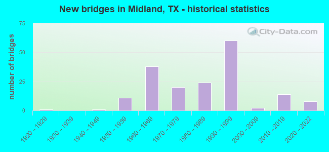
- New bridges - historical statistics
- 11920-1929
- 11940-1949
- 111950-1959
- 381960-1969
- 201970-1979
- 241980-1989
- 601990-1999
- 22000-2009
- 142010-2019
- 82020-2022
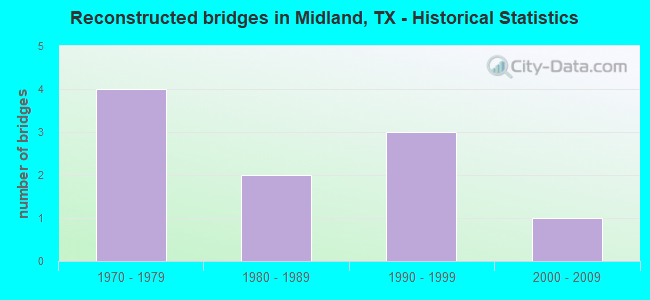
- Reconstructed bridges - Historical Statistics
- 41970-1979
- 21980-1989
- 31990-1999
- 12000-2009
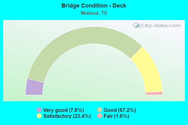
- Bridge Condition - Deck
- 7.8%Very good
- 67.2%Good
- 23.4%Satisfactory
- 1.6%Fair
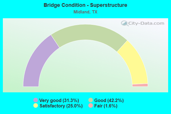
- Bridge Condition - Superstructure
- 31.3%Very good
- 42.2%Good
- 25.0%Satisfactory
- 1.6%Fair
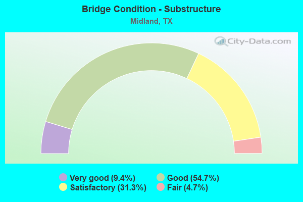
- Bridge Condition - Substructure
- 9.4%Very good
- 54.7%Good
- 31.3%Satisfactory
- 4.7%Fair
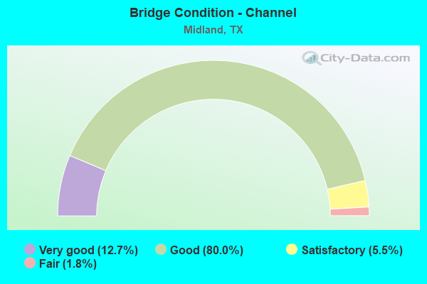
- Bridge Condition - Channel
- 12.7%Very good
- 80.0%Good
- 5.5%Satisfactory
- 1.8%Fair
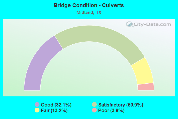
- Bridge Condition - Culverts
- 32.1%Good
- 50.9%Satisfactory
- 13.2%Fair
- 3.8%Poor
Find on map >> Show street view
Structure Number: 61650171807003, Location: 1.80 MI N OF IH 20 (Lat: 31.934811, Lng: -102.227511), Route carried "on" structure: State highway 1788, Year Built: 1988, Status: Open, Structure Length: 0.85m (2.79ft), Average Daily Traffic: 3,079 (year 2020), Truck Traffic: 16%, Average Future Daily Traffic: 10,870 (year 2037), Design Load: HS 20, Features Intersected: DRAIN
Minimum Vertical Clearance: 30+ m (98+ ft), Kilometerpoint: 17.701, Lanes on structure: 5, Owner: State Highway Agency, Approaching Roadway Width: 21.9m (71.9ft), Material/Design: Concrete, Design/Construction: Culvert, Number Of Spans In Main Unit: 5, Length of Maximum Span: 1.5m (4.9ft), Curb-To-Curb Width: 21.9m (71.9ft), Out-to-Out Width: 22.1m (72.5ft)
Condition: Channel: Good, Culverts: Good, Operating Rating: 39.9 metric tons, Method Used To Determine Operating Rating: Load Factor (LF), Inventory Rating: 23.6 metric tons, Method Used To Determine Inventory Rating: Load Factor (LF), Structural Evaluation: Equal to present minimum criteria, Deck Geometry: Somewhat better than minimum adequacy, Waterway Adequacy: Equal to present minimum criteria, Approach Roadway Alignment: Equal to present desirable criteria, Designated Inspection Frequency: Every 48 months, Inspection Date: Febuary 2021, Deck Structure Type: Concrete Cast-file-Place, Wearing Surface/Protective System: Wearing Surface: Bituminous
Find on map >> Show street view
Structure Number: 61650171807233, Location: 0.72 MI E OF SH 349 (Lat: 32.005281, Lng: -102.250164), Route carried "on" structure: State highway 349, Year Built: 2008, Status: Open, Structure Length: 4.15m (13.62ft), Average Daily Traffic: 16,714 (year 2020), Truck Traffic: 29%, Average Future Daily Traffic: 14,160 (year 2033), Design Load: HS 20, Features Intersected: JAL DRAW, Facility Carried by Structure: W CR 60
Minimum Vertical Clearance: 30+ m (98+ ft), Kilometerpoint: 0.000, Lanes on structure: 2, Owner: State Highway Agency, Approaching Roadway Width: 10.1m (33.1ft), Skew: 4 degrees, Material/Design: Concrete, Design/Construction: Culvert, Number Of Spans In Main Unit: 9, Length of Maximum Span: 3.0m (9.8ft), Curb-To-Curb Width: 10.3m (33.8ft), Out-to-Out Width: 11.0m (36.1ft)
Condition: Channel: Good, Culverts: Good, Operating Rating: 54.4 metric tons, Method Used To Determine Operating Rating: Assigned rating based on Load Factor Design (LFD) reported in metric tons, Inventory Rating: 32.7 metric tons, Method Used To Determine Inventory Rating: Assigned rating based on Load Factor Design (LFD) reported in metric tons, Structural Evaluation: Better than present minimum criteria, Deck Geometry: Meets minimum limits, Waterway Adequacy: Superior to present desirable criteria, Approach Roadway Alignment: Equal to present desirable criteria, Designated Inspection Frequency: Every 48 months, Inspection Date: Febuary 2021, Deck Structure Type: Other, Wearing Surface/Protective System: Wearing Surface: Bituminous
Find on map >> Show street view
Structure Number: 61650171807234, Location: 2.15 MI SW OF SH 158 (Lat: 32.006694, Lng: -102.261222), Route carried "on" structure: State highway 349, Year Built: 2010, Status: Open, Structure Length: 8.69m (28.51ft), Average Daily Traffic: 1,300 (year 2010), Truck Traffic: 3%, Average Future Daily Traffic: 1,300 (year 2030), Design Load: HL 93, Features Intersected: JAL DRAW
Minimum Vertical Clearance: 30+ m (98+ ft), Kilometerpoint: 0.000, Lanes on structure: 2, Owner: State Highway Agency, Approaching Roadway Width: 13.4m (44.0ft), Material/Design: Prestressed concrete, Design/Construction: Stringer/Multi-beam, Number Of Spans In Main Unit: 4, Length of Maximum Span: 21.6m (70.9ft), Curb-To-Curb Width: 13.4m (44.0ft), Out-to-Out Width: 14.0m (45.9ft)
Condition: Deck: Satisfactory, Superstructure: Very good, Substructure: Good, Channel: Good, Operating Rating: 54.4 metric tons, Method Used To Determine Operating Rating: Assigned ratings based on Load and Resistance Factor Design (LRFD) reported in metric tons, Inventory Rating: 32.7 metric tons, Method Used To Determine Inventory Rating: Assigned ratings based on Load and Resistance Factor Design (LRFD) reported in metric tons, Structural Evaluation: Better than present minimum criteria, Deck Geometry: Equal to present desirable criteria, Waterway Adequacy: Superior to present desirable criteria, Approach Roadway Alignment: Equal to present desirable criteria, Designated Inspection Frequency: Every 24 months, Inspection Date: July 2020, Deck Structure Type: Concrete Precast Panels
Find on map >> Show street view
Structure Number: 61650228301001, Location: 0.10 MI W OF LP 250 (Lat: 31.959711, Lng: -102.143200), Route carried "on" structure: State highway 662, Year Built: 1982, Status: Open, Structure Length: 1.77m (5.81ft), Average Daily Traffic: 3,461 (year 2017), Truck Traffic: 24%, Average Future Daily Traffic: 4,990 (year 2033), Design Load: HS 20, Features Intersected: DRAIN
Minimum Vertical Clearance: 30+ m (98+ ft), Kilometerpoint: 8.233, Lanes on structure: 2, Owner: State Highway Agency, Approaching Roadway Width: 12.2m (40.0ft), Skew: 3 degrees, Material/Design: Concrete, Design/Construction: Culvert, Number Of Spans In Main Unit: 9, Length of Maximum Span: 1.5m (4.9ft), Curb-To-Curb Width: 17.1m (56.1ft), Out-to-Out Width: 17.5m (57.4ft)
Condition: Channel: Satisfactory, Culverts: Satisfactory, Operating Rating: 39.9 metric tons, Method Used To Determine Operating Rating: Load Factor (LF), Inventory Rating: 23.6 metric tons, Method Used To Determine Inventory Rating: Load Factor (LF), Structural Evaluation: Equal to present minimum criteria, Deck Geometry: Superior to present desirable criteria, Waterway Adequacy: Equal to present minimum criteria, Approach Roadway Alignment: Equal to present desirable criteria, Designated Inspection Frequency: Every 48 months, Inspection Date: Febuary 2021, Deck Structure Type: Concrete Cast-file-Place, Wearing Surface/Protective System: Wearing Surface: Bituminous
Find on map >> Show street view
Structure Number: 61650229602008, Location: 1.87 MI SW OF SH 349 (Lat: 31.947361, Lng: -102.269439), Route carried "on" structure: ServiceState highway 191, Year Built: 1983, Status: Open, Structure Length: 0.91m (2.99ft), Average Daily Traffic: 1,980 (year 2017), Truck Traffic: 4%, Average Future Daily Traffic: 2,770 (year 2037), Features Intersected: DRAIN
Minimum Vertical Clearance: 30+ m (98+ ft), Kilometerpoint: 4.550, Lanes on structure: 2, Owner: State Highway Agency, Approaching Roadway Width: 9.8m (32.2ft), Material/Design: Concrete, Design/Construction: Culvert, Number Of Spans In Main Unit: 4, Length of Maximum Span: 2.1m (6.9ft), Out-to-Out Width: 17.5m (57.4ft)
Condition: Channel: Good, Culverts: Good, Operating Rating: 32.7 metric tons, Method Used To Determine Operating Rating: Field evaluation and documented engineering judgment, Inventory Rating: 24.5 metric tons, Method Used To Determine Inventory Rating: Field evaluation and documented engineering judgment, Structural Evaluation: Equal to present minimum criteria, Waterway Adequacy: Better than present minimum criteria, Approach Roadway Alignment: Equal to present desirable criteria, Designated Inspection Frequency: Every 24 months, Inspection Date: Febuary 2021
Find on map >> Show street view
Structure Number: 61650229602009, Location: 0.55 MI SW OF SH 349 (Lat: 31.963325, Lng: -102.256919), Route carried "on" structure: ServiceState highway 191, Year Built: 1983, Status: Open, Structure Length: 0.79m (2.59ft), Average Daily Traffic: 2,000 (year 2017), Truck Traffic: 4%, Average Future Daily Traffic: 2,770 (year 2037), Features Intersected: DRAIN
Minimum Vertical Clearance: 30+ m (98+ ft), Kilometerpoint: 6.685, Lanes on structure: 2, Owner: State Highway Agency, Approaching Roadway Width: 9.8m (32.2ft), Material/Design: Concrete, Design/Construction: Culvert, Number Of Spans In Main Unit: 3, Length of Maximum Span: 2.4m (7.9ft), Out-to-Out Width: 17.5m (57.4ft)
Condition: Channel: Good, Culverts: Good, Operating Rating: 32.7 metric tons, Method Used To Determine Operating Rating: Field evaluation and documented engineering judgment, Inventory Rating: 24.5 metric tons, Method Used To Determine Inventory Rating: Field evaluation and documented engineering judgment, Structural Evaluation: Equal to present minimum criteria, Waterway Adequacy: Better than present minimum criteria, Approach Roadway Alignment: Equal to present desirable criteria, Designated Inspection Frequency: Every 24 months, Inspection Date: Febuary 2021
Find on map >> Show street view
Structure Number: 61650229602011, Location: SH 191 & FM 1788 (Lat: 31.970261, Lng: -102.252244), Route carried "on" structure: State highway 191, Year Built: 1988, Status: Open, Structure Length: 13.72m (45.01ft), Average Daily Traffic: 14,580 (year 2013), Truck Traffic: 4%, Average Future Daily Traffic: 20,420 (year 2033), Design Load: HS 20, Features Intersected: FM 1788
Minimum Vertical Clearance: 30+ m (98+ ft), Kilometerpoint: 7.496, Lanes on structure: 2, Lanes under structure: 8, Owner: State Highway Agency, Approaching Roadway Width: 11.6m (38.1ft), Skew: 4 degrees, Material/Design: Prestressed concrete, Design/Construction: Stringer/Multi-beam, Number Of Spans In Main Unit: 4, Number Of Approach Spans: 2, Length of Maximum Span: 27.4m (89.9ft), Curb-To-Curb Width: 11.2m (36.7ft), Out-to-Out Width: 12.2m (40.0ft)
Condition: Deck: Good, Superstructure: Good, Substructure: Good, Operating Rating: 54.4 metric tons, Method Used To Determine Operating Rating: Assigned rating based on Load Factor Design (LFD) reported in metric tons, Inventory Rating: 32.7 metric tons, Method Used To Determine Inventory Rating: Assigned rating based on Load Factor Design (LFD) reported in metric tons, Structural Evaluation: Better than present minimum criteria, Deck Geometry: Somewhat better than minimum adequacy, Underclear: Equal to present minimum criteria, Approach Roadway Alignment: Equal to present desirable criteria, Designated Inspection Frequency: Every 24 months, Inspection Date: August 2021, Deck Structure Type: Concrete Precast Panels, Wearing Surface/Protective System: Wearing Surface: Bituminous, Deck Protection: Epoxy Coated Reinforcing
Find on map >> Show street view
Structure Number: 61650229602012, Location: SH 191 & FM 1788 (Lat: 31.970036, Lng: -102.252164), Route carried "on" structure: State highway 191, Year Built: 1988, Status: Open, Structure Length: 13.72m (45.01ft), Average Daily Traffic: 14,580 (year 2013), Truck Traffic: 4%, Average Future Daily Traffic: 20,420 (year 2033), Design Load: HS 20, Features Intersected: FM 1788
Minimum Vertical Clearance: 30+ m (98+ ft), Kilometerpoint: 7.496, Lanes on structure: 2, Lanes under structure: 8, Owner: State Highway Agency, Approaching Roadway Width: 11.6m (38.1ft), Skew: 4 degrees, Material/Design: Prestressed concrete, Design/Construction: Stringer/Multi-beam, Number Of Spans In Main Unit: 4, Number Of Approach Spans: 2, Length of Maximum Span: 27.4m (89.9ft), Curb-To-Curb Width: 11.3m (37.1ft), Out-to-Out Width: 12.2m (40.0ft)
Condition: Deck: Good, Superstructure: Very good, Substructure: Good, Operating Rating: 54.4 metric tons, Method Used To Determine Operating Rating: Assigned rating based on Load Factor Design (LFD) reported in metric tons, Inventory Rating: 32.7 metric tons, Method Used To Determine Inventory Rating: Assigned rating based on Load Factor Design (LFD) reported in metric tons, Structural Evaluation: Better than present minimum criteria, Deck Geometry: Somewhat better than minimum adequacy, Underclear: Equal to present minimum criteria, Approach Roadway Alignment: Equal to present desirable criteria, Designated Inspection Frequency: Every 24 months, Inspection Date: August 2021, Deck Structure Type: Concrete Precast Panels, Wearing Surface/Protective System: Wearing Surface: Bituminous, Deck Protection: Epoxy Coated Reinforcing
Find on map >> Show street view
Structure Number: 61650229602017, Location: 1.85 MI NE OF ECTOR C/L (Lat: 31.947639, Lng: -102.269778), Route carried "on" structure: State highway 191, Year Built: 1992, Status: Open, Structure Length: 0.94m (3.08ft), Average Daily Traffic: 5,000 (year 2014), Truck Traffic: 25%, Average Future Daily Traffic: 7,500 (year 2034), Design Load: HS 20, Features Intersected: DRAIN
Minimum Vertical Clearance: 30+ m (98+ ft), Kilometerpoint: 4.550, Lanes on structure: 4, Owner: State Highway Agency, Approaching Roadway Width: 24.4m (80.1ft), Skew: 20 degrees, Material/Design: Concrete, Design/Construction: Culvert, Number Of Spans In Main Unit: 4, Length of Maximum Span: 2.1m (6.9ft)
Condition: Channel: Good, Culverts: Good, Operating Rating: 39.9 metric tons, Method Used To Determine Operating Rating: Load Factor (LF), Inventory Rating: 23.6 metric tons, Method Used To Determine Inventory Rating: Load Factor (LF), Structural Evaluation: Somewhat better than minimum adequacy, Waterway Adequacy: Equal to present minimum criteria, Approach Roadway Alignment: Equal to present desirable criteria, Designated Inspection Frequency: Every 48 months, Inspection Date: July 2018
Find on map >> Show street view
Structure Number: 61650229602018, Location: 3.15 MI NE OF ECTOR C/L (Lat: 31.963778, Lng: -102.257650), Route carried "on" structure: State highway 191, Year Built: 1992, Status: Open, Structure Length: 0.79m (2.59ft), Average Daily Traffic: 5,000 (year 2014), Truck Traffic: 25%, Average Future Daily Traffic: 7,500 (year 2034), Design Load: HS 20, Features Intersected: DRAIN
Minimum Vertical Clearance: 30+ m (98+ ft), Kilometerpoint: 6.685, Lanes on structure: 6, Owner: State Highway Agency, Approaching Roadway Width: 34.1m (111.9ft), Skew: 20 degrees, Material/Design: Concrete, Design/Construction: Culvert, Number Of Spans In Main Unit: 3, Length of Maximum Span: 2.4m (7.9ft)
Condition: Channel: Good, Culverts: Good, Operating Rating: 39.9 metric tons, Method Used To Determine Operating Rating: Load Factor (LF), Inventory Rating: 23.6 metric tons, Method Used To Determine Inventory Rating: Load Factor (LF), Structural Evaluation: Somewhat better than minimum adequacy, Waterway Adequacy: Equal to present minimum criteria, Approach Roadway Alignment: Equal to present desirable criteria, Designated Inspection Frequency: Every 48 months, Inspection Date: July 2018
Find on map >> Show street view
Structure Number: 6165022960203, Location: 4.50 Mi W of LP 250 (Lat: 31.980308, Lng: -102.228075), Route carried "on" structure: State highway 191, Year Built: 1993, Status: Open, Structure Length: 7.01m (23.00ft), Average Daily Traffic: 14,280 (year 2013), Truck Traffic: 4%, Average Future Daily Traffic: 19,990 (year 2033), Design Load: HS 20, Features Intersected: CR 1275
Minimum Vertical Clearance: 30+ m (98+ ft), Kilometerpoint: 10.166, Lanes on structure: 2, Lanes under structure: 2, Owner: State Highway Agency, Approaching Roadway Width: 11.3m (37.1ft), Material/Design: Prestressed concrete, Design/Construction: Stringer/Multi-beam, Number Of Spans In Main Unit: 1, Number Of Approach Spans: 2, Length of Maximum Span: 33.5m (109.9ft), Curb-To-Curb Width: 11.4m (37.4ft), Out-to-Out Width: 12.3m (40.4ft)
Condition: Deck: Good, Superstructure: Good, Substructure: Good, Operating Rating: 54.4 metric tons, Method Used To Determine Operating Rating: Assigned rating based on Load Factor Design (LFD) reported in metric tons, Inventory Rating: 32.7 metric tons, Method Used To Determine Inventory Rating: Assigned rating based on Load Factor Design (LFD) reported in metric tons, Structural Evaluation: Better than present minimum criteria, Deck Geometry: Somewhat better than minimum adequacy, Underclear: Superior to present desirable criteria, Approach Roadway Alignment: Equal to present desirable criteria, Designated Inspection Frequency: Every 24 months, Inspection Date: August 2021, Deck Structure Type: Concrete Cast-file-Place, Wearing Surface/Protective System: Wearing Surface: Bituminous, Deck Protection: Epoxy Coated Reinforcing
Find on map >> Show street view
Structure Number: 61650229602031, Location: 4.5 Mi W of LP 250 (Lat: 31.979800, Lng: -102.228547), Route carried "on" structure: State highway 191, Year Built: 1997, Status: Open, Structure Length: 7.01m (23.00ft), Average Daily Traffic: 14,280 (year 2013), Truck Traffic: 4%, Average Future Daily Traffic: 19,990 (year 2033), Design Load: HS 20, Features Intersected: CR 1275
Minimum Vertical Clearance: 5.61m (18.41ft), Kilometerpoint: 10.166, Lanes on structure: 2, Lanes under structure: 2, Owner: State Highway Agency, Approaching Roadway Width: 11.3m (37.1ft), Material/Design: Prestressed concrete, Design/Construction: Stringer/Multi-beam, Number Of Spans In Main Unit: 1, Number Of Approach Spans: 2, Length of Maximum Span: 33.5m (109.9ft), Curb-To-Curb Width: 11.4m (37.4ft), Out-to-Out Width: 12.3m (40.4ft)
Condition: Deck: Good, Superstructure: Very good, Substructure: Good, Operating Rating: 54.4 metric tons, Method Used To Determine Operating Rating: Assigned rating based on Load Factor Design (LFD) reported in metric tons, Inventory Rating: 32.7 metric tons, Method Used To Determine Inventory Rating: Assigned rating based on Load Factor Design (LFD) reported in metric tons, Structural Evaluation: Better than present minimum criteria, Deck Geometry: Somewhat better than minimum adequacy, Underclear: Superior to present desirable criteria, Approach Roadway Alignment: Equal to present desirable criteria, Designated Inspection Frequency: Every 24 months, Inspection Date: August 2021, Deck Structure Type: Concrete Cast-file-Place, Wearing Surface/Protective System: Wearing Surface: Bituminous, Deck Protection: Epoxy Coated Reinforcing
Find on map >> Show street view
Structure Number: 61650B00020001, Location: 0.7 MI S OF WADLEY AVE (Lat: 32.017544, Lng: -102.088617), Route carried "on" structure: City street , Year Built: 1957, Status: Open, Structure Length: 1.59m (5.22ft), Average Daily Traffic: 13,890 (year 2015), Average Future Daily Traffic: 18,000 (year 2037), Design Load: H 20, Features Intersected: SCHARBAUER DRAW, Facility Carried by Structure: NORTH A ST
Minimum Vertical Clearance: 30+ m (98+ ft), Kilometerpoint: 1.963, Lanes on structure: 6, Owner: City or Municipal Highway Agency, Approaching Roadway Width: 21.0m (68.9ft), Skew: 2 degrees, Material/Design: Concrete, Design/Construction: Culvert, Number Of Spans In Main Unit: 5, Length of Maximum Span: 2.7m (8.9ft), Curb or Sidewalk Widths: Left: 1.6m (5.2ft), Right: 1.6m (5.2ft), Curb-To-Curb Width: 22.9m (75.1ft), Out-to-Out Width: 26.5m (86.9ft)
Condition: Channel: Good, Culverts: Fair, Operating Rating: 39.9 metric tons, Method Used To Determine Operating Rating: Load Factor (LF), Inventory Rating: 23.6 metric tons, Method Used To Determine Inventory Rating: Load Factor (LF), Structural Evaluation: Somewhat better than minimum adequacy, Deck Geometry: Meets minimum limits, Waterway Adequacy: Better than present minimum criteria, Approach Roadway Alignment: Equal to present desirable criteria, Designated Inspection Frequency: Every 24 months, Inspection Date: Febuary 2021, Deck Structure Type: Concrete Cast-file-Place, Wearing Surface/Protective System: Wearing Surface: Monolithic Concrete
Find on map >> Show street view
Structure Number: 61650B01520001, Location: 0.3 MI N OF FRONT ST (Lat: 32.007431, Lng: -102.062467), Route carried "on" structure: City street , Year Built: 1990, Status: Posted for load, Structure Length: 1.16m (3.81ft), Average Daily Traffic: 2,530 (year 2015), Average Future Daily Traffic: 2,500 (year 2037), Design Load: H 20, Features Intersected: DRAIN, Facility Carried by Structure: CARVER ST
Minimum Vertical Clearance: 30+ m (98+ ft), Kilometerpoint: 0.370, Lanes on structure: 2, Owner: City or Municipal Highway Agency, Approaching Roadway Width: 12.2m (40.0ft), Material/Design: Concrete, Design/Construction: Culvert, Number Of Spans In Main Unit: 4, Length of Maximum Span: 2.7m (8.9ft), Curb or Sidewalk Widths: Left: 1.5m (4.9ft), Right: 1.5m (4.9ft), Curb-To-Curb Width: 12.2m (40.0ft), Out-to-Out Width: 15.9m (52.2ft)
Condition: Channel: Satisfactory, Culverts: Fair, Operating Rating: 32.7 metric tons, Method Used To Determine Operating Rating: Field evaluation and documented engineering judgment, Inventory Rating: 24.5 metric tons, Method Used To Determine Inventory Rating: Field evaluation and documented engineering judgment, Structural Evaluation: Somewhat better than minimum adequacy, Deck Geometry: Equal to present minimum criteria, Waterway Adequacy: Better than present minimum criteria, Approach Roadway Alignment: Equal to present desirable criteria, Designated Inspection Frequency: Every 24 months, Inspection Date: Febuary 2021, Deck Structure Type: Concrete Cast-file-Place, Wearing Surface/Protective System: Wearing Surface: Monolithic Concrete
Find on map >> Show street view
Structure Number: 61650B03220001, Location: 1.1 MI N OF FRONT ST (Lat: 32.022944, Lng: -102.054694), Route carried "on" structure: City street , Year Built: 1957, Year Reconstructed: 1985, Status: Open, Structure Length: 2.68m (8.79ft), Average Daily Traffic: 9,200 (year 2015), Average Future Daily Traffic: 7,515 (year 2037), Features Intersected: MIDLAND DRAW, Facility Carried by Structure: N FAIRGROUNDS RD
Minimum Vertical Clearance: 30+ m (98+ ft), Kilometerpoint: 1.690, Lanes on structure: 5, Owner: City or Municipal Highway Agency, Approaching Roadway Width: 19.5m (64.0ft), Material/Design: Concrete, Design/Construction: Culvert, Number Of Spans In Main Unit: 9, Length of Maximum Span: 2.7m (8.9ft), Curb or Sidewalk Widths: Left: 1.6m (5.2ft), Right: 1.6m (5.2ft), Curb-To-Curb Width: 19.5m (64.0ft), Out-to-Out Width: 23.2m (76.1ft)
Condition: Channel: Good, Culverts: Satisfactory, Operating Rating: 32.7 metric tons, Method Used To Determine Operating Rating: Field evaluation and documented engineering judgment, Inventory Rating: 24.5 metric tons, Method Used To Determine Inventory Rating: Field evaluation and documented engineering judgment, Structural Evaluation: Equal to present minimum criteria, Deck Geometry: Meets minimum limits, Waterway Adequacy: Equal to present minimum criteria, Approach Roadway Alignment: Equal to present desirable criteria, Designated Inspection Frequency: Every 24 months, Inspection Date: Febuary 2021, Deck Structure Type: Concrete Cast-file-Place, Wearing Surface/Protective System: Wearing Surface: Monolithic Concrete
Find on map >> Show street view
Structure Number: 61650B03220002, Location: 0.15 MI N OF FRONT ST (Lat: 32.010481, Lng: -102.050689), Route carried "on" structure: City street , Year Built: 1996, Status: Open, Structure Length: 1.37m (4.49ft), Average Daily Traffic: 9,650 (year 2015), Average Future Daily Traffic: 7,500 (year 2037), Features Intersected: MULBERRY CHANNEL, Facility Carried by Structure: N FAIRGROUNDS RD
Minimum Vertical Clearance: 30+ m (98+ ft), Kilometerpoint: 0.161, Lanes on structure: 5, Owner: City or Municipal Highway Agency, Approaching Roadway Width: 20.1m (65.9ft), Skew: 1 degrees, Material/Design: Concrete, Design/Construction: Culvert, Number Of Spans In Main Unit: 4, Length of Maximum Span: 3.0m (9.8ft), Curb or Sidewalk Widths: Left: 1.5m (4.9ft), Right: 1.5m (4.9ft), Curb-To-Curb Width: 20.2m (66.3ft), Out-to-Out Width: 24.0m (78.7ft)
Condition: Channel: Good, Culverts: Satisfactory, Operating Rating: 32.7 metric tons, Method Used To Determine Operating Rating: Field evaluation and documented engineering judgment, Inventory Rating: 24.5 metric tons, Method Used To Determine Inventory Rating: Field evaluation and documented engineering judgment, Structural Evaluation: Equal to present minimum criteria, Deck Geometry: Somewhat better than minimum adequacy, Waterway Adequacy: Better than present minimum criteria, Approach Roadway Alignment: Equal to present desirable criteria, Designated Inspection Frequency: Every 24 months, Inspection Date: Febuary 2021, Deck Structure Type: Concrete Cast-file-Place, Wearing Surface/Protective System: Wearing Surface: Monolithic Concrete
Find on map >> Show street view
Structure Number: 61650B03640001, Location: 0.9 MI S OF LP 250 (Lat: 32.025011, Lng: -102.108703), Route carried "on" structure: City street , Year Built: 1970, Status: Open, Structure Length: 1.92m (6.30ft), Average Daily Traffic: 14,010 (year 2015), Average Future Daily Traffic: 18,505 (year 2037), Design Load: H 20, Features Intersected: JAL DRAW, Facility Carried by Structure: GARFIELD ST
Minimum Vertical Clearance: 30+ m (98+ ft), Kilometerpoint: 2.253, Lanes on structure: 5, Owner: City or Municipal Highway Agency, Approaching Roadway Width: 19.5m (64.0ft), Skew: 1 degrees, Material/Design: Concrete, Design/Construction: Culvert, Number Of Spans In Main Unit: 7, Length of Maximum Span: 2.4m (7.9ft), Curb or Sidewalk Widths: Left: 1.0m (3.3ft), Right: 1.3m (4.3ft), Curb-To-Curb Width: 19.5m (64.0ft), Out-to-Out Width: 22.7m (74.5ft)
Condition: Channel: Good, Culverts: Satisfactory, Operating Rating: 39.9 metric tons, Method Used To Determine Operating Rating: Load Factor (LF), Inventory Rating: 23.6 metric tons, Method Used To Determine Inventory Rating: Load Factor (LF), Structural Evaluation: Somewhat better than minimum adequacy, Deck Geometry: Meets minimum limits, Waterway Adequacy: Better than present minimum criteria, Approach Roadway Alignment: Equal to present desirable criteria, Designated Inspection Frequency: Every 24 months, Inspection Date: Febuary 2021, Deck Structure Type: Concrete Cast-file-Place, Wearing Surface/Protective System: Wearing Surface: Bituminous
Find on map >> Show street view
Structure Number: 61650B04240001, Location: 0.1 MI W OF MIDKIFF RD (Lat: 32.026558, Lng: -102.128081), Route carried "on" structure: City street , Year Built: 1996, Status: Open, Structure Length: 1.89m (6.20ft), Average Daily Traffic: 2,400 (year 2015), Average Future Daily Traffic: 4,000 (year 2037), Features Intersected: NW MIDLAND DRAIN CHANNEL, Facility Carried by Structure: HAYNES AVE
Minimum Vertical Clearance: 30+ m (98+ ft), Kilometerpoint: 1.690, Lanes on structure: 2, Owner: City or Municipal Highway Agency, Approaching Roadway Width: 15.2m (49.9ft), Skew: 3 degrees, Material/Design: Concrete, Design/Construction: Culvert, Number Of Spans In Main Unit: 5, Length of Maximum Span: 3.0m (9.8ft), Curb or Sidewalk Widths: Left: 1.0m (3.3ft), Right: 1.0m (3.3ft), Curb-To-Curb Width: 15.2m (49.9ft), Out-to-Out Width: 18.6m (61.0ft)
Condition: Channel: Good, Culverts: Satisfactory, Operating Rating: 32.7 metric tons, Method Used To Determine Operating Rating: Field evaluation and documented engineering judgment, Inventory Rating: 24.5 metric tons, Method Used To Determine Inventory Rating: Field evaluation and documented engineering judgment, Structural Evaluation: Equal to present minimum criteria, Deck Geometry: Superior to present desirable criteria, Waterway Adequacy: Better than present minimum criteria, Approach Roadway Alignment: Equal to present desirable criteria, Designated Inspection Frequency: Every 24 months, Inspection Date: Febuary 2021, Deck Structure Type: Concrete Cast-file-Place, Wearing Surface/Protective System: Wearing Surface: Monolithic Concrete
Find on map >> Show street view
Structure Number: 61650B04260001, Location: 0.7 MI E OF SH 349 (Lat: 32.021803, Lng: -102.068097), Route carried "on" structure: City street , Year Built: 1970, Status: Posted for load, Structure Length: 2.04m (6.69ft), Average Daily Traffic: 4,950 (year 2017), Average Future Daily Traffic: 2,500 (year 2037), Design Load: H 20, Features Intersected: MIDLAND DRAW, Facility Carried by Structure: SCHARBAUER DR WB
Minimum Vertical Clearance: 30+ m (98+ ft), Kilometerpoint: 1.176, Lanes on structure: 2, Owner: City or Municipal Highway Agency, Approaching Roadway Width: 9.8m (32.2ft), Skew: 1 degrees, Material/Design: Concrete, Design/Construction: Culvert, Number Of Spans In Main Unit: 6, Length of Maximum Span: 3.0m (9.8ft), Curb or Sidewalk Widths: Left: 1.2m (3.9ft), Right: 1.2m (3.9ft), Curb-To-Curb Width: 9.8m (32.2ft), Out-to-Out Width: 12.8m (42.0ft)
Condition: Channel: Good, Culverts: Poor, Operating Rating: 32.7 metric tons, Method Used To Determine Operating Rating: Field evaluation and documented engineering judgment, Inventory Rating: 24.5 metric tons, Method Used To Determine Inventory Rating: Field evaluation and documented engineering judgment, Structural Evaluation: Meets minimum limits, Deck Geometry: Meets minimum limits, Waterway Adequacy: Better than present minimum criteria, Approach Roadway Alignment: Equal to present desirable criteria, Designated Inspection Frequency: Every 24 months, Inspection Date: Febuary 2021, Deck Structure Type: Concrete Cast-file-Place, Wearing Surface/Protective System: Wearing Surface: Monolithic Concrete
Find on map >> Show street view
Structure Number: 61650B04260002, Location: 0.7 MI E OF SH 349 (Lat: 32.021486, Lng: -102.068228), Route carried "on" structure: City street , Year Built: 1986, Status: Posted for load, Structure Length: 3.72m (12.20ft), Average Daily Traffic: 4,160 (year 2015), Average Future Daily Traffic: 2,500 (year 2037), Features Intersected: MIDLAND DRAW, Facility Carried by Structure: SCHARBAUER DR EB
Minimum Vertical Clearance: 30+ m (98+ ft), Kilometerpoint: 1.176, Lanes on structure: 2, Owner: City or Municipal Highway Agency, Approaching Roadway Width: 9.8m (32.2ft), Skew: 4 degrees, Material/Design: Concrete, Design/Construction: Culvert, Number Of Spans In Main Unit: 8, Length of Maximum Span: 3.0m (9.8ft), Curb or Sidewalk Widths: Left: 1.2m (3.9ft), Right: 1.2m (3.9ft), Curb-To-Curb Width: 9.8m (32.2ft), Out-to-Out Width: 12.8m (42.0ft)
Condition: Channel: Good, Culverts: Fair, Operating Rating: 32.7 metric tons, Method Used To Determine Operating Rating: Field evaluation and documented engineering judgment, Inventory Rating: 24.5 metric tons, Method Used To Determine Inventory Rating: Field evaluation and documented engineering judgment, Structural Evaluation: Somewhat better than minimum adequacy, Deck Geometry: Meets minimum limits, Waterway Adequacy: Better than present minimum criteria, Approach Roadway Alignment: Equal to present desirable criteria, Designated Inspection Frequency: Every 24 months, Inspection Date: Febuary 2021, Deck Structure Type: Concrete Cast-file-Place, Wearing Surface/Protective System: Wearing Surface: Monolithic Concrete
Find on map >> Show street view
Structure Number: 61650B04800001, Location: 0.1 MI N OF GOLF CRSE RD (Lat: 32.020639, Lng: -102.064244), Route carried "on" structure: City street , Year Built: 1957, Status: Open, Structure Length: 1.80m (5.91ft), Average Daily Traffic: 793 (year 2017), Average Future Daily Traffic: 1,470 (year 2037), Design Load: H 20, Features Intersected: MIDLAND DRAW, Facility Carried by Structure: N JACKSON ST
Minimum Vertical Clearance: 30+ m (98+ ft), Kilometerpoint: 0.193, Lanes on structure: 2, Owner: City or Municipal Highway Agency, Approaching Roadway Width: 11.0m (36.1ft), Material/Design: Concrete, Design/Construction: Culvert, Number Of Spans In Main Unit: 6, Length of Maximum Span: 2.7m (8.9ft), Curb or Sidewalk Widths: Left: 1.6m (5.2ft), Right: 1.6m (5.2ft), Curb-To-Curb Width: 11.0m (36.1ft), Out-to-Out Width: 14.6m (47.9ft)
Condition: Channel: Very good, Culverts: Fair, Operating Rating: 32.7 metric tons, Method Used To Determine Operating Rating: Field evaluation and documented engineering judgment, Inventory Rating: 24.5 metric tons, Method Used To Determine Inventory Rating: Field evaluation and documented engineering judgment, Structural Evaluation: Somewhat better than minimum adequacy, Deck Geometry: Better than present minimum criteria, Waterway Adequacy: Better than present minimum criteria, Approach Roadway Alignment: Equal to present desirable criteria, Designated Inspection Frequency: Every 24 months, Inspection Date: Febuary 2021, Deck Structure Type: Concrete Cast-file-Place, Wearing Surface/Protective System: Wearing Surface: Monolithic Concrete
Find on map >> Show street view
Structure Number: 61650B05200001, Location: 0.75 MI S OF WADLEY AVE (Lat: 32.021119, Lng: -102.071828), Route carried "on" structure: City street , Year Built: 1957, Status: Posted for load, Structure Length: 1.49m (4.89ft), Average Daily Traffic: 8,450 (year 2015), Average Future Daily Traffic: 10,000 (year 2037), Design Load: H 20, Features Intersected: SCHARBAUER DRAW, Facility Carried by Structure: N LAMESA RD
Minimum Vertical Clearance: 30+ m (98+ ft), Kilometerpoint: 4.426, Lanes on structure: 4, Owner: City or Municipal Highway Agency, Approaching Roadway Width: 13.7m (44.9ft), Material/Design: Concrete, Design/Construction: Culvert, Number Of Spans In Main Unit: 5, Length of Maximum Span: 2.7m (8.9ft), Curb or Sidewalk Widths: Left: 1.6m (5.2ft), Right: 1.6m (5.2ft), Curb-To-Curb Width: 13.7m (44.9ft), Out-to-Out Width: 17.4m (57.1ft)
Condition: Channel: Good, Culverts: Fair, Operating Rating: 32.7 metric tons, Method Used To Determine Operating Rating: Field evaluation and documented engineering judgment, Inventory Rating: 24.5 metric tons, Method Used To Determine Inventory Rating: Field evaluation and documented engineering judgment, Structural Evaluation: Somewhat better than minimum adequacy, Deck Geometry: High priority of replacement, Waterway Adequacy: Equal to present minimum criteria, Approach Roadway Alignment: Equal to present desirable criteria, Length Of Structure Improvement: 1.49m (4.89ft), Designated Inspection Frequency: Every 24 months, Inspection Date: Febuary 2021, Bridge Improvement Cost: $4,000, Roadway Improvement Cost: $1,000, Total Project Cost: $5,000, Deck Structure Type: Concrete Cast-file-Place, Wearing Surface/Protective System: Wearing Surface: Monolithic Concrete
Find on map >> Show street view
Structure Number: 61650B05200002, Location: 0.4 MI N OF IH 20 BUS (Lat: 32.006269, Lng: -102.067078), Route carried "on" structure: City street , Year Built: 1960, Year Reconstructed: 1990, Status: Open, Structure Length: 1.55m (5.09ft), Average Daily Traffic: 9,330 (year 2015), Average Future Daily Traffic: 10,000 (year 2037), Design Load: HS 20, Features Intersected: MULBERRY CHANNEL, Facility Carried by Structure: N LAMESA RD
Minimum Vertical Clearance: 30+ m (98+ ft), Kilometerpoint: 7.701, Lanes on structure: 4, Owner: City or Municipal Highway Agency, Approaching Roadway Width: 20.1m (65.9ft), Skew: 3 degrees, Material/Design: Concrete, Design/Construction: Culvert, Number Of Spans In Main Unit: 4, Length of Maximum Span: 2.7m (8.9ft), Curb or Sidewalk Widths: Left: 1.5m (4.9ft), Right: 1.4m (4.6ft), Curb-To-Curb Width: 20.0m (65.6ft), Out-to-Out Width: 28.1m (92.2ft)
Condition: Channel: Good, Culverts: Satisfactory, Operating Rating: 39.9 metric tons, Method Used To Determine Operating Rating: Load Factor (LF), Inventory Rating: 23.6 metric tons, Method Used To Determine Inventory Rating: Load Factor (LF), Structural Evaluation: Somewhat better than minimum adequacy, Deck Geometry: Better than present minimum criteria, Waterway Adequacy: Equal to present minimum criteria, Approach Roadway Alignment: Equal to present desirable criteria, Designated Inspection Frequency: Every 24 months, Inspection Date: Febuary 2021, Deck Structure Type: Concrete Cast-file-Place, Wearing Surface/Protective System: Wearing Surface: Bituminous
Find on map >> Show street view
Structure Number: 61650B05200003, Location: 0.1 MI S OF WADLEY AVE (Lat: 32.030164, Lng: -102.074647), Route carried "on" structure: City street , Year Built: 1991, Status: Open, Structure Length: 5.24m (17.19ft), Average Daily Traffic: 7,810 (year 2015), Average Future Daily Traffic: 8,000 (year 2037), Design Load: HS 20, Features Intersected: MIDLAND DRAW, Facility Carried by Structure: N LAMESA RD
Minimum Vertical Clearance: 30+ m (98+ ft), Kilometerpoint: 5.552, Lanes on structure: 5, Owner: City or Municipal Highway Agency, Approaching Roadway Width: 20.1m (65.9ft), Skew: 6 degrees, Material/Design: Concrete, Design/Construction: Culvert, Number Of Spans In Main Unit: 8, Length of Maximum Span: 3.0m (9.8ft), Curb or Sidewalk Widths: Left: 1.5m (4.9ft), Right: 1.4m (4.6ft), Curb-To-Curb Width: 19.9m (65.3ft), Out-to-Out Width: 24.0m (78.7ft)
Condition: Channel: Good, Culverts: Satisfactory, Operating Rating: 39.9 metric tons, Method Used To Determine Operating Rating: Load Factor (LF), Inventory Rating: 23.6 metric tons, Method Used To Determine Inventory Rating: Load Factor (LF), Structural Evaluation: Somewhat better than minimum adequacy, Deck Geometry: Meets minimum limits, Waterway Adequacy: Equal to present minimum criteria, Approach Roadway Alignment: Equal to present desirable criteria, Designated Inspection Frequency: Every 24 months, Inspection Date: Febuary 2021, Deck Structure Type: Concrete Cast-file-Place, Wearing Surface/Protective System: Wearing Surface: Monolithic Concrete
Find on map >> Show street view
Structure Number: 61650B05680001, Location: 0.7 MI S OF WADLEY AVE (Lat: 32.020194, Lng: -102.078250), Route carried "on" structure: City street , Year Built: 1957, Status: Posted for load, Structure Length: 1.74m (5.71ft), Average Daily Traffic: 4,090 (year 2015), Average Future Daily Traffic: 7,000 (year 2037), Design Load: H 20, Features Intersected: SCHARBAUER DRAW, Facility Carried by Structure: N MAIN ST
Minimum Vertical Clearance: 30+ m (98+ ft), Kilometerpoint: 1.110, Lanes on structure: 4, Owner: City or Municipal Highway Agency, Approaching Roadway Width: 12.2m (40.0ft), Skew: 3 degrees, Material/Design: Concrete, Design/Construction: Culvert, Number Of Spans In Main Unit: 5, Length of Maximum Span: 2.7m (8.9ft), Curb or Sidewalk Widths: Left: 1.6m (5.2ft), Right: 1.6m (5.2ft), Curb-To-Curb Width: 12.2m (40.0ft), Out-to-Out Width: 15.9m (52.2ft)
Condition: Channel: Good, Culverts: Poor, Operating Rating: 32.7 metric tons, Method Used To Determine Operating Rating: Field evaluation and documented engineering judgment, Inventory Rating: 24.5 metric tons, Method Used To Determine Inventory Rating: Field evaluation and documented engineering judgment, Structural Evaluation: Meets minimum limits, Deck Geometry: High priority of replacement, Waterway Adequacy: Better than present minimum criteria, Approach Roadway Alignment: Equal to present desirable criteria, Length Of Structure Improvement: 1.74m (5.71ft), Designated Inspection Frequency: Every 24 months, Inspection Date: Febuary 2021, Bridge Improvement Cost: $5,000, Roadway Improvement Cost: $1,000, Total Project Cost: $6,000, Deck Structure Type: Concrete Cast-file-Place, Wearing Surface/Protective System: Wearing Surface: Monolithic Concrete
Find on map >> Show street view
Structure Number: 61650B06000001, Location: 0.05 MI E OF MIDKIFF RD (Lat: 32.023108, Lng: -102.124131), Route carried "on" structure: City street , Year Built: 1996, Status: Open, Structure Length: 1.98m (6.50ft), Average Daily Traffic: 1,183 (year 2013), Average Future Daily Traffic: 2,000 (year 2032), Features Intersected: NW MIDLAND DRAIN CHANNEL, Facility Carried by Structure: MAXWELL DR
Minimum Vertical Clearance: 30+ m (98+ ft), Kilometerpoint: 1.465, Lanes on structure: 2, Owner: City or Municipal Highway Agency, Approaching Roadway Width: 12.2m (40.0ft), Material/Design: Concrete, Design/Construction: Culvert, Number Of Spans In Main Unit: 6, Length of Maximum Span: 3.0m (9.8ft), Curb or Sidewalk Widths: Left: 0.7m (2.3ft), Right: 0.0m, Curb-To-Curb Width: 13.4m (44.0ft), Out-to-Out Width: 15.5m (50.9ft)
Condition: Channel: Good, Culverts: Satisfactory, Operating Rating: 32.7 metric tons, Method Used To Determine Operating Rating: Field evaluation and documented engineering judgment, Inventory Rating: 24.5 metric tons, Method Used To Determine Inventory Rating: Field evaluation and documented engineering judgment, Structural Evaluation: Equal to present minimum criteria, Deck Geometry: Equal to present desirable criteria, Waterway Adequacy: Better than present minimum criteria, Approach Roadway Alignment: Equal to present desirable criteria, Designated Inspection Frequency: Every 24 months, Inspection Date: Febuary 2021, Deck Structure Type: Concrete Cast-file-Place, Wearing Surface/Protective System: Wearing Surface: Monolithic Concrete
Find on map >> Show street view
Structure Number: 61650B06240001, Location: 0.5 MI S OF LP 250 (Lat: 32.025158, Lng: -102.126472), Route carried "on" structure: City street , Year Built: 1989, Status: Open, Structure Length: 2.87m (9.42ft), Average Daily Traffic: 25,240 (year 2015), Average Future Daily Traffic: 27,000 (year 2037), Design Load: HS 20, Features Intersected: NW MIDLAND DRAIN CHANNEL, Facility Carried by Structure: MIDKIFF RD
Minimum Vertical Clearance: 30+ m (98+ ft), Kilometerpoint: 5.684, Lanes on structure: 7, Base Highway Network: Yes, Owner: City or Municipal Highway Agency, Approaching Roadway Width: 24.4m (80.1ft), Skew: 5 degrees, Material/Design: Concrete, Design/Construction: Culvert, Number Of Spans In Main Unit: 5, Length of Maximum Span: 3.0m (9.8ft), Curb or Sidewalk Widths: Left: 1.3m (4.3ft), Right: 1.3m (4.3ft), Curb-To-Curb Width: 24.5m (80.4ft), Out-to-Out Width: 28.3m (92.8ft)
Condition: Channel: Good, Culverts: Satisfactory, Operating Rating: 39.9 metric tons, Method Used To Determine Operating Rating: Load Factor (LF), Inventory Rating: 23.6 metric tons, Method Used To Determine Inventory Rating: Load Factor (LF), Structural Evaluation: Somewhat better than minimum adequacy, Deck Geometry: High priority of replacement, Waterway Adequacy: Equal to present minimum criteria, Approach Roadway Alignment: Equal to present desirable criteria, Length Of Structure Improvement: 2.87m (9.42ft), Designated Inspection Frequency: Every 24 months, Inspection Date: Febuary 2021, Bridge Improvement Cost: $15,000, Roadway Improvement Cost: $4,000, Total Project Cost: $19,000, Deck Structure Type: Concrete Cast-file-Place, Wearing Surface/Protective System: Wearing Surface: Monolithic Concrete
Find on map >> Show street view
Structure Number: 61650B06340001, Location: 0.3 MI E OF N LAMESA RD (Lat: 32.025411, Lng: -102.068347), Route carried "on" structure: City street , Year Built: 1970, Status: Open, Structure Length: 1.95m (6.40ft), Average Daily Traffic: 2,001 (year 2017), Average Future Daily Traffic: 2,000 (year 2037), Design Load: H 20, Features Intersected: MIDLAND DRAW, Facility Carried by Structure: OAK AVE
Minimum Vertical Clearance: 30+ m (98+ ft), Kilometerpoint: 1.271, Lanes on structure: 2, Owner: City or Municipal Highway Agency, Approaching Roadway Width: 11.0m (36.1ft), Material/Design: Concrete, Design/Construction: Culvert, Number Of Spans In Main Unit: 6, Length of Maximum Span: 3.0m (9.8ft), Curb or Sidewalk Widths: Left: 1.4m (4.6ft), Right: 1.4m (4.6ft), Curb-To-Curb Width: 11.0m (36.1ft), Out-to-Out Width: 14.0m (45.9ft)
Condition: Channel: Very good, Culverts: Satisfactory, Operating Rating: 32.7 metric tons, Method Used To Determine Operating Rating: Field evaluation and documented engineering judgment, Inventory Rating: 24.5 metric tons, Method Used To Determine Inventory Rating: Field evaluation and documented engineering judgment, Structural Evaluation: Equal to present minimum criteria, Deck Geometry: Somewhat better than minimum adequacy, Waterway Adequacy: Better than present minimum criteria, Approach Roadway Alignment: Equal to present desirable criteria, Designated Inspection Frequency: Every 24 months, Inspection Date: Febuary 2021, Deck Structure Type: Concrete Cast-file-Place, Wearing Surface/Protective System: Wearing Surface: Monolithic Concrete
Find on map >> Show street view
Structure Number: 61650B06735001, Location: 0.2 MI S OF LP 250 (Lat: 32.027056, Lng: -102.140872), Route carried "on" structure: City street , Year Built: 1996, Status: Open, Structure Length: 1.65m (5.41ft), Average Daily Traffic: 790 (year 2015), Average Future Daily Traffic: 2,000 (year 2037), Features Intersected: NW MIDLAND DRAIN CHANNEL, Facility Carried by Structure: NORWOOD ST
Minimum Vertical Clearance: 30+ m (98+ ft), Kilometerpoint: 0.531, Lanes on structure: 2, Owner: City or Municipal Highway Agency, Approaching Roadway Width: 12.2m (40.0ft), Material/Design: Concrete, Design/Construction: Culvert, Number Of Spans In Main Unit: 5, Length of Maximum Span: 3.0m (9.8ft), Curb or Sidewalk Widths: Left: 1.6m (5.2ft), Right: 1.6m (5.2ft), Curb-To-Curb Width: 13.0m (42.7ft), Out-to-Out Width: 18.8m (61.7ft)
Condition: Channel: Good, Culverts: Good, Operating Rating: 32.7 metric tons, Method Used To Determine Operating Rating: Field evaluation and documented engineering judgment, Inventory Rating: 24.5 metric tons, Method Used To Determine Inventory Rating: Field evaluation and documented engineering judgment, Structural Evaluation: Equal to present minimum criteria, Deck Geometry: Superior to present desirable criteria, Waterway Adequacy: Better than present minimum criteria, Approach Roadway Alignment: Equal to present desirable criteria, Designated Inspection Frequency: Every 24 months, Inspection Date: Febuary 2021, Deck Structure Type: Concrete Cast-file-Place, Wearing Surface/Protective System: Wearing Surface: Monolithic Concrete
Find on map >> Show street view
Structure Number: 61650B09040001, Location: 0.5 MI E OF SH 349 (Lat: 32.031286, Lng: -102.075728), Route carried "on" structure: City street , Year Built: 1970, Status: Posted for load, Structure Length: 2.29m (7.51ft), Average Daily Traffic: 12,089 (year 2019), Average Future Daily Traffic: 7,000 (year 2037), Design Load: H 20, Features Intersected: MIDLAND DRAW, Facility Carried by Structure: WADLEY AVE
Minimum Vertical Clearance: 30+ m (98+ ft), Kilometerpoint: 8.015, Lanes on structure: 5, Owner: City or Municipal Highway Agency, Approaching Roadway Width: 19.5m (64.0ft), Skew: 3 degrees, Material/Design: Concrete, Design/Construction: Culvert, Number Of Spans In Main Unit: 6, Length of Maximum Span: 3.0m (9.8ft), Curb or Sidewalk Widths: Left: 1.4m (4.6ft), Right: 1.4m (4.6ft), Curb-To-Curb Width: 19.5m (64.0ft), Out-to-Out Width: 22.6m (74.1ft)
Condition: Channel: Good, Culverts: Fair, Operating Rating: 32.7 metric tons, Method Used To Determine Operating Rating: Field evaluation and documented engineering judgment, Inventory Rating: 24.5 metric tons, Method Used To Determine Inventory Rating: Field evaluation and documented engineering judgment, Structural Evaluation: Somewhat better than minimum adequacy, Deck Geometry: Meets minimum limits, Waterway Adequacy: Equal to present minimum criteria, Approach Roadway Alignment: Equal to present desirable criteria, Designated Inspection Frequency: Every 24 months, Inspection Date: Febuary 2021, Deck Structure Type: Concrete Cast-file-Place, Wearing Surface/Protective System: Wearing Surface: Bituminous
Find on map >> Show street view
Structure Number: 61650B09140001, Location: 0.9 MI S OF LP 250 (Lat: 32.023019, Lng: -102.116956), Route carried "on" structure: City street , Year Built: 1990, Status: Open, Structure Length: 1.89m (6.20ft), Average Daily Traffic: 4,309 (year 2017), Average Future Daily Traffic: 4,000 (year 2037), Features Intersected: JAL DRAW, Facility Carried by Structure: WARD ST
Minimum Vertical Clearance: 30+ m (98+ ft), Kilometerpoint: 1.722, Lanes on structure: 2, Owner: City or Municipal Highway Agency, Approaching Roadway Width: 15.2m (49.9ft), Material/Design: Steel continuous, Design/Construction: Stringer/Multi-beam, Number Of Spans In Main Unit: 2, Length of Maximum Span: 9.1m (29.9ft), Curb or Sidewalk Widths: Left: 1.2m (3.9ft), Right: 1.2m (3.9ft), Curb-To-Curb Width: 15.6m (51.2ft), Out-to-Out Width: 18.3m (60.0ft)
Condition: Deck: Good, Superstructure: Very good, Substructure: Good, Channel: Good, Operating Rating: 49.0 metric tons, Method Used To Determine Operating Rating: Allowable Stress (AS), Inventory Rating: 33.6 metric tons, Method Used To Determine Inventory Rating: Allowable Stress (AS), Structural Evaluation: Better than present minimum criteria, Deck Geometry: Superior to present desirable criteria, Waterway Adequacy: Better than present minimum criteria, Approach Roadway Alignment: Equal to present desirable criteria, Designated Inspection Frequency: Every 24 months, Inspection Date: Febuary 2021, Deck Structure Type: Corrugated Steel, Wearing Surface/Protective System: Wearing Surface: Monolithic Concrete
Find on map >> Show street view
Structure Number: 61650B09360001, Location: 0.1 MI N OF GOLF CRSE RD (Lat: 32.013286, Lng: -102.094697), Route carried "on" structure: City street , Year Built: 1957, Status: Open, Structure Length: 0.98m (3.22ft), Average Daily Traffic: 340 (year 2015), Average Future Daily Traffic: 750 (year 2037), Design Load: H 20, Features Intersected: SCHARBAUER DRAW, Facility Carried by Structure: WESTERN DR
Minimum Vertical Clearance: 30+ m (98+ ft), Kilometerpoint: 0.869, Lanes on structure: 2, Owner: City or Municipal Highway Agency, Approaching Roadway Width: 12.2m (40.0ft), Skew: 2 degrees, Material/Design: Concrete, Design/Construction: Culvert, Number Of Spans In Main Unit: 3, Length of Maximum Span: 2.7m (8.9ft), Curb or Sidewalk Widths: Left: 1.6m (5.2ft), Right: 1.6m (5.2ft), Curb-To-Curb Width: 12.2m (40.0ft), Out-to-Out Width: 15.9m (52.2ft)
Condition: Channel: Good, Culverts: Fair, Operating Rating: 39.9 metric tons, Method Used To Determine Operating Rating: Load Factor (LF), Inventory Rating: 23.6 metric tons, Method Used To Determine Inventory Rating: Load Factor (LF), Structural Evaluation: Somewhat better than minimum adequacy, Deck Geometry: Superior to present desirable criteria, Waterway Adequacy: Better than present minimum criteria, Approach Roadway Alignment: Equal to present desirable criteria, Designated Inspection Frequency: Every 24 months, Inspection Date: Febuary 2021, Deck Structure Type: Concrete Cast-file-Place, Wearing Surface/Protective System: Wearing Surface: Monolithic Concrete
Find on map >> Show street view
Structure Number: 61650LQ7360101, Location: 1.93 MILES NW OF IH 20 (Lat: 32.021006, Lng: -102.066847), Route carried "on" structure: City street , Year Built: 2019, Status: Open, Structure Length: 3.54m (11.61ft), Average Daily Traffic: 1,583 (year 2017), Truck Traffic: 1%, Average Future Daily Traffic: 2,017 (year 2047), Design Load: HL 93, Features Intersected: Midland Draw, Facility Carried by Structure: Carver St
Minimum Vertical Clearance: 30+ m (98+ ft), Kilometerpoint: 0.000, Lanes on structure: 2, Owner: City or Municipal Highway Agency, Approaching Roadway Width: 10.7m (35.1ft), Skew: 4 degrees, Material/Design: Concrete, Design/Construction: Culvert, Number Of Spans In Main Unit: 8, Length of Maximum Span: 3.0m (9.8ft), Curb or Sidewalk Widths: Left: 1.9m (6.2ft), Right: 1.9m (6.2ft), Curb-To-Curb Width: 10.8m (35.4ft), Out-to-Out Width: 15.5m (50.9ft)
Condition: Channel: Good, Culverts: Good, Operating Rating: 54.4 metric tons, Method Used To Determine Operating Rating: Assigned ratings based on Load and Resistance Factor Design (LRFD) reported in metric tons, Inventory Rating: 32.7 metric tons, Method Used To Determine Inventory Rating: Assigned ratings based on Load and Resistance Factor Design (LRFD) reported in metric tons, Structural Evaluation: Better than present minimum criteria, Deck Geometry: Equal to present minimum criteria, Waterway Adequacy: Better than present minimum criteria, Approach Roadway Alignment: Equal to present desirable criteria, Designated Inspection Frequency: Every 24 months, Inspection Date: August 2021
Find on map >> Show street view
Structure Number: 61650000502222, Location: 0.55 MI NE OF FM 1788 (Lat: 31.925919, Lng: -102.210428), Route carried "under" structure: Business State highway 20, Year Built: 1975, Structure Length: 0. m, Average Daily Traffic: 12,000 (year 2010), Truck Traffic: 6%, Features Intersected: IH 20 BUS, Facility Carried by Structure: AIR TERMINAL ENTR
Minimum Vertical Clearance: 5.39m (17.68ft), Kilometerpoint: 8.510, Lanes on structure: 2, Lanes under structure: 4, Material/Design: Prestressed concrete, Design/Construction: Stringer/Multi-beam, Length of Maximum Span: 16.5m (54.1ft)
Find on map >> Show street view
Structure Number: 61650000502223, Location: 0.05 Mi W of FM 1788 (Lat: 31.920917, Lng: -102.220089), Route carried "under" structure: Business State highway 20, Year Built: 1975, Structure Length: 0. m, Average Daily Traffic: 14,400 (year 2011), Truck Traffic: 4%, Features Intersected: IH 20 BUS, Facility Carried by Structure: FM 1788 Connector
Minimum Vertical Clearance: 5.36m (17.59ft), Kilometerpoint: 19.460, Lanes on structure: 2, Lanes under structure: 4, Material/Design: Prestressed concrete, Design/Construction: Stringer/Multi-beam, Length of Maximum Span: 34.1m (111.9ft)
Find on map >> Show street view
Structure Number: 61650000502232, Location: 5.32 MI SW of LP 250 (Lat: 31.921508, Lng: -102.218708), Route carried "under" structure: Business State highway 20, Year Built: 1975, Structure Length: 0. m, Average Daily Traffic: 14,400 (year 2011), Truck Traffic: 4%, Features Intersected: BI 20; FM 662; UP RR, Facility Carried by Structure: FM 1788
Minimum Vertical Clearance: 9.14m (29.99ft), Kilometerpoint: 19.385, Lanes on structure: 5, Lanes under structure: 10, Material/Design: Prestressed concrete, Design/Construction: Stringer/Multi-beam, Length of Maximum Span: 36.9m (121.1ft)
Find on map >> Show street view
Structure Number: 61650000503267, Location: 0.50 MI N OF IH 20 (Lat: 32.038383, Lng: -101.992972), Route carried "under" structure: State highway 20, Year Built: 2012, Structure Length: 0. m, Average Daily Traffic: 21,500 (year 2010), Truck Traffic: 6%, Features Intersected: IH 20 BUS & UPRR, Facility Carried by Structure: LOOP 250
Minimum Vertical Clearance: 8.23m (27.00ft), Kilometerpoint: 0.000, Lanes on structure: 6, Lanes under structure: 7, Material/Design: Prestressed concrete, Design/Construction: Stringer/Multi-beam, Length of Maximum Span: 35.1m (115.2ft)
Find on map >> Show street view
Structure Number: 61650000514161, Location: At JCT of IH 20 & FM 1788 (Lat: 31.911347, Lng: -102.215433), Route carried "under" structure: Interstate 20, Year Built: 1965, Structure Length: 0. m, Average Daily Traffic: 32,940 (year 2013), Truck Traffic: 25%, Features Intersected: IH 20, Facility Carried by Structure: FM 1788
Minimum Vertical Clearance: 5.26m (17.26ft), Kilometerpoint: 7.953, Lanes on structure: 5, Lanes under structure: 4, Material/Design: Prestressed concrete, Design/Construction: Stringer/Multi-beam, Length of Maximum Span: 19.8m (65.0ft)
Find on map >> Show street view
Structure Number: 61650000514164, Location: AT JCT OF LP 250 & IH 20 (Lat: 31.948617, Lng: -102.143350), Route carried "under" structure: Interstate 20, Year Built: 1965, Structure Length: 0. m, Average Daily Traffic: 32,940 (year 2013), Truck Traffic: 25%, Features Intersected: IH 20, Facility Carried by Structure: SH 158 EB/SL 250SB
Minimum Vertical Clearance: 5.03m (16.50ft), Kilometerpoint: 15.907, Lanes on structure: 2, Lanes under structure: 4, Material/Design: Prestressed concrete, Design/Construction: Stringer/Multi-beam, Length of Maximum Span: 19.8m (65.0ft)
Find on map >> Show street view
Structure Number: 61650000514165, Location: At JCT of Loop 250 & IH20 (Lat: 31.948694, Lng: -102.143167), Route carried "under" structure: Interstate 20, Year Built: 1965, Structure Length: 0. m, Average Daily Traffic: 32,940 (year 2013), Truck Traffic: 25%, Features Intersected: IH 20, Facility Carried by Structure: SH 158 WB/SL 250NB
Minimum Vertical Clearance: 5.11m (16.77ft), Kilometerpoint: 15.929, Lanes on structure: 2, Lanes under structure: 4, Material/Design: Prestressed concrete, Design/Construction: Stringer/Multi-beam, Length of Maximum Span: 19.8m (65.0ft)
Find on map >> Show street view
Structure Number: 61650000514166, Location: 1.95 MI W of SH 349 (Lat: 31.964511, Lng: -102.107108), Route carried "under" structure: Interstate 20, Year Built: 1965, Structure Length: 0. m, Average Daily Traffic: 31,700 (year 2011), Truck Traffic: 30%, Features Intersected: IH 20, Facility Carried by Structure: MIDKIFF ROAD
Minimum Vertical Clearance: 5.08m (16.67ft), Kilometerpoint: 19.797, Lanes on structure: 2, Lanes under structure: 4, Material/Design: Prestressed concrete, Design/Construction: Stringer/Multi-beam, Length of Maximum Span: 19.8m (65.0ft)
Find on map >> Show street view
Structure Number: 61650000514167, Location: 1.00 MI W. of SH 349 (Lat: 31.988467, Lng: -102.090853), Route carried "under" structure: Interstate 20, Year Built: 1965, Structure Length: 0. m, Average Daily Traffic: 29,000 (year 2015), Truck Traffic: 31%, Features Intersected: IH 20, Facility Carried by Structure: COTTON FLAT RD
Minimum Vertical Clearance: 6.35m (20.83ft), Kilometerpoint: 21.396, Lanes on structure: 2, Lanes under structure: 8, Material/Design: Prestressed concrete, Design/Construction: Stringer/Multi-beam, Length of Maximum Span: 19.8m (65.0ft)
Find on map >> Show street view
Structure Number: 61650000514168, Location: IH 20 at SH 349 (Lat: 31.972239, Lng: -102.073869), Route carried "under" structure: State highway 349, Year Built: 1965, Structure Length: 0. m, Average Daily Traffic: 15,000 (year 2015), Truck Traffic: 4%, Features Intersected: SH 349, Facility Carried by Structure: IH 20 EB
Minimum Vertical Clearance: 5.28m (17.32ft), Kilometerpoint: 14.619, Lanes on structure: 2, Lanes under structure: 4, Material/Design: Prestressed concrete, Design/Construction: Stringer/Multi-beam, Length of Maximum Span: 15.2m (49.9ft)
Find on map >> Show street view
Structure Number: 61650000514169, Location: IH 20 at SH 349 (Lat: 31.972414, Lng: -102.073919), Route carried "under" structure: State highway 349, Year Built: 1965, Structure Length: 0. m, Average Daily Traffic: 15,000 (year 2015), Truck Traffic: 4%, Features Intersected: SH 349, Facility Carried by Structure: IH 20 WB
Minimum Vertical Clearance: 5.18m (16.99ft), Kilometerpoint: 14.635, Lanes on structure: 2, Lanes under structure: 4, Material/Design: Prestressed concrete, Design/Construction: Stringer/Multi-beam, Length of Maximum Span: 15.2m (49.9ft)
Find on map >> Show street view
Structure Number: 61650000515192, Location: 1.00 Mi E of SH 349 (Lat: 31.976206, Lng: -102.057408), Route carried "under" structure: Interstate 20, Year Built: 1965, Structure Length: 0. m, Average Daily Traffic: 40,000 (year 2012), Truck Traffic: 32%, Features Intersected: IH 20, Facility Carried by Structure: Lamesa Rd
Minimum Vertical Clearance: 5.54m (18.18ft), Kilometerpoint: 24.665, Lanes on structure: 2, Lanes under structure: 8, Material/Design: Prestressed concrete, Design/Construction: Stringer/Multi-beam, Length of Maximum Span: 19.8m (65.0ft)
Find on map >> Show street view
Structure Number: 61650000515193, Location: IH 20 at FM 715 (Lat: 31.980989, Lng: -102.041333), Route carried "under" structure: State highway 715, Year Built: 1966, Structure Length: 0. m, Average Daily Traffic: 8,030 (year 2013), Truck Traffic: 18%, Features Intersected: FM 715, Facility Carried by Structure: IH 20 WB
Minimum Vertical Clearance: 5.08m (16.67ft), Kilometerpoint: 0.298, Lanes on structure: 2, Lanes under structure: 2, Material/Design: Prestressed concrete, Design/Construction: Stringer/Multi-beam, Length of Maximum Span: 18.3m (60.0ft)
Structure Number: 61650000515194, Location: IH 20 at FM 715, Route carried "under" structure: State highway 715, Year Built: 1966, Structure Length: 0. m, Average Daily Traffic: 3,910 (year 2015), Truck Traffic: 21%, Features Intersected: FM 715, Facility Carried by Structure: IH 20 EB
Minimum Vertical Clearance: 5.18m (16.99ft), Kilometerpoint: 0.315, Material/Design: Prestressed concrete, Design/Construction: Stringer/Multi-beam, Length of Maximum Span: 18.3m (60.0ft)
Minimum Vertical Clearance: 5.18m (16.99ft), Kilometerpoint: 0.315, Material/Design: Prestressed concrete, Design/Construction: Stringer/Multi-beam, Length of Maximum Span: 18.3m (60.0ft)
Find on map >> Show street view
Structure Number: 61650000515195, Location: 0.20 Mi NE of FM 715 (Lat: 31.982739, Lng: -102.038494), Route carried "under" structure: State highway 158, Year Built: 1966, Structure Length: 0. m, Average Daily Traffic: 24,860 (year 2013), Truck Traffic: 4%, Features Intersected: SH 158, Facility Carried by Structure: IH 20 WB
Minimum Vertical Clearance: 5.36m (17.59ft), Kilometerpoint: 11.864, Lanes on structure: 2, Lanes under structure: 4, Material/Design: Prestressed concrete, Design/Construction: Stringer/Multi-beam, Length of Maximum Span: 16.8m (55.1ft)
Find on map >> Show street view
Structure Number: 61650000515196, Location: 0.20 Mi NE of FM 715 (Lat: 31.982675, Lng: -102.038261), Route carried "under" structure: State highway 158, Year Built: 1966, Structure Length: 0. m, Average Daily Traffic: 24,860 (year 2013), Truck Traffic: 4%, Features Intersected: SH 158, Facility Carried by Structure: IH 20 EB
Minimum Vertical Clearance: 5.39m (17.68ft), Kilometerpoint: 11.935, Lanes on structure: 2, Lanes under structure: 4, Material/Design: Prestressed concrete, Design/Construction: Stringer/Multi-beam, Length of Maximum Span: 16.8m (55.1ft)
Find on map >> Show street view
Structure Number: 61650000515198, Location: 1.60 Mi NE of SH 158 (Lat: 31.999753, Lng: -102.019017), Route carried "under" structure: State highway 307, Year Built: 1966, Structure Length: 0. m, Average Daily Traffic: 2,550 (year 2015), Truck Traffic: 24%, Features Intersected: FM 307, Facility Carried by Structure: IH 20 WB
Minimum Vertical Clearance: 4.72m (15.49ft), Kilometerpoint: 20.286, Lanes on structure: 2, Lanes under structure: 2, Material/Design: Prestressed concrete, Design/Construction: Stringer/Multi-beam, Length of Maximum Span: 19.8m (65.0ft)
Find on map >> Show street view
Structure Number: 61650000515199, Location: 1.60 Mi NE of SH 158 (Lat: 31.999456, Lng: -102.018936), Route carried "under" structure: State highway 307, Year Built: 1966, Structure Length: 0. m, Average Daily Traffic: 2,550 (year 2015), Truck Traffic: 24%, Features Intersected: FM 307, Facility Carried by Structure: IH 20 EB
Minimum Vertical Clearance: 4.75m (15.58ft), Kilometerpoint: 20.302, Lanes on structure: 2, Lanes under structure: 2, Material/Design: Prestressed concrete, Design/Construction: Stringer/Multi-beam, Length of Maximum Span: 19.8m (65.0ft)