Bridge Statistics for Miami, Florida (FL)
Condition, Traffic, Stress, Structural Evaluation, Project Costs
- National Bridge Inventory (NBI) Statistics
- 872Number of bridges
- 19,954ft / 6,082mTotal length
- $17,291,000Total costs
- 27,280,354Total average daily traffic
- 1,538,422Total average daily truck traffic
- National Bridge Inventory (NBI) Registered Bridges for Miami
- No street view available for this location
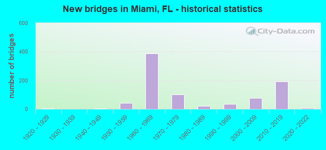
- New bridges - historical statistics
- 11910-1919
- 51920-1929
- 41940-1949
- 421950-1959
- 3861960-1969
- 1011970-1979
- 211980-1989
- 351990-1999
- 762000-2009
- 1932010-2019
- 82020-2022
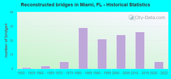
- Reconstructed bridges - Historical Statistics
- 11950-1959
- 21960-1969
- 51970-1979
- 291980-1989
- 211990-1999
- 242000-2009
- 262010-2019
- 52020-2022
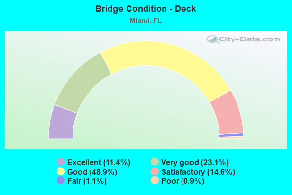
- Bridge Condition - Deck
- 11.4%Excellent
- 23.1%Very good
- 48.9%Good
- 14.6%Satisfactory
- 1.1%Fair
- 0.9%Poor
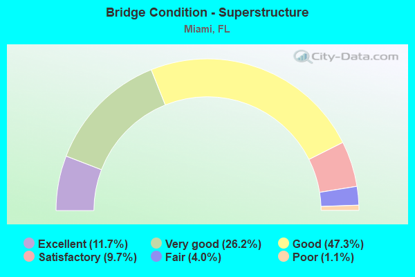
- Bridge Condition - Superstructure
- 11.7%Excellent
- 26.2%Very good
- 47.3%Good
- 9.7%Satisfactory
- 4.0%Fair
- 1.1%Poor
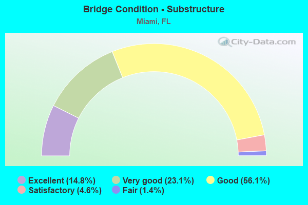
- Bridge Condition - Substructure
- 14.8%Excellent
- 23.1%Very good
- 56.1%Good
- 4.6%Satisfactory
- 1.4%Fair
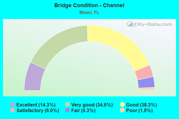
- Bridge Condition - Channel
- 14.3%Excellent
- 34.6%Very good
- 38.3%Good
- 6.0%Satisfactory
- 5.3%Fair
- 1.5%Poor
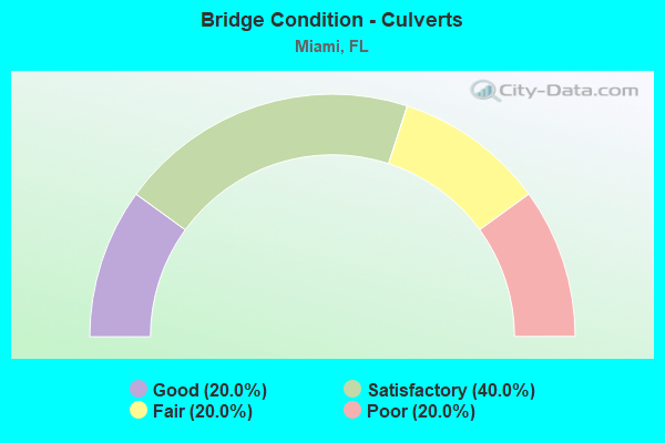
- Bridge Condition - Culverts
- 20.0%Good
- 40.0%Satisfactory
- 20.0%Fair
- 20.0%Poor
Find on map >> Show street view
Structure Number: 870002, Location: 0.13M S OF NE 79 ST (Lat: 25.846542, Lng: -80.184600), Route carried "on" structure: US 5, Year Built: 1928, Year Reconstructed: 1996, Status: Open, Structure Length: 2.62m (8.60ft), Average Daily Traffic: 34,000 (year 2020), Truck Traffic: 4%, Average Future Daily Traffic: 58,990 (year 2042), Design Load: HS 20, Features Intersected: LITTLE RIVER CANAL C-7
Minimum Vertical Clearance: 30+ m (98+ ft), Kilometerpoint: 25.724, Lanes on structure: 4, Owner: State Highway Agency, Approaching Roadway Width: 16.4m (53.8ft), Skew: 20 degrees, Material/Design: Concrete, Design/Construction: Slab, Number Of Spans In Main Unit: 3, Length of Maximum Span: 11.3m (37.1ft), Curb or Sidewalk Widths: Left: 1.8m (5.9ft), Right: 1.8m (5.9ft), Curb-To-Curb Width: 16.4m (53.8ft), Out-to-Out Width: 21.3m (69.9ft)
Condition: Deck: Good, Superstructure: Good, Substructure: Good, Channel: Very good, Operating Rating: 65.4 metric tons, Method Used To Determine Operating Rating: Load Factor (LF), Inventory Rating: 39.3 metric tons, Method Used To Determine Inventory Rating: Load Factor (LF), Structural Evaluation: Better than present minimum criteria, Deck Geometry: Meets minimum limits, Waterway Adequacy: Equal to present desirable criteria, Approach Roadway Alignment: Equal to present desirable criteria, Designated Inspection Frequency: Every 24 months, Underwater Inspection Frequency: Every 24 months, Inspection Date: September 2020, Underwater Inspection Date: September 2020, Deck Structure Type: Concrete Cast-file-Place, Wearing Surface/Protective System: Wearing Surface: Monolithic Concrete
Find on map >> Show street view
Structure Number: 870021, Location: SR112 & I-95 INTERCHANGE (Lat: 25.812600, Lng: -80.206789), Route carried "on" structure: State highway 441, Year Built: 1960, Status: Open, Structure Length: 5.82m (19.09ft), Average Daily Traffic: 21,100 (year 2022), Truck Traffic: 5%, Average Future Daily Traffic: 36,608 (year 2042), Design Load: HS 20, Features Intersected: I-195 (SR-112), Facility Carried by Structure: COMP SR-7
Minimum Vertical Clearance: 4.54m (14.90ft), Kilometerpoint: 5.198, Lanes on structure: 4, Lanes under structure: 4, Base Highway Network: Yes, Owner: State Highway Agency, Approaching Roadway Width: 15.8m (51.8ft), Skew: 2 degrees, Material/Design: Prestressed concrete, Design/Construction: Stringer/Multi-beam, Number Of Spans In Main Unit: 4, Length of Maximum Span: 15.2m (49.9ft), Curb or Sidewalk Widths: Left: 1.4m (4.6ft), Right: 1.4m (4.6ft), Curb-To-Curb Width: 15.8m (51.8ft), Out-to-Out Width: 19.8m (65.0ft)
Condition: Deck: Good, Superstructure: Good, Substructure: Good, Operating Rating: 66.6 metric tons, Method Used To Determine Operating Rating: Load Factor (LF), Inventory Rating: 39.6 metric tons, Method Used To Determine Inventory Rating: Load Factor (LF), Structural Evaluation: Better than present minimum criteria, Deck Geometry: Meets minimum limits, Underclear: High priority of corrective action, Approach Roadway Alignment: Somewhat better than minimum adequacy, Designated Inspection Frequency: Every 24 months, Inspection Date: Febuary 2022, Deck Structure Type: Concrete Cast-file-Place
Find on map >> Show street view
Structure Number: 870022, Location: 0.2 mile E of Toll Plaza (Lat: 25.812500, Lng: -80.215806), Route carried "on" structure: State highway 112, Year Built: 1962, Year Reconstructed: 1989, Status: Open, Structure Length: 5.17m (16.96ft), Average Daily Traffic: 78,500 (year 2020), Truck Traffic: 5%, Average Future Daily Traffic: 136,198 (year 2042), Design Load: HS 20, Features Intersected: SR 933 (NW 12th Ave)
Minimum Vertical Clearance: 30+ m (98+ ft), Kilometerpoint: 6.376, Lanes on structure: 9, Lanes under structure: 6, Toll: On toll road, Owner: State Toll Authority, Approaching Roadway Width: 42.5m (139.4ft), Skew: 30 degrees, Material/Design: Prestressed concrete, Design/Construction: Stringer/Multi-beam, Number Of Spans In Main Unit: 3, Length of Maximum Span: 27.4m (89.9ft), Curb-To-Curb Width: 42.5m (139.4ft), Out-to-Out Width: 44.1m (144.7ft)
Condition: Deck: Satisfactory, Superstructure: Good, Substructure: Good, Operating Rating: 48.6 metric tons, Method Used To Determine Operating Rating: Load Factor (LF), Inventory Rating: 32.7 metric tons, Method Used To Determine Inventory Rating: Load Factor (LF), Structural Evaluation: Better than present minimum criteria, Deck Geometry: Superior to present desirable criteria, Underclear: Somewhat better than minimum adequacy, Approach Roadway Alignment: Equal to present desirable criteria, Designated Inspection Frequency: Every 24 months, Inspection Date: October 2020, Deck Structure Type: Concrete Cast-file-Place
Find on map >> Show street view
Structure Number: 870023, Location: NW 36TH ST INTERCHANGE (Lat: 25.813722, Lng: -80.206806), Route carried "on" structure: US 441, Year Built: 1960, Status: Open, Structure Length: 10.74m (35.24ft), Average Daily Traffic: 21,100 (year 2020), Truck Traffic: 5%, Average Future Daily Traffic: 36,608 (year 2042), Design Load: HS 20, Features Intersected: I-95 RAMP NW 36TH ST, Facility Carried by Structure: COMP SR-7
Minimum Vertical Clearance: 7.31m (23.98ft), Kilometerpoint: 5.319, Lanes on structure: 4, Lanes under structure: 4, Owner: State Highway Agency, Approaching Roadway Width: 15.8m (51.8ft), Skew: 9 degrees, Material/Design: Prestressed concrete, Design/Construction: Stringer/Multi-beam, Number Of Spans In Main Unit: 7, Length of Maximum Span: 19.4m (63.6ft), Curb or Sidewalk Widths: Left: 1.3m (4.3ft), Right: 1.3m (4.3ft), Curb-To-Curb Width: 15.8m (51.8ft), Out-to-Out Width: 19.9m (65.3ft)
Condition: Deck: Satisfactory, Superstructure: Good, Substructure: Good, Operating Rating: 83.8 metric tons, Method Used To Determine Operating Rating: Load Factor (LF), Inventory Rating: 50.3 metric tons, Method Used To Determine Inventory Rating: Load Factor (LF), Structural Evaluation: Better than present minimum criteria, Deck Geometry: Meets minimum limits, Underclear: Meets minimum limits, Approach Roadway Alignment: Equal to present minimum criteria, Designated Inspection Frequency: Every 24 months, Inspection Date: September 2020, Deck Structure Type: Concrete Cast-file-Place
Find on map >> Show street view
Structure Number: 870036, Location: NW 36 St, 200' E NW 72 AV (Lat: 25.808761, Lng: -80.308703), Route carried "on" structure: State highway 948, Year Built: 1964, Year Reconstructed: 1991, Status: Open, Structure Length: 20.27m (66.50ft), Average Daily Traffic: 26,750 (year 2020), Truck Traffic: 10%, Average Future Daily Traffic: 46,411 (year 2042), Design Load: HS 20, Features Intersected: FEC R/R
Minimum Vertical Clearance: 30+ m (98+ ft), Kilometerpoint: 1.389, Lanes on structure: 3, Owner: State Highway Agency, Approaching Roadway Width: 12.8m (42.0ft), Skew: 6 degrees, Material/Design: Prestressed concrete, Design/Construction: Stringer/Multi-beam, Number Of Spans In Main Unit: 8, Length of Maximum Span: 25.9m (85.0ft), Curb or Sidewalk Widths: Left: 2.0m (6.6ft), Right: 0.0m, Curb-To-Curb Width: 12.8m (42.0ft), Out-to-Out Width: 16.7m (54.8ft)
Condition: Deck: Good, Superstructure: Good, Substructure: Good, Channel: Very good, Operating Rating: 56.8 metric tons, Method Used To Determine Operating Rating: Load Factor (LF), Inventory Rating: 31.4 metric tons, Method Used To Determine Inventory Rating: Load Factor (LF), Structural Evaluation: Better than present minimum criteria, Deck Geometry: Meets minimum limits, Underclear: Superior to present desirable criteria, Waterway Adequacy: Equal to present desirable criteria, Approach Roadway Alignment: Equal to present desirable criteria, Designated Inspection Frequency: Every 24 months, Inspection Date: June 2020, Deck Structure Type: Concrete Cast-file-Place, Wearing Surface/Protective System: Wearing Surface: Monolithic Concrete
Find on map >> Show street view
Structure Number: 870043, Location: SR7 SB G. GLADES (Lat: 25.931358, Lng: -80.205131), Route carried "on" structure: US 441, Year Built: 1963, Status: Open, Structure Length: 16.23m (53.25ft), Average Daily Traffic: 20,000 (year 2020), Truck Traffic: 5%, Average Future Daily Traffic: 34,700 (year 2042), Design Load: HS 20, Features Intersected: I-95 RAMP,FEC RR,2ND AVE
Minimum Vertical Clearance: 5.85m (19.19ft), Kilometerpoint: 0.000, Lanes on structure: 2, Lanes under structure: 4, Base Highway Network: Yes (Inventory Route: 871400, Subroute: 1), Owner: State Highway Agency, Approaching Roadway Width: 8.6m (28.2ft), Skew: 5 degrees, Material/Design: Prestressed concrete, Design/Construction: Stringer/Multi-beam, Number Of Spans In Main Unit: 7, Length of Maximum Span: 29.5m (96.8ft), Curb or Sidewalk Widths: Left: 0.3m (1.0ft), Right: 0.3m (1.0ft), Curb-To-Curb Width: 8.6m (28.2ft), Out-to-Out Width: 10.4m (34.1ft)
Condition: Deck: Good, Superstructure: Good, Substructure: Good, Operating Rating: 59.2 metric tons, Method Used To Determine Operating Rating: Load Factor (LF), Inventory Rating: 43.6 metric tons, Method Used To Determine Inventory Rating: Load Factor (LF), Structural Evaluation: Better than present minimum criteria, Deck Geometry: High priority of corrective action, Underclear: High priority of corrective action, Approach Roadway Alignment: Equal to present minimum criteria, Designated Inspection Frequency: Every 24 months, Inspection Date: June 2021, Deck Structure Type: Concrete Cast-file-Place, Wearing Surface/Protective System: Wearing Surface: Integral Concrete
Find on map >> Show street view
Structure Number: 870082, Location: 1.0 mi E of SR-5 (Lat: 25.848014, Lng: -80.171286), Route carried "on" structure: State highway 934, Year Built: 1972, Status: Open, Structure Length: 29.51m (96.82ft), Average Daily Traffic: 20,750 (year 2018), Truck Traffic: 7%, Average Future Daily Traffic: 36,001 (year 2040), Design Load: HS 20, Features Intersected: Intracoastal Waterway, Facility Carried by Structure: NE 79 St. WB
Minimum Vertical Clearance: 30.18m (99.02ft), Kilometerpoint: 1.201, Lanes on structure: 3, Base Highway Network: Yes, Owner: State Highway Agency, Approaching Roadway Width: 12.2m (40.0ft), Navigation Control: Yes ( Vertical Clearance: 6.6m (21.7ft), Horizontal Clearance: 27.4m (89.9ft)), Material/Design: Steel, Design/Construction: Movable - Bascule, Number Of Spans In Main Unit: 1, Number Of Approach Spans: 13, Length of Maximum Span: 45.5m (149.3ft), Curb or Sidewalk Widths: Left: 1.7m (5.6ft), Right: 0.6m (2.0ft), Curb-To-Curb Width: 12.2m (40.0ft), Out-to-Out Width: 14.6m (47.9ft)
Condition: Deck: Satisfactory, Superstructure: Fair, Substructure: Satisfactory, Channel: Very good, Operating Rating: 39.9 metric tons, Method Used To Determine Operating Rating: Load Factor (LF), Inventory Rating: 23.9 metric tons, Method Used To Determine Inventory Rating: Load Factor (LF), Structural Evaluation: Somewhat better than minimum adequacy, Deck Geometry: Meets minimum limits, Waterway Adequacy: Equal to present desirable criteria, Approach Roadway Alignment: Equal to present desirable criteria, Designated Inspection Frequency: Every 24 months, Critical Feature Inspection Frequency: Every 24 months, Underwater Inspection Frequency: Every 24 months, Other Special Inspection Frequency: Every 12 months, Inspection Date: April 2021, Critical Feature Inspection Date: April 2021, Underwater Inspection Date: April 2021, Other Special Inspection Date: April 2021, Total Project Cost: $1,607,000, Deck Structure Type: Concrete Cast-file-Place, Wearing Surface/Protective System: Wearing Surface: Monolithic Concrete
Find on map >> Show street view
Structure Number: 870111, Location: 1.1 mile West of I 95 (Lat: 25.812403, Lng: -80.224000), Route carried "on" structure: State highway 112, Year Built: 1960, Year Reconstructed: 1988, Status: Open, Structure Length: 4.36m (14.30ft), Average Daily Traffic: 37,000 (year 2020), Truck Traffic: 5%, Average Future Daily Traffic: 64,195 (year 2042), Design Load: HS 20, Features Intersected: NW 17th Avenue
Minimum Vertical Clearance: 30+ m (98+ ft), Kilometerpoint: 5.546, Lanes on structure: 5, Lanes under structure: 5, Toll: On toll road, Owner: State Toll Authority, Approaching Roadway Width: 24.4m (80.1ft), Material/Design: Prestressed concrete, Design/Construction: Stringer/Multi-beam, Number Of Spans In Main Unit: 3, Length of Maximum Span: 19.2m (63.0ft), Curb-To-Curb Width: 23.5m (77.1ft), Out-to-Out Width: 24.4m (80.1ft)
Condition: Deck: Good, Superstructure: Good, Substructure: Good, Operating Rating: 36.6 metric tons, Method Used To Determine Operating Rating: Load Factor (LF), Inventory Rating: 32.7 metric tons, Method Used To Determine Inventory Rating: Load Factor (LF), Structural Evaluation: Better than present minimum criteria, Deck Geometry: Equal to present minimum criteria, Underclear: Meets minimum limits, Approach Roadway Alignment: Equal to present desirable criteria, Designated Inspection Frequency: Every 24 months, Inspection Date: October 2020, Deck Structure Type: Concrete Cast-file-Place, Wearing Surface/Protective System: Wearing Surface: Monolithic Concrete
Find on map >> Show street view
Structure Number: 870112, Location: SR-826 & US-41 (Lat: 25.762594, Lng: -80.320850), Route carried "on" structure: State highway 826, Year Built: 1960, Year Reconstructed: 2007, Status: Open, Structure Length: 11.08m (36.35ft), Average Daily Traffic: 119,000 (year 2020), Truck Traffic: 6%, Average Future Daily Traffic: 206,465 (year 2042), Design Load: HL 93, Features Intersected: US-41(SR-90)/ SW 8TH ST
Minimum Vertical Clearance: 30+ m (98+ ft), Kilometerpoint: 9.571, Lanes on structure: 5, Lanes under structure: 6, Base Highway Network: Yes, Owner: State Highway Agency, Approaching Roadway Width: 25.0m (82.0ft), Skew: 1 degrees, Material/Design: Prestressed concrete, Design/Construction: Stringer/Multi-beam, Number Of Spans In Main Unit: 7, Length of Maximum Span: 17.2m (56.4ft), Curb-To-Curb Width: 25.0m (82.0ft), Out-to-Out Width: 25.9m (85.0ft)
Condition: Deck: Good, Superstructure: Good, Substructure: Good, Channel: Good, Operating Rating: 36.9 metric tons, Method Used To Determine Operating Rating: Load and Resistance Factor (LRFR), Inventory Rating: 24.5 metric tons, Method Used To Determine Inventory Rating: Load and Resistance Factor (LRFR), Structural Evaluation: Equal to present minimum criteria, Deck Geometry: Better than present minimum criteria, Underclear: High priority of corrective action, Waterway Adequacy: Equal to present desirable criteria, Approach Roadway Alignment: Equal to present desirable criteria, Designated Inspection Frequency: Every 24 months, Underwater Inspection Frequency: Every 24 months, Inspection Date: May 2020, Underwater Inspection Date: May 2020, Deck Structure Type: Concrete Cast-file-Place, Wearing Surface/Protective System: Wearing Surface: Bituminous
Find on map >> Show street view
Structure Number: 870119, Location: 0.5 mile W of NW 22nd Ave (Lat: 25.812403, Lng: -80.240361), Route carried "on" structure: State highway 112, Year Built: 1960, Status: Open, Structure Length: 5.81m (19.06ft), Average Daily Traffic: 37,000 (year 2020), Truck Traffic: 5%, Average Future Daily Traffic: 64,195 (year 2042), Design Load: HS 20, Features Intersected: SR 9 (NW 27th Avenue)
Minimum Vertical Clearance: 30+ m (98+ ft), Kilometerpoint: 3.907, Lanes on structure: 3, Lanes under structure: 6, Toll: On toll road, Owner: State Toll Authority, Approaching Roadway Width: 12.7m (41.7ft), Material/Design: Prestressed concrete, Design/Construction: Stringer/Multi-beam, Number Of Spans In Main Unit: 3, Length of Maximum Span: 31.9m (104.7ft), Curb-To-Curb Width: 12.1m (39.7ft), Out-to-Out Width: 14.1m (46.3ft)
Condition: Deck: Good, Superstructure: Good, Substructure: Good, Operating Rating: 49.1 metric tons, Method Used To Determine Operating Rating: Load Factor (LF), Inventory Rating: 29.4 metric tons, Method Used To Determine Inventory Rating: Load Factor (LF), Structural Evaluation: Better than present minimum criteria, Deck Geometry: High priority of replacement, Underclear: Equal to present minimum criteria, Approach Roadway Alignment: Equal to present desirable criteria, Designated Inspection Frequency: Every 24 months, Inspection Date: October 2020, Deck Structure Type: Concrete Cast-file-Place, Wearing Surface/Protective System: Wearing Surface: Monolithic Concrete
Find on map >> Show street view
Structure Number: 87012, Location: 1.5 mile W of I-95 (Lat: 25.812194, Lng: -80.232167), Route carried "on" structure: State highway 112, Year Built: 1960, Status: Open, Structure Length: 5.24m (17.19ft), Average Daily Traffic: 37,000 (year 2020), Truck Traffic: 5%, Average Future Daily Traffic: 64,195 (year 2042), Design Load: HS 20, Features Intersected: NW 22nd Avenue
Minimum Vertical Clearance: 30+ m (98+ ft), Kilometerpoint: 4.731, Lanes on structure: 3, Lanes under structure: 6, Toll: On toll road, Owner: State Toll Authority, Approaching Roadway Width: 13.4m (44.0ft), Material/Design: Prestressed concrete, Design/Construction: Stringer/Multi-beam, Number Of Spans In Main Unit: 3, Length of Maximum Span: 27.4m (89.9ft), Curb-To-Curb Width: 12.2m (40.0ft), Out-to-Out Width: 14.3m (46.9ft)
Condition: Deck: Good, Superstructure: Good, Substructure: Good, Operating Rating: 39.4 metric tons, Method Used To Determine Operating Rating: Load and Resistance Factor (LRFR), Inventory Rating: 30.4 metric tons, Method Used To Determine Inventory Rating: Load and Resistance Factor (LRFR), Structural Evaluation: Better than present minimum criteria, Deck Geometry: High priority of replacement, Underclear: Meets minimum limits, Approach Roadway Alignment: Equal to present desirable criteria, Designated Inspection Frequency: Every 24 months, Inspection Date: October 2020, Deck Structure Type: Concrete Cast-file-Place, Wearing Surface/Protective System: Wearing Surface: Monolithic Concrete
Find on map >> Show street view
Structure Number: 870122, Location: 0.2 mile E of SR 953 Exit (Lat: 25.810500, Lng: -80.256556), Route carried "on" structure: State highway 112, Year Built: 1960, Status: Open, Structure Length: 4.80m (15.75ft), Average Daily Traffic: 39,250 (year 2020), Truck Traffic: 8%, Average Future Daily Traffic: 68,099 (year 2042), Design Load: H 20, Features Intersected: NW 37th Avenue
Minimum Vertical Clearance: 30+ m (98+ ft), Kilometerpoint: 2.263, Lanes on structure: 4, Lanes under structure: 2, Base Highway Network: Yes, Toll: On toll road, Owner: State Toll Authority, Approaching Roadway Width: 17.4m (57.1ft), Skew: 2 degrees, Material/Design: Prestressed concrete, Design/Construction: Stringer/Multi-beam, Number Of Spans In Main Unit: 3, Length of Maximum Span: 20.5m (67.3ft), Curb-To-Curb Width: 17.4m (57.1ft), Out-to-Out Width: 22.9m (75.1ft)
Condition: Deck: Good, Superstructure: Good, Substructure: Good, Operating Rating: 44.7 metric tons, Method Used To Determine Operating Rating: Load and Resistance Factor (LRFR), Inventory Rating: 31.7 metric tons, Method Used To Determine Inventory Rating: Load and Resistance Factor (LRFR), Structural Evaluation: Better than present minimum criteria, Deck Geometry: Meets minimum limits, Underclear: Better than present minimum criteria, Approach Roadway Alignment: Equal to present desirable criteria, Designated Inspection Frequency: Every 24 months, Inspection Date: September 2020, Deck Structure Type: Concrete Cast-file-Place
Find on map >> Show street view
Structure Number: 870123, Location: 0.5 mile W of NW 27th Ave (Lat: 25.812250, Lng: -80.248486), Route carried "on" structure: State highway 112, Year Built: 1960, Status: Open, Structure Length: 4.36m (14.30ft), Average Daily Traffic: 39,250 (year 2020), Truck Traffic: 8%, Average Future Daily Traffic: 68,099 (year 2042), Design Load: HS 20, Features Intersected: NW 32nd Avenue
Minimum Vertical Clearance: 30+ m (98+ ft), Kilometerpoint: 3.093, Lanes on structure: 3, Lanes under structure: 5, Toll: On toll road, Owner: State Toll Authority, Approaching Roadway Width: 12.0m (39.4ft), Material/Design: Prestressed concrete, Design/Construction: Stringer/Multi-beam, Number Of Spans In Main Unit: 3, Length of Maximum Span: 19.2m (63.0ft), Curb or Sidewalk Widths: Left: 0.1m (0.3ft), Right: 0.1m (0.3ft), Curb-To-Curb Width: 12.0m (39.4ft), Out-to-Out Width: 14.0m (45.9ft)
Condition: Deck: Good, Superstructure: Good, Substructure: Good, Operating Rating: 53.5 metric tons, Method Used To Determine Operating Rating: Load and Resistance Factor (LRFR), Inventory Rating: 40.8 metric tons, Method Used To Determine Inventory Rating: Load and Resistance Factor (LRFR), Structural Evaluation: Better than present minimum criteria, Deck Geometry: High priority of replacement, Underclear: High priority of corrective action, Approach Roadway Alignment: Equal to present desirable criteria, Designated Inspection Frequency: Every 24 months, Inspection Date: September 2020, Deck Structure Type: Concrete Cast-file-Place
Find on map >> Show street view
Structure Number: 870135, Location: SR 836 over NW 57th Ave (Lat: 25.784250, Lng: -80.288528), Route carried "on" structure: State highway 836, Year Built: 1968, Year Reconstructed: 2018, Status: Open, Structure Length: 5.20m (17.06ft), Average Daily Traffic: 222,500 (year 2021), Truck Traffic: 4%, Average Future Daily Traffic: 255,500 (year 2042), Design Load: HS 20, Features Intersected: NW 57th Ave (Red Rd)
Minimum Vertical Clearance: 30+ m (98+ ft), Kilometerpoint: 14.014, Lanes on structure: 5, Lanes under structure: 6, Base Highway Network: Yes, Toll: On toll road, Owner: State Toll Authority, Approaching Roadway Width: 24.7m (81.0ft), Material/Design: Prestressed concrete, Design/Construction: Stringer/Multi-beam, Number Of Spans In Main Unit: 3, Length of Maximum Span: 28.8m (94.5ft), Curb-To-Curb Width: 24.7m (81.0ft), Out-to-Out Width: 25.8m (84.6ft)
Condition: Deck: Good, Superstructure: Good, Substructure: Very good, Operating Rating: 56.2 metric tons, Method Used To Determine Operating Rating: Load and Resistance Factor (LRFR), Inventory Rating: 35.6 metric tons, Method Used To Determine Inventory Rating: Load and Resistance Factor (LRFR), Structural Evaluation: Better than present minimum criteria, Deck Geometry: Better than present minimum criteria, Underclear: High priority of corrective action, Approach Roadway Alignment: Equal to present desirable criteria, Designated Inspection Frequency: Every 24 months, Inspection Date: May 2021, Deck Structure Type: Concrete Cast-file-Place, Wearing Surface/Protective System: Wearing Surface: Monolithic Concrete
Find on map >> Show street view
Structure Number: 870136, Location: 0.75 mile W of SR 953 (Lat: 25.783767, Lng: -80.274267), Route carried "on" structure: State highway 836, Year Built: 1968, Year Reconstructed: 2018, Status: Open, Structure Length: 7.32m (24.02ft), Average Daily Traffic: 89,500 (year 2021), Truck Traffic: 3%, Average Future Daily Traffic: 155,283 (year 2042), Design Load: HS 20, Features Intersected: Blue Lagoon
Minimum Vertical Clearance: 30+ m (98+ ft), Kilometerpoint: 15.490, Lanes on structure: 6, Base Highway Network: Yes, Toll: On toll road, Owner: State Toll Authority, Approaching Roadway Width: 28.6m (93.8ft), Skew: 2 degrees, Navigation Control: Yes ( Vertical Clearance: 3.1m (10.2ft), Horizontal Clearance: 12.5m (41.0ft)), Material/Design: Prestressed concrete, Design/Construction: Stringer/Multi-beam, Number Of Spans In Main Unit: 5, Length of Maximum Span: 17.7m (58.1ft), Curb-To-Curb Width: 28.6m (93.8ft), Out-to-Out Width: 28.6m (93.8ft)
Condition: Deck: Very good, Superstructure: Very good, Substructure: Very good, Channel: Very good, Operating Rating: 42.8 metric tons, Method Used To Determine Operating Rating: Load Factor (LF), Inventory Rating: 32.7 metric tons, Method Used To Determine Inventory Rating: Load Factor (LF), Structural Evaluation: Equal to present desirable criteria, Deck Geometry: Better than present minimum criteria, Waterway Adequacy: Better than present minimum criteria, Approach Roadway Alignment: Equal to present desirable criteria, Designated Inspection Frequency: Every 24 months, Underwater Inspection Frequency: Every 24 months, Inspection Date: June 2021, Underwater Inspection Date: June 2021, Deck Structure Type: Concrete Cast-file-Place
Find on map >> Show street view
Structure Number: 870137, Location: 0.4 mi west of SR 953 (Lat: 25.783328, Lng: -80.269653), Route carried "on" structure: State highway 836, Year Built: 1968, Year Reconstructed: 2018, Status: Open, Structure Length: 3.83m (12.57ft), Average Daily Traffic: 195,000 (year 2021), Truck Traffic: 3%, Average Future Daily Traffic: 224,000 (year 2042), Design Load: HS 20, Features Intersected: NW 45th Avenue
Minimum Vertical Clearance: 30+ m (98+ ft), Kilometerpoint: 15.963, Lanes on structure: 4, Lanes under structure: 3, Base Highway Network: Yes, Toll: On toll road, Owner: State Toll Authority, Approaching Roadway Width: 20.1m (65.9ft), Material/Design: Prestressed concrete, Design/Construction: Stringer/Multi-beam, Number Of Spans In Main Unit: 3, Length of Maximum Span: 16.3m (53.5ft), Curb-To-Curb Width: 20.1m (65.9ft), Out-to-Out Width: 21.0m (68.9ft)
Condition: Deck: Good, Superstructure: Very good, Substructure: Very good, Operating Rating: 39.2 metric tons, Method Used To Determine Operating Rating: Load Factor (LF), Inventory Rating: 34.3 metric tons, Method Used To Determine Inventory Rating: Load Factor (LF), Structural Evaluation: Equal to present desirable criteria, Deck Geometry: Equal to present minimum criteria, Underclear: Meets minimum limits, Approach Roadway Alignment: Equal to present desirable criteria, Designated Inspection Frequency: Every 24 months, Inspection Date: May 2021, Deck Structure Type: Concrete Cast-file-Place
Find on map >> Show street view
Structure Number: 870138, Location: SR 836/SR 953 Interchange (Lat: 25.785569, Lng: -80.264153), Route carried "on" structure: State highway 836, Year Built: 1969, Year Reconstructed: 2019, Status: Open, Structure Length: 6.49m (21.29ft), Average Daily Traffic: 89,500 (year 2021), Truck Traffic: 3%, Average Future Daily Traffic: 155,283 (year 2042), Design Load: HS 20, Features Intersected: SR 953 (LeJeune Rd)
Minimum Vertical Clearance: 30+ m (98+ ft), Kilometerpoint: 16.571, Lanes on structure: 4, Lanes under structure: 6, Toll: On toll road, Owner: State Toll Authority, Approaching Roadway Width: 18.3m (60.0ft), Skew: 2 degrees, Material/Design: Prestressed concrete, Design/Construction: Stringer/Multi-beam, Number Of Spans In Main Unit: 4, Length of Maximum Span: 23.2m (76.1ft), Curb-To-Curb Width: 18.3m (60.0ft), Out-to-Out Width: 22.9m (75.1ft)
Condition: Deck: Good, Superstructure: Good, Substructure: Good, Operating Rating: 32.0 metric tons, Method Used To Determine Operating Rating: Load Factor (LF), Inventory Rating: 27.4 metric tons, Method Used To Determine Inventory Rating: Load Factor (LF), Structural Evaluation: Equal to present minimum criteria, Deck Geometry: Meets minimum limits, Underclear: Meets minimum limits, Approach Roadway Alignment: Better than present minimum criteria, Designated Inspection Frequency: Every 24 months, Inspection Date: May 2021, Deck Structure Type: Concrete Cast-file-Place, Wearing Surface/Protective System: Wearing Surface: Monolithic Concrete
Find on map >> Show street view
Structure Number: 870139, Location: 0.5 mile E of SR 953 (Lat: 25.786069, Lng: -80.255917), Route carried "on" structure: State highway 836, Year Built: 1968, Year Reconstructed: 2019, Status: Open, Structure Length: 4.91m (16.11ft), Average Daily Traffic: 192,500 (year 2021), Truck Traffic: 4%, Average Future Daily Traffic: 221,500 (year 2042), Design Load: HS 20, Features Intersected: NW 37th Avenue
Minimum Vertical Clearance: 30+ m (98+ ft), Kilometerpoint: 17.400, Lanes on structure: 4, Lanes under structure: 5, Toll: On toll road, Owner: State Toll Authority, Approaching Roadway Width: 21.8m (71.5ft), Material/Design: Prestressed concrete, Design/Construction: Stringer/Multi-beam, Number Of Spans In Main Unit: 3, Length of Maximum Span: 28.3m (92.8ft), Curb or Sidewalk Widths: Left: 0.2m (0.7ft), Right: 0.0m, Curb-To-Curb Width: 21.8m (71.5ft), Out-to-Out Width: 22.7m (74.5ft)
Condition: Deck: Very good, Superstructure: Very good, Substructure: Very good, Operating Rating: 45.4 metric tons, Method Used To Determine Operating Rating: Load Factor (LF), Inventory Rating: 32.7 metric tons, Method Used To Determine Inventory Rating: Load Factor (LF), Structural Evaluation: Equal to present desirable criteria, Deck Geometry: Better than present minimum criteria, Underclear: Equal to present minimum criteria, Approach Roadway Alignment: Equal to present desirable criteria, Designated Inspection Frequency: Every 24 months, Inspection Date: May 2021, Deck Structure Type: Concrete Cast-file-Place
Find on map >> Show street view
Structure Number: 87014, Location: 0.5 mi. E of NW 42nd Ave (Lat: 25.785667, Lng: -80.251347), Route carried "on" structure: State highway 836, Year Built: 1968, Year Reconstructed: 2018, Status: Open, Structure Length: 4.43m (14.53ft), Average Daily Traffic: 61,500 (year 2020), Truck Traffic: 4%, Average Future Daily Traffic: 106,702 (year 2042), Design Load: HS 20, Features Intersected: NW 34th Avenue
Minimum Vertical Clearance: 30+ m (98+ ft), Kilometerpoint: 14.108, Lanes on structure: 4, Lanes under structure: 2, Toll: On toll road, Owner: State Toll Authority, Approaching Roadway Width: 22.9m (75.1ft), Skew: 1 degrees, Material/Design: Prestressed concrete, Design/Construction: Stringer/Multi-beam, Number Of Spans In Main Unit: 3, Length of Maximum Span: 16.8m (55.1ft), Curb or Sidewalk Widths: Left: 1.5m (4.9ft), Right: 1.5m (4.9ft), Curb-To-Curb Width: 22.9m (75.1ft), Out-to-Out Width: 23.0m (75.5ft)
Condition: Deck: Very good, Superstructure: Good, Substructure: Very good, Operating Rating: 32.7 metric tons, Method Used To Determine Operating Rating: Load Factor (LF), Inventory Rating: 19.6 metric tons, Method Used To Determine Inventory Rating: Load Factor (LF), Structural Evaluation: Meets minimum limits, Deck Geometry: Superior to present desirable criteria, Underclear: Meets minimum limits, Approach Roadway Alignment: Equal to present desirable criteria, Designated Inspection Frequency: Every 24 months, Inspection Date: July 2020, Deck Structure Type: Concrete Cast-file-Place
Find on map >> Show street view
Structure Number: 870141, Location: 0.15 mi. W of NW 27th Ave (Lat: 25.784764, Lng: -80.242014), Route carried "on" structure: State highway 836, Year Built: 1968, Year Reconstructed: 2019, Status: Open, Structure Length: 4.39m (14.40ft), Average Daily Traffic: 192,500 (year 2021), Truck Traffic: 4%, Average Future Daily Traffic: 221,500 (year 2042), Design Load: HS 20, Features Intersected: NW 29th Avenue
Minimum Vertical Clearance: 30+ m (98+ ft), Kilometerpoint: 18.815, Lanes on structure: 6, Lanes under structure: 2, Toll: On toll road, Owner: State Toll Authority, Approaching Roadway Width: 30.2m (99.1ft), Material/Design: Prestressed concrete, Design/Construction: Stringer/Multi-beam, Number Of Spans In Main Unit: 3, Length of Maximum Span: 22.4m (73.5ft), Curb-To-Curb Width: 30.2m (99.1ft), Out-to-Out Width: 32.9m (107.9ft)
Condition: Deck: Very good, Superstructure: Very good, Substructure: Very good, Operating Rating: 35.3 metric tons, Method Used To Determine Operating Rating: Load Factor (LF), Inventory Rating: 32.7 metric tons, Method Used To Determine Inventory Rating: Load Factor (LF), Structural Evaluation: Equal to present desirable criteria, Deck Geometry: Superior to present desirable criteria, Underclear: Better than present minimum criteria, Approach Roadway Alignment: Equal to present desirable criteria, Designated Inspection Frequency: Every 24 months, Inspection Date: July 2021, Deck Structure Type: Concrete Cast-file-Place
Find on map >> Show street view
Structure Number: 870142, Location: SR 836/SR 9 Interchange (Lat: 25.784972, Lng: -80.239528), Route carried "on" structure: State highway 836, Year Built: 1969, Year Reconstructed: 2019, Status: Open, Structure Length: 5.50m (18.04ft), Average Daily Traffic: 86,500 (year 2021), Truck Traffic: 3%, Average Future Daily Traffic: 150,078 (year 2042), Design Load: HS 20, Features Intersected: SR 9 (NW 27th Avenue)
Minimum Vertical Clearance: 30+ m (98+ ft), Kilometerpoint: 19.069, Lanes on structure: 4, Lanes under structure: 8, Toll: On toll road, Owner: State Toll Authority, Approaching Roadway Width: 15.2m (49.9ft), Material/Design: Prestressed concrete, Design/Construction: Stringer/Multi-beam, Number Of Spans In Main Unit: 3, Length of Maximum Span: 34.4m (112.9ft), Curb-To-Curb Width: 15.2m (49.9ft), Out-to-Out Width: 22.7m (74.5ft)
Condition: Deck: Good, Superstructure: Good, Substructure: Very good, Operating Rating: 39.2 metric tons, Method Used To Determine Operating Rating: Load Factor (LF), Inventory Rating: 25.1 metric tons, Method Used To Determine Inventory Rating: Load Factor (LF), Structural Evaluation: Equal to present minimum criteria, Deck Geometry: High priority of replacement, Underclear: High priority of corrective action, Approach Roadway Alignment: Equal to present desirable criteria, Designated Inspection Frequency: Every 24 months, Inspection Date: May 2021, Deck Structure Type: Concrete Cast-file-Place, Wearing Surface/Protective System: Wearing Surface: Monolithic Concrete
Find on map >> Show street view
Structure Number: 870143, Location: 0.2miles E of NW 27th Ave (Lat: 25.784722, Lng: -80.237222), Route carried "on" structure: State highway 836, Year Built: 1968, Year Reconstructed: 2019, Status: Open, Structure Length: 0.95m (3.12ft), Average Daily Traffic: 135,000 (year 2021), Truck Traffic: 3%, Average Future Daily Traffic: 234,225 (year 2042), Design Load: HL 93, Features Intersected: Comfort Canal
Minimum Vertical Clearance: 30+ m (98+ ft), Kilometerpoint: 19.307, Lanes on structure: 8, Toll: On toll road, Owner: State Toll Authority, Approaching Roadway Width: 49.0m (160.8ft), Skew: 33 degrees, Material/Design: Concrete, Design/Construction: Slab, Number Of Spans In Main Unit: 1, Length of Maximum Span: 8.7m (28.5ft), Curb-To-Curb Width: 49.0m (160.8ft), Out-to-Out Width: 76.8m (252.0ft)
Condition: Deck: Very good, Superstructure: Very good, Substructure: Good, Channel: Good, Operating Rating: 36.9 metric tons, Method Used To Determine Operating Rating: Load and Resistance Factor (LRFR), Inventory Rating: 28.5 metric tons, Method Used To Determine Inventory Rating: Load and Resistance Factor (LRFR), Structural Evaluation: Better than present minimum criteria, Deck Geometry: Superior to present desirable criteria, Waterway Adequacy: Better than present minimum criteria, Approach Roadway Alignment: Equal to present desirable criteria, Designated Inspection Frequency: Every 24 months, Underwater Inspection Frequency: Every 24 months, Inspection Date: August 2021, Underwater Inspection Date: August 2021, Deck Structure Type: Concrete Cast-file-Place, Wearing Surface/Protective System: Wearing Surface: Bituminous
Find on map >> Show street view
Structure Number: 870144, Location: 0.5 mi. E of SR 9 (Lat: 25.783250, Lng: -80.232778), Route carried "on" structure: State highway 836, Year Built: 1968, Year Reconstructed: 2019, Status: Open, Structure Length: 9.62m (31.56ft), Average Daily Traffic: 68,750 (year 2021), Truck Traffic: 3%, Average Future Daily Traffic: 119,281 (year 2042), Design Load: HL 93, Features Intersected: NW 11th Street
Minimum Vertical Clearance: 30+ m (98+ ft), Kilometerpoint: 19.782, Lanes on structure: 5, Lanes under structure: 4, Toll: On toll road, Owner: State Toll Authority, Approaching Roadway Width: 18.9m (62.0ft), Skew: 6 degrees, Material/Design: Steel, Design/Construction: Stringer/Multi-beam, Number Of Spans In Main Unit: 3, Length of Maximum Span: 40.8m (133.9ft), Curb-To-Curb Width: 18.9m (62.0ft), Out-to-Out Width: 26.6m (87.3ft)
Condition: Deck: Very good, Superstructure: Good, Substructure: Good, Operating Rating: 61.4 metric tons, Method Used To Determine Operating Rating: Load and Resistance Factor (LRFR), Inventory Rating: 47.4 metric tons, Method Used To Determine Inventory Rating: Load and Resistance Factor (LRFR), Structural Evaluation: Better than present minimum criteria, Deck Geometry: High priority of corrective action, Underclear: High priority of corrective action, Approach Roadway Alignment: Equal to present desirable criteria, Designated Inspection Frequency: Every 24 months, Inspection Date: June 2021, Deck Structure Type: Concrete Cast-file-Place
Find on map >> Show street view
Structure Number: 870145, Location: 0.5 mi. E of SR 9 (NW 27) (Lat: 25.782653, Lng: -80.231236), Route carried "on" structure: State highway 836, Year Built: 1968, Year Reconstructed: 2019, Status: Open, Structure Length: 4.65m (15.26ft), Average Daily Traffic: 54,750 (year 2021), Truck Traffic: 4%, Average Future Daily Traffic: 94,991 (year 2042), Design Load: HS 20, Features Intersected: NW 22nd Avenue
Minimum Vertical Clearance: 30+ m (98+ ft), Kilometerpoint: 16.103, Lanes on structure: 5, Lanes under structure: 4, Toll: On toll road, Owner: State Toll Authority, Approaching Roadway Width: 25.6m (84.0ft), Skew: 1 degrees, Material/Design: Prestressed concrete, Design/Construction: Stringer/Multi-beam, Number Of Spans In Main Unit: 3, Length of Maximum Span: 25.5m (83.7ft), Curb-To-Curb Width: 25.6m (84.0ft), Out-to-Out Width: 28.1m (92.2ft)
Condition: Deck: Good, Superstructure: Good, Substructure: Good, Operating Rating: 36.6 metric tons, Method Used To Determine Operating Rating: Load and Resistance Factor (LRFR), Inventory Rating: 32.7 metric tons, Method Used To Determine Inventory Rating: Load and Resistance Factor (LRFR), Structural Evaluation: Better than present minimum criteria, Deck Geometry: Better than present minimum criteria, Underclear: Somewhat better than minimum adequacy, Approach Roadway Alignment: Equal to present desirable criteria, Designated Inspection Frequency: Every 24 months, Inspection Date: May 2021, Deck Structure Type: Concrete Cast-file-Place, Wearing Surface/Protective System: Wearing Surface: Monolithic Concrete
Find on map >> Show street view
Structure Number: 870146, Location: At 17th Avenue WB On Ramp (Lat: 25.782611, Lng: -80.224264), Route carried "on" structure: State highway 836, Year Built: 1968, Year Reconstructed: 2018, Status: Open, Structure Length: 2.35m (7.71ft), Average Daily Traffic: 151,300 (year 2020), Truck Traffic: 4%, Average Future Daily Traffic: 180,500 (year 2042), Design Load: HL 93, Features Intersected: LAWRENCE WATERWAY
Minimum Vertical Clearance: 30+ m (98+ ft), Kilometerpoint: 20.653, Lanes on structure: 4, Toll: On toll road, Owner: State Toll Authority, Approaching Roadway Width: 26.2m (86.0ft), Skew: 1 degrees, Material/Design: Prestressed concrete, Design/Construction: Stringer/Multi-beam, Number Of Spans In Main Unit: 1, Length of Maximum Span: 23.5m (77.1ft), Curb-To-Curb Width: 26.2m (86.0ft), Out-to-Out Width: 30.5m (100.1ft)
Condition: Deck: Very good, Superstructure: Very good, Substructure: Very good, Channel: Very good, Operating Rating: 37.2 metric tons, Method Used To Determine Operating Rating: Load and Resistance Factor (LRFR), Inventory Rating: 33.7 metric tons, Method Used To Determine Inventory Rating: Load and Resistance Factor (LRFR), Structural Evaluation: Equal to present desirable criteria, Deck Geometry: Superior to present desirable criteria, Waterway Adequacy: Equal to present desirable criteria, Approach Roadway Alignment: Equal to present desirable criteria, Designated Inspection Frequency: Every 24 months, Underwater Inspection Frequency: Every 24 months, Inspection Date: December 2020, Underwater Inspection Date: December 2020, Deck Structure Type: Concrete Cast-file-Place
Find on map >> Show street view
Structure Number: 870147, Location: 0.85 miles W of I 95 (Lat: 25.784028, Lng: -80.218583), Route carried "on" structure: State highway 836, Year Built: 1968, Status: Open, Structure Length: 91.00m (298.56ft), Average Daily Traffic: 68,750 (year 2019), Truck Traffic: 3%, Average Future Daily Traffic: 119,281 (year 2041), Design Load: HS 20, Features Intersected: Roads & Miami River
Minimum Vertical Clearance: 30+ m (98+ ft), Kilometerpoint: 21.230, Lanes on structure: 3, Lanes under structure: 20, Toll: On toll road, Owner: State Toll Authority, Approaching Roadway Width: 15.1m (49.5ft), Skew: 4 degrees, Navigation Control: Yes ( Vertical Clearance: 22.8m (74.8ft), Horizontal Clearance: 24.0m (78.7ft)), Material/Design: Steel continuous, Design/Construction: Stringer/Multi-beam, Number Of Spans In Main Unit: 4, Number Of Approach Spans: 26, Length of Maximum Span: 48.6m (159.4ft), Curb or Sidewalk Widths: Left: 0.2m (0.7ft), Right: 0.0m, Curb-To-Curb Width: 13.0m (42.7ft), Out-to-Out Width: 13.0m (42.7ft)
Condition: Deck: Good, Superstructure: Good, Substructure: Good, Channel: Good, Operating Rating: 44.5 metric tons, Method Used To Determine Operating Rating: Load Factor (LF), Inventory Rating: 26.8 metric tons, Method Used To Determine Inventory Rating: Load Factor (LF), Structural Evaluation: Equal to present minimum criteria, Deck Geometry: Meets minimum limits, Underclear: High priority of corrective action, Waterway Adequacy: Superior to present desirable criteria, Approach Roadway Alignment: Equal to present desirable criteria, Designated Inspection Frequency: Every 24 months, Underwater Inspection Frequency: Every 24 months, Inspection Date: December 2021, Underwater Inspection Date: December 2021, Deck Structure Type: Concrete Cast-file-Place
Find on map >> Show street view
Structure Number: 870149, Location: 1.0 mile E of Toll Plaza (Lat: 25.786194, Lng: -80.213194), Route carried "on" structure: State highway 836, Year Built: 1967, Status: Open, Structure Length: 1.52m (4.99ft), Average Daily Traffic: 11,000 (year 2021), Truck Traffic: 6%, Average Future Daily Traffic: 19,085 (year 2042), Design Load: HS 20+Mod, Features Intersected: Wagner Creek Canal
Minimum Vertical Clearance: 30+ m (98+ ft), Kilometerpoint: 0.006, Lanes on structure: 9, Toll: On toll road, Owner: State Toll Authority, Approaching Roadway Width: 50.9m (167.0ft), Skew: 30 degrees, Material/Design: Concrete, Design/Construction: Culvert, Number Of Spans In Main Unit: 2, Length of Maximum Span: 4.0m (13.1ft), Curb-To-Curb Width: 51.0m (167.3ft), Out-to-Out Width: 66.8m (219.2ft)
Condition: Channel: Good, Culverts: Fair, Operating Rating: 60.1 metric tons, Method Used To Determine Operating Rating: Load Factor (LF), Inventory Rating: 36.0 metric tons, Method Used To Determine Inventory Rating: Load Factor (LF), Structural Evaluation: Somewhat better than minimum adequacy, Deck Geometry: Superior to present desirable criteria, Waterway Adequacy: Equal to present minimum criteria, Approach Roadway Alignment: Equal to present desirable criteria, Designated Inspection Frequency: Every 24 months, Underwater Inspection Frequency: Every 24 months, Inspection Date: October 2021, Underwater Inspection Date: October 2021
Find on map >> Show street view
Structure Number: 87015, Location: 0.3 miles West of I 95 (Lat: 25.787569, Lng: -80.210500), Route carried "on" structure: State highway 836, Year Built: 1967, Status: Open, Structure Length: 20.14m (66.08ft), Average Daily Traffic: 69,141 (year 2021), Truck Traffic: 3%, Average Future Daily Traffic: 117,841 (year 2042), Design Load: HS 20, Features Intersected: NW 10th Ave and NW 14 St
Minimum Vertical Clearance: 30+ m (98+ ft), Kilometerpoint: 22.164, Lanes on structure: 5, Lanes under structure: 4, Toll: On toll road, Owner: State Toll Authority, Approaching Roadway Width: 23.1m (75.8ft), Skew: 2 degrees, Material/Design: Steel, Design/Construction: Stringer/Multi-beam, Number Of Spans In Main Unit: 3, Number Of Approach Spans: 4, Length of Maximum Span: 49.0m (160.8ft), Curb-To-Curb Width: 22.4m (73.5ft), Out-to-Out Width: 23.7m (77.8ft)
Condition: Deck: Good, Superstructure: Good, Substructure: Good, Operating Rating: 40.5 metric tons, Method Used To Determine Operating Rating: Load and Resistance Factor (LRFR), Inventory Rating: 30.7 metric tons, Method Used To Determine Inventory Rating: Load and Resistance Factor (LRFR), Structural Evaluation: Better than present minimum criteria, Deck Geometry: Meets minimum limits, Underclear: Meets minimum limits, Approach Roadway Alignment: Equal to present desirable criteria, Designated Inspection Frequency: Every 24 months, Inspection Date: June 2021, Deck Structure Type: Concrete Cast-file-Place
Find on map >> Show street view
Structure Number: 870154, Location: 1.3 MI S OF SR-836 (Lat: 25.763558, Lng: -80.319036), Route carried "on" structure: Ramp State highway 826, Year Built: 1960, Year Reconstructed: 2007, Status: Open, Structure Length: 3.81m (12.50ft), Average Daily Traffic: 6,300 (year 2020), Truck Traffic: 6%, Average Future Daily Traffic: 10,930 (year 2042), Design Load: HL 93, Features Intersected: TAMIAMI CANAL C-4
Minimum Vertical Clearance: 30+ m (98+ ft), Kilometerpoint: 0.093, Lanes on structure: 1, Owner: State Highway Agency, Approaching Roadway Width: 8.3m (27.2ft), Material/Design: Concrete, Design/Construction: Slab, Number Of Spans In Main Unit: 5, Length of Maximum Span: 7.7m (25.3ft), Curb-To-Curb Width: 8.3m (27.2ft), Out-to-Out Width: 9.2m (30.2ft)
Condition: Deck: Good, Superstructure: Good, Substructure: Good, Channel: Good, Operating Rating: 32.0 metric tons, Method Used To Determine Operating Rating: Load and Resistance Factor (LRFR), Inventory Rating: 24.5 metric tons, Method Used To Determine Inventory Rating: Load and Resistance Factor (LRFR), Structural Evaluation: Equal to present minimum criteria, Deck Geometry: Superior to present desirable criteria, Waterway Adequacy: Better than present minimum criteria, Approach Roadway Alignment: Better than present minimum criteria, Designated Inspection Frequency: Every 24 months, Underwater Inspection Frequency: Every 24 months, Inspection Date: May 2020, Underwater Inspection Date: May 2020, Deck Structure Type: Concrete Cast-file-Place
Find on map >> Show street view
Structure Number: 870162, Location: W END RICKENBACKER CSWY (Lat: 25.751217, Lng: -80.204150), Route carried "on" structure: Ramp State highway 913, Year Built: 1970, Status: Open, Structure Length: 39.90m (130.91ft), Average Daily Traffic: 8,600 (year 2020), Truck Traffic: 6%, Average Future Daily Traffic: 14,921 (year 2042), Design Load: HS 20, Features Intersected: US1&S MIAMI AVE&SW 25 RD
Minimum Vertical Clearance: 30+ m (98+ ft), Kilometerpoint: 0.117, Lanes on structure: 2, Lanes under structure: 17, Owner: State Highway Agency, Approaching Roadway Width: 9.8m (32.2ft), Skew: 9 degrees, Material/Design: Steel continuous, Design/Construction: Stringer/Multi-beam, Number Of Spans In Main Unit: 6, Number Of Approach Spans: 5, Length of Maximum Span: 48.8m (160.1ft), Curb-To-Curb Width: 7.3m (24.0ft), Out-to-Out Width: 8.3m (27.2ft)
Condition: Deck: Satisfactory, Superstructure: Satisfactory, Substructure: Good, Operating Rating: 77.0 metric tons, Method Used To Determine Operating Rating: Load Factor (LF), Inventory Rating: 46.2 metric tons, Method Used To Determine Inventory Rating: Load Factor (LF), Structural Evaluation: Equal to present minimum criteria, Deck Geometry: High priority of replacement, Underclear: Equal to present minimum criteria, Approach Roadway Alignment: Equal to present minimum criteria, Designated Inspection Frequency: Every 24 months, Inspection Date: March 2021, Deck Structure Type: Concrete Cast-file-Place
Find on map >> Show street view
Structure Number: 870163, Location: S MIAMI AVE & SW 26 RD (Lat: 25.751550, Lng: -80.204822), Route carried "on" structure: Ramp State highway 913, Year Built: 1970, Status: Open, Structure Length: 8.38m (27.49ft), Average Daily Traffic: 3,800 (year 2020), Truck Traffic: 6%, Average Future Daily Traffic: 6,593 (year 2042), Design Load: HS 20, Features Intersected: S MIAMI AVE & SW 26TH RD
Minimum Vertical Clearance: 30.45m (99.90ft), Kilometerpoint: 0.000, Lanes on structure: 1, Lanes under structure: 11, Owner: State Highway Agency, Approaching Roadway Width: 7.4m (24.3ft), Skew: 9 degrees, Material/Design: Steel continuous, Design/Construction: Stringer/Multi-beam, Number Of Spans In Main Unit: 2, Length of Maximum Span: 48.8m (160.1ft), Curb-To-Curb Width: 7.4m (24.3ft), Out-to-Out Width: 8.4m (27.6ft)
Condition: Deck: Good, Superstructure: Good, Substructure: Good, Operating Rating: 77.0 metric tons, Method Used To Determine Operating Rating: Load Factor (LF), Inventory Rating: 46.2 metric tons, Method Used To Determine Inventory Rating: Load Factor (LF), Structural Evaluation: Better than present minimum criteria, Deck Geometry: Better than present minimum criteria, Underclear: High priority of corrective action, Approach Roadway Alignment: Equal to present desirable criteria, Designated Inspection Frequency: Every 24 months, Inspection Date: April 2020, Deck Structure Type: Concrete Cast-file-Place
Find on map >> Show street view
Structure Number: 870164, Location: 0.88M W OF NW 7 AVE (Lat: 25.972222, Lng: -80.229686), Route carried "on" structure: State highway 852, Year Built: 1972, Status: Open, Structure Length: 6.83m (22.41ft), Average Daily Traffic: 26,500 (year 2020), Truck Traffic: 2%, Average Future Daily Traffic: 45,978 (year 2042), Design Load: HS 20, Features Intersected: FLORIDA TURNPIKE (SR-91)
Minimum Vertical Clearance: 30+ m (98+ ft), Kilometerpoint: 1.693, Lanes on structure: 5, Lanes under structure: 8, Owner: State Highway Agency, Approaching Roadway Width: 28.3m (92.8ft), Skew: 10 degrees, Material/Design: Prestressed concrete, Design/Construction: Stringer/Multi-beam, Number Of Spans In Main Unit: 4, Length of Maximum Span: 25.0m (82.0ft), Curb or Sidewalk Widths: Left: 1.5m (4.9ft), Right: 0.0m, Curb-To-Curb Width: 23.6m (77.4ft), Out-to-Out Width: 30.3m (99.4ft)
Condition: Deck: Good, Superstructure: Good, Substructure: Good, Operating Rating: 59.1 metric tons, Method Used To Determine Operating Rating: Load Factor (LF), Inventory Rating: 35.4 metric tons, Method Used To Determine Inventory Rating: Load Factor (LF), Structural Evaluation: Better than present minimum criteria, Deck Geometry: Better than present minimum criteria, Underclear: Equal to present minimum criteria, Approach Roadway Alignment: Equal to present desirable criteria, Designated Inspection Frequency: Every 24 months, Inspection Date: July 2021, Deck Structure Type: Concrete Cast-file-Place, Wearing Surface/Protective System: Wearing Surface: Monolithic Concrete
Find on map >> Show street view
Structure Number: 870165, Location: At SR 933 (NW 12th Ave) (Lat: 25.785247, Lng: -80.214811), Route carried "on" structure: Ramp State highway 836, Year Built: 1967, Status: Open, Structure Length: 5.52m (18.11ft), Average Daily Traffic: 9,309 (year 2021), Truck Traffic: 11%, Average Future Daily Traffic: 10,109 (year 2042), Design Load: HS 20, Features Intersected: SR 933 (NW 12th Avenue)
Minimum Vertical Clearance: 30+ m (98+ ft), Kilometerpoint: 21.654, Lanes on structure: 1, Lanes under structure: 6, Toll: On toll road, Owner: State Toll Authority, Approaching Roadway Width: 6.2m (20.3ft), Skew: 1 degrees, Material/Design: Prestressed concrete, Design/Construction: Stringer/Multi-beam, Number Of Spans In Main Unit: 3, Length of Maximum Span: 34.2m (112.2ft), Curb or Sidewalk Widths: Left: 0.6m (2.0ft), Right: 0.6m (2.0ft), Curb-To-Curb Width: 6.2m (20.3ft), Out-to-Out Width: 7.3m (24.0ft)
Condition: Deck: Good, Superstructure: Very good, Substructure: Very good, Operating Rating: 51.9 metric tons, Method Used To Determine Operating Rating: Load Factor (LF), Inventory Rating: 30.5 metric tons, Method Used To Determine Inventory Rating: Load Factor (LF), Structural Evaluation: Better than present minimum criteria, Deck Geometry: Somewhat better than minimum adequacy, Underclear: Meets minimum limits, Approach Roadway Alignment: Equal to present desirable criteria, Designated Inspection Frequency: Every 24 months, Inspection Date: June 2021, Deck Structure Type: Concrete Cast-file-Place, Wearing Surface/Protective System: Wearing Surface: Monolithic Concrete
Find on map >> Show street view
Structure Number: 870166, Location: IVES DAIRY ROAD (Lat: 25.964003, Lng: -80.165725), Route carried "on" structure: State highway 854, Year Built: 1970, Year Reconstructed: 1994, Status: Open, Structure Length: 8.69m (28.51ft), Average Daily Traffic: 36,000 (year 2020), Truck Traffic: 11%, Average Future Daily Traffic: 62,460 (year 2042), Design Load: HS 20, Features Intersected: I-95 (SR-9A)
Minimum Vertical Clearance: 30+ m (98+ ft), Kilometerpoint: 4.247, Lanes on structure: 9, Lanes under structure: 9, Owner: State Highway Agency, Approaching Roadway Width: 36.1m (118.4ft), Skew: 20 degrees, Material/Design: Prestressed concrete, Design/Construction: Stringer/Multi-beam, Number Of Spans In Main Unit: 4, Length of Maximum Span: 30.8m (101.0ft), Curb or Sidewalk Widths: Left: 2.0m (6.6ft), Right: 2.0m (6.6ft), Curb-To-Curb Width: 36.1m (118.4ft), Out-to-Out Width: 42.7m (140.1ft)
Condition: Deck: Good, Superstructure: Good, Substructure: Good, Operating Rating: 48.9 metric tons, Method Used To Determine Operating Rating: Load Factor (LF), Inventory Rating: 29.2 metric tons, Method Used To Determine Inventory Rating: Load Factor (LF), Structural Evaluation: Better than present minimum criteria, Deck Geometry: Somewhat better than minimum adequacy, Underclear: Somewhat better than minimum adequacy, Approach Roadway Alignment: Equal to present desirable criteria, Designated Inspection Frequency: Every 24 months, Inspection Date: March 2020, Deck Structure Type: Concrete Cast-file-Place, Wearing Surface/Protective System: Wearing Surface: Bituminous
Find on map >> Show street view
Structure Number: 870215, Location: 14.3 MILES NORTH OF US 1 (Lat: 25.782264, Lng: -80.386011), Route carried "on" structure: State highway 821, Year Built: 1973, Year Reconstructed: 2004, Status: Open, Structure Length: 12.76m (41.86ft), Average Daily Traffic: 52,500 (year 2020), Truck Traffic: 8%, Average Future Daily Traffic: 91,088 (year 2042), Design Load: HS 20+Mod, Features Intersected: SR 836, NW 12ST,CANAL,RR
Minimum Vertical Clearance: 30+ m (98+ ft), Kilometerpoint: 43.750, Lanes on structure: 3, Lanes under structure: 10, Base Highway Network: Yes, Toll: On toll road, Owner: State Toll Authority, Approaching Roadway Width: 17.9m (58.7ft), Material/Design: Prestressed concrete, Design/Construction: Stringer/Multi-beam, Number Of Spans In Main Unit: 5, Length of Maximum Span: 32.8m (107.6ft), Curb-To-Curb Width: 17.5m (57.4ft), Out-to-Out Width: 18.7m (61.4ft)
Condition: Deck: Good, Superstructure: Good, Substructure: Good, Channel: Good, Operating Rating: 62.4 metric tons, Method Used To Determine Operating Rating: Load Factor (LF), Inventory Rating: 38.6 metric tons, Method Used To Determine Inventory Rating: Load Factor (LF), Structural Evaluation: Better than present minimum criteria, Deck Geometry: Better than present minimum criteria, Underclear: High priority of corrective action, Waterway Adequacy: Equal to present desirable criteria, Approach Roadway Alignment: Equal to present desirable criteria, Designated Inspection Frequency: Every 24 months, Inspection Date: April 2020, Deck Structure Type: Concrete Cast-file-Place
Find on map >> Show street view
Structure Number: 870216, Location: 15.3 MILES NORTH OF US-1 (Lat: 25.796903, Lng: -80.386125), Route carried "on" structure: State highway 821, Year Built: 1974, Year Reconstructed: 2001, Status: Open, Structure Length: 7.41m (24.31ft), Average Daily Traffic: 52,500 (year 2020), Truck Traffic: 8%, Average Future Daily Traffic: 91,088 (year 2042), Design Load: HS 20, Features Intersected: NW 25 ST & N LINE CANAL
Minimum Vertical Clearance: 30+ m (98+ ft), Kilometerpoint: 45.401, Lanes on structure: 4, Lanes under structure: 5, Base Highway Network: Yes, Toll: On toll road, Owner: State Toll Authority, Approaching Roadway Width: 21.0m (68.9ft), Material/Design: Prestressed concrete, Design/Construction: Stringer/Multi-beam, Number Of Spans In Main Unit: 3, Length of Maximum Span: 31.4m (103.0ft), Curb-To-Curb Width: 20.4m (66.9ft), Out-to-Out Width: 21.3m (69.9ft)
Condition: Deck: Good, Superstructure: Good, Substructure: Good, Channel: Very good, Operating Rating: 53.2 metric tons, Method Used To Determine Operating Rating: Load Factor (LF), Inventory Rating: 33.0 metric tons, Method Used To Determine Inventory Rating: Load Factor (LF), Structural Evaluation: Better than present minimum criteria, Deck Geometry: Equal to present minimum criteria, Underclear: Superior to present desirable criteria, Waterway Adequacy: Equal to present desirable criteria, Approach Roadway Alignment: Equal to present desirable criteria, Designated Inspection Frequency: Every 24 months, Inspection Date: April 2020, Deck Structure Type: Concrete Cast-file-Place
Find on map >> Show street view
Structure Number: 870217, Location: 16.3 MILES NORTH OF US-1 (Lat: 25.811736, Lng: -80.386531), Route carried "on" structure: State highway 821, Year Built: 1973, Year Reconstructed: 2001, Status: Open, Structure Length: 5.21m (17.09ft), Average Daily Traffic: 50,400 (year 2020), Truck Traffic: 8%, Average Future Daily Traffic: 87,444 (year 2042), Design Load: HS 20, Features Intersected: NW 41 ST
Minimum Vertical Clearance: 30+ m (98+ ft), Kilometerpoint: 47.059, Lanes on structure: 3, Lanes under structure: 5, Base Highway Network: Yes, Toll: On toll road, Owner: State Toll Authority, Approaching Roadway Width: 17.1m (56.1ft), Material/Design: Prestressed concrete, Design/Construction: Stringer/Multi-beam, Number Of Spans In Main Unit: 2, Length of Maximum Span: 26.0m (85.3ft), Curb-To-Curb Width: 16.8m (55.1ft), Out-to-Out Width: 18.0m (59.1ft)
Condition: Deck: Good, Superstructure: Satisfactory, Substructure: Good, Operating Rating: 62.3 metric tons, Method Used To Determine Operating Rating: Load Factor (LF), Inventory Rating: 38.8 metric tons, Method Used To Determine Inventory Rating: Load Factor (LF), Structural Evaluation: Equal to present minimum criteria, Deck Geometry: Equal to present minimum criteria, Underclear: Somewhat better than minimum adequacy, Approach Roadway Alignment: Equal to present desirable criteria, Designated Inspection Frequency: Every 24 months, Inspection Date: April 2020, Deck Structure Type: Concrete Cast-file-Place
Find on map >> Show street view
Structure Number: 870236, Location: NW 36 St, 200' E NW 72 AV (Lat: 25.808628, Lng: -80.308703), Route carried "on" structure: State highway 948, Year Built: 1964, Year Reconstructed: 1991, Status: Open, Structure Length: 20.27m (66.50ft), Average Daily Traffic: 26,750 (year 2020), Truck Traffic: 10%, Average Future Daily Traffic: 46,411 (year 2042), Design Load: HS 20, Features Intersected: FEC R/R
Minimum Vertical Clearance: 30+ m (98+ ft), Kilometerpoint: 1.389, Lanes on structure: 3, Owner: State Highway Agency, Approaching Roadway Width: 12.8m (42.0ft), Skew: 6 degrees, Material/Design: Prestressed concrete, Design/Construction: Stringer/Multi-beam, Number Of Spans In Main Unit: 8, Length of Maximum Span: 25.9m (85.0ft), Curb-To-Curb Width: 12.8m (42.0ft), Out-to-Out Width: 13.7m (44.9ft)
Condition: Deck: Good, Superstructure: Good, Substructure: Good, Channel: Very good, Operating Rating: 62.6 metric tons, Method Used To Determine Operating Rating: Load Factor (LF), Inventory Rating: 33.3 metric tons, Method Used To Determine Inventory Rating: Load Factor (LF), Structural Evaluation: Better than present minimum criteria, Deck Geometry: Meets minimum limits, Underclear: Superior to present desirable criteria, Waterway Adequacy: Equal to present desirable criteria, Approach Roadway Alignment: Equal to present desirable criteria, Designated Inspection Frequency: Every 24 months, Inspection Date: June 2020, Deck Structure Type: Concrete Cast-file-Place, Wearing Surface/Protective System: Wearing Surface: Monolithic Concrete
Find on map >> Show street view
Structure Number: 870238, Location: SR 112 over US 27 (Lat: 25.809083, Lng: -80.259444), Route carried "on" structure: State highway 112, Year Built: 1961, Status: Open, Structure Length: 30.88m (101.31ft), Average Daily Traffic: 56,500 (year 2021), Truck Traffic: 6%, Average Future Daily Traffic: 98,028 (year 2042), Design Load: HL 93, Features Intersected: WB SR 112 / US 27 / RR
Minimum Vertical Clearance: 30+ m (98+ ft), Kilometerpoint: 1.934, Lanes on structure: 3, Lanes under structure: 9, Base Highway Network: Yes, Owner: State Toll Authority, Approaching Roadway Width: 15.8m (51.8ft), Skew: 9 degrees, Material/Design: Steel, Design/Construction: Stringer/Multi-beam, Number Of Spans In Main Unit: 12, Length of Maximum Span: 31.7m (104.0ft), Curb-To-Curb Width: 12.2m (40.0ft), Out-to-Out Width: 15.1m (49.5ft)
Condition: Deck: Good, Superstructure: Satisfactory, Substructure: Good, Operating Rating: 42.5 metric tons, Method Used To Determine Operating Rating: Load and Resistance Factor (LRFR), Inventory Rating: 32.7 metric tons, Method Used To Determine Inventory Rating: Load and Resistance Factor (LRFR), Structural Evaluation: Equal to present minimum criteria, Deck Geometry: High priority of corrective action, Underclear: High priority of corrective action, Approach Roadway Alignment: Equal to present desirable criteria, Designated Inspection Frequency: Every 24 months, Critical Feature Inspection Frequency: Every 24 months, Inspection Date: March 2021, Critical Feature Inspection Date: March 2021, Deck Structure Type: Concrete Cast-file-Place, Wearing Surface/Protective System: Wearing Surface: Monolithic Concrete
Find on map >> Show street view
Structure Number: 870266, Location: 1.1 mile West of I 95 (Lat: 25.812222, Lng: -80.224000), Route carried "on" structure: State highway 112, Year Built: 1960, Year Reconstructed: 1988, Status: Open, Structure Length: 4.36m (14.30ft), Average Daily Traffic: 37,000 (year 2020), Truck Traffic: 5%, Average Future Daily Traffic: 64,195 (year 2042), Design Load: HS 20, Features Intersected: NW 17th Avenue
Minimum Vertical Clearance: 30+ m (98+ ft), Kilometerpoint: 5.546, Lanes on structure: 3, Lanes under structure: 4, Toll: On toll road, Owner: State Toll Authority, Approaching Roadway Width: 15.2m (49.9ft), Material/Design: Prestressed concrete, Design/Construction: Stringer/Multi-beam, Number Of Spans In Main Unit: 3, Length of Maximum Span: 19.2m (63.0ft), Curb-To-Curb Width: 14.0m (45.9ft), Out-to-Out Width: 15.2m (49.9ft)
Condition: Deck: Good, Superstructure: Very good, Substructure: Very good, Operating Rating: 43.7 metric tons, Method Used To Determine Operating Rating: Load and Resistance Factor (LRFR), Inventory Rating: 33.9 metric tons, Method Used To Determine Inventory Rating: Load and Resistance Factor (LRFR), Structural Evaluation: Equal to present desirable criteria, Deck Geometry: Meets minimum limits, Underclear: Somewhat better than minimum adequacy, Approach Roadway Alignment: Equal to present desirable criteria, Designated Inspection Frequency: Every 24 months, Inspection Date: October 2020, Deck Structure Type: Concrete Cast-file-Place, Wearing Surface/Protective System: Wearing Surface: Monolithic Concrete