Bridge Statistics for Mesa, Arizona (AZ)
Condition, Traffic, Stress, Structural Evaluation, Project Costs
- National Bridge Inventory (NBI) Statistics
- 358Number of bridges
- 5,266ft / 1,605mTotal length
- $156,000Total costs
- 16,469,060Total average daily traffic
- 1,063,193Total average daily truck traffic
- National Bridge Inventory (NBI) Registered Bridges for Mesa
- No street view available for this location
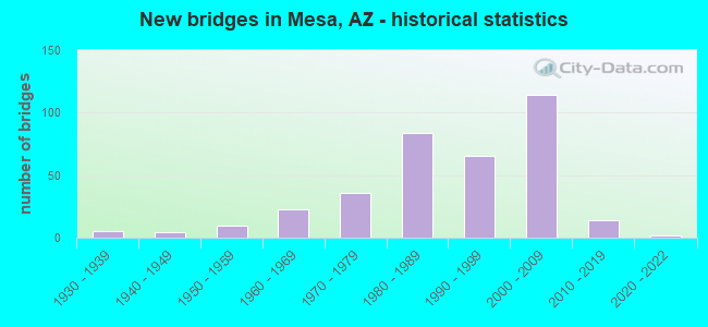
- New bridges - historical statistics
- 11920-1929
- 51930-1939
- 41940-1949
- 101950-1959
- 231960-1969
- 361970-1979
- 841980-1989
- 651990-1999
- 1142000-2009
- 142010-2019
- 22020-2022
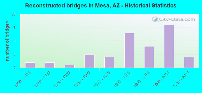
- Reconstructed bridges - Historical Statistics
- 21930-1939
- 21940-1949
- 11950-1959
- 51960-1969
- 41970-1979
- 131980-1989
- 81990-1999
- 162000-2009
- 42010-2019
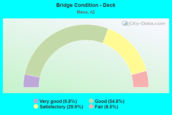
- Bridge Condition - Deck
- 6.8%Very good
- 54.8%Good
- 29.9%Satisfactory
- 8.5%Fair
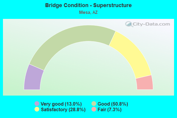
- Bridge Condition - Superstructure
- 13.0%Very good
- 50.8%Good
- 28.8%Satisfactory
- 7.3%Fair
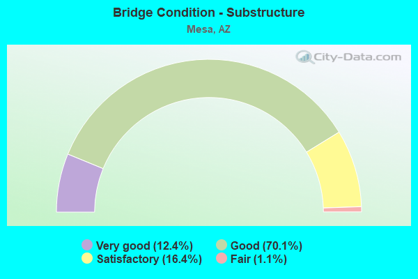
- Bridge Condition - Substructure
- 12.4%Very good
- 70.1%Good
- 16.4%Satisfactory
- 1.1%Fair
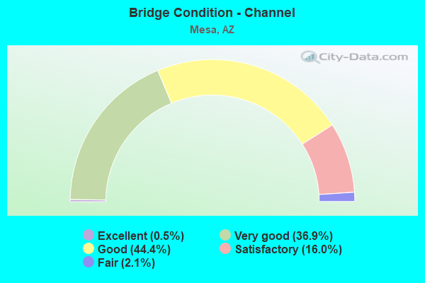
- Bridge Condition - Channel
- 0.5%Excellent
- 36.9%Very good
- 44.4%Good
- 16.0%Satisfactory
- 2.1%Fair
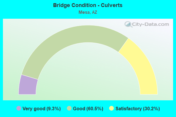
- Bridge Condition - Culverts
- 9.3%Very good
- 60.5%Good
- 30.2%Satisfactory
Find on map >> Show street view
Structure Number: 271, Location: 1.8 mi E Jct SR 74 (Lat: 33.844872, Lng: -112.613514), Route carried "on" structure: US 60, Year Built: 1942, Status: Open, Structure Length: 4.21m (13.81ft), Average Daily Traffic: 7,676 (year 2018), Truck Traffic: 16%, Average Future Daily Traffic: 7,686 (year 2038), Design Load: HS 20, Features Intersected: ATSF Railroad
Minimum Vertical Clearance: 30+ m (98+ ft), Kilometerpoint: 196.195, Lanes on structure: 2, Owner: State Highway Agency, Approaching Roadway Width: 12.2m (40.0ft), Skew: 4 degrees, Material/Design: Concrete, Design/Construction: Tee Beam, Number Of Spans In Main Unit: 3, Length of Maximum Span: 13.7m (44.9ft), Curb-To-Curb Width: 10.4m (34.1ft), Out-to-Out Width: 11.2m (36.7ft)
Condition: Deck: Satisfactory, Superstructure: Satisfactory, Substructure: Satisfactory, Operating Rating: 51.7 metric tons, Method Used To Determine Operating Rating: Load Factor (LF), Inventory Rating: 30.8 metric tons, Method Used To Determine Inventory Rating: Load Factor (LF), Structural Evaluation: Equal to present minimum criteria, Deck Geometry: Somewhat better than minimum adequacy, Underclear: Meets minimum limits, Approach Roadway Alignment: Equal to present minimum criteria, Designated Inspection Frequency: Every 24 months, Inspection Date: November 2021, Deck Structure Type: Concrete Cast-file-Place, Wearing Surface/Protective System: Wearing Surface: Bituminous
Find on map >> Show street view
Structure Number: 281, Location: 18 mi N Jct I-10 (Lat: 32.991500, Lng: -111.524000), Route carried "on" structure: State highway 87, Year Built: 1928, Year Reconstructed: 1963, Status: Open, Structure Length: 1.34m (4.40ft), Average Daily Traffic: 15,627 (year 2019), Truck Traffic: 5%, Average Future Daily Traffic: 15,637 (year 2039), Design Load: HS 20, Features Intersected: Pima Lateral Canal
Minimum Vertical Clearance: 9.14m (29.99ft), Kilometerpoint: 215.620, Lanes on structure: 4, Owner: State Highway Agency, Approaching Roadway Width: 19.5m (64.0ft), Material/Design: Concrete, Design/Construction: Slab, Number Of Spans In Main Unit: 2, Length of Maximum Span: 6.7m (22.0ft), Curb or Sidewalk Widths: Left: 1.5m (4.9ft), Right: 1.5m (4.9ft), Curb-To-Curb Width: 19.5m (64.0ft), Out-to-Out Width: 23.3m (76.4ft)
Condition: Deck: Good, Superstructure: Good, Substructure: Satisfactory, Channel: Very good, Operating Rating: 40.8 metric tons, Method Used To Determine Operating Rating: Load Factor (LF), Inventory Rating: 24.5 metric tons, Method Used To Determine Inventory Rating: Load Factor (LF), Structural Evaluation: Equal to present minimum criteria, Deck Geometry: Better than present minimum criteria, Waterway Adequacy: Better than present minimum criteria, Approach Roadway Alignment: Equal to present desirable criteria, Length Of Structure Improvement: 2.10m (6.89ft), Designated Inspection Frequency: Every 24 months, Inspection Date: January 2022, Total Project Cost: $1,000 ( Estimate for 2022), Deck Structure Type: Concrete Cast-file-Place, Wearing Surface/Protective System: Wearing Surface: Bituminous
Find on map >> Show street view
Structure Number: 283, Location: 14.9 mi N Jct SR 260 (Lat: 34.383500, Lng: -111.453800), Route carried "on" structure: State highway 87, Year Built: 1946, Year Reconstructed: 1986, Status: Open, Structure Length: 1.71m (5.61ft), Average Daily Traffic: 5,599 (year 2018), Truck Traffic: 10%, Average Future Daily Traffic: 5,609 (year 2038), Design Load: H 15, Features Intersected: Pine Creek
Minimum Vertical Clearance: 5.49m (18.01ft), Kilometerpoint: 430.483, Lanes on structure: 2, Owner: State Highway Agency, Approaching Roadway Width: 12.2m (40.0ft), Skew: 1 degrees, Material/Design: Concrete, Design/Construction: Frame, Number Of Spans In Main Unit: 1, Length of Maximum Span: 15.2m (49.9ft), Curb or Sidewalk Widths: Left: 1.5m (4.9ft), Right: 1.5m (4.9ft), Curb-To-Curb Width: 13.4m (44.0ft), Out-to-Out Width: 18.0m (59.1ft)
Condition: Deck: Good, Superstructure: Good, Substructure: Good, Channel: Good, Operating Rating: 85.3 metric tons, Method Used To Determine Operating Rating: Load Factor (LF), Inventory Rating: 50.8 metric tons, Method Used To Determine Inventory Rating: Load Factor (LF), Structural Evaluation: Better than present minimum criteria, Deck Geometry: Equal to present minimum criteria, Waterway Adequacy: Equal to present desirable criteria, Approach Roadway Alignment: Equal to present desirable criteria, Length Of Structure Improvement: 2.47m (8.10ft), Designated Inspection Frequency: Every 24 months, Inspection Date: July 2020, Total Project Cost: $1,000 ( Estimate for 2014), Deck Structure Type: Concrete Cast-file-Place, Wearing Surface/Protective System: Wearing Surface: Bituminous
Find on map >> Show street view
Structure Number: 369, Location: 8.5 mi S Jct US 93 (Lat: 35.082000, Lng: -114.121100), Route carried "on" structure: Interstate 40, Year Built: 1949, Year Reconstructed: 1974, Status: Open, Structure Length: 4.27m (14.01ft), Average Daily Traffic: 6,505 (year 2018), Truck Traffic: 26%, Average Future Daily Traffic: 6,515 (year 2038), Design Load: HS 20, Features Intersected: Griffith Wash
Minimum Vertical Clearance: 30+ m (98+ ft), Kilometerpoint: 65.050, Lanes on structure: 2, Owner: State Highway Agency, Approaching Roadway Width: 12.8m (42.0ft), Material/Design: Concrete continuous, Design/Construction: Slab, Number Of Spans In Main Unit: 5, Length of Maximum Span: 9.1m (29.9ft), Curb-To-Curb Width: 12.8m (42.0ft), Out-to-Out Width: 13.6m (44.6ft)
Condition: Deck: Satisfactory, Superstructure: Satisfactory, Substructure: Satisfactory, Channel: Good, Operating Rating: 48.1 metric tons, Method Used To Determine Operating Rating: Load Factor (LF), Inventory Rating: 28.1 metric tons, Method Used To Determine Inventory Rating: Load Factor (LF), Structural Evaluation: Equal to present minimum criteria, Deck Geometry: Equal to present desirable criteria, Waterway Adequacy: Equal to present minimum criteria, Approach Roadway Alignment: Equal to present desirable criteria, Designated Inspection Frequency: Every 24 months, Inspection Date: April 2020, Deck Structure Type: Concrete Cast-file-Place, Wearing Surface/Protective System: Wearing Surface: Bituminous
Find on map >> Show street view
Structure Number: 373, Location: 11.6 mi N Jct SR 287 (Lat: 33.194764, Lng: -111.349714), Route carried "on" structure: State highway 79, Year Built: 1952, Year Reconstructed: 1960, Status: Open, Structure Length: 1.31m (4.30ft), Average Daily Traffic: 179,508 (year 2018), Truck Traffic: 6%, Average Future Daily Traffic: 179,518 (year 2038), Design Load: HS 20, Features Intersected: Wash
Minimum Vertical Clearance: 30+ m (98+ ft), Kilometerpoint: 234.642, Lanes on structure: 2, Owner: State Highway Agency, Approaching Roadway Width: 14.6m (47.9ft), Material/Design: Concrete continuous, Design/Construction: Slab, Number Of Spans In Main Unit: 2, Length of Maximum Span: 6.1m (20.0ft), Curb-To-Curb Width: 14.6m (47.9ft), Out-to-Out Width: 15.2m (49.9ft)
Condition: Deck: Satisfactory, Superstructure: Satisfactory, Substructure: Satisfactory, Channel: Good, Operating Rating: 39.9 metric tons, Method Used To Determine Operating Rating: Load Factor (LF), Inventory Rating: 23.6 metric tons, Method Used To Determine Inventory Rating: Load Factor (LF), Structural Evaluation: Somewhat better than minimum adequacy, Deck Geometry: Superior to present desirable criteria, Waterway Adequacy: Equal to present minimum criteria, Approach Roadway Alignment: Equal to present desirable criteria, Length Of Structure Improvement: 2.07m (6.79ft), Designated Inspection Frequency: Every 24 months, Inspection Date: Febuary 2022, Total Project Cost: $1,000 ( Estimate for 2020), Deck Structure Type: Concrete Cast-file-Place, Wearing Surface/Protective System: Wearing Surface: Bituminous
Find on map >> Show street view
Structure Number: 377, Location: 3.8 mi E Jct SR 95 (Lat: 34.737200, Lng: -114.250900), Route carried "on" structure: Interstate 40, Year Built: 1951, Year Reconstructed: 1972, Status: Open, Structure Length: 5.00m (16.40ft), Average Daily Traffic: 6,926 (year 2018), Truck Traffic: 26%, Average Future Daily Traffic: 6,936 (year 2038), Design Load: HS 20, Features Intersected: Franconia Wash
Minimum Vertical Clearance: 30+ m (98+ ft), Kilometerpoint: 21.903, Lanes on structure: 2, Owner: State Highway Agency, Approaching Roadway Width: 12.2m (40.0ft), Material/Design: Concrete continuous, Design/Construction: Slab, Number Of Spans In Main Unit: 7, Length of Maximum Span: 7.6m (24.9ft), Curb-To-Curb Width: 12.8m (42.0ft), Out-to-Out Width: 13.6m (44.6ft)
Condition: Deck: Fair, Superstructure: Fair, Substructure: Good, Channel: Satisfactory, Operating Rating: 38.1 metric tons, Method Used To Determine Operating Rating: Load Factor (LF), Inventory Rating: 22.7 metric tons, Method Used To Determine Inventory Rating: Load Factor (LF), Structural Evaluation: Somewhat better than minimum adequacy, Deck Geometry: Equal to present desirable criteria, Waterway Adequacy: Equal to present minimum criteria, Approach Roadway Alignment: Equal to present desirable criteria, Length Of Structure Improvement: 5.88m (19.29ft), Designated Inspection Frequency: Every 24 months, Inspection Date: April 2020, Bridge Improvement Cost: $1,000, Total Project Cost: $1,000 ( Estimate for 2020), Deck Structure Type: Concrete Cast-file-Place, Wearing Surface/Protective System: Wearing Surface: Bituminous
Find on map >> Show street view
Structure Number: 378, Location: 5.2 mi E Jct SR 95 (Lat: 34.746700, Lng: -114.230700), Route carried "on" structure: Interstate 40, Year Built: 1969, Status: Open, Structure Length: 11.80m (38.71ft), Average Daily Traffic: 5,111 (year 2017), Truck Traffic: 37%, Average Future Daily Traffic: 5,121 (year 2037), Design Load: HS 20, Features Intersected: Buck Mtn Wash
Minimum Vertical Clearance: 30+ m (98+ ft), Kilometerpoint: 24.108, Lanes on structure: 2, Owner: State Highway Agency, Approaching Roadway Width: 11.6m (38.1ft), Skew: 4 degrees, Material/Design: Concrete continuous, Design/Construction: Slab, Number Of Spans In Main Unit: 10, Length of Maximum Span: 12.2m (40.0ft), Curb-To-Curb Width: 11.6m (38.1ft), Out-to-Out Width: 12.4m (40.7ft)
Condition: Deck: Satisfactory, Superstructure: Satisfactory, Substructure: Satisfactory, Channel: Good, Operating Rating: 51.7 metric tons, Method Used To Determine Operating Rating: Load Factor (LF), Inventory Rating: 30.8 metric tons, Method Used To Determine Inventory Rating: Load Factor (LF), Structural Evaluation: Equal to present minimum criteria, Deck Geometry: Equal to present minimum criteria, Waterway Adequacy: Equal to present minimum criteria, Approach Roadway Alignment: Equal to present desirable criteria, Designated Inspection Frequency: Every 24 months, Inspection Date: April 2020, Deck Structure Type: Concrete Cast-file-Place, Wearing Surface/Protective System: Wearing Surface: Monolithic Concrete
Find on map >> Show street view
Structure Number: 381, Location: 17.2 mi East Jct SR 95 (Lat: 34.889200, Lng: -114.151600), Route carried "on" structure: Interstate 40, Year Built: 1952, Year Reconstructed: 1989, Status: Open, Structure Length: 6.43m (21.10ft), Average Daily Traffic: 7,992 (year 2020), Truck Traffic: 35%, Average Future Daily Traffic: 8,002 (year 2040), Design Load: HS 20, Features Intersected: SFRR @ Yucca
Minimum Vertical Clearance: 30+ m (98+ ft), Kilometerpoint: 43.340, Lanes on structure: 2, Owner: State Highway Agency, Approaching Roadway Width: 11.6m (38.1ft), Skew: 5 degrees, Material/Design: Steel continuous, Design/Construction: Stringer/Multi-beam, Number Of Spans In Main Unit: 3, Length of Maximum Span: 31.7m (104.0ft), Curb-To-Curb Width: 12.8m (42.0ft), Out-to-Out Width: 13.8m (45.3ft)
Condition: Deck: Satisfactory, Superstructure: Good, Substructure: Good, Operating Rating: 54.4 metric tons, Method Used To Determine Operating Rating: Load Factor (LF), Inventory Rating: 32.7 metric tons, Method Used To Determine Inventory Rating: Load Factor (LF), Structural Evaluation: Better than present minimum criteria, Deck Geometry: Equal to present desirable criteria, Underclear: Meets minimum limits, Approach Roadway Alignment: Equal to present desirable criteria, Designated Inspection Frequency: Every 24 months, Inspection Date: September 2020, Deck Structure Type: Concrete Cast-file-Place, Wearing Surface/Protective System: Wearing Surface: Bituminous
Find on map >> Show street view
Structure Number: 393, Location: 21.3 mi NW Jct I 17 (Lat: 34.567200, Lng: -112.267900), Route carried "on" structure: State highway 69, Year Built: 1953, Year Reconstructed: 1990, Status: Open, Structure Length: 6.07m (19.91ft), Average Daily Traffic: 25,510 (year 2018), Truck Traffic: 8%, Average Future Daily Traffic: 25,520 (year 2038), Design Load: HS 20, Features Intersected: Lynx Creek
Minimum Vertical Clearance: 30+ m (98+ ft), Kilometerpoint: 457.231, Lanes on structure: 4, Owner: State Highway Agency, Approaching Roadway Width: 20.7m (67.9ft), Skew: 4 degrees, Material/Design: Concrete continuous, Design/Construction: Slab, Number Of Spans In Main Unit: 6, Length of Maximum Span: 10.7m (35.1ft), Curb or Sidewalk Widths: Left: 0.0m, Right: 1.5m (4.9ft), Curb-To-Curb Width: 21.9m (71.9ft), Out-to-Out Width: 24.7m (81.0ft)
Condition: Deck: Satisfactory, Superstructure: Satisfactory, Substructure: Good, Channel: Good, Operating Rating: 36.3 metric tons, Method Used To Determine Operating Rating: Load Factor (LF), Inventory Rating: 21.8 metric tons, Method Used To Determine Inventory Rating: Load Factor (LF), Structural Evaluation: Somewhat better than minimum adequacy, Deck Geometry: Superior to present desirable criteria, Waterway Adequacy: Better than present minimum criteria, Approach Roadway Alignment: Equal to present desirable criteria, Length Of Structure Improvement: 6.98m (22.90ft), Designated Inspection Frequency: Every 24 months, Inspection Date: July 2021, Bridge Improvement Cost: $1,000, Total Project Cost: $2,000 ( Estimate for 2019), Deck Structure Type: Concrete Cast-file-Place, Wearing Surface/Protective System: Wearing Surface: Bituminous
Find on map >> Show street view
Structure Number: 394, Location: 13.2 mi W Jct US 191 (Lat: 32.931553, Lng: -109.890272), Route carried "on" structure: US 70, Year Built: 1932, Year Reconstructed: 1953, Status: Open, Structure Length: 6.10m (20.01ft), Average Daily Traffic: 3,810 (year 2018), Truck Traffic: 10%, Average Future Daily Traffic: 3,820 (year 2038), Design Load: H 15, Features Intersected: Matthewsville Wash
Minimum Vertical Clearance: 30+ m (98+ ft), Kilometerpoint: 525.048, Lanes on structure: 2, Owner: State Highway Agency, Approaching Roadway Width: 12.2m (40.0ft), Skew: 3 degrees, Material/Design: Concrete, Design/Construction: Slab, Number Of Spans In Main Unit: 9, Length of Maximum Span: 6.7m (22.0ft), Curb-To-Curb Width: 10.5m (34.4ft), Out-to-Out Width: 11.8m (38.7ft)
Condition: Deck: Satisfactory, Superstructure: Satisfactory, Substructure: Satisfactory, Channel: Very good, Operating Rating: 40.8 metric tons, Method Used To Determine Operating Rating: Load Factor (LF), Inventory Rating: 24.5 metric tons, Method Used To Determine Inventory Rating: Load Factor (LF), Structural Evaluation: Equal to present minimum criteria, Deck Geometry: Somewhat better than minimum adequacy, Waterway Adequacy: Equal to present desirable criteria, Approach Roadway Alignment: Equal to present desirable criteria, Length Of Structure Improvement: 7.14m (23.43ft), Designated Inspection Frequency: Every 24 months, Inspection Date: August 2021, Bridge Improvement Cost: $1,000, Total Project Cost: $1,000 ( Estimate for 2019), Deck Structure Type: Concrete Cast-file-Place, Wearing Surface/Protective System: Wearing Surface: Bituminous
Find on map >> Show street view
Structure Number: 395, Location: 4.6 mi W Jct SR 90 (Lat: 31.699517, Lng: -110.427469), Route carried "on" structure: State highway 82, Year Built: 1953, Status: Open, Structure Length: 3.63m (11.91ft), Average Daily Traffic: 2,116 (year 2018), Truck Traffic: 10%, Average Future Daily Traffic: 2,126 (year 2038), Design Load: HS 20, Features Intersected: Rain Valley Wash
Minimum Vertical Clearance: 30+ m (98+ ft), Kilometerpoint: 75.543, Lanes on structure: 2, Owner: State Highway Agency, Approaching Roadway Width: 8.5m (27.9ft), Skew: 3 degrees, Material/Design: Concrete continuous, Design/Construction: Slab, Number Of Spans In Main Unit: 5, Length of Maximum Span: 7.6m (24.9ft), Curb-To-Curb Width: 8.7m (28.5ft), Out-to-Out Width: 9.7m (31.8ft)
Condition: Deck: Satisfactory, Superstructure: Satisfactory, Substructure: Good, Channel: Fair, Operating Rating: 37.2 metric tons, Method Used To Determine Operating Rating: Load Factor (LF), Inventory Rating: 21.8 metric tons, Method Used To Determine Inventory Rating: Load Factor (LF), Structural Evaluation: Somewhat better than minimum adequacy, Deck Geometry: Meets minimum limits, Waterway Adequacy: Better than present minimum criteria, Approach Roadway Alignment: Equal to present desirable criteria, Length Of Structure Improvement: 4.45m (14.60ft), Designated Inspection Frequency: Every 24 months, Inspection Date: May 2020, Total Project Cost: $1,000 ( Estimate for 2020), Deck Structure Type: Concrete Cast-file-Place, Wearing Surface/Protective System: Wearing Surface: Monolithic Concrete
Find on map >> Show street view
Structure Number: 412, Location: 8.4 mi E Jct B19 (Lat: 31.433000, Lng: -110.843700), Route carried "on" structure: State highway 82, Year Built: 1954, Status: Open, Structure Length: 3.41m (11.19ft), Average Daily Traffic: 2,240 (year 2019), Truck Traffic: 17%, Average Future Daily Traffic: 2,250 (year 2039), Design Load: HS 15, Features Intersected: Comoro Canyon
Minimum Vertical Clearance: 30+ m (98+ ft), Kilometerpoint: 15.466, Lanes on structure: 2, Owner: State Highway Agency, Approaching Roadway Width: 8.5m (27.9ft), Material/Design: Concrete continuous, Design/Construction: Slab, Number Of Spans In Main Unit: 4, Length of Maximum Span: 9.1m (29.9ft), Curb-To-Curb Width: 8.7m (28.5ft), Out-to-Out Width: 9.8m (32.2ft)
Condition: Deck: Fair, Superstructure: Fair, Substructure: Satisfactory, Channel: Good, Operating Rating: 41.7 metric tons, Method Used To Determine Operating Rating: Load Factor (LF), Inventory Rating: 24.5 metric tons, Method Used To Determine Inventory Rating: Load Factor (LF), Structural Evaluation: Somewhat better than minimum adequacy, Deck Geometry: Meets minimum limits, Waterway Adequacy: Equal to present desirable criteria, Approach Roadway Alignment: Equal to present minimum criteria, Length Of Structure Improvement: 4.24m (13.91ft), Designated Inspection Frequency: Every 24 months, Inspection Date: November 2021, Total Project Cost: $1,000 ( Estimate for 2021), Deck Structure Type: Concrete Cast-file-Place, Wearing Surface/Protective System: Wearing Surface: Monolithic Concrete
Find on map >> Show street view
Structure Number: 727, Location: 2.4 mi W Jct I 10 (Lat: 33.428300, Lng: -112.069100), Route carried "on" structure: Interstate 17, Year Built: 1962, Year Reconstructed: 1984, Status: Open, Structure Length: 3.72m (12.20ft), Average Daily Traffic: 128,890 (year 2017), Truck Traffic: 4%, Average Future Daily Traffic: 128,900 (year 2037), Design Load: HS 20, Features Intersected: SPRR
Minimum Vertical Clearance: 30+ m (98+ ft), Kilometerpoint: 316.043, Lanes on structure: 7, Owner: State Highway Agency, Approaching Roadway Width: 34.4m (112.9ft), Skew: 30 degrees, Material/Design: Prestressed concrete, Design/Construction: Stringer/Multi-beam, Number Of Spans In Main Unit: 3, Length of Maximum Span: 12.8m (42.0ft), Curb-To-Curb Width: 34.7m (113.8ft), Out-to-Out Width: 36.9m (121.1ft)
Condition: Deck: Good, Superstructure: Good, Substructure: Good, Operating Rating: 78.9 metric tons, Method Used To Determine Operating Rating: Load Factor (LF), Inventory Rating: 38.1 metric tons, Method Used To Determine Inventory Rating: Load Factor (LF), Structural Evaluation: Better than present minimum criteria, Deck Geometry: Superior to present desirable criteria, Approach Roadway Alignment: Equal to present desirable criteria, Designated Inspection Frequency: Every 24 months, Inspection Date: July 2020, Deck Structure Type: Concrete Cast-file-Place, Wearing Surface/Protective System: Wearing Surface: Bituminous
Find on map >> Show street view
Structure Number: 784, Location: 52.8 mi E Jct US 95 (Lat: 32.728200, Lng: -113.736600), Route carried "on" structure: Interstate , Year Built: 1963, Status: Open, Structure Length: 4.82m (15.81ft), Average Daily Traffic: 5,706 (year 2017), Truck Traffic: 26%, Average Future Daily Traffic: 5,716 (year 2037), Design Load: HS 20, Features Intersected: Ave 52E / Old US 80, Facility Carried by Structure: I-8 EB
Minimum Vertical Clearance: 30+ m (98+ ft), Kilometerpoint: 88.385, Lanes on structure: 2, Lanes under structure: 2, Owner: State Highway Agency, Approaching Roadway Width: 11.6m (38.1ft), Skew: 5 degrees, Material/Design: Concrete continuous, Design/Construction: Tee Beam, Number Of Spans In Main Unit: 3, Length of Maximum Span: 17.1m (56.1ft), Curb-To-Curb Width: 11.6m (38.1ft), Out-to-Out Width: 12.6m (41.3ft)
Condition: Deck: Satisfactory, Superstructure: Good, Substructure: Good, Operating Rating: 64.4 metric tons, Method Used To Determine Operating Rating: Load Factor (LF), Inventory Rating: 38.1 metric tons, Method Used To Determine Inventory Rating: Load Factor (LF), Structural Evaluation: Better than present minimum criteria, Deck Geometry: Equal to present minimum criteria, Underclear: High priority of corrective action, Approach Roadway Alignment: Better than present minimum criteria, Designated Inspection Frequency: Every 24 months, Inspection Date: January 2021, Deck Structure Type: Concrete Cast-file-Place, Wearing Surface/Protective System: Wearing Surface: Bituminous
Find on map >> Show street view
Structure Number: 801, Location: 7.6 mi S Jct SR 177 (Lat: 32.890661, Lng: -110.716231), Route carried "on" structure: State highway 77, Year Built: 1964, Status: Open, Structure Length: 3.41m (11.19ft), Average Daily Traffic: 2,515 (year 2018), Truck Traffic: 10%, Average Future Daily Traffic: 2,525 (year 2038), Design Load: HS 20, Features Intersected: Dodson Wash
Minimum Vertical Clearance: 30+ m (98+ ft), Kilometerpoint: 204.692, Lanes on structure: 2, Owner: State Highway Agency, Approaching Roadway Width: 12.2m (40.0ft), Material/Design: Concrete continuous, Design/Construction: Slab, Number Of Spans In Main Unit: 4, Length of Maximum Span: 9.1m (29.9ft), Curb-To-Curb Width: 13.0m (42.7ft), Out-to-Out Width: 13.8m (45.3ft)
Condition: Deck: Satisfactory, Superstructure: Satisfactory, Substructure: Satisfactory, Channel: Fair, Operating Rating: 49.9 metric tons, Method Used To Determine Operating Rating: Load Factor (LF), Inventory Rating: 29.9 metric tons, Method Used To Determine Inventory Rating: Load Factor (LF), Structural Evaluation: Equal to present minimum criteria, Deck Geometry: Equal to present minimum criteria, Waterway Adequacy: Equal to present desirable criteria, Approach Roadway Alignment: Equal to present desirable criteria, Designated Inspection Frequency: Every 24 months, Inspection Date: January 2020, Deck Structure Type: Concrete Cast-file-Place, Wearing Surface/Protective System: Wearing Surface: Bituminous
Find on map >> Show street view
Structure Number: 913, Location: 3.9 mi SW Jct SR 83 (Lat: 31.654500, Lng: -110.712000), Route carried "on" structure: State highway 82, Year Built: 1966, Status: Open, Structure Length: 3.41m (11.19ft), Average Daily Traffic: 2,116 (year 2019), Truck Traffic: 10%, Average Future Daily Traffic: 2,126 (year 2039), Design Load: HS 20, Features Intersected: Hog Canyon
Minimum Vertical Clearance: 30+ m (98+ ft), Kilometerpoint: 45.882, Lanes on structure: 2, Owner: State Highway Agency, Approaching Roadway Width: 10.4m (34.1ft), Skew: 3 degrees, Material/Design: Concrete continuous, Design/Construction: Slab, Number Of Spans In Main Unit: 4, Length of Maximum Span: 9.1m (29.9ft), Curb-To-Curb Width: 10.4m (34.1ft), Out-to-Out Width: 11.0m (36.1ft)
Condition: Deck: Satisfactory, Superstructure: Satisfactory, Substructure: Satisfactory, Channel: Good, Operating Rating: 52.6 metric tons, Method Used To Determine Operating Rating: Load Factor (LF), Inventory Rating: 30.8 metric tons, Method Used To Determine Inventory Rating: Load Factor (LF), Structural Evaluation: Equal to present minimum criteria, Deck Geometry: Somewhat better than minimum adequacy, Waterway Adequacy: Equal to present desirable criteria, Approach Roadway Alignment: Equal to present minimum criteria, Designated Inspection Frequency: Every 24 months, Inspection Date: November 2021, Deck Structure Type: Concrete Cast-file-Place, Wearing Surface/Protective System: Wearing Surface: Monolithic Concrete
Find on map >> Show street view
Structure Number: 916, Location: 1.8 mi N Jct SR 82 (Lat: 31.692800, Lng: -110.655500), Route carried "on" structure: State highway 83, Year Built: 1967, Status: Open, Structure Length: 2.87m (9.42ft), Average Daily Traffic: 1,385 (year 2019), Truck Traffic: 10%, Average Future Daily Traffic: 1,395 (year 2039), Design Load: HS 20, Features Intersected: Douglas Canyon Wash
Minimum Vertical Clearance: 30+ m (98+ ft), Kilometerpoint: 54.879, Lanes on structure: 2, Owner: State Highway Agency, Approaching Roadway Width: 10.4m (34.1ft), Material/Design: Concrete continuous, Design/Construction: Slab, Number Of Spans In Main Unit: 3, Length of Maximum Span: 10.7m (35.1ft), Curb-To-Curb Width: 10.4m (34.1ft), Out-to-Out Width: 11.2m (36.7ft)
Condition: Deck: Satisfactory, Superstructure: Satisfactory, Substructure: Good, Channel: Good, Operating Rating: 55.3 metric tons, Method Used To Determine Operating Rating: Load Factor (LF), Inventory Rating: 33.6 metric tons, Method Used To Determine Inventory Rating: Load Factor (LF), Structural Evaluation: Equal to present minimum criteria, Deck Geometry: Equal to present minimum criteria, Waterway Adequacy: Better than present minimum criteria, Approach Roadway Alignment: Equal to present desirable criteria, Designated Inspection Frequency: Every 24 months, Inspection Date: November 2021, Deck Structure Type: Concrete Cast-file-Place, Wearing Surface/Protective System: Wearing Surface: Monolithic Concrete
Find on map >> Show street view
Structure Number: 969, Location: 18.1 mi N Jct SR 74 (Lat: 34.053600, Lng: -112.145800), Route carried "on" structure: County highway , Year Built: 1967, Status: Open, Structure Length: 3.32m (10.89ft), Average Daily Traffic: 2,196 (year 2021), Truck Traffic: 12%, Average Future Daily Traffic: 2,206 (year 2041), Design Load: HS 20, Features Intersected: I 17; NB, Facility Carried by Structure: FAS 529; Rock Sprg
Minimum Vertical Clearance: 30+ m (98+ ft), Kilometerpoint: 0.000, Lanes on structure: 2, Lanes under structure: 2, Owner: State Highway Agency, Approaching Roadway Width: 12.2m (40.0ft), Material/Design: Steel, Design/Construction: Stringer/Multi-beam, Number Of Spans In Main Unit: 1, Length of Maximum Span: 32.0m (105.0ft), Curb-To-Curb Width: 12.2m (40.0ft), Out-to-Out Width: 13.0m (42.7ft)
Condition: Deck: Good, Superstructure: Satisfactory, Substructure: Good, Operating Rating: 73.5 metric tons, Method Used To Determine Operating Rating: Load Factor (LF), Inventory Rating: 44.5 metric tons, Method Used To Determine Inventory Rating: Load Factor (LF), Structural Evaluation: Equal to present minimum criteria, Deck Geometry: Equal to present minimum criteria, Underclear: Somewhat better than minimum adequacy, Approach Roadway Alignment: Equal to present minimum criteria, Designated Inspection Frequency: Every 24 months, Inspection Date: September 2021, Deck Structure Type: Concrete Cast-file-Place, Wearing Surface/Protective System: Wearing Surface: Bituminous
Find on map >> Show street view
Structure Number: 988, Location: @ CAP MILEPOST 65.495 (Lat: 33.590806, Lng: -113.529083), Route carried "on" structure: Federal lands road , Year Built: 1985, Status: Open, Structure Length: 3.14m (10.30ft), Average Daily Traffic: 25 (year 2022), Average Future Daily Traffic: 35 (year 2042), Design Load: HS 20, Features Intersected: CAP Canal, Facility Carried by Structure: Sore Finger Road
Minimum Vertical Clearance: 30+ m (98+ ft), Kilometerpoint: 0.000, Lanes on structure: 2, Owner: State Agenciy, Approaching Roadway Width: 9.8m (32.2ft), Skew: 3 degrees, Material/Design: Prestressed concrete, Design/Construction: Stringer/Multi-beam, Number Of Spans In Main Unit: 1, Length of Maximum Span: 30.8m (101.0ft), Curb-To-Curb Width: 9.8m (32.2ft), Out-to-Out Width: 10.6m (34.8ft)
Condition: Deck: Good, Superstructure: Very good, Substructure: Good, Channel: Good, Operating Rating: 89.8 metric tons, Method Used To Determine Operating Rating: Load Factor (LF), Inventory Rating: 43.5 metric tons, Method Used To Determine Inventory Rating: Load Factor (LF), Structural Evaluation: Better than present minimum criteria, Deck Geometry: Equal to present desirable criteria, Waterway Adequacy: Equal to present desirable criteria, Approach Roadway Alignment: Equal to present desirable criteria, Designated Inspection Frequency: Every 24 months, Inspection Date: Febuary 2022, Deck Structure Type: Concrete Cast-file-Place, Wearing Surface/Protective System: Wearing Surface: Monolithic Concrete
Find on map >> Show street view
Structure Number: 989, Location: @ CAP MILEPOST 69.864 (Lat: 33.566167, Lng: -113.464083), Route carried "on" structure: Federal lands road , Year Built: 1985, Status: Open, Structure Length: 2.71m (8.89ft), Average Daily Traffic: 45 (year 2022), Average Future Daily Traffic: 55 (year 2042), Design Load: HS 20, Features Intersected: CAP Canal, Facility Carried by Structure: El Paso Gasline RD
Minimum Vertical Clearance: 30+ m (98+ ft), Kilometerpoint: 0.000, Lanes on structure: 2, Owner: State Agenciy, Approaching Roadway Width: 7.3m (24.0ft), Skew: 1 degrees, Material/Design: Prestressed concrete, Design/Construction: Stringer/Multi-beam, Number Of Spans In Main Unit: 1, Length of Maximum Span: 26.5m (86.9ft), Curb-To-Curb Width: 7.3m (24.0ft), Out-to-Out Width: 8.2m (26.9ft)
Condition: Deck: Good, Superstructure: Good, Substructure: Good, Channel: Good, Operating Rating: 79.8 metric tons, Method Used To Determine Operating Rating: Load Factor (LF), Inventory Rating: 42.6 metric tons, Method Used To Determine Inventory Rating: Load Factor (LF), Structural Evaluation: Better than present minimum criteria, Deck Geometry: Equal to present minimum criteria, Waterway Adequacy: Equal to present desirable criteria, Approach Roadway Alignment: Equal to present desirable criteria, Designated Inspection Frequency: Every 24 months, Inspection Date: Febuary 2022, Deck Structure Type: Concrete Cast-file-Place, Wearing Surface/Protective System: Wearing Surface: Monolithic Concrete
Find on map >> Show street view
Structure Number: 1417, Location: 300' E Jct Crismon Rd (Lat: 33.415100, Lng: -111.614400), Route carried "on" structure: State highway 60, Year Built: 1984, Year Reconstructed: 1986, Status: Open, Structure Length: 2.68m (8.79ft), Average Daily Traffic: 11,461 (year 2019), Truck Traffic: 9%, Average Future Daily Traffic: 11,471 (year 2039), Design Load: HS 20, Features Intersected: CAP Canal
Minimum Vertical Clearance: 30+ m (98+ ft), Kilometerpoint: 309.075, Lanes on structure: 3, Owner: State Highway Agency, Approaching Roadway Width: 12.2m (40.0ft), Material/Design: Prestressed concrete, Design/Construction: Stringer/Multi-beam, Number Of Spans In Main Unit: 1, Length of Maximum Span: 26.5m (86.9ft), Curb or Sidewalk Widths: Left: 0.0m, Right: 2.1m (6.9ft), Curb-To-Curb Width: 12.8m (42.0ft), Out-to-Out Width: 16.2m (53.1ft)
Condition: Deck: Good, Superstructure: Very good, Substructure: Good, Channel: Very good, Operating Rating: 89.8 metric tons, Method Used To Determine Operating Rating: Load Factor (LF), Inventory Rating: 50.8 metric tons, Method Used To Determine Inventory Rating: Load Factor (LF), Structural Evaluation: Better than present minimum criteria, Deck Geometry: Meets minimum limits, Waterway Adequacy: Equal to present desirable criteria, Approach Roadway Alignment: Equal to present desirable criteria, Designated Inspection Frequency: Every 24 months, Inspection Date: March 2020, Deck Structure Type: Concrete Cast-file-Place, Wearing Surface/Protective System: Wearing Surface: Monolithic Concrete
Find on map >> Show street view
Structure Number: 1418, Location: 300' E Jct Crismon Rd (Lat: 33.415400, Lng: -111.614400), Route carried "on" structure: State highway 60, Year Built: 1984, Year Reconstructed: 1986, Status: Open, Structure Length: 2.68m (8.79ft), Average Daily Traffic: 10,407 (year 2019), Truck Traffic: 9%, Average Future Daily Traffic: 10,417 (year 2039), Design Load: HS 20, Features Intersected: CAP Canal
Minimum Vertical Clearance: 30+ m (98+ ft), Kilometerpoint: 309.075, Lanes on structure: 4, Owner: State Highway Agency, Approaching Roadway Width: 14.0m (45.9ft), Material/Design: Prestressed concrete, Design/Construction: Stringer/Multi-beam, Number Of Spans In Main Unit: 1, Length of Maximum Span: 26.2m (86.0ft), Curb or Sidewalk Widths: Left: 2.1m (6.9ft), Right: 0.0m, Curb-To-Curb Width: 14.4m (47.2ft), Out-to-Out Width: 17.8m (58.4ft)
Condition: Deck: Good, Superstructure: Good, Substructure: Good, Channel: Very good, Operating Rating: 89.8 metric tons, Method Used To Determine Operating Rating: Load Factor (LF), Inventory Rating: 43.5 metric tons, Method Used To Determine Inventory Rating: Load Factor (LF), Structural Evaluation: Better than present minimum criteria, Deck Geometry: High priority of replacement, Waterway Adequacy: Equal to present desirable criteria, Approach Roadway Alignment: Better than present minimum criteria, Length Of Structure Improvement: 2.68m (8.79ft), Designated Inspection Frequency: Every 24 months, Inspection Date: March 2020, Bridge Improvement Cost: $1,000, Total Project Cost: $1,000 ( Estimate for 2020), Deck Structure Type: Concrete Cast-file-Place, Wearing Surface/Protective System: Wearing Surface: Monolithic Concrete
Find on map >> Show street view
Structure Number: 1438, Location: 22.4 mi E Jct I-10 (Lat: 33.386300, Lng: -111.580700), Route carried "on" structure: City street , Year Built: 1985, Status: Open, Structure Length: 12.56m (41.21ft), Average Daily Traffic: 7,289 (year 2018), Truck Traffic: 1%, Average Future Daily Traffic: 7,299 (year 2038), Design Load: HS 20, Features Intersected: US 60 & CAP CANAL, Facility Carried by Structure: Meridian Road
Minimum Vertical Clearance: 30+ m (98+ ft), Kilometerpoint: 0.000, Lanes on structure: 4, Lanes under structure: 4, Owner: State Highway Agency, Approaching Roadway Width: 15.2m (49.9ft), Material/Design: Prestressed concrete continuous, Design/Construction: Stringer/Multi-beam, Number Of Spans In Main Unit: 4, Length of Maximum Span: 31.1m (102.0ft), Curb or Sidewalk Widths: Left: 1.5m (4.9ft), Right: 1.5m (4.9ft), Curb-To-Curb Width: 15.3m (50.2ft), Out-to-Out Width: 19.6m (64.3ft)
Condition: Deck: Good, Superstructure: Good, Substructure: Good, Channel: Very good, Operating Rating: 82.6 metric tons, Method Used To Determine Operating Rating: Load Factor (LF), Inventory Rating: 48.1 metric tons, Method Used To Determine Inventory Rating: Load Factor (LF), Structural Evaluation: Better than present minimum criteria, Deck Geometry: High priority of corrective action, Underclear: Somewhat better than minimum adequacy, Waterway Adequacy: Equal to present desirable criteria, Approach Roadway Alignment: Equal to present desirable criteria, Designated Inspection Frequency: Every 24 months, Inspection Date: October 2021, Bridge Improvement Cost: $2,000, Total Project Cost: $3,000 ( Estimate for 2020), Deck Structure Type: Concrete Cast-file-Place, Wearing Surface/Protective System: Wearing Surface: Monolithic Concrete
Find on map >> Show street view
Structure Number: 1464, Location: 3.75 mi N. US 60 (Lat: 33.467700, Lng: -111.783900), Route carried "on" structure: City street , Year Built: 2001, Status: Open, Structure Length: 9.97m (32.71ft), Average Daily Traffic: 5,150 (year 2018), Truck Traffic: 2%, Average Future Daily Traffic: 5,160 (year 2040), Design Load: HS 20, Features Intersected: SR 202, Facility Carried by Structure: McDowell Rd.
Minimum Vertical Clearance: 30+ m (98+ ft), Kilometerpoint: 0.000, Lanes on structure: 3, Lanes under structure: 8, Owner: State Highway Agency, Approaching Roadway Width: 11.9m (39.0ft), Skew: 3 degrees, Material/Design: Prestressed concrete continuous, Design/Construction: Box Beam or Girders - Single/Spread, Number Of Spans In Main Unit: 2, Length of Maximum Span: 56.4m (185.0ft), Curb or Sidewalk Widths: Left: 0.0m, Right: 1.7m (5.6ft), Curb-To-Curb Width: 11.9m (39.0ft), Out-to-Out Width: 14.4m (47.2ft)
Condition: Deck: Good, Superstructure: Good, Substructure: Good, Operating Rating: 72.6 metric tons, Method Used To Determine Operating Rating: Load Factor (LF), Inventory Rating: 43.5 metric tons, Method Used To Determine Inventory Rating: Load Factor (LF), Structural Evaluation: Better than present minimum criteria, Deck Geometry: High priority of corrective action, Underclear: Equal to present minimum criteria, Approach Roadway Alignment: Equal to present minimum criteria, Designated Inspection Frequency: Every 24 months, Inspection Date: January 2022, Deck Structure Type: Concrete Cast-file-Place, Wearing Surface/Protective System: Wearing Surface: Monolithic Concrete
Find on map >> Show street view
Structure Number: 1465, Location: 3.75 mi N. US 60 (Lat: 33.467900, Lng: -111.783600), Route carried "on" structure: City street , Year Built: 2001, Status: Open, Structure Length: 9.48m (31.10ft), Average Daily Traffic: 5,150 (year 2018), Truck Traffic: 2%, Average Future Daily Traffic: 5,160 (year 2040), Design Load: HS 20, Features Intersected: SR 202, Facility Carried by Structure: McDowell Rd.
Minimum Vertical Clearance: 30+ m (98+ ft), Kilometerpoint: 0.000, Lanes on structure: 3, Lanes under structure: 8, Owner: State Highway Agency, Approaching Roadway Width: 11.9m (39.0ft), Skew: 3 degrees, Material/Design: Prestressed concrete continuous, Design/Construction: Box Beam or Girders - Single/Spread, Number Of Spans In Main Unit: 2, Length of Maximum Span: 46.3m (151.9ft), Curb or Sidewalk Widths: Left: 1.7m (5.6ft), Right: 0.0m, Curb-To-Curb Width: 11.9m (39.0ft), Out-to-Out Width: 14.4m (47.2ft)
Condition: Deck: Good, Superstructure: Very good, Substructure: Good, Operating Rating: 89.8 metric tons, Method Used To Determine Operating Rating: Load Factor (LF), Inventory Rating: 81.6 metric tons, Method Used To Determine Inventory Rating: Load Factor (LF), Structural Evaluation: Better than present minimum criteria, Deck Geometry: High priority of corrective action, Underclear: Equal to present minimum criteria, Approach Roadway Alignment: Equal to present minimum criteria, Designated Inspection Frequency: Every 24 months, Inspection Date: January 2022, Deck Structure Type: Concrete Cast-file-Place, Wearing Surface/Protective System: Wearing Surface: Monolithic Concrete
Find on map >> Show street view
Structure Number: 1793, Location: 5.09 mi E Jct I 10 (Lat: 33.385772, Lng: -111.880822), Route carried "on" structure: US 60, Year Built: 1977, Year Reconstructed: 1993, Status: Open, Structure Length: 3.29m (10.79ft), Average Daily Traffic: 159,024 (year 2018), Truck Traffic: 7%, Average Future Daily Traffic: 159,034 (year 2038), Design Load: HS 20, Features Intersected: Mesa Drainage Channel
Minimum Vertical Clearance: 30+ m (98+ ft), Kilometerpoint: 284.999, Lanes on structure: 11, Owner: State Highway Agency, Approaching Roadway Width: 53.0m (173.9ft), Skew: 33 degrees, Material/Design: Concrete continuous, Design/Construction: Slab, Number Of Spans In Main Unit: 3, Length of Maximum Span: 12.2m (40.0ft), Curb-To-Curb Width: 53.0m (173.9ft), Out-to-Out Width: 54.6m (179.1ft)
Condition: Deck: Good, Superstructure: Good, Substructure: Good, Channel: Good, Operating Rating: 59.0 metric tons, Method Used To Determine Operating Rating: Load Factor (LF), Inventory Rating: 35.4 metric tons, Method Used To Determine Inventory Rating: Load Factor (LF), Structural Evaluation: Better than present minimum criteria, Deck Geometry: Superior to present desirable criteria, Waterway Adequacy: Equal to present desirable criteria, Approach Roadway Alignment: Equal to present desirable criteria, Designated Inspection Frequency: Every 24 months, Inspection Date: November 2021, Deck Structure Type: Concrete Cast-file-Place, Wearing Surface/Protective System: Wearing Surface: Bituminous
Find on map >> Show street view
Structure Number: 1795, Location: 5.43 mi E Jct I 10 (Lat: 33.385500, Lng: -111.874700), Route carried "on" structure: City street , Year Built: 1977, Status: Open, Structure Length: 6.92m (22.70ft), Average Daily Traffic: 35,360 (year 2018), Truck Traffic: 4%, Average Future Daily Traffic: 35,370 (year 2038), Design Load: HS 20, Features Intersected: US 60, Facility Carried by Structure: Dobson Road
Minimum Vertical Clearance: 30+ m (98+ ft), Kilometerpoint: 0.000, Lanes on structure: 10, Lanes under structure: 12, Owner: State Highway Agency, Approaching Roadway Width: 36.0m (118.1ft), Skew: 20 degrees, Material/Design: Prestressed concrete continuous, Design/Construction: Box Beam or Girders - Single/Spread, Number Of Spans In Main Unit: 2, Length of Maximum Span: 34.1m (111.9ft), Curb or Sidewalk Widths: Left: 3.0m (9.8ft), Right: 3.0m (9.8ft), Curb-To-Curb Width: 34.7m (113.8ft), Out-to-Out Width: 42.9m (140.7ft)
Condition: Deck: Satisfactory, Superstructure: Good, Substructure: Good, Operating Rating: 89.8 metric tons, Method Used To Determine Operating Rating: Load Factor (LF), Inventory Rating: 54.4 metric tons, Method Used To Determine Inventory Rating: Load Factor (LF), Structural Evaluation: Better than present minimum criteria, Deck Geometry: High priority of replacement, Underclear: High priority of corrective action, Approach Roadway Alignment: Equal to present desirable criteria, Length Of Structure Improvement: 7.89m (25.89ft), Designated Inspection Frequency: Every 24 months, Inspection Date: November 2021, Bridge Improvement Cost: $2,000, Roadway Improvement Cost: $1,000, Total Project Cost: $4,000 ( Estimate for 2021), Deck Structure Type: Concrete Cast-file-Place, Wearing Surface/Protective System: Wearing Surface: Monolithic Concrete
Find on map >> Show street view
Structure Number: 1812, Location: 5.0 mi N of Jct of US 60 (Lat: 33.461600, Lng: -111.842400), Route carried "on" structure: State highway 87, Year Built: 1982, Status: Open, Structure Length: 41.09m (134.81ft), Average Daily Traffic: 23,528 (year 2019), Truck Traffic: 10%, Average Future Daily Traffic: 26,146 (year 2040), Design Load: HS 20, Features Intersected: Salt River, Facility Carried by Structure: IRR Cntry Club Dr
Minimum Vertical Clearance: 7.62m (25.00ft), Kilometerpoint: 285.208, Lanes on structure: 4, Owner: State Highway Agency, Approaching Roadway Width: 20.7m (67.9ft), Skew: 2 degrees, Material/Design: Prestressed concrete continuous, Design/Construction: Stringer/Multi-beam, Number Of Spans In Main Unit: 10, Length of Maximum Span: 41.1m (134.8ft), Curb or Sidewalk Widths: Left: 0.0m, Right: 1.8m (5.9ft), Curb-To-Curb Width: 20.7m (67.9ft), Out-to-Out Width: 23.8m (78.1ft)
Condition: Deck: Good, Superstructure: Good, Substructure: Good, Channel: Good, Operating Rating: 68.0 metric tons, Method Used To Determine Operating Rating: Load Factor (LF), Inventory Rating: 40.8 metric tons, Method Used To Determine Inventory Rating: Load Factor (LF), Structural Evaluation: Better than present minimum criteria, Deck Geometry: Superior to present desirable criteria, Waterway Adequacy: Equal to present desirable criteria, Approach Roadway Alignment: Equal to present desirable criteria, Designated Inspection Frequency: Every 24 months, Inspection Date: August 2021, Deck Structure Type: Concrete Cast-file-Place, Wearing Surface/Protective System: Wearing Surface: Monolithic Concrete
Find on map >> Show street view
Structure Number: 1865, Location: 7.90 mi E Jct I 10 (Lat: 33.386100, Lng: -111.832100), Route carried "on" structure: US 60, Year Built: 1981, Status: Open, Structure Length: 6.49m (21.29ft), Average Daily Traffic: 248,841 (year 2018), Truck Traffic: 7%, Average Future Daily Traffic: 248,851 (year 2038), Design Load: HS 20, Features Intersected: SPRR & S Center St
Minimum Vertical Clearance: 30+ m (98+ ft), Kilometerpoint: 289.521, Lanes on structure: 14, Owner: State Highway Agency, Approaching Roadway Width: 64.6m (211.9ft), Skew: 30 degrees, Material/Design: Prestressed concrete continuous, Design/Construction: Box Beam or Girders - Multiple, Number Of Spans In Main Unit: 2, Length of Maximum Span: 34.7m (113.8ft), Curb-To-Curb Width: 64.6m (211.9ft), Out-to-Out Width: 66.1m (216.9ft)
Condition: Deck: Good, Superstructure: Good, Substructure: Good, Operating Rating: 66.2 metric tons, Method Used To Determine Operating Rating: Load Factor (LF), Inventory Rating: 32.7 metric tons, Method Used To Determine Inventory Rating: Load Factor (LF), Structural Evaluation: Better than present minimum criteria, Deck Geometry: Superior to present desirable criteria, Underclear: Better than present minimum criteria, Approach Roadway Alignment: Equal to present desirable criteria, Designated Inspection Frequency: Every 24 months, Inspection Date: October 2021, Deck Structure Type: Concrete Cast-file-Place, Wearing Surface/Protective System: Wearing Surface: Bituminous
Find on map >> Show street view
Structure Number: 1866, Location: 8.40 mi E Jct I 10 (Lat: 33.385700, Lng: -111.822900), Route carried "on" structure: City street , Year Built: 1980, Year Reconstructed: 2003, Status: Open, Structure Length: 7.25m (23.79ft), Average Daily Traffic: 43,390 (year 2018), Truck Traffic: 3%, Average Future Daily Traffic: 43,400 (year 2038), Design Load: HS 20, Features Intersected: US 60, Facility Carried by Structure: Mesa Drive
Minimum Vertical Clearance: 30+ m (98+ ft), Kilometerpoint: 0.000, Lanes on structure: 10, Lanes under structure: 12, Owner: State Highway Agency, Approaching Roadway Width: 38.1m (125.0ft), Skew: 20 degrees, Material/Design: Prestressed concrete continuous, Design/Construction: Box Beam or Girders - Single/Spread, Number Of Spans In Main Unit: 2, Length of Maximum Span: 36.0m (118.1ft), Curb or Sidewalk Widths: Left: 2.1m (6.9ft), Right: 2.1m (6.9ft), Curb-To-Curb Width: 38.4m (126.0ft), Out-to-Out Width: 42.7m (140.1ft)
Condition: Deck: Satisfactory, Superstructure: Satisfactory, Substructure: Good, Operating Rating: 62.6 metric tons, Method Used To Determine Operating Rating: Load Factor (LF), Inventory Rating: 36.3 metric tons, Method Used To Determine Inventory Rating: Load Factor (LF), Structural Evaluation: Equal to present minimum criteria, Deck Geometry: Somewhat better than minimum adequacy, Underclear: Somewhat better than minimum adequacy, Approach Roadway Alignment: Equal to present desirable criteria, Length Of Structure Improvement: 8.20m (26.90ft), Designated Inspection Frequency: Every 24 months, Inspection Date: November 2021, Bridge Improvement Cost: $2,000, Total Project Cost: $3,000 ( Estimate for 2021), Deck Structure Type: Concrete Cast-file-Place, Wearing Surface/Protective System: Wearing Surface: Monolithic Concrete
Find on map >> Show street view
Structure Number: 1867, Location: 8.90 mi E Jct I 10 (Lat: 33.385800, Lng: -111.814200), Route carried "on" structure: City street , Year Built: 1980, Status: Open, Structure Length: 7.25m (23.79ft), Average Daily Traffic: 6,118 (year 2019), Truck Traffic: 5%, Average Future Daily Traffic: 6,128 (year 2039), Design Load: HS 20, Features Intersected: US 60, Facility Carried by Structure: Horne Street
Minimum Vertical Clearance: 30+ m (98+ ft), Kilometerpoint: 0.000, Lanes on structure: 3, Lanes under structure: 14, Owner: State Highway Agency, Approaching Roadway Width: 19.5m (64.0ft), Material/Design: Prestressed concrete continuous, Design/Construction: Box Beam or Girders - Single/Spread, Number Of Spans In Main Unit: 2, Length of Maximum Span: 36.0m (118.1ft), Curb or Sidewalk Widths: Left: 2.3m (7.5ft), Right: 2.3m (7.5ft), Curb-To-Curb Width: 19.5m (64.0ft), Out-to-Out Width: 24.6m (80.7ft)
Condition: Deck: Good, Superstructure: Good, Substructure: Good, Operating Rating: 62.6 metric tons, Method Used To Determine Operating Rating: Load Factor (LF), Inventory Rating: 37.2 metric tons, Method Used To Determine Inventory Rating: Load Factor (LF), Structural Evaluation: Better than present minimum criteria, Deck Geometry: Superior to present desirable criteria, Underclear: Somewhat better than minimum adequacy, Approach Roadway Alignment: Equal to present desirable criteria, Designated Inspection Frequency: Every 24 months, Inspection Date: October 2021, Deck Structure Type: Concrete Cast-file-Place, Wearing Surface/Protective System: Wearing Surface: Monolithic Concrete
Find on map >> Show street view
Structure Number: 1868, Location: 9.40 mi E Jct I 10 (Lat: 33.385800, Lng: -111.805500), Route carried "on" structure: City street , Year Built: 1980, Year Reconstructed: 2004, Status: Open, Structure Length: 7.25m (23.79ft), Average Daily Traffic: 36,359 (year 2019), Truck Traffic: 5%, Average Future Daily Traffic: 36,369 (year 2039), Design Load: HS 20, Features Intersected: US 60, Facility Carried by Structure: Stapley Drive
Minimum Vertical Clearance: 30+ m (98+ ft), Kilometerpoint: 0.000, Lanes on structure: 10, Lanes under structure: 12, Owner: State Highway Agency, Approaching Roadway Width: 37.2m (122.0ft), Skew: 20 degrees, Material/Design: Prestressed concrete continuous, Design/Construction: Box Beam or Girders - Single/Spread, Number Of Spans In Main Unit: 2, Length of Maximum Span: 36.0m (118.1ft), Curb or Sidewalk Widths: Left: 1.8m (5.9ft), Right: 1.8m (5.9ft), Curb-To-Curb Width: 37.2m (122.0ft), Out-to-Out Width: 42.7m (140.1ft)
Condition: Deck: Satisfactory, Superstructure: Good, Substructure: Satisfactory, Operating Rating: 59.9 metric tons, Method Used To Determine Operating Rating: Load Factor (LF), Inventory Rating: 35.4 metric tons, Method Used To Determine Inventory Rating: Load Factor (LF), Structural Evaluation: Equal to present minimum criteria, Deck Geometry: Somewhat better than minimum adequacy, Underclear: Somewhat better than minimum adequacy, Approach Roadway Alignment: Equal to present desirable criteria, Designated Inspection Frequency: Every 24 months, Inspection Date: October 2021, Deck Structure Type: Concrete Cast-file-Place, Wearing Surface/Protective System: Wearing Surface: Monolithic Concrete
Find on map >> Show street view
Structure Number: 1869, Location: 9.90 mi E Jct I 10 (Lat: 33.385908, Lng: -111.797006), Route carried "on" structure: City street , Year Built: 1981, Status: Open, Structure Length: 7.25m (23.79ft), Average Daily Traffic: 4,057 (year 2019), Truck Traffic: 5%, Average Future Daily Traffic: 4,067 (year 2039), Design Load: HS 20, Features Intersected: US 60, Facility Carried by Structure: Harris Street
Minimum Vertical Clearance: 30+ m (98+ ft), Kilometerpoint: 0.000, Lanes on structure: 3, Lanes under structure: 14, Owner: State Highway Agency, Approaching Roadway Width: 19.5m (64.0ft), Material/Design: Prestressed concrete continuous, Design/Construction: Box Beam or Girders - Single/Spread, Number Of Spans In Main Unit: 2, Length of Maximum Span: 36.0m (118.1ft), Curb or Sidewalk Widths: Left: 2.3m (7.5ft), Right: 2.3m (7.5ft), Curb-To-Curb Width: 19.5m (64.0ft), Out-to-Out Width: 24.6m (80.7ft)
Condition: Deck: Good, Superstructure: Satisfactory, Substructure: Good, Operating Rating: 78.0 metric tons, Method Used To Determine Operating Rating: Load Factor (LF), Inventory Rating: 43.5 metric tons, Method Used To Determine Inventory Rating: Load Factor (LF), Structural Evaluation: Equal to present minimum criteria, Deck Geometry: Superior to present desirable criteria, Underclear: Somewhat better than minimum adequacy, Approach Roadway Alignment: Equal to present desirable criteria, Designated Inspection Frequency: Every 24 months, Inspection Date: October 2021, Deck Structure Type: Concrete Cast-file-Place, Wearing Surface/Protective System: Wearing Surface: Monolithic Concrete
Find on map >> Show street view
Structure Number: 1871, Location: 6.0 mi E Jct I 10 (Lat: 33.385500, Lng: -111.863800), Route carried "on" structure: City street , Year Built: 1978, Status: Open, Structure Length: 7.53m (24.70ft), Average Daily Traffic: 5,128 (year 2018), Truck Traffic: 2%, Average Future Daily Traffic: 5,138 (year 2038), Design Load: HS 20, Features Intersected: US 60, Facility Carried by Structure: Longmore St
Minimum Vertical Clearance: 30+ m (98+ ft), Kilometerpoint: 0.000, Lanes on structure: 4, Lanes under structure: 14, Owner: State Highway Agency, Approaching Roadway Width: 19.5m (64.0ft), Material/Design: Prestressed concrete continuous, Design/Construction: Box Beam or Girders - Single/Spread, Number Of Spans In Main Unit: 2, Length of Maximum Span: 41.1m (134.8ft), Curb or Sidewalk Widths: Left: 1.8m (5.9ft), Right: 1.8m (5.9ft), Curb-To-Curb Width: 19.5m (64.0ft), Out-to-Out Width: 24.6m (80.7ft)
Condition: Deck: Good, Superstructure: Good, Substructure: Good, Operating Rating: 73.5 metric tons, Method Used To Determine Operating Rating: Load Factor (LF), Inventory Rating: 40.8 metric tons, Method Used To Determine Inventory Rating: Load Factor (LF), Structural Evaluation: Better than present minimum criteria, Deck Geometry: Better than present minimum criteria, Underclear: High priority of corrective action, Approach Roadway Alignment: Equal to present desirable criteria, Designated Inspection Frequency: Every 24 months, Inspection Date: November 2021, Deck Structure Type: Concrete Cast-file-Place, Wearing Surface/Protective System: Wearing Surface: Monolithic Concrete
Find on map >> Show street view
Structure Number: 1872, Location: 6.4mi E Jct I 10 (Lat: 33.385500, Lng: -111.857400), Route carried "on" structure: City street , Year Built: 1978, Status: Open, Structure Length: 7.25m (23.79ft), Average Daily Traffic: 40,979 (year 2018), Truck Traffic: 4%, Average Future Daily Traffic: 40,989 (year 2038), Design Load: HS 20, Features Intersected: US 60, Facility Carried by Structure: Alma School Road
Minimum Vertical Clearance: 30+ m (98+ ft), Kilometerpoint: 0.000, Lanes on structure: 10, Lanes under structure: 12, Owner: State Highway Agency, Approaching Roadway Width: 36.0m (118.1ft), Skew: 20 degrees, Material/Design: Prestressed concrete continuous, Design/Construction: Box Beam or Girders - Single/Spread, Number Of Spans In Main Unit: 2, Length of Maximum Span: 36.0m (118.1ft), Curb or Sidewalk Widths: Left: 3.0m (9.8ft), Right: 3.0m (9.8ft), Curb-To-Curb Width: 34.7m (113.8ft), Out-to-Out Width: 42.9m (140.7ft)
Condition: Deck: Satisfactory, Superstructure: Good, Substructure: Good, Operating Rating: 76.2 metric tons, Method Used To Determine Operating Rating: Load Factor (LF), Inventory Rating: 41.7 metric tons, Method Used To Determine Inventory Rating: Load Factor (LF), Structural Evaluation: Better than present minimum criteria, Deck Geometry: High priority of replacement, Underclear: Somewhat better than minimum adequacy, Approach Roadway Alignment: Equal to present desirable criteria, Length Of Structure Improvement: 8.20m (26.90ft), Designated Inspection Frequency: Every 24 months, Inspection Date: November 2021, Bridge Improvement Cost: $2,000, Total Project Cost: $3,000 ( Estimate for 2019), Deck Structure Type: Concrete Cast-file-Place, Wearing Surface/Protective System: Wearing Surface: Monolithic Concrete
Find on map >> Show street view
Structure Number: 1873, Location: 6.90 mi E Jct I 10 (Lat: 33.385600, Lng: -111.848700), Route carried "on" structure: City street , Year Built: 1978, Status: Open, Structure Length: 7.25m (23.79ft), Average Daily Traffic: 10,673 (year 2018), Truck Traffic: 1%, Average Future Daily Traffic: 10,683 (year 2038), Design Load: HS 20, Features Intersected: US 60, Facility Carried by Structure: Extension Road
Minimum Vertical Clearance: 30+ m (98+ ft), Kilometerpoint: 0.000, Lanes on structure: 4, Lanes under structure: 14, Owner: State Highway Agency, Approaching Roadway Width: 19.5m (64.0ft), Material/Design: Prestressed concrete continuous, Design/Construction: Box Beam or Girders - Single/Spread, Number Of Spans In Main Unit: 2, Length of Maximum Span: 36.0m (118.1ft), Curb or Sidewalk Widths: Left: 1.8m (5.9ft), Right: 1.8m (5.9ft), Curb-To-Curb Width: 19.5m (64.0ft), Out-to-Out Width: 24.6m (80.7ft)
Condition: Deck: Satisfactory, Superstructure: Satisfactory, Substructure: Good, Operating Rating: 76.2 metric tons, Method Used To Determine Operating Rating: Load Factor (LF), Inventory Rating: 41.7 metric tons, Method Used To Determine Inventory Rating: Load Factor (LF), Structural Evaluation: Equal to present minimum criteria, Deck Geometry: Better than present minimum criteria, Underclear: Somewhat better than minimum adequacy, Approach Roadway Alignment: Equal to present desirable criteria, Designated Inspection Frequency: Every 24 months, Inspection Date: November 2021, Deck Structure Type: Concrete Cast-file-Place, Wearing Surface/Protective System: Wearing Surface: Monolithic Concrete
Find on map >> Show street view
Structure Number: 1874, Location: 7.4 mi E Jct I 10 (Lat: 33.385700, Lng: -111.840100), Route carried "on" structure: State highway 87, Year Built: 1978, Year Reconstructed: 2003, Status: Open, Structure Length: 7.25m (23.79ft), Average Daily Traffic: 54,741 (year 2019), Truck Traffic: 5%, Average Future Daily Traffic: 54,751 (year 2039), Design Load: HS 20, Features Intersected: US 60
Minimum Vertical Clearance: 30+ m (98+ ft), Kilometerpoint: 277.270, Lanes on structure: 10, Lanes under structure: 12, Owner: State Highway Agency, Approaching Roadway Width: 36.0m (118.1ft), Skew: 20 degrees, Material/Design: Prestressed concrete continuous, Design/Construction: Box Beam or Girders - Single/Spread, Number Of Spans In Main Unit: 2, Length of Maximum Span: 36.0m (118.1ft), Curb or Sidewalk Widths: Left: 1.8m (5.9ft), Right: 1.8m (5.9ft), Curb-To-Curb Width: 36.0m (118.1ft), Out-to-Out Width: 40.2m (131.9ft)
Condition: Deck: Satisfactory, Superstructure: Satisfactory, Substructure: Good, Operating Rating: 65.3 metric tons, Method Used To Determine Operating Rating: Load Factor (LF), Inventory Rating: 39.0 metric tons, Method Used To Determine Inventory Rating: Load Factor (LF), Structural Evaluation: Equal to present minimum criteria, Deck Geometry: Meets minimum limits, Underclear: Somewhat better than minimum adequacy, Approach Roadway Alignment: Equal to present desirable criteria, Length Of Structure Improvement: 8.20m (26.90ft), Designated Inspection Frequency: Every 24 months, Inspection Date: October 2021, Bridge Improvement Cost: $2,000, Roadway Improvement Cost: $1,000, Total Project Cost: $4,000 ( Estimate for 2019), Deck Structure Type: Concrete Cast-file-Place, Wearing Surface/Protective System: Wearing Surface: Monolithic Concrete
Find on map >> Show street view
Structure Number: 1879, Location: 0.5 mi N Jct Baseline Rd (Lat: 33.386000, Lng: -111.780000), Route carried "on" structure: City street , Year Built: 1983, Status: Open, Structure Length: 7.28m (23.88ft), Average Daily Traffic: 4,499 (year 2019), Truck Traffic: 5%, Average Future Daily Traffic: 4,509 (year 2039), Design Load: HS 20, Features Intersected: US 60, Facility Carried by Structure: 24th Street
Minimum Vertical Clearance: 30+ m (98+ ft), Kilometerpoint: 0.000, Lanes on structure: 2, Lanes under structure: 13, Owner: State Highway Agency, Approaching Roadway Width: 19.5m (64.0ft), Material/Design: Prestressed concrete continuous, Design/Construction: Box Beam or Girders - Single/Spread, Number Of Spans In Main Unit: 2, Length of Maximum Span: 36.0m (118.1ft), Curb or Sidewalk Widths: Left: 2.3m (7.5ft), Right: 2.3m (7.5ft), Curb-To-Curb Width: 19.5m (64.0ft), Out-to-Out Width: 24.6m (80.7ft)
Condition: Deck: Good, Superstructure: Satisfactory, Substructure: Good, Operating Rating: 69.9 metric tons, Method Used To Determine Operating Rating: Load Factor (LF), Inventory Rating: 38.1 metric tons, Method Used To Determine Inventory Rating: Load Factor (LF), Structural Evaluation: Equal to present minimum criteria, Deck Geometry: Superior to present desirable criteria, Underclear: Somewhat better than minimum adequacy, Approach Roadway Alignment: Equal to present desirable criteria, Designated Inspection Frequency: Every 24 months, Inspection Date: October 2021, Deck Structure Type: Concrete Cast-file-Place, Wearing Surface/Protective System: Wearing Surface: Monolithic Concrete
Find on map >> Show street view
Structure Number: 1881, Location: 11.59 mi E Jct I 10 (Lat: 33.386400, Lng: -111.767500), Route carried "on" structure: US 60, Year Built: 1983, Year Reconstructed: 2003, Status: Open, Structure Length: 3.93m (12.89ft), Average Daily Traffic: 205,773 (year 2018), Truck Traffic: 7%, Average Future Daily Traffic: 205,783 (year 2038), Design Load: HS 20, Features Intersected: Consolidated Canal
Minimum Vertical Clearance: 30.45m (99.90ft), Kilometerpoint: 295.459, Lanes on structure: 12, Owner: State Highway Agency, Approaching Roadway Width: 58.5m (191.9ft), Skew: 30 degrees, Material/Design: Prestressed concrete, Design/Construction: Box Beam or Girders - Multiple, Number Of Spans In Main Unit: 1, Length of Maximum Span: 38.4m (126.0ft), Curb-To-Curb Width: 58.5m (191.9ft), Out-to-Out Width: 60.0m (196.9ft)
Condition: Deck: Good, Superstructure: Good, Substructure: Good, Channel: Satisfactory, Operating Rating: 89.8 metric tons, Method Used To Determine Operating Rating: Load Factor (LF), Inventory Rating: 49.9 metric tons, Method Used To Determine Inventory Rating: Load Factor (LF), Structural Evaluation: Better than present minimum criteria, Deck Geometry: Superior to present desirable criteria, Waterway Adequacy: Equal to present desirable criteria, Approach Roadway Alignment: Better than present minimum criteria, Designated Inspection Frequency: Every 24 months, Inspection Date: November 2021, Deck Structure Type: Concrete Cast-file-Place, Wearing Surface/Protective System: Wearing Surface: Bituminous
Find on map >> Show street view
Structure Number: 1882, Location: 11.9 mi E of Jct of I 10 (Lat: 33.386000, Lng: -111.762600), Route carried "on" structure: City street , Year Built: 1983, Status: Open, Structure Length: 7.28m (23.88ft), Average Daily Traffic: 2,794 (year 2018), Truck Traffic: 5%, Average Future Daily Traffic: 2,804 (year 2038), Design Load: HS 20, Features Intersected: US 60, Facility Carried by Structure: 32nd Street
Minimum Vertical Clearance: 30+ m (98+ ft), Kilometerpoint: 0.000, Lanes on structure: 2, Lanes under structure: 13, Owner: State Highway Agency, Approaching Roadway Width: 19.5m (64.0ft), Material/Design: Prestressed concrete continuous, Design/Construction: Box Beam or Girders - Single/Spread, Number Of Spans In Main Unit: 2, Length of Maximum Span: 36.0m (118.1ft), Curb or Sidewalk Widths: Left: 1.8m (5.9ft), Right: 1.8m (5.9ft), Curb-To-Curb Width: 19.5m (64.0ft), Out-to-Out Width: 24.6m (80.7ft)
Condition: Deck: Good, Superstructure: Fair, Substructure: Satisfactory, Operating Rating: 69.9 metric tons, Method Used To Determine Operating Rating: Load Factor (LF), Inventory Rating: 38.1 metric tons, Method Used To Determine Inventory Rating: Load Factor (LF), Structural Evaluation: Somewhat better than minimum adequacy, Deck Geometry: Superior to present desirable criteria, Underclear: Equal to present minimum criteria, Approach Roadway Alignment: Equal to present desirable criteria, Designated Inspection Frequency: Every 24 months, Inspection Date: November 2021, Deck Structure Type: Concrete Cast-file-Place, Wearing Surface/Protective System: Wearing Surface: Monolithic Concrete