Bridge Statistics for Mendon, Michigan (MI)
Condition, Traffic, Stress, Structural Evaluation, Project Costs
- National Bridge Inventory (NBI) Statistics
- 53Number of bridges
- 604ft / 184mTotal length
- $2,601,000Total costs
- 259,635Total average daily traffic
- 25,123Total average daily truck traffic
- 299,187Total future (year 1977) average daily traffic
- National Bridge Inventory (NBI) Registered Bridges for Mendon
- No street view available for this location
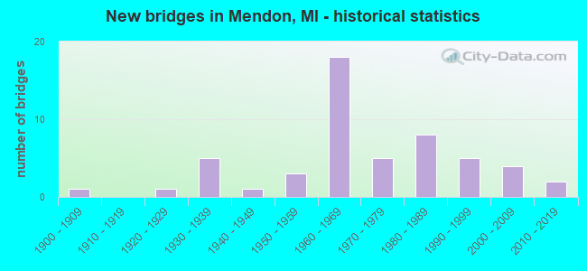
- New bridges - historical statistics
- 11900-1909
- 11920-1929
- 51930-1939
- 11940-1949
- 31950-1959
- 181960-1969
- 51970-1979
- 81980-1989
- 51990-1999
- 42000-2009
- 22010-2019

- Reconstructed bridges - Historical Statistics
- 11960-1969
- 01970-1979
- 01980-1989
- 11990-1999
- 22000-2009
- 22010-2019


- Bridge Condition - Deck
- 6.5%Very good
- 34.8%Good
- 28.3%Satisfactory
- 19.6%Fair
- 10.9%Poor

- Bridge Condition - Superstructure
- 8.7%Very good
- 32.6%Good
- 26.1%Satisfactory
- 26.1%Fair
- 2.2%Poor
- 4.3%Serious

- Bridge Condition - Substructure
- 21.7%Very good
- 32.6%Good
- 28.3%Satisfactory
- 10.9%Fair
- 6.5%Poor

- Bridge Condition - Channel
- 17.1%Very good
- 31.7%Good
- 34.1%Satisfactory
- 14.6%Fair
- 2.4%Poor

- Bridge Condition - Culverts
- 42.9%Good
- 28.6%Satisfactory
- 28.6%Fair
Find on map >> Show street view
Structure Number: 298, Location: APPROX 3/8MI W OF 26TH ST (Lat: 42.739428, Lng: -85.809039), Route carried "on" structure: County highway , Year Built: 1980, Status: Open, Structure Length: 0.64m (2.10ft), Average Daily Traffic: 344 (year 2002), Truck Traffic: 7%, Average Future Daily Traffic: 688 (year 2022), Design Load: H 20, Features Intersected: SMALL CREEK, Facility Carried by Structure: 144TH AVE
Minimum Vertical Clearance: 30.48m (100.00ft), Kilometerpoint: 15.544, Lanes on structure: 2, Owner: County Highway Agency, Approaching Roadway Width: 8.5m (27.9ft), Material/Design: Steel, Design/Construction: Culvert, Number Of Spans In Main Unit: 2, Length of Maximum Span: 2.6m (8.5ft)
Condition: Channel: Fair, Culverts: Satisfactory, Operating Rating: 81.3 metric tons, Method Used To Determine Operating Rating: Load Factor (LF) rating reported by rating factor (RF) method using MS18 loading, Inventory Rating: 48.6 metric tons, Method Used To Determine Inventory Rating: Load Factor (LF) rating reported by rating factor (RF) method using MS18 loading, Structural Evaluation: Equal to present minimum criteria, Waterway Adequacy: Better than present minimum criteria, Approach Roadway Alignment: Equal to present desirable criteria, Designated Inspection Frequency: Every 24 months, Inspection Date: April 2021
Find on map >> Show street view
Structure Number: 299, Location: OVERISEL TWP SEC 25 (Lat: 42.700683, Lng: -85.898917), Route carried "on" structure: County highway , Year Built: 1987, Status: Open, Structure Length: 3.38m (11.09ft), Average Daily Traffic: 300 (year 2002), Truck Traffic: 7%, Average Future Daily Traffic: 600 (year 2022), Design Load: HS 20+Mod, Features Intersected: RABBIT RIVER, Facility Carried by Structure: 36TH STREET
Minimum Vertical Clearance: 30.48m (100.00ft), Kilometerpoint: 15.668, Lanes on structure: 2, Owner: County Highway Agency, Approaching Roadway Width: 9.1m (29.9ft), Material/Design: Prestressed concrete, Design/Construction: Box Beam or Girders - Multiple, Number Of Spans In Main Unit: 2, Length of Maximum Span: 17.0m (55.8ft), Curb-To-Curb Width: 9.4m (30.8ft), Out-to-Out Width: 9.4m (30.8ft)
Condition: Deck: Satisfactory, Superstructure: Satisfactory, Substructure: Satisfactory, Channel: Satisfactory, Operating Rating: 53.1 metric tons, Method Used To Determine Operating Rating: Load Factor (LF) rating reported by rating factor (RF) method using MS18 loading, Inventory Rating: 31.8 metric tons, Method Used To Determine Inventory Rating: Load Factor (LF) rating reported by rating factor (RF) method using MS18 loading, Structural Evaluation: Equal to present minimum criteria, Deck Geometry: Equal to present minimum criteria, Waterway Adequacy: Equal to present desirable criteria, Approach Roadway Alignment: Equal to present desirable criteria, Designated Inspection Frequency: Every 24 months, Inspection Date: May 2021, Deck Structure Type: Concrete Precast Panels, Wearing Surface/Protective System: Wearing Surface: Bituminous, Membrane: Other
Find on map >> Show street view
Structure Number: 507, Location: 7 MI NW OF BARAGA (Lat: 46.836728, Lng: -88.577311), Route carried "on" structure: County highway 723, Year Built: 1985, Status: Open, Structure Length: 1.83m (6.00ft), Average Daily Traffic: 144 (year 2014), Truck Traffic: 2%, Average Future Daily Traffic: 250 (year 2034), Design Load: HS 20, Features Intersected: EASTSTURGEONSLOUGH, Facility Carried by Structure: FROBERG ROAD
Minimum Vertical Clearance: 30+ m (98+ ft), Kilometerpoint: 6.047, Lanes on structure: 2, Owner: County Highway Agency, Approaching Roadway Width: 9.1m (29.9ft), Material/Design: Prestressed concrete, Design/Construction: Box Beam or Girders - Multiple, Number Of Spans In Main Unit: 1, Length of Maximum Span: 16.8m (55.1ft), Curb-To-Curb Width: 9.4m (30.8ft), Out-to-Out Width: 9.5m (31.2ft)
Condition: Deck: Very good, Superstructure: Very good, Substructure: Very good, Channel: Very good, Operating Rating: 87.4 metric tons, Method Used To Determine Operating Rating: Load Factor (LF), Inventory Rating: 53.2 metric tons, Method Used To Determine Inventory Rating: Load Factor (LF), Structural Evaluation: Equal to present desirable criteria, Deck Geometry: Equal to present minimum criteria, Waterway Adequacy: Somewhat better than minimum adequacy, Approach Roadway Alignment: Equal to present desirable criteria, Designated Inspection Frequency: Every 24 months, Inspection Date: September 2021, Deck Structure Type: Concrete Cast-file-Place, Wearing Surface/Protective System: Wearing Surface: Bituminous, Membrane: Preformed Fabric
Find on map >> Show street view
Structure Number: 898, Location: 2.0 MI W OF NILES (Lat: 41.827775, Lng: -86.313447), Route carried "on" structure: County highway , Year Built: 1973, Status: Open, Structure Length: 12.28m (40.29ft), Average Daily Traffic: 7,073 (year 2010), Truck Traffic: 16%, Average Future Daily Traffic: 8,488 (year 2025), Design Load: HS 20, Features Intersected: US-31, Facility Carried by Structure: BUCHANAN ROAD
Minimum Vertical Clearance: 30+ m (98+ ft), Kilometerpoint: 6.167, Lanes on structure: 7, Lanes under structure: 6, Owner: State Highway Agency, Approaching Roadway Width: 19.5m (64.0ft), Material/Design: Steel, Design/Construction: Stringer/Multi-beam, Number Of Spans In Main Unit: 5, Length of Maximum Span: 33.8m (110.9ft), Curb-To-Curb Width: 33.0m (108.3ft), Out-to-Out Width: 35.0m (114.8ft)
Condition: Deck: Satisfactory, Superstructure: Satisfactory, Substructure: Good, Operating Rating: 43.7 metric tons, Method Used To Determine Operating Rating: Load and Resistance Factor Rating (LRFR) rating reported by rating factor(RF) method using HL-93 loadings, Inventory Rating: 32.1 metric tons, Method Used To Determine Inventory Rating: Load and Resistance Factor Rating (LRFR) rating reported by rating factor(RF) method using HL-93 loadings, Structural Evaluation: Equal to present minimum criteria, Deck Geometry: Superior to present desirable criteria, Underclear: Better than present minimum criteria, Approach Roadway Alignment: Equal to present desirable criteria, Designated Inspection Frequency: Every 24 months, Inspection Date: May 2020, Bridge Improvement Cost: $2,036,000, Roadway Improvement Cost: $32,000, Total Project Cost: $376,000, Deck Structure Type: Concrete Cast-file-Place, Wearing Surface/Protective System: Wearing Surface: Monolithic Concrete, Deck Protection: Epoxy Coated Reinforcing
Find on map >> Show street view
Structure Number: 1211, Location: 2.4 MI E OF KALAMAZOO COL (Lat: 42.352108, Lng: -85.253783), Route carried "on" structure: State highway 89, Year Built: 1947, Status: Open, Structure Length: 1.37m (4.49ft), Average Daily Traffic: 14,726 (year 2007), Truck Traffic: 2%, Average Future Daily Traffic: 14,359 (year 2018), Design Load: HS 20, Features Intersected: WABASCON CREEK
Minimum Vertical Clearance: 30.48m (100.00ft), Kilometerpoint: 4.094, Lanes on structure: 4, Owner: State Highway Agency, Approaching Roadway Width: 14.2m (46.6ft), Material/Design: Steel, Design/Construction: Stringer/Multi-beam, Number Of Spans In Main Unit: 1, Length of Maximum Span: 13.7m (44.9ft), Curb or Sidewalk Widths: Left: 2.1m (6.9ft), Right: 1.3m (4.3ft), Curb-To-Curb Width: 14.2m (46.6ft), Out-to-Out Width: 18.4m (60.4ft)
Condition: Deck: Poor, Superstructure: Fair, Substructure: Satisfactory, Channel: Poor, Operating Rating: 54.1 metric tons, Method Used To Determine Operating Rating: Load Factor (LF) rating reported by rating factor (RF) method using MS18 loading, Inventory Rating: 25.9 metric tons, Method Used To Determine Inventory Rating: Load Factor (LF) rating reported by rating factor (RF) method using MS18 loading, Structural Evaluation: Somewhat better than minimum adequacy, Deck Geometry: High priority of replacement, Waterway Adequacy: Equal to present desirable criteria, Approach Roadway Alignment: Equal to present desirable criteria, Length Of Structure Improvement: 1.37m (4.49ft), Designated Inspection Frequency: Every 24 months, Other Special Inspection Frequency: Every 24 months, Inspection Date: August 2021, Other Special Inspection Date: August 2020, Bridge Improvement Cost: $38,000, Roadway Improvement Cost: $4,000, Total Project Cost: $42,000, Deck Structure Type: Concrete Cast-file-Place, Wearing Surface/Protective System: Wearing Surface: Latex Concrete
Find on map >> Show street view
Structure Number: 1212, Location: 0.2 MI E M-96 (COLUMBIA) (Lat: 42.310869, Lng: -85.137078), Route carried "on" structure: Business Interstate 94, Year Built: 1998, Status: Open, Structure Length: 3.65m (11.98ft), Average Daily Traffic: 13,099 (year 2007), Truck Traffic: 2%, Average Future Daily Traffic: 5,800 (year 2029), Design Load: HS 25 or greater, Features Intersected: MDOT RR CORRIDOR
Minimum Vertical Clearance: 30.48m (100.00ft), Kilometerpoint: 3.734, Lanes on structure: 4, Base Highway Network: Yes (Inventory Route: 313, Subroute: 75), Owner: State Highway Agency, Approaching Roadway Width: 12.8m (42.0ft), Skew: 2 degrees, Material/Design: Prestressed concrete, Design/Construction: Stringer/Multi-beam, Number Of Spans In Main Unit: 3, Length of Maximum Span: 18.6m (61.0ft), Curb-To-Curb Width: 25.3m (83.0ft), Out-to-Out Width: 26.2m (86.0ft)
Condition: Deck: Satisfactory, Superstructure: Good, Substructure: Good, Operating Rating: 48.0 metric tons, Method Used To Determine Operating Rating: Load and Resistance Factor Rating (LRFR) rating reported by rating factor(RF) method using HL-93 loadings, Inventory Rating: 31.8 metric tons, Method Used To Determine Inventory Rating: Load and Resistance Factor Rating (LRFR) rating reported by rating factor(RF) method using HL-93 loadings, Structural Evaluation: Better than present minimum criteria, Deck Geometry: Superior to present desirable criteria, Underclear: Meets minimum limits, Approach Roadway Alignment: Equal to present desirable criteria, Designated Inspection Frequency: Every 24 months, Inspection Date: August 2021, Deck Structure Type: Concrete Cast-file-Place, Wearing Surface/Protective System: Wearing Surface: Epoxy Overlay, Deck Protection: Epoxy Coated Reinforcing
Find on map >> Show street view
Structure Number: 1213, Location: 1.2 MI N OF BRANCH COL (Lat: 42.087958, Lng: -84.998189), Route carried "on" structure: Interstate 69, Year Built: 1968, Status: Open, Structure Length: 4.05m (13.29ft), Average Daily Traffic: 11,162 (year 2007), Truck Traffic: 33%, Average Future Daily Traffic: 11,991 (year 2018), Design Load: HS 20+Mod, Features Intersected: ST JOSEPH RIVER
Minimum Vertical Clearance: 30.48m (100.00ft), Kilometerpoint: 2.190, Lanes on structure: 2, Base Highway Network: Yes (Inventory Route: 129, Subroute: 1), Owner: State Highway Agency, Approaching Roadway Width: 11.6m (38.1ft), Material/Design: Prestressed concrete, Design/Construction: Stringer/Multi-beam, Number Of Spans In Main Unit: 3, Length of Maximum Span: 15.2m (49.9ft), Curb-To-Curb Width: 11.6m (38.1ft), Out-to-Out Width: 12.9m (42.3ft)
Condition: Deck: Fair, Superstructure: Fair, Substructure: Satisfactory, Channel: Fair, Operating Rating: 74.8 metric tons, Method Used To Determine Operating Rating: Load Factor (LF) rating reported by rating factor (RF) method using MS18 loading, Inventory Rating: 44.7 metric tons, Method Used To Determine Inventory Rating: Load Factor (LF) rating reported by rating factor (RF) method using MS18 loading, Structural Evaluation: Somewhat better than minimum adequacy, Deck Geometry: Equal to present minimum criteria, Waterway Adequacy: Equal to present desirable criteria, Approach Roadway Alignment: Equal to present desirable criteria, Designated Inspection Frequency: Every 24 months, Inspection Date: June 2021, Deck Structure Type: Concrete Cast-file-Place, Wearing Surface/Protective System: Wearing Surface: Monolithic Concrete
Find on map >> Show street view
Structure Number: 1842, Location: 0.5 NW OF ST JOHNS (Lat: 43.023950, Lng: -84.543039), Route carried "on" structure: County highway , Year Built: 1994, Status: Open, Structure Length: 8.65m (28.38ft), Average Daily Traffic: 1,000 (year 1994), Truck Traffic: 3%, Average Future Daily Traffic: 1,000 (year 2010), Design Load: HS 20, Features Intersected: US-127, Facility Carried by Structure: SCOTT ROAD
Minimum Vertical Clearance: 30.48m (100.00ft), Kilometerpoint: 3.933, Lanes on structure: 2, Lanes under structure: 4, Owner: State Highway Agency, Approaching Roadway Width: 12.2m (40.0ft), Material/Design: Prestressed concrete, Design/Construction: Stringer/Multi-beam, Number Of Spans In Main Unit: 4, Length of Maximum Span: 32.6m (107.0ft), Curb-To-Curb Width: 12.2m (40.0ft), Out-to-Out Width: 13.2m (43.3ft)
Condition: Deck: Good, Superstructure: Satisfactory, Substructure: Good, Operating Rating: 53.5 metric tons, Method Used To Determine Operating Rating: Load Factor (LF) rating reported by rating factor (RF) method using MS18 loading, Inventory Rating: 36.9 metric tons, Method Used To Determine Inventory Rating: Load Factor (LF) rating reported by rating factor (RF) method using MS18 loading, Structural Evaluation: Equal to present minimum criteria, Deck Geometry: Equal to present desirable criteria, Underclear: Superior to present desirable criteria, Approach Roadway Alignment: Equal to present desirable criteria, Designated Inspection Frequency: Every 24 months, Inspection Date: June 2020, Deck Structure Type: Concrete Cast-file-Place, Wearing Surface/Protective System: Wearing Surface: Monolithic Concrete, Deck Protection: Epoxy Coated Reinforcing
Find on map >> Show street view
Structure Number: 1844, Location: 0.4 MILES EAST OF US-127 (Lat: 42.803319, Lng: -84.502333), Route carried "on" structure: Interstate 69, Year Built: 1985, Status: Open, Structure Length: 0.93m (3.05ft), Average Daily Traffic: 34,700 (year 2013), Truck Traffic: 14%, Average Future Daily Traffic: 40,300 (year 2033), Design Load: HS 20+Mod, Features Intersected: REMY-CHANDLER DRAIN
Minimum Vertical Clearance: 30.48m (100.00ft), Kilometerpoint: 16.286, Lanes on structure: 8, Base Highway Network: Yes (Inventory Route: 36, Subroute: 5), Owner: State Highway Agency, Approaching Roadway Width: 27.4m (89.9ft), Material/Design: Concrete, Design/Construction: Culvert, Number Of Spans In Main Unit: 1, Length of Maximum Span: 9.1m (29.9ft), Out-to-Out Width: 117.0m (383.9ft)
Condition: Channel: Very good, Culverts: Good, Operating Rating: 68.3 metric tons, Method Used To Determine Operating Rating: Field evaluation and documented engineering judgment, Inventory Rating: 40.8 metric tons, Method Used To Determine Inventory Rating: Field evaluation and documented engineering judgment, Structural Evaluation: Better than present minimum criteria, Waterway Adequacy: Equal to present desirable criteria, Approach Roadway Alignment: Equal to present desirable criteria, Designated Inspection Frequency: Every 24 months, Inspection Date: May 2020
Find on map >> Show street view
Structure Number: 2235, Location: 9.6 MI NW OF CHARLOTTE (Lat: 42.671200, Lng: -84.928364), Route carried "on" structure: State highway 50, Year Built: 2013, Status: Open, Structure Length: 0.79m (2.59ft), Average Daily Traffic: 2,842 (year 2012), Truck Traffic: 17%, Average Future Daily Traffic: 3,350 (year 2032), Design Load: Greater than HL93, Features Intersected: CREEK
Minimum Vertical Clearance: 30.48m (100.00ft), Kilometerpoint: 15.902, Lanes on structure: 2, Base Highway Network: Yes (Inventory Route: 56, Subroute: 4), Owner: State Highway Agency, Approaching Roadway Width: 12.2m (40.0ft), Material/Design: Concrete, Design/Construction: Culvert, Number Of Spans In Main Unit: 1, Length of Maximum Span: 7.3m (24.0ft), Curb-To-Curb Width: 12.2m (40.0ft), Out-to-Out Width: 13.7m (44.9ft)
Condition: Channel: Good, Culverts: Good, Operating Rating: 86.8 metric tons, Method Used To Determine Operating Rating: Load and Resistance Factor Rating (LRFR) rating reported by rating factor(RF) method using HL-93 loadings, Inventory Rating: 67.1 metric tons, Method Used To Determine Inventory Rating: Load and Resistance Factor Rating (LRFR) rating reported by rating factor(RF) method using HL-93 loadings, Structural Evaluation: Better than present minimum criteria, Deck Geometry: Equal to present minimum criteria, Waterway Adequacy: Equal to present desirable criteria, Approach Roadway Alignment: Equal to present desirable criteria, Designated Inspection Frequency: Every 24 months, Inspection Date: June 2021, Wearing Surface/Protective System: Wearing Surface: Bituminous
Find on map >> Show street view
Structure Number: 2953, Location: 1.4 MI SE OF WAKEFIELD (Lat: 46.451122, Lng: -89.866339), Route carried "on" structure: US 2, Year Built: 1936, Status: Open, Structure Length: 1.09m (3.58ft), Average Daily Traffic: 1,177 (year 2007), Truck Traffic: 12%, Average Future Daily Traffic: 2,448 (year 2018), Design Load: H 15, Features Intersected: JACKSON CREEK BURIED
Minimum Vertical Clearance: 30.48m (100.00ft), Kilometerpoint: 26.764, Lanes on structure: 2, Base Highway Network: Yes (Inventory Route: 147, Subroute: 1), Owner: State Highway Agency, Approaching Roadway Width: 12.2m (40.0ft), Material/Design: Concrete, Design/Construction: Culvert, Number Of Spans In Main Unit: 3, Length of Maximum Span: 3.6m (11.8ft), Curb-To-Curb Width: 11.0m (36.1ft), Out-to-Out Width: 42.6m (139.8ft)
Condition: Channel: Satisfactory, Culverts: Satisfactory, Operating Rating: 40.5 metric tons, Method Used To Determine Operating Rating: Field evaluation and documented engineering judgment, Inventory Rating: 24.3 metric tons, Method Used To Determine Inventory Rating: Field evaluation and documented engineering judgment, Structural Evaluation: Equal to present minimum criteria, Deck Geometry: Equal to present minimum criteria, Waterway Adequacy: Equal to present desirable criteria, Approach Roadway Alignment: Equal to present desirable criteria, Designated Inspection Frequency: Every 24 months, Inspection Date: August 2021, Bridge Improvement Cost: $72,000, Deck Structure Type: Concrete Cast-file-Place, Wearing Surface/Protective System: Wearing Surface: Bituminous, Membrane: Preformed Fabric
Find on map >> Show street view
Structure Number: 2955, Location: 0.3 MI E OF M-64 (Lat: 46.388133, Lng: -89.690208), Route carried "on" structure: US 2, Year Built: 1937, Year Reconstructed: 2000, Status: Open, Structure Length: 3.05m (10.01ft), Average Daily Traffic: 1,100 (year 2019), Truck Traffic: 10%, Average Future Daily Traffic: 1,200 (year 2039), Design Load: H 15, Features Intersected: BIG PRESQUE ISLE RIVER
Minimum Vertical Clearance: 30.48m (100.00ft), Kilometerpoint: 42.541, Lanes on structure: 2, Base Highway Network: Yes (Inventory Route: 147, Subroute: 1), Owner: State Highway Agency, Approaching Roadway Width: 11.0m (36.1ft), Skew: 3 degrees, Material/Design: Steel, Design/Construction: Stringer/Multi-beam, Number Of Spans In Main Unit: 2, Length of Maximum Span: 15.2m (49.9ft), Curb-To-Curb Width: 12.2m (40.0ft), Out-to-Out Width: 13.2m (43.3ft)
Condition: Deck: Good, Superstructure: Good, Substructure: Good, Channel: Good, Operating Rating: 79.1 metric tons, Method Used To Determine Operating Rating: Load Factor (LF) rating reported by rating factor (RF) method using MS18 loading, Inventory Rating: 47.3 metric tons, Method Used To Determine Inventory Rating: Load Factor (LF) rating reported by rating factor (RF) method using MS18 loading, Structural Evaluation: Better than present minimum criteria, Deck Geometry: Better than present minimum criteria, Waterway Adequacy: Equal to present minimum criteria, Approach Roadway Alignment: Better than present minimum criteria, Length Of Structure Improvement: 3.05m (10.01ft), Designated Inspection Frequency: Every 24 months, Inspection Date: August 2021, Bridge Improvement Cost: $76,000, Roadway Improvement Cost: $1,000, Total Project Cost: $16,000, Deck Structure Type: Concrete Cast-file-Place, Wearing Surface/Protective System: Wearing Surface: Epoxy Overlay
Find on map >> Show street view
Structure Number: 2978, Location: SEC 32-33 IRONWOOD TWP (Lat: 46.515647, Lng: -90.197661), Route carried "on" structure: County highway , Year Built: 1988, Status: Open, Structure Length: 2.13m (6.99ft), Average Daily Traffic: 250 (year 1998), Average Future Daily Traffic: 250 (year 2018), Design Load: HS 20+Mod, Features Intersected: SPRING CREEK, Facility Carried by Structure: JUNET ROAD
Minimum Vertical Clearance: 30.48m (100.00ft), Kilometerpoint: 4.592, Lanes on structure: 2, Owner: County Highway Agency, Approaching Roadway Width: 7.9m (25.9ft), Material/Design: Prestressed concrete, Design/Construction: Box Beam or Girders - Multiple, Number Of Spans In Main Unit: 1, Length of Maximum Span: 20.7m (67.9ft), Curb-To-Curb Width: 8.2m (26.9ft), Out-to-Out Width: 8.5m (27.9ft)
Condition: Deck: Fair, Superstructure: Good, Substructure: Very good, Channel: Good, Operating Rating: 68.7 metric tons, Method Used To Determine Operating Rating: Load Factor (LF) rating reported by rating factor (RF) method using MS18 loading, Inventory Rating: 40.8 metric tons, Method Used To Determine Inventory Rating: Load Factor (LF) rating reported by rating factor (RF) method using MS18 loading, Structural Evaluation: Better than present minimum criteria, Deck Geometry: Somewhat better than minimum adequacy, Waterway Adequacy: Equal to present desirable criteria, Approach Roadway Alignment: Better than present minimum criteria, Length Of Structure Improvement: 2.56m (8.40ft), Designated Inspection Frequency: Every 24 months, Inspection Date: September 2020, Bridge Improvement Cost: $359,000, Roadway Improvement Cost: $36,000, Total Project Cost: $494,000, Deck Structure Type: Concrete Precast Panels, Wearing Surface/Protective System: Wearing Surface: Bituminous, Membrane: Preformed Fabric, Deck Protection: Epoxy Coated Reinforcing
Find on map >> Show street view
Structure Number: 2979, Location: SEC 14 ERWIN TWP (Lat: 46.387419, Lng: -90.141356), Route carried "on" structure: County highway 2719, Year Built: 1975, Status: Open, Structure Length: 1.70m (5.58ft), Average Daily Traffic: 183 (year 1998), Truck Traffic: 35%, Average Future Daily Traffic: 183 (year 2018), Design Load: H 20, Features Intersected: MONTREAL RIVER, Facility Carried by Structure: VAN BUSKIRK ROAD
Minimum Vertical Clearance: 30.48m (100.00ft), Kilometerpoint: 0.423, Lanes on structure: 2, Owner: County Highway Agency, Approaching Roadway Width: 9.1m (29.9ft), Skew: 2 degrees, Material/Design: Prestressed concrete, Design/Construction: Box Beam or Girders - Multiple, Number Of Spans In Main Unit: 1, Length of Maximum Span: 16.4m (53.8ft), Curb-To-Curb Width: 9.1m (29.9ft), Out-to-Out Width: 9.2m (30.2ft)
Condition: Deck: Fair, Superstructure: Good, Substructure: Satisfactory, Channel: Good, Operating Rating: 63.0 metric tons, Method Used To Determine Operating Rating: Allowable Stress (AS), Inventory Rating: 38.0 metric tons, Method Used To Determine Inventory Rating: Allowable Stress (AS), Structural Evaluation: Equal to present minimum criteria, Deck Geometry: Equal to present minimum criteria, Waterway Adequacy: Equal to present desirable criteria, Approach Roadway Alignment: Better than present minimum criteria, Length Of Structure Improvement: 2.05m (6.73ft), Designated Inspection Frequency: Every 24 months, Inspection Date: September 2020, Bridge Improvement Cost: $287,000, Roadway Improvement Cost: $29,000, Total Project Cost: $395,000, Deck Structure Type: Concrete Precast Panels, Wearing Surface/Protective System: Wearing Surface: Bituminous, Membrane: Preformed Fabric
Find on map >> Show street view
Structure Number: 2982, Location: SEC 32 IRONWOOD TWP (Lat: 46.607822, Lng: -90.330239), Route carried "on" structure: County highway 2778, Year Built: 2008, Status: Open, Structure Length: 1.89m (6.20ft), Average Daily Traffic: 350 (year 2007), Average Future Daily Traffic: 375 (year 2027), Design Load: HS 20, Features Intersected: OMANS CREEK, Facility Carried by Structure: LAKE ROAD
Minimum Vertical Clearance: 30.48m (100.00ft), Kilometerpoint: 9.149, Lanes on structure: 2, Owner: County Highway Agency, Approaching Roadway Width: 8.5m (27.9ft), Skew: 2 degrees, Material/Design: Prestressed concrete, Design/Construction: Box Beam or Girders - Multiple, Number Of Spans In Main Unit: 1, Length of Maximum Span: 18.5m (60.7ft), Curb-To-Curb Width: 8.9m (29.2ft), Out-to-Out Width: 9.5m (31.2ft)
Condition: Deck: Good, Superstructure: Very good, Substructure: Good, Channel: Good, Operating Rating: 62.4 metric tons, Method Used To Determine Operating Rating: Load Factor (LF), Inventory Rating: 37.4 metric tons, Method Used To Determine Inventory Rating: Load Factor (LF), Structural Evaluation: Better than present minimum criteria, Deck Geometry: Equal to present minimum criteria, Waterway Adequacy: Equal to present desirable criteria, Approach Roadway Alignment: Equal to present desirable criteria, Designated Inspection Frequency: Every 24 months, Inspection Date: September 2020, Deck Structure Type: Concrete Cast-file-Place, Wearing Surface/Protective System: Wearing Surface: Monolithic Concrete, Deck Protection: Epoxy Coated Reinforcing
Find on map >> Show street view
Structure Number: 2984, Location: SEC 4-9 ERWIN TWP (Lat: 46.405503, Lng: -90.060753), Route carried "on" structure: County highway , Year Built: 1992, Status: Open, Structure Length: 2.13m (6.99ft), Average Daily Traffic: 80 (year 1998), Average Future Daily Traffic: 100 (year 2018), Design Load: HS 20+Mod, Features Intersected: BLACK RIVER, Facility Carried by Structure: S BLACK RIVER RD
Minimum Vertical Clearance: 30.48m (100.00ft), Kilometerpoint: 3.925, Lanes on structure: 2, Owner: County Highway Agency, Approaching Roadway Width: 9.1m (29.9ft), Material/Design: Prestressed concrete, Design/Construction: Box Beam or Girders - Multiple, Number Of Spans In Main Unit: 1, Length of Maximum Span: 20.7m (67.9ft), Curb-To-Curb Width: 9.1m (29.9ft), Out-to-Out Width: 9.4m (30.8ft)
Condition: Deck: Satisfactory, Superstructure: Good, Substructure: Very good, Channel: Satisfactory, Operating Rating: 72.7 metric tons, Method Used To Determine Operating Rating: Allowable Stress (AS), Inventory Rating: 49.2 metric tons, Method Used To Determine Inventory Rating: Allowable Stress (AS), Structural Evaluation: Better than present minimum criteria, Deck Geometry: Better than present minimum criteria, Waterway Adequacy: Superior to present desirable criteria, Approach Roadway Alignment: Equal to present desirable criteria, Length Of Structure Improvement: 2.56m (8.40ft), Designated Inspection Frequency: Every 24 months, Inspection Date: September 2020, Bridge Improvement Cost: $359,000, Roadway Improvement Cost: $36,000, Total Project Cost: $494,000, Deck Structure Type: Concrete Precast Panels, Wearing Surface/Protective System: Wearing Surface: Bituminous, Membrane: Preformed Fabric, Deck Protection: Epoxy Coated Reinforcing
Find on map >> Show street view
Structure Number: 2985, Location: SEC 3-4 ERWIN TWP (Lat: 46.410342, Lng: -90.052572), Route carried "on" structure: County highway , Year Built: 2000, Status: Open, Structure Length: 2.50m (8.20ft), Average Daily Traffic: 250 (year 1998), Average Future Daily Traffic: 275 (year 2016), Design Load: HS 20+Mod, Features Intersected: BLACK RIVER, Facility Carried by Structure: JOHNSON ROAD
Minimum Vertical Clearance: 30.48m (100.00ft), Kilometerpoint: 1.347, Lanes on structure: 2, Owner: County Highway Agency, Approaching Roadway Width: 9.1m (29.9ft), Skew: 4 degrees, Material/Design: Prestressed concrete, Design/Construction: Box Beam or Girders - Multiple, Number Of Spans In Main Unit: 1, Length of Maximum Span: 23.7m (77.8ft), Curb-To-Curb Width: 9.4m (30.8ft), Out-to-Out Width: 9.5m (31.2ft)
Condition: Deck: Fair, Superstructure: Satisfactory, Substructure: Very good, Channel: Good, Operating Rating: 63.5 metric tons, Method Used To Determine Operating Rating: Load Factor (LF), Inventory Rating: 38.1 metric tons, Method Used To Determine Inventory Rating: Load Factor (LF), Structural Evaluation: Equal to present minimum criteria, Waterway Adequacy: Equal to present desirable criteria, Approach Roadway Alignment: Equal to present desirable criteria, Designated Inspection Frequency: Every 24 months, Inspection Date: September 2020, Deck Structure Type: Concrete Precast Panels, Wearing Surface/Protective System: Wearing Surface: Bituminous, Membrane: Preformed Fabric, Deck Protection: Epoxy Coated Reinforcing
Find on map >> Show street view
Structure Number: 2987, Location: SEC 21 WAKEFIELD TWP (Lat: 46.457975, Lng: -89.943269), Route carried "on" structure: County highway 2739, Year Built: 1934, Status: Open, Structure Length: 1.22m (4.00ft), Average Daily Traffic: 329 (year 1998), Average Future Daily Traffic: 329 (year 2018), Design Load: H 15, Features Intersected: LITTLE BLACK RIVER, Facility Carried by Structure: CHANEY LAKE ROAD
Minimum Vertical Clearance: 30.48m (100.00ft), Kilometerpoint: 19.825, Lanes on structure: 2, Owner: County Highway Agency, Approaching Roadway Width: 10.4m (34.1ft), Skew: 3 degrees, Material/Design: Steel, Design/Construction: Stringer/Multi-beam, Number Of Spans In Main Unit: 1, Length of Maximum Span: 11.5m (37.7ft), Curb-To-Curb Width: 8.5m (27.9ft), Out-to-Out Width: 10.2m (33.5ft)
Condition: Deck: Poor, Superstructure: Fair, Substructure: Satisfactory, Channel: Satisfactory, Operating Rating: 54.8 metric tons, Method Used To Determine Operating Rating: Load Factor (LF) rating reported by rating factor (RF) method using MS18 loading, Inventory Rating: 32.7 metric tons, Method Used To Determine Inventory Rating: Load Factor (LF) rating reported by rating factor (RF) method using MS18 loading, Structural Evaluation: Somewhat better than minimum adequacy, Deck Geometry: Equal to present minimum criteria, Waterway Adequacy: Equal to present minimum criteria, Approach Roadway Alignment: Equal to present desirable criteria, Length Of Structure Improvement: 1.46m (4.79ft), Designated Inspection Frequency: Every 24 months, Inspection Date: September 2020, Bridge Improvement Cost: $205,000, Roadway Improvement Cost: $21,000, Total Project Cost: $283,000, Deck Structure Type: Concrete Cast-file-Place, Wearing Surface/Protective System: Wearing Surface: Bituminous
Find on map >> Show street view
Structure Number: 2988, Location: SEC 4 WAKEFIELD TWP (Lat: 46.504689, Lng: -89.936275), Route carried "on" structure: County highway 2741, Year Built: 1986, Status: Open, Structure Length: 0.73m (2.40ft), Average Daily Traffic: 544 (year 1998), Average Future Daily Traffic: 544 (year 2018), Design Load: HS 20, Features Intersected: PLANTERS CREEK, Facility Carried by Structure: PRESQUE ISLE ROAD
Minimum Vertical Clearance: 30.48m (100.00ft), Kilometerpoint: 2.147, Lanes on structure: 2, Owner: County Highway Agency, Approaching Roadway Width: 9.1m (29.9ft), Material/Design: Concrete, Design/Construction: Culvert, Number Of Spans In Main Unit: 2, Length of Maximum Span: 2.7m (8.9ft)
Condition: Channel: Satisfactory, Culverts: Good, Operating Rating: 59.1 metric tons, Method Used To Determine Operating Rating: Allowable Stress (AS), Inventory Rating: 32.7 metric tons, Method Used To Determine Inventory Rating: Allowable Stress (AS), Structural Evaluation: Better than present minimum criteria, Waterway Adequacy: Equal to present desirable criteria, Approach Roadway Alignment: Equal to present desirable criteria, Length Of Structure Improvement: 0.88m (2.89ft), Designated Inspection Frequency: Every 24 months, Inspection Date: September 2020, Bridge Improvement Cost: $123,000, Roadway Improvement Cost: $13,000, Total Project Cost: $169,000
Find on map >> Show street view
Structure Number: 4038, Location: 2.25 MI W OF CLARKSVILLE (Lat: 42.842700, Lng: -85.291886), Route carried "on" structure: ServiceCounty highway , Year Built: 2008, Status: Open, Structure Length: 1.22m (4.00ft), Average Daily Traffic: 1,183 (year 2007), Truck Traffic: 12%, Average Future Daily Traffic: 1,376 (year 2027), Features Intersected: TYLER CREEK, Facility Carried by Structure: HASTINGS ROAD
Minimum Vertical Clearance: 30.48m (100.00ft), Kilometerpoint: 8.092, Lanes on structure: 2, Owner: County Highway Agency, Approaching Roadway Width: 9.4m (30.8ft), Skew: 4 degrees, Material/Design: Prestressed concrete, Design/Construction: Box Beam or Girders - Multiple, Number Of Spans In Main Unit: 1, Length of Maximum Span: 11.4m (37.4ft), Curb-To-Curb Width: 9.4m (30.8ft), Out-to-Out Width: 10.5m (34.4ft)
Condition: Deck: Very good, Superstructure: Good, Substructure: Good, Channel: Very good, Operating Rating: 97.2 metric tons, Method Used To Determine Operating Rating: Load Factor (LF) rating reported by rating factor (RF) method using MS18 loading, Inventory Rating: 63.5 metric tons, Method Used To Determine Inventory Rating: Load Factor (LF) rating reported by rating factor (RF) method using MS18 loading, Structural Evaluation: Better than present minimum criteria, Deck Geometry: Somewhat better than minimum adequacy, Waterway Adequacy: Equal to present desirable criteria, Approach Roadway Alignment: Equal to present desirable criteria, Designated Inspection Frequency: Every 24 months, Inspection Date: October 2021, Deck Structure Type: Concrete Cast-file-Place, Wearing Surface/Protective System: Wearing Surface: Monolithic Concrete, Deck Protection: Epoxy Coated Reinforcing
Find on map >> Show street view
Structure Number: 4043, Location: 2 MI W OF MUIR & 2.3 MI N (Lat: 43.036164, Lng: -84.995822), Route carried "on" structure: ServiceCounty highway 3457, Year Built: 1959, Status: Posted for load, Structure Length: 1.34m (4.40ft), Average Daily Traffic: 1,036 (year 2007), Truck Traffic: 7%, Average Future Daily Traffic: 1,205 (year 2027), Design Load: HS 20+Mod, Features Intersected: PRAIRIE CREEK, Facility Carried by Structure: STAGE RD
Minimum Vertical Clearance: 30.48m (100.00ft), Kilometerpoint: 4.880, Lanes on structure: 2, Owner: County Highway Agency, Approaching Roadway Width: 9.1m (29.9ft), Material/Design: Prestressed concrete, Design/Construction: Box Beam or Girders - Multiple, Number Of Spans In Main Unit: 1, Length of Maximum Span: 12.2m (40.0ft), Curb-To-Curb Width: 9.1m (29.9ft), Out-to-Out Width: 9.3m (30.5ft)
Condition: Deck: Fair, Superstructure: Fair, Substructure: Satisfactory, Channel: Satisfactory, Operating Rating: 44.1 metric tons, Method Used To Determine Operating Rating: Load Factor (LF) rating reported by rating factor (RF) method using MS18 loading, Inventory Rating: 26.2 metric tons, Method Used To Determine Inventory Rating: Load Factor (LF) rating reported by rating factor (RF) method using MS18 loading, Structural Evaluation: Somewhat better than minimum adequacy, Deck Geometry: Somewhat better than minimum adequacy, Waterway Adequacy: Equal to present minimum criteria, Approach Roadway Alignment: Equal to present minimum criteria, Bridge Posting: Required (Relationship of Operating Rating to Maximum Legal Load: 10.0 - 19.9% below), Designated Inspection Frequency: Every 24 months, Inspection Date: October 2021, Deck Structure Type: Concrete Precast Panels, Wearing Surface/Protective System: Wearing Surface: Bituminous
Find on map >> Show street view
Structure Number: 4253, Location: 0.7 MI N OF M-20 (Lat: 43.618286, Lng: -84.748106), Route carried "on" structure: County highway 2024, Year Built: 1964, Status: Open, Structure Length: 7.01m (23.00ft), Average Daily Traffic: 110 (year 1974), Truck Traffic: 3%, Average Future Daily Traffic: 110 (year 1977), Design Load: H 15, Features Intersected: US-127, Facility Carried by Structure: ISABELLA RD
Minimum Vertical Clearance: 30.48m (100.00ft), Kilometerpoint: 6.037, Lanes on structure: 2, Lanes under structure: 4, Owner: State Highway Agency, Approaching Roadway Width: 10.9m (35.8ft), Skew: 2 degrees, Material/Design: Steel, Design/Construction: Stringer/Multi-beam, Number Of Spans In Main Unit: 4, Length of Maximum Span: 24.3m (79.7ft), Curb or Sidewalk Widths: Left: 0.7m (2.3ft), Right: 0.7m (2.3ft), Curb-To-Curb Width: 7.9m (25.9ft), Out-to-Out Width: 10.1m (33.1ft)
Condition: Deck: Satisfactory, Superstructure: Fair, Substructure: Satisfactory, Operating Rating: 52.5 metric tons, Method Used To Determine Operating Rating: Load Factor (LF) rating reported by rating factor (RF) method using MS18 loading, Inventory Rating: 27.5 metric tons, Method Used To Determine Inventory Rating: Load Factor (LF) rating reported by rating factor (RF) method using MS18 loading, Structural Evaluation: Somewhat better than minimum adequacy, Deck Geometry: Somewhat better than minimum adequacy, Underclear: High priority of corrective action, Approach Roadway Alignment: Equal to present desirable criteria, Designated Inspection Frequency: Every 24 months, Other Special Inspection Frequency: Every 12 months, Inspection Date: April 2021, Other Special Inspection Date: April 2021, Deck Structure Type: Concrete Cast-file-Place, Wearing Surface/Protective System: Wearing Surface: Monolithic Concrete
Find on map >> Show street view
Structure Number: 4254, Location: @ US-127 BR (Lat: 43.623183, Lng: -84.758483), Route carried "on" structure: Business US 127, Year Built: 1961, Status: Open, Structure Length: 7.19m (23.59ft), Average Daily Traffic: 2,953 (year 2007), Truck Traffic: 4%, Average Future Daily Traffic: 5,305 (year 2018), Design Load: HS 20, Features Intersected: US-127 SB
Minimum Vertical Clearance: 30.48m (100.00ft), Kilometerpoint: 8.984, Lanes on structure: 2, Lanes under structure: 2, Base Highway Network: Yes (Inventory Route: 24, Subroute: 4), Owner: State Highway Agency, Approaching Roadway Width: 10.9m (35.8ft), Skew: 5 degrees, Material/Design: Steel, Design/Construction: Stringer/Multi-beam, Number Of Spans In Main Unit: 3, Length of Maximum Span: 32.4m (106.3ft), Curb-To-Curb Width: 10.0m (32.8ft), Out-to-Out Width: 11.2m (36.7ft)
Condition: Deck: Poor, Superstructure: Fair, Substructure: Fair, Operating Rating: 69.0 metric tons, Method Used To Determine Operating Rating: Load Factor (LF) rating reported by rating factor (RF) method using MS18 loading, Inventory Rating: 41.5 metric tons, Method Used To Determine Inventory Rating: Load Factor (LF) rating reported by rating factor (RF) method using MS18 loading, Structural Evaluation: Somewhat better than minimum adequacy, Deck Geometry: Meets minimum limits, Underclear: Meets minimum limits, Approach Roadway Alignment: Equal to present desirable criteria, Designated Inspection Frequency: Every 12 months, Inspection Date: April 2021, Bridge Improvement Cost: $32,000, Deck Structure Type: Concrete Cast-file-Place, Wearing Surface/Protective System: Wearing Surface: Monolithic Concrete
Find on map >> Show street view
Structure Number: 4255, Location: 1.1 MI N OF US-127 BR (Lat: 43.640569, Lng: -84.758519), Route carried "on" structure: County highway 3748, Year Built: 1965, Year Reconstructed: 2015, Status: Open, Structure Length: 6.39m (20.96ft), Average Daily Traffic: 230 (year 1974), Average Future Daily Traffic: 230 (year 1977), Design Load: H 15, Features Intersected: US-127, Facility Carried by Structure: BASELINE RD
Minimum Vertical Clearance: 30.48m (100.00ft), Kilometerpoint: 16.511, Lanes on structure: 2, Lanes under structure: 4, Owner: State Highway Agency, Approaching Roadway Width: 9.1m (29.9ft), Material/Design: Prestressed concrete, Design/Construction: Stringer/Multi-beam, Number Of Spans In Main Unit: 4, Length of Maximum Span: 21.9m (71.9ft), Curb-To-Curb Width: 7.9m (25.9ft), Out-to-Out Width: 9.6m (31.5ft)
Condition: Deck: Good, Superstructure: Satisfactory, Substructure: Good, Operating Rating: 55.7 metric tons, Method Used To Determine Operating Rating: Load Factor (LF) rating reported by rating factor (RF) method using MS18 loading, Inventory Rating: 29.2 metric tons, Method Used To Determine Inventory Rating: Load Factor (LF) rating reported by rating factor (RF) method using MS18 loading, Structural Evaluation: Equal to present minimum criteria, Deck Geometry: Somewhat better than minimum adequacy, Underclear: Somewhat better than minimum adequacy, Approach Roadway Alignment: Equal to present desirable criteria, Designated Inspection Frequency: Every 24 months, Inspection Date: April 2021, Deck Structure Type: Concrete Cast-file-Place, Wearing Surface/Protective System: Wearing Surface: Latex Concrete
Find on map >> Show street view
Structure Number: 4256, Location: 3.1 MI N OF US-127BR (Lat: 43.669153, Lng: -84.758386), Route carried "on" structure: County highway , Year Built: 1964, Year Reconstructed: 2015, Status: Open, Structure Length: 6.64m (21.78ft), Average Daily Traffic: 230 (year 1974), Average Future Daily Traffic: 230 (year 1977), Design Load: H 15, Features Intersected: US-127, Facility Carried by Structure: BEAL CITY RD
Minimum Vertical Clearance: 30.48m (100.00ft), Kilometerpoint: 17.007, Lanes on structure: 2, Lanes under structure: 4, Owner: State Highway Agency, Approaching Roadway Width: 8.5m (27.9ft), Material/Design: Prestressed concrete, Design/Construction: Stringer/Multi-beam, Number Of Spans In Main Unit: 4, Length of Maximum Span: 23.0m (75.5ft), Curb or Sidewalk Widths: Left: 0.2m (0.7ft), Right: 0.2m (0.7ft), Curb-To-Curb Width: 7.3m (24.0ft), Out-to-Out Width: 9.6m (31.5ft)
Condition: Deck: Satisfactory, Superstructure: Fair, Substructure: Good, Operating Rating: 52.5 metric tons, Method Used To Determine Operating Rating: Load Factor (LF) rating reported by rating factor (RF) method using MS18 loading, Inventory Rating: 31.4 metric tons, Method Used To Determine Inventory Rating: Load Factor (LF) rating reported by rating factor (RF) method using MS18 loading, Structural Evaluation: Somewhat better than minimum adequacy, Deck Geometry: Somewhat better than minimum adequacy, Underclear: Somewhat better than minimum adequacy, Approach Roadway Alignment: Better than present minimum criteria, Designated Inspection Frequency: Every 24 months, Inspection Date: April 2021, Deck Structure Type: Concrete Cast-file-Place, Wearing Surface/Protective System: Wearing Surface: Latex Concrete, Deck Protection: Epoxy Coated Reinforcing
Find on map >> Show street view
Structure Number: 4263, Location: 7.2 MI E OF MECOSTA COL (Lat: 43.597008, Lng: -84.943172), Route carried "on" structure: State highway 20, Year Built: 1934, Year Reconstructed: 1973, Status: Open, Structure Length: 2.43m (7.97ft), Average Daily Traffic: 6,611 (year 2007), Truck Traffic: 6%, Average Future Daily Traffic: 6,683 (year 2018), Design Load: HS 20, Features Intersected: CHIPPEWA RIVER
Minimum Vertical Clearance: 30.48m (100.00ft), Kilometerpoint: 11.533, Lanes on structure: 2, Base Highway Network: Yes (Inventory Route: 24, Subroute: 1), Owner: State Highway Agency, Approaching Roadway Width: 10.4m (34.1ft), Material/Design: Steel, Design/Construction: Stringer/Multi-beam, Number Of Spans In Main Unit: 2, Length of Maximum Span: 12.2m (40.0ft), Curb-To-Curb Width: 14.6m (47.9ft), Out-to-Out Width: 15.2m (49.9ft)
Condition: Deck: Satisfactory, Superstructure: Good, Substructure: Good, Channel: Good, Operating Rating: 97.2 metric tons, Method Used To Determine Operating Rating: Load Factor (LF) rating reported by rating factor (RF) method using MS18 loading, Inventory Rating: 62.9 metric tons, Method Used To Determine Inventory Rating: Load Factor (LF) rating reported by rating factor (RF) method using MS18 loading, Structural Evaluation: Better than present minimum criteria, Deck Geometry: Superior to present desirable criteria, Waterway Adequacy: Equal to present desirable criteria, Approach Roadway Alignment: Better than present minimum criteria, Designated Inspection Frequency: Every 24 months, Inspection Date: March 2021, Bridge Improvement Cost: $90,000, Deck Structure Type: Concrete Cast-file-Place, Wearing Surface/Protective System: Wearing Surface: Monolithic Concrete
Find on map >> Show street view
Structure Number: 4289, Location: .4 M E SW COR SEC 31 T16N (Lat: 43.726531, Lng: -85.078386), Route carried "on" structure: County highway , Year Built: 1969, Status: Open, Structure Length: 1.69m (5.54ft), Average Daily Traffic: 90 (year 2002), Average Future Daily Traffic: 135 (year 2022), Design Load: H 20, Features Intersected: SOUTH BR CHIPPEWA RIVER, Facility Carried by Structure: VERNON ROAD
Minimum Vertical Clearance: 30.48m (100.00ft), Kilometerpoint: 0.716, Lanes on structure: 2, Owner: County Highway Agency, Approaching Roadway Width: 9.1m (29.9ft), Material/Design: Steel, Design/Construction: Culvert, Number Of Spans In Main Unit: 2, Length of Maximum Span: 7.6m (24.9ft), Curb-To-Curb Width: 8.8m (28.9ft), Out-to-Out Width: 8.8m (28.9ft)
Condition: Channel: Satisfactory, Culverts: Fair, Operating Rating: 93.3 metric tons, Method Used To Determine Operating Rating: Load Factor (LF) rating reported by rating factor (RF) method using MS18 loading, Inventory Rating: 56.1 metric tons, Method Used To Determine Inventory Rating: Load Factor (LF) rating reported by rating factor (RF) method using MS18 loading, Structural Evaluation: Somewhat better than minimum adequacy, Deck Geometry: Better than present minimum criteria, Waterway Adequacy: Equal to present desirable criteria, Approach Roadway Alignment: Equal to present desirable criteria, Designated Inspection Frequency: Every 24 months, Inspection Date: July 2020, Wearing Surface/Protective System: Wearing Surface: Bituminous
Find on map >> Show street view
Structure Number: 5026, Location: 0.20 MI W OF PETTIS AVE (Lat: 43.057200, Lng: -85.534092), Route carried "on" structure: County highway 4152, Year Built: 1973, Status: Open, Structure Length: 1.82m (5.97ft), Average Daily Traffic: 10,158 (year 2005), Average Future Daily Traffic: 17,270 (year 2025), Design Load: HS 20+Mod, Features Intersected: BEAR CREEK, Facility Carried by Structure: CANNONSBURG RD
Minimum Vertical Clearance: 30.48m (100.00ft), Kilometerpoint: 15.936, Lanes on structure: 2, Owner: County Highway Agency, Approaching Roadway Width: 13.4m (44.0ft), Skew: 2 degrees, Material/Design: Prestressed concrete, Design/Construction: Box Beam or Girders - Multiple, Number Of Spans In Main Unit: 1, Length of Maximum Span: 18.2m (59.7ft), Curb-To-Curb Width: 13.4m (44.0ft), Out-to-Out Width: 14.2m (46.6ft)
Condition: Deck: Good, Superstructure: Good, Substructure: Very good, Channel: Very good, Operating Rating: 72.4 metric tons, Method Used To Determine Operating Rating: Load Factor (LF), Inventory Rating: 43.4 metric tons, Method Used To Determine Inventory Rating: Load Factor (LF), Structural Evaluation: Better than present minimum criteria, Deck Geometry: Equal to present minimum criteria, Waterway Adequacy: Equal to present desirable criteria, Approach Roadway Alignment: Better than present minimum criteria, Designated Inspection Frequency: Every 24 months, Inspection Date: December 2021, Deck Structure Type: Concrete Precast Panels, Wearing Surface/Protective System: Wearing Surface: Bituminous
Find on map >> Show street view
Structure Number: 5028, Location: 0.07 MI W OF HONEY CRK AV (Lat: 43.054369, Lng: -85.471014), Route carried "on" structure: County highway 4152, Year Built: 1974, Status: Open, Structure Length: 1.00m (3.28ft), Average Daily Traffic: 6,959 (year 2005), Average Future Daily Traffic: 11,830 (year 2025), Design Load: HS 20+Mod, Features Intersected: BEAR CREEK, Facility Carried by Structure: CANNONSBURG ROAD
Minimum Vertical Clearance: 30.48m (100.00ft), Kilometerpoint: 21.231, Lanes on structure: 4, Owner: County Highway Agency, Approaching Roadway Width: 16.5m (54.1ft), Skew: 1 degrees, Material/Design: Steel, Design/Construction: Culvert, Number Of Spans In Main Unit: 2, Length of Maximum Span: 4.5m (14.8ft)
Condition: Channel: Satisfactory, Culverts: Fair, Operating Rating: 97.2 metric tons, Method Used To Determine Operating Rating: Load Factor (LF) rating reported by rating factor (RF) method using MS18 loading, Inventory Rating: 97.2 metric tons, Method Used To Determine Inventory Rating: Load Factor (LF) rating reported by rating factor (RF) method using MS18 loading, Structural Evaluation: Somewhat better than minimum adequacy, Waterway Adequacy: Equal to present desirable criteria, Approach Roadway Alignment: Better than present minimum criteria, Designated Inspection Frequency: Every 24 months, Inspection Date: December 2021
Find on map >> Show street view
Structure Number: 5429, Location: SEC 33-34 IMLAY TWP (Lat: 42.983411, Lng: -83.045594), Route carried "on" structure: ServiceCounty highway , Year Built: 1968, Status: Posted for load, Structure Length: 1.61m (5.28ft), Average Daily Traffic: 300 (year 2018), Truck Traffic: 6%, Average Future Daily Traffic: 450 (year 2038), Design Load: H 15, Features Intersected: BELLE RIVER DRAIN, Facility Carried by Structure: BOWMAN ROAD
Minimum Vertical Clearance: 30.48m (100.00ft), Kilometerpoint: 6.446, Lanes on structure: 2, Owner: County Highway Agency, Approaching Roadway Width: 9.8m (32.2ft), Material/Design: Steel, Design/Construction: Stringer/Multi-beam, Number Of Spans In Main Unit: 1, Length of Maximum Span: 15.8m (51.8ft), Curb-To-Curb Width: 8.8m (28.9ft), Out-to-Out Width: 8.8m (28.9ft)
Condition: Deck: Good, Superstructure: Serious, Substructure: Poor, Channel: Good, Operating Rating: 9.1 metric tons, Method Used To Determine Operating Rating: Load Factor (LF) rating reported by rating factor (RF) method using MS18 loading, Inventory Rating: 5.5 metric tons, Method Used To Determine Inventory Rating: Load Factor (LF) rating reported by rating factor (RF) method using MS18 loading, Structural Evaluation: High priority of corrective action, Deck Geometry: Equal to present minimum criteria, Waterway Adequacy: Equal to present desirable criteria, Approach Roadway Alignment: Better than present minimum criteria, Bridge Posting: Required (Relationship of Operating Rating to Maximum Legal Load: > 39.9% below), Designated Inspection Frequency: Every 12 months, Inspection Date: June 2021, Deck Structure Type: Corrugated Steel, Wearing Surface/Protective System: Wearing Surface: Bituminous
Find on map >> Show street view
Structure Number: 5565, Location: 0.2 MI E OF BALDWIN HWY (Lat: 41.860161, Lng: -84.052822), Route carried "on" structure: County highway 4640, Year Built: 1961, Status: Posted for load, Structure Length: 2.13m (6.99ft), Average Daily Traffic: 1,284 (year 2012), Truck Traffic: 4%, Average Future Daily Traffic: 1,600 (year 2031), Design Load: H 15, Features Intersected: SOUTH BR RAISIN RIVER, Facility Carried by Structure: CARLETON RD
Minimum Vertical Clearance: 30.48m (100.00ft), Kilometerpoint: 9.030, Lanes on structure: 2, Owner: County Highway Agency, Approaching Roadway Width: 10.1m (33.1ft), Material/Design: Steel, Design/Construction: Stringer/Multi-beam, Number Of Spans In Main Unit: 1, Length of Maximum Span: 21.3m (69.9ft), Curb or Sidewalk Widths: Left: 0.4m (1.3ft), Right: 0.4m (1.3ft), Curb-To-Curb Width: 7.9m (25.9ft), Out-to-Out Width: 9.4m (30.8ft)
Condition: Deck: Good, Superstructure: Good, Substructure: Very good, Channel: Good, Operating Rating: 44.4 metric tons, Method Used To Determine Operating Rating: Load Factor (LF) rating reported by rating factor (RF) method using MS18 loading, Inventory Rating: 26.6 metric tons, Method Used To Determine Inventory Rating: Load Factor (LF) rating reported by rating factor (RF) method using MS18 loading, Structural Evaluation: Equal to present minimum criteria, Deck Geometry: Meets minimum limits, Waterway Adequacy: Equal to present desirable criteria, Approach Roadway Alignment: Equal to present desirable criteria, Bridge Posting: Required (Relationship of Operating Rating to Maximum Legal Load: 10.0 - 19.9% below), Designated Inspection Frequency: Every 12 months, Inspection Date: June 2021, Deck Structure Type: Concrete Cast-file-Place, Wearing Surface/Protective System: Wearing Surface: Bituminous
Find on map >> Show street view
Structure Number: 5647, Location: 0.2 MI E OF MUNSON HWY (Lat: 41.826517, Lng: -84.325583), Route carried "on" structure: County highway , Year Built: 1997, Status: Open, Structure Length: 2.43m (7.97ft), Average Daily Traffic: 94 (year 2012), Truck Traffic: 1%, Average Future Daily Traffic: 200 (year 2031), Design Load: HS 20, Features Intersected: BEAN CREEK, Facility Carried by Structure: LOWE RD
Minimum Vertical Clearance: 30.48m (100.00ft), Kilometerpoint: 2.973, Lanes on structure: 2, Owner: County Highway Agency, Approaching Roadway Width: 8.5m (27.9ft), Material/Design: Prestressed concrete, Design/Construction: Box Beam or Girders - Multiple, Number Of Spans In Main Unit: 1, Length of Maximum Span: 23.1m (75.8ft), Curb-To-Curb Width: 8.5m (27.9ft), Out-to-Out Width: 9.4m (30.8ft)
Condition: Deck: Good, Superstructure: Good, Substructure: Very good, Channel: Good, Operating Rating: 73.3 metric tons, Method Used To Determine Operating Rating: Load Factor (LF), Inventory Rating: 44.0 metric tons, Method Used To Determine Inventory Rating: Load Factor (LF), Structural Evaluation: Better than present minimum criteria, Waterway Adequacy: Better than present minimum criteria, Approach Roadway Alignment: Equal to present desirable criteria, Designated Inspection Frequency: Every 24 months, Inspection Date: November 2020, Deck Structure Type: Concrete Cast-file-Place, Wearing Surface/Protective System: Wearing Surface: Monolithic Concrete, Deck Protection: Epoxy Coated Reinforcing
Find on map >> Show street view
Structure Number: 5732, Location: @ M-36 (Lat: 42.442739, Lng: -83.754075), Route carried "on" structure: US 23, Year Built: 1960, Year Reconstructed: 2006, Status: Open, Structure Length: 5.12m (16.80ft), Average Daily Traffic: 61,696 (year 2007), Truck Traffic: 12%, Average Future Daily Traffic: 67,218 (year 2018), Design Load: HS 20, Features Intersected: M-36
Minimum Vertical Clearance: 30.48m (100.00ft), Kilometerpoint: 1.823, Lanes on structure: 6, Lanes under structure: 3, Base Highway Network: Yes (Inventory Route: 93, Subroute: 10), Owner: State Highway Agency, Approaching Roadway Width: 28.0m (91.9ft), Skew: 22 degrees, Material/Design: Steel, Design/Construction: Stringer/Multi-beam, Number Of Spans In Main Unit: 3, Length of Maximum Span: 17.7m (58.1ft), Curb-To-Curb Width: 27.0m (88.6ft), Out-to-Out Width: 29.6m (97.1ft)
Condition: Deck: Poor, Superstructure: Fair, Substructure: Fair, Operating Rating: 70.6 metric tons, Method Used To Determine Operating Rating: Load Factor (LF) rating reported by rating factor (RF) method using MS18 loading, Inventory Rating: 42.1 metric tons, Method Used To Determine Inventory Rating: Load Factor (LF) rating reported by rating factor (RF) method using MS18 loading, Structural Evaluation: Somewhat better than minimum adequacy, Deck Geometry: Better than present minimum criteria, Underclear: Meets minimum limits, Approach Roadway Alignment: Equal to present minimum criteria, Designated Inspection Frequency: Every 12 months, Inspection Date: July 2021, Deck Structure Type: Concrete Cast-file-Place, Wearing Surface/Protective System: Wearing Surface: Latex Concrete
Find on map >> Show street view
Structure Number: 5748, Location: @ M-59 (Lat: 42.633267, Lng: -83.748786), Route carried "on" structure: US 23, Year Built: 2003, Status: Open, Structure Length: 5.53m (18.14ft), Average Daily Traffic: 25,275 (year 2007), Truck Traffic: 10%, Average Future Daily Traffic: 25,125 (year 2018), Design Load: HS 25 or greater, Features Intersected: M-59
Minimum Vertical Clearance: 30.48m (100.00ft), Kilometerpoint: 23.634, Lanes on structure: 2, Lanes under structure: 5, Base Highway Network: Yes (Inventory Route: 93, Subroute: 10), Owner: State Highway Agency, Approaching Roadway Width: 14.6m (47.9ft), Material/Design: Steel, Design/Construction: Stringer/Multi-beam, Number Of Spans In Main Unit: 1, Length of Maximum Span: 53.9m (176.8ft), Curb-To-Curb Width: 15.3m (50.2ft), Out-to-Out Width: 16.4m (53.8ft)
Condition: Deck: Good, Superstructure: Satisfactory, Substructure: Good, Operating Rating: 83.9 metric tons, Method Used To Determine Operating Rating: Load Factor (LF) rating reported by rating factor (RF) method using MS18 loading, Inventory Rating: 50.2 metric tons, Method Used To Determine Inventory Rating: Load Factor (LF) rating reported by rating factor (RF) method using MS18 loading, Structural Evaluation: Equal to present minimum criteria, Deck Geometry: Superior to present desirable criteria, Underclear: Better than present minimum criteria, Approach Roadway Alignment: Equal to present desirable criteria, Designated Inspection Frequency: Every 24 months, Inspection Date: August 2020, Deck Structure Type: Concrete Cast-file-Place, Wearing Surface/Protective System: Wearing Surface: Monolithic Concrete, Deck Protection: Epoxy Coated Reinforcing
Find on map >> Show street view
Structure Number: 5969, Location: 6.2 MI SE OF I-75 (Lat: 46.032622, Lng: -84.562314), Route carried "on" structure: State highway 134, Year Built: 1953, Status: Open, Structure Length: 1.52m (4.99ft), Average Daily Traffic: 1,404 (year 2007), Truck Traffic: 8%, Average Future Daily Traffic: 1,907 (year 2018), Design Load: HS 20, Features Intersected: NUNNS CREEK
Minimum Vertical Clearance: 30.48m (100.00ft), Kilometerpoint: 11.192, Lanes on structure: 2, Base Highway Network: Yes (Inventory Route: 114, Subroute: 4), Owner: State Highway Agency, Approaching Roadway Width: 12.8m (42.0ft), Skew: 3 degrees, Material/Design: Steel, Design/Construction: Stringer/Multi-beam, Number Of Spans In Main Unit: 1, Length of Maximum Span: 15.2m (49.9ft), Curb or Sidewalk Widths: Left: 0.4m (1.3ft), Right: 0.4m (1.3ft), Curb-To-Curb Width: 8.5m (27.9ft), Out-to-Out Width: 10.3m (33.8ft)
Condition: Deck: Satisfactory, Superstructure: Good, Substructure: Good, Channel: Good, Operating Rating: 82.0 metric tons, Method Used To Determine Operating Rating: Load Factor (LF) rating reported by rating factor (RF) method using MS18 loading, Inventory Rating: 48.9 metric tons, Method Used To Determine Inventory Rating: Load Factor (LF) rating reported by rating factor (RF) method using MS18 loading, Structural Evaluation: Better than present minimum criteria, Deck Geometry: Somewhat better than minimum adequacy, Waterway Adequacy: Equal to present desirable criteria, Approach Roadway Alignment: Better than present minimum criteria, Length Of Structure Improvement: 1.52m (4.99ft), Designated Inspection Frequency: Every 24 months, Inspection Date: June 2020, Bridge Improvement Cost: $24,000, Roadway Improvement Cost: $2,000, Total Project Cost: $27,000, Deck Structure Type: Concrete Cast-file-Place, Wearing Surface/Protective System: Wearing Surface: Bituminous
Find on map >> Show street view
Structure Number: 6264, Location: 0.6 MI NORTH OF 16 MILE (Lat: 42.576725, Lng: -82.871292), Route carried "on" structure: County highway 2058, Year Built: 1951, Status: Open, Structure Length: 10.36m (33.99ft), Average Daily Traffic: 11,500 (year 2019), Truck Traffic: 5%, Average Future Daily Traffic: 12,200 (year 2039), Design Load: HS 20, Features Intersected: CLINTON RIVER SPILLWAY, Facility Carried by Structure: HARPER AVE
Minimum Vertical Clearance: 30.48m (100.00ft), Kilometerpoint: 14.988, Lanes on structure: 3, Owner: County Highway Agency, Approaching Roadway Width: 15.9m (52.2ft), Skew: 4 degrees, Material/Design: Steel, Design/Construction: Stringer/Multi-beam, Number Of Spans In Main Unit: 5, Length of Maximum Span: 22.2m (72.8ft), Curb or Sidewalk Widths: Left: 1.5m (4.9ft), Right: 1.5m (4.9ft), Curb-To-Curb Width: 11.0m (36.1ft), Out-to-Out Width: 14.8m (48.6ft)
Condition: Deck: Good, Superstructure: Poor, Substructure: Good, Channel: Very good, Operating Rating: 51.2 metric tons, Method Used To Determine Operating Rating: Load Factor (LF) rating reported by rating factor (RF) method using MS18 loading, Inventory Rating: 30.8 metric tons, Method Used To Determine Inventory Rating: Load Factor (LF) rating reported by rating factor (RF) method using MS18 loading, Structural Evaluation: Meets minimum limits, Deck Geometry: High priority of replacement, Waterway Adequacy: Superior to present desirable criteria, Approach Roadway Alignment: Equal to present desirable criteria, Designated Inspection Frequency: Every 12 months, Underwater Inspection Frequency: Every 60 months, Inspection Date: June 2021, Underwater Inspection Date: August 2018, Deck Structure Type: Concrete Cast-file-Place, Wearing Surface/Protective System: Wearing Surface: Latex Concrete
Find on map >> Show street view
Structure Number: 6662, Location: 4.5 MI S OF SCOTTVILLE (Lat: 43.886953, Lng: -86.278572), Route carried "on" structure: County highway 5349, Year Built: 1900, Year Reconstructed: 1995, Status: Open, Structure Length: 0.76m (2.49ft), Average Daily Traffic: 2,200 (year 1997), Truck Traffic: 12%, Average Future Daily Traffic: 3,000 (year 2017), Design Load: HS 20+Mod, Features Intersected: SWAN CREEK, Facility Carried by Structure: SCOTTVILLE ROAD
Minimum Vertical Clearance: 30.48m (100.00ft), Kilometerpoint: 7.675, Lanes on structure: 2, Owner: County Highway Agency, Approaching Roadway Width: 10.3m (33.8ft), Material/Design: Steel, Design/Construction: Stringer/Multi-beam, Number Of Spans In Main Unit: 1, Length of Maximum Span: 7.6m (24.9ft), Curb-To-Curb Width: 9.7m (31.8ft), Out-to-Out Width: 9.7m (31.8ft)
Condition: Deck: Good, Superstructure: Good, Substructure: Satisfactory, Channel: Good, Operating Rating: 61.2 metric tons, Method Used To Determine Operating Rating: Load Factor (LF) rating reported by rating factor (RF) method using MS18 loading, Inventory Rating: 36.6 metric tons, Method Used To Determine Inventory Rating: Load Factor (LF) rating reported by rating factor (RF) method using MS18 loading, Structural Evaluation: Equal to present minimum criteria, Deck Geometry: Meets minimum limits, Waterway Adequacy: Superior to present desirable criteria, Approach Roadway Alignment: Better than present minimum criteria, Designated Inspection Frequency: Every 24 months, Inspection Date: August 2020, Deck Structure Type: Corrugated Steel, Wearing Surface/Protective System: Wearing Surface: Bituminous
Find on map >> Show street view
Structure Number: 6919, Location: 2.3 MI NW OF BAY CO LINE (Lat: 43.640542, Lng: -84.187119), Route carried "on" structure: County highway 2015, Year Built: 1960, Status: Open, Structure Length: 12.31m (40.39ft), Average Daily Traffic: 8,715 (year 1996), Truck Traffic: 3%, Average Future Daily Traffic: 9,999 (year 2016), Design Load: H 15, Features Intersected: US-10, Facility Carried by Structure: WALDO RD
Minimum Vertical Clearance: 30.48m (100.00ft), Kilometerpoint: 7.109, Lanes on structure: 2, Lanes under structure: 4, Owner: State Highway Agency, Approaching Roadway Width: 12.8m (42.0ft), Skew: 6 degrees, Material/Design: Concrete continuous, Design/Construction: Tee Beam, Number Of Spans In Main Unit: 4, Length of Maximum Span: 36.7m (120.4ft), Curb-To-Curb Width: 8.9m (29.2ft), Out-to-Out Width: 10.2m (33.5ft)
Condition: Deck: Satisfactory, Superstructure: Satisfactory, Substructure: Satisfactory, Operating Rating: 53.8 metric tons, Method Used To Determine Operating Rating: Load Factor (LF) rating reported by rating factor (RF) method using MS18 loading, Inventory Rating: 33.4 metric tons, Method Used To Determine Inventory Rating: Load Factor (LF) rating reported by rating factor (RF) method using MS18 loading, Structural Evaluation: Equal to present minimum criteria, Deck Geometry: Meets minimum limits, Underclear: Meets minimum limits, Approach Roadway Alignment: Equal to present desirable criteria, Designated Inspection Frequency: Every 24 months, Inspection Date: June 2021, Deck Structure Type: Concrete Cast-file-Place, Wearing Surface/Protective System: Wearing Surface: Epoxy Overlay
Find on map >> Show street view
Structure Number: 6924, Location: 1.0 MI E OF ISABELLA COL (Lat: 43.768433, Lng: -84.586542), Route carried "on" structure: County highway 5603, Year Built: 1962, Status: Open, Structure Length: 6.37m (20.90ft), Average Daily Traffic: 4,924 (year 1996), Truck Traffic: 5%, Average Future Daily Traffic: 2,600 (year 2015), Design Load: HS 20, Features Intersected: US-10, Facility Carried by Structure: COLEMAN RD
Minimum Vertical Clearance: 30.48m (100.00ft), Kilometerpoint: 1.220, Lanes on structure: 2, Lanes under structure: 4, Owner: State Highway Agency, Approaching Roadway Width: 13.1m (43.0ft), Material/Design: Steel, Design/Construction: Stringer/Multi-beam, Number Of Spans In Main Unit: 4, Length of Maximum Span: 21.2m (69.6ft), Curb or Sidewalk Widths: Left: 0.7m (2.3ft), Right: 0.7m (2.3ft), Curb-To-Curb Width: 9.6m (31.5ft), Out-to-Out Width: 10.5m (34.4ft)
Condition: Deck: Satisfactory, Superstructure: Good, Substructure: Satisfactory, Operating Rating: 66.4 metric tons, Method Used To Determine Operating Rating: Load Factor (LF) rating reported by rating factor (RF) method using MS18 loading, Inventory Rating: 39.9 metric tons, Method Used To Determine Inventory Rating: Load Factor (LF) rating reported by rating factor (RF) method using MS18 loading, Structural Evaluation: Equal to present minimum criteria, Deck Geometry: Meets minimum limits, Underclear: Somewhat better than minimum adequacy, Approach Roadway Alignment: Better than present minimum criteria, Designated Inspection Frequency: Every 24 months, Inspection Date: June 2021, Deck Structure Type: Concrete Cast-file-Place, Wearing Surface/Protective System: Wearing Surface: Latex Concrete