Bridge Statistics for Madera, California (CA)
Condition, Traffic, Stress, Structural Evaluation, Project Costs
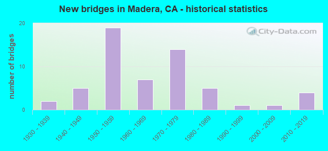
- New bridges - historical statistics
- 21930-1939
- 51940-1949
- 191950-1959
- 71960-1969
- 141970-1979
- 51980-1989
- 11990-1999
- 12000-2009
- 42010-2019
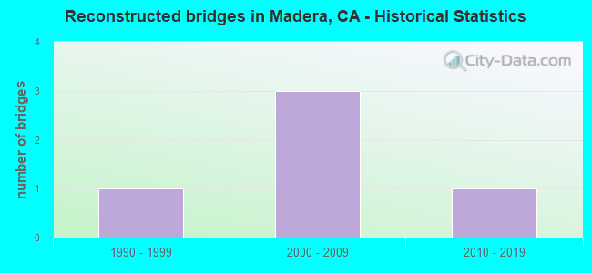
- Reconstructed bridges - Historical Statistics
- 11990-1999
- 32000-2009
- 12010-2019
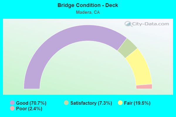
- Bridge Condition - Deck
- 70.7%Good
- 7.3%Satisfactory
- 19.5%Fair
- 2.4%Poor
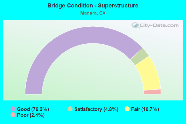
- Bridge Condition - Superstructure
- 76.2%Good
- 4.8%Satisfactory
- 16.7%Fair
- 2.4%Poor
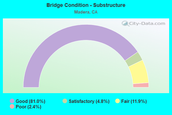
- Bridge Condition - Substructure
- 81.0%Good
- 4.8%Satisfactory
- 11.9%Fair
- 2.4%Poor
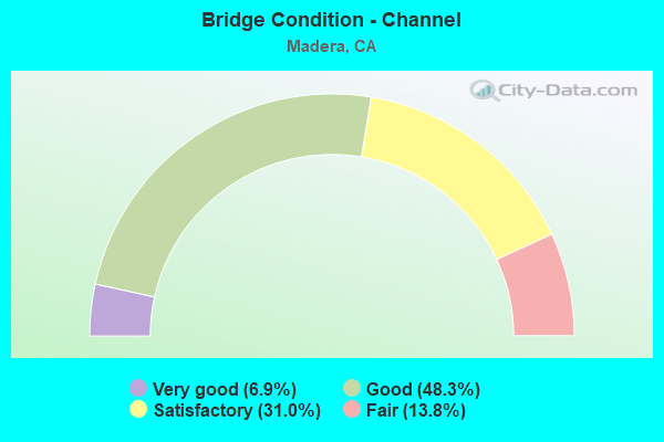
- Bridge Condition - Channel
- 6.9%Very good
- 48.3%Good
- 31.0%Satisfactory
- 13.8%Fair
Find on map >> Show street view
Structure Number: 41C0181, Location: 0.4 MI S/O AVE 15.5 (Lat: 36.967689, Lng: -120.092114), Route carried "on" structure: County highway , Year Built: 1976, Status: Open, Structure Length: 6.95m (22.80ft), Average Daily Traffic: 9,275 (year 2014), Truck Traffic: 3%, Average Future Daily Traffic: 10,442 (year 2042), Design Load: HS 20, Features Intersected: FRESNO RIVER, Facility Carried by Structure: GRANADA DR (RD 25)
Minimum Vertical Clearance: 30+ m (98+ ft), Kilometerpoint: 0.000, Lanes on structure: 2, Owner: City or Municipal Highway Agency, Approaching Roadway Width: 15.7m (51.5ft), Skew: 2 degrees, Material/Design: Concrete continuous, Design/Construction: Slab, Number Of Spans In Main Unit: 8, Length of Maximum Span: 8.5m (27.9ft), Curb-To-Curb Width: 9.1m (29.9ft), Out-to-Out Width: 9.3m (30.5ft)
Condition: Deck: Good, Superstructure: Good, Substructure: Good, Channel: Fair, Operating Rating: 57.0 metric tons, Method Used To Determine Operating Rating: Load Factor (LF), Inventory Rating: 34.3 metric tons, Method Used To Determine Inventory Rating: Load Factor (LF), Structural Evaluation: Better than present minimum criteria, Deck Geometry: Meets minimum limits, Waterway Adequacy: Equal to present desirable criteria, Approach Roadway Alignment: Better than present minimum criteria, Designated Inspection Frequency: Every 24 months, Inspection Date: January 2022, Deck Structure Type: Concrete Cast-file-Place, Wearing Surface/Protective System: Wearing Surface: Bituminous
Find on map >> Show street view
Structure Number: 41C0191, Location: 0.6 MI S OF AVE 20 (Lat: 37.034364, Lng: -120.148067), Route carried "on" structure: County highway , Year Built: 1980, Status: Open, Structure Length: 2.38m (7.81ft), Average Daily Traffic: 500 (year 1980), Truck Traffic: 10%, Average Future Daily Traffic: 709 (year 2041), Design Load: HS 20, Features Intersected: BERENDA CREEK, Facility Carried by Structure: GOLDEN STATE DR
Minimum Vertical Clearance: 30+ m (98+ ft), Kilometerpoint: 0.000, Lanes on structure: 2, Owner: County Highway Agency, Approaching Roadway Width: 11.0m (36.1ft), Material/Design: Concrete continuous, Design/Construction: Slab, Number Of Spans In Main Unit: 3, Length of Maximum Span: 12.2m (40.0ft), Curb-To-Curb Width: 11.0m (36.1ft), Out-to-Out Width: 11.2m (36.7ft)
Condition: Deck: Satisfactory, Superstructure: Satisfactory, Substructure: Good, Channel: Good, Operating Rating: 87.5 metric tons, Method Used To Determine Operating Rating: Load Factor (LF), Inventory Rating: 52.5 metric tons, Method Used To Determine Inventory Rating: Load Factor (LF), Structural Evaluation: Equal to present minimum criteria, Deck Geometry: Better than present minimum criteria, Waterway Adequacy: Equal to present desirable criteria, Approach Roadway Alignment: Better than present minimum criteria, Designated Inspection Frequency: Every 48 months, Inspection Date: March 2019, Deck Structure Type: Concrete Cast-file-Place
Find on map >> Show street view
Structure Number: 41C0199, Location: 0.5 MI N OF SUNSET AVE (Lat: 36.967947, Lng: -120.083222), Route carried "on" structure: City street , Year Built: 1993, Status: Open, Structure Length: 12.19m (39.99ft), Average Daily Traffic: 13,655 (year 2014), Truck Traffic: 3%, Average Future Daily Traffic: 7,196 (year 2042), Design Load: HS 20+Mod, Features Intersected: FRESNO RIVER, Facility Carried by Structure: SCHNOOR AVENUE
Minimum Vertical Clearance: 30+ m (98+ ft), Kilometerpoint: 0.000, Lanes on structure: 4, Owner: City or Municipal Highway Agency, Approaching Roadway Width: 14.4m (47.2ft), Material/Design: Concrete continuous, Design/Construction: Slab, Number Of Spans In Main Unit: 10, Length of Maximum Span: 12.2m (40.0ft), Curb or Sidewalk Widths: Left: 1.5m (4.9ft), Right: 1.5m (4.9ft), Curb-To-Curb Width: 15.8m (51.8ft), Out-to-Out Width: 19.5m (64.0ft)
Condition: Deck: Good, Superstructure: Good, Substructure: Good, Channel: Good, Operating Rating: 54.1 metric tons, Method Used To Determine Operating Rating: Assigned rating based on Load Factor Design (LFD) reported in metric tons, Inventory Rating: 32.4 metric tons, Method Used To Determine Inventory Rating: Assigned rating based on Load Factor Design (LFD) reported in metric tons, Structural Evaluation: Better than present minimum criteria, Deck Geometry: Meets minimum limits, Waterway Adequacy: Better than present minimum criteria, Approach Roadway Alignment: Better than present minimum criteria, Designated Inspection Frequency: Every 48 months, Inspection Date: Febuary 2020, Deck Structure Type: Concrete Cast-file-Place
Find on map >> Show street view
Structure Number: 41 0027, Location: 06-MAD-145-12.13 (Lat: 36.982717, Lng: -120.026925), Route carried "under" structure: State highway 145, Year Built: 1949, Structure Length: 0. m, Average Daily Traffic: 8,900 (year 2009), Truck Traffic: 7%, Features Intersected: SR 145, Facility Carried by Structure: BNSF RY & AMTRAK
Minimum Vertical Clearance: 4.69m (15.39ft), Kilometerpoint: 12.130, Lanes under structure: 2, Material/Design: Steel, Design/Construction: Stringer/Multi-beam, Length of Maximum Span: 11.0m (36.1ft)
Find on map >> Show street view
Structure Number: 41 0046K, Location: 06-MAD-099-9.74 (Lat: 36.948575, Lng: -120.048281), Route carried "under" structure: State highway 99, Year Built: 1958, Structure Length: 0. m, Average Daily Traffic: 61,000 (year 2009), Truck Traffic: 22%, Features Intersected: SR 99, Facility Carried by Structure: S GATEWAY DR
Minimum Vertical Clearance: 4.57m (14.99ft), Kilometerpoint: 9.740, Lanes on structure: 2, Lanes under structure: 4, Material/Design: Concrete continuous, Design/Construction: Box Beam or Girders - Multiple, Length of Maximum Span: 21.9m (71.9ft)
Find on map >> Show street view
Structure Number: 41 0047, Location: 06-MAD-145-9.07-MAD (Lat: 36.952911, Lng: -120.055925), Route carried "under" structure: State highway 99, Year Built: 1958, Structure Length: 0. m, Average Daily Traffic: 65,000 (year 2009), Truck Traffic: 19%, Features Intersected: STATE ROUTE 99, Facility Carried by Structure: SR 145 (MADERA AV)
Minimum Vertical Clearance: 4.57m (14.99ft), Kilometerpoint: 10.270, Lanes on structure: 6, Lanes under structure: 4, Material/Design: Prestressed concrete, Design/Construction: Stringer/Multi-beam, Length of Maximum Span: 22.6m (74.1ft)
Find on map >> Show street view
Structure Number: 41 0048, Location: 06-MAD-099-10.76-MAD (Lat: 36.958528, Lng: -120.062089), Route carried "under" structure: State highway 99, Year Built: 1958, Structure Length: 0. m, Average Daily Traffic: 65,000 (year 2009), Truck Traffic: 23%, Features Intersected: SR 99, Facility Carried by Structure: W SIXTH ST
Minimum Vertical Clearance: 4.62m (15.16ft), Kilometerpoint: 10.760, Lanes on structure: 2, Lanes under structure: 4, Material/Design: Concrete continuous, Design/Construction: Box Beam or Girders - Multiple, Length of Maximum Span: 16.8m (55.1ft)
Find on map >> Show street view
Structure Number: 41 0049, Location: 06-MAD-099-10.84-MAD (Lat: 36.959422, Lng: -120.063053), Route carried "under" structure: State highway 99, Year Built: 1958, Structure Length: 0. m, Average Daily Traffic: 65,000 (year 2009), Truck Traffic: 23%, Features Intersected: SR 99, Facility Carried by Structure: WEST YOSEMITE AVE
Minimum Vertical Clearance: 4.57m (14.99ft), Kilometerpoint: 10.840, Lanes on structure: 4, Lanes under structure: 5, Material/Design: Concrete continuous, Design/Construction: Box Beam or Girders - Multiple, Length of Maximum Span: 20.7m (67.9ft)
Find on map >> Show street view
Structure Number: 41 005, Location: 06-MAD-099-11.01-MAD (Lat: 36.961242, Lng: -120.064961), Route carried "under" structure: State highway 99, Year Built: 1958, Structure Length: 0. m, Average Daily Traffic: 68,000 (year 2009), Truck Traffic: 24%, Features Intersected: SR 99, Facility Carried by Structure: W FOURTH ST
Minimum Vertical Clearance: 4.59m (15.06ft), Kilometerpoint: 11.010, Lanes on structure: 5, Lanes under structure: 4, Material/Design: Concrete continuous, Design/Construction: Box Beam or Girders - Multiple, Length of Maximum Span: 16.8m (55.1ft)
Find on map >> Show street view
Structure Number: 41 0051, Location: 06-MAD-099-11.09-MAD (Lat: 36.962297, Lng: -120.065897), Route carried "under" structure: State highway 99, Year Built: 1958, Structure Length: 0. m, Average Daily Traffic: 68,000 (year 2009), Truck Traffic: 24%, Features Intersected: SR 99, Facility Carried by Structure: UP RR SPUR
Minimum Vertical Clearance: 5.08m (16.67ft), Kilometerpoint: 11.090, Lanes under structure: 4, Material/Design: Steel, Design/Construction: Girder and Floorbeam System, Length of Maximum Span: 16.8m (55.1ft)
Find on map >> Show street view
Structure Number: 41 0053, Location: 06-MAD-099-12.13-MAD (Lat: 36.974508, Lng: -120.076633), Route carried "under" structure: State highway 99, Year Built: 1958, Structure Length: 0. m, Average Daily Traffic: 68,000 (year 2009), Truck Traffic: 24%, Features Intersected: SR 99, Facility Carried by Structure: CLEVELAND AVE
Minimum Vertical Clearance: 4.59m (15.06ft), Kilometerpoint: 12.130, Lanes on structure: 5, Lanes under structure: 4, Material/Design: Prestressed concrete continuous, Design/Construction: Box Beam or Girders - Multiple, Length of Maximum Span: 23.5m (77.1ft)
Find on map >> Show street view
Structure Number: 41 0058, Location: 06-MAD-099-12.75-MAD (Lat: 36.981364, Lng: -120.084333), Route carried "under" structure: State highway 99, Year Built: 1958, Structure Length: 0. m, Average Daily Traffic: 68,000 (year 2009), Truck Traffic: 24%, Features Intersected: SR 99, Facility Carried by Structure: N GATEWAY DR
Minimum Vertical Clearance: 4.67m (15.32ft), Kilometerpoint: 12.750, Lanes on structure: 2, Lanes under structure: 5, Material/Design: Concrete continuous, Design/Construction: Box Beam or Girders - Multiple, Length of Maximum Span: 29.6m (97.1ft)
Find on map >> Show street view
Structure Number: 41 0062, Location: 06-MAD-099-8.72 (Lat: 36.938064, Lng: -120.036436), Route carried "under" structure: State highway 99, Year Built: 1967, Structure Length: 0. m, Average Daily Traffic: 67,000 (year 2009), Truck Traffic: 9%, Features Intersected: SR 99 & UP RR, Facility Carried by Structure: AVENUE 13
Minimum Vertical Clearance: 6.60m (21.65ft), Kilometerpoint: 8.720, Lanes on structure: 2, Lanes under structure: 4, Material/Design: Concrete continuous, Design/Construction: Box Beam or Girders - Multiple, Length of Maximum Span: 28.7m (94.2ft)
Find on map >> Show street view
Structure Number: 41 0068, Location: 06-MAD-099-R14.22 (Lat: 36.996411, Lng: -120.102819), Route carried "under" structure: State highway 99, Year Built: 1973, Structure Length: 0. m, Average Daily Traffic: 58,000 (year 2009), Features Intersected: SR 99, Facility Carried by Structure: AVENUE 17
Minimum Vertical Clearance: 5.21m (17.09ft), Kilometerpoint: 14.220, Lanes on structure: 2, Lanes under structure: 5, Material/Design: Prestressed concrete continuous, Design/Construction: Box Beam or Girders - Multiple, Length of Maximum Span: 51.5m (169.0ft)
Find on map >> Show street view
Structure Number: 41 0069, Location: 06-MAD-099-R16.33 (Lat: 37.018164, Lng: -120.129392), Route carried "under" structure: State highway 99, Year Built: 1974, Structure Length: 0. m, Average Daily Traffic: 56,000 (year 2009), Truck Traffic: 24%, Features Intersected: SR 99, Facility Carried by Structure: AVENUE 18 1/2
Minimum Vertical Clearance: 5.10m (16.73ft), Kilometerpoint: 16.330, Lanes on structure: 3, Lanes under structure: 4, Material/Design: Prestressed concrete continuous, Design/Construction: Box Beam or Girders - Multiple, Length of Maximum Span: 53.0m (173.9ft)
Find on map >> Show street view
Structure Number: 41 0085, Location: 06-MAD-099-13.07-MAD (Lat: 36.984422, Lng: -120.088106), Route carried "under" structure: State highway 99, Year Built: 2012, Structure Length: 0. m, Average Daily Traffic: 61,000 (year 2009), Truck Traffic: 24%, Features Intersected: SR 99, UP RR, GOLDEN STA, Facility Carried by Structure: ELLIS ST
Minimum Vertical Clearance: 7.50m (24.61ft), Kilometerpoint: 13.070, Lanes on structure: 4, Lanes under structure: 4, Material/Design: Prestressed concrete continuous, Design/Construction: Box Beam or Girders - Multiple, Length of Maximum Span: 38.5m (126.3ft)
Find on map >> Show street view
Structure Number: 41 0085, Location: 06-MAD-099-13.07-MAD (Lat: 36.984422, Lng: -120.088106), Route carried "under" structure: County highway , Year Built: 2012, Structure Length: 0. m, Average Daily Traffic: 5,000 (year 2009), Truck Traffic: 1%, Features Intersected: SR 99, UP RR, GOLDEN STA, Facility Carried by Structure: ELLIS ST
Minimum Vertical Clearance: 7.78m (25.52ft), Kilometerpoint: 0.000, Lanes on structure: 4, Lanes under structure: 2, Material/Design: Prestressed concrete continuous, Design/Construction: Box Beam or Girders - Multiple, Length of Maximum Span: 38.5m (126.3ft)
Find on map >> Show street view
Structure Number: 41 0085, Location: 06-MAD-099-13.07-MAD (Lat: 36.984422, Lng: -120.088106), Route carried "under" structure: City street , Year Built: 2012, Structure Length: 0. m, Average Daily Traffic: 1,000 (year 2009), Truck Traffic: 1%, Features Intersected: SR 99, UP RR, GOLDEN STA, Facility Carried by Structure: ELLIS ST
Minimum Vertical Clearance: 7.52m (24.67ft), Kilometerpoint: 0.000, Lanes on structure: 4, Lanes under structure: 2, Material/Design: Prestressed concrete continuous, Design/Construction: Box Beam or Girders - Multiple, Length of Maximum Span: 38.5m (126.3ft)