Bridge Statistics for Macon, Mississippi (MS)
Condition, Traffic, Stress, Structural Evaluation, Project Costs
- National Bridge Inventory (NBI) Statistics
- 43Number of bridges
- 863ft / 263mTotal length
- $1,779,811,000Total costs
- 60,810Total average daily traffic
- 10,363Total average daily truck traffic
- 69,750Total future (year 2040) average daily traffic
- National Bridge Inventory (NBI) Registered Bridges for Macon
- No street view available for this location
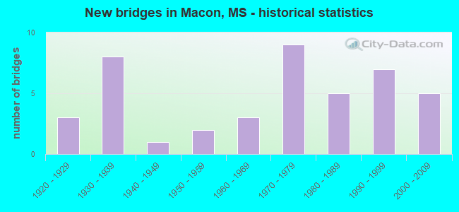
- New bridges - historical statistics
- 31920-1929
- 81930-1939
- 11940-1949
- 21950-1959
- 31960-1969
- 91970-1979
- 51980-1989
- 71990-1999
- 52000-2009


- Bridge Condition - Deck
- 12.8%Very good
- 38.5%Good
- 23.1%Satisfactory
- 23.1%Fair
- 2.6%Failed

- Bridge Condition - Superstructure
- 38.5%Very good
- 25.6%Good
- 12.8%Satisfactory
- 17.9%Fair
- 2.6%Poor
- 2.6%Failed

- Bridge Condition - Substructure
- 30.8%Very good
- 28.2%Good
- 30.8%Satisfactory
- 5.1%Fair
- 2.6%Serious
- 2.6%Failed

- Bridge Condition - Channel
- 25.6%Very good
- 30.2%Good
- 20.9%Satisfactory
- 18.6%Fair
- 4.7%Poor

- Bridge Condition - Culverts
- 25.0%Very good
- 50.0%Satisfactory
- 25.0%Fair
Find on map >> Show street view
Structure Number: 21000450521283A, Location: 5.1 MI N SR 39 (Lat: 33.052367, Lng: -88.563775), Route carried "on" structure: US 45, Year Built: 1998, Status: Open, Structure Length: 7.36m (24.15ft), Average Daily Traffic: 3,100 (year 2020), Truck Traffic: 26%, Average Future Daily Traffic: 3,300 (year 2040), Design Load: HS 20, Features Intersected: DRY CREEK
Minimum Vertical Clearance: 30+ m (98+ ft), Kilometerpoint: 26.979, Lanes on structure: 2, Base Highway Network: Yes (Inventory Route: 4, Subroute: 1), Owner: State Highway Agency, Approaching Roadway Width: 12.2m (40.0ft), Skew: 10 degrees, Material/Design: Prestressed concrete, Design/Construction: Stringer/Multi-beam, Number Of Spans In Main Unit: 1, Number Of Approach Spans: 4, Length of Maximum Span: 24.4m (80.1ft), Curb-To-Curb Width: 12.2m (40.0ft), Out-to-Out Width: 13.1m (43.0ft)
Condition: Deck: Good, Superstructure: Very good, Substructure: Very good, Channel: Good, Operating Rating: 54.8 metric tons, Method Used To Determine Operating Rating: Load Factor (LF), Inventory Rating: 26.8 metric tons, Method Used To Determine Inventory Rating: Load Factor (LF), Structural Evaluation: Equal to present minimum criteria, Deck Geometry: Better than present minimum criteria, Waterway Adequacy: Equal to present desirable criteria, Approach Roadway Alignment: Equal to present desirable criteria, Designated Inspection Frequency: Every 24 months, Inspection Date: November 2021, Deck Structure Type: Concrete Cast-file-Place
Find on map >> Show street view
Structure Number: 21000450521283B, Location: 5.1 MI N SR 39 (Lat: 33.051697, Lng: -88.563486), Route carried "on" structure: US 45, Year Built: 1996, Status: Open, Structure Length: 7.38m (24.21ft), Average Daily Traffic: 2,650 (year 2020), Truck Traffic: 31%, Average Future Daily Traffic: 2,850 (year 2040), Design Load: HS 20, Features Intersected: DRY CREEK
Minimum Vertical Clearance: 30+ m (98+ ft), Kilometerpoint: 14.420, Lanes on structure: 2, Base Highway Network: Yes (Inventory Route: 4, Subroute: 1), Owner: State Highway Agency, Approaching Roadway Width: 13.4m (44.0ft), Skew: 10 degrees, Material/Design: Prestressed concrete, Design/Construction: Stringer/Multi-beam, Number Of Spans In Main Unit: 1, Number Of Approach Spans: 4, Length of Maximum Span: 24.4m (80.1ft), Curb-To-Curb Width: 12.2m (40.0ft), Out-to-Out Width: 13.0m (42.7ft)
Condition: Deck: Very good, Superstructure: Very good, Substructure: Very good, Channel: Good, Operating Rating: 55.2 metric tons, Method Used To Determine Operating Rating: Load Factor (LF), Inventory Rating: 26.8 metric tons, Method Used To Determine Inventory Rating: Load Factor (LF), Structural Evaluation: Equal to present minimum criteria, Deck Geometry: Better than present minimum criteria, Waterway Adequacy: Equal to present desirable criteria, Approach Roadway Alignment: Equal to present desirable criteria, Designated Inspection Frequency: Every 24 months, Inspection Date: November 2021, Deck Structure Type: Concrete Cast-file-Place
Find on map >> Show street view
Structure Number: 21000450521297, Location: 6.4 MI N SR 39 (Lat: 33.074175, Lng: -88.558086), Route carried "on" structure: US 45, Year Built: 1974, Status: Open, Structure Length: 32.00m (104.99ft), Average Daily Traffic: 2,600 (year 2020), Truck Traffic: 20%, Average Future Daily Traffic: 5,000 (year 2040), Design Load: HS 20, Features Intersected: NOXUBEE RIVER
Minimum Vertical Clearance: 30+ m (98+ ft), Kilometerpoint: 24.451, Lanes on structure: 2, Base Highway Network: Yes (Inventory Route: 4, Subroute: 1), Owner: State Highway Agency, Approaching Roadway Width: 13.4m (44.0ft), Material/Design: Prestressed concrete, Design/Construction: Stringer/Multi-beam, Number Of Spans In Main Unit: 1, Number Of Approach Spans: 21, Length of Maximum Span: 33.5m (109.9ft), Curb-To-Curb Width: 12.4m (40.7ft), Out-to-Out Width: 13.4m (44.0ft)
Condition: Deck: Good, Superstructure: Very good, Substructure: Good, Channel: Good, Operating Rating: 59.9 metric tons, Method Used To Determine Operating Rating: Load Factor (LF), Inventory Rating: 29.2 metric tons, Method Used To Determine Inventory Rating: Load Factor (LF), Structural Evaluation: Better than present minimum criteria, Deck Geometry: Better than present minimum criteria, Waterway Adequacy: Equal to present desirable criteria, Approach Roadway Alignment: Equal to present desirable criteria, Designated Inspection Frequency: Every 24 months, Inspection Date: November 2021, Deck Structure Type: Concrete Cast-file-Place
Find on map >> Show street view
Structure Number: 21000450521297B, Location: 6.4 MI N SR 39 (Lat: 33.071472, Lng: -88.559244), Route carried "on" structure: US 45, Year Built: 1992, Status: Open, Structure Length: 32.06m (105.18ft), Average Daily Traffic: 3,100 (year 2020), Truck Traffic: 26%, Average Future Daily Traffic: 3,300 (year 2040), Design Load: HS 20, Features Intersected: NOXUBEE RIVER
Minimum Vertical Clearance: 30+ m (98+ ft), Kilometerpoint: 16.694, Lanes on structure: 2, Base Highway Network: Yes (Inventory Route: 4, Subroute: 1), Owner: State Highway Agency, Approaching Roadway Width: 13.4m (44.0ft), Skew: 3 degrees, Material/Design: Prestressed concrete continuous, Design/Construction: Stringer/Multi-beam, Number Of Spans In Main Unit: 3, Number Of Approach Spans: 18, Length of Maximum Span: 33.5m (109.9ft), Curb-To-Curb Width: 12.2m (40.0ft), Out-to-Out Width: 13.0m (42.7ft)
Condition: Deck: Fair, Superstructure: Very good, Substructure: Very good, Channel: Good, Operating Rating: 57.4 metric tons, Method Used To Determine Operating Rating: Load Factor (LF), Inventory Rating: 34.4 metric tons, Method Used To Determine Inventory Rating: Load Factor (LF), Structural Evaluation: Equal to present desirable criteria, Deck Geometry: Better than present minimum criteria, Waterway Adequacy: Equal to present desirable criteria, Approach Roadway Alignment: Equal to present desirable criteria, Designated Inspection Frequency: Every 24 months, Inspection Date: November 2021, Deck Structure Type: Concrete Cast-file-Place
Find on map >> Show street view
Structure Number: 21000450521332, Location: 1.0 MI N SR 14 (Lat: 33.120297, Lng: -88.547539), Route carried "on" structure: US 45, Year Built: 1975, Status: Open, Structure Length: 0.91m (2.99ft), Average Daily Traffic: 6,400 (year 2020), Truck Traffic: 24%, Average Future Daily Traffic: 6,800 (year 2040), Design Load: HS 20, Features Intersected: CLEAR CREEK
Minimum Vertical Clearance: 30+ m (98+ ft), Kilometerpoint: 22.338, Lanes on structure: 4, Base Highway Network: Yes (Inventory Route: 4, Subroute: 1), Owner: State Highway Agency, Approaching Roadway Width: 13.4m (44.0ft), Skew: 13 degrees, Material/Design: Concrete, Design/Construction: Culvert, Number Of Spans In Main Unit: 2, Length of Maximum Span: 3.7m (12.1ft)
Condition: Channel: Good, Culverts: Very good, Structural Evaluation: Equal to present desirable criteria, Waterway Adequacy: Equal to present desirable criteria, Approach Roadway Alignment: Equal to present desirable criteria, Designated Inspection Frequency: Every 24 months, Inspection Date: November 2021
Find on map >> Show street view
Structure Number: 21000450521369, Location: 4.5 MI N SR 14 (Lat: 33.168886, Lng: -88.563097), Route carried "on" structure: US 45, Year Built: 1974, Status: Open, Structure Length: 7.68m (25.20ft), Average Daily Traffic: 2,600 (year 2020), Truck Traffic: 17%, Average Future Daily Traffic: 3,400 (year 2040), Design Load: HS 20, Features Intersected: HORSE HUNTERS CREEK
Minimum Vertical Clearance: 30+ m (98+ ft), Kilometerpoint: 13.465, Lanes on structure: 2, Base Highway Network: Yes (Inventory Route: 4, Subroute: 1), Owner: State Highway Agency, Approaching Roadway Width: 13.4m (44.0ft), Material/Design: Prestressed concrete, Design/Construction: Stringer/Multi-beam, Number Of Spans In Main Unit: 5, Length of Maximum Span: 15.2m (49.9ft), Curb-To-Curb Width: 12.4m (40.7ft), Out-to-Out Width: 13.4m (44.0ft)
Condition: Deck: Very good, Superstructure: Good, Substructure: Good, Channel: Good, Operating Rating: 62.9 metric tons, Method Used To Determine Operating Rating: Load Factor (LF), Inventory Rating: 34.8 metric tons, Method Used To Determine Inventory Rating: Load Factor (LF), Structural Evaluation: Better than present minimum criteria, Deck Geometry: Better than present minimum criteria, Waterway Adequacy: Equal to present desirable criteria, Approach Roadway Alignment: Equal to present desirable criteria, Designated Inspection Frequency: Every 24 months, Inspection Date: November 2021, Deck Structure Type: Concrete Cast-file-Place, Wearing Surface/Protective System: Wearing Surface: Epoxy Overlay
Find on map >> Show street view
Structure Number: 21000450521369B, Location: 4.5 MI N SR 14 (Lat: 33.168394, Lng: -88.562458), Route carried "on" structure: US 45, Year Built: 1992, Status: Open, Structure Length: 7.68m (25.20ft), Average Daily Traffic: 5,500 (year 2020), Truck Traffic: 22%, Average Future Daily Traffic: 5,500 (year 2040), Design Load: HS 20, Features Intersected: HORSE HUNTERS CREEK
Minimum Vertical Clearance: 30+ m (98+ ft), Kilometerpoint: 27.945, Lanes on structure: 2, Base Highway Network: Yes (Inventory Route: 4, Subroute: 1), Owner: State Highway Agency, Approaching Roadway Width: 13.4m (44.0ft), Material/Design: Prestressed concrete continuous, Design/Construction: Stringer/Multi-beam, Number Of Spans In Main Unit: 5, Length of Maximum Span: 15.2m (49.9ft), Curb-To-Curb Width: 12.4m (40.7ft), Out-to-Out Width: 13.0m (42.7ft)
Condition: Deck: Good, Superstructure: Very good, Substructure: Very good, Channel: Good, Operating Rating: 54.1 metric tons, Method Used To Determine Operating Rating: Load Factor (LF), Inventory Rating: 29.7 metric tons, Method Used To Determine Inventory Rating: Load Factor (LF), Structural Evaluation: Better than present minimum criteria, Deck Geometry: Better than present minimum criteria, Waterway Adequacy: Equal to present desirable criteria, Approach Roadway Alignment: Equal to present desirable criteria, Designated Inspection Frequency: Every 24 months, Inspection Date: November 2021, Deck Structure Type: Concrete Cast-file-Place
Find on map >> Show street view
Structure Number: 31000140521625, Location: 13.5 MI E WINSTON CL (Lat: 33.088711, Lng: -88.581664), Route carried "on" structure: State highway 14, Year Built: 2002, Status: Open, Structure Length: 6.00m (19.69ft), Average Daily Traffic: 2,400 (year 2020), Truck Traffic: 14%, Average Future Daily Traffic: 2,400 (year 2040), Design Load: HS 20, Features Intersected: NOXUBEE RIVER RELIEF
Minimum Vertical Clearance: 30+ m (98+ ft), Kilometerpoint: 22.227, Lanes on structure: 2, Base Highway Network: Yes (Inventory Route: 1, Subroute: 1), Owner: State Highway Agency, Approaching Roadway Width: 13.2m (43.3ft), Material/Design: Prestressed concrete, Design/Construction: Stringer/Multi-beam, Number Of Spans In Main Unit: 5, Length of Maximum Span: 12.0m (39.4ft), Curb-To-Curb Width: 13.2m (43.3ft), Out-to-Out Width: 14.1m (46.3ft)
Condition: Deck: Very good, Superstructure: Very good, Substructure: Very good, Channel: Very good, Operating Rating: 53.7 metric tons, Method Used To Determine Operating Rating: Load Factor (LF), Inventory Rating: 32.1 metric tons, Method Used To Determine Inventory Rating: Load Factor (LF), Structural Evaluation: Better than present minimum criteria, Deck Geometry: Equal to present minimum criteria, Waterway Adequacy: Equal to present desirable criteria, Approach Roadway Alignment: Equal to present desirable criteria, Designated Inspection Frequency: Every 24 months, Inspection Date: November 2021, Deck Structure Type: Concrete Cast-file-Place
Find on map >> Show street view
Structure Number: 31000140521629, Location: 14.0 MI E WINSTON CL (Lat: 33.090561, Lng: -88.576392), Route carried "on" structure: State highway 14, Year Built: 2002, Status: Open, Structure Length: 18.00m (59.06ft), Average Daily Traffic: 2,400 (year 2020), Truck Traffic: 14%, Average Future Daily Traffic: 2,400 (year 2040), Design Load: HS 20, Features Intersected: NOXUBEE RIVER RELIEF
Minimum Vertical Clearance: 30+ m (98+ ft), Kilometerpoint: 22.763, Lanes on structure: 2, Base Highway Network: Yes (Inventory Route: 1, Subroute: 1), Owner: State Highway Agency, Approaching Roadway Width: 13.2m (43.3ft), Material/Design: Prestressed concrete continuous, Design/Construction: Stringer/Multi-beam, Number Of Spans In Main Unit: 15, Length of Maximum Span: 12.0m (39.4ft), Curb-To-Curb Width: 13.2m (43.3ft), Out-to-Out Width: 14.1m (46.3ft)
Condition: Deck: Good, Superstructure: Very good, Substructure: Very good, Channel: Very good, Operating Rating: 54.1 metric tons, Method Used To Determine Operating Rating: Load Factor (LF), Inventory Rating: 32.4 metric tons, Method Used To Determine Inventory Rating: Load Factor (LF), Structural Evaluation: Equal to present desirable criteria, Deck Geometry: Equal to present minimum criteria, Waterway Adequacy: Equal to present desirable criteria, Approach Roadway Alignment: Equal to present desirable criteria, Designated Inspection Frequency: Every 24 months, Inspection Date: November 2021, Deck Structure Type: Concrete Cast-file-Place
Find on map >> Show street view
Structure Number: 31000140521635, Location: 14..6 MI E WINSTON CL (Lat: 33.095028, Lng: -88.568061), Route carried "on" structure: State highway 14, Year Built: 2002, Status: Open, Structure Length: 12.00m (39.37ft), Average Daily Traffic: 2,400 (year 2020), Truck Traffic: 14%, Average Future Daily Traffic: 2,400 (year 2040), Design Load: HS 20, Features Intersected: NOXUBEE RIVER RELIEF
Minimum Vertical Clearance: 30+ m (98+ ft), Kilometerpoint: 23.685, Lanes on structure: 2, Base Highway Network: Yes (Inventory Route: 1, Subroute: 1), Owner: State Highway Agency, Approaching Roadway Width: 13.2m (43.3ft), Material/Design: Prestressed concrete continuous, Design/Construction: Stringer/Multi-beam, Number Of Spans In Main Unit: 10, Length of Maximum Span: 12.0m (39.4ft), Curb-To-Curb Width: 13.2m (43.3ft), Out-to-Out Width: 14.1m (46.3ft)
Condition: Deck: Good, Superstructure: Very good, Substructure: Very good, Channel: Very good, Operating Rating: 54.1 metric tons, Method Used To Determine Operating Rating: Load Factor (LF), Inventory Rating: 32.4 metric tons, Method Used To Determine Inventory Rating: Load Factor (LF), Structural Evaluation: Equal to present desirable criteria, Deck Geometry: Equal to present minimum criteria, Waterway Adequacy: Equal to present desirable criteria, Approach Roadway Alignment: Equal to present desirable criteria, Designated Inspection Frequency: Every 24 months, Inspection Date: November 2021, Deck Structure Type: Concrete Cast-file-Place
Find on map >> Show street view
Structure Number: 31000140521637, Location: 14.8 MI E WINSTON CL (Lat: 33.096814, Lng: -88.564450), Route carried "on" structure: State highway 14, Year Built: 2002, Status: Open, Structure Length: 6.00m (19.69ft), Average Daily Traffic: 2,400 (year 2020), Truck Traffic: 14%, Average Future Daily Traffic: 2,400 (year 2040), Design Load: HS 20, Features Intersected: NOXUBEEE RIVER RELIEF
Minimum Vertical Clearance: 30+ m (98+ ft), Kilometerpoint: 24.076, Lanes on structure: 2, Base Highway Network: Yes (Inventory Route: 1, Subroute: 1), Owner: State Highway Agency, Approaching Roadway Width: 13.2m (43.3ft), Material/Design: Prestressed concrete, Design/Construction: Stringer/Multi-beam, Number Of Spans In Main Unit: 5, Length of Maximum Span: 12.0m (39.4ft), Curb-To-Curb Width: 13.2m (43.3ft), Out-to-Out Width: 14.1m (46.3ft)
Condition: Deck: Good, Superstructure: Very good, Substructure: Very good, Channel: Very good, Operating Rating: 53.0 metric tons, Method Used To Determine Operating Rating: Load Factor (LF), Inventory Rating: 31.7 metric tons, Method Used To Determine Inventory Rating: Load Factor (LF), Structural Evaluation: Better than present minimum criteria, Deck Geometry: Equal to present minimum criteria, Waterway Adequacy: Equal to present desirable criteria, Approach Roadway Alignment: Equal to present desirable criteria, Designated Inspection Frequency: Every 24 months, Inspection Date: November 2021, Deck Structure Type: Concrete Cast-file-Place
Find on map >> Show street view
Structure Number: 3100014052164, Location: 0.3 MI N SR 14 WEST (Lat: 33.101292, Lng: -88.561697), Route carried "on" structure: State highway 14, Year Built: 1935, Status: Open, Structure Length: 12.19m (39.99ft), Average Daily Traffic: 3,300 (year 2020), Truck Traffic: 15%, Average Future Daily Traffic: 3,300 (year 2040), Design Load: H 15, Features Intersected: NOXUBEE RIVER
Minimum Vertical Clearance: 30+ m (98+ ft), Kilometerpoint: 24.777, Lanes on structure: 2, Base Highway Network: Yes (Inventory Route: 1, Subroute: 1), Owner: State Highway Agency, Approaching Roadway Width: 9.1m (29.9ft), Skew: 6 degrees, Material/Design: Steel continuous, Design/Construction: Stringer/Multi-beam, Number Of Spans In Main Unit: 3, Number Of Approach Spans: 4, Length of Maximum Span: 47.5m (155.8ft), Curb or Sidewalk Widths: Left: 0.2m (0.7ft), Right: 0.2m (0.7ft), Curb-To-Curb Width: 7.7m (25.3ft), Out-to-Out Width: 8.0m (26.2ft)
Condition: Deck: Fair, Superstructure: Poor, Substructure: Fair, Channel: Fair, Operating Rating: 55.7 metric tons, Method Used To Determine Operating Rating: Load Factor (LF), Inventory Rating: 33.4 metric tons, Method Used To Determine Inventory Rating: Load Factor (LF), Structural Evaluation: Meets minimum limits, Deck Geometry: High priority of replacement, Waterway Adequacy: Equal to present desirable criteria, Approach Roadway Alignment: Equal to present desirable criteria, Length Of Structure Improvement: 15.37m (50.43ft), Designated Inspection Frequency: Every 24 months, Inspection Date: July 2021, Bridge Improvement Cost: $999,999,000, Roadway Improvement Cost: $145,000,000, Total Project Cost: $999,999,000, Deck Structure Type: Concrete Cast-file-Place, Wearing Surface/Protective System: Wearing Surface: Bituminous
Find on map >> Show street view
Structure Number: 3100014052165, Location: 0.5 MI W US 45 (Lat: 33.104906, Lng: -88.556564), Route carried "on" structure: State highway 14, Year Built: 1959, Status: Open, Structure Length: 1.86m (6.10ft), Average Daily Traffic: 3,800 (year 2020), Truck Traffic: 14%, Average Future Daily Traffic: 3,800 (year 2040), Design Load: H 15, Features Intersected: CEDAR CREEK
Minimum Vertical Clearance: 30+ m (98+ ft), Kilometerpoint: 25.663, Lanes on structure: 2, Base Highway Network: Yes (Inventory Route: 1, Subroute: 1), Owner: State Highway Agency, Approaching Roadway Width: 10.4m (34.1ft), Skew: 4 degrees, Material/Design: Concrete, Design/Construction: Culvert, Number Of Spans In Main Unit: 2, Length of Maximum Span: 6.1m (20.0ft)
Condition: Channel: Very good, Culverts: Satisfactory, Structural Evaluation: Equal to present minimum criteria, Waterway Adequacy: Equal to present desirable criteria, Approach Roadway Alignment: Better than present minimum criteria, Designated Inspection Frequency: Every 24 months, Inspection Date: November 2021
Find on map >> Show street view
Structure Number: 31000140521668, Location: 1.3 MI E US 45 (Lat: 33.101286, Lng: -88.524267), Route carried "on" structure: State highway 14, Year Built: 1959, Status: Open, Structure Length: 8.23m (27.00ft), Average Daily Traffic: 1,200 (year 2020), Truck Traffic: 20%, Average Future Daily Traffic: 1,200 (year 2040), Design Load: H 20, Features Intersected: PLUM CREEK
Minimum Vertical Clearance: 30+ m (98+ ft), Kilometerpoint: 28.775, Lanes on structure: 2, Base Highway Network: Yes (Inventory Route: 1, Subroute: 1), Owner: State Highway Agency, Approaching Roadway Width: 11.0m (36.1ft), Material/Design: Prestressed concrete, Design/Construction: Stringer/Multi-beam, Number Of Spans In Main Unit: 4, Length of Maximum Span: 20.4m (66.9ft), Curb-To-Curb Width: 7.9m (25.9ft), Out-to-Out Width: 8.8m (28.9ft)
Condition: Deck: Fair, Superstructure: Good, Substructure: Good, Channel: Very good, Operating Rating: 87.5 metric tons, Method Used To Determine Operating Rating: Load Factor (LF), Inventory Rating: 44.8 metric tons, Method Used To Determine Inventory Rating: Load Factor (LF), Structural Evaluation: Better than present minimum criteria, Deck Geometry: Meets minimum limits, Waterway Adequacy: Equal to present desirable criteria, Approach Roadway Alignment: Equal to present desirable criteria, Length Of Structure Improvement: 8.23m (27.00ft), Designated Inspection Frequency: Every 24 months, Inspection Date: November 2021, Bridge Improvement Cost: $438,000,000, Roadway Improvement Cost: $200,000,000, Total Project Cost: $765,000,000, Deck Structure Type: Concrete Cast-file-Place
Find on map >> Show street view
Structure Number: 31001450521295, Location: 2.0 MI S SR 14 WEST (Lat: 33.069025, Lng: -88.563867), Route carried "on" structure: State highway 145, Year Built: 1937, Status: Open, Structure Length: 6.40m (21.00ft), Average Daily Traffic: 710 (year 2020), Truck Traffic: 11%, Average Future Daily Traffic: 710 (year 2040), Design Load: H 15, Features Intersected: NOXUBEE RELIEF
Minimum Vertical Clearance: 30+ m (98+ ft), Kilometerpoint: 7.379, Lanes on structure: 2, Owner: State Highway Agency, Approaching Roadway Width: 7.3m (24.0ft), Material/Design: Steel, Design/Construction: Stringer/Multi-beam, Number Of Spans In Main Unit: 7, Length of Maximum Span: 9.1m (29.9ft), Curb or Sidewalk Widths: Left: 0.2m (0.7ft), Right: 0.2m (0.7ft), Curb-To-Curb Width: 7.3m (24.0ft), Out-to-Out Width: 8.3m (27.2ft)
Condition: Deck: Fair, Superstructure: Fair, Substructure: Satisfactory, Channel: Very good, Operating Rating: 50.4 metric tons, Method Used To Determine Operating Rating: Load Factor (LF), Inventory Rating: 30.2 metric tons, Method Used To Determine Inventory Rating: Load Factor (LF), Structural Evaluation: Somewhat better than minimum adequacy, Deck Geometry: Meets minimum limits, Waterway Adequacy: Equal to present desirable criteria, Approach Roadway Alignment: Better than present minimum criteria, Designated Inspection Frequency: Every 24 months, Inspection Date: November 2021, Deck Structure Type: Concrete Cast-file-Place, Wearing Surface/Protective System: Wearing Surface: Bituminous
Find on map >> Show street view
Structure Number: 31001450521299, Location: 1.6 MI S SR 14 WEST (Lat: 33.075472, Lng: -88.563903), Route carried "on" structure: State highway 145, Year Built: 1937, Status: Open, Structure Length: 2.73m (8.96ft), Average Daily Traffic: 710 (year 2020), Truck Traffic: 11%, Average Future Daily Traffic: 710 (year 2040), Design Load: H 15, Features Intersected: NOXUBEE RELIEF
Minimum Vertical Clearance: 30+ m (98+ ft), Kilometerpoint: 8.093, Lanes on structure: 2, Owner: State Highway Agency, Approaching Roadway Width: 7.3m (24.0ft), Material/Design: Steel, Design/Construction: Stringer/Multi-beam, Number Of Spans In Main Unit: 3, Length of Maximum Span: 9.1m (29.9ft), Curb or Sidewalk Widths: Left: 0.2m (0.7ft), Right: 0.2m (0.7ft), Curb-To-Curb Width: 7.3m (24.0ft), Out-to-Out Width: 8.3m (27.2ft)
Condition: Deck: Fair, Superstructure: Fair, Substructure: Satisfactory, Channel: Very good, Operating Rating: 50.4 metric tons, Method Used To Determine Operating Rating: Load Factor (LF), Inventory Rating: 30.2 metric tons, Method Used To Determine Inventory Rating: Load Factor (LF), Structural Evaluation: Somewhat better than minimum adequacy, Deck Geometry: Meets minimum limits, Waterway Adequacy: Equal to present desirable criteria, Approach Roadway Alignment: Better than present minimum criteria, Designated Inspection Frequency: Every 24 months, Inspection Date: November 2021, Deck Structure Type: Concrete Cast-file-Place, Wearing Surface/Protective System: Wearing Surface: Bituminous
Find on map >> Show street view
Structure Number: 31001450521303, Location: 1.3 MI S SR 14 WEST (Lat: 33.080556, Lng: -88.563672), Route carried "on" structure: State highway 145, Year Built: 1937, Status: Open, Structure Length: 6.37m (20.90ft), Average Daily Traffic: 710 (year 2020), Truck Traffic: 11%, Average Future Daily Traffic: 710 (year 2040), Design Load: H 15, Features Intersected: NOXUBEE RELIEF
Minimum Vertical Clearance: 30+ m (98+ ft), Kilometerpoint: 8.657, Lanes on structure: 2, Owner: State Highway Agency, Approaching Roadway Width: 7.3m (24.0ft), Material/Design: Steel, Design/Construction: Stringer/Multi-beam, Number Of Spans In Main Unit: 7, Length of Maximum Span: 9.1m (29.9ft), Curb or Sidewalk Widths: Left: 0.2m (0.7ft), Right: 0.2m (0.7ft), Curb-To-Curb Width: 7.3m (24.0ft), Out-to-Out Width: 8.3m (27.2ft)
Condition: Deck: Fair, Superstructure: Fair, Substructure: Satisfactory, Channel: Very good, Operating Rating: 50.4 metric tons, Method Used To Determine Operating Rating: Load Factor (LF), Inventory Rating: 30.2 metric tons, Method Used To Determine Inventory Rating: Load Factor (LF), Structural Evaluation: Somewhat better than minimum adequacy, Deck Geometry: Meets minimum limits, Waterway Adequacy: Equal to present desirable criteria, Approach Roadway Alignment: Better than present minimum criteria, Designated Inspection Frequency: Every 24 months, Inspection Date: November 2021, Deck Structure Type: Concrete Cast-file-Place, Wearing Surface/Protective System: Wearing Surface: Bituminous
Find on map >> Show street view
Structure Number: 31001450521305, Location: 1.1 MI S SR 14 WEST (Lat: 33.083539, Lng: -88.563386), Route carried "on" structure: State highway 145, Year Built: 1937, Status: Open, Structure Length: 7.28m (23.88ft), Average Daily Traffic: 710 (year 2020), Truck Traffic: 11%, Average Future Daily Traffic: 710 (year 2040), Design Load: H 15, Features Intersected: NOXUBEE RELIEF
Minimum Vertical Clearance: 30+ m (98+ ft), Kilometerpoint: 8.988, Lanes on structure: 2, Owner: State Highway Agency, Approaching Roadway Width: 7.3m (24.0ft), Material/Design: Steel, Design/Construction: Stringer/Multi-beam, Number Of Spans In Main Unit: 8, Length of Maximum Span: 9.1m (29.9ft), Curb or Sidewalk Widths: Left: 0.2m (0.7ft), Right: 0.2m (0.7ft), Curb-To-Curb Width: 7.3m (24.0ft), Out-to-Out Width: 8.3m (27.2ft)
Condition: Deck: Fair, Superstructure: Fair, Substructure: Satisfactory, Channel: Very good, Operating Rating: 50.4 metric tons, Method Used To Determine Operating Rating: Load Factor (LF), Inventory Rating: 30.2 metric tons, Method Used To Determine Inventory Rating: Load Factor (LF), Structural Evaluation: Somewhat better than minimum adequacy, Deck Geometry: Meets minimum limits, Waterway Adequacy: Equal to present desirable criteria, Approach Roadway Alignment: Better than present minimum criteria, Designated Inspection Frequency: Every 24 months, Inspection Date: November 2021, Deck Structure Type: Concrete Cast-file-Place, Wearing Surface/Protective System: Wearing Surface: Bituminous
Find on map >> Show street view
Structure Number: 31001450521311, Location: 0.5 MI S SR 14 WEST (Lat: 33.091758, Lng: -88.562603), Route carried "on" structure: State highway 145, Year Built: 1937, Status: Open, Structure Length: 9.10m (29.86ft), Average Daily Traffic: 710 (year 2020), Truck Traffic: 11%, Average Future Daily Traffic: 710 (year 2040), Design Load: H 15, Features Intersected: NOXUBEE RELIEF
Minimum Vertical Clearance: 30+ m (98+ ft), Kilometerpoint: 9.901, Lanes on structure: 2, Owner: State Highway Agency, Approaching Roadway Width: 7.3m (24.0ft), Material/Design: Steel, Design/Construction: Stringer/Multi-beam, Number Of Spans In Main Unit: 10, Length of Maximum Span: 9.1m (29.9ft), Curb or Sidewalk Widths: Left: 0.2m (0.7ft), Right: 0.2m (0.7ft), Curb-To-Curb Width: 7.3m (24.0ft), Out-to-Out Width: 8.3m (27.2ft)
Condition: Deck: Fair, Superstructure: Fair, Substructure: Satisfactory, Channel: Very good, Operating Rating: 50.4 metric tons, Method Used To Determine Operating Rating: Load Factor (LF), Inventory Rating: 30.2 metric tons, Method Used To Determine Inventory Rating: Load Factor (LF), Structural Evaluation: Somewhat better than minimum adequacy, Deck Geometry: Meets minimum limits, Waterway Adequacy: Equal to present desirable criteria, Approach Roadway Alignment: Better than present minimum criteria, Designated Inspection Frequency: Every 24 months, Inspection Date: November 2021, Deck Structure Type: Concrete Cast-file-Place, Wearing Surface/Protective System: Wearing Surface: Bituminous
Find on map >> Show street view
Structure Number: 31001450521358, Location: 3.7 MI N SR 14 EAST (Lat: 33.159261, Lng: -88.563883), Route carried "on" structure: State highway 145, Year Built: 1937, Status: Open, Structure Length: 0.67m (2.20ft), Average Daily Traffic: 2,000 (year 2020), Truck Traffic: 7%, Average Future Daily Traffic: 2,000 (year 2040), Design Load: H 15, Features Intersected: HORSE HUNTERS RELIEF
Minimum Vertical Clearance: 30+ m (98+ ft), Kilometerpoint: 16.483, Lanes on structure: 2, Owner: State Highway Agency, Approaching Roadway Width: 7.3m (24.0ft), Material/Design: Concrete, Design/Construction: Culvert, Number Of Spans In Main Unit: 1, Length of Maximum Span: 6.7m (22.0ft), Curb or Sidewalk Widths: Left: 0.2m (0.7ft), Right: 0.2m (0.7ft), Curb-To-Curb Width: 7.3m (24.0ft), Out-to-Out Width: 8.3m (27.2ft)
Condition: Channel: Good, Culverts: Fair, Operating Rating: 41.1 metric tons, Method Used To Determine Operating Rating: Load Factor (LF), Inventory Rating: 24.6 metric tons, Method Used To Determine Inventory Rating: Load Factor (LF), Structural Evaluation: Somewhat better than minimum adequacy, Deck Geometry: Meets minimum limits, Waterway Adequacy: Better than present minimum criteria, Approach Roadway Alignment: Better than present minimum criteria, Designated Inspection Frequency: Every 24 months, Inspection Date: November 2021, Deck Structure Type: Concrete Cast-file-Place, Wearing Surface/Protective System: Wearing Surface: Bituminous
Find on map >> Show street view
Structure Number: 31001450521359, Location: 3.8 MI N SR 14 EAST (Lat: 33.160397, Lng: -88.564019), Route carried "on" structure: State highway 145, Year Built: 1937, Status: Posted for load, Structure Length: 4.57m (14.99ft), Average Daily Traffic: 2,000 (year 2020), Truck Traffic: 7%, Average Future Daily Traffic: 2,000 (year 2040), Design Load: H 15, Features Intersected: HORSE HUNTERS CREEK
Minimum Vertical Clearance: 30+ m (98+ ft), Kilometerpoint: 16.610, Lanes on structure: 2, Owner: State Highway Agency, Approaching Roadway Width: 7.3m (24.0ft), Material/Design: Steel, Design/Construction: Stringer/Multi-beam, Number Of Spans In Main Unit: 5, Length of Maximum Span: 9.1m (29.9ft), Curb or Sidewalk Widths: Left: 0.2m (0.7ft), Right: 0.2m (0.7ft), Curb-To-Curb Width: 7.3m (24.0ft), Out-to-Out Width: 8.3m (27.2ft)
Condition: Deck: Fair, Superstructure: Fair, Substructure: Good, Channel: Good, Operating Rating: 38.1 metric tons, Method Used To Determine Operating Rating: Load Factor (LF), Inventory Rating: 22.8 metric tons, Method Used To Determine Inventory Rating: Load Factor (LF), Structural Evaluation: Somewhat better than minimum adequacy, Deck Geometry: Meets minimum limits, Waterway Adequacy: Equal to present desirable criteria, Approach Roadway Alignment: Better than present minimum criteria, Bridge Posting: Required (Relationship of Operating Rating to Maximum Legal Load: 0.1 - 9.9% below), Designated Inspection Frequency: Every 12 months, Inspection Date: November 2021, Deck Structure Type: Concrete Cast-file-Place, Wearing Surface/Protective System: Wearing Surface: Bituminous
Find on map >> Show street view
Structure Number: SA5200000000002, Location: SEC 13 T13N R15E (Lat: 32.979083, Lng: -88.718333), Route carried "on" structure: County highway 84, Year Built: 1998, Status: Open, Structure Length: 2.83m (9.28ft), Average Daily Traffic: 100 (year 2019), Truck Traffic: 8%, Average Future Daily Traffic: 150 (year 2040), Design Load: HS 20, Features Intersected: CREEK, Facility Carried by Structure: SANDHILL RD
Minimum Vertical Clearance: 30+ m (98+ ft), Kilometerpoint: 5.456, Lanes on structure: 2, Owner: County Highway Agency, Approaching Roadway Width: 7.9m (25.9ft), Skew: 3 degrees, Material/Design: Concrete, Design/Construction: Channel Beam, Number Of Spans In Main Unit: 3, Length of Maximum Span: 9.4m (30.8ft), Curb-To-Curb Width: 8.2m (26.9ft), Out-to-Out Width: 8.7m (28.5ft)
Condition: Deck: Very good, Superstructure: Very good, Substructure: Very good, Channel: Satisfactory, Operating Rating: 74.8 metric tons, Method Used To Determine Operating Rating: Load Factor (LF) rating reported by rating factor (RF) method using MS18 loading, Inventory Rating: 45.0 metric tons, Method Used To Determine Inventory Rating: Load Factor (LF) rating reported by rating factor (RF) method using MS18 loading, Structural Evaluation: Equal to present desirable criteria, Deck Geometry: Equal to present minimum criteria, Waterway Adequacy: Better than present minimum criteria, Approach Roadway Alignment: Equal to present minimum criteria, Length Of Structure Improvement: 3.66m (12.01ft), Designated Inspection Frequency: Every 24 months, Inspection Date: Febuary 2021, Bridge Improvement Cost: $480,000, Roadway Improvement Cost: $150,000, Total Project Cost: $630,000 ( Estimate for 2021), Deck Structure Type: Concrete Precast Panels
Find on map >> Show street view
Structure Number: SA5200000000038, Location: SEC 12 T14N R16E (Lat: 33.073028, Lng: -88.609722), Route carried "on" structure: County highway 60, Year Built: 2007, Status: Open, Structure Length: 6.10m (20.01ft), Average Daily Traffic: 80 (year 2019), Truck Traffic: 8%, Average Future Daily Traffic: 120 (year 2040), Design Load: HS 20, Features Intersected: DRY CREEK, Facility Carried by Structure: RED COTTON ROAD
Minimum Vertical Clearance: 30+ m (98+ ft), Kilometerpoint: 3.058, Lanes on structure: 2, Owner: County Highway Agency, Approaching Roadway Width: 8.5m (27.9ft), Skew: 4 degrees, Material/Design: Prestressed concrete, Design/Construction: Stringer/Multi-beam, Number Of Spans In Main Unit: 4, Length of Maximum Span: 24.4m (80.1ft), Curb-To-Curb Width: 7.9m (25.9ft), Out-to-Out Width: 8.8m (28.9ft)
Condition: Deck: Very good, Superstructure: Very good, Substructure: Very good, Channel: Good, Operating Rating: 48.6 metric tons, Method Used To Determine Operating Rating: Load and Resistance Factor Rating (LRFR) rating reported by rating factor(RF) method using HL-93 loadings, Inventory Rating: 34.3 metric tons, Method Used To Determine Inventory Rating: Load and Resistance Factor Rating (LRFR) rating reported by rating factor(RF) method using HL-93 loadings, Structural Evaluation: Equal to present desirable criteria, Deck Geometry: Equal to present minimum criteria, Waterway Adequacy: Equal to present desirable criteria, Approach Roadway Alignment: Equal to present desirable criteria, Length Of Structure Improvement: 7.33m (24.05ft), Designated Inspection Frequency: Every 24 months, Inspection Date: May 2021, Bridge Improvement Cost: $960,000, Roadway Improvement Cost: $150,000, Total Project Cost: $1,110,000 ( Estimate for 2021), Deck Structure Type: Concrete Cast-file-Place, Wearing Surface/Protective System: Wearing Surface: Monolithic Concrete
Find on map >> Show street view
Structure Number: SA5200000000039, Location: SEC 13 T14N R16E B (Lat: 33.065625, Lng: -88.607278), Route carried "on" structure: County highway 65, Year Built: 1940, Status: Temporarily open, Structure Length: 0.88m (2.89ft), Average Daily Traffic: 90 (year 2020), Truck Traffic: 10%, Average Future Daily Traffic: 135 (year 2041), Features Intersected: BRANCH, Facility Carried by Structure: CONCORD RD
Minimum Vertical Clearance: 30+ m (98+ ft), Kilometerpoint: 5.423, Lanes on structure: 2, Owner: County Highway Agency, Approaching Roadway Width: 6.1m (20.0ft), Material/Design: Wood or Timber, Design/Construction: Stringer/Multi-beam, Number Of Spans In Main Unit: 2, Length of Maximum Span: 4.6m (15.1ft), Curb-To-Curb Width: 4.9m (16.1ft), Out-to-Out Width: 4.9m (16.1ft)
Condition: Deck: Failed, Superstructure: Failed, Substructure: Failed, Channel: Fair, Deck Geometry: High priority of corrective action, Approach Roadway Alignment: Somewhat better than minimum adequacy, Length Of Structure Improvement: 1.52m (4.99ft), Designated Inspection Frequency: Every 12 months, Inspection Date: September 2021, Bridge Improvement Cost: $400,000, Roadway Improvement Cost: $200,000, Total Project Cost: $600,000 ( Estimate for 2021), Deck Structure Type: Wood or Timber, Wearing Surface/Protective System: Wearing Surface: Gravel
Find on map >> Show street view
Structure Number: SA520000000004, Location: SEC 13 T14N R16E B (Lat: 33.071861, Lng: -88.607389), Route carried "on" structure: County highway 52, Year Built: 1986, Status: Open, Structure Length: 2.83m (9.28ft), Average Daily Traffic: 100 (year 2019), Truck Traffic: 8%, Average Future Daily Traffic: 150 (year 2040), Design Load: H 15, Features Intersected: DRY CREEK, Facility Carried by Structure: CONCORD RD.
Minimum Vertical Clearance: 30+ m (98+ ft), Kilometerpoint: 6.083, Lanes on structure: 2, Owner: County Highway Agency, Approaching Roadway Width: 6.1m (20.0ft), Material/Design: Concrete, Design/Construction: Channel Beam, Number Of Spans In Main Unit: 3, Length of Maximum Span: 9.4m (30.8ft), Curb-To-Curb Width: 7.1m (23.3ft), Out-to-Out Width: 7.6m (24.9ft)
Condition: Deck: Good, Superstructure: Good, Substructure: Satisfactory, Channel: Satisfactory, Operating Rating: 54.8 metric tons, Method Used To Determine Operating Rating: Load Factor (LF) rating reported by rating factor (RF) method using MS18 loading, Inventory Rating: 32.7 metric tons, Method Used To Determine Inventory Rating: Load Factor (LF) rating reported by rating factor (RF) method using MS18 loading, Structural Evaluation: Equal to present minimum criteria, Deck Geometry: Somewhat better than minimum adequacy, Waterway Adequacy: Better than present minimum criteria, Approach Roadway Alignment: Equal to present desirable criteria, Length Of Structure Improvement: 3.66m (12.01ft), Designated Inspection Frequency: Every 24 months, Inspection Date: May 2021, Bridge Improvement Cost: $480,000, Roadway Improvement Cost: $150,000, Total Project Cost: $630,000 ( Estimate for 2021), Deck Structure Type: Concrete Precast Panels, Wearing Surface/Protective System: Wearing Surface: Monolithic Concrete
Find on map >> Show street view
Structure Number: SA5200000000051, Location: SEC 11 T14N R17E B (Lat: 33.073917, Lng: -88.522722), Route carried "on" structure: County highway 1646, Year Built: 1975, Status: Open, Structure Length: 0.82m (2.69ft), Average Daily Traffic: 280 (year 2019), Truck Traffic: 8%, Average Future Daily Traffic: 420 (year 2040), Design Load: HS 20, Features Intersected: CREEK, Facility Carried by Structure: ELON RD
Minimum Vertical Clearance: 30+ m (98+ ft), Kilometerpoint: 9.736, Lanes on structure: 2, Owner: County Highway Agency, Approaching Roadway Width: 10.4m (34.1ft), Material/Design: Concrete, Design/Construction: Culvert, Number Of Spans In Main Unit: 2, Length of Maximum Span: 3.7m (12.1ft), Curb-To-Curb Width: 20.8m (68.2ft), Out-to-Out Width: 21.3m (69.9ft)
Condition: Channel: Satisfactory, Culverts: Satisfactory, Operating Rating: 61.2 metric tons, Method Used To Determine Operating Rating: Load Factor (LF) rating reported by rating factor (RF) method using MS18 loading, Inventory Rating: 36.6 metric tons, Method Used To Determine Inventory Rating: Load Factor (LF) rating reported by rating factor (RF) method using MS18 loading, Structural Evaluation: Equal to present minimum criteria, Deck Geometry: Superior to present desirable criteria, Waterway Adequacy: Equal to present desirable criteria, Approach Roadway Alignment: Equal to present desirable criteria, Length Of Structure Improvement: 1.53m (5.02ft), Designated Inspection Frequency: Every 24 months, Inspection Date: April 2021, Bridge Improvement Cost: $250,000, Roadway Improvement Cost: $150,000, Total Project Cost: $400,000 ( Estimate for 2021)
Find on map >> Show street view
Structure Number: SA5200000000052, Location: SEC 11 T14N R17E B (Lat: 33.074083, Lng: -88.523611), Route carried "on" structure: County highway 1646, Year Built: 1975, Status: Open, Structure Length: 4.27m (14.01ft), Average Daily Traffic: 250 (year 2019), Truck Traffic: 8%, Average Future Daily Traffic: 375 (year 2040), Design Load: HS 15, Features Intersected: PLUM CREEK, Facility Carried by Structure: ELON RD
Minimum Vertical Clearance: 30+ m (98+ ft), Kilometerpoint: 9.817, Lanes on structure: 2, Owner: County Highway Agency, Approaching Roadway Width: 10.4m (34.1ft), Material/Design: Prestressed concrete, Design/Construction: Stringer/Multi-beam, Number Of Spans In Main Unit: 3, Length of Maximum Span: 18.3m (60.0ft), Curb-To-Curb Width: 7.9m (25.9ft), Out-to-Out Width: 8.8m (28.9ft)
Condition: Deck: Good, Superstructure: Very good, Substructure: Good, Channel: Satisfactory, Operating Rating: 53.8 metric tons, Method Used To Determine Operating Rating: Load Factor (LF) rating reported by rating factor (RF) method using MS18 loading, Inventory Rating: 27.9 metric tons, Method Used To Determine Inventory Rating: Load Factor (LF) rating reported by rating factor (RF) method using MS18 loading, Structural Evaluation: Better than present minimum criteria, Deck Geometry: Somewhat better than minimum adequacy, Waterway Adequacy: Equal to present desirable criteria, Approach Roadway Alignment: Equal to present minimum criteria, Length Of Structure Improvement: 4.88m (16.01ft), Designated Inspection Frequency: Every 24 months, Inspection Date: April 2021, Bridge Improvement Cost: $640,000, Roadway Improvement Cost: $150,000, Total Project Cost: $790,000 ( Estimate for 2021), Deck Structure Type: Concrete Cast-file-Place, Wearing Surface/Protective System: Wearing Surface: Monolithic Concrete
Find on map >> Show street view
Structure Number: SA5200000000056, Location: SEC 21 T14N R17E (Lat: 33.052778, Lng: -88.570831), Route carried "on" structure: County highway 62, Year Built: 1928, Status: Open, Structure Length: 2.56m (8.40ft), Average Daily Traffic: 30 (year 2019), Truck Traffic: 8%, Average Future Daily Traffic: 45 (year 2041), Design Load: H 15, Features Intersected: DRY CREEK, Facility Carried by Structure: PERKINS RD
Minimum Vertical Clearance: 30+ m (98+ ft), Kilometerpoint: 1.046, Lanes on structure: 2, Owner: County Highway Agency, Approaching Roadway Width: 6.1m (20.0ft), Material/Design: Concrete, Design/Construction: Channel Beam, Number Of Spans In Main Unit: 3, Length of Maximum Span: 8.5m (27.9ft), Curb-To-Curb Width: 4.9m (16.1ft), Out-to-Out Width: 5.5m (18.0ft)
Condition: Deck: Satisfactory, Superstructure: Satisfactory, Substructure: Satisfactory, Channel: Fair, Operating Rating: 32.4 metric tons, Method Used To Determine Operating Rating: Field evaluation and documented engineering judgment, Inventory Rating: 22.5 metric tons, Method Used To Determine Inventory Rating: Field evaluation and documented engineering judgment, Structural Evaluation: Equal to present minimum criteria, Deck Geometry: High priority of corrective action, Waterway Adequacy: Better than present minimum criteria, Approach Roadway Alignment: Meets minimum limits, Length Of Structure Improvement: 3.10m (10.17ft), Designated Inspection Frequency: Every 24 months, Inspection Date: May 2021, Bridge Improvement Cost: $400,000, Roadway Improvement Cost: $150,000, Total Project Cost: $550,000 ( Estimate for 2021), Deck Structure Type: Concrete Cast-file-Place, Wearing Surface/Protective System: Wearing Surface: Monolithic Concrete
Find on map >> Show street view
Structure Number: SA5200000000057, Location: SEC 21 T14N R17E (Lat: 33.049972, Lng: -88.568278), Route carried "on" structure: County highway 62, Year Built: 1928, Status: Open, Structure Length: 1.22m (4.00ft), Average Daily Traffic: 100 (year 2019), Truck Traffic: 8%, Average Future Daily Traffic: 150 (year 2040), Design Load: H 15, Features Intersected: DRY CREEK RELIEF, Facility Carried by Structure: PERKINS RD
Minimum Vertical Clearance: 30+ m (98+ ft), Kilometerpoint: 0.805, Lanes on structure: 2, Owner: County Highway Agency, Approaching Roadway Width: 6.1m (20.0ft), Material/Design: Concrete, Design/Construction: Channel Beam, Number Of Spans In Main Unit: 2, Length of Maximum Span: 6.1m (20.0ft), Curb-To-Curb Width: 4.9m (16.1ft), Out-to-Out Width: 5.6m (18.4ft)
Condition: Deck: Satisfactory, Superstructure: Satisfactory, Substructure: Satisfactory, Channel: Good, Operating Rating: 32.4 metric tons, Method Used To Determine Operating Rating: Field evaluation and documented engineering judgment, Inventory Rating: 22.5 metric tons, Method Used To Determine Inventory Rating: Field evaluation and documented engineering judgment, Structural Evaluation: Equal to present minimum criteria, Deck Geometry: High priority of corrective action, Waterway Adequacy: Better than present minimum criteria, Approach Roadway Alignment: Meets minimum limits, Length Of Structure Improvement: 1.79m (5.87ft), Designated Inspection Frequency: Every 24 months, Inspection Date: May 2021, Bridge Improvement Cost: $300,000, Roadway Improvement Cost: $150,000, Total Project Cost: $450,000 ( Estimate for 2021), Deck Structure Type: Concrete Cast-file-Place, Wearing Surface/Protective System: Wearing Surface: Monolithic Concrete
Find on map >> Show street view
Structure Number: SA5200000000076, Location: SEC 7 T15N R17E B (Lat: 33.174056, Lng: -88.607222), Route carried "on" structure: County highway 651, Year Built: 1978, Status: Open, Structure Length: 3.66m (12.01ft), Average Daily Traffic: 390 (year 2019), Truck Traffic: 8%, Average Future Daily Traffic: 585 (year 2040), Design Load: HS 15, Features Intersected: JOES CREEK, Facility Carried by Structure: MACON LYNN CREEK
Minimum Vertical Clearance: 30+ m (98+ ft), Kilometerpoint: 8.401, Lanes on structure: 2, Owner: County Highway Agency, Approaching Roadway Width: 9.1m (29.9ft), Material/Design: Prestressed concrete, Design/Construction: Stringer/Multi-beam, Number Of Spans In Main Unit: 3, Length of Maximum Span: 12.2m (40.0ft), Curb-To-Curb Width: 7.9m (25.9ft), Out-to-Out Width: 8.8m (28.9ft)
Condition: Deck: Good, Superstructure: Good, Substructure: Very good, Channel: Fair, Operating Rating: 60.3 metric tons, Method Used To Determine Operating Rating: Load Factor (LF) rating reported by rating factor (RF) method using MS18 loading, Inventory Rating: 27.2 metric tons, Method Used To Determine Inventory Rating: Load Factor (LF) rating reported by rating factor (RF) method using MS18 loading, Structural Evaluation: Equal to present minimum criteria, Deck Geometry: Somewhat better than minimum adequacy, Waterway Adequacy: Equal to present desirable criteria, Approach Roadway Alignment: Equal to present minimum criteria, Length Of Structure Improvement: 4.88m (16.01ft), Designated Inspection Frequency: Every 24 months, Inspection Date: March 2021, Bridge Improvement Cost: $640,000, Roadway Improvement Cost: $150,000, Total Project Cost: $790,000 ( Estimate for 2021), Deck Structure Type: Concrete Cast-file-Place, Wearing Surface/Protective System: Wearing Surface: Monolithic Concrete
Find on map >> Show street view
Structure Number: SA5200000000077, Location: SEC 8 T15N R17E B (Lat: 33.161025, Lng: -88.590419), Route carried "on" structure: County highway 32, Year Built: 1979, Status: Open, Structure Length: 1.74m (5.71ft), Average Daily Traffic: 220 (year 2019), Truck Traffic: 10%, Average Future Daily Traffic: 330 (year 2040), Design Load: H 15, Features Intersected: CREEK, Facility Carried by Structure: BUGGS FERRY RD.
Minimum Vertical Clearance: 30+ m (98+ ft), Kilometerpoint: 0.482, Lanes on structure: 2, Owner: County Highway Agency, Approaching Roadway Width: 6.7m (22.0ft), Material/Design: Concrete, Design/Construction: Channel Beam, Number Of Spans In Main Unit: 3, Length of Maximum Span: 5.8m (19.0ft), Curb-To-Curb Width: 7.2m (23.6ft), Out-to-Out Width: 7.7m (25.3ft)
Condition: Deck: Satisfactory, Superstructure: Satisfactory, Substructure: Satisfactory, Channel: Fair, Operating Rating: 59.0 metric tons, Method Used To Determine Operating Rating: Load Factor (LF) rating reported by rating factor (RF) method using MS18 loading, Inventory Rating: 35.3 metric tons, Method Used To Determine Inventory Rating: Load Factor (LF) rating reported by rating factor (RF) method using MS18 loading, Structural Evaluation: Equal to present minimum criteria, Deck Geometry: Meets minimum limits, Waterway Adequacy: Better than present minimum criteria, Approach Roadway Alignment: Equal to present desirable criteria, Length Of Structure Improvement: 2.10m (6.89ft), Designated Inspection Frequency: Every 24 months, Inspection Date: April 2021, Bridge Improvement Cost: $300,000, Roadway Improvement Cost: $150,000, Total Project Cost: $450,000 ( Estimate for 2021), Deck Structure Type: Concrete Precast Panels, Wearing Surface/Protective System: Wearing Surface: Monolithic Concrete
Find on map >> Show street view
Structure Number: SA5200000000078, Location: SEC 9 T15N R17E B (Lat: 33.161108, Lng: -88.572219), Route carried "on" structure: County highway 32, Year Built: 1979, Status: Open, Structure Length: 1.74m (5.71ft), Average Daily Traffic: 320 (year 2019), Truck Traffic: 15%, Average Future Daily Traffic: 480 (year 2040), Design Load: H 15, Features Intersected: CREEK, Facility Carried by Structure: BUGGS FERRY RD.
Minimum Vertical Clearance: 30+ m (98+ ft), Kilometerpoint: 2.092, Lanes on structure: 2, Owner: County Highway Agency, Approaching Roadway Width: 6.4m (21.0ft), Material/Design: Concrete, Design/Construction: Channel Beam, Number Of Spans In Main Unit: 3, Length of Maximum Span: 5.8m (19.0ft), Curb-To-Curb Width: 7.1m (23.3ft), Out-to-Out Width: 7.6m (24.9ft)
Condition: Deck: Satisfactory, Superstructure: Satisfactory, Substructure: Satisfactory, Channel: Satisfactory, Operating Rating: 59.0 metric tons, Method Used To Determine Operating Rating: Load Factor (LF) rating reported by rating factor (RF) method using MS18 loading, Inventory Rating: 35.3 metric tons, Method Used To Determine Inventory Rating: Load Factor (LF) rating reported by rating factor (RF) method using MS18 loading, Structural Evaluation: Equal to present minimum criteria, Deck Geometry: Meets minimum limits, Waterway Adequacy: Better than present minimum criteria, Approach Roadway Alignment: Equal to present desirable criteria, Length Of Structure Improvement: 2.10m (6.89ft), Designated Inspection Frequency: Every 12 months, Inspection Date: April 2021, Bridge Improvement Cost: $300,000, Roadway Improvement Cost: $150,000, Total Project Cost: $450,000 ( Estimate for 2021), Deck Structure Type: Concrete Precast Panels, Wearing Surface/Protective System: Wearing Surface: Monolithic Concrete
Find on map >> Show street view
Structure Number: SA5200000000079, Location: SEC 9 T15N R17E B (Lat: 33.161172, Lng: -88.563875), Route carried "on" structure: County highway 32, Year Built: 1992, Status: Open, Structure Length: 4.88m (16.01ft), Average Daily Traffic: 300 (year 2019), Truck Traffic: 15%, Average Future Daily Traffic: 450 (year 2040), Design Load: HS 20, Features Intersected: HORSE HUNTER CREEK, Facility Carried by Structure: BUGGS FERRY RD.
Minimum Vertical Clearance: 30+ m (98+ ft), Kilometerpoint: 2.881, Lanes on structure: 2, Owner: County Highway Agency, Approaching Roadway Width: 7.9m (25.9ft), Material/Design: Prestressed concrete, Design/Construction: Stringer/Multi-beam, Number Of Spans In Main Unit: 4, Length of Maximum Span: 12.2m (40.0ft), Curb-To-Curb Width: 8.5m (27.9ft), Out-to-Out Width: 9.4m (30.8ft)
Condition: Deck: Satisfactory, Superstructure: Very good, Substructure: Very good, Channel: Satisfactory, Operating Rating: 69.0 metric tons, Method Used To Determine Operating Rating: Load Factor (LF) rating reported by rating factor (RF) method using MS18 loading, Inventory Rating: 38.2 metric tons, Method Used To Determine Inventory Rating: Load Factor (LF) rating reported by rating factor (RF) method using MS18 loading, Structural Evaluation: Equal to present desirable criteria, Deck Geometry: Equal to present minimum criteria, Waterway Adequacy: Equal to present desirable criteria, Approach Roadway Alignment: Equal to present desirable criteria, Length Of Structure Improvement: 6.10m (20.01ft), Designated Inspection Frequency: Every 24 months, Inspection Date: April 2021, Bridge Improvement Cost: $800,000, Roadway Improvement Cost: $150,000, Total Project Cost: $950,000 ( Estimate for 2021), Deck Structure Type: Concrete Cast-file-Place, Wearing Surface/Protective System: Wearing Surface: Monolithic Concrete
Find on map >> Show street view
Structure Number: SA5200000000082, Location: SEC 18 T15N R17E B (Lat: 33.152500, Lng: -88.593053), Route carried "on" structure: County highway 651, Year Built: 1979, Status: Open, Structure Length: 2.83m (9.28ft), Average Daily Traffic: 340 (year 2019), Truck Traffic: 8%, Average Future Daily Traffic: 510 (year 2040), Design Load: HS 15, Features Intersected: CREEK, Facility Carried by Structure: MACON LYNN CK RD
Minimum Vertical Clearance: 30+ m (98+ ft), Kilometerpoint: 5.665, Lanes on structure: 2, Owner: County Highway Agency, Approaching Roadway Width: 9.1m (29.9ft), Material/Design: Prestressed concrete, Design/Construction: Stringer/Multi-beam, Number Of Spans In Main Unit: 3, Length of Maximum Span: 9.4m (30.8ft), Curb-To-Curb Width: 7.9m (25.9ft), Out-to-Out Width: 8.8m (28.9ft)
Condition: Deck: Satisfactory, Superstructure: Very good, Substructure: Satisfactory, Channel: Fair, Operating Rating: 59.9 metric tons, Method Used To Determine Operating Rating: Load Factor (LF) rating reported by rating factor (RF) method using MS18 loading, Inventory Rating: 36.3 metric tons, Method Used To Determine Inventory Rating: Load Factor (LF) rating reported by rating factor (RF) method using MS18 loading, Structural Evaluation: Equal to present minimum criteria, Deck Geometry: Somewhat better than minimum adequacy, Waterway Adequacy: Equal to present desirable criteria, Approach Roadway Alignment: Equal to present minimum criteria, Length Of Structure Improvement: 3.66m (12.01ft), Designated Inspection Frequency: Every 24 months, Inspection Date: April 2021, Bridge Improvement Cost: $480,000, Roadway Improvement Cost: $150,000, Total Project Cost: $630,000 ( Estimate for 2021), Deck Structure Type: Concrete Cast-file-Place, Wearing Surface/Protective System: Wearing Surface: Monolithic Concrete
Find on map >> Show street view
Structure Number: SA5200000000083, Location: SEC 19 T15N R17E B (Lat: 33.131833, Lng: -88.595025), Route carried "on" structure: County highway 302, Year Built: 1984, Status: Open, Structure Length: 2.90m (9.51ft), Average Daily Traffic: 270 (year 2017), Truck Traffic: 8%, Average Future Daily Traffic: 405 (year 2040), Design Load: H 15, Features Intersected: CREEK, Facility Carried by Structure: PINEY WOODS RD
Minimum Vertical Clearance: 30+ m (98+ ft), Kilometerpoint: 1.481, Lanes on structure: 2, Owner: County Highway Agency, Approaching Roadway Width: 8.5m (27.9ft), Material/Design: Concrete, Design/Construction: Channel Beam, Number Of Spans In Main Unit: 5, Length of Maximum Span: 5.8m (19.0ft), Curb-To-Curb Width: 8.1m (26.6ft), Out-to-Out Width: 8.6m (28.2ft)
Condition: Deck: Good, Superstructure: Very good, Substructure: Good, Channel: Poor, Operating Rating: 58.3 metric tons, Method Used To Determine Operating Rating: Load Factor (LF) rating reported by rating factor (RF) method using MS18 loading, Inventory Rating: 35.0 metric tons, Method Used To Determine Inventory Rating: Load Factor (LF) rating reported by rating factor (RF) method using MS18 loading, Structural Evaluation: Better than present minimum criteria, Deck Geometry: Somewhat better than minimum adequacy, Waterway Adequacy: Better than present minimum criteria, Approach Roadway Alignment: Equal to present desirable criteria, Length Of Structure Improvement: 3.66m (12.01ft), Designated Inspection Frequency: Every 24 months, Inspection Date: May 2020, Bridge Improvement Cost: $480,000, Roadway Improvement Cost: $150,000, Total Project Cost: $630,000 ( Estimate for 2021), Deck Structure Type: Concrete Precast Panels, Wearing Surface/Protective System: Wearing Surface: Monolithic Concrete
Find on map >> Show street view
Structure Number: SA5200000000084, Location: SEC 19 T15N R17E B (Lat: 33.131842, Lng: -88.597633), Route carried "on" structure: County highway 302, Year Built: 1984, Status: Open, Structure Length: 5.15m (16.90ft), Average Daily Traffic: 270 (year 2017), Truck Traffic: 8%, Average Future Daily Traffic: 450 (year 2040), Design Load: H 15, Features Intersected: JOES CREEK, Facility Carried by Structure: PINEY WOODS RD
Minimum Vertical Clearance: 30+ m (98+ ft), Kilometerpoint: 1.770, Lanes on structure: 2, Owner: County Highway Agency, Approaching Roadway Width: 8.5m (27.9ft), Material/Design: Concrete, Design/Construction: Channel Beam, Number Of Spans In Main Unit: 7, Length of Maximum Span: 9.4m (30.8ft), Curb-To-Curb Width: 8.1m (26.6ft), Out-to-Out Width: 8.6m (28.2ft)
Condition: Deck: Good, Superstructure: Good, Substructure: Good, Channel: Poor, Operating Rating: 53.5 metric tons, Method Used To Determine Operating Rating: Load Factor (LF) rating reported by rating factor (RF) method using MS18 loading, Inventory Rating: 32.1 metric tons, Method Used To Determine Inventory Rating: Load Factor (LF) rating reported by rating factor (RF) method using MS18 loading, Structural Evaluation: Better than present minimum criteria, Deck Geometry: Somewhat better than minimum adequacy, Waterway Adequacy: Better than present minimum criteria, Approach Roadway Alignment: Equal to present desirable criteria, Length Of Structure Improvement: 6.09m (19.98ft), Designated Inspection Frequency: Every 24 months, Inspection Date: May 2020, Bridge Improvement Cost: $800,000, Roadway Improvement Cost: $150,000, Total Project Cost: $950,000 ( Estimate for 2021), Deck Structure Type: Concrete Precast Panels, Wearing Surface/Protective System: Wearing Surface: Monolithic Concrete
Find on map >> Show street view
Structure Number: SA5200000000085, Location: SEC 24 T15N R17E B (Lat: 33.136831, Lng: -88.508786), Route carried "on" structure: County highway 657, Year Built: 1966, Status: Open, Structure Length: 3.66m (12.01ft), Average Daily Traffic: 1,200 (year 2019), Truck Traffic: 20%, Average Future Daily Traffic: 1,800 (year 2040), Design Load: HS 15, Features Intersected: PLUM CREEK RELIEF, Facility Carried by Structure: PRAIRIE POINT RD
Minimum Vertical Clearance: 30+ m (98+ ft), Kilometerpoint: 3.895, Lanes on structure: 2, Owner: County Highway Agency, Approaching Roadway Width: 9.1m (29.9ft), Material/Design: Concrete, Design/Construction: Slab, Number Of Spans In Main Unit: 6, Length of Maximum Span: 6.1m (20.0ft), Curb or Sidewalk Widths: Left: 0.4m (1.3ft), Right: 0.4m (1.3ft), Curb-To-Curb Width: 7.9m (25.9ft), Out-to-Out Width: 8.8m (28.9ft)
Condition: Deck: Satisfactory, Superstructure: Good, Substructure: Good, Channel: Good, Operating Rating: 32.4 metric tons, Method Used To Determine Operating Rating: Field evaluation and documented engineering judgment, Inventory Rating: 22.5 metric tons, Method Used To Determine Inventory Rating: Field evaluation and documented engineering judgment, Structural Evaluation: Equal to present minimum criteria, Deck Geometry: Meets minimum limits, Waterway Adequacy: Equal to present desirable criteria, Approach Roadway Alignment: Equal to present desirable criteria, Length Of Structure Improvement: 4.88m (16.01ft), Designated Inspection Frequency: Every 24 months, Inspection Date: May 2021, Bridge Improvement Cost: $640,000, Roadway Improvement Cost: $150,000, Total Project Cost: $790,000 ( Estimate for 2021), Deck Structure Type: Concrete Cast-file-Place, Wearing Surface/Protective System: Wearing Surface: Monolithic Concrete
Find on map >> Show street view
Structure Number: SA5200000000086, Location: SEC 24 T15N R17E B (Lat: 33.138750, Lng: -88.505667), Route carried "on" structure: County highway 652, Year Built: 1966, Status: Posted for load, Structure Length: 4.88m (16.01ft), Average Daily Traffic: 1,200 (year 2021), Truck Traffic: 8%, Average Future Daily Traffic: 1,800 (year 2043), Design Load: HS 15, Features Intersected: PLUM CREEK, Facility Carried by Structure: PRAIRIE POINT RD
Minimum Vertical Clearance: 30+ m (98+ ft), Kilometerpoint: 4.265, Lanes on structure: 2, Owner: County Highway Agency, Approaching Roadway Width: 6.7m (22.0ft), Material/Design: Steel, Design/Construction: Stringer/Multi-beam, Number Of Spans In Main Unit: 4, Length of Maximum Span: 12.2m (40.0ft), Curb or Sidewalk Widths: Left: 0.5m (1.6ft), Right: 0.5m (1.6ft), Curb-To-Curb Width: 7.3m (24.0ft), Out-to-Out Width: 8.9m (29.2ft)
Condition: Deck: Satisfactory, Superstructure: Satisfactory, Substructure: Fair, Channel: Fair, Operating Rating: 30.7 metric tons, Method Used To Determine Operating Rating: Load Factor (LF), Inventory Rating: 18.6 metric tons, Method Used To Determine Inventory Rating: Load Factor (LF), Structural Evaluation: Somewhat better than minimum adequacy, Deck Geometry: Meets minimum limits, Waterway Adequacy: Equal to present desirable criteria, Approach Roadway Alignment: Somewhat better than minimum adequacy, Bridge Posting: Required (Relationship of Operating Rating to Maximum Legal Load: 10.0 - 19.9% below), Length Of Structure Improvement: 5.89m (19.32ft), Designated Inspection Frequency: Every 24 months, Inspection Date: November 2021, Bridge Improvement Cost: $562,000, Roadway Improvement Cost: $450,000, Total Project Cost: $1,012,000 ( Estimate for 2021), Deck Structure Type: Concrete Cast-file-Place
Find on map >> Show street view
Structure Number: SA5200000000087, Location: SEC 27 T15N R17E B (Lat: 33.124639, Lng: -88.547111), Route carried "on" structure: County highway 657, Year Built: 1980, Status: Open, Structure Length: 1.74m (5.71ft), Average Daily Traffic: 940 (year 2017), Truck Traffic: 8%, Average Future Daily Traffic: 1,410 (year 2040), Design Load: H 15, Features Intersected: CREEK, Facility Carried by Structure: PRAIRIE POINT RD
Minimum Vertical Clearance: 30+ m (98+ ft), Kilometerpoint: 0.129, Lanes on structure: 2, Owner: County Highway Agency, Approaching Roadway Width: 9.1m (29.9ft), Material/Design: Concrete, Design/Construction: Channel Beam, Number Of Spans In Main Unit: 3, Length of Maximum Span: 5.8m (19.0ft), Curb-To-Curb Width: 8.1m (26.6ft), Out-to-Out Width: 8.5m (27.9ft)
Condition: Deck: Good, Superstructure: Good, Substructure: Good, Channel: Satisfactory, Operating Rating: 59.0 metric tons, Method Used To Determine Operating Rating: Load Factor (LF) rating reported by rating factor (RF) method using MS18 loading, Inventory Rating: 35.3 metric tons, Method Used To Determine Inventory Rating: Load Factor (LF) rating reported by rating factor (RF) method using MS18 loading, Structural Evaluation: Better than present minimum criteria, Deck Geometry: Somewhat better than minimum adequacy, Waterway Adequacy: Equal to present desirable criteria, Approach Roadway Alignment: Somewhat better than minimum adequacy, Length Of Structure Improvement: 2.30m (7.55ft), Designated Inspection Frequency: Every 24 months, Inspection Date: June 2020, Bridge Improvement Cost: $150,000, Roadway Improvement Cost: $150,000, Total Project Cost: $300,000 ( Estimate for 2017), Deck Structure Type: Concrete Precast Panels, Wearing Surface/Protective System: Wearing Surface: Bituminous
Find on map >> Show street view
Structure Number: SA5200000000088, Location: SEC 29 T15N R17E B (Lat: 33.119092, Lng: -88.576200), Route carried "on" structure: County highway 651, Year Built: 1962, Status: Open, Structure Length: 5.67m (18.60ft), Average Daily Traffic: 1,610 (year 2017), Truck Traffic: 8%, Average Future Daily Traffic: 2,415 (year 2040), Design Load: H 15, Features Intersected: HORSE HUNTER CREEK, Facility Carried by Structure: PINEY WOODS RD
Minimum Vertical Clearance: 30+ m (98+ ft), Kilometerpoint: 1.529, Lanes on structure: 2, Owner: County Highway Agency, Approaching Roadway Width: 9.1m (29.9ft), Material/Design: Concrete, Design/Construction: Channel Beam, Number Of Spans In Main Unit: 6, Length of Maximum Span: 9.4m (30.8ft), Curb-To-Curb Width: 8.1m (26.6ft), Out-to-Out Width: 8.6m (28.2ft)
Condition: Deck: Good, Superstructure: Good, Substructure: Good, Channel: Fair, Operating Rating: 54.8 metric tons, Method Used To Determine Operating Rating: Load Factor (LF) rating reported by rating factor (RF) method using MS18 loading, Inventory Rating: 32.7 metric tons, Method Used To Determine Inventory Rating: Load Factor (LF) rating reported by rating factor (RF) method using MS18 loading, Structural Evaluation: Better than present minimum criteria, Deck Geometry: Meets minimum limits, Waterway Adequacy: Better than present minimum criteria, Approach Roadway Alignment: Equal to present minimum criteria, Length Of Structure Improvement: 7.31m (23.98ft), Designated Inspection Frequency: Every 24 months, Inspection Date: May 2020, Bridge Improvement Cost: $960,000, Roadway Improvement Cost: $150,000, Total Project Cost: $1,110,000 ( Estimate for 2021), Deck Structure Type: Concrete Precast Panels, Wearing Surface/Protective System: Wearing Surface: Bituminous