Bridge Statistics for Lost Creek, West Virginia (WV)
Condition, Traffic, Stress, Structural Evaluation, Project Costs
- National Bridge Inventory (NBI) Statistics
- 30Number of bridges
- 233ft / 70.6mTotal length
- $4,897,000Total costs
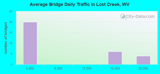
- 175,868Total average daily traffic
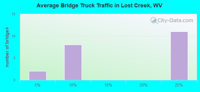
- 33,215Total average daily truck traffic
- National Bridge Inventory (NBI) Registered Bridges for Lost Creek
- No street view available for this location
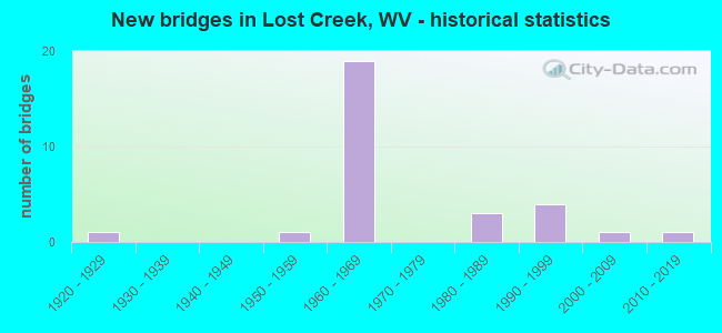
- New bridges - historical statistics
- 11920-1929
- 11950-1959
- 191960-1969
- 31980-1989
- 41990-1999
- 12000-2009
- 12010-2019
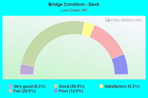
- Bridge Condition - Deck
- 6.3%Very good
- 50.0%Good
- 6.3%Satisfactory
- 25.0%Fair
- 12.5%Poor
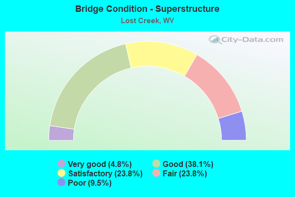
- Bridge Condition - Superstructure
- 4.8%Very good
- 38.1%Good
- 23.8%Satisfactory
- 23.8%Fair
- 9.5%Poor
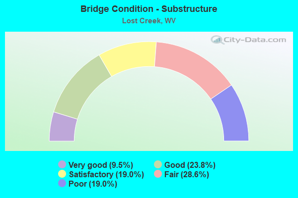
- Bridge Condition - Substructure
- 9.5%Very good
- 23.8%Good
- 19.0%Satisfactory
- 28.6%Fair
- 19.0%Poor

- Bridge Condition - Channel
- 20.0%Very good
- 40.0%Good
- 13.3%Satisfactory
- 13.3%Fair
- 13.3%Poor
Find on map >> Show street view
Structure Number: 17A146, Location: 0.22 MI SOUTH WV RT 270 (Lat: 39.159000, Lng: -80.355100), Route carried "on" structure: County highway 2500, Year Built: 1987, Status: Open, Structure Length: 2.64m (8.66ft), Average Daily Traffic: 850 (year 2018), Truck Traffic: 7%, Average Future Daily Traffic: 1,125 (year 2038), Design Load: HS 20, Features Intersected: LOST CREEK, Facility Carried by Structure: HARRISON CO RT 25
Minimum Vertical Clearance: 30+ m (98+ ft), Kilometerpoint: 4.989, Lanes on structure: 2, Owner: State Highway Agency, Approaching Roadway Width: 6.7m (22.0ft), Skew: 1 degrees, Material/Design: Prestressed concrete, Design/Construction: Box Beam or Girders - Multiple, Number Of Spans In Main Unit: 2, Length of Maximum Span: 12.2m (40.0ft), Curb-To-Curb Width: 8.8m (28.9ft), Out-to-Out Width: 9.2m (30.2ft)
Condition: Superstructure: Good, Substructure: Satisfactory, Channel: Satisfactory, Operating Rating: 68.0 metric tons, Method Used To Determine Operating Rating: Load Factor (LF), Inventory Rating: 40.8 metric tons, Method Used To Determine Inventory Rating: Load Factor (LF), Structural Evaluation: Equal to present minimum criteria, Deck Geometry: Somewhat better than minimum adequacy, Waterway Adequacy: Equal to present minimum criteria, Approach Roadway Alignment: Better than present minimum criteria, Designated Inspection Frequency: Every 48 months, Inspection Date: December 2019, Deck Structure Type: Other, Wearing Surface/Protective System: Wearing Surface: Bituminous, Deck Protection: Epoxy Coated Reinforcing
Find on map >> Show street view
Structure Number: 17A155, Location: 0.12 MI WEST WV RT 270 (Lat: 39.173050, Lng: -80.373250), Route carried "on" structure: County highway 2701, Year Built: 1954, Status: Open, Structure Length: 0.98m (3.22ft), Average Daily Traffic: 50 (year 2018), Average Future Daily Traffic: 65 (year 2038), Design Load: H 20, Features Intersected: LOST CREEK, Facility Carried by Structure: HARRISON CR 27/1
Minimum Vertical Clearance: 30+ m (98+ ft), Kilometerpoint: 0.193, Lanes on structure: 1, Owner: State Highway Agency, Approaching Roadway Width: 3.4m (11.2ft), Material/Design: Steel, Design/Construction: Girder and Floorbeam System, Number Of Spans In Main Unit: 1, Length of Maximum Span: 9.3m (30.5ft), Curb-To-Curb Width: 4.2m (13.8ft), Out-to-Out Width: 4.3m (14.1ft)
Condition: Deck: Fair, Superstructure: Fair, Substructure: Fair, Channel: Satisfactory, Operating Rating: 68.9 metric tons, Method Used To Determine Operating Rating: Load Factor (LF), Inventory Rating: 41.7 metric tons, Method Used To Determine Inventory Rating: Load Factor (LF), Structural Evaluation: Somewhat better than minimum adequacy, Deck Geometry: Somewhat better than minimum adequacy, Waterway Adequacy: Somewhat better than minimum adequacy, Approach Roadway Alignment: Equal to present minimum criteria, Length Of Structure Improvement: 1.55m (5.09ft), Designated Inspection Frequency: Every 24 months, Critical Feature Inspection Frequency: Every 24 months, Inspection Date: September 2020, Critical Feature Inspection Date: September 2020, Bridge Improvement Cost: $159,000, Roadway Improvement Cost: $108,000, Total Project Cost: $351,000 ( Estimate for 2020), Deck Structure Type: Wood or Timber
Find on map >> Show street view
Structure Number: 17A157, Location: 0.11 MI SOUTH WV RT 270 (Lat: 39.166519, Lng: -80.368400), Route carried "on" structure: County highway 2702, Year Built: 1994, Status: Open, Structure Length: 1.37m (4.49ft), Average Daily Traffic: 50 (year 2019), Average Future Daily Traffic: 65 (year 2039), Design Load: HS 25 or greater, Features Intersected: LOST CREEK, Facility Carried by Structure: HARR CO RT 27/2
Minimum Vertical Clearance: 30+ m (98+ ft), Kilometerpoint: 3.460, Lanes on structure: 2, Owner: State Highway Agency, Approaching Roadway Width: 5.5m (18.0ft), Material/Design: Wood or Timber, Design/Construction: Stringer/Multi-beam, Number Of Spans In Main Unit: 1, Length of Maximum Span: 12.5m (41.0ft), Curb-To-Curb Width: 5.9m (19.4ft), Out-to-Out Width: 6.5m (21.3ft)
Condition: Deck: Good, Superstructure: Good, Substructure: Fair, Channel: Fair, Operating Rating: 49.0 metric tons, Method Used To Determine Operating Rating: Allowable Stress (AS), Inventory Rating: 34.5 metric tons, Method Used To Determine Inventory Rating: Allowable Stress (AS), Structural Evaluation: Somewhat better than minimum adequacy, Deck Geometry: Meets minimum limits, Waterway Adequacy: Meets minimum limits, Approach Roadway Alignment: Equal to present minimum criteria, Designated Inspection Frequency: Every 24 months, Inspection Date: January 2021, Deck Structure Type: Wood or Timber, Wearing Surface/Protective System: Wearing Surface: Bituminous, Membrane: Preformed Fabric
Find on map >> Show street view
Structure Number: 17A182, Location: 0.03 MI SOUTH CO RT 48 (Lat: 39.133950, Lng: -80.332319), Route carried "on" structure: County highway 4802, Year Built: 1980, Status: Open, Structure Length: 0.92m (3.02ft), Average Daily Traffic: 100 (year 2018), Average Future Daily Traffic: 130 (year 2038), Design Load: H 20, Features Intersected: LOST CREEK, Facility Carried by Structure: HARRISON CR 48/2
Minimum Vertical Clearance: 30+ m (98+ ft), Kilometerpoint: 3.573, Lanes on structure: 1, Owner: State Highway Agency, Approaching Roadway Width: 4.0m (13.1ft), Material/Design: Steel, Design/Construction: Stringer/Multi-beam, Number Of Spans In Main Unit: 1, Length of Maximum Span: 8.1m (26.6ft), Curb-To-Curb Width: 4.3m (14.1ft), Out-to-Out Width: 4.3m (14.1ft)
Condition: Deck: Good, Superstructure: Good, Substructure: Good, Channel: Good, Operating Rating: 65.3 metric tons, Method Used To Determine Operating Rating: Load Factor (LF), Inventory Rating: 39.0 metric tons, Method Used To Determine Inventory Rating: Load Factor (LF), Structural Evaluation: Better than present minimum criteria, Deck Geometry: Equal to present minimum criteria, Waterway Adequacy: Better than present minimum criteria, Approach Roadway Alignment: Equal to present minimum criteria, Designated Inspection Frequency: Every 24 months, Inspection Date: August 2020, Deck Structure Type: Wood or Timber
Find on map >> Show street view
Structure Number: 17A237, Location: 2.19 MI SOUTH WV RT 270 (Lat: 39.136481, Lng: -80.374781), Route carried "on" structure: Interstate 7900, Year Built: 1965, Status: Open, Structure Length: 3.64m (11.94ft), Average Daily Traffic: 14,950 (year 2018), Truck Traffic: 20%, Average Future Daily Traffic: 21,225 (year 2038), Design Load: HS 20, Features Intersected: Har. Co. 25/6, Facility Carried by Structure: INTERSTATE 79 NB
Minimum Vertical Clearance: 30+ m (98+ ft), Kilometerpoint: 173.085, Lanes on structure: 2, Lanes under structure: 2, Base Highway Network: Yes, Owner: State Highway Agency, Approaching Roadway Width: 11.3m (37.1ft), Material/Design: Steel continuous, Design/Construction: Stringer/Multi-beam, Number Of Spans In Main Unit: 1, Number Of Approach Spans: 2, Length of Maximum Span: 14.4m (47.2ft), Curb-To-Curb Width: 11.2m (36.7ft), Out-to-Out Width: 12.3m (40.4ft)
Condition: Deck: Fair, Superstructure: Poor, Substructure: Poor, Operating Rating: 58.0 metric tons, Method Used To Determine Operating Rating: Load Factor (LF), Inventory Rating: 35.4 metric tons, Method Used To Determine Inventory Rating: Load Factor (LF), Structural Evaluation: Meets minimum limits, Deck Geometry: Somewhat better than minimum adequacy, Underclear: Somewhat better than minimum adequacy, Approach Roadway Alignment: Equal to present desirable criteria, Length Of Structure Improvement: 3.63m (11.91ft), Designated Inspection Frequency: Every 24 months, Other Special Inspection Frequency: Every 12 months, Inspection Date: March 2020, Other Special Inspection Date: March 2021, Bridge Improvement Cost: $437,000, Roadway Improvement Cost: $117,000, Total Project Cost: $688,000 ( Estimate for 2020), Deck Structure Type: Concrete Cast-file-Place, Wearing Surface/Protective System: Wearing Surface: Bituminous
Find on map >> Show street view
Structure Number: 17A238, Location: 2.19 MI SOUTH WV RT 270 (Lat: 39.136639, Lng: -80.375019), Route carried "on" structure: Interstate 7900, Year Built: 1965, Status: Open, Structure Length: 4.24m (13.91ft), Average Daily Traffic: 14,950 (year 2018), Truck Traffic: 20%, Average Future Daily Traffic: 21,225 (year 2038), Design Load: HS 20, Features Intersected: Har. Co. 25/6, Facility Carried by Structure: INTERSTATE 79 SB
Minimum Vertical Clearance: 30+ m (98+ ft), Kilometerpoint: 173.085, Lanes on structure: 2, Lanes under structure: 2, Base Highway Network: Yes, Owner: State Highway Agency, Approaching Roadway Width: 11.3m (37.1ft), Material/Design: Steel continuous, Design/Construction: Stringer/Multi-beam, Number Of Spans In Main Unit: 1, Number Of Approach Spans: 2, Length of Maximum Span: 14.4m (47.2ft), Curb-To-Curb Width: 11.1m (36.4ft), Out-to-Out Width: 12.3m (40.4ft)
Condition: Deck: Fair, Superstructure: Fair, Substructure: Poor, Operating Rating: 66.2 metric tons, Method Used To Determine Operating Rating: Load Factor (LF), Inventory Rating: 39.9 metric tons, Method Used To Determine Inventory Rating: Load Factor (LF), Structural Evaluation: Meets minimum limits, Deck Geometry: Somewhat better than minimum adequacy, Underclear: Equal to present minimum criteria, Approach Roadway Alignment: Equal to present desirable criteria, Length Of Structure Improvement: 4.24m (13.91ft), Designated Inspection Frequency: Every 24 months, Inspection Date: March 2020, Bridge Improvement Cost: $408,000, Roadway Improvement Cost: $121,000, Total Project Cost: $624,000 ( Estimate for 2020), Deck Structure Type: Concrete Cast-file-Place, Wearing Surface/Protective System: Wearing Surface: Bituminous
Find on map >> Show street view
Structure Number: 17A239, Location: 0.24 MI SOUTH WV RT 270 (Lat: 39.159339, Lng: -80.355719), Route carried "on" structure: Interstate 7900, Year Built: 1965, Year Reconstructed: 1999, Status: Open, Structure Length: 6.84m (22.44ft), Average Daily Traffic: 14,950 (year 2018), Truck Traffic: 20%, Average Future Daily Traffic: 21,225 (year 2038), Design Load: HS 25 or greater, Features Intersected: Lost Creek & Access Road, Facility Carried by Structure: INTERSTATE 79 NB
Minimum Vertical Clearance: 30+ m (98+ ft), Kilometerpoint: 176.239, Lanes on structure: 2, Lanes under structure: 2, Base Highway Network: Yes, Owner: State Highway Agency, Approaching Roadway Width: 11.6m (38.1ft), Material/Design: Steel continuous, Design/Construction: Stringer/Multi-beam, Number Of Spans In Main Unit: 2, Number Of Approach Spans: 2, Length of Maximum Span: 18.6m (61.0ft), Curb-To-Curb Width: 9.6m (31.5ft), Out-to-Out Width: 10.7m (35.1ft)
Condition: Deck: Good, Superstructure: Good, Substructure: Fair, Channel: Very good, Operating Rating: 88.9 metric tons, Method Used To Determine Operating Rating: Load Factor (LF), Inventory Rating: 88.9 metric tons, Method Used To Determine Inventory Rating: Load Factor (LF), Structural Evaluation: Somewhat better than minimum adequacy, Deck Geometry: Meets minimum limits, Underclear: Superior to present desirable criteria, Waterway Adequacy: Superior to present desirable criteria, Approach Roadway Alignment: Equal to present desirable criteria, Designated Inspection Frequency: Every 24 months, Inspection Date: May 2020, Deck Structure Type: Concrete Cast-file-Place, Wearing Surface/Protective System: Wearing Surface: Integral Concrete, Deck Protection: Epoxy Coated Reinforcing
Find on map >> Show street view
Structure Number: 17A24, Location: 0.24 MI SOUTH WV RT 270 (Lat: 39.159281, Lng: -80.355500), Route carried "on" structure: Interstate 7900, Year Built: 1965, Year Reconstructed: 1999, Status: Open, Structure Length: 6.84m (22.44ft), Average Daily Traffic: 14,950 (year 2018), Truck Traffic: 20%, Average Future Daily Traffic: 21,225 (year 2038), Design Load: HS 25 or greater, Features Intersected: Lost Creek & Access Road, Facility Carried by Structure: INTERSTATE 79 SB
Minimum Vertical Clearance: 30+ m (98+ ft), Kilometerpoint: 176.239, Lanes on structure: 3, Lanes under structure: 2, Base Highway Network: Yes, Owner: State Highway Agency, Approaching Roadway Width: 14.9m (48.9ft), Material/Design: Steel continuous, Design/Construction: Stringer/Multi-beam, Number Of Spans In Main Unit: 2, Number Of Approach Spans: 2, Length of Maximum Span: 18.6m (61.0ft), Curb-To-Curb Width: 13.3m (43.6ft), Out-to-Out Width: 14.3m (46.9ft)
Condition: Deck: Good, Superstructure: Good, Substructure: Satisfactory, Channel: Very good, Operating Rating: 88.9 metric tons, Method Used To Determine Operating Rating: Load Factor (LF), Inventory Rating: 88.9 metric tons, Method Used To Determine Inventory Rating: Load Factor (LF), Structural Evaluation: Equal to present minimum criteria, Deck Geometry: Meets minimum limits, Underclear: Superior to present desirable criteria, Waterway Adequacy: Superior to present desirable criteria, Approach Roadway Alignment: Equal to present desirable criteria, Designated Inspection Frequency: Every 24 months, Inspection Date: May 2020, Deck Structure Type: Concrete Cast-file-Place, Wearing Surface/Protective System: Wearing Surface: Integral Concrete, Deck Protection: Epoxy Coated Reinforcing
Find on map >> Show street view
Structure Number: 17A241, Location: 5.61 MI SOUTH WV RT 20 (Lat: 39.161919, Lng: -80.353539), Route carried "on" structure: Interstate 7900, Year Built: 1965, Status: Open, Structure Length: 3.66m (12.01ft), Average Daily Traffic: 14,950 (year 2018), Truck Traffic: 20%, Average Future Daily Traffic: 21,225 (year 2038), Design Load: HS 20, Features Intersected: WV 270, Facility Carried by Structure: I-79 NB
Minimum Vertical Clearance: 30+ m (98+ ft), Kilometerpoint: 176.609, Lanes on structure: 2, Lanes under structure: 2, Base Highway Network: Yes, Owner: State Highway Agency, Approaching Roadway Width: 11.3m (37.1ft), Material/Design: Steel continuous, Design/Construction: Stringer/Multi-beam, Number Of Spans In Main Unit: 1, Number Of Approach Spans: 2, Length of Maximum Span: 13.7m (44.9ft), Curb-To-Curb Width: 11.2m (36.7ft), Out-to-Out Width: 12.3m (40.4ft)
Condition: Deck: Fair, Superstructure: Fair, Substructure: Poor, Operating Rating: 72.6 metric tons, Method Used To Determine Operating Rating: Load Factor (LF), Inventory Rating: 43.5 metric tons, Method Used To Determine Inventory Rating: Load Factor (LF), Structural Evaluation: Meets minimum limits, Deck Geometry: Somewhat better than minimum adequacy, Underclear: Somewhat better than minimum adequacy, Approach Roadway Alignment: Equal to present desirable criteria, Length Of Structure Improvement: 3.66m (12.01ft), Designated Inspection Frequency: Every 24 months, Inspection Date: May 2020, Bridge Improvement Cost: $484,000, Roadway Improvement Cost: $224,000, Total Project Cost: $852,000 ( Estimate for 2020), Deck Structure Type: Concrete Cast-file-Place, Wearing Surface/Protective System: Wearing Surface: Latex Concrete
Find on map >> Show street view
Structure Number: 17A242, Location: 5.61 MI SOUTH WV RT 20 (Lat: 39.161819, Lng: -80.353381), Route carried "on" structure: Interstate 7900, Year Built: 1965, Status: Open, Structure Length: 3.66m (12.01ft), Average Daily Traffic: 14,950 (year 2018), Truck Traffic: 20%, Average Future Daily Traffic: 21,225 (year 2038), Design Load: HS 20, Features Intersected: WV 270, Facility Carried by Structure: I-79 SB
Minimum Vertical Clearance: 30+ m (98+ ft), Kilometerpoint: 176.609, Lanes on structure: 2, Lanes under structure: 2, Base Highway Network: Yes, Owner: State Highway Agency, Approaching Roadway Width: 11.3m (37.1ft), Material/Design: Steel continuous, Design/Construction: Stringer/Multi-beam, Number Of Spans In Main Unit: 1, Number Of Approach Spans: 2, Length of Maximum Span: 13.7m (44.9ft), Curb-To-Curb Width: 11.2m (36.7ft), Out-to-Out Width: 12.3m (40.4ft)
Condition: Deck: Poor, Superstructure: Satisfactory, Substructure: Poor, Operating Rating: 75.3 metric tons, Method Used To Determine Operating Rating: Load Factor (LF), Inventory Rating: 45.4 metric tons, Method Used To Determine Inventory Rating: Load Factor (LF), Structural Evaluation: Meets minimum limits, Deck Geometry: Somewhat better than minimum adequacy, Underclear: Somewhat better than minimum adequacy, Approach Roadway Alignment: Equal to present desirable criteria, Length Of Structure Improvement: 3.66m (12.01ft), Designated Inspection Frequency: Every 24 months, Inspection Date: May 2020, Bridge Improvement Cost: $398,000, Roadway Improvement Cost: $128,000, Total Project Cost: $591,000 ( Estimate for 2020), Deck Structure Type: Concrete Cast-file-Place, Wearing Surface/Protective System: Wearing Surface: Latex Concrete
Find on map >> Show street view
Structure Number: 17A243, Location: 0.91 MI NORTH WV RT 270 (Lat: 39.172550, Lng: -80.343939), Route carried "on" structure: Interstate 7900, Year Built: 1967, Year Reconstructed: 1999, Status: Open, Structure Length: 4.90m (16.08ft), Average Daily Traffic: 17,600 (year 2018), Truck Traffic: 20%, Average Future Daily Traffic: 25,000 (year 2038), Design Load: HS 25 or greater, Features Intersected: I-79 OFF RAMP, Facility Carried by Structure: INTERSTATE 79 NB
Minimum Vertical Clearance: 30+ m (98+ ft), Kilometerpoint: 178.074, Lanes on structure: 2, Lanes under structure: 1, Base Highway Network: Yes, Owner: State Highway Agency, Approaching Roadway Width: 11.3m (37.1ft), Material/Design: Steel continuous, Design/Construction: Stringer/Multi-beam, Number Of Spans In Main Unit: 1, Number Of Approach Spans: 2, Length of Maximum Span: 17.5m (57.4ft), Curb-To-Curb Width: 11.9m (39.0ft), Out-to-Out Width: 13.0m (42.7ft)
Condition: Deck: Good, Superstructure: Good, Substructure: Good, Operating Rating: 74.4 metric tons, Method Used To Determine Operating Rating: Load Factor (LF), Inventory Rating: 44.4 metric tons, Method Used To Determine Inventory Rating: Load Factor (LF), Structural Evaluation: Better than present minimum criteria, Deck Geometry: Equal to present minimum criteria, Underclear: Superior to present desirable criteria, Approach Roadway Alignment: Equal to present desirable criteria, Designated Inspection Frequency: Every 24 months, Inspection Date: April 2020, Deck Structure Type: Concrete Cast-file-Place, Wearing Surface/Protective System: Wearing Surface: Integral Concrete, Deck Protection: Epoxy Coated Reinforcing
Find on map >> Show street view
Structure Number: 17A244, Location: 0.91 MI NORTH WV RT 270 (Lat: 39.172589, Lng: -80.344231), Route carried "on" structure: Interstate 7900, Year Built: 1967, Year Reconstructed: 1998, Status: Open, Structure Length: 3.96m (12.99ft), Average Daily Traffic: 17,600 (year 2018), Truck Traffic: 20%, Average Future Daily Traffic: 25,000 (year 2038), Design Load: HS 25 or greater, Features Intersected: I-79 SB OFF RAMP, Facility Carried by Structure: INTERSTATE 79 SB
Minimum Vertical Clearance: 30+ m (98+ ft), Kilometerpoint: 178.074, Lanes on structure: 2, Lanes under structure: 1, Base Highway Network: Yes, Owner: State Highway Agency, Approaching Roadway Width: 11.3m (37.1ft), Material/Design: Steel, Design/Construction: Stringer/Multi-beam, Number Of Spans In Main Unit: 1, Number Of Approach Spans: 2, Length of Maximum Span: 17.8m (58.4ft), Curb-To-Curb Width: 11.9m (39.0ft), Out-to-Out Width: 13.0m (42.7ft)
Condition: Deck: Good, Superstructure: Fair, Substructure: Fair, Operating Rating: 88.9 metric tons, Method Used To Determine Operating Rating: Load Factor (LF), Inventory Rating: 57.1 metric tons, Method Used To Determine Inventory Rating: Load Factor (LF), Structural Evaluation: Somewhat better than minimum adequacy, Deck Geometry: Equal to present minimum criteria, Underclear: High priority of corrective action, Approach Roadway Alignment: Equal to present desirable criteria, Length Of Structure Improvement: 3.96m (12.99ft), Designated Inspection Frequency: Every 24 months, Inspection Date: April 2020, Bridge Improvement Cost: $471,000, Roadway Improvement Cost: $116,000, Total Project Cost: $647,000 ( Estimate for 2020), Deck Structure Type: Concrete Cast-file-Place, Wearing Surface/Protective System: Wearing Surface: Integral Concrete, Deck Protection: Epoxy Coated Reinforcing
Find on map >> Show street view
Structure Number: 17A246, Location: 2.17 MI NORTH WV RT 270 (Lat: 39.188150, Lng: -80.333131), Route carried "on" structure: Interstate 7900, Year Built: 1966, Year Reconstructed: 1999, Status: Open, Structure Length: 7.99m (26.21ft), Average Daily Traffic: 17,600 (year 2018), Truck Traffic: 20%, Average Future Daily Traffic: 25,000 (year 2038), Design Load: HS 25 or greater, Features Intersected: Browns Creek & HRR CO 25, Facility Carried by Structure: INTERSTATE 79 NB
Minimum Vertical Clearance: 30+ m (98+ ft), Kilometerpoint: 180.102, Lanes on structure: 2, Lanes under structure: 2, Base Highway Network: Yes, Owner: State Highway Agency, Approaching Roadway Width: 11.6m (38.1ft), Skew: 2 degrees, Material/Design: Steel continuous, Design/Construction: Stringer/Multi-beam, Number Of Spans In Main Unit: 2, Number Of Approach Spans: 2, Length of Maximum Span: 22.9m (75.1ft), Curb-To-Curb Width: 10.1m (33.1ft), Out-to-Out Width: 11.2m (36.7ft)
Condition: Deck: Good, Superstructure: Satisfactory, Substructure: Fair, Channel: Good, Operating Rating: 88.9 metric tons, Method Used To Determine Operating Rating: Load Factor (LF), Inventory Rating: 82.5 metric tons, Method Used To Determine Inventory Rating: Load Factor (LF), Structural Evaluation: Somewhat better than minimum adequacy, Deck Geometry: Meets minimum limits, Underclear: Somewhat better than minimum adequacy, Waterway Adequacy: Superior to present desirable criteria, Approach Roadway Alignment: Equal to present desirable criteria, Designated Inspection Frequency: Every 24 months, Inspection Date: April 2020, Deck Structure Type: Concrete Cast-file-Place, Wearing Surface/Protective System: Wearing Surface: Integral Concrete, Deck Protection: Epoxy Coated Reinforcing
Find on map >> Show street view
Structure Number: 17A247, Location: 2.17 MI NORTH WV RT 270 (Lat: 39.188031, Lng: -80.332969), Route carried "on" structure: Interstate 7900, Year Built: 1966, Year Reconstructed: 1998, Status: Open, Structure Length: 7.99m (26.21ft), Average Daily Traffic: 17,600 (year 2018), Truck Traffic: 20%, Average Future Daily Traffic: 25,000 (year 2038), Design Load: HS 25 or greater, Features Intersected: Browns Creek & HRR CO 25, Facility Carried by Structure: INTERSTATE 79 SB
Minimum Vertical Clearance: 30+ m (98+ ft), Kilometerpoint: 180.102, Lanes on structure: 2, Lanes under structure: 2, Base Highway Network: Yes, Owner: State Highway Agency, Approaching Roadway Width: 11.6m (38.1ft), Skew: 2 degrees, Material/Design: Steel continuous, Design/Construction: Stringer/Multi-beam, Number Of Spans In Main Unit: 2, Number Of Approach Spans: 2, Length of Maximum Span: 22.9m (75.1ft), Curb-To-Curb Width: 10.1m (33.1ft), Out-to-Out Width: 11.2m (36.7ft)
Condition: Deck: Poor, Superstructure: Fair, Substructure: Fair, Channel: Good, Operating Rating: 88.9 metric tons, Method Used To Determine Operating Rating: Load Factor (LF), Inventory Rating: 82.5 metric tons, Method Used To Determine Inventory Rating: Load Factor (LF), Structural Evaluation: Somewhat better than minimum adequacy, Deck Geometry: Meets minimum limits, Underclear: Better than present minimum criteria, Waterway Adequacy: Superior to present desirable criteria, Approach Roadway Alignment: Equal to present desirable criteria, Designated Inspection Frequency: Every 24 months, Inspection Date: April 2020, Deck Structure Type: Concrete Cast-file-Place, Wearing Surface/Protective System: Wearing Surface: Integral Concrete, Deck Protection: Epoxy Coated Reinforcing
Find on map >> Show street view
Structure Number: 17A269, Location: 0.11 MI SOUTH WV RT 270 (Lat: 39.160339, Lng: -80.353581), Route carried "on" structure: County highway 2500, Year Built: 1982, Status: Open, Structure Length: 0.84m (2.76ft), Average Daily Traffic: 850 (year 2018), Truck Traffic: 7%, Average Future Daily Traffic: 1,125 (year 2038), Design Load: HS 20, Features Intersected: GEE LICK, Facility Carried by Structure: HARR CO RT 25
Minimum Vertical Clearance: 30+ m (98+ ft), Kilometerpoint: 5.166, Lanes on structure: 2, Owner: State Highway Agency, Approaching Roadway Width: 6.7m (22.0ft), Skew: 2 degrees, Material/Design: Prestressed concrete, Design/Construction: Box Beam or Girders - Multiple, Number Of Spans In Main Unit: 1, Length of Maximum Span: 7.9m (25.9ft), Curb-To-Curb Width: 6.9m (22.6ft), Out-to-Out Width: 7.4m (24.3ft)
Condition: Superstructure: Satisfactory, Substructure: Good, Channel: Poor, Operating Rating: 88.9 metric tons, Method Used To Determine Operating Rating: Load Factor (LF), Inventory Rating: 59.0 metric tons, Method Used To Determine Inventory Rating: Load Factor (LF), Structural Evaluation: Equal to present minimum criteria, Deck Geometry: Meets minimum limits, Waterway Adequacy: Meets minimum limits, Approach Roadway Alignment: Equal to present desirable criteria, Length Of Structure Improvement: 0.85m (2.79ft), Designated Inspection Frequency: Every 24 months, Inspection Date: Febuary 2020, Bridge Improvement Cost: $182,000, Roadway Improvement Cost: $104,000, Total Project Cost: $388,000 ( Estimate for 2020), Deck Structure Type: Other, Wearing Surface/Protective System: Wearing Surface: Bituminous, Deck Protection: Epoxy Coated Reinforcing
Find on map >> Show street view
Structure Number: 17A306, Location: 0.04 MI SOUTH WV RT 270 (Lat: 39.182481, Lng: -80.377500), Route carried "on" structure: County highway 27001, Year Built: 1999, Status: Open, Structure Length: 1.87m (6.14ft), Average Daily Traffic: 100 (year 2019), Average Future Daily Traffic: 130 (year 2039), Design Load: HS 25 or greater, Features Intersected: LOST CREEK, Facility Carried by Structure: HARRISON CO 270/1
Minimum Vertical Clearance: 30+ m (98+ ft), Kilometerpoint: 0.064, Lanes on structure: 2, Owner: State Highway Agency, Approaching Roadway Width: 6.4m (21.0ft), Material/Design: Prestressed concrete, Design/Construction: Box Beam or Girders - Multiple, Number Of Spans In Main Unit: 1, Length of Maximum Span: 17.5m (57.4ft), Curb-To-Curb Width: 6.2m (20.3ft), Out-to-Out Width: 6.6m (21.7ft)
Condition: Superstructure: Good, Substructure: Very good, Channel: Very good, Operating Rating: 72.6 metric tons, Method Used To Determine Operating Rating: Load Factor (LF), Inventory Rating: 43.5 metric tons, Method Used To Determine Inventory Rating: Load Factor (LF), Structural Evaluation: Better than present minimum criteria, Deck Geometry: Somewhat better than minimum adequacy, Waterway Adequacy: Equal to present minimum criteria, Approach Roadway Alignment: Equal to present desirable criteria, Designated Inspection Frequency: Every 48 months, Inspection Date: Febuary 2021, Deck Structure Type: Other, Wearing Surface/Protective System: Deck Protection: Epoxy Coated Reinforcing
Find on map >> Show street view
Structure Number: 17A313, Location: 0.01 MI NORTH CO RT 20/17 (Lat: 39.172000, Lng: -80.280900), Route carried "on" structure: County highway 2019, Year Built: 2001, Status: Open, Structure Length: 3.71m (12.17ft), Average Daily Traffic: 450 (year 2019), Truck Traffic: 8%, Average Future Daily Traffic: 615 (year 2041), Design Load: HS 25 or greater, Features Intersected: ELK CREEK, Facility Carried by Structure: HARRISON CO 20/19
Minimum Vertical Clearance: 30+ m (98+ ft), Kilometerpoint: 4.989, Lanes on structure: 2, Owner: State Highway Agency, Approaching Roadway Width: 5.8m (19.0ft), Skew: 1 degrees, Material/Design: Prestressed concrete, Design/Construction: Box Beam or Girders - Multiple, Number Of Spans In Main Unit: 3, Length of Maximum Span: 11.7m (38.4ft), Curb-To-Curb Width: 6.2m (20.3ft), Out-to-Out Width: 6.5m (21.3ft)
Condition: Superstructure: Good, Substructure: Satisfactory, Channel: Poor, Operating Rating: 75.3 metric tons, Method Used To Determine Operating Rating: Load Factor (LF), Inventory Rating: 45.4 metric tons, Method Used To Determine Inventory Rating: Load Factor (LF), Structural Evaluation: Equal to present minimum criteria, Deck Geometry: High priority of corrective action, Waterway Adequacy: Better than present minimum criteria, Approach Roadway Alignment: Equal to present minimum criteria, Designated Inspection Frequency: Every 24 months, Inspection Date: November 2021, Deck Structure Type: Other, Wearing Surface/Protective System: Wearing Surface: Bituminous, Deck Protection: Epoxy Coated Reinforcing
Find on map >> Show street view
Structure Number: 17A358, Location: 0.63 mi W of Har Rt 44/6 (Lat: 39.182200, Lng: -80.291100), Route carried "on" structure: County highway 443, Year Built: 2018, Status: Open, Structure Length: 1.29m (4.23ft), Average Daily Traffic: 250 (year 2018), Truck Traffic: 7%, Average Future Daily Traffic: 325 (year 2038), Design Load: HL 93, Features Intersected: Hastings Run, Facility Carried by Structure: Har Co Rt 44/3
Minimum Vertical Clearance: 30+ m (98+ ft), Kilometerpoint: 3.476, Lanes on structure: 2, Owner: State Highway Agency, Approaching Roadway Width: 4.9m (16.1ft), Material/Design: Steel, Design/Construction: Stringer/Multi-beam, Number Of Spans In Main Unit: 1, Length of Maximum Span: 11.7m (38.4ft), Curb-To-Curb Width: 4.9m (16.1ft), Out-to-Out Width: 4.9m (16.1ft)
Condition: Deck: Very good, Superstructure: Very good, Substructure: Very good, Channel: Good, Operating Rating: 49.0 metric tons, Method Used To Determine Operating Rating: Load and Resistance Factor (LRFR), Inventory Rating: 38.1 metric tons, Method Used To Determine Inventory Rating: Load and Resistance Factor (LRFR), Structural Evaluation: Equal to present desirable criteria, Deck Geometry: High priority of replacement, Waterway Adequacy: Equal to present minimum criteria, Approach Roadway Alignment: Equal to present minimum criteria, Designated Inspection Frequency: Every 24 months, Inspection Date: December 2020, Deck Structure Type: Wood or Timber
Find on map >> Show street view
Structure Number: 17A914, Location: 0.02 MI SOUTH CO RT 48 (Lat: 39.158889, Lng: -80.349461), Route carried "on" structure: City street N0905, Year Built: 1990, Status: Open, Structure Length: 1.05m (3.44ft), Average Daily Traffic: 100 (year 2020), Average Future Daily Traffic: 150 (year 2030), Design Load: HS 20, Features Intersected: LOST CREEK, Facility Carried by Structure: VIRGINIA AVENUE
Minimum Vertical Clearance: 30+ m (98+ ft), Kilometerpoint: 0.016, Lanes on structure: 2, Owner: City or Municipal Highway Agency, Approaching Roadway Width: 5.2m (17.1ft), Material/Design: Concrete, Design/Construction: Frame, Number Of Spans In Main Unit: 1, Length of Maximum Span: 9.8m (32.2ft), Curb or Sidewalk Widths: Left: 0.0m, Right: 1.0m (3.3ft), Curb-To-Curb Width: 6.9m (22.6ft), Out-to-Out Width: 8.6m (28.2ft)
Condition: Deck: Satisfactory, Superstructure: Satisfactory, Substructure: Satisfactory, Channel: Good, Operating Rating: 71.7 metric tons, Method Used To Determine Operating Rating: Field evaluation and documented engineering judgment, Inventory Rating: 32.7 metric tons, Method Used To Determine Inventory Rating: Field evaluation and documented engineering judgment, Structural Evaluation: Equal to present minimum criteria, Deck Geometry: Somewhat better than minimum adequacy, Waterway Adequacy: Somewhat better than minimum adequacy, Approach Roadway Alignment: Somewhat better than minimum adequacy, Designated Inspection Frequency: Every 24 months, Inspection Date: May 2020, Deck Structure Type: Concrete Precast Panels, Wearing Surface/Protective System: Wearing Surface: Bituminous
Find on map >> Show street view
Structure Number: 17A918, Location: 0.05 MI SOUTH CO RT 48 (Lat: 39.149511, Lng: -80.344350), Route carried "on" structure: City street N0905, Year Built: 1920, Status: Posted for load, Structure Length: 0.98m (3.22ft), Average Daily Traffic: 10 (year 2018), Average Future Daily Traffic: 13 (year 2038), Features Intersected: LOST CREEK, Facility Carried by Structure: HRR CO RT 48/16
Minimum Vertical Clearance: 30+ m (98+ ft), Kilometerpoint: 0.032, Lanes on structure: 1, Owner: City or Municipal Highway Agency, Approaching Roadway Width: 2.7m (8.9ft), Skew: 2 degrees, Material/Design: Concrete, Design/Construction: Slab, Number Of Spans In Main Unit: 1, Length of Maximum Span: 9.1m (29.9ft), Curb or Sidewalk Widths: Left: 0.1m (0.3ft), Right: 0.1m (0.3ft), Curb-To-Curb Width: 2.8m (9.2ft), Out-to-Out Width: 3.6m (11.8ft)
Condition: Superstructure: Poor, Substructure: Good, Channel: Fair, Operating Rating: 39.9 metric tons, Method Used To Determine Operating Rating: Field evaluation and documented engineering judgment, Inventory Rating: 18.1 metric tons, Method Used To Determine Inventory Rating: Field evaluation and documented engineering judgment, Structural Evaluation: Meets minimum limits, Deck Geometry: High priority of replacement, Waterway Adequacy: Better than present minimum criteria, Approach Roadway Alignment: Equal to present desirable criteria, Length Of Structure Improvement: 1.52m (4.99ft), Designated Inspection Frequency: Every 24 months, Inspection Date: Febuary 2020, Bridge Improvement Cost: $234,000, Roadway Improvement Cost: $151,000, Total Project Cost: $402,000 ( Estimate for 2020), Deck Structure Type: Concrete Cast-file-Place, Wearing Surface/Protective System: Wearing Surface: Bituminous
Find on map >> Show street view
Structure Number: 17A921, Location: 0.03 MI EAST CO RT 25 (Lat: 39.166011, Lng: -80.346639), Route carried "on" structure: City street N0905, Year Built: 1996, Status: Open, Structure Length: 1.27m (4.17ft), Average Daily Traffic: 50 (year 2019), Average Future Daily Traffic: 65 (year 2041), Features Intersected: GEE LICK, Facility Carried by Structure: BROADWAY AVENUE
Minimum Vertical Clearance: 30+ m (98+ ft), Kilometerpoint: 0.048, Lanes on structure: 1, Owner: City or Municipal Highway Agency, Approaching Roadway Width: 3.4m (11.2ft), Material/Design: Steel, Design/Construction: Stringer/Multi-beam, Number Of Spans In Main Unit: 1, Length of Maximum Span: 11.9m (39.0ft), Curb-To-Curb Width: 3.4m (11.2ft), Out-to-Out Width: 3.7m (12.1ft)
Condition: Deck: Good, Superstructure: Satisfactory, Substructure: Good, Channel: Good, Operating Rating: 55.3 metric tons, Method Used To Determine Operating Rating: Load Factor (LF), Inventory Rating: 32.7 metric tons, Method Used To Determine Inventory Rating: Load Factor (LF), Structural Evaluation: Equal to present minimum criteria, Deck Geometry: High priority of corrective action, Waterway Adequacy: Equal to present minimum criteria, Approach Roadway Alignment: Somewhat better than minimum adequacy, Length Of Structure Improvement: 1.52m (4.99ft), Designated Inspection Frequency: Every 24 months, Inspection Date: March 2021, Bridge Improvement Cost: $233,000, Roadway Improvement Cost: $101,000, Total Project Cost: $354,000 ( Estimate for 2021), Deck Structure Type: Concrete Cast-file-Place
Find on map >> Show street view
Structure Number: 17A237, Location: 2.19 MI SOUTH WV RT 270 (Lat: 39.136481, Lng: -80.374800), Route carried "under" structure: County highway 2506, Year Built: 1965, Structure Length: 0. m, Average Daily Traffic: 200 (year 0018), Truck Traffic: 7%, Features Intersected: Har. Co. 25/6, Facility Carried by Structure: INTERSTATE 79 NB
Minimum Vertical Clearance: 4.80m (15.75ft), Kilometerpoint: 0.080, Lanes on structure: 2, Lanes under structure: 2, Length of Maximum Span: 14.4m (47.2ft)
Find on map >> Show street view
Structure Number: 17A238, Location: 2.19 MI SOUTH WV RT 270 (Lat: 39.136669, Lng: -80.375011), Route carried "under" structure: County highway 2506, Year Built: 1965, Structure Length: 0. m, Average Daily Traffic: 200 (year 0018), Truck Traffic: 7%, Features Intersected: Har. Co. 25/6, Facility Carried by Structure: INTERSTATE 79 SB
Minimum Vertical Clearance: 6.99m (22.93ft), Kilometerpoint: 0.080, Lanes on structure: 2, Lanes under structure: 2, Length of Maximum Span: 14.4m (47.2ft)
Find on map >> Show street view
Structure Number: 17A241, Location: 5.61 MI SOUTH WV RT 20 (Lat: 39.161811, Lng: -80.353369), Route carried "under" structure: State highway 27000, Year Built: 1965, Structure Length: 0. m, Average Daily Traffic: 3,300 (year 0018), Truck Traffic: 4%, Features Intersected: WV 270, Facility Carried by Structure: I-79 NB
Minimum Vertical Clearance: 5.64m (18.50ft), Kilometerpoint: 8.127, Lanes on structure: 2, Lanes under structure: 2, Length of Maximum Span: 13.7m (44.9ft)
Find on map >> Show street view
Structure Number: 17A242, Location: 5.61 MI SOUTH WV RT 20 (Lat: 39.161931, Lng: -80.353550), Route carried "under" structure: State highway 27000, Year Built: 1965, Structure Length: 0. m, Average Daily Traffic: 3,300 (year 0018), Truck Traffic: 4%, Features Intersected: WV 270, Facility Carried by Structure: I-79 SB
Minimum Vertical Clearance: 4.80m (15.75ft), Kilometerpoint: 8.127, Lanes on structure: 2, Lanes under structure: 2, Length of Maximum Span: 13.7m (44.9ft)
Find on map >> Show street view
Structure Number: 17A243, Location: 0.91 MI NORTH WV RT 270 (Lat: 39.172550, Lng: -80.343939), Route carried "under" structure: Other road , Year Built: 1967, Structure Length: 0. m, Average Daily Traffic: 4 (year 0014), Features Intersected: I-79 OFF RAMP, Facility Carried by Structure: INTERSTATE 79 NB
Minimum Vertical Clearance: 7.42m (24.34ft), Kilometerpoint: 0.000, Lanes on structure: 2, Lanes under structure: 1, Length of Maximum Span: 17.5m (57.4ft)
Find on map >> Show street view
Structure Number: 17A243, Location: 0.91 MI NORTH WV RT 270 (Lat: 39.172550, Lng: -80.343939), Route carried "under" structure: Ramp Interstate 7900, Year Built: 1967, Structure Length: 0. m, Average Daily Traffic: 2,500 (year 0019), Truck Traffic: 6%, Features Intersected: I-79 OFF RAMP, Facility Carried by Structure: INTERSTATE 79 NB
Minimum Vertical Clearance: 7.37m (24.18ft), Kilometerpoint: 178.106, Lanes on structure: 2, Lanes under structure: 1, Length of Maximum Span: 17.5m (57.4ft)
Find on map >> Show street view
Structure Number: 17A244, Location: 0.91 MI NORTH WV RT 270 (Lat: 39.172589, Lng: -80.344231), Route carried "under" structure: Ramp Interstate 7900, Year Built: 1967, Structure Length: 0. m, Average Daily Traffic: 2,650 (year 0015), Truck Traffic: 20%, Features Intersected: I-79 SB OFF RAMP, Facility Carried by Structure: INTERSTATE 79 SB
Minimum Vertical Clearance: 4.50m (14.76ft), Kilometerpoint: 178.106, Lanes on structure: 2, Lanes under structure: 1, Length of Maximum Span: 17.8m (58.4ft)
Find on map >> Show street view
Structure Number: 17A244, Location: 0.91 MI NORTH WV RT 270 (Lat: 39.172589, Lng: -80.344231), Route carried "under" structure: Other road , Year Built: 1967, Structure Length: 0. m, Average Daily Traffic: 4 (year 0014), Features Intersected: I-79 SB OFF RAMP, Facility Carried by Structure: INTERSTATE 79 SB
Minimum Vertical Clearance: 4.78m (15.68ft), Kilometerpoint: 0.000, Lanes on structure: 2, Lanes under structure: 1, Length of Maximum Span: 17.8m (58.4ft)
Find on map >> Show street view
Structure Number: 17A247, Location: 2.17 MI NORTH WV RT 270 (Lat: 39.188219, Lng: -80.332950), Route carried "under" structure: County highway 2500, Year Built: 1966, Structure Length: 0. m, Average Daily Traffic: 750 (year 0018), Truck Traffic: 7%, Features Intersected: Browns Creek & HRR CO 25, Facility Carried by Structure: INTERSTATE 79 SB
Minimum Vertical Clearance: 5.28m (17.32ft), Kilometerpoint: 10.300, Lanes on structure: 2, Lanes under structure: 2, Length of Maximum Span: 22.9m (75.1ft)