Bridge Statistics for Los Gatos, California (CA)
Condition, Traffic, Stress, Structural Evaluation, Project Costs
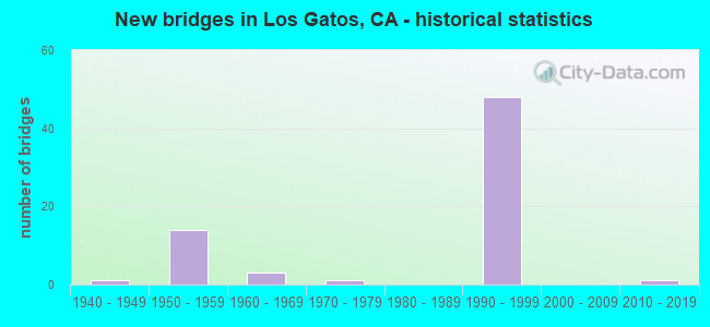
- New bridges - historical statistics
- 11940-1949
- 141950-1959
- 31960-1969
- 11970-1979
- 481990-1999
- 12010-2019
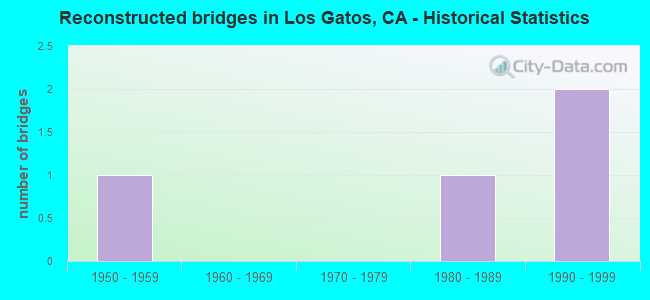
- Reconstructed bridges - Historical Statistics
- 11950-1959
- 01960-1969
- 01970-1979
- 11980-1989
- 21990-1999
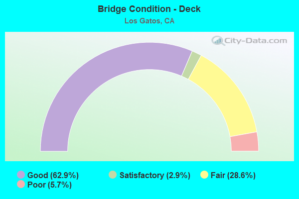
- Bridge Condition - Deck
- 62.9%Good
- 2.9%Satisfactory
- 28.6%Fair
- 5.7%Poor
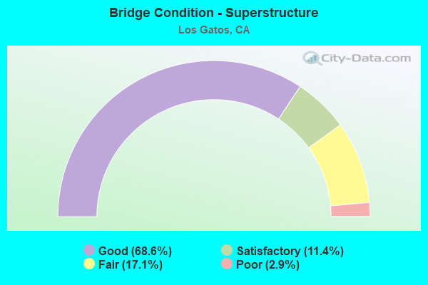
- Bridge Condition - Superstructure
- 68.6%Good
- 11.4%Satisfactory
- 17.1%Fair
- 2.9%Poor
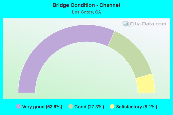
- Bridge Condition - Channel
- 63.6%Very good
- 27.3%Good
- 9.1%Satisfactory
Find on map >> Show street view
Structure Number: 37 0029, Location: 04-SCL-017-5.43 (Lat: 37.209175, Lng: -121.989578), Route carried "on" structure: State highway 17, Year Built: 1940, Status: Open, Structure Length: 28.25m (92.68ft), Average Daily Traffic: 78,000 (year 2017), Average Future Daily Traffic: 93,355 (year 2038), Design Load: HS 20, Features Intersected: HILLSIDE
Minimum Vertical Clearance: 30+ m (98+ ft), Kilometerpoint: 5.430, Lanes on structure: 4, Base Highway Network: Yes (, Subroute: 1), Owner: State Highway Agency, Approaching Roadway Width: 16.7m (54.8ft), Skew: 30 degrees, Material/Design: Steel, Design/Construction: Stringer/Multi-beam, Number Of Spans In Main Unit: 37, Length of Maximum Span: 7.6m (24.9ft), Curb-To-Curb Width: 16.7m (54.8ft), Out-to-Out Width: 7.6m (24.9ft)
Condition: Deck: Good, Superstructure: Good, Substructure: Good, Operating Rating: 22.4 metric tons, Method Used To Determine Operating Rating: Load and Resistance Factor Rating (LRFR) rating reported by rating factor(RF) method using HL-93 loadings, Inventory Rating: 17.2 metric tons, Method Used To Determine Inventory Rating: Load and Resistance Factor Rating (LRFR) rating reported by rating factor(RF) method using HL-93 loadings, Structural Evaluation: Meets minimum limits, Deck Geometry: Meets minimum limits, Approach Roadway Alignment: Equal to present desirable criteria, Designated Inspection Frequency: Every 24 months, Inspection Date: July 2020, Deck Structure Type: Concrete Cast-file-Place, Wearing Surface/Protective System: Wearing Surface: Bituminous
Find on map >> Show street view
Structure Number: 37 0042, Location: 04-SCL-017-6.55-LGTS (Lat: 37.221419, Lng: -121.981889), Route carried "on" structure: State highway 17, Year Built: 1955, Status: Open, Structure Length: 2.59m (8.50ft), Average Daily Traffic: 71,400 (year 2017), Truck Traffic: 10%, Average Future Daily Traffic: 100,000 (year 2038), Features Intersected: LOS GATOS CREEK
Minimum Vertical Clearance: 4.75m (15.58ft), Kilometerpoint: 6.550, Lanes on structure: 4, Base Highway Network: Yes (, Subroute: 1), Owner: State Highway Agency, Approaching Roadway Width: 23.4m (76.8ft), Skew: 26 degrees, Material/Design: Concrete continuous, Design/Construction: Culvert, Number Of Spans In Main Unit: 2, Length of Maximum Span: 5.5m (18.0ft)
Condition: Channel: Good, Culverts: Good, Operating Rating: 54.1 metric tons, Method Used To Determine Operating Rating: Field evaluation and documented engineering judgment, Inventory Rating: 32.4 metric tons, Method Used To Determine Inventory Rating: Field evaluation and documented engineering judgment, Structural Evaluation: Better than present minimum criteria, Waterway Adequacy: Equal to present minimum criteria, Approach Roadway Alignment: Equal to present desirable criteria, Designated Inspection Frequency: Every 48 months, Inspection Date: July 2020
Find on map >> Show street view
Structure Number: 37 0117, Location: 04-SCL-017-6.55-LGTS (Lat: 37.221600, Lng: -121.982186), Route carried "on" structure: City street , Year Built: 1955, Status: Open, Structure Length: 5.86m (19.23ft), Average Daily Traffic: 9,966 (year 2014), Truck Traffic: 3%, Average Future Daily Traffic: 13,000 (year 2038), Design Load: HS 20, Features Intersected: STATE ROUTE 17, Facility Carried by Structure: MAIN STREET
Minimum Vertical Clearance: 30+ m (98+ ft), Kilometerpoint: 0.000, Lanes on structure: 2, Lanes under structure: 4, Owner: State Highway Agency, Approaching Roadway Width: 17.1m (56.1ft), Skew: 1 degrees, Material/Design: Concrete continuous, Design/Construction: Box Beam or Girders - Multiple, Number Of Spans In Main Unit: 2, Number Of Approach Spans: 2, Length of Maximum Span: 25.1m (82.3ft), Curb or Sidewalk Widths: Left: 3.0m (9.8ft), Right: 3.0m (9.8ft), Curb-To-Curb Width: 17.1m (56.1ft), Out-to-Out Width: 23.7m (77.8ft)
Condition: Deck: Good, Superstructure: Good, Substructure: Good, Operating Rating: 43.4 metric tons, Method Used To Determine Operating Rating: Load and Resistance Factor Rating (LRFR) rating reported by rating factor(RF) method using HL-93 loadings, Inventory Rating: 31.1 metric tons, Method Used To Determine Inventory Rating: Load and Resistance Factor Rating (LRFR) rating reported by rating factor(RF) method using HL-93 loadings, Structural Evaluation: Better than present minimum criteria, Deck Geometry: Superior to present desirable criteria, Underclear: Meets minimum limits, Approach Roadway Alignment: Meets minimum limits, Designated Inspection Frequency: Every 24 months, Inspection Date: July 2020, Deck Structure Type: Concrete Cast-file-Place
Find on map >> Show street view
Structure Number: 37 0124L, Location: 04-SCL-017-6.16-LGTS (Lat: 37.218458, Lng: -121.987225), Route carried "on" structure: State highway 17, Year Built: 1956, Status: Open, Structure Length: 16.46m (54.00ft), Average Daily Traffic: 39,400 (year 2017), Average Future Daily Traffic: 51,200 (year 2038), Design Load: HS 20, Features Intersected: SANTA CRUZ AV NB OFF-RMP, Facility Carried by Structure: SANTA CRUZ AVE
Minimum Vertical Clearance: 30+ m (98+ ft), Kilometerpoint: 6.160, Lanes on structure: 2, Lanes under structure: 1, Base Highway Network: Yes (, Subroute: 1), Owner: State Highway Agency, Approaching Roadway Width: 8.8m (28.9ft), Material/Design: Concrete continuous, Design/Construction: Box Beam or Girders - Multiple, Number Of Spans In Main Unit: 4, Number Of Approach Spans: 10, Length of Maximum Span: 33.5m (109.9ft), Curb or Sidewalk Widths: Left: 0.6m (2.0ft), Right: 0.6m (2.0ft), Curb-To-Curb Width: 8.5m (27.9ft), Out-to-Out Width: 10.2m (33.5ft)
Condition: Deck: Good, Superstructure: Good, Substructure: Good, Operating Rating: 34.0 metric tons, Method Used To Determine Operating Rating: Load and Resistance Factor Rating (LRFR) rating reported by rating factor(RF) method using HL-93 loadings, Inventory Rating: 26.2 metric tons, Method Used To Determine Inventory Rating: Load and Resistance Factor Rating (LRFR) rating reported by rating factor(RF) method using HL-93 loadings, Structural Evaluation: Equal to present minimum criteria, Deck Geometry: High priority of corrective action, Underclear: High priority of corrective action, Approach Roadway Alignment: Equal to present desirable criteria, Designated Inspection Frequency: Every 24 months, Inspection Date: July 2020, Deck Structure Type: Concrete Cast-file-Place, Wearing Surface/Protective System: Wearing Surface: Bituminous
Find on map >> Show street view
Structure Number: 37 0138, Location: 04-SCL-009-11.30-LGTS (Lat: 37.227361, Lng: -121.977097), Route carried "on" structure: State highway 9, Year Built: 1956, Year Reconstructed: 1992, Status: Open, Structure Length: 3.97m (13.02ft), Average Daily Traffic: 35,000 (year 2009), Truck Traffic: 3%, Average Future Daily Traffic: 44,003 (year 2041), Design Load: HS 20+Mod, Features Intersected: LOS GATOS CREEK
Minimum Vertical Clearance: 30+ m (98+ ft), Kilometerpoint: 11.300, Lanes on structure: 4, Base Highway Network: Yes (, Subroute: 8), Owner: State Highway Agency, Approaching Roadway Width: 22.6m (74.1ft), Skew: 20 degrees, Material/Design: Concrete continuous, Design/Construction: Tee Beam, Number Of Spans In Main Unit: 3, Length of Maximum Span: 20.4m (66.9ft), Curb or Sidewalk Widths: Left: 1.8m (5.9ft), Right: 0.0m, Curb-To-Curb Width: 22.6m (74.1ft), Out-to-Out Width: 25.2m (82.7ft)
Condition: Deck: Satisfactory, Superstructure: Good, Substructure: Good, Channel: Very good, Operating Rating: 34.0 metric tons, Method Used To Determine Operating Rating: Load and Resistance Factor Rating (LRFR) rating reported by rating factor(RF) method using HL-93 loadings, Inventory Rating: 26.2 metric tons, Method Used To Determine Inventory Rating: Load and Resistance Factor Rating (LRFR) rating reported by rating factor(RF) method using HL-93 loadings, Structural Evaluation: Equal to present minimum criteria, Deck Geometry: Superior to present desirable criteria, Waterway Adequacy: Equal to present desirable criteria, Approach Roadway Alignment: Equal to present desirable criteria, Designated Inspection Frequency: Every 24 months, Inspection Date: September 2021, Deck Structure Type: Concrete Cast-file-Place
Find on map >> Show street view
Structure Number: 37 0144, Location: 04-SCL-009-11.43-LGTS (Lat: 37.226583, Lng: -121.974672), Route carried "on" structure: State highway 9, Year Built: 1957, Year Reconstructed: 1959, Status: Open, Structure Length: 6.00m (19.69ft), Average Daily Traffic: 35,000 (year 2009), Truck Traffic: 3%, Average Future Daily Traffic: 44,003 (year 2041), Design Load: HS 20, Features Intersected: STATE ROUTE 17
Minimum Vertical Clearance: 30+ m (98+ ft), Kilometerpoint: 11.430, Lanes on structure: 4, Lanes under structure: 6, Base Highway Network: Yes (, Subroute: 8), Owner: State Highway Agency, Approaching Roadway Width: 14.6m (47.9ft), Skew: 21 degrees, Material/Design: Concrete continuous, Design/Construction: Tee Beam, Number Of Spans In Main Unit: 4, Length of Maximum Span: 18.4m (60.4ft), Curb or Sidewalk Widths: Left: 1.9m (6.2ft), Right: 0.0m, Curb-To-Curb Width: 17.2m (56.4ft), Out-to-Out Width: 21.6m (70.9ft)
Condition: Deck: Good, Superstructure: Good, Substructure: Good, Operating Rating: 33.4 metric tons, Method Used To Determine Operating Rating: Load and Resistance Factor Rating (LRFR) rating reported by rating factor(RF) method using HL-93 loadings, Inventory Rating: 23.7 metric tons, Method Used To Determine Inventory Rating: Load and Resistance Factor Rating (LRFR) rating reported by rating factor(RF) method using HL-93 loadings, Structural Evaluation: Somewhat better than minimum adequacy, Deck Geometry: Somewhat better than minimum adequacy, Underclear: High priority of corrective action, Approach Roadway Alignment: Better than present minimum criteria, Designated Inspection Frequency: Every 24 months, Inspection Date: September 2021, Deck Structure Type: Concrete Cast-file-Place
Find on map >> Show street view
Structure Number: 37 0148, Location: 04-SCL-017-7.67-LGTS (Lat: 37.234461, Lng: -121.971114), Route carried "on" structure: City street , Year Built: 1959, Year Reconstructed: 1997, Status: Open, Structure Length: 6.26m (20.54ft), Average Daily Traffic: 6,653 (year 2014), Truck Traffic: 3%, Average Future Daily Traffic: 8,600 (year 2038), Design Load: HS 20, Features Intersected: STATE ROUTE 17, Facility Carried by Structure: BLOSSOM HILL ROAD
Minimum Vertical Clearance: 30+ m (98+ ft), Kilometerpoint: 0.000, Lanes on structure: 2, Lanes under structure: 4, Base Highway Network: Yes, Owner: State Highway Agency, Approaching Roadway Width: 9.0m (29.5ft), Skew: 3 degrees, Material/Design: Concrete continuous, Design/Construction: Tee Beam, Number Of Spans In Main Unit: 4, Length of Maximum Span: 19.5m (64.0ft), Curb or Sidewalk Widths: Left: 1.5m (4.9ft), Right: 1.5m (4.9ft), Curb-To-Curb Width: 9.0m (29.5ft), Out-to-Out Width: 12.6m (41.3ft)
Condition: Deck: Good, Superstructure: Good, Substructure: Good, Operating Rating: 47.0 metric tons, Method Used To Determine Operating Rating: Load and Resistance Factor Rating (LRFR) rating reported by rating factor(RF) method using HL-93 loadings, Inventory Rating: 36.3 metric tons, Method Used To Determine Inventory Rating: Load and Resistance Factor Rating (LRFR) rating reported by rating factor(RF) method using HL-93 loadings, Structural Evaluation: Better than present minimum criteria, Deck Geometry: Meets minimum limits, Underclear: Meets minimum limits, Approach Roadway Alignment: Equal to present desirable criteria, Designated Inspection Frequency: Every 48 months, Inspection Date: July 2020, Deck Structure Type: Concrete Cast-file-Place
Find on map >> Show street view
Structure Number: 37 0151, Location: 04-SCL-017-8.89-LGTS (Lat: 37.249581, Lng: -121.959897), Route carried "on" structure: City street , Year Built: 1994, Status: Open, Structure Length: 7.99m (26.21ft), Average Daily Traffic: 23,492 (year 2014), Truck Traffic: 1%, Average Future Daily Traffic: 31,200 (year 2038), Design Load: HS 20+Mod, Features Intersected: STATE ROUTE 17 & RAMPS, Facility Carried by Structure: LARK AVENUE
Minimum Vertical Clearance: 30+ m (98+ ft), Kilometerpoint: 0.000, Lanes on structure: 6, Lanes under structure: 8, Owner: State Highway Agency, Approaching Roadway Width: 24.4m (80.1ft), Skew: 20 degrees, Material/Design: Prestressed concrete continuous, Design/Construction: Box Beam or Girders - Multiple, Number Of Spans In Main Unit: 2, Length of Maximum Span: 41.1m (134.8ft), Curb or Sidewalk Widths: Left: 1.5m (4.9ft), Right: 1.5m (4.9ft), Curb-To-Curb Width: 24.4m (80.1ft), Out-to-Out Width: 29.2m (95.8ft)
Condition: Deck: Good, Superstructure: Fair, Substructure: Good, Operating Rating: 54.1 metric tons, Method Used To Determine Operating Rating: Assigned rating based on Load Factor Design (LFD) reported in metric tons, Inventory Rating: 32.4 metric tons, Method Used To Determine Inventory Rating: Assigned rating based on Load Factor Design (LFD) reported in metric tons, Structural Evaluation: Somewhat better than minimum adequacy, Deck Geometry: Somewhat better than minimum adequacy, Underclear: High priority of corrective action, Approach Roadway Alignment: Equal to present desirable criteria, Designated Inspection Frequency: Every 24 months, Inspection Date: July 2020, Deck Structure Type: Concrete Cast-file-Place
Find on map >> Show street view
Structure Number: 37 0491H, Location: 04-SCL-017-9.42-LGTS (Lat: 37.257939, Lng: -121.961036), Route carried "on" structure: Ramp State highway 17, Year Built: 1994, Status: Open, Structure Length: 5.39m (17.68ft), Average Daily Traffic: 15,100 (year 2013), Truck Traffic: 1%, Average Future Daily Traffic: 19,600 (year 2038), Design Load: HS 20+Mod, Features Intersected: LOS GATOS CREEK
Minimum Vertical Clearance: 30+ m (98+ ft), Kilometerpoint: 9.420, Lanes on structure: 2, Owner: State Highway Agency, Approaching Roadway Width: 11.9m (39.0ft), Material/Design: Prestressed concrete continuous, Design/Construction: Box Beam or Girders - Multiple, Number Of Spans In Main Unit: 2, Length of Maximum Span: 27.0m (88.6ft), Curb-To-Curb Width: 11.9m (39.0ft), Out-to-Out Width: 12.9m (42.3ft)
Condition: Deck: Good, Superstructure: Good, Substructure: Good, Channel: Very good, Operating Rating: 54.1 metric tons, Method Used To Determine Operating Rating: Assigned rating based on Load Factor Design (LFD) reported in metric tons, Inventory Rating: 32.4 metric tons, Method Used To Determine Inventory Rating: Assigned rating based on Load Factor Design (LFD) reported in metric tons, Structural Evaluation: Better than present minimum criteria, Deck Geometry: Superior to present desirable criteria, Waterway Adequacy: Equal to present desirable criteria, Approach Roadway Alignment: Equal to present desirable criteria, Designated Inspection Frequency: Every 48 months, Inspection Date: July 2018, Deck Structure Type: Concrete Cast-file-Place
Find on map >> Show street view
Structure Number: 37 0491L, Location: 04-SCL-085-R10.80-LGTS (Lat: 37.257525, Lng: -121.961203), Route carried "on" structure: State highway 85, Year Built: 1994, Status: Open, Structure Length: 5.41m (17.75ft), Average Daily Traffic: 61,000 (year 2009), Average Future Daily Traffic: 88,180 (year 2037), Design Load: HS 20+Mod, Features Intersected: LOS GATOS CREEK
Minimum Vertical Clearance: 30+ m (98+ ft), Kilometerpoint: 10.800, Lanes on structure: 5, Base Highway Network: Yes (, Subroute: 1), Owner: State Highway Agency, Approaching Roadway Width: 27.5m (90.2ft), Skew: 1 degrees, Material/Design: Prestressed concrete continuous, Design/Construction: Box Beam or Girders - Multiple, Number Of Spans In Main Unit: 2, Length of Maximum Span: 27.1m (88.9ft), Curb-To-Curb Width: 27.5m (90.2ft), Out-to-Out Width: 28.5m (93.5ft)
Condition: Deck: Good, Superstructure: Satisfactory, Substructure: Good, Channel: Very good, Operating Rating: 54.1 metric tons, Method Used To Determine Operating Rating: Assigned rating based on Load Factor Design (LFD) reported in metric tons, Inventory Rating: 32.4 metric tons, Method Used To Determine Inventory Rating: Assigned rating based on Load Factor Design (LFD) reported in metric tons, Structural Evaluation: Equal to present minimum criteria, Deck Geometry: Superior to present desirable criteria, Waterway Adequacy: Equal to present desirable criteria, Approach Roadway Alignment: Equal to present desirable criteria, Designated Inspection Frequency: Every 48 months, Inspection Date: August 2020, Deck Structure Type: Concrete Cast-file-Place
Find on map >> Show street view
Structure Number: 37 0491R, Location: 04-SCL-085-R10.80-LGTS (Lat: 37.257753, Lng: -121.961114), Route carried "on" structure: State highway 85, Year Built: 1994, Status: Open, Structure Length: 5.41m (17.75ft), Average Daily Traffic: 61,000 (year 2009), Average Future Daily Traffic: 88,180 (year 2037), Design Load: HS 20+Mod, Features Intersected: LOS GATOS CREEK
Minimum Vertical Clearance: 30+ m (98+ ft), Kilometerpoint: 10.800, Lanes on structure: 3, Base Highway Network: Yes (, Subroute: 1), Owner: State Highway Agency, Approaching Roadway Width: 17.1m (56.1ft), Material/Design: Prestressed concrete continuous, Design/Construction: Box Beam or Girders - Multiple, Number Of Spans In Main Unit: 2, Length of Maximum Span: 27.1m (88.9ft), Curb-To-Curb Width: 17.1m (56.1ft), Out-to-Out Width: 18.1m (59.4ft)
Condition: Deck: Good, Superstructure: Satisfactory, Substructure: Good, Channel: Very good, Operating Rating: 54.1 metric tons, Method Used To Determine Operating Rating: Assigned rating based on Load Factor Design (LFD) reported in metric tons, Inventory Rating: 32.4 metric tons, Method Used To Determine Inventory Rating: Assigned rating based on Load Factor Design (LFD) reported in metric tons, Structural Evaluation: Equal to present minimum criteria, Deck Geometry: Superior to present desirable criteria, Waterway Adequacy: Equal to present desirable criteria, Approach Roadway Alignment: Equal to present desirable criteria, Designated Inspection Frequency: Every 24 months, Inspection Date: August 2020, Deck Structure Type: Concrete Cast-file-Place
Find on map >> Show street view
Structure Number: 37 0493, Location: 04-SCL-017-9.32-LGTS (Lat: 37.255175, Lng: -121.956125), Route carried "on" structure: State highway 17, Year Built: 1994, Status: Open, Structure Length: 12.31m (40.39ft), Average Daily Traffic: 101,900 (year 2017), Truck Traffic: 7%, Average Future Daily Traffic: 132,500 (year 2038), Design Load: HS 20+Mod, Features Intersected: STATE ROUTE 85 & RAMPS
Minimum Vertical Clearance: 30+ m (98+ ft), Kilometerpoint: 9.320, Lanes on structure: 5, Lanes under structure: 16, Base Highway Network: Yes (, Subroute: 1), Owner: State Highway Agency, Approaching Roadway Width: 42.3m (138.8ft), Skew: 30 degrees, Material/Design: Prestressed concrete continuous, Design/Construction: Box Beam or Girders - Multiple, Number Of Spans In Main Unit: 2, Length of Maximum Span: 61.2m (200.8ft), Curb-To-Curb Width: 42.3m (138.8ft), Out-to-Out Width: 43.9m (144.0ft)
Condition: Deck: Good, Superstructure: Good, Substructure: Good, Operating Rating: 54.1 metric tons, Method Used To Determine Operating Rating: Assigned rating based on Load Factor Design (LFD) reported in metric tons, Inventory Rating: 32.4 metric tons, Method Used To Determine Inventory Rating: Assigned rating based on Load Factor Design (LFD) reported in metric tons, Structural Evaluation: Better than present minimum criteria, Deck Geometry: Superior to present desirable criteria, Underclear: Equal to present minimum criteria, Approach Roadway Alignment: Equal to present desirable criteria, Designated Inspection Frequency: Every 24 months, Inspection Date: July 2020, Deck Structure Type: Concrete Cast-file-Place
Find on map >> Show street view
Structure Number: 37 0493H, Location: 04-SCL-017-9.32-LGTS (Lat: 37.255117, Lng: -121.955964), Route carried "on" structure: Ramp State highway 17, Year Built: 1994, Status: Open, Structure Length: 12.40m (40.68ft), Average Daily Traffic: 24,700 (year 2013), Truck Traffic: 2%, Average Future Daily Traffic: 32,199 (year 2037), Design Load: HS 20+Mod, Features Intersected: STATE ROUTE 85 & RAMPS
Minimum Vertical Clearance: 30+ m (98+ ft), Kilometerpoint: 9.320, Lanes on structure: 2, Lanes under structure: 15, Owner: State Highway Agency, Approaching Roadway Width: 11.0m (36.1ft), Material/Design: Prestressed concrete continuous, Design/Construction: Box Beam or Girders - Multiple, Number Of Spans In Main Unit: 2, Length of Maximum Span: 61.7m (202.4ft), Curb-To-Curb Width: 11.0m (36.1ft), Out-to-Out Width: 12.0m (39.4ft)
Condition: Deck: Good, Superstructure: Good, Substructure: Good, Operating Rating: 54.1 metric tons, Method Used To Determine Operating Rating: Assigned rating based on Load Factor Design (LFD) reported in metric tons, Inventory Rating: 32.4 metric tons, Method Used To Determine Inventory Rating: Assigned rating based on Load Factor Design (LFD) reported in metric tons, Structural Evaluation: Better than present minimum criteria, Deck Geometry: Better than present minimum criteria, Underclear: Equal to present minimum criteria, Approach Roadway Alignment: Equal to present desirable criteria, Designated Inspection Frequency: Every 24 months, Inspection Date: July 2020, Deck Structure Type: Concrete Cast-file-Place
Find on map >> Show street view
Structure Number: 37 0494F, Location: 04-SCL-017-9.34 (Lat: 37.254797, Lng: -121.953944), Route carried "on" structure: Ramp State highway 17, Year Built: 1994, Status: Open, Structure Length: 15.79m (51.80ft), Average Daily Traffic: 22,400 (year 2010), Truck Traffic: 10%, Average Future Daily Traffic: 29,000 (year 2038), Design Load: HS 20+Mod, Features Intersected: STATE ROUTE 85 & RAMPS
Minimum Vertical Clearance: 30+ m (98+ ft), Kilometerpoint: 9.340, Lanes on structure: 2, Lanes under structure: 14, Owner: State Highway Agency, Approaching Roadway Width: 11.9m (39.0ft), Skew: 9 degrees, Material/Design: Prestressed concrete continuous, Design/Construction: Box Beam or Girders - Multiple, Number Of Spans In Main Unit: 3, Length of Maximum Span: 70.7m (232.0ft), Curb-To-Curb Width: 11.9m (39.0ft), Out-to-Out Width: 12.9m (42.3ft)
Condition: Deck: Fair, Superstructure: Good, Substructure: Good, Operating Rating: 54.1 metric tons, Method Used To Determine Operating Rating: Assigned rating based on Load Factor Design (LFD) reported in metric tons, Inventory Rating: 32.4 metric tons, Method Used To Determine Inventory Rating: Assigned rating based on Load Factor Design (LFD) reported in metric tons, Structural Evaluation: Better than present minimum criteria, Deck Geometry: Superior to present desirable criteria, Underclear: Equal to present minimum criteria, Approach Roadway Alignment: Superior to present desirable criteria, Designated Inspection Frequency: Every 24 months, Inspection Date: July 2020, Deck Structure Type: Concrete Cast-file-Place
Find on map >> Show street view
Structure Number: 37 0495K, Location: 04-SCL-085-R10.30-LGTS (Lat: 37.254097, Lng: -121.952633), Route carried "on" structure: Ramp State highway 85, Year Built: 1994, Status: Open, Structure Length: 9.91m (32.51ft), Average Daily Traffic: 4,300 (year 2001), Truck Traffic: 2%, Average Future Daily Traffic: 6,894 (year 2041), Design Load: HS 20+Mod, Features Intersected: 17-SB 85 CONNECTOR NB
Minimum Vertical Clearance: 30+ m (98+ ft), Kilometerpoint: 10.300, Lanes on structure: 2, Lanes under structure: 1, Base Highway Network: Yes (, Subroute: 1), Owner: State Highway Agency, Approaching Roadway Width: 11.0m (36.1ft), Material/Design: Prestressed concrete continuous, Design/Construction: Box Beam or Girders - Multiple, Number Of Spans In Main Unit: 3, Length of Maximum Span: 42.1m (138.1ft), Curb-To-Curb Width: 11.0m (36.1ft), Out-to-Out Width: 12.1m (39.7ft)
Condition: Deck: Fair, Superstructure: Good, Substructure: Good, Operating Rating: 54.1 metric tons, Method Used To Determine Operating Rating: Assigned rating based on Load Factor Design (LFD) reported in metric tons, Inventory Rating: 32.4 metric tons, Method Used To Determine Inventory Rating: Assigned rating based on Load Factor Design (LFD) reported in metric tons, Structural Evaluation: Better than present minimum criteria, Deck Geometry: Better than present minimum criteria, Underclear: Somewhat better than minimum adequacy, Approach Roadway Alignment: Equal to present desirable criteria, Designated Inspection Frequency: Every 24 months, Inspection Date: September 2021, Deck Structure Type: Concrete Cast-file-Place
Find on map >> Show street view
Structure Number: 37 0496S, Location: 04-SCL-085-R10.30-LGTS (Lat: 37.255353, Lng: -121.951708), Route carried "on" structure: Ramp State highway 85, Year Built: 1994, Status: Open, Structure Length: 10.15m (33.30ft), Average Daily Traffic: 6,300 (year 2001), Truck Traffic: 2%, Average Future Daily Traffic: 10,305 (year 2041), Design Load: HS 20+Mod, Features Intersected: NB85-NB17 & NB85-SB17, Facility Carried by Structure: BASCOM AVE ON RAMP
Minimum Vertical Clearance: 30+ m (98+ ft), Kilometerpoint: 10.300, Lanes on structure: 3, Lanes under structure: 3, Base Highway Network: Yes (, Subroute: 1), Owner: State Highway Agency, Approaching Roadway Width: 11.0m (36.1ft), Material/Design: Prestressed concrete continuous, Design/Construction: Box Beam or Girders - Multiple, Number Of Spans In Main Unit: 3, Length of Maximum Span: 46.1m (151.2ft), Curb-To-Curb Width: 11.0m (36.1ft), Out-to-Out Width: 12.0m (39.4ft)
Condition: Deck: Fair, Superstructure: Good, Substructure: Good, Operating Rating: 54.1 metric tons, Method Used To Determine Operating Rating: Assigned rating based on Load Factor Design (LFD) reported in metric tons, Inventory Rating: 32.4 metric tons, Method Used To Determine Inventory Rating: Assigned rating based on Load Factor Design (LFD) reported in metric tons, Structural Evaluation: Better than present minimum criteria, Deck Geometry: High priority of replacement, Underclear: Equal to present minimum criteria, Approach Roadway Alignment: Equal to present desirable criteria, Designated Inspection Frequency: Every 24 months, Inspection Date: September 2021, Deck Structure Type: Concrete Cast-file-Place
Find on map >> Show street view
Structure Number: 37 0497, Location: 04-SCL-085-R10.24-LGTS (Lat: 37.253939, Lng: -121.951583), Route carried "on" structure: City street , Year Built: 1994, Status: Open, Structure Length: 13.79m (45.24ft), Average Daily Traffic: 33,500 (year 2000), Truck Traffic: 2%, Average Future Daily Traffic: 53,886 (year 2041), Design Load: HS 20+Mod, Features Intersected: STATE ROUTE 85, Facility Carried by Structure: BASCOM AVENUE
Minimum Vertical Clearance: 30+ m (98+ ft), Kilometerpoint: 0.000, Lanes on structure: 8, Lanes under structure: 15, Base Highway Network: Yes, Owner: State Highway Agency, Approaching Roadway Width: 29.9m (98.1ft), Skew: 22 degrees, Material/Design: Prestressed concrete continuous, Design/Construction: Box Beam or Girders - Multiple, Number Of Spans In Main Unit: 4, Length of Maximum Span: 39.2m (128.6ft), Curb or Sidewalk Widths: Left: 1.5m (4.9ft), Right: 1.5m (4.9ft), Curb-To-Curb Width: 29.9m (98.1ft), Out-to-Out Width: 34.1m (111.9ft)
Condition: Deck: Good, Superstructure: Good, Substructure: Good, Operating Rating: 54.1 metric tons, Method Used To Determine Operating Rating: Assigned rating based on Load Factor Design (LFD) reported in metric tons, Inventory Rating: 32.4 metric tons, Method Used To Determine Inventory Rating: Assigned rating based on Load Factor Design (LFD) reported in metric tons, Structural Evaluation: Better than present minimum criteria, Deck Geometry: Meets minimum limits, Underclear: Better than present minimum criteria, Approach Roadway Alignment: Equal to present desirable criteria, Designated Inspection Frequency: Every 24 months, Inspection Date: September 2021, Deck Structure Type: Concrete Cast-file-Place
Find on map >> Show street view
Structure Number: 37 0498S, Location: 04-SCL-017-8.98-LGTS (Lat: 37.249906, Lng: -121.958575), Route carried "on" structure: Ramp State highway 17, Year Built: 1994, Status: Open, Structure Length: 14.42m (47.31ft), Average Daily Traffic: 11,200 (year 2010), Truck Traffic: 5%, Average Future Daily Traffic: 14,600 (year 2037), Design Load: HS 20+Mod, Features Intersected: N17-N&S85 CONNECTOR RAMP
Minimum Vertical Clearance: 30+ m (98+ ft), Kilometerpoint: 8.980, Lanes on structure: 2, Lanes under structure: 2, Owner: State Highway Agency, Approaching Roadway Width: 8.8m (28.9ft), Material/Design: Prestressed concrete continuous, Design/Construction: Box Beam or Girders - Multiple, Number Of Spans In Main Unit: 3, Length of Maximum Span: 57.3m (188.0ft), Curb-To-Curb Width: 8.8m (28.9ft), Out-to-Out Width: 9.8m (32.2ft)
Condition: Deck: Good, Superstructure: Good, Substructure: Good, Operating Rating: 54.1 metric tons, Method Used To Determine Operating Rating: Assigned rating based on Load Factor Design (LFD) reported in metric tons, Inventory Rating: 32.4 metric tons, Method Used To Determine Inventory Rating: Assigned rating based on Load Factor Design (LFD) reported in metric tons, Structural Evaluation: Better than present minimum criteria, Deck Geometry: Meets minimum limits, Underclear: Superior to present desirable criteria, Approach Roadway Alignment: Equal to present desirable criteria, Designated Inspection Frequency: Every 24 months, Inspection Date: July 2020, Deck Structure Type: Concrete Cast-file-Place
Find on map >> Show street view
Structure Number: 37 0514, Location: 04-SCL-085-9.28-SJS (Lat: 37.250650, Lng: -121.931158), Route carried "on" structure: City street , Year Built: 1994, Status: Open, Structure Length: 7.21m (23.65ft), Average Daily Traffic: 17,800 (year 2000), Truck Traffic: 1%, Average Future Daily Traffic: 28,632 (year 2041), Design Load: HS 20+Mod, Features Intersected: STATE ROUTE 85, Facility Carried by Structure: UNION AVENUE
Minimum Vertical Clearance: 30+ m (98+ ft), Kilometerpoint: 0.000, Lanes on structure: 7, Lanes under structure: 7, Owner: State Highway Agency, Approaching Roadway Width: 18.3m (60.0ft), Skew: 21 degrees, Material/Design: Prestressed concrete continuous, Design/Construction: Box Beam or Girders - Multiple, Number Of Spans In Main Unit: 2, Length of Maximum Span: 40.3m (132.2ft), Curb or Sidewalk Widths: Left: 1.5m (4.9ft), Right: 1.5m (4.9ft), Curb-To-Curb Width: 27.1m (88.9ft), Out-to-Out Width: 31.4m (103.0ft)
Condition: Deck: Fair, Superstructure: Good, Substructure: Good, Operating Rating: 54.1 metric tons, Method Used To Determine Operating Rating: Assigned rating based on Load Factor Design (LFD) reported in metric tons, Inventory Rating: 32.4 metric tons, Method Used To Determine Inventory Rating: Assigned rating based on Load Factor Design (LFD) reported in metric tons, Structural Evaluation: Better than present minimum criteria, Deck Geometry: Somewhat better than minimum adequacy, Underclear: Somewhat better than minimum adequacy, Approach Roadway Alignment: Better than present minimum criteria, Designated Inspection Frequency: Every 24 months, Inspection Date: September 2021, Deck Structure Type: Concrete Cast-file-Place
Find on map >> Show street view
Structure Number: 37 0515G, Location: 04-SCL-017-9.24-LGTS (Lat: 37.254828, Lng: -121.956358), Route carried "on" structure: State highway 17, Year Built: 1994, Status: Open, Structure Length: 1.58m (5.18ft), Average Daily Traffic: 101,900 (year 2017), Truck Traffic: 7%, Average Future Daily Traffic: 132,500 (year 2038), Design Load: HS 20+Mod, Features Intersected: ABANDONED N17-N85 CONN
Minimum Vertical Clearance: 30+ m (98+ ft), Kilometerpoint: 9.240, Lanes on structure: 6, Base Highway Network: Yes (, Subroute: 1), Owner: State Highway Agency, Approaching Roadway Width: 30.8m (101.0ft), Skew: 5 degrees, Material/Design: Concrete, Design/Construction: Box Beam or Girders - Multiple, Number Of Spans In Main Unit: 1, Length of Maximum Span: 13.9m (45.6ft), Curb-To-Curb Width: 30.8m (101.0ft), Out-to-Out Width: 32.0m (105.0ft)
Condition: Deck: Good, Superstructure: Fair, Substructure: Good, Operating Rating: 54.1 metric tons, Method Used To Determine Operating Rating: Assigned rating based on Load Factor Design (LFD) reported in metric tons, Inventory Rating: 32.4 metric tons, Method Used To Determine Inventory Rating: Assigned rating based on Load Factor Design (LFD) reported in metric tons, Structural Evaluation: Somewhat better than minimum adequacy, Deck Geometry: Superior to present desirable criteria, Approach Roadway Alignment: Equal to present desirable criteria, Designated Inspection Frequency: Every 24 months, Inspection Date: July 2020
Find on map >> Show street view
Structure Number: 37 0516F, Location: 04-SCL-017-9.50-LGTS (Lat: 37.256433, Lng: -121.954981), Route carried "on" structure: State highway 17, Year Built: 1994, Status: Open, Structure Length: 1.60m (5.25ft), Average Daily Traffic: 139,700 (year 2017), Truck Traffic: 7%, Average Future Daily Traffic: 182,000 (year 2038), Design Load: HS 20+Mod, Features Intersected: S17-S85 CONNECTOR RAMP
Minimum Vertical Clearance: 4.97m (16.31ft), Kilometerpoint: 9.500, Lanes on structure: 5, Lanes under structure: 2, Base Highway Network: Yes (, Subroute: 1), Owner: State Highway Agency, Approaching Roadway Width: 37.8m (124.0ft), Skew: 25 degrees, Material/Design: Concrete, Design/Construction: Box Beam or Girders - Multiple, Number Of Spans In Main Unit: 1, Length of Maximum Span: 13.9m (45.6ft), Curb-To-Curb Width: 37.8m (124.0ft), Out-to-Out Width: 39.0m (128.0ft)
Condition: Deck: Good, Superstructure: Good, Substructure: Good, Operating Rating: 54.1 metric tons, Method Used To Determine Operating Rating: Assigned rating based on Load Factor Design (LFD) reported in metric tons, Inventory Rating: 32.4 metric tons, Method Used To Determine Inventory Rating: Assigned rating based on Load Factor Design (LFD) reported in metric tons, Structural Evaluation: Better than present minimum criteria, Deck Geometry: Somewhat better than minimum adequacy, Underclear: Meets minimum limits, Approach Roadway Alignment: Better than present minimum criteria, Designated Inspection Frequency: Every 24 months, Inspection Date: July 2020, Deck Structure Type: Concrete Cast-file-Place, Wearing Surface/Protective System: Wearing Surface: Bituminous
Find on map >> Show street view
Structure Number: 37 0519, Location: 04-SCL-085-R11.00-LGTS (Lat: 37.258253, Lng: -121.964283), Route carried "on" structure: City street C018, Year Built: 1994, Status: Open, Structure Length: 7.44m (24.41ft), Average Daily Traffic: 8,000 (year 1998), Truck Traffic: 1%, Average Future Daily Traffic: 29,927 (year 2037), Design Load: HS 20+Mod, Features Intersected: STATE ROUTE 85, Facility Carried by Structure: WINCHESTER BLVD
Minimum Vertical Clearance: 30+ m (98+ ft), Kilometerpoint: 0.000, Lanes on structure: 4, Lanes under structure: 9, Base Highway Network: Yes, Owner: State Highway Agency, Approaching Roadway Width: 28.3m (92.8ft), Skew: 20 degrees, Material/Design: Prestressed concrete continuous, Design/Construction: Box Beam or Girders - Multiple, Number Of Spans In Main Unit: 2, Length of Maximum Span: 36.6m (120.1ft), Curb or Sidewalk Widths: Left: 1.8m (5.9ft), Right: 0.0m, Curb-To-Curb Width: 20.8m (68.2ft), Out-to-Out Width: 28.3m (92.8ft)
Condition: Deck: Fair, Superstructure: Good, Substructure: Good, Operating Rating: 54.1 metric tons, Method Used To Determine Operating Rating: Assigned rating based on Load Factor Design (LFD) reported in metric tons, Inventory Rating: 32.4 metric tons, Method Used To Determine Inventory Rating: Assigned rating based on Load Factor Design (LFD) reported in metric tons, Structural Evaluation: Better than present minimum criteria, Deck Geometry: Superior to present desirable criteria, Underclear: Better than present minimum criteria, Approach Roadway Alignment: Equal to present desirable criteria, Designated Inspection Frequency: Every 24 months, Inspection Date: August 2020, Deck Structure Type: Concrete Cast-file-Place
Find on map >> Show street view
Structure Number: 37 0520R, Location: 04-SCL-085-R11.97-LGTS (Lat: 37.264769, Lng: -121.979567), Route carried "on" structure: State highway 85, Year Built: 1994, Status: Open, Structure Length: 5.55m (18.21ft), Average Daily Traffic: 57,500 (year 2009), Truck Traffic: 3%, Average Future Daily Traffic: 76,512 (year 2037), Design Load: HS 20+Mod, Features Intersected: POLLARD ROAD
Minimum Vertical Clearance: 5.91m (19.39ft), Kilometerpoint: 11.970, Lanes on structure: 3, Lanes under structure: 4, Base Highway Network: Yes (, Subroute: 1), Owner: State Highway Agency, Approaching Roadway Width: 17.1m (56.1ft), Skew: 5 degrees, Material/Design: Prestressed concrete, Design/Construction: Box Beam or Girders - Multiple, Number Of Spans In Main Unit: 1, Length of Maximum Span: 55.5m (182.1ft), Curb-To-Curb Width: 17.1m (56.1ft), Out-to-Out Width: 18.1m (59.4ft)
Condition: Deck: Fair, Superstructure: Good, Substructure: Good, Operating Rating: 54.1 metric tons, Method Used To Determine Operating Rating: Assigned rating based on Load Factor Design (LFD) reported in metric tons, Inventory Rating: 32.4 metric tons, Method Used To Determine Inventory Rating: Assigned rating based on Load Factor Design (LFD) reported in metric tons, Structural Evaluation: Better than present minimum criteria, Deck Geometry: Superior to present desirable criteria, Underclear: Meets minimum limits, Approach Roadway Alignment: Equal to present desirable criteria, Designated Inspection Frequency: Every 24 months, Inspection Date: August 2020, Deck Structure Type: Concrete Cast-file-Place
Find on map >> Show street view
Structure Number: 37 0536F, Location: 04-SCL-017-9.45-LGTS (Lat: 37.257308, Lng: -121.956831), Route carried "on" structure: Ramp State highway 17, Year Built: 1994, Status: Open, Structure Length: 7.99m (26.21ft), Average Daily Traffic: 6,700 (year 2010), Truck Traffic: 1%, Average Future Daily Traffic: 8,700 (year 2038), Design Load: HS 20+Mod, Features Intersected: OKA ROAD
Minimum Vertical Clearance: 30+ m (98+ ft), Kilometerpoint: 9.450, Lanes on structure: 2, Lanes under structure: 2, Owner: State Highway Agency, Approaching Roadway Width: 10.4m (34.1ft), Material/Design: Prestressed concrete continuous, Design/Construction: Box Beam or Girders - Multiple, Number Of Spans In Main Unit: 2, Length of Maximum Span: 41.2m (135.2ft), Curb-To-Curb Width: 10.4m (34.1ft), Out-to-Out Width: 11.4m (37.4ft)
Condition: Deck: Good, Superstructure: Good, Substructure: Good, Operating Rating: 54.1 metric tons, Method Used To Determine Operating Rating: Assigned rating based on Load Factor Design (LFD) reported in metric tons, Inventory Rating: 32.4 metric tons, Method Used To Determine Inventory Rating: Assigned rating based on Load Factor Design (LFD) reported in metric tons, Structural Evaluation: Better than present minimum criteria, Deck Geometry: Better than present minimum criteria, Underclear: Meets minimum limits, Approach Roadway Alignment: Superior to present desirable criteria, Designated Inspection Frequency: Every 24 months, Inspection Date: July 2020, Deck Structure Type: Concrete Cast-file-Place
Find on map >> Show street view
Structure Number: 37 0537G, Location: 04-SCL-017-9.43-LGTS (Lat: 37.256783, Lng: -121.957561), Route carried "on" structure: Ramp State highway 17, Year Built: 1994, Status: Open, Structure Length: 3.99m (13.09ft), Average Daily Traffic: 15,100 (year 2013), Truck Traffic: 4%, Average Future Daily Traffic: 19,600 (year 2038), Design Load: HS 20+Mod, Features Intersected: OKA ROAD
Minimum Vertical Clearance: 30+ m (98+ ft), Kilometerpoint: 9.430, Lanes on structure: 1, Lanes under structure: 2, Owner: State Highway Agency, Approaching Roadway Width: 7.3m (24.0ft), Skew: 1 degrees, Material/Design: Prestressed concrete, Design/Construction: Box Beam or Girders - Multiple, Number Of Spans In Main Unit: 1, Length of Maximum Span: 38.5m (126.3ft), Curb-To-Curb Width: 7.3m (24.0ft), Out-to-Out Width: 8.4m (27.6ft)
Condition: Deck: Good, Superstructure: Good, Substructure: Good, Operating Rating: 54.1 metric tons, Method Used To Determine Operating Rating: Assigned rating based on Load Factor Design (LFD) reported in metric tons, Inventory Rating: 32.4 metric tons, Method Used To Determine Inventory Rating: Assigned rating based on Load Factor Design (LFD) reported in metric tons, Structural Evaluation: Better than present minimum criteria, Deck Geometry: Better than present minimum criteria, Approach Roadway Alignment: Better than present minimum criteria, Designated Inspection Frequency: Every 24 months, Inspection Date: July 2020, Deck Structure Type: Concrete Cast-file-Place
Find on map >> Show street view
Structure Number: 37 0537L, Location: 04-SCL-085-R10.60-LGTS (Lat: 37.256375, Lng: -121.957964), Route carried "on" structure: State highway 85, Year Built: 1994, Status: Open, Structure Length: 3.11m (10.20ft), Average Daily Traffic: 61,000 (year 2009), Average Future Daily Traffic: 89,958 (year 2040), Design Load: HS 20+Mod, Features Intersected: OKA ROAD
Minimum Vertical Clearance: 5.91m (19.39ft), Kilometerpoint: 10.600, Lanes on structure: 3, Lanes under structure: 2, Base Highway Network: Yes (, Subroute: 1), Owner: State Highway Agency, Approaching Roadway Width: 16.5m (54.1ft), Material/Design: Prestressed concrete, Design/Construction: Box Beam or Girders - Multiple, Number Of Spans In Main Unit: 1, Length of Maximum Span: 31.1m (102.0ft), Curb-To-Curb Width: 16.5m (54.1ft), Out-to-Out Width: 17.5m (57.4ft)
Condition: Deck: Fair, Superstructure: Fair, Substructure: Good, Operating Rating: 54.1 metric tons, Method Used To Determine Operating Rating: Assigned rating based on Load Factor Design (LFD) reported in metric tons, Inventory Rating: 32.4 metric tons, Method Used To Determine Inventory Rating: Assigned rating based on Load Factor Design (LFD) reported in metric tons, Structural Evaluation: Somewhat better than minimum adequacy, Deck Geometry: Better than present minimum criteria, Underclear: Meets minimum limits, Approach Roadway Alignment: Equal to present desirable criteria, Designated Inspection Frequency: Every 24 months, Inspection Date: August 2020, Deck Structure Type: Concrete Cast-file-Place
Find on map >> Show street view
Structure Number: 37 0537R, Location: 04-SCL-085-R10.60-LGTS (Lat: 37.256611, Lng: -121.957808), Route carried "on" structure: State highway 85, Year Built: 1994, Status: Open, Structure Length: 2.96m (9.71ft), Average Daily Traffic: 61,000 (year 2009), Average Future Daily Traffic: 89,958 (year 2040), Design Load: HS 20+Mod, Features Intersected: OKA ROAD
Minimum Vertical Clearance: 4.97m (16.31ft), Kilometerpoint: 10.600, Lanes on structure: 3, Lanes under structure: 2, Base Highway Network: Yes (, Subroute: 1), Owner: State Highway Agency, Approaching Roadway Width: 16.5m (54.1ft), Material/Design: Prestressed concrete, Design/Construction: Box Beam or Girders - Multiple, Number Of Spans In Main Unit: 1, Length of Maximum Span: 29.6m (97.1ft), Curb-To-Curb Width: 16.5m (54.1ft), Out-to-Out Width: 17.5m (57.4ft)
Condition: Deck: Fair, Superstructure: Fair, Substructure: Good, Operating Rating: 54.1 metric tons, Method Used To Determine Operating Rating: Assigned rating based on Load Factor Design (LFD) reported in metric tons, Inventory Rating: 32.4 metric tons, Method Used To Determine Inventory Rating: Assigned rating based on Load Factor Design (LFD) reported in metric tons, Structural Evaluation: Somewhat better than minimum adequacy, Deck Geometry: Better than present minimum criteria, Underclear: Meets minimum limits, Approach Roadway Alignment: Equal to present desirable criteria, Designated Inspection Frequency: Every 24 months, Inspection Date: August 2020, Deck Structure Type: Concrete Cast-file-Place
Find on map >> Show street view
Structure Number: 37 0538F, Location: 04-SCL-085-R10.60-LGTS (Lat: 37.256136, Lng: -121.958167), Route carried "on" structure: Ramp State highway 85, Year Built: 1994, Status: Open, Structure Length: 2.87m (9.42ft), Average Daily Traffic: 5,900 (year 2001), Truck Traffic: 3%, Average Future Daily Traffic: 9,428 (year 2040), Design Load: HS 20+Mod, Features Intersected: OKA ROAD
Minimum Vertical Clearance: 5.13m (16.83ft), Kilometerpoint: 10.600, Lanes on structure: 1, Lanes under structure: 2, Base Highway Network: Yes (, Subroute: 1), Owner: State Highway Agency, Approaching Roadway Width: 7.3m (24.0ft), Material/Design: Prestressed concrete, Design/Construction: Box Beam or Girders - Multiple, Number Of Spans In Main Unit: 1, Length of Maximum Span: 28.7m (94.2ft), Curb-To-Curb Width: 7.3m (24.0ft), Out-to-Out Width: 8.3m (27.2ft)
Condition: Deck: Good, Superstructure: Good, Substructure: Good, Operating Rating: 54.1 metric tons, Method Used To Determine Operating Rating: Assigned rating based on Load Factor Design (LFD) reported in metric tons, Inventory Rating: 32.4 metric tons, Method Used To Determine Inventory Rating: Assigned rating based on Load Factor Design (LFD) reported in metric tons, Structural Evaluation: Better than present minimum criteria, Deck Geometry: Better than present minimum criteria, Underclear: Meets minimum limits, Approach Roadway Alignment: Equal to present desirable criteria, Designated Inspection Frequency: Every 48 months, Inspection Date: August 2018, Deck Structure Type: Concrete Cast-file-Place
Find on map >> Show street view
Structure Number: 37 0539F, Location: 04-SCL-085-R10.60-LGTS (Lat: 37.255983, Lng: -121.958233), Route carried "on" structure: Ramp State highway 85, Year Built: 1994, Status: Open, Structure Length: 3.26m (10.70ft), Average Daily Traffic: 11,000 (year 2001), Truck Traffic: 3%, Average Future Daily Traffic: 17,579 (year 2040), Design Load: HS 20+Mod, Features Intersected: OKA ROAD
Minimum Vertical Clearance: 6.57m (21.56ft), Kilometerpoint: 10.600, Lanes on structure: 1, Lanes under structure: 2, Base Highway Network: Yes (, Subroute: 1), Owner: State Highway Agency, Approaching Roadway Width: 7.3m (24.0ft), Material/Design: Prestressed concrete, Design/Construction: Box Beam or Girders - Multiple, Number Of Spans In Main Unit: 1, Length of Maximum Span: 32.6m (107.0ft), Curb-To-Curb Width: 7.3m (24.0ft), Out-to-Out Width: 8.4m (27.6ft)
Condition: Deck: Good, Superstructure: Good, Substructure: Good, Operating Rating: 54.1 metric tons, Method Used To Determine Operating Rating: Assigned rating based on Load Factor Design (LFD) reported in metric tons, Inventory Rating: 32.4 metric tons, Method Used To Determine Inventory Rating: Assigned rating based on Load Factor Design (LFD) reported in metric tons, Structural Evaluation: Better than present minimum criteria, Deck Geometry: Better than present minimum criteria, Underclear: Meets minimum limits, Approach Roadway Alignment: Superior to present desirable criteria, Designated Inspection Frequency: Every 24 months, Inspection Date: August 2020, Deck Structure Type: Concrete Cast-file-Place
Find on map >> Show street view
Structure Number: 37C0014, Location: NEAR EDELEN AVE (Lat: 37.224239, Lng: -121.979625), Route carried "on" structure: City street , Year Built: 1956, Status: Open, Structure Length: 2.09m (6.86ft), Average Daily Traffic: 650 (year 2010), Truck Traffic: 2%, Average Future Daily Traffic: 767 (year 2042), Design Load: HS 20, Features Intersected: LOS GATOS CREEK, Facility Carried by Structure: MILES AVE
Minimum Vertical Clearance: 30+ m (98+ ft), Kilometerpoint: 0.000, Lanes on structure: 2, Owner: City or Municipal Highway Agency, Approaching Roadway Width: 7.3m (24.0ft), Material/Design: Steel, Design/Construction: Stringer/Multi-beam, Number Of Spans In Main Unit: 1, Length of Maximum Span: 19.1m (62.7ft), Curb or Sidewalk Widths: Left: 1.6m (5.2ft), Right: 0.6m (2.0ft), Curb-To-Curb Width: 7.9m (25.9ft), Out-to-Out Width: 10.6m (34.8ft)
Condition: Deck: Poor, Superstructure: Fair, Substructure: Good, Channel: Very good, Operating Rating: 74.5 metric tons, Method Used To Determine Operating Rating: Load Factor (LF), Inventory Rating: 44.7 metric tons, Method Used To Determine Inventory Rating: Load Factor (LF), Structural Evaluation: Somewhat better than minimum adequacy, Deck Geometry: Somewhat better than minimum adequacy, Waterway Adequacy: Equal to present desirable criteria, Approach Roadway Alignment: Better than present minimum criteria, Length Of Structure Improvement: 2.09m (6.86ft), Designated Inspection Frequency: Every 24 months, Inspection Date: January 2022, Bridge Improvement Cost: $224,000, Roadway Improvement Cost: $44,000, Total Project Cost: $376,000 ( Estimate for 2020), Deck Structure Type: Concrete Cast-file-Place
Find on map >> Show street view
Structure Number: 37C003, Location: AT SARATOGA AVE (Lat: 37.225472, Lng: -121.970917), Route carried "on" structure: City street , Year Built: 1957, Status: Open, Structure Length: 3.99m (13.09ft), Average Daily Traffic: 650 (year 2010), Truck Traffic: 1%, Average Future Daily Traffic: 838 (year 2044), Design Load: H 20, Features Intersected: SARATOGA LOS GATOS RD, Facility Carried by Structure: BELLA VISTA AVE
Minimum Vertical Clearance: 30+ m (98+ ft), Kilometerpoint: 0.000, Lanes on structure: 2, Lanes under structure: 2, Owner: City or Municipal Highway Agency, Approaching Roadway Width: 7.9m (25.9ft), Skew: 11 degrees, Material/Design: Concrete continuous, Design/Construction: Tee Beam, Number Of Spans In Main Unit: 3, Length of Maximum Span: 17.4m (57.1ft), Curb or Sidewalk Widths: Left: 0.5m (1.6ft), Right: 1.6m (5.2ft), Curb-To-Curb Width: 7.9m (25.9ft), Out-to-Out Width: 10.6m (34.8ft)
Condition: Deck: Fair, Superstructure: Satisfactory, Substructure: Good, Operating Rating: 39.2 metric tons, Method Used To Determine Operating Rating: Load and Resistance Factor Rating (LRFR) rating reported by rating factor(RF) method using HL-93 loadings, Inventory Rating: 30.1 metric tons, Method Used To Determine Inventory Rating: Load and Resistance Factor Rating (LRFR) rating reported by rating factor(RF) method using HL-93 loadings, Structural Evaluation: Equal to present minimum criteria, Deck Geometry: Somewhat better than minimum adequacy, Underclear: Meets minimum limits, Approach Roadway Alignment: Better than present minimum criteria, Designated Inspection Frequency: Every 24 months, Inspection Date: January 2022, Deck Structure Type: Concrete Cast-file-Place
Find on map >> Show street view
Structure Number: 37C0104, Location: NEAR SH 17 (Lat: 37.234289, Lng: -121.973847), Route carried "on" structure: City street , Year Built: 1964, Status: Open, Structure Length: 4.21m (13.81ft), Average Daily Traffic: 22,000 (year 2010), Truck Traffic: 10%, Average Future Daily Traffic: 26,274 (year 2044), Design Load: HS 20, Features Intersected: LOS GATOS CREEK, Facility Carried by Structure: BLOSSOM HILL RD
Minimum Vertical Clearance: 30+ m (98+ ft), Kilometerpoint: 0.000, Lanes on structure: 4, Base Highway Network: Yes, Owner: City or Municipal Highway Agency, Approaching Roadway Width: 20.4m (66.9ft), Skew: 9 degrees, Material/Design: Steel, Design/Construction: Stringer/Multi-beam, Number Of Spans In Main Unit: 3, Length of Maximum Span: 14.0m (45.9ft), Curb or Sidewalk Widths: Left: 1.2m (3.9ft), Right: 1.8m (5.9ft), Curb-To-Curb Width: 18.1m (59.4ft), Out-to-Out Width: 21.9m (71.9ft)
Condition: Deck: Good, Superstructure: Satisfactory, Substructure: Good, Channel: Good, Operating Rating: 93.3 metric tons, Method Used To Determine Operating Rating: Load Factor (LF), Inventory Rating: 55.7 metric tons, Method Used To Determine Inventory Rating: Load Factor (LF), Structural Evaluation: Equal to present minimum criteria, Deck Geometry: Somewhat better than minimum adequacy, Waterway Adequacy: Equal to present desirable criteria, Approach Roadway Alignment: Better than present minimum criteria, Designated Inspection Frequency: Every 48 months, Inspection Date: January 2022, Deck Structure Type: Concrete Cast-file-Place, Wearing Surface/Protective System: Wearing Surface: Bituminous
Find on map >> Show street view
Structure Number: 37C0107, Location: 0.2 MI E/O SH 17 (Lat: 37.200542, Lng: -121.991542), Route carried "on" structure: County highway , Year Built: 1965, Year Reconstructed: 1999, Status: Open, Structure Length: 6.86m (22.51ft), Average Daily Traffic: 800 (year 2010), Truck Traffic: 40%, Average Future Daily Traffic: 1,561 (year 2042), Design Load: HS 20, Features Intersected: LEXINGTON RESERVOIR, Facility Carried by Structure: ALMA BRIDGE RD
Minimum Vertical Clearance: 4.57m (14.99ft), Kilometerpoint: 0.000, Lanes on structure: 2, Owner: County Highway Agency, Approaching Roadway Width: 8.5m (27.9ft), Skew: 4 degrees, Material/Design: Steel continuous, Design/Construction: Stringer/Multi-beam, Number Of Spans In Main Unit: 4, Length of Maximum Span: 25.1m (82.3ft), Curb-To-Curb Width: 8.5m (27.9ft), Out-to-Out Width: 9.1m (29.9ft)
Condition: Deck: Good, Superstructure: Fair, Substructure: Good, Channel: Very good, Operating Rating: 54.8 metric tons, Method Used To Determine Operating Rating: Load Factor (LF), Inventory Rating: 32.7 metric tons, Method Used To Determine Inventory Rating: Load Factor (LF), Structural Evaluation: Somewhat better than minimum adequacy, Deck Geometry: Somewhat better than minimum adequacy, Waterway Adequacy: Better than present minimum criteria, Approach Roadway Alignment: Better than present minimum criteria, Designated Inspection Frequency: Every 24 months, Inspection Date: Febuary 2022, Deck Structure Type: Concrete Cast-file-Place, Wearing Surface/Protective System: Wearing Surface: Bituminous
Find on map >> Show street view
Structure Number: 37C0285, Location: NEAR QUITO RD (Lat: 37.262908, Lng: -121.992011), Route carried "on" structure: City street , Year Built: 1976, Status: Open, Structure Length: 1.65m (5.41ft), Average Daily Traffic: 20,000 (year 2008), Truck Traffic: 3%, Average Future Daily Traffic: 27,444 (year 2044), Features Intersected: SAN TOMAS AQUINO CREEK, Facility Carried by Structure: POLLARD RD
Minimum Vertical Clearance: 30+ m (98+ ft), Kilometerpoint: 0.000, Lanes on structure: 4, Owner: City or Municipal Highway Agency, Approaching Roadway Width: 17.1m (56.1ft), Material/Design: Concrete continuous, Design/Construction: Slab, Number Of Spans In Main Unit: 2, Length of Maximum Span: 8.0m (26.2ft), Curb or Sidewalk Widths: Left: 1.7m (5.6ft), Right: 1.7m (5.6ft), Curb-To-Curb Width: 17.1m (56.1ft), Out-to-Out Width: 21.0m (68.9ft)
Condition: Deck: Poor, Superstructure: Poor, Substructure: Good, Channel: Very good, Operating Rating: 54.1 metric tons, Method Used To Determine Operating Rating: Field evaluation and documented engineering judgment, Inventory Rating: 32.4 metric tons, Method Used To Determine Inventory Rating: Field evaluation and documented engineering judgment, Structural Evaluation: Meets minimum limits, Deck Geometry: Somewhat better than minimum adequacy, Waterway Adequacy: Better than present minimum criteria, Approach Roadway Alignment: Equal to present desirable criteria, Length Of Structure Improvement: 1.65m (5.41ft), Designated Inspection Frequency: Every 24 months, Inspection Date: January 2022, Bridge Improvement Cost: $770,000, Roadway Improvement Cost: $154,000, Total Project Cost: $1,294,000 ( Estimate for 2018), Deck Structure Type: Concrete Cast-file-Place
Find on map >> Show street view
Structure Number: 37C0286, Location: WEST OF SH 17 (Lat: 37.252069, Lng: -121.964903), Route carried "on" structure: City street , Year Built: 1965, Status: Open, Structure Length: 4.53m (14.86ft), Average Daily Traffic: 40,000 (year 2008), Truck Traffic: 10%, Average Future Daily Traffic: 53,798 (year 2042), Features Intersected: LOS GATOS CREEK, Facility Carried by Structure: LARK AVE
Minimum Vertical Clearance: 30+ m (98+ ft), Kilometerpoint: 0.000, Lanes on structure: 4, Owner: City or Municipal Highway Agency, Approaching Roadway Width: 20.7m (67.9ft), Material/Design: Steel, Design/Construction: Stringer/Multi-beam, Number Of Spans In Main Unit: 2, Length of Maximum Span: 22.4m (73.5ft), Curb or Sidewalk Widths: Left: 1.5m (4.9ft), Right: 1.5m (4.9ft), Curb-To-Curb Width: 20.7m (67.9ft), Out-to-Out Width: 24.3m (79.7ft)
Condition: Deck: Fair, Superstructure: Good, Substructure: Good, Channel: Satisfactory, Operating Rating: 99.8 metric tons, Method Used To Determine Operating Rating: Load Factor (LF), Inventory Rating: 61.2 metric tons, Method Used To Determine Inventory Rating: Load Factor (LF), Structural Evaluation: Better than present minimum criteria, Deck Geometry: Superior to present desirable criteria, Waterway Adequacy: Better than present minimum criteria, Approach Roadway Alignment: Equal to present desirable criteria, Designated Inspection Frequency: Every 24 months, Inspection Date: January 2022, Deck Structure Type: Concrete Cast-file-Place, Wearing Surface/Protective System: Wearing Surface: Bituminous
Find on map >> Show street view
Structure Number: 37C0425, Location: 0.1 MI S BLOSSOM HILL RD (Lat: 37.232558, Lng: -121.974311), Route carried "on" structure: City street , Year Built: 2010, Status: Open, Structure Length: 4.74m (15.55ft), Average Daily Traffic: 1,500 (year 2013), Truck Traffic: 1%, Average Future Daily Traffic: 2,084 (year 2044), Design Load: HL 93, Features Intersected: LOS GATOS CREEK, Facility Carried by Structure: ROBERTS ROAD
Minimum Vertical Clearance: 30+ m (98+ ft), Kilometerpoint: 0.000, Lanes on structure: 2, Owner: Town or Township Highway Agency, Approaching Roadway Width: 9.1m (29.9ft), Skew: 3 degrees, Material/Design: Concrete, Design/Construction: Box Beam or Girders - Single/Spread, Number Of Spans In Main Unit: 1, Number Of Approach Spans: 2, Length of Maximum Span: 31.8m (104.3ft), Curb or Sidewalk Widths: Left: 0.0m, Right: 1.5m (4.9ft), Curb-To-Curb Width: 9.1m (29.9ft), Out-to-Out Width: 11.6m (38.1ft)
Condition: Deck: Good, Superstructure: Good, Substructure: Good, Channel: Good, Operating Rating: 54.1 metric tons, Method Used To Determine Operating Rating: Field evaluation and documented engineering judgment, Inventory Rating: 32.4 metric tons, Method Used To Determine Inventory Rating: Field evaluation and documented engineering judgment, Structural Evaluation: Better than present minimum criteria, Deck Geometry: Somewhat better than minimum adequacy, Waterway Adequacy: Equal to present desirable criteria, Approach Roadway Alignment: Equal to present minimum criteria, Designated Inspection Frequency: Every 24 months, Inspection Date: January 2022, Deck Structure Type: Concrete Cast-file-Place
Find on map >> Show street view
Structure Number: 37 0117, Location: 04-SCL-017-6.55-LGTS (Lat: 37.221600, Lng: -121.982186), Route carried "under" structure: State highway 17, Year Built: 1955, Structure Length: 0. m, Average Daily Traffic: 71,400 (year 2017), Truck Traffic: 4%, Features Intersected: STATE ROUTE 17, Facility Carried by Structure: MAIN STREET
Minimum Vertical Clearance: 4.67m (15.32ft), Kilometerpoint: 6.550, Lanes on structure: 2, Lanes under structure: 4, Material/Design: Concrete continuous, Design/Construction: Box Beam or Girders - Multiple, Length of Maximum Span: 25.1m (82.3ft)
Find on map >> Show street view
Structure Number: 37 0124L, Location: 04-SCL-017-6.16-LGTS (Lat: 37.218458, Lng: -121.987225), Route carried "under" structure: Ramp State highway 17, Year Built: 1956, Structure Length: 0. m, Average Daily Traffic: 3,200 (year 2013), Truck Traffic: 4%, Features Intersected: SANTA CRUZ AV NB OFF-RMP, Facility Carried by Structure: SANTA CRUZ AVE
Minimum Vertical Clearance: 4.41m (14.47ft), Kilometerpoint: 6.160, Lanes on structure: 2, Lanes under structure: 1, Material/Design: Concrete continuous, Design/Construction: Box Beam or Girders - Multiple, Length of Maximum Span: 33.5m (109.9ft)
Find on map >> Show street view
Structure Number: 37 0137, Location: 04-SCL-017-6.65-LGTS (Lat: 37.222608, Lng: -121.981025), Route carried "under" structure: State highway 17, Year Built: 1956, Structure Length: 0. m, Average Daily Traffic: 71,400 (year 2017), Truck Traffic: 3%, Features Intersected: STATE ROUTE 17, Facility Carried by Structure: PEDESTRIAN WALKWAY
Minimum Vertical Clearance: 4.62m (15.16ft), Kilometerpoint: 6.650, Lanes under structure: 4, Material/Design: Steel, Design/Construction: Girder and Floorbeam System, Length of Maximum Span: 30.7m (100.7ft)
Find on map >> Show street view
Structure Number: 37 0144, Location: 04-SCL-009-11.43-LGTS (Lat: 37.226583, Lng: -121.974672), Route carried "under" structure: State highway 17, Year Built: 1957, Structure Length: 0. m, Average Daily Traffic: 61,000 (year 2009), Features Intersected: STATE ROUTE 17, Facility Carried by Structure: STATE ROUTE 9
Minimum Vertical Clearance: 4.54m (14.90ft), Kilometerpoint: 7.070, Lanes on structure: 4, Lanes under structure: 6, Material/Design: Concrete continuous, Design/Construction: Tee Beam, Length of Maximum Span: 18.4m (60.4ft)
Find on map >> Show street view
Structure Number: 37 0148, Location: 04-SCL-017-7.67-LGTS (Lat: 37.234461, Lng: -121.971114), Route carried "under" structure: State highway 17, Year Built: 1959, Structure Length: 0. m, Average Daily Traffic: 97,700 (year 2017), Truck Traffic: 6%, Features Intersected: STATE ROUTE 17, Facility Carried by Structure: BLOSSOM HILL ROAD
Minimum Vertical Clearance: 4.62m (15.16ft), Kilometerpoint: 7.670, Lanes on structure: 2, Lanes under structure: 4, Material/Design: Concrete continuous, Design/Construction: Tee Beam, Length of Maximum Span: 19.5m (64.0ft)
Find on map >> Show street view
Structure Number: 37 0151, Location: 04-SCL-017-8.89-LGTS (Lat: 37.249581, Lng: -121.959897), Route carried "under" structure: State highway 17, Year Built: 1994, Structure Length: 0. m, Average Daily Traffic: 101,900 (year 2017), Truck Traffic: 7%, Features Intersected: STATE ROUTE 17 & RAMPS, Facility Carried by Structure: LARK AVENUE
Minimum Vertical Clearance: 5.38m (17.65ft), Kilometerpoint: 8.890, Lanes on structure: 6, Lanes under structure: 8, Material/Design: Prestressed concrete continuous, Design/Construction: Box Beam or Girders - Multiple, Length of Maximum Span: 41.1m (134.8ft)
Find on map >> Show street view
Structure Number: 37 0493, Location: 04-SCL-017-9.32-LGTS (Lat: 37.255175, Lng: -121.956125), Route carried "under" structure: Ramp State highway 85, Year Built: 1994, Structure Length: 0. m, Average Daily Traffic: 4,250 (year 2013), Truck Traffic: 1%, Features Intersected: STATE ROUTE 85 & RAMPS, Facility Carried by Structure: STATE ROUTE 17
Minimum Vertical Clearance: 6.93m (22.74ft), Kilometerpoint: 10.500, Lanes on structure: 5, Lanes under structure: 1, Material/Design: Prestressed concrete continuous, Design/Construction: Box Beam or Girders - Multiple, Length of Maximum Span: 61.2m (200.8ft)
Find on map >> Show street view
Structure Number: 37 0493, Location: 04-SCL-017-9.32-LGTS (Lat: 37.255175, Lng: -121.956125), Route carried "under" structure: Ramp State highway 85, Year Built: 1994, Structure Length: 0. m, Average Daily Traffic: 6,100 (year 2013), Truck Traffic: 2%, Features Intersected: STATE ROUTE 85 & RAMPS, Facility Carried by Structure: STATE ROUTE 17
Minimum Vertical Clearance: 7.60m (24.93ft), Kilometerpoint: 10.500, Lanes on structure: 5, Lanes under structure: 1, Material/Design: Prestressed concrete continuous, Design/Construction: Box Beam or Girders - Multiple, Length of Maximum Span: 61.2m (200.8ft)
Find on map >> Show street view
Structure Number: 37 0493, Location: 04-SCL-017-9.32-LGTS (Lat: 37.255175, Lng: -121.956125), Route carried "under" structure: Ramp State highway 17, Year Built: 1994, Structure Length: 0. m, Average Daily Traffic: 15,100 (year 2013), Truck Traffic: 2%, Features Intersected: STATE ROUTE 85 & RAMPS
Minimum Vertical Clearance: 7.60m (24.93ft), Kilometerpoint: 9.390, Lanes on structure: 5, Lanes under structure: 2, Material/Design: Prestressed concrete continuous, Design/Construction: Box Beam or Girders - Multiple, Length of Maximum Span: 61.2m (200.8ft)
Find on map >> Show street view
Structure Number: 37 0493, Location: 04-SCL-017-9.32-LGTS (Lat: 37.255175, Lng: -121.956125), Route carried "under" structure: State highway 85, Year Built: 1994, Structure Length: 0. m, Average Daily Traffic: 117,600 (year 2017), Truck Traffic: 2%, Features Intersected: STATE ROUTE 85 & RAMPS, Facility Carried by Structure: STATE ROUTE 17
Minimum Vertical Clearance: 7.60m (24.93ft), Kilometerpoint: 10.500, Lanes on structure: 5, Lanes under structure: 11, Material/Design: Prestressed concrete continuous, Design/Construction: Box Beam or Girders - Multiple, Length of Maximum Span: 61.2m (200.8ft)