Bridge Statistics for Lima, Ohio (OH)
Condition, Traffic, Stress, Structural Evaluation, Project Costs
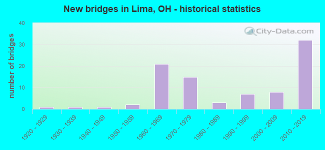
- New bridges - historical statistics
- 11920-1929
- 11930-1939
- 11940-1949
- 21950-1959
- 211960-1969
- 151970-1979
- 31980-1989
- 71990-1999
- 82000-2009
- 322010-2019
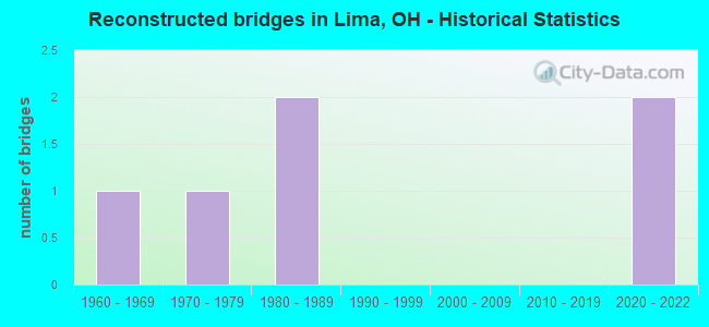
- Reconstructed bridges - Historical Statistics
- 11960-1969
- 11970-1979
- 21980-1989
- 01990-1999
- 02000-2009
- 02010-2019
- 22020-2022
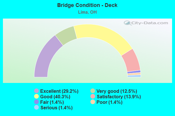
- Bridge Condition - Deck
- 29.2%Excellent
- 12.5%Very good
- 40.3%Good
- 13.9%Satisfactory
- 1.4%Fair
- 1.4%Poor
- 1.4%Serious
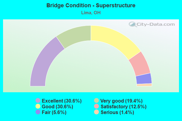
- Bridge Condition - Superstructure
- 30.6%Excellent
- 19.4%Very good
- 30.6%Good
- 12.5%Satisfactory
- 5.6%Fair
- 1.4%Serious
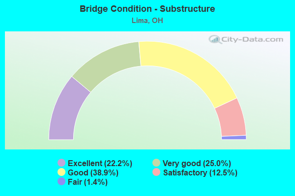
- Bridge Condition - Substructure
- 22.2%Excellent
- 25.0%Very good
- 38.9%Good
- 12.5%Satisfactory
- 1.4%Fair
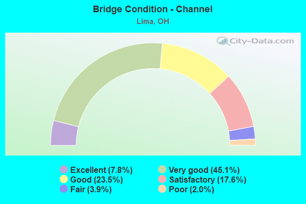
- Bridge Condition - Channel
- 7.8%Excellent
- 45.1%Very good
- 23.5%Good
- 17.6%Satisfactory
- 3.9%Fair
- 2.0%Poor
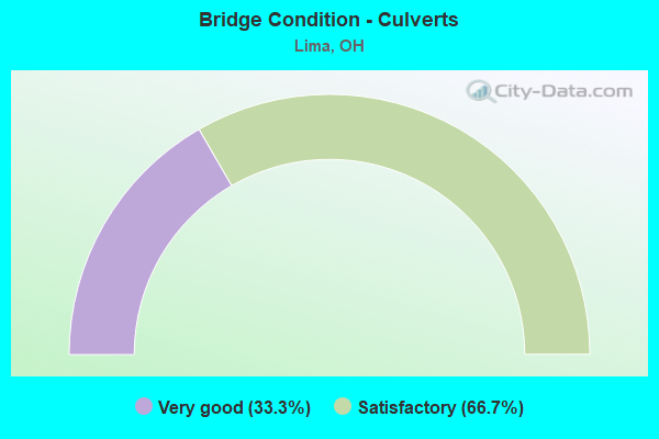
- Bridge Condition - Culverts
- 33.3%Very good
- 66.7%Satisfactory
Find on map >> Show street view
Structure Number: 201723, Location: 1.16 Mi N of Breese Rd (Lat: 40.698411, Lng: -84.108231), Route carried "under" structure: Interstate 75, Year Built: 2015, Structure Length: 0. m, Average Daily Traffic: 36,366 (year 2016), Truck Traffic: 35%, Features Intersected: TWP RD 13 MCCLAIN RD, Facility Carried by Structure: TR 13 McCLAIN RD
Minimum Vertical Clearance: 6.46m (21.19ft), Kilometerpoint: 5.279, Lanes on structure: 2, Lanes under structure: 4, Material/Design: Prestressed concrete continuous, Design/Construction: Stringer/Multi-beam, Length of Maximum Span: 38.1m (125.0ft)
Find on map >> Show street view
Structure Number: 201812, Location: 2.11 Mi N of Breese Rd (Lat: 40.699081, Lng: -84.090250), Route carried "under" structure: State highway 65, Year Built: 2015, Structure Length: 0. m, Average Daily Traffic: 4,582 (year 2015), Truck Traffic: 10%, Features Intersected: IR-75, Facility Carried by Structure: IR 75 SB
Minimum Vertical Clearance: 5.33m (17.49ft), Kilometerpoint: 6.116, Lanes on structure: 2, Lanes under structure: 4, Material/Design: Prestressed concrete continuous, Design/Construction: Stringer/Multi-beam, Length of Maximum Span: 28.0m (91.9ft)
Find on map >> Show street view
Structure Number: 20182, Location: 2.11 Mi N of Breese Rd. (Lat: 40.698831, Lng: -84.090261), Route carried "under" structure: State highway 65, Year Built: 2016, Structure Length: 0. m, Average Daily Traffic: 4,582 (year 2015), Truck Traffic: 10%, Features Intersected: IR-75, Facility Carried by Structure: IR 75 NB
Minimum Vertical Clearance: 5.21m (17.09ft), Kilometerpoint: 6.116, Lanes on structure: 2, Lanes under structure: 4, Material/Design: Prestressed concrete continuous, Design/Construction: Stringer/Multi-beam, Length of Maximum Span: 28.0m (91.9ft)
Find on map >> Show street view
Structure Number: 201936, Location: .85 Mi N of Sr 65 (Lat: 40.702250, Lng: -84.075719), Route carried "under" structure: Interstate 75, Year Built: 2015, Structure Length: 0. m, Average Daily Traffic: 36,343 (year 2016), Truck Traffic: 34%, Features Intersected: CR 196 HANTHORN RD, Facility Carried by Structure: CR 196 HANTHORN RD
Minimum Vertical Clearance: 5.91m (19.39ft), Kilometerpoint: 8.175, Lanes on structure: 2, Lanes under structure: 4, Material/Design: Prestressed concrete continuous, Design/Construction: Stringer/Multi-beam, Length of Maximum Span: 38.1m (125.0ft)
Find on map >> Show street view
Structure Number: 20196, Location: ONE MILE SOUTH OF SR 309 (Lat: 40.717069, Lng: -84.075569), Route carried "under" structure: Interstate 75, Year Built: 2012, Structure Length: 0. m, Average Daily Traffic: 36,343 (year 2016), Truck Traffic: 34%, Features Intersected: TR 192 E 4TH ST, Facility Carried by Structure: TR 192 E 4TH ST
Minimum Vertical Clearance: 5.21m (17.09ft), Kilometerpoint: 9.762, Lanes on structure: 2, Lanes under structure: 6, Material/Design: Prestressed concrete continuous, Design/Construction: Stringer/Multi-beam, Length of Maximum Span: 39.6m (129.9ft)
Find on map >> Show street view
Structure Number: 202037, Location: .92 MI N OF 4TH STREET (Lat: 40.730450, Lng: -84.075669), Route carried "under" structure: State highway 117, Year Built: 2013, Structure Length: 0. m, Average Daily Traffic: 21,540 (year 2015), Truck Traffic: 6%, Features Intersected: INTERSTATE 75, Facility Carried by Structure: IR 75 SB
Minimum Vertical Clearance: 5.18m (16.99ft), Kilometerpoint: 29.773, Lanes on structure: 2, Lanes under structure: 7, Material/Design: Prestressed concrete, Design/Construction: Stringer/Multi-beam, Length of Maximum Span: 36.9m (121.1ft)
Find on map >> Show street view
Structure Number: 202053, Location: .92 MI N OF 4TH STREET (Lat: 40.730461, Lng: -84.075350), Route carried "under" structure: State highway 117, Year Built: 2013, Structure Length: 0. m, Average Daily Traffic: 21,540 (year 2015), Truck Traffic: 6%, Features Intersected: INTERSTATE-75, Facility Carried by Structure: IR 75 NB
Minimum Vertical Clearance: 5.18m (16.99ft), Kilometerpoint: 29.773, Lanes on structure: 2, Lanes under structure: 7, Material/Design: Prestressed concrete, Design/Construction: Stringer/Multi-beam, Length of Maximum Span: 36.9m (121.1ft)
Find on map >> Show street view
Structure Number: 202177, Location: 1MILE NORTH 0F SR. 309 (Lat: 40.742369, Lng: -84.075839), Route carried "under" structure: Interstate 75, Year Built: 2012, Structure Length: 0. m, Average Daily Traffic: 38,482 (year 2016), Truck Traffic: 34%, Features Intersected: CR190 RESERVOIR RD, Facility Carried by Structure: CR190 RESERVOIR RD
Minimum Vertical Clearance: 5.21m (17.09ft), Kilometerpoint: 12.572, Lanes on structure: 3, Lanes under structure: 4, Material/Design: Prestressed concrete continuous, Design/Construction: Stringer/Multi-beam, Length of Maximum Span: 26.8m (87.9ft)
Find on map >> Show street view
Structure Number: 202266, Location: 0.43 Mile N. Ottawa River (Lat: 40.755711, Lng: -84.075739), Route carried "under" structure: State highway 81, Year Built: 2014, Structure Length: 0. m, Average Daily Traffic: 13,666 (year 2015), Truck Traffic: 10%, Features Intersected: IR 75, Facility Carried by Structure: IR 75 SB
Minimum Vertical Clearance: 5.88m (19.29ft), Kilometerpoint: 30.368, Lanes on structure: 2, Lanes under structure: 6, Material/Design: Prestressed concrete, Design/Construction: Stringer/Multi-beam, Length of Maximum Span: 38.4m (126.0ft)
Find on map >> Show street view
Structure Number: 202274, Location: 0.43 mile N. Ottawa River (Lat: 40.755761, Lng: -84.075439), Route carried "under" structure: State highway 81, Year Built: 2014, Structure Length: 0. m, Average Daily Traffic: 13,666 (year 2015), Truck Traffic: 10%, Features Intersected: IR-75, Facility Carried by Structure: IR 75 NB
Minimum Vertical Clearance: 5.27m (17.29ft), Kilometerpoint: 30.368, Lanes on structure: 2, Lanes under structure: 6, Material/Design: Prestressed concrete, Design/Construction: Stringer/Multi-beam, Length of Maximum Span: 38.4m (126.0ft)
Find on map >> Show street view
Structure Number: 202282, Location: 1.1 mi. North of SR81 (Lat: 40.770400, Lng: -84.070561), Route carried "under" structure: Interstate 75, Year Built: 1966, Structure Length: 0. m, Average Daily Traffic: 33,459 (year 2016), Truck Traffic: 38%, Features Intersected: CR 162 STEWART RD, Facility Carried by Structure: CR 162 STEWART RD
Minimum Vertical Clearance: 6.40m (21.00ft), Kilometerpoint: 15.933, Lanes on structure: 2, Lanes under structure: 4, Material/Design: Steel continuous, Design/Construction: Stringer/Multi-beam, Length of Maximum Span: 24.7m (81.0ft)
Find on map >> Show street view
Structure Number: 202312, Location: 1.5 mi. North of SR 81 (Lat: 40.774539, Lng: -84.066039), Route carried "under" structure: Interstate 75, Year Built: 1965, Structure Length: 0. m, Average Daily Traffic: 33,459 (year 2016), Truck Traffic: 38%, Features Intersected: CR 110 BIBLE RD, Facility Carried by Structure: CR 110 BIBLE RD
Minimum Vertical Clearance: 6.40m (21.00ft), Kilometerpoint: 16.510, Lanes on structure: 2, Lanes under structure: 4, Material/Design: Steel continuous, Design/Construction: Stringer/Multi-beam, Length of Maximum Span: 28.7m (94.2ft)
Find on map >> Show street view
Structure Number: 202347, Location: 4.3 mi. South of USR 30 (Lat: 40.783111, Lng: -84.051300), Route carried "under" structure: Interstate 75, Year Built: 1966, Structure Length: 0. m, Average Daily Traffic: 33,459 (year 2016), Truck Traffic: 38%, Features Intersected: CR 165 SLABTOWN RD, Facility Carried by Structure: CR 165 SLABTOWN RD
Minimum Vertical Clearance: 6.40m (21.00ft), Kilometerpoint: 19.151, Lanes on structure: 2, Lanes under structure: 4, Material/Design: Steel continuous, Design/Construction: Stringer/Multi-beam, Length of Maximum Span: 25.9m (85.0ft)
Find on map >> Show street view
Structure Number: 202371, Location: 3.8 mi. South of USR 30 (Lat: 40.789061, Lng: -84.044019), Route carried "under" structure: Interstate 75, Year Built: 1965, Structure Length: 0. m, Average Daily Traffic: 33,516 (year 2016), Truck Traffic: 36%, Features Intersected: CR 106 BLUELICK RD, Facility Carried by Structure: CR 106 BLUELICK RD
Minimum Vertical Clearance: 6.71m (22.01ft), Kilometerpoint: 18.976, Lanes on structure: 2, Lanes under structure: 4, Material/Design: Steel continuous, Design/Construction: Stringer/Multi-beam, Length of Maximum Span: 28.7m (94.2ft)
Find on map >> Show street view
Structure Number: 203637, Location: 7.76 mi. East of IR75 (Lat: 40.826831, Lng: -84.135769), Route carried "under" structure: US 30, Year Built: 1969, Structure Length: 0. m, Average Daily Traffic: 9,675 (year 2015), Truck Traffic: 43%, Features Intersected: S.R.115, Facility Carried by Structure: SR 115
Minimum Vertical Clearance: 4.62m (15.16ft), Kilometerpoint: 16.914, Lanes on structure: 2, Lanes under structure: 4, Material/Design: Steel continuous, Design/Construction: Stringer/Multi-beam, Length of Maximum Span: 25.0m (82.0ft)