Bridge Statistics for Lexington, Nebraska (NE)
Condition, Traffic, Stress, Structural Evaluation, Project Costs
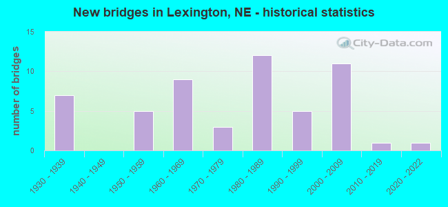
- New bridges - historical statistics
- 71930-1939
- 51950-1959
- 91960-1969
- 31970-1979
- 121980-1989
- 51990-1999
- 112000-2009
- 12010-2019
- 12020-2022
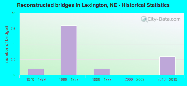
- Reconstructed bridges - Historical Statistics
- 11970-1979
- 81980-1989
- 11990-1999
- 02000-2009
- 32010-2019
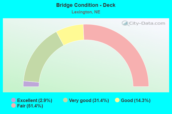
- Bridge Condition - Deck
- 2.9%Excellent
- 31.4%Very good
- 14.3%Good
- 51.4%Fair
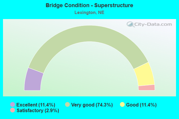
- Bridge Condition - Superstructure
- 11.4%Excellent
- 74.3%Very good
- 11.4%Good
- 2.9%Satisfactory
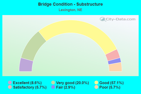
- Bridge Condition - Substructure
- 8.6%Excellent
- 20.0%Very good
- 57.1%Good
- 5.7%Satisfactory
- 2.9%Fair
- 5.7%Poor
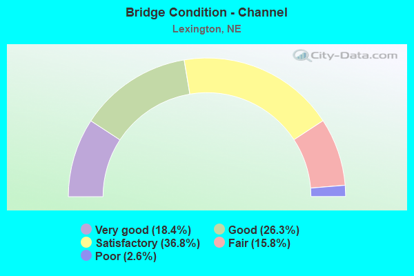
- Bridge Condition - Channel
- 18.4%Very good
- 26.3%Good
- 36.8%Satisfactory
- 15.8%Fair
- 2.6%Poor
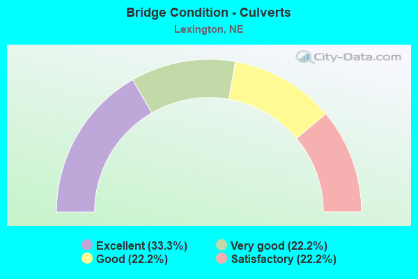
- Bridge Condition - Culverts
- 33.3%Excellent
- 22.2%Very good
- 22.2%Good
- 22.2%Satisfactory
Find on map >> Show street view
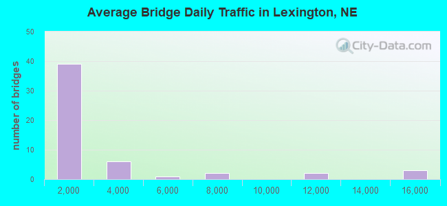
Structure Number: U14152811, Location: .5N US30 & RD 435 (Lat: 40.772200, Lng: -99.710800), Route carried "on" structure: City street 10, Year Built: 2008, Status: Open, Structure Length: 1.16m (3.81ft), Average Daily Traffic: 100 (year 2008), Average Future Daily Traffic: 110 (year 2033), Features Intersected: SPRING CREEK, Facility Carried by Structure: RD 435
Minimum Vertical Clearance: 30+ m (98+ ft), Kilometerpoint: 0.000, Lanes on structure: 2, Owner: City or Municipal Highway Agency, Approaching Roadway Width: 8.5m (27.9ft), Material/Design: Concrete, Design/Construction: Culvert, Number Of Spans In Main Unit: 3, Length of Maximum Span: 3.7m (12.1ft)
Condition: Channel: Very good, Culverts: Excellent, Operating Rating: 33.0 metric tons, Method Used To Determine Operating Rating: Field evaluation and documented engineering judgment, Inventory Rating: 22.0 metric tons, Method Used To Determine Inventory Rating: Field evaluation and documented engineering judgment, Structural Evaluation: Equal to present minimum criteria, Waterway Adequacy: Superior to present desirable criteria, Approach Roadway Alignment: Superior to present desirable criteria, Designated Inspection Frequency: Every 24 months, Inspection Date: May 2020
Find on map >> Show street view
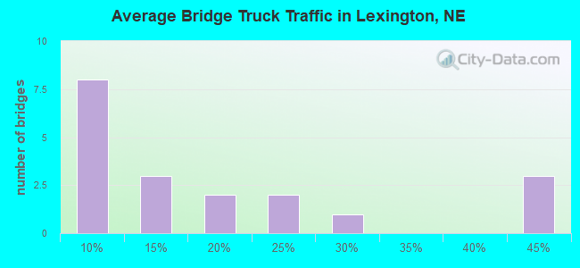
Structure Number: S080 23457, Location: 3W LEXINGTON INTRCHG (Lat: 40.754700, Lng: -99.788200), Route carried "under" structure: Interstate 80, Year Built: 1964, Structure Length: 0. m, Average Daily Traffic: 15,175 (year 2013), Truck Traffic: 44%, Features Intersected: I80, Facility Carried by Structure: COUNTY HIGHWAY
Minimum Vertical Clearance: 5.02m (16.47ft), Kilometerpoint: 37.750, Lanes on structure: 4, Lanes under structure: 4, Material/Design: Prestressed concrete, Design/Construction: Stringer/Multi-beam, Length of Maximum Span: 21.3m (69.9ft)
Find on map >> Show street view
Structure Number: S080 23722, Location: LEXINGTON INTERCHANGE (Lat: 40.742000, Lng: -99.741000), Route carried "under" structure: Interstate 80, Year Built: 1963, Structure Length: 0. m, Average Daily Traffic: 15,965 (year 2013), Truck Traffic: 43%, Features Intersected: I80, Facility Carried by Structure: US283
Minimum Vertical Clearance: 4.95m (16.24ft), Kilometerpoint: 38.177, Lanes on structure: 4, Lanes under structure: 4, Material/Design: Prestressed concrete, Design/Construction: Stringer/Multi-beam, Length of Maximum Span: 29.3m (96.1ft)
Find on map >> Show street view
Structure Number: S080 24007, Location: 3E LEXINGTON INTRCHG (Lat: 40.721700, Lng: -99.694100), Route carried "under" structure: Interstate 80, Year Built: 1963, Structure Length: 0. m, Average Daily Traffic: 15,965 (year 2013), Truck Traffic: 43%, Features Intersected: I80, Facility Carried by Structure: COUNTY HIGHWAY
Minimum Vertical Clearance: 5.08m (16.67ft), Kilometerpoint: 38.636, Lanes on structure: 4, Lanes under structure: 4, Material/Design: Prestressed concrete, Design/Construction: Stringer/Multi-beam, Length of Maximum Span: 21.3m (69.9ft)
Find on map >> Show street view
Structure Number: S283 0582, Location: US30/US283 INTRCHG (Lat: 40.775400, Lng: -99.739100), Route carried "under" structure: US 30, Year Built: 1971, Structure Length: 0. m, Average Daily Traffic: 4,540 (year 2013), Truck Traffic: 8%, Features Intersected: US30/UPRR 816-899-F, Facility Carried by Structure: US283
Minimum Vertical Clearance: 4.95m (16.24ft), Kilometerpoint: 38.294, Lanes on structure: 4, Lanes under structure: 4, Material/Design: Steel continuous, Design/Construction: Stringer/Multi-beam, Length of Maximum Span: 28.3m (92.8ft)
Find on map >> Show street view
Structure Number: U14152513, Location: ADAMS & VINE LEXINGTO (Lat: 40.775800, Lng: -99.748900), Route carried "under" structure: City street 13, Year Built: 2003, Structure Length: 0. m, Average Daily Traffic: 10 (year 2005), Features Intersected: ADAMS STREET, Facility Carried by Structure: ADAMS STREET
Minimum Vertical Clearance: 5.18m (16.99ft), Kilometerpoint: 0.000, Lanes on structure: 2, Lanes under structure: 2, Material/Design: Prestressed concrete, Design/Construction: Tee Beam, Length of Maximum Span: 14.6m (47.9ft)
Find on map >> Show street view
Structure Number: U141525135, Location: ADAMS &US30 (Lat: 40.778100, Lng: -99.748900), Route carried "under" structure: US 30, Year Built: 2003, Structure Length: 0. m, Average Daily Traffic: 3,525 (year 1999), Features Intersected: US30,UPRR&IVAN, Facility Carried by Structure: LEXINGTON VIADUCT
Minimum Vertical Clearance: 6.90m (22.64ft), Kilometerpoint: 4.413, Lanes on structure: 6, Lanes under structure: 6, Material/Design: Prestressed concrete continuous, Design/Construction: Stringer/Multi-beam, Length of Maximum Span: 43.0m (141.1ft)
Find on map >> Show street view
Structure Number: U141525135, Location: ADAMS &US30 (Lat: 40.778100, Lng: -99.748900), Route carried "under" structure: City street 13, Year Built: 2003, Structure Length: 0. m, Average Daily Traffic: 10 (year 1999), Features Intersected: US30,UPRR&IVAN, Facility Carried by Structure: LEXINGTON VIADUCT
Minimum Vertical Clearance: 7.77m (25.49ft), Kilometerpoint: 0.029, Lanes on structure: 6, Lanes under structure: 6, Material/Design: Prestressed concrete continuous, Design/Construction: Stringer/Multi-beam, Length of Maximum Span: 43.0m (141.1ft)
Find on map >> Show street view
Structure Number: U141525135, Location: ADAMS &US30 (Lat: 40.778100, Lng: -99.748900), Route carried "under" structure: City street , Year Built: 2003, Structure Length: 0. m, Features Intersected: US30,UPRR&IVAN, Facility Carried by Structure: LEXINGTON VIADUCT
Minimum Vertical Clearance: 7.33m (24.05ft), Kilometerpoint: 0.000, Lanes on structure: 6, Lanes under structure: 6, Material/Design: Prestressed concrete continuous, Design/Construction: Stringer/Multi-beam, Length of Maximum Span: 43.0m (141.1ft)
Find on map >> Show street view
Structure Number: U141525135, Location: ADAMS &US30 (Lat: 40.778100, Lng: -99.748900), Route carried "under" structure: City street 6555, Year Built: 2003, Structure Length: 0. m, Average Daily Traffic: 10 (year 1998), Features Intersected: US30,UPRR&IVAN, Facility Carried by Structure: LEXINGTON VIADUCT
Minimum Vertical Clearance: 7.74m (25.39ft), Kilometerpoint: 0.023, Lanes on structure: 2, Lanes under structure: 6, Material/Design: Prestressed concrete continuous, Design/Construction: Stringer/Multi-beam, Length of Maximum Span: 43.0m (141.1ft)
Find on map >> Show street view
Structure Number: U141527115, Location: MADISON & UPRR LEXING (Lat: 40.776400, Lng: -99.744200), Route carried "under" structure: Other road 13, Year Built: 2003, Structure Length: 0. m, Average Daily Traffic: 10 (year 2003), Features Intersected: UPRR, Facility Carried by Structure: PEDESTRIAN OVRPAS
Minimum Vertical Clearance: 8.83m (28.97ft), Kilometerpoint: 0.000, Lanes on structure: 2, Lanes under structure: 2, Material/Design: Steel, Design/Construction: Truss - Thru, Length of Maximum Span: 59.4m (194.9ft)