Bridge Statistics for Lewiston, New York (NY)
Condition, Traffic, Stress, Structural Evaluation, Project Costs
- National Bridge Inventory (NBI) Statistics
- 29Number of bridges
- 440ft / 134mTotal length
- $159,717,000Total costs
- 211,956Total average daily traffic
- 13,956Total average daily truck traffic
- National Bridge Inventory (NBI) Registered Bridges for Lewiston
- No street view available for this location
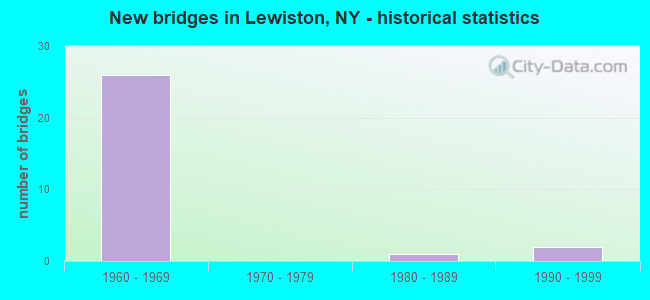
- New bridges - historical statistics
- 261960-1969
- 11980-1989
- 21990-1999

- Reconstructed bridges - Historical Statistics
- 51980-1989
- 01990-1999
- 12000-2009
- 12010-2019


- Bridge Condition - Deck
- 42.9%Very good
- 35.7%Good
- 21.4%Satisfactory

- Bridge Condition - Superstructure
- 7.1%Excellent
- 7.1%Very good
- 28.6%Good
- 35.7%Satisfactory
- 21.4%Fair

- Bridge Condition - Substructure
- 14.3%Very good
- 35.7%Good
- 42.9%Satisfactory
- 7.1%Poor

- Bridge Condition - Channel
- 25.0%Excellent
- 25.0%Good
- 25.0%Satisfactory
- 25.0%Fair

- Bridge Condition - Culverts
- 50.0%Good
- 50.0%Fair
Find on map >> Show street view
Structure Number: 101461, Location: JCT RTS 18 + 104 (Lat: 43.168297, Lng: -79.030242), Route carried "on" structure: State highway 104, Year Built: 1965, Status: Open, Structure Length: 1.22m (4.00ft), Average Daily Traffic: 10,693 (year 2018), Truck Traffic: 4%, Average Future Daily Traffic: 10,743 (year 2040), Design Load: HS 20, Features Intersected: RTE 18
Minimum Vertical Clearance: 30+ m (98+ ft), Kilometerpoint: 9.895, Lanes on structure: 4, Lanes under structure: 1, Base Highway Network: Yes, Owner: State Highway Agency, Approaching Roadway Width: 15.8m (51.8ft), Skew: 25 degrees, Material/Design: Prestressed concrete, Design/Construction: Box Beam or Girders - Multiple, Number Of Spans In Main Unit: 1, Length of Maximum Span: 11.5m (37.7ft), Curb-To-Curb Width: 22.3m (73.2ft), Out-to-Out Width: 23.2m (76.1ft)
Condition: Deck: Satisfactory, Superstructure: Good, Substructure: Satisfactory, Operating Rating: 89.8 metric tons, Method Used To Determine Operating Rating: Load Factor (LF), Inventory Rating: 79.8 metric tons, Method Used To Determine Inventory Rating: Load Factor (LF), Structural Evaluation: Equal to present minimum criteria, Deck Geometry: Superior to present desirable criteria, Underclear: Meets minimum limits, Approach Roadway Alignment: Better than present minimum criteria, Length Of Structure Improvement: 1.21m (3.97ft), Designated Inspection Frequency: Every 24 months, Inspection Date: April 2020, Bridge Improvement Cost: $2,680,000, Roadway Improvement Cost: $1,570,000, Total Project Cost: $4,250,000 ( Estimate for 2021), Wearing Surface/Protective System: Wearing Surface: Monolithic Concrete
Find on map >> Show street view
Structure Number: 1036319, Location: 1.1 MI N JCT RTS 104 & 61 (Lat: 43.150583, Lng: -79.037953), Route carried "on" structure: Ramp State highway 190, Year Built: 1962, Year Reconstructed: 1994, Status: Open, Structure Length: 4.54m (14.90ft), Average Daily Traffic: 10,524 (year 2019), Truck Traffic: 4%, Average Future Daily Traffic: 10,573 (year 2040), Design Load: HS 20, Features Intersected: RTE 104
Minimum Vertical Clearance: 30+ m (98+ ft), Kilometerpoint: 7.691, Lanes on structure: 4, Lanes under structure: 5, Base Highway Network: Yes, Owner: State Highway Agency, Approaching Roadway Width: 18.0m (59.1ft), Skew: 20 degrees, Material/Design: Steel, Design/Construction: Stringer/Multi-beam, Number Of Spans In Main Unit: 3, Length of Maximum Span: 23.4m (76.8ft), Curb-To-Curb Width: 18.6m (61.0ft), Out-to-Out Width: 20.5m (67.3ft)
Condition: Deck: Very good, Superstructure: Fair, Substructure: Poor, Operating Rating: 39.5 metric tons, Method Used To Determine Operating Rating: Load and Resistance Factor Rating (LRFR) rating reported by rating factor(RF) method using HL-93 loadings, Inventory Rating: 30.5 metric tons, Method Used To Determine Inventory Rating: Load and Resistance Factor Rating (LRFR) rating reported by rating factor(RF) method using HL-93 loadings, Structural Evaluation: Meets minimum limits, Deck Geometry: Superior to present desirable criteria, Underclear: High priority of corrective action, Approach Roadway Alignment: Equal to present desirable criteria, Length Of Structure Improvement: 4.54m (14.90ft), Designated Inspection Frequency: Every 24 months, Inspection Date: August 2021, Bridge Improvement Cost: $3,482,000, Roadway Improvement Cost: $2,039,000, Total Project Cost: $5,520,000 ( Estimate for 2021), Deck Structure Type: Concrete Cast-file-Place, Wearing Surface/Protective System: Wearing Surface: Integral Concrete, Deck Protection: Epoxy Coated Reinforcing
Find on map >> Show street view
Structure Number: 103636, Location: 0.3 MI N JCT RTS 104 & 18 (Lat: 43.170006, Lng: -79.030128), Route carried "on" structure: State highway 104, Year Built: 1965, Year Reconstructed: 1994, Status: Open, Structure Length: 8.84m (29.00ft), Average Daily Traffic: 10,693 (year 2018), Truck Traffic: 4%, Average Future Daily Traffic: 10,743 (year 2040), Design Load: HS 20, Features Intersected: RTE 957A, 957A957A540140
Minimum Vertical Clearance: 30+ m (98+ ft), Kilometerpoint: 9.960, Lanes on structure: 2, Lanes under structure: 8, Owner: State Highway Agency, Approaching Roadway Width: 8.5m (27.9ft), Skew: 5 degrees, Material/Design: Steel continuous, Design/Construction: Stringer/Multi-beam, Number Of Spans In Main Unit: 2, Length of Maximum Span: 42.9m (140.7ft), Curb-To-Curb Width: 9.3m (30.5ft), Out-to-Out Width: 10.2m (33.5ft)
Condition: Deck: Good, Superstructure: Good, Substructure: Good, Operating Rating: 70.8 metric tons, Method Used To Determine Operating Rating: Load Factor (LF), Inventory Rating: 36.3 metric tons, Method Used To Determine Inventory Rating: Load Factor (LF), Structural Evaluation: Better than present minimum criteria, Deck Geometry: Meets minimum limits, Underclear: Meets minimum limits, Approach Roadway Alignment: Equal to present desirable criteria, Length Of Structure Improvement: 8.83m (28.97ft), Designated Inspection Frequency: Every 24 months, Inspection Date: September 2021, Bridge Improvement Cost: $3,803,000, Roadway Improvement Cost: $2,227,000, Total Project Cost: $6,030,000 ( Estimate for 2021), Deck Structure Type: Concrete Cast-file-Place, Wearing Surface/Protective System: Wearing Surface: Integral Concrete, Deck Protection: Epoxy Coated Reinforcing
Find on map >> Show street view
Structure Number: 104389, Location: 1.9 MI N JCT RTS 265 + 31 (Lat: 43.143936, Lng: -79.022103), Route carried "on" structure: State highway 265, Year Built: 1963, Year Reconstructed: 2015, Status: Open, Structure Length: 24.93m (81.79ft), Average Daily Traffic: 6,804 (year 2020), Truck Traffic: 5%, Average Future Daily Traffic: 7,185 (year 2040), Design Load: HL 93, Features Intersected: POWER RESERVOIR
Minimum Vertical Clearance: 30+ m (98+ ft), Kilometerpoint: 18.697, Lanes on structure: 2, Base Highway Network: Yes, Owner: State Highway Agency, Approaching Roadway Width: 10.1m (33.1ft), Material/Design: Steel continuous, Design/Construction: Stringer/Multi-beam, Number Of Spans In Main Unit: 12, Length of Maximum Span: 20.7m (67.9ft), Curb-To-Curb Width: 10.0m (32.8ft), Out-to-Out Width: 11.0m (36.1ft)
Condition: Deck: Very good, Superstructure: Excellent, Substructure: Satisfactory, Channel: Excellent, Operating Rating: 97.1 metric tons, Method Used To Determine Operating Rating: Load Testing, Inventory Rating: 58.1 metric tons, Method Used To Determine Inventory Rating: Load Testing, Structural Evaluation: Equal to present minimum criteria, Deck Geometry: Meets minimum limits, Waterway Adequacy: Equal to present desirable criteria, Approach Roadway Alignment: Equal to present desirable criteria, Length Of Structure Improvement: 24.93m (81.79ft), Designated Inspection Frequency: Every 24 months, Underwater Inspection Frequency: Every 60 months, Inspection Date: November 2021, Underwater Inspection Date: January 2021, Bridge Improvement Cost: $12,890,000, Roadway Improvement Cost: $7,548,000, Total Project Cost: $20,438,000 ( Estimate for 2021), Deck Structure Type: Concrete Cast-file-Place, Wearing Surface/Protective System: Wearing Surface: Integral Concrete, Deck Protection: Epoxy Coated Reinforcing
Find on map >> Show street view
Structure Number: 106004, Location: JCT RTES 104 + 18 (Lat: 43.173472, Lng: -79.017672), Route carried "on" structure: State highway 104, Year Built: 1992, Status: Open, Structure Length: 3.29m (10.79ft), Average Daily Traffic: 4,913 (year 2020), Truck Traffic: 16%, Average Future Daily Traffic: 5,188 (year 2040), Design Load: HS 20, Features Intersected: RTE 18
Minimum Vertical Clearance: 30+ m (98+ ft), Kilometerpoint: 11.537, Lanes on structure: 2, Lanes under structure: 2, Base Highway Network: Yes, Owner: State Highway Agency, Approaching Roadway Width: 13.4m (44.0ft), Material/Design: Prestressed concrete, Design/Construction: Box Beam or Girders - Multiple, Number Of Spans In Main Unit: 1, Length of Maximum Span: 32.0m (105.0ft), Curb-To-Curb Width: 13.1m (43.0ft), Out-to-Out Width: 14.0m (45.9ft)
Condition: Deck: Good, Superstructure: Good, Substructure: Very good, Operating Rating: 89.8 metric tons, Method Used To Determine Operating Rating: Load Factor (LF), Inventory Rating: 34.5 metric tons, Method Used To Determine Inventory Rating: Load Factor (LF), Structural Evaluation: Better than present minimum criteria, Deck Geometry: Equal to present minimum criteria, Underclear: Meets minimum limits, Approach Roadway Alignment: Equal to present desirable criteria, Length Of Structure Improvement: 3.29m (10.79ft), Designated Inspection Frequency: Every 24 months, Inspection Date: August 2020, Bridge Improvement Cost: $1,168,000, Roadway Improvement Cost: $684,000, Total Project Cost: $1,853,000 ( Estimate for 2021), Deck Structure Type: Concrete Cast-file-Place, Wearing Surface/Protective System: Wearing Surface: Monolithic Concrete, Deck Protection: Epoxy Coated Reinforcing
Find on map >> Show street view
Structure Number: 106007, Location: JCT RTS 104 + 18F (Lat: 43.172806, Lng: -79.029019), Route carried "on" structure: State highway 104, Year Built: 1965, Status: Open, Structure Length: 6.98m (22.90ft), Average Daily Traffic: 10,693 (year 2018), Truck Traffic: 4%, Average Future Daily Traffic: 10,743 (year 2040), Features Intersected: RT104 WEST BOUND, ROBT M
Minimum Vertical Clearance: 30+ m (98+ ft), Kilometerpoint: 10.410, Lanes on structure: 5, Lanes under structure: 7, Base Highway Network: Yes, Owner: State Highway Agency, Approaching Roadway Width: 27.1m (88.9ft), Skew: 1 degrees, Material/Design: Steel, Design/Construction: Stringer/Multi-beam, Number Of Spans In Main Unit: 2, Length of Maximum Span: 35.0m (114.8ft), Curb or Sidewalk Widths: Left: 1.5m (4.9ft), Right: 1.5m (4.9ft), Curb-To-Curb Width: 19.5m (64.0ft), Out-to-Out Width: 23.1m (75.8ft)
Condition: Deck: Satisfactory, Superstructure: Good, Substructure: Good, Operating Rating: 73.5 metric tons, Method Used To Determine Operating Rating: Load Testing, Inventory Rating: 43.5 metric tons, Method Used To Determine Inventory Rating: Load Testing, Structural Evaluation: Better than present minimum criteria, Deck Geometry: Meets minimum limits, Underclear: Somewhat better than minimum adequacy, Approach Roadway Alignment: Equal to present minimum criteria, Length Of Structure Improvement: 6.97m (22.87ft), Designated Inspection Frequency: Every 24 months, Inspection Date: September 2020, Bridge Improvement Cost: $6,138,000, Roadway Improvement Cost: $3,595,000, Total Project Cost: $9,733,000 ( Estimate for 2021), Deck Structure Type: Concrete Cast-file-Place, Wearing Surface/Protective System: Wearing Surface: Integral Concrete
Find on map >> Show street view
Structure Number: 1068279, Location: AT JCT 957A ACCESS & 190I (Lat: 43.149894, Lng: -79.039489), Route carried "on" structure: Ramp State highway , Year Built: 1963, Year Reconstructed: 1994, Status: Open, Structure Length: 4.18m (13.71ft), Average Daily Traffic: 208 (year 2019), Truck Traffic: 3%, Average Future Daily Traffic: 241 (year 2040), Design Load: HS 20, Features Intersected: RTE 957A, RELIEF, Facility Carried by Structure: RAMP TO & FR.190I
Minimum Vertical Clearance: 30+ m (98+ ft), Kilometerpoint: 0.225, Lanes on structure: 2, Lanes under structure: 2, Owner: State Agenciy, Maintenance Responsibility: State Highway Agency, Approaching Roadway Width: 9.8m (32.2ft), Skew: 23 degrees, Material/Design: Steel, Design/Construction: Stringer/Multi-beam, Number Of Spans In Main Unit: 2, Length of Maximum Span: 26.2m (86.0ft), Curb-To-Curb Width: 16.0m (52.5ft), Out-to-Out Width: 17.1m (56.1ft)
Condition: Deck: Very good, Superstructure: Satisfactory, Substructure: Good, Operating Rating: 88.0 metric tons, Method Used To Determine Operating Rating: Load Factor (LF), Inventory Rating: 52.6 metric tons, Method Used To Determine Inventory Rating: Load Factor (LF), Structural Evaluation: Equal to present minimum criteria, Deck Geometry: Superior to present desirable criteria, Underclear: High priority of corrective action, Approach Roadway Alignment: Equal to present desirable criteria, Length Of Structure Improvement: 4.17m (13.68ft), Designated Inspection Frequency: Every 24 months, Inspection Date: August 2020, Bridge Improvement Cost: $4,163,000, Roadway Improvement Cost: $2,438,000, Total Project Cost: $6,601,000 ( Estimate for 2021), Deck Structure Type: Concrete Cast-file-Place, Wearing Surface/Protective System: Wearing Surface: Integral Concrete, Deck Protection: Epoxy Coated Reinforcing
Find on map >> Show street view
Structure Number: 106828, Location: .4 MI W JCT 957A & I190 (Lat: 43.150928, Lng: -79.039772), Route carried "on" structure: Ramp Other road , Year Built: 1962, Status: Open, Structure Length: 2.07m (6.79ft), Average Daily Traffic: 970 (year 2018), Truck Traffic: 4%, Average Future Daily Traffic: 1,124 (year 2040), Design Load: HS 20, Features Intersected: RELIEF, Facility Carried by Structure: RAMP 190I TO 957A
Minimum Vertical Clearance: 30+ m (98+ ft), Kilometerpoint: 0.032, Lanes on structure: 1, Owner: State Park, Forest, or Reservation Agency, Maintenance Responsibility: State Highway Agency, Approaching Roadway Width: 4.9m (16.1ft), Skew: 5 degrees, Material/Design: Steel, Design/Construction: Stringer/Multi-beam, Number Of Spans In Main Unit: 1, Length of Maximum Span: 19.2m (63.0ft), Curb-To-Curb Width: 7.7m (25.3ft), Out-to-Out Width: 8.8m (28.9ft)
Condition: Deck: Very good, Superstructure: Very good, Substructure: Good, Operating Rating: 86.2 metric tons, Method Used To Determine Operating Rating: Load Factor (LF), Inventory Rating: 51.7 metric tons, Method Used To Determine Inventory Rating: Load Factor (LF), Structural Evaluation: Better than present minimum criteria, Deck Geometry: Better than present minimum criteria, Approach Roadway Alignment: Equal to present desirable criteria, Length Of Structure Improvement: 2.07m (6.79ft), Designated Inspection Frequency: Every 24 months, Inspection Date: November 2020, Bridge Improvement Cost: $2,614,000, Roadway Improvement Cost: $1,531,000, Total Project Cost: $4,145,000 ( Estimate for 2021), Deck Structure Type: Concrete Cast-file-Place, Wearing Surface/Protective System: Wearing Surface: Integral Concrete
Find on map >> Show street view
Structure Number: 1068301, Location: .3 MI N JCT SH104 & SH18F (Lat: 43.176733, Lng: -79.028739), Route carried "on" structure: State highway 957A, Year Built: 1965, Year Reconstructed: 1994, Status: Open, Structure Length: 3.72m (12.20ft), Average Daily Traffic: 2,223 (year 2018), Truck Traffic: 1%, Average Future Daily Traffic: 2,576 (year 2040), Design Load: HS 20, Features Intersected: MOHAWK STREET
Minimum Vertical Clearance: 30+ m (98+ ft), Kilometerpoint: 17.409, Lanes on structure: 2, Lanes under structure: 2, Base Highway Network: Yes, Owner: State Park, Forest, or Reservation Agency, Maintenance Responsibility: State Highway Agency, Approaching Roadway Width: 7.3m (24.0ft), Material/Design: Steel, Design/Construction: Stringer/Multi-beam, Number Of Spans In Main Unit: 3, Length of Maximum Span: 15.8m (51.8ft), Curb-To-Curb Width: 12.9m (42.3ft), Out-to-Out Width: 13.8m (45.3ft)
Condition: Deck: Good, Superstructure: Fair, Substructure: Satisfactory, Operating Rating: 57.0 metric tons, Method Used To Determine Operating Rating: Load and Resistance Factor Rating (LRFR) rating reported by rating factor(RF) method using HL-93 loadings, Inventory Rating: 43.7 metric tons, Method Used To Determine Inventory Rating: Load and Resistance Factor Rating (LRFR) rating reported by rating factor(RF) method using HL-93 loadings, Structural Evaluation: Somewhat better than minimum adequacy, Deck Geometry: Superior to present desirable criteria, Underclear: Somewhat better than minimum adequacy, Approach Roadway Alignment: Equal to present desirable criteria, Length Of Structure Improvement: 3.71m (12.17ft), Designated Inspection Frequency: Every 24 months, Inspection Date: June 2021, Bridge Improvement Cost: $1,918,000, Roadway Improvement Cost: $1,123,000, Total Project Cost: $3,041,000 ( Estimate for 2021), Deck Structure Type: Concrete Cast-file-Place, Wearing Surface/Protective System: Wearing Surface: Integral Concrete, Deck Protection: Epoxy Coated Reinforcing
Find on map >> Show street view
Structure Number: 1068302, Location: .3 MI N JCT SH104 & SH18F (Lat: 43.176747, Lng: -79.028389), Route carried "on" structure: State highway 957A, Year Built: 1965, Year Reconstructed: 1994, Status: Open, Structure Length: 3.75m (12.30ft), Average Daily Traffic: 385 (year 2020), Truck Traffic: 4%, Average Future Daily Traffic: 446 (year 2040), Design Load: HS 20, Features Intersected: MOHAWK STREET
Minimum Vertical Clearance: 30+ m (98+ ft), Kilometerpoint: 0.451, Lanes on structure: 2, Lanes under structure: 2, Base Highway Network: Yes, Owner: State Park, Forest, or Reservation Agency, Maintenance Responsibility: State Highway Agency, Approaching Roadway Width: 11.0m (36.1ft), Material/Design: Steel, Design/Construction: Stringer/Multi-beam, Number Of Spans In Main Unit: 3, Length of Maximum Span: 16.4m (53.8ft), Curb-To-Curb Width: 16.5m (54.1ft), Out-to-Out Width: 17.4m (57.1ft)
Condition: Deck: Good, Superstructure: Fair, Substructure: Satisfactory, Operating Rating: 58.6 metric tons, Method Used To Determine Operating Rating: Load and Resistance Factor Rating (LRFR) rating reported by rating factor(RF) method using HL-93 loadings, Inventory Rating: 45.0 metric tons, Method Used To Determine Inventory Rating: Load and Resistance Factor Rating (LRFR) rating reported by rating factor(RF) method using HL-93 loadings, Structural Evaluation: Somewhat better than minimum adequacy, Deck Geometry: Superior to present desirable criteria, Underclear: Somewhat better than minimum adequacy, Approach Roadway Alignment: Equal to present desirable criteria, Length Of Structure Improvement: 3.74m (12.27ft), Designated Inspection Frequency: Every 24 months, Inspection Date: June 2021, Bridge Improvement Cost: $2,440,000, Roadway Improvement Cost: $1,429,000, Total Project Cost: $3,869,000 ( Estimate for 2021), Deck Structure Type: Concrete Cast-file-Place, Wearing Surface/Protective System: Wearing Surface: Integral Concrete, Deck Protection: Epoxy Coated Reinforcing
Find on map >> Show street view
Structure Number: 106831, Location: 2.5 MI N JCT 104 & 18F (Lat: 43.208422, Lng: -79.028864), Route carried "on" structure: Other road , Year Built: 1965, Status: Open, Structure Length: 7.28m (23.88ft), Average Daily Traffic: 2,310 (year 2017), Truck Traffic: 4%, Average Future Daily Traffic: 2,439 (year 2040), Design Load: HS 20, Features Intersected: 957A 957A 54014058, RTE, Facility Carried by Structure: PLETCHER RD
Minimum Vertical Clearance: 30+ m (98+ ft), Kilometerpoint: 1.352, Lanes on structure: 2, Lanes under structure: 5, Owner: State Park, Forest, or Reservation Agency, Maintenance Responsibility: State Highway Agency, Approaching Roadway Width: 8.8m (28.9ft), Material/Design: Steel, Design/Construction: Stringer/Multi-beam, Number Of Spans In Main Unit: 2, Length of Maximum Span: 35.6m (116.8ft), Curb-To-Curb Width: 8.5m (27.9ft), Out-to-Out Width: 10.0m (32.8ft)
Condition: Deck: Very good, Superstructure: Satisfactory, Substructure: Very good, Operating Rating: 88.9 metric tons, Method Used To Determine Operating Rating: Load Factor (LF), Inventory Rating: 51.7 metric tons, Method Used To Determine Inventory Rating: Load Factor (LF), Structural Evaluation: Equal to present minimum criteria, Deck Geometry: Meets minimum limits, Underclear: High priority of corrective action, Approach Roadway Alignment: Equal to present minimum criteria, Length Of Structure Improvement: 7.28m (23.88ft), Designated Inspection Frequency: Every 24 months, Inspection Date: May 2020, Bridge Improvement Cost: $2,822,000, Roadway Improvement Cost: $1,653,000, Total Project Cost: $4,474,000 ( Estimate for 2021), Deck Structure Type: Concrete Cast-file-Place, Wearing Surface/Protective System: Wearing Surface: Epoxy Overlay
Find on map >> Show street view
Structure Number: 1090119, Location: RAMP P AT JCT RT 104&190I (Lat: 43.151475, Lng: -79.031094), Route carried "on" structure: Ramp Interstate 190, Year Built: 1962, Year Reconstructed: 2021, Status: Open, Structure Length: 8.50m (27.89ft), Average Daily Traffic: 48,740 (year 1997), Truck Traffic: 14%, Average Future Daily Traffic: 68,236 (year 2017), Design Load: HS 20, Features Intersected: 190I190I54011065 SB, RTE
Minimum Vertical Clearance: 32.69m (107.25ft), Kilometerpoint: 0.531, Lanes on structure: 4, Lanes under structure: 6, Base Highway Network: Yes, Owner: State Highway Agency, Approaching Roadway Width: 9.1m (29.9ft), Skew: 23 degrees, Material/Design: Steel, Design/Construction: Stringer/Multi-beam, Number Of Spans In Main Unit: 4, Length of Maximum Span: 26.2m (86.0ft), Curb-To-Curb Width: 17.9m (58.7ft), Out-to-Out Width: 19.3m (63.3ft)
Condition: Deck: Satisfactory, Superstructure: Satisfactory, Substructure: Satisfactory, Operating Rating: 95.3 metric tons, Method Used To Determine Operating Rating: Load Factor (LF), Inventory Rating: 57.2 metric tons, Method Used To Determine Inventory Rating: Load Factor (LF), Structural Evaluation: Equal to present minimum criteria, Deck Geometry: Better than present minimum criteria, Underclear: High priority of corrective action, Approach Roadway Alignment: Equal to present desirable criteria, Length Of Structure Improvement: 8.50m (27.89ft), Designated Inspection Frequency: Every 24 months, Inspection Date: September 2021, Bridge Improvement Cost: $5,910,000, Roadway Improvement Cost: $3,461,000, Total Project Cost: $9,370,000 ( Estimate for 2021), Deck Structure Type: Concrete Cast-file-Place, Wearing Surface/Protective System: Wearing Surface: Integral Concrete, Deck Protection: Epoxy Coated Reinforcing
Find on map >> Show street view
Structure Number: 225764, Location: 2.5 MI N OF LEWISTON (Lat: 43.209125, Lng: -79.026511), Route carried "on" structure: Other road , Year Built: 1965, Status: Open, Structure Length: 0.70m (2.30ft), Average Daily Traffic: 2,310 (year 2017), Truck Traffic: 4%, Average Future Daily Traffic: 2,439 (year 2040), Design Load: HS 20, Features Intersected: FOURMILE CREEK, Facility Carried by Structure: PLETCHER ROAD
Minimum Vertical Clearance: 30+ m (98+ ft), Kilometerpoint: 1.529, Lanes on structure: 2, Owner: Town or Township Highway Agency, Approaching Roadway Width: 8.5m (27.9ft), Material/Design: Concrete continuous, Design/Construction: Culvert, Number Of Spans In Main Unit: 2, Length of Maximum Span: 3.3m (10.8ft)
Condition: Channel: Satisfactory, Culverts: Good, Operating Rating: 92.5 metric tons, Method Used To Determine Operating Rating: Load Factor (LF), Inventory Rating: 55.3 metric tons, Method Used To Determine Inventory Rating: Load Factor (LF), Structural Evaluation: Better than present minimum criteria, Waterway Adequacy: Equal to present minimum criteria, Approach Roadway Alignment: Equal to present minimum criteria, Length Of Structure Improvement: 0.70m (2.30ft), Designated Inspection Frequency: Every 24 months, Inspection Date: September 2020, Bridge Improvement Cost: $165,000, Roadway Improvement Cost: $97,000, Total Project Cost: $262,000 ( Estimate for 2021), Wearing Surface/Protective System: Wearing Surface: Bituminous
Find on map >> Show street view
Structure Number: 336802, Location: .8 MI W JCT SH104 & SH265 (Lat: 43.158064, Lng: -79.023300), Route carried "on" structure: Other road , Year Built: 1989, Status: Open, Structure Length: 1.07m (3.51ft), Average Daily Traffic: 166 (year 2020), Truck Traffic: 4%, Average Future Daily Traffic: 232 (year 2040), Design Load: HS 20, Features Intersected: FISH CREEK, Facility Carried by Structure: COUNTRY CLB TRAIL
Minimum Vertical Clearance: 4.39m (14.40ft), Kilometerpoint: 0.306, Lanes on structure: 2, Owner: Town or Township Highway Agency, Approaching Roadway Width: 9.1m (29.9ft), Material/Design: Concrete, Design/Construction: Culvert, Number Of Spans In Main Unit: 3, Length of Maximum Span: 3.0m (9.8ft), Curb-To-Curb Width: 9.2m (30.2ft), Out-to-Out Width: 10.7m (35.1ft)
Condition: Channel: Fair, Culverts: Fair, Operating Rating: 70.8 metric tons, Method Used To Determine Operating Rating: Load Factor (LF), Inventory Rating: 42.6 metric tons, Method Used To Determine Inventory Rating: Load Factor (LF), Structural Evaluation: Somewhat better than minimum adequacy, Deck Geometry: High priority of corrective action, Waterway Adequacy: Somewhat better than minimum adequacy, Approach Roadway Alignment: Equal to present desirable criteria, Length Of Structure Improvement: 1.06m (3.48ft), Designated Inspection Frequency: Every 24 months, Inspection Date: November 2020, Bridge Improvement Cost: $314,000, Roadway Improvement Cost: $184,000, Total Project Cost: $499,000 ( Estimate for 2021)
Find on map >> Show street view
Structure Number: 5036329, Location: JCT RT 104 + I-190 (Lat: 43.152294, Lng: -79.038361), Route carried "on" structure: Interstate 190, Year Built: 1962, Status: Open, Structure Length: 4.79m (15.72ft), Average Daily Traffic: 13,480 (year 2019), Truck Traffic: 4%, Average Future Daily Traffic: 13,614 (year 2039), Design Load: HS 20, Features Intersected: RTE 104
Minimum Vertical Clearance: 4.90m (16.08ft), Kilometerpoint: 7.868, Lanes on structure: 8, Lanes under structure: 4, Base Highway Network: Yes, Toll: Toll bridge, Owner: Local Toll Authority, Approaching Roadway Width: 32.7m (107.3ft), Skew: 1 degrees, Material/Design: Steel, Design/Construction: Stringer/Multi-beam, Number Of Spans In Main Unit: 3, Length of Maximum Span: 25.2m (82.7ft), Curb-To-Curb Width: 32.7m (107.3ft), Out-to-Out Width: 33.6m (110.2ft)
Condition: Deck: Very good, Superstructure: Satisfactory, Substructure: Good, Operating Rating: 40.2 metric tons, Method Used To Determine Operating Rating: Load and Resistance Factor Rating (LRFR) rating reported by rating factor(RF) method using HL-93 loadings, Inventory Rating: 30.8 metric tons, Method Used To Determine Inventory Rating: Load and Resistance Factor Rating (LRFR) rating reported by rating factor(RF) method using HL-93 loadings, Structural Evaluation: Equal to present minimum criteria, Deck Geometry: Somewhat better than minimum adequacy, Underclear: High priority of corrective action, Approach Roadway Alignment: Equal to present minimum criteria, Length Of Structure Improvement: 4.78m (15.68ft), Designated Inspection Frequency: Every 24 months, Inspection Date: July 2020, Bridge Improvement Cost: $5,933,000, Roadway Improvement Cost: $3,474,000, Total Project Cost: $9,407,000 ( Estimate for 2021), Deck Structure Type: Concrete Cast-file-Place, Wearing Surface/Protective System: Wearing Surface: Integral Concrete
Find on map >> Show street view
Structure Number: 5068299, Location: AT I190 & INT 104 (Lat: 43.152758, Lng: -79.041881), Route carried "on" structure: Other road 190, Year Built: 1960, Year Reconstructed: 2005, Status: Open, Structure Length: 48.59m (159.42ft), Average Daily Traffic: 10,607 (year 2020), Truck Traffic: 29%, Average Future Daily Traffic: 11,887 (year 2040), Design Load: HS 20+Mod, Features Intersected: Niagara Parkway, NIAGARA
Minimum Vertical Clearance: 4.87m (15.98ft), Kilometerpoint: 11.794, Lanes on structure: 5, Lanes under structure: 6, Base Highway Network: Yes, Toll: Toll bridge, Owner: Local Toll Authority, Approaching Roadway Width: 29.3m (96.1ft), Skew: 1 degrees, Navigation Control: Yes ( Vertical Clearance: 93.5m (306.8ft), Horizontal Clearance: 129.2m (423.9ft)), Material/Design: Steel, Design/Construction: Arch - Deck, Number Of Spans In Main Unit: 1, Number Of Approach Spans: 7, Length of Maximum Span: 315.4m (1,034.8ft), Curb-To-Curb Width: 18.3m (60.0ft), Out-to-Out Width: 20.3m (66.6ft)
Condition: Deck: Good, Superstructure: Satisfactory, Substructure: Satisfactory, Channel: Good, Operating Rating: 72.9 metric tons, Method Used To Determine Operating Rating: Field evaluation and documented engineering judgment, Inventory Rating: 32.7 metric tons, Method Used To Determine Inventory Rating: Field evaluation and documented engineering judgment, Structural Evaluation: Equal to present minimum criteria, Deck Geometry: High priority of replacement, Underclear: High priority of corrective action, Waterway Adequacy: Superior to present desirable criteria, Approach Roadway Alignment: Equal to present desirable criteria, Length Of Structure Improvement: 48.58m (159.38ft), Designated Inspection Frequency: Every 24 months, Critical Feature Inspection Frequency: Every 24 months, Inspection Date: May 2021, Critical Feature Inspection Date: May 2021, Bridge Improvement Cost: $44,289,000, Roadway Improvement Cost: $25,936,000, Total Project Cost: $70,225,000 ( Estimate for 2021), Deck Structure Type: Concrete Cast-file-Place, Wearing Surface/Protective System: Wearing Surface: Bituminous, Membrane: Other, Deck Protection: Galvanized Reinforcing
Find on map >> Show street view
Structure Number: 101461, Location: JCT RTS 18 + 104 (Lat: 43.168297, Lng: -79.030242), Route carried "under" structure: State highway 18, Year Built: 1965, Structure Length: 0. m, Average Daily Traffic: 5,641 (year 2000), Features Intersected: RTE 18, Facility Carried by Structure: RTE 104
Minimum Vertical Clearance: 4.55m (14.93ft), Kilometerpoint: 0.756, Lanes on structure: 4, Lanes under structure: 1, Material/Design: Prestressed concrete, Design/Construction: Box Beam or Girders - Multiple, Length of Maximum Span: 11.5m (37.7ft)
Find on map >> Show street view
Structure Number: 1036319, Location: 1.1 MI N JCT RTS 104 & 61 (Lat: 43.150583, Lng: -79.037953), Route carried "under" structure: US 104, Year Built: 1962, Structure Length: 0. m, Average Daily Traffic: 6,580 (year 2002), Features Intersected: RTE 104, Facility Carried by Structure: RTE I190
Minimum Vertical Clearance: 5.28m (17.32ft), Kilometerpoint: 2.301, Lanes on structure: 4, Lanes under structure: 5, Material/Design: Steel, Design/Construction: Stringer/Multi-beam, Length of Maximum Span: 23.4m (76.8ft)
Find on map >> Show street view
Structure Number: 103636, Location: 0.3 MI N JCT RTS 104 & 18 (Lat: 43.170006, Lng: -79.030128), Route carried "under" structure: Other road 957A, Year Built: 1965, Structure Length: 0. m, Average Daily Traffic: 7,280 (year 2002), Features Intersected: RTE 957A, 957A957A540140, Facility Carried by Structure: RTE 104
Minimum Vertical Clearance: 4.87m (15.98ft), Kilometerpoint: 5.374, Lanes on structure: 2, Lanes under structure: 4, Material/Design: Steel continuous, Design/Construction: Stringer/Multi-beam, Length of Maximum Span: 42.9m (140.7ft)
Find on map >> Show street view
Structure Number: 103636, Location: 0.3 MI N JCT RTS 104 & 18 (Lat: 43.170006, Lng: -79.030128), Route carried "under" structure: Other road , Year Built: 1965, Structure Length: 0. m, Average Daily Traffic: 6,550 (year 1990), Features Intersected: RTE 957A, 957A957A540140, Facility Carried by Structure: RTE 104
Minimum Vertical Clearance: 4.87m (15.98ft), Kilometerpoint: 5.374, Lanes on structure: 2, Lanes under structure: 4, Material/Design: Steel continuous, Design/Construction: Stringer/Multi-beam, Length of Maximum Span: 42.9m (140.7ft)
Find on map >> Show street view
Structure Number: 106004, Location: JCT RTES 104 + 18 (Lat: 43.173472, Lng: -79.017672), Route carried "under" structure: State highway 18, Year Built: 1992, Structure Length: 0. m, Average Daily Traffic: 5,296 (year 2000), Features Intersected: RTE 18, Facility Carried by Structure: RTE 104
Minimum Vertical Clearance: 4.62m (15.16ft), Kilometerpoint: 1.657, Lanes on structure: 2, Lanes under structure: 2, Material/Design: Prestressed concrete, Design/Construction: Box Beam or Girders - Multiple, Length of Maximum Span: 32.0m (105.0ft)
Find on map >> Show street view
Structure Number: 106007, Location: JCT RTS 104 + 18F (Lat: 43.172806, Lng: -79.029019), Route carried "under" structure: State highway , Year Built: 1965, Structure Length: 0. m, Average Daily Traffic: 5,250 (year 1979), Features Intersected: RT104 WEST BOUND, ROBT M, Facility Carried by Structure: RTE 104
Minimum Vertical Clearance: 4.50m (14.76ft), Kilometerpoint: 5.149, Lanes on structure: 5, Lanes under structure: 2, Material/Design: Steel, Design/Construction: Stringer/Multi-beam, Length of Maximum Span: 35.0m (114.8ft)
Find on map >> Show street view
Structure Number: 1068279, Location: AT JCT 957A ACCESS & 190I (Lat: 43.149894, Lng: -79.039489), Route carried "under" structure: State highway 957A, Year Built: 1963, Structure Length: 0. m, Average Daily Traffic: 8,483 (year 2002), Features Intersected: RTE 957A, RELIEF, Facility Carried by Structure: RAMP TO & FR.190I
Minimum Vertical Clearance: 6.17m (20.24ft), Kilometerpoint: 2.317, Lanes on structure: 2, Lanes under structure: 2, Material/Design: Steel, Design/Construction: Stringer/Multi-beam, Length of Maximum Span: 26.2m (86.0ft)
Find on map >> Show street view
Structure Number: 1068301, Location: .3 MI N JCT SH104 & SH18F (Lat: 43.176733, Lng: -79.028739), Route carried "under" structure: Other road , Year Built: 1965, Structure Length: 0. m, Features Intersected: MOHAWK STREET, Facility Carried by Structure: RTE 957A
Minimum Vertical Clearance: 4.47m (14.67ft), Kilometerpoint: 0.000, Lanes on structure: 2, Lanes under structure: 2, Material/Design: Steel, Design/Construction: Stringer/Multi-beam, Length of Maximum Span: 15.8m (51.8ft)
Find on map >> Show street view
Structure Number: 1068302, Location: .3 MI N JCT SH104 & SH18F (Lat: 43.176747, Lng: -79.028389), Route carried "under" structure: Other road , Year Built: 1965, Structure Length: 0. m, Features Intersected: MOHAWK STREET, Facility Carried by Structure: RTE 957A
Minimum Vertical Clearance: 4.52m (14.83ft), Kilometerpoint: 0.016, Lanes on structure: 2, Lanes under structure: 2, Material/Design: Steel, Design/Construction: Stringer/Multi-beam, Length of Maximum Span: 16.4m (53.8ft)
Find on map >> Show street view
Structure Number: 106831, Location: 2.5 MI N JCT 104 & 18F (Lat: 43.208422, Lng: -79.028864), Route carried "under" structure: State highway 957A, Year Built: 1965, Structure Length: 0. m, Average Daily Traffic: 3,510 (year 1977), Features Intersected: 957A 957A 54014058, RTE, Facility Carried by Structure: PLETCHER RD
Minimum Vertical Clearance: 4.42m (14.50ft), Kilometerpoint: 9.461, Lanes on structure: 2, Lanes under structure: 2, Material/Design: Steel, Design/Construction: Stringer/Multi-beam, Length of Maximum Span: 35.6m (116.8ft)
Find on map >> Show street view
Structure Number: 1090119, Location: RAMP P AT JCT RT 104&190I (Lat: 43.151475, Lng: -79.031094), Route carried "under" structure: Interstate 190, Year Built: 1962, Structure Length: 0. m, Average Daily Traffic: 10,500 (year 1975), Features Intersected: 190I190I54011065 SB, RTE
Minimum Vertical Clearance: 6.48m (21.26ft), Kilometerpoint: 4.570, Lanes on structure: 4, Lanes under structure: 3, Material/Design: Steel, Design/Construction: Stringer/Multi-beam, Length of Maximum Span: 26.2m (86.0ft)
Find on map >> Show street view
Structure Number: 5036329, Location: JCT RT 104 + I-190 (Lat: 43.152294, Lng: -79.038361), Route carried "under" structure: State highway 104, Year Built: 1962, Structure Length: 0. m, Average Daily Traffic: 10,524 (year 2019), Truck Traffic: 4%, Features Intersected: RTE 104, Facility Carried by Structure: RTE I190
Minimum Vertical Clearance: 5.00m (16.40ft), Kilometerpoint: 7.868, Lanes on structure: 8, Lanes under structure: 4, Toll: Toll bridge, Material/Design: Steel, Design/Construction: Stringer/Multi-beam, Length of Maximum Span: 25.2m (82.7ft)
Find on map >> Show street view
Structure Number: 5068299, Location: AT I190 & INT 104 (Lat: 43.152758, Lng: -79.041881), Route carried "under" structure: State highway , Year Built: 1960, Structure Length: 0. m, Average Daily Traffic: 6,623 (year 1988), Features Intersected: Niagara Parkway, NIAGARA, Facility Carried by Structure: RTE 190
Minimum Vertical Clearance: 4.42m (14.50ft), Kilometerpoint: 2.719, Lanes on structure: 5, Lanes under structure: 2, Material/Design: Steel, Design/Construction: Arch - Deck, Length of Maximum Span: 315.4m (1,034.8ft)