Bridge Statistics for Lenoir City, Tennessee (TN)
Condition, Traffic, Stress, Structural Evaluation, Project Costs
- National Bridge Inventory (NBI) Statistics
- 61Number of bridges
- 751ft / 229mTotal length
- $24,318,000Total costs
- 1,033,922Total average daily traffic
- 218,926Total average daily truck traffic
- National Bridge Inventory (NBI) Registered Bridges for Lenoir City
- No street view available for this location
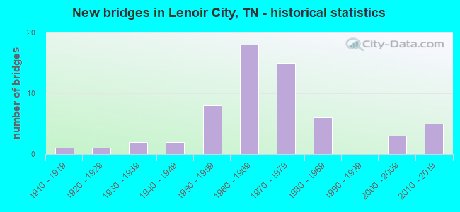
- New bridges - historical statistics
- 11910-1919
- 11920-1929
- 21930-1939
- 21940-1949
- 81950-1959
- 181960-1969
- 151970-1979
- 61980-1989
- 32000-2009
- 52010-2019
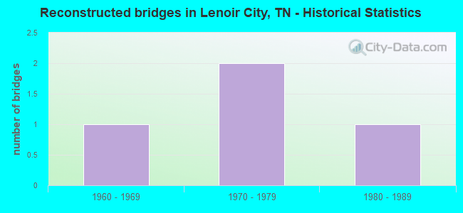
- Reconstructed bridges - Historical Statistics
- 11960-1969
- 21970-1979
- 11980-1989
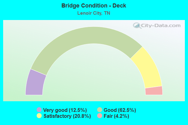
- Bridge Condition - Deck
- 12.5%Very good
- 62.5%Good
- 20.8%Satisfactory
- 4.2%Fair
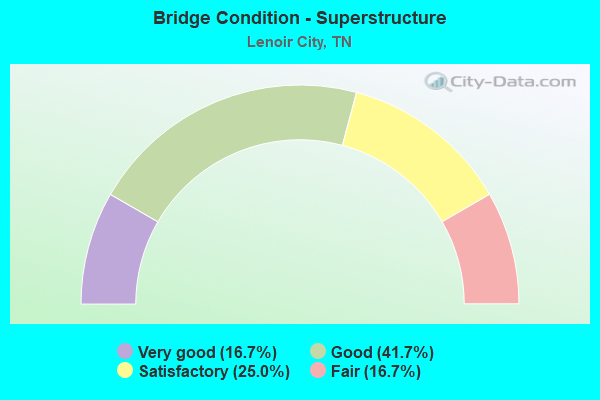
- Bridge Condition - Superstructure
- 16.7%Very good
- 41.7%Good
- 25.0%Satisfactory
- 16.7%Fair
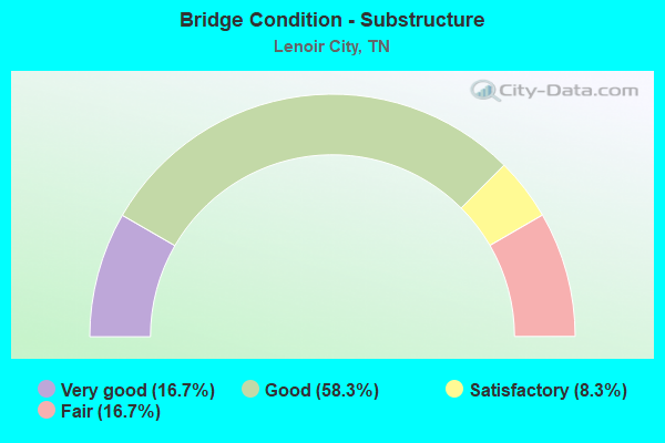
- Bridge Condition - Substructure
- 16.7%Very good
- 58.3%Good
- 8.3%Satisfactory
- 16.7%Fair
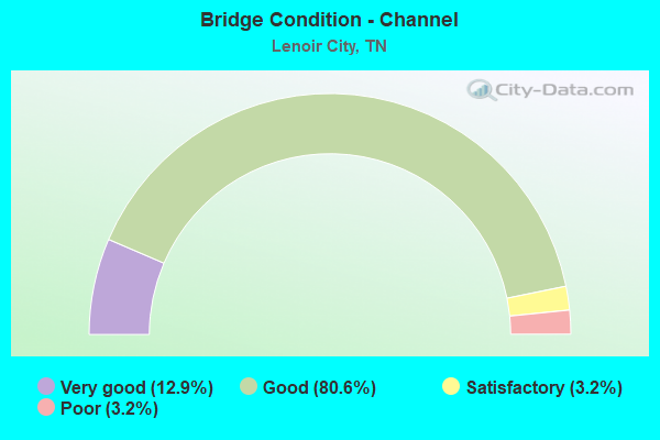
- Bridge Condition - Channel
- 12.9%Very good
- 80.6%Good
- 3.2%Satisfactory
- 3.2%Poor
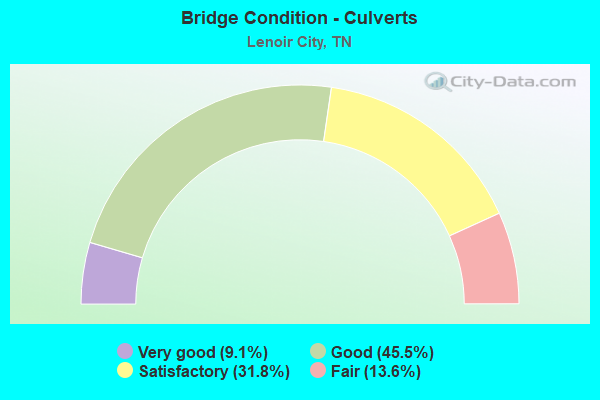
- Bridge Condition - Culverts
- 9.1%Very good
- 45.5%Good
- 31.8%Satisfactory
- 13.6%Fair
Find on map >> Show street view
Structure Number: 730A2350005, Location: S OFF I40 ON LOUDON CO LN (Lat: 35.875967, Lng: -84.334683), Route carried "on" structure: County highway 485, Year Built: 1934, Status: Open, Structure Length: 1.10m (3.61ft), Average Daily Traffic: 330 (year 2022), Truck Traffic: 2%, Average Future Daily Traffic: 528 (year 2039), Features Intersected: PAW PAW CREEK
Minimum Vertical Clearance: 30+ m (98+ ft), Kilometerpoint: 5.694, Lanes on structure: 2, Owner: County Highway Agency, Approaching Roadway Width: 6.4m (21.0ft), Material/Design: Steel, Design/Construction: Stringer/Multi-beam, Number Of Spans In Main Unit: 1, Length of Maximum Span: 10.7m (35.1ft), Curb-To-Curb Width: 6.1m (20.0ft), Out-to-Out Width: 6.5m (21.3ft)
Condition: Deck: Satisfactory, Superstructure: Satisfactory, Substructure: Fair, Channel: Satisfactory, Operating Rating: 39.6 metric tons, Method Used To Determine Operating Rating: Load Factor (LF), Inventory Rating: 24.3 metric tons, Method Used To Determine Inventory Rating: Load Factor (LF), Structural Evaluation: Somewhat better than minimum adequacy, Deck Geometry: Meets minimum limits, Waterway Adequacy: Better than present minimum criteria, Approach Roadway Alignment: Equal to present minimum criteria, Length Of Structure Improvement: 1.10m (3.61ft), Designated Inspection Frequency: Every 24 months, Inspection Date: March 2021, Bridge Improvement Cost: $96,000, Roadway Improvement Cost: $10,000, Total Project Cost: $145,000 ( Estimate for 2019), Deck Structure Type: Concrete Cast-file-Place, Wearing Surface/Protective System: Wearing Surface: Bituminous
Find on map >> Show street view
Structure Number: 730A2420003, Location: S OFF I40 AT LOUDON CO LN (Lat: 35.879100, Lng: -84.335417), Route carried "on" structure: County highway 92, Year Built: 1965, Status: Open, Structure Length: 1.28m (4.20ft), Average Daily Traffic: 10 (year 2022), Truck Traffic: 2%, Average Future Daily Traffic: 16 (year 2041), Features Intersected: PAW PAW CREEK
Minimum Vertical Clearance: 30+ m (98+ ft), Kilometerpoint: 0.172, Lanes on structure: 2, Owner: County Highway Agency, Approaching Roadway Width: 5.2m (17.1ft), Material/Design: Concrete continuous, Design/Construction: Culvert, Number Of Spans In Main Unit: 4, Length of Maximum Span: 3.0m (9.8ft), Curb-To-Curb Width: 5.0m (16.4ft), Out-to-Out Width: 5.6m (18.4ft)
Condition: Channel: Good, Culverts: Good, Operating Rating: 42.3 metric tons, Method Used To Determine Operating Rating: Load Factor (LF), Inventory Rating: 26.1 metric tons, Method Used To Determine Inventory Rating: Load Factor (LF), Structural Evaluation: Equal to present minimum criteria, Deck Geometry: High priority of corrective action, Waterway Adequacy: Better than present minimum criteria, Approach Roadway Alignment: Equal to present desirable criteria, Designated Inspection Frequency: Every 24 months, Inspection Date: March 2021, Wearing Surface/Protective System: Wearing Surface: Bituminous
Find on map >> Show street view
Structure Number: 73I00400037, Location: .2 M W LOUDON CO LN (Lat: 35.879167, Lng: -84.335517), Route carried "on" structure: Interstate 40, Year Built: 1970, Status: Open, Structure Length: 1.31m (4.30ft), Average Daily Traffic: 39,707 (year 2020), Truck Traffic: 23%, Average Future Daily Traffic: 70,912 (year 2040), Design Load: HS 20, Features Intersected: PAW PAW CREEK
Minimum Vertical Clearance: 30+ m (98+ ft), Kilometerpoint: 36.790, Lanes on structure: 4, Base Highway Network: Yes, Owner: State Highway Agency, Approaching Roadway Width: 26.8m (87.9ft), Skew: 10 degrees, Material/Design: Concrete continuous, Design/Construction: Culvert, Number Of Spans In Main Unit: 4, Length of Maximum Span: 3.0m (9.8ft)
Condition: Channel: Good, Culverts: Satisfactory, Operating Rating: 54.0 metric tons, Method Used To Determine Operating Rating: Field evaluation and documented engineering judgment, Inventory Rating: 32.4 metric tons, Method Used To Determine Inventory Rating: Field evaluation and documented engineering judgment, Structural Evaluation: Equal to present minimum criteria, Waterway Adequacy: Better than present minimum criteria, Approach Roadway Alignment: Equal to present desirable criteria, Length Of Structure Improvement: 1.31m (4.30ft), Designated Inspection Frequency: Every 24 months, Inspection Date: September 2020, Bridge Improvement Cost: $429,000, Roadway Improvement Cost: $43,000, Total Project Cost: $644,000 ( Estimate for 2020)
Find on map >> Show street view
Structure Number: 53012490001, Location: BELOW TELLICO DAM (Lat: 35.781667, Lng: -84.255000), Route carried "on" structure: State highway 444, Year Built: 1981, Status: Open, Structure Length: 14.17m (46.49ft), Average Daily Traffic: 9,302 (year 2021), Truck Traffic: 5%, Average Future Daily Traffic: 15,000 (year 2041), Design Load: HS 20, Features Intersected: LITTLE TENNESSEE RIVER
Minimum Vertical Clearance: 30+ m (98+ ft), Kilometerpoint: 0.000, Lanes on structure: 2, Owner: Tennessee Valley Authority, Approaching Roadway Width: 12.2m (40.0ft), Navigation Control: Yes ( Vertical Clearance: 12.1m (39.7ft), Horizontal Clearance: 21.3m (69.9ft)), Material/Design: Steel continuous, Design/Construction: Stringer/Multi-beam, Number Of Spans In Main Unit: 5, Length of Maximum Span: 31.7m (104.0ft), Curb or Sidewalk Widths: Left: 0.2m (0.7ft), Right: 0.2m (0.7ft), Curb-To-Curb Width: 9.1m (29.9ft), Out-to-Out Width: 10.2m (33.5ft)
Condition: Deck: Good, Superstructure: Good, Substructure: Satisfactory, Channel: Good, Operating Rating: 51.8 metric tons, Method Used To Determine Operating Rating: Load Factor (LF), Inventory Rating: 31.1 metric tons, Method Used To Determine Inventory Rating: Load Factor (LF), Structural Evaluation: Equal to present minimum criteria, Deck Geometry: Meets minimum limits, Waterway Adequacy: Superior to present desirable criteria, Approach Roadway Alignment: Equal to present desirable criteria, Designated Inspection Frequency: Every 24 months, Underwater Inspection Frequency: Every 60 months, Inspection Date: September 2021, Underwater Inspection Date: August 2019, Deck Structure Type: Concrete Cast-file-Place, Wearing Surface/Protective System: Wearing Surface: Epoxy Overlay
Find on map >> Show street view
Structure Number: 530A1860001, Location: FT LOUDOUN DAM (Lat: 35.791667, Lng: -84.241667), Route carried "on" structure: County highway 188, Year Built: 1940, Status: Open, Structure Length: 0.64m (2.10ft), Average Daily Traffic: 50 (year 2021), Truck Traffic: 2%, Average Future Daily Traffic: 60 (year 2041), Design Load: HS 20, Features Intersected: MUDDY CREEK, Facility Carried by Structure: POWERHOUSE ACCESS
Minimum Vertical Clearance: 30+ m (98+ ft), Kilometerpoint: 3.701, Lanes on structure: 2, Owner: Tennessee Valley Authority, Approaching Roadway Width: 9.8m (32.2ft), Skew: 6 degrees, Material/Design: Concrete, Design/Construction: Culvert, Number Of Spans In Main Unit: 1, Length of Maximum Span: 5.2m (17.1ft), Curb or Sidewalk Widths: Left: 1.5m (4.9ft), Right: 0.0m
Condition: Channel: Good, Culverts: Satisfactory, Operating Rating: 54.0 metric tons, Method Used To Determine Operating Rating: Load Factor (LF), Inventory Rating: 32.4 metric tons, Method Used To Determine Inventory Rating: Load Factor (LF), Structural Evaluation: Equal to present minimum criteria, Waterway Adequacy: Equal to present desirable criteria, Approach Roadway Alignment: Somewhat better than minimum adequacy, Designated Inspection Frequency: Every 24 months, Underwater Inspection Frequency: Every 60 months, Inspection Date: September 2021, Underwater Inspection Date: March 2021, Wearing Surface/Protective System: Wearing Surface: Bituminous
Find on map >> Show street view
Structure Number: 53011350001, Location: 2 M S OF US11-US70 JCT (Lat: 35.822017, Lng: -84.220483), Route carried "under" structure: County highway 1135, Year Built: 1918, Structure Length: 0. m, Average Daily Traffic: 3,054 (year 2020), Truck Traffic: 3%, Features Intersected: SOUTHERN RAILWAY, Facility Carried by Structure: SOU RWY 731476S
Minimum Vertical Clearance: 4.47m (14.67ft), Kilometerpoint: 4.200, Lanes under structure: 2, Material/Design: Steel, Design/Construction: Stringer/Multi-beam, Length of Maximum Span: 6.6m (21.7ft)
Find on map >> Show street view
Structure Number: 53I00400001, Location: 7 M. NW. LENOIR CITY. (Lat: 35.878467, Lng: -84.333233), Route carried "under" structure: County highway 485, Year Built: 1960, Structure Length: 0. m, Average Daily Traffic: 550 (year 2022), Truck Traffic: 5%, Features Intersected: I40 RT LN, Facility Carried by Structure: I40 RL
Minimum Vertical Clearance: 4.85m (15.91ft), Kilometerpoint: 0.275, Lanes on structure: 2, Lanes under structure: 2, Material/Design: Concrete continuous, Design/Construction: Tee Beam, Length of Maximum Span: 14.8m (48.6ft)
Find on map >> Show street view
Structure Number: 53I00400002, Location: 7 M. NW. LENOIR CITY (Lat: 35.878600, Lng: -84.333067), Route carried "under" structure: County highway 485, Year Built: 1960, Structure Length: 0. m, Average Daily Traffic: 550 (year 2022), Truck Traffic: 5%, Features Intersected: I40 LF LN, Facility Carried by Structure: I40 LL
Minimum Vertical Clearance: 4.93m (16.17ft), Kilometerpoint: 0.311, Lanes on structure: 2, Lanes under structure: 2, Material/Design: Concrete continuous, Design/Construction: Tee Beam, Length of Maximum Span: 14.8m (48.6ft)
Find on map >> Show street view
Structure Number: 53I00400005, Location: NEAR EATON TENN. (Lat: 35.874650, Lng: -84.324417), Route carried "under" structure: State highway 73, Year Built: 1959, Structure Length: 0. m, Average Daily Traffic: 8,620 (year 2020), Truck Traffic: 9%, Features Intersected: I40, Facility Carried by Structure: I40
Minimum Vertical Clearance: 4.33m (14.21ft), Kilometerpoint: 0.016, Lanes on structure: 2, Lanes under structure: 4, Material/Design: Steel, Design/Construction: Stringer/Multi-beam, Length of Maximum Span: 21.8m (71.5ft)
Find on map >> Show street view
Structure Number: 53I00400006, Location: NEAR EATON TENN. (Lat: 35.874950, Lng: -84.324350), Route carried "under" structure: State highway 95, Year Built: 1959, Structure Length: 0. m, Average Daily Traffic: 5,599 (year 2020), Truck Traffic: 9%, Features Intersected: I40, Facility Carried by Structure: I40
Minimum Vertical Clearance: 4.32m (14.17ft), Kilometerpoint: 15.916, Lanes on structure: 2, Lanes under structure: 2, Material/Design: Steel, Design/Construction: Stringer/Multi-beam, Length of Maximum Span: 21.8m (71.5ft)
Find on map >> Show street view
Structure Number: 53I00750031, Location: 2.3 M. NW. LENOIR CITY. (Lat: 35.808167, Lng: -84.306083), Route carried "under" structure: County highway 5928, Year Built: 1972, Structure Length: 0. m, Average Daily Traffic: 970 (year 2020), Truck Traffic: 3%, Features Intersected: HOTCHKISS VALLEY RD., Facility Carried by Structure: I-75 NB
Minimum Vertical Clearance: 4.53m (14.86ft), Kilometerpoint: 4.627, Lanes on structure: 2, Lanes under structure: 2, Material/Design: Prestressed concrete, Design/Construction: Stringer/Multi-beam, Length of Maximum Span: 23.8m (78.1ft)
Find on map >> Show street view
Structure Number: 53I00750032, Location: 2.3 M. NW. LENOIR CITY (Lat: 35.808217, Lng: -84.306450), Route carried "under" structure: County highway 5928, Year Built: 1972, Structure Length: 0. m, Average Daily Traffic: 970 (year 2020), Truck Traffic: 3%, Features Intersected: HOTCHKISS VALLEY RD., Facility Carried by Structure: I-75 SB
Minimum Vertical Clearance: 4.32m (14.17ft), Kilometerpoint: 4.587, Lanes on structure: 2, Lanes under structure: 2, Material/Design: Prestressed concrete continuous, Design/Construction: Stringer/Multi-beam, Length of Maximum Span: 23.8m (78.1ft)
Find on map >> Show street view
Structure Number: 53I00750033, Location: 2.5 M. NW. LENOIR CITY. (Lat: 35.821517, Lng: -84.288683), Route carried "under" structure: County highway 1247, Year Built: 1972, Structure Length: 0. m, Average Daily Traffic: 6,893 (year 2020), Truck Traffic: 3%, Features Intersected: OLD SR-95, Facility Carried by Structure: I-75 NB
Minimum Vertical Clearance: 4.80m (15.75ft), Kilometerpoint: 4.281, Lanes on structure: 2, Lanes under structure: 2, Material/Design: Prestressed concrete continuous, Design/Construction: Stringer/Multi-beam, Length of Maximum Span: 20.7m (67.9ft)
Find on map >> Show street view
Structure Number: 53I00750034, Location: 2.5 M. NW. LENOIR CITY. (Lat: 35.821583, Lng: -84.288800), Route carried "under" structure: County highway 1247, Year Built: 1972, Structure Length: 0. m, Average Daily Traffic: 6,893 (year 2020), Truck Traffic: 3%, Features Intersected: OLD SR-95, Facility Carried by Structure: I-75 SB
Minimum Vertical Clearance: 4.22m (13.85ft), Kilometerpoint: 4.313, Lanes on structure: 2, Lanes under structure: 2, Material/Design: Prestressed concrete continuous, Design/Construction: Stringer/Multi-beam, Length of Maximum Span: 20.7m (67.9ft)
Find on map >> Show street view
Structure Number: 53I00750035, Location: NEAR LOUDON TENN. (Lat: 35.828450, Lng: -84.279700), Route carried "under" structure: Interstate 75, Year Built: 1962, Structure Length: 0. m, Average Daily Traffic: 50,703 (year 2020), Truck Traffic: 27%, Features Intersected: SR 73, Facility Carried by Structure: FAP 73
Minimum Vertical Clearance: 4.37m (14.34ft), Kilometerpoint: 24.092, Lanes on structure: 6, Lanes under structure: 4, Material/Design: Concrete continuous, Design/Construction: Tee Beam, Length of Maximum Span: 24.4m (80.1ft)
Find on map >> Show street view
Structure Number: 53I00750037, Location: NEAR LOUDON TENN. (Lat: 35.858683, Lng: -84.258567), Route carried "under" structure: Interstate 75, Year Built: 1958, Structure Length: 0. m, Average Daily Traffic: 54,184 (year 2020), Truck Traffic: 25%, Features Intersected: NFA 1279 HICKORY VLY RD, Facility Carried by Structure: NFA 1279
Minimum Vertical Clearance: 4.65m (15.26ft), Kilometerpoint: 28.341, Lanes on structure: 2, Lanes under structure: 4, Material/Design: Concrete continuous, Design/Construction: Tee Beam, Length of Maximum Span: 20.0m (65.6ft)
Find on map >> Show street view
Structure Number: 53I00750039, Location: NEAR LOUDON TENN. (Lat: 35.843400, Lng: -84.270783), Route carried "under" structure: US 70, Year Built: 1962, Structure Length: 0. m, Average Daily Traffic: 7,065 (year 2020), Truck Traffic: 4%, Features Intersected: I75, Facility Carried by Structure: I75
Minimum Vertical Clearance: 5.77m (18.93ft), Kilometerpoint: 6.904, Lanes on structure: 2, Lanes under structure: 2, Material/Design: Concrete continuous, Design/Construction: Tee Beam, Length of Maximum Span: 18.9m (62.0ft)
Find on map >> Show street view
Structure Number: 53I0075004, Location: NEAR LOUDON TENN. (Lat: 35.843250, Lng: -84.271100), Route carried "under" structure: US 70, Year Built: 1962, Structure Length: 0. m, Average Daily Traffic: 7,065 (year 2020), Truck Traffic: 4%, Features Intersected: I75, Facility Carried by Structure: I75
Minimum Vertical Clearance: 4.65m (15.26ft), Kilometerpoint: 6.872, Lanes on structure: 2, Lanes under structure: 2, Material/Design: Concrete continuous, Design/Construction: Tee Beam, Length of Maximum Span: 18.9m (62.0ft)
Find on map >> Show street view
Structure Number: 53SR0950009, Location: JUST S OF FT LOUDON DAM (Lat: 35.781467, Lng: -84.242833), Route carried "under" structure: State highway 444, Year Built: 1975, Structure Length: 0. m, Average Daily Traffic: 9,302 (year 2020), Truck Traffic: 4%, Features Intersected: SR 73, Facility Carried by Structure: FAP 73
Minimum Vertical Clearance: 4.30m (14.11ft), Kilometerpoint: 17.413, Lanes on structure: 2, Lanes under structure: 2, Material/Design: Steel continuous, Design/Construction: Stringer/Multi-beam, Length of Maximum Span: 80.5m (264.1ft)
Find on map >> Show street view
Structure Number: 53SR095001, Location: JUST S OF FT LOUDON DAM (Lat: 35.781467, Lng: -84.242833), Route carried "under" structure: State highway 444, Year Built: 2017, Structure Length: 0. m, Average Daily Traffic: 9,302 (year 2020), Truck Traffic: 4%, Features Intersected: SR 73, Facility Carried by Structure: FAP 73
Minimum Vertical Clearance: 4.87m (15.98ft), Kilometerpoint: 17.397, Lanes on structure: 2, Lanes under structure: 2, Material/Design: Steel continuous, Design/Construction: Stringer/Multi-beam, Length of Maximum Span: 78.0m (255.9ft)