Bridge Statistics for Le Mars, Iowa (IA)
Condition, Traffic, Stress, Structural Evaluation, Project Costs
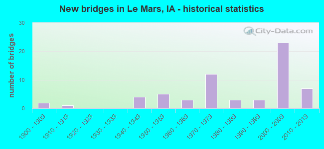
- New bridges - historical statistics
- 21900-1909
- 11910-1919
- 41940-1949
- 51950-1959
- 31960-1969
- 121970-1979
- 31980-1989
- 31990-1999
- 232000-2009
- 72010-2019
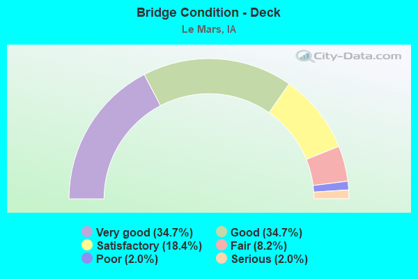
- Bridge Condition - Deck
- 34.7%Very good
- 34.7%Good
- 18.4%Satisfactory
- 8.2%Fair
- 2.0%Poor
- 2.0%Serious
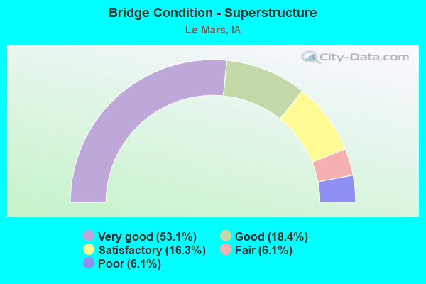
- Bridge Condition - Superstructure
- 53.1%Very good
- 18.4%Good
- 16.3%Satisfactory
- 6.1%Fair
- 6.1%Poor
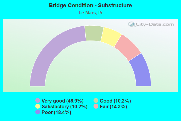
- Bridge Condition - Substructure
- 46.9%Very good
- 10.2%Good
- 10.2%Satisfactory
- 14.3%Fair
- 18.4%Poor
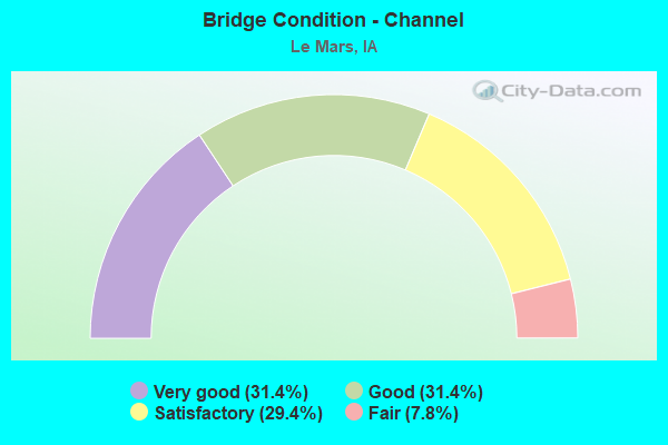
- Bridge Condition - Channel
- 31.4%Very good
- 31.4%Good
- 29.4%Satisfactory
- 7.8%Fair
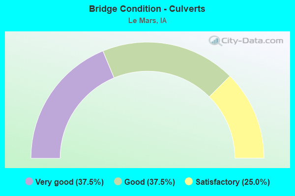
- Bridge Condition - Culverts
- 37.5%Very good
- 37.5%Good
- 25.0%Satisfactory
Find on map >> Show street view
Structure Number: 27678, Location: 093452605 (Lat: 42.851394, Lng: -96.127064), Route carried "on" structure: County highway , Year Built: 1954, Status: Posted for load, Structure Length: 5.94m (19.49ft), Average Daily Traffic: 60 (year 2019), Average Future Daily Traffic: 60 (year 2041), Design Load: HS 20, Features Intersected: FLOYD RIVER, Facility Carried by Structure: 140TH ST
Minimum Vertical Clearance: 30+ m (98+ ft), Kilometerpoint: 33.273, Lanes on structure: 2, Owner: County Highway Agency, Approaching Roadway Width: 7.0m (23.0ft), Material/Design: Steel, Design/Construction: Truss - Thru, Number Of Spans In Main Unit: 2, Number Of Approach Spans: 1, Length of Maximum Span: 24.4m (80.1ft), Curb-To-Curb Width: 6.0m (19.7ft), Out-to-Out Width: 6.1m (20.0ft)
Condition: Deck: Poor, Superstructure: Poor, Substructure: Poor, Channel: Satisfactory, Operating Rating: 10.8 metric tons, Method Used To Determine Operating Rating: Load Factor (LF), Inventory Rating: 6.4 metric tons, Method Used To Determine Inventory Rating: Load Factor (LF), Structural Evaluation: High priority of replacement, Deck Geometry: Meets minimum limits, Waterway Adequacy: Equal to present desirable criteria, Approach Roadway Alignment: Equal to present minimum criteria, Bridge Posting: Required (Relationship of Operating Rating to Maximum Legal Load: > 39.9% below), Length Of Structure Improvement: 25.00m (82.02ft), Designated Inspection Frequency: Every 12 months, Critical Feature Inspection Frequency: Every 12 months, Inspection Date: June 2021, Critical Feature Inspection Date: June 2021, Bridge Improvement Cost: $750,000, Roadway Improvement Cost: $20,000, Deck Structure Type: Concrete Cast-file-Place, Wearing Surface/Protective System: Wearing Surface: Monolithic Concrete
Find on map >> Show street view
Structure Number: 2768, Location: 093453101 (Lat: 42.836686, Lng: -96.201722), Route carried "on" structure: County highway , Year Built: 1963, Status: Posted for load, Structure Length: 5.33m (17.49ft), Average Daily Traffic: 50 (year 2019), Average Future Daily Traffic: 50 (year 2041), Design Load: H 15, Features Intersected: W BR FLOYD RIVER, Facility Carried by Structure: 150TH ST
Minimum Vertical Clearance: 30+ m (98+ ft), Kilometerpoint: 28.168, Lanes on structure: 2, Owner: County Highway Agency, Approaching Roadway Width: 8.2m (26.9ft), Material/Design: Steel continuous, Design/Construction: Stringer/Multi-beam, Number Of Spans In Main Unit: 3, Length of Maximum Span: 20.7m (67.9ft), Curb-To-Curb Width: 7.3m (24.0ft), Out-to-Out Width: 8.0m (26.2ft)
Condition: Deck: Satisfactory, Superstructure: Satisfactory, Substructure: Fair, Channel: Fair, Operating Rating: 35.5 metric tons, Method Used To Determine Operating Rating: Load Factor (LF), Inventory Rating: 15.5 metric tons, Method Used To Determine Inventory Rating: Load Factor (LF), Structural Evaluation: Meets minimum limits, Deck Geometry: Equal to present minimum criteria, Waterway Adequacy: Equal to present desirable criteria, Approach Roadway Alignment: Equal to present desirable criteria, Bridge Posting: Required (Relationship of Operating Rating to Maximum Legal Load: 0.1 - 9.9% below), Length Of Structure Improvement: 22.00m (72.18ft), Designated Inspection Frequency: Every 12 months, Inspection Date: June 2021, Bridge Improvement Cost: $660,000, Roadway Improvement Cost: $20,000, Deck Structure Type: Concrete Cast-file-Place, Wearing Surface/Protective System: Wearing Surface: Monolithic Concrete
Find on map >> Show street view
Structure Number: 276811, Location: 9345310210 (Lat: 42.832292, Lng: -96.213578), Route carried "on" structure: County highway , Year Built: 2018, Status: Open, Structure Length: 0.79m (2.59ft), Average Daily Traffic: 40 (year 2019), Average Future Daily Traffic: 40 (year 2041), Design Load: HL 93, Features Intersected: DRAINAGE, Facility Carried by Structure: KEY AVE
Minimum Vertical Clearance: 30+ m (98+ ft), Kilometerpoint: 18.390, Lanes on structure: 2, Owner: County Highway Agency, Approaching Roadway Width: 12.2m (40.0ft), Material/Design: Concrete, Design/Construction: Culvert, Number Of Spans In Main Unit: 1, Length of Maximum Span: 7.3m (24.0ft), Curb or Sidewalk Widths: Left: 6.4m (21.0ft), Right: 6.4m (21.0ft)
Condition: Channel: Very good, Culverts: Very good, Operating Rating: 43.4 metric tons, Method Used To Determine Operating Rating: Assigned ratings based on Load and Resistance Factor Design (LRFD) reported by rating factor (RF) using HL93 loadings, Inventory Rating: 33.4 metric tons, Method Used To Determine Inventory Rating: Assigned ratings based on Load and Resistance Factor Design (LRFD) reported by rating factor (RF) using HL93 loadings, Structural Evaluation: Equal to present desirable criteria, Waterway Adequacy: Equal to present desirable criteria, Approach Roadway Alignment: Equal to present desirable criteria, Designated Inspection Frequency: Every 24 months, Inspection Date: June 2021
Find on map >> Show street view
Structure Number: 276831, Location: 9345330110 (Lat: 42.836947, Lng: -96.155111), Route carried "on" structure: County highway , Year Built: 2016, Status: Open, Structure Length: 2.23m (7.32ft), Average Daily Traffic: 70 (year 2019), Average Future Daily Traffic: 70 (year 2041), Design Load: HL 93, Features Intersected: WOLF CREEK, Facility Carried by Structure: 150TH ST
Minimum Vertical Clearance: 30+ m (98+ ft), Kilometerpoint: 31.978, Lanes on structure: 2, Owner: County Highway Agency, Approaching Roadway Width: 8.7m (28.5ft), Material/Design: Steel, Design/Construction: Stringer/Multi-beam, Number Of Spans In Main Unit: 1, Length of Maximum Span: 21.3m (69.9ft), Curb-To-Curb Width: 9.3m (30.5ft), Out-to-Out Width: 9.5m (31.2ft)
Condition: Deck: Very good, Superstructure: Very good, Substructure: Good, Channel: Very good, Operating Rating: 60.6 metric tons, Method Used To Determine Operating Rating: Load and Resistance Factor Rating (LRFR) rating reported by rating factor(RF) method using HL-93 loadings, Inventory Rating: 46.7 metric tons, Method Used To Determine Inventory Rating: Load and Resistance Factor Rating (LRFR) rating reported by rating factor(RF) method using HL-93 loadings, Structural Evaluation: Better than present minimum criteria, Deck Geometry: Better than present minimum criteria, Waterway Adequacy: Equal to present desirable criteria, Approach Roadway Alignment: Equal to present desirable criteria, Designated Inspection Frequency: Every 24 months, Inspection Date: June 2021, Deck Structure Type: Concrete Cast-file-Place, Wearing Surface/Protective System: Wearing Surface: Gravel
Find on map >> Show street view
Structure Number: 27684, Location: 093453403 (Lat: 42.836944, Lng: -96.150033), Route carried "on" structure: County highway , Year Built: 1954, Status: Posted for load, Structure Length: 5.33m (17.49ft), Average Daily Traffic: 130 (year 2019), Truck Traffic: 38%, Average Future Daily Traffic: 130 (year 2041), Design Load: H 15, Features Intersected: FLOYD RIVER, Facility Carried by Structure: 150TH ST
Minimum Vertical Clearance: 30+ m (98+ ft), Kilometerpoint: 32.393, Lanes on structure: 2, Owner: County Highway Agency, Approaching Roadway Width: 9.1m (29.9ft), Material/Design: Steel continuous, Design/Construction: Stringer/Multi-beam, Number Of Spans In Main Unit: 3, Length of Maximum Span: 20.7m (67.9ft), Curb-To-Curb Width: 6.1m (20.0ft), Out-to-Out Width: 6.7m (22.0ft)
Condition: Deck: Satisfactory, Superstructure: Fair, Substructure: Poor, Channel: Satisfactory, Operating Rating: 30.8 metric tons, Method Used To Determine Operating Rating: Load Factor (LF), Inventory Rating: 18.4 metric tons, Method Used To Determine Inventory Rating: Load Factor (LF), Structural Evaluation: Meets minimum limits, Deck Geometry: Meets minimum limits, Waterway Adequacy: Equal to present desirable criteria, Approach Roadway Alignment: Equal to present desirable criteria, Bridge Posting: Required (Relationship of Operating Rating to Maximum Legal Load: 20.0 - 29.9% below), Length Of Structure Improvement: 23.00m (75.46ft), Designated Inspection Frequency: Every 12 months, Inspection Date: June 2021, Other Special Inspection Date: March 2010, Bridge Improvement Cost: $690,000, Roadway Improvement Cost: $20,000, Deck Structure Type: Concrete Cast-file-Place, Wearing Surface/Protective System: Wearing Surface: Monolithic Concrete
Find on map >> Show street view
Structure Number: 276861, Location: 9345360210 (Lat: 42.823803, Lng: -96.115219), Route carried "on" structure: County highway , Year Built: 2018, Status: Open, Structure Length: 4.36m (14.30ft), Average Daily Traffic: 30 (year 2019), Average Future Daily Traffic: 30 (year 2041), Design Load: HL 93, Features Intersected: DEEP CREEK, Facility Carried by Structure: NATURE AVE
Minimum Vertical Clearance: 30+ m (98+ ft), Kilometerpoint: 29.156, Lanes on structure: 2, Owner: County Highway Agency, Approaching Roadway Width: 10.4m (34.1ft), Material/Design: Concrete continuous, Design/Construction: Slab, Number Of Spans In Main Unit: 1, Number Of Approach Spans: 2, Length of Maximum Span: 16.8m (55.1ft), Curb-To-Curb Width: 9.3m (30.5ft), Out-to-Out Width: 10.1m (33.1ft)
Condition: Deck: Very good, Superstructure: Very good, Substructure: Very good, Channel: Very good, Operating Rating: 42.1 metric tons, Method Used To Determine Operating Rating: Assigned ratings based on Load and Resistance Factor Design (LRFD) reported by rating factor (RF) using HL93 loadings, Inventory Rating: 32.4 metric tons, Method Used To Determine Inventory Rating: Assigned ratings based on Load and Resistance Factor Design (LRFD) reported by rating factor (RF) using HL93 loadings, Structural Evaluation: Equal to present desirable criteria, Deck Geometry: Better than present minimum criteria, Waterway Adequacy: Equal to present desirable criteria, Approach Roadway Alignment: Equal to present desirable criteria, Designated Inspection Frequency: Every 24 months, Inspection Date: June 2021, Deck Structure Type: Concrete Cast-file-Place
Find on map >> Show street view
Structure Number: 276871, Location: 9345360220 (Lat: 42.828183, Lng: -96.115217), Route carried "on" structure: County highway , Year Built: 2018, Status: Open, Structure Length: 4.05m (13.29ft), Average Daily Traffic: 30 (year 2019), Average Future Daily Traffic: 30 (year 2041), Design Load: HL 93, Features Intersected: WILLOW CREEK, Facility Carried by Structure: NATURE AVE
Minimum Vertical Clearance: 30+ m (98+ ft), Kilometerpoint: 29.644, Lanes on structure: 2, Owner: County Highway Agency, Approaching Roadway Width: 10.1m (33.1ft), Skew: 1 degrees, Material/Design: Concrete continuous, Design/Construction: Slab, Number Of Spans In Main Unit: 1, Number Of Approach Spans: 2, Length of Maximum Span: 15.5m (50.9ft), Curb-To-Curb Width: 9.3m (30.5ft), Out-to-Out Width: 10.1m (33.1ft)
Condition: Deck: Very good, Superstructure: Very good, Substructure: Very good, Channel: Very good, Operating Rating: 42.1 metric tons, Method Used To Determine Operating Rating: Assigned ratings based on Load and Resistance Factor Design (LRFD) reported by rating factor (RF) using HL93 loadings, Inventory Rating: 32.4 metric tons, Method Used To Determine Inventory Rating: Assigned ratings based on Load and Resistance Factor Design (LRFD) reported by rating factor (RF) using HL93 loadings, Structural Evaluation: Equal to present desirable criteria, Deck Geometry: Better than present minimum criteria, Waterway Adequacy: Equal to present desirable criteria, Approach Roadway Alignment: Equal to present desirable criteria, Designated Inspection Frequency: Every 24 months, Inspection Date: June 2021, Deck Structure Type: Concrete Cast-file-Place
Find on map >> Show street view
Structure Number: 36469, Location: 1.0 mi. N of jct. SR C38 (Lat: 42.764108, Lng: -96.209750), Route carried "on" structure: City street , Year Built: 2006, Status: Open, Structure Length: 7.16m (23.49ft), Average Daily Traffic: 5,200 (year 2019), Average Future Daily Traffic: 5,200 (year 2042), Design Load: HS 20, Features Intersected: IA 75, Facility Carried by Structure: 200TH STREET
Minimum Vertical Clearance: 30+ m (98+ ft), Kilometerpoint: 1.516, Lanes on structure: 4, Lanes under structure: 4, Owner: State Highway Agency, Approaching Roadway Width: 20.7m (67.9ft), Material/Design: Prestressed concrete, Design/Construction: Stringer/Multi-beam, Number Of Spans In Main Unit: 2, Length of Maximum Span: 35.1m (115.2ft), Curb-To-Curb Width: 20.7m (67.9ft), Out-to-Out Width: 21.7m (71.2ft)
Condition: Deck: Very good, Superstructure: Very good, Substructure: Very good, Operating Rating: 84.7 metric tons, Method Used To Determine Operating Rating: Load Factor (LF), Inventory Rating: 29.3 metric tons, Method Used To Determine Inventory Rating: Load Factor (LF), Structural Evaluation: Better than present minimum criteria, Deck Geometry: Superior to present desirable criteria, Underclear: Equal to present minimum criteria, Approach Roadway Alignment: Equal to present desirable criteria, Designated Inspection Frequency: Every 24 months, Inspection Date: January 2022, Deck Structure Type: Concrete Cast-file-Place, Wearing Surface/Protective System: Wearing Surface: Monolithic Concrete, Deck Protection: Epoxy Coated Reinforcing
Find on map >> Show street view
Structure Number: 364695, Location: F22030515 (Lat: 42.764125, Lng: -96.206408), Route carried "on" structure: City street , Year Built: 2007, Status: Open, Structure Length: 30.51m (100.10ft), Average Daily Traffic: 8,600 (year 2019), Average Future Daily Traffic: 8,600 (year 2041), Design Load: HS 20, Features Intersected: FLOYD RIVER, Facility Carried by Structure: 200TH STREET
Minimum Vertical Clearance: 30+ m (98+ ft), Kilometerpoint: 1.790, Lanes on structure: 4, Owner: City or Municipal Highway Agency, Approaching Roadway Width: 18.3m (60.0ft), Material/Design: Steel, Design/Construction: Stringer/Multi-beam, Number Of Spans In Main Unit: 7, Length of Maximum Span: 44.8m (147.0ft), Curb-To-Curb Width: 16.8m (55.1ft), Out-to-Out Width: 17.4m (57.1ft)
Condition: Deck: Good, Superstructure: Good, Substructure: Fair, Channel: Fair, Operating Rating: 44.4 metric tons, Method Used To Determine Operating Rating: Load Factor (LF), Inventory Rating: 32.7 metric tons, Method Used To Determine Inventory Rating: Load Factor (LF), Structural Evaluation: Somewhat better than minimum adequacy, Deck Geometry: Somewhat better than minimum adequacy, Waterway Adequacy: Equal to present desirable criteria, Approach Roadway Alignment: Equal to present desirable criteria, Designated Inspection Frequency: Every 24 months, Inspection Date: December 2021, Deck Structure Type: Concrete Cast-file-Place, Wearing Surface/Protective System: Wearing Surface: Monolithic Concrete
Find on map >> Show street view
Structure Number: 60132, Location: 2.5 MI. E of US 75 (Bus.) (Lat: 42.804900, Lng: -96.131325), Route carried "on" structure: State highway 3, Year Built: 1994, Status: Open, Structure Length: 0.88m (2.89ft), Average Daily Traffic: 3,470 (year 2020), Truck Traffic: 11%, Average Future Daily Traffic: 3,470 (year 2042), Design Load: HS 20, Features Intersected: STREAM
Minimum Vertical Clearance: 30+ m (98+ ft), Kilometerpoint: 48.459, Lanes on structure: 2, Base Highway Network: Yes, Owner: State Highway Agency, Approaching Roadway Width: 16.5m (54.1ft), Skew: 3 degrees, Material/Design: Concrete continuous, Design/Construction: Culvert, Number Of Spans In Main Unit: 2, Length of Maximum Span: 4.3m (14.1ft)
Condition: Channel: Satisfactory, Culverts: Satisfactory, Operating Rating: 47.6 metric tons, Method Used To Determine Operating Rating: Load Factor (LF), Inventory Rating: 28.5 metric tons, Method Used To Determine Inventory Rating: Load Factor (LF), Structural Evaluation: Equal to present minimum criteria, Waterway Adequacy: Equal to present desirable criteria, Approach Roadway Alignment: Equal to present desirable criteria, Designated Inspection Frequency: Every 24 months, Inspection Date: Febuary 2022
Find on map >> Show street view
Structure Number: 609205, Location: 0.4 mi. S of jct. SR C16 (Lat: 42.860525, Lng: -96.123592), Route carried "on" structure: State highway 60, Year Built: 2003, Status: Open, Structure Length: 0.64m (2.10ft), Average Daily Traffic: 6,200 (year 2020), Truck Traffic: 21%, Average Future Daily Traffic: 6,200 (year 2041), Design Load: HS 20, Features Intersected: DRAINAGE DITCH
Minimum Vertical Clearance: 30+ m (98+ ft), Kilometerpoint: 7.220, Lanes on structure: 4, Base Highway Network: Yes, Owner: State Highway Agency, Approaching Roadway Width: 28.0m (91.9ft), Skew: 20 degrees, Material/Design: Concrete continuous, Design/Construction: Culvert, Number Of Spans In Main Unit: 2, Length of Maximum Span: 3.0m (9.8ft)
Condition: Channel: Very good, Culverts: Very good, Operating Rating: 34.3 metric tons, Method Used To Determine Operating Rating: Load and Resistance Factor Rating (LRFR) rating reported by rating factor(RF) method using HL-93 loadings, Inventory Rating: 26.6 metric tons, Method Used To Determine Inventory Rating: Load and Resistance Factor Rating (LRFR) rating reported by rating factor(RF) method using HL-93 loadings, Structural Evaluation: Equal to present minimum criteria, Waterway Adequacy: Equal to present desirable criteria, Approach Roadway Alignment: Equal to present desirable criteria, Designated Inspection Frequency: Every 24 months, Inspection Date: October 2021
Find on map >> Show street view
Structure Number: 60936, Location: At the Jct. U.S. 75 (Lat: 42.793050, Lng: -96.204739), Route carried "on" structure: State highway 3, Year Built: 2005, Status: Open, Structure Length: 7.47m (24.51ft), Average Daily Traffic: 3,300 (year 2020), Truck Traffic: 10%, Average Future Daily Traffic: 3,300 (year 2042), Design Load: HS 20, Features Intersected: US 75 (LEMARS BYPASS)
Minimum Vertical Clearance: 30+ m (98+ ft), Kilometerpoint: 41.911, Lanes on structure: 2, Lanes under structure: 4, Base Highway Network: Yes, Owner: State Highway Agency, Approaching Roadway Width: 18.3m (60.0ft), Skew: 1 degrees, Material/Design: Prestressed concrete, Design/Construction: Stringer/Multi-beam, Number Of Spans In Main Unit: 2, Length of Maximum Span: 36.6m (120.1ft), Curb-To-Curb Width: 18.2m (59.7ft), Out-to-Out Width: 19.2m (63.0ft)
Condition: Deck: Good, Superstructure: Very good, Substructure: Very good, Operating Rating: 90.2 metric tons, Method Used To Determine Operating Rating: Load Factor (LF), Inventory Rating: 34.6 metric tons, Method Used To Determine Inventory Rating: Load Factor (LF), Structural Evaluation: Equal to present desirable criteria, Deck Geometry: Superior to present desirable criteria, Underclear: Somewhat better than minimum adequacy, Approach Roadway Alignment: Equal to present desirable criteria, Designated Inspection Frequency: Every 24 months, Inspection Date: January 2022, Deck Structure Type: Concrete Cast-file-Place, Wearing Surface/Protective System: Wearing Surface: Monolithic Concrete, Deck Protection: Epoxy Coated Reinforcing
Find on map >> Show street view
Structure Number: 60937, Location: At jct. IA 60 (Lat: 42.817839, Lng: -96.174619), Route carried "on" structure: US 75, Year Built: 2005, Status: Open, Structure Length: 7.13m (23.39ft), Average Daily Traffic: 1,870 (year 2020), Truck Traffic: 18%, Average Future Daily Traffic: 1,870 (year 2042), Design Load: HS 20, Features Intersected: IA 60
Minimum Vertical Clearance: 30+ m (98+ ft), Kilometerpoint: 50.455, Lanes on structure: 2, Lanes under structure: 4, Base Highway Network: Yes, Owner: State Highway Agency, Approaching Roadway Width: 10.7m (35.1ft), Material/Design: Prestressed concrete, Design/Construction: Stringer/Multi-beam, Number Of Spans In Main Unit: 2, Length of Maximum Span: 35.1m (115.2ft), Curb-To-Curb Width: 10.7m (35.1ft), Out-to-Out Width: 13.9m (45.6ft)
Condition: Deck: Very good, Superstructure: Very good, Substructure: Very good, Operating Rating: 90.5 metric tons, Method Used To Determine Operating Rating: Load Factor (LF), Inventory Rating: 39.2 metric tons, Method Used To Determine Inventory Rating: Load Factor (LF), Structural Evaluation: Equal to present desirable criteria, Deck Geometry: Somewhat better than minimum adequacy, Underclear: Somewhat better than minimum adequacy, Approach Roadway Alignment: Equal to present desirable criteria, Designated Inspection Frequency: Every 24 months, Inspection Date: January 2022, Deck Structure Type: Concrete Cast-file-Place, Wearing Surface/Protective System: Wearing Surface: Monolithic Concrete, Deck Protection: Epoxy Coated Reinforcing
Find on map >> Show street view
Structure Number: 609375, Location: At jct. Iowa 60 (Lat: 42.818431, Lng: -96.174792), Route carried "on" structure: State highway 404, Year Built: 2005, Status: Open, Structure Length: 7.13m (23.39ft), Average Daily Traffic: 1,870 (year 2020), Truck Traffic: 18%, Average Future Daily Traffic: 1,870 (year 2042), Design Load: HS 20, Features Intersected: IA 60, Facility Carried by Structure: US 75 SB
Minimum Vertical Clearance: 30+ m (98+ ft), Kilometerpoint: 0.134, Lanes on structure: 2, Lanes under structure: 4, Owner: State Highway Agency, Approaching Roadway Width: 10.7m (35.1ft), Material/Design: Prestressed concrete, Design/Construction: Stringer/Multi-beam, Number Of Spans In Main Unit: 3, Length of Maximum Span: 35.1m (115.2ft), Curb-To-Curb Width: 10.7m (35.1ft), Out-to-Out Width: 13.9m (45.6ft)
Condition: Deck: Very good, Superstructure: Very good, Substructure: Very good, Operating Rating: 90.5 metric tons, Method Used To Determine Operating Rating: Load Factor (LF), Inventory Rating: 39.2 metric tons, Method Used To Determine Inventory Rating: Load Factor (LF), Structural Evaluation: Equal to present desirable criteria, Deck Geometry: Somewhat better than minimum adequacy, Underclear: Somewhat better than minimum adequacy, Approach Roadway Alignment: Equal to present desirable criteria, Designated Inspection Frequency: Every 24 months, Inspection Date: January 2022, Deck Structure Type: Concrete Cast-file-Place, Wearing Surface/Protective System: Wearing Surface: Monolithic Concrete, Deck Protection: Epoxy Coated Reinforcing
Find on map >> Show street view
Structure Number: 609455, Location: 1.5 mi. N of jct. US 75 (Lat: 42.832669, Lng: -96.156117), Route carried "on" structure: State highway 60, Year Built: 2004, Status: Open, Structure Length: 1.19m (3.90ft), Average Daily Traffic: 5,600 (year 2020), Truck Traffic: 23%, Average Future Daily Traffic: 5,600 (year 2041), Design Load: HS 20, Features Intersected: WOLF CREEK
Minimum Vertical Clearance: 30+ m (98+ ft), Kilometerpoint: 2.990, Lanes on structure: 4, Base Highway Network: Yes, Owner: State Highway Agency, Approaching Roadway Width: 28.0m (91.9ft), Skew: 23 degrees, Material/Design: Concrete continuous, Design/Construction: Culvert, Number Of Spans In Main Unit: 3, Length of Maximum Span: 3.7m (12.1ft)
Condition: Channel: Very good, Culverts: Good, Operating Rating: 28.8 metric tons, Method Used To Determine Operating Rating: Load and Resistance Factor Rating (LRFR) rating reported by rating factor(RF) method using HL-93 loadings, Inventory Rating: 22.4 metric tons, Method Used To Determine Inventory Rating: Load and Resistance Factor Rating (LRFR) rating reported by rating factor(RF) method using HL-93 loadings, Structural Evaluation: Somewhat better than minimum adequacy, Waterway Adequacy: Equal to present desirable criteria, Approach Roadway Alignment: Equal to present desirable criteria, Designated Inspection Frequency: Every 24 months, Inspection Date: October 2021
Find on map >> Show street view
Structure Number: 60946, Location: 1.1 mi S of jct IA 60 (Lat: 42.811664, Lng: -96.194242), Route carried "on" structure: US 75, Year Built: 2006, Status: Open, Structure Length: 7.07m (23.20ft), Average Daily Traffic: 2,700 (year 2020), Truck Traffic: 34%, Average Future Daily Traffic: 2,700 (year 2042), Design Load: HS 20, Features Intersected: LAKE AVENUE
Minimum Vertical Clearance: 30+ m (98+ ft), Kilometerpoint: 48.522, Lanes on structure: 2, Lanes under structure: 2, Base Highway Network: Yes, Owner: State Highway Agency, Approaching Roadway Width: 12.8m (42.0ft), Skew: 4 degrees, Material/Design: Prestressed concrete, Design/Construction: Stringer/Multi-beam, Number Of Spans In Main Unit: 3, Length of Maximum Span: 29.3m (96.1ft), Curb-To-Curb Width: 12.6m (41.3ft), Out-to-Out Width: 13.6m (44.6ft)
Condition: Deck: Very good, Superstructure: Very good, Substructure: Very good, Operating Rating: 75.1 metric tons, Method Used To Determine Operating Rating: Load Factor (LF), Inventory Rating: 45.1 metric tons, Method Used To Determine Inventory Rating: Load Factor (LF), Structural Evaluation: Equal to present desirable criteria, Deck Geometry: Better than present minimum criteria, Underclear: Better than present minimum criteria, Approach Roadway Alignment: Equal to present desirable criteria, Designated Inspection Frequency: Every 24 months, Inspection Date: January 2022, Deck Structure Type: Concrete Cast-file-Place, Wearing Surface/Protective System: Wearing Surface: Monolithic Concrete, Deck Protection: Epoxy Coated Reinforcing
Find on map >> Show street view
Structure Number: 609465, Location: 1.1 mi S of jct IA 60 (Lat: 42.812433, Lng: -96.193775), Route carried "on" structure: US 75, Year Built: 2006, Status: Open, Structure Length: 7.07m (23.20ft), Average Daily Traffic: 2,700 (year 2020), Truck Traffic: 34%, Average Future Daily Traffic: 2,700 (year 2042), Design Load: HS 20, Features Intersected: LAKE AVENUE
Minimum Vertical Clearance: 30+ m (98+ ft), Kilometerpoint: 79.885, Lanes on structure: 2, Lanes under structure: 2, Owner: State Highway Agency, Approaching Roadway Width: 12.8m (42.0ft), Skew: 4 degrees, Material/Design: Prestressed concrete, Design/Construction: Stringer/Multi-beam, Number Of Spans In Main Unit: 3, Length of Maximum Span: 29.3m (96.1ft), Curb-To-Curb Width: 12.6m (41.3ft), Out-to-Out Width: 13.6m (44.6ft)
Condition: Deck: Very good, Superstructure: Very good, Substructure: Very good, Operating Rating: 75.1 metric tons, Method Used To Determine Operating Rating: Load Factor (LF), Inventory Rating: 45.1 metric tons, Method Used To Determine Inventory Rating: Load Factor (LF), Structural Evaluation: Equal to present desirable criteria, Deck Geometry: Better than present minimum criteria, Underclear: Better than present minimum criteria, Approach Roadway Alignment: Equal to present desirable criteria, Designated Inspection Frequency: Every 24 months, Inspection Date: January 2022, Deck Structure Type: Concrete Cast-file-Place, Wearing Surface/Protective System: Wearing Surface: Monolithic Concrete, Deck Protection: Epoxy Coated Reinforcing
Find on map >> Show street view
Structure Number: 36469, Location: 1.0 mi. N of jct. SR C38 (Lat: 42.764108, Lng: -96.209750), Route carried "under" structure: US 75, Year Built: 2006, Structure Length: 0. m, Average Daily Traffic: 6,600 (year 2020), Truck Traffic: 29%, Features Intersected: IA 75, Facility Carried by Structure: 200TH STREET
Minimum Vertical Clearance: 30+ m (98+ ft), Kilometerpoint: 43.006, Lanes on structure: 4, Lanes under structure: 4, Material/Design: Prestressed concrete, Design/Construction: Stringer/Multi-beam, Length of Maximum Span: 35.1m (115.2ft)
Find on map >> Show street view
Structure Number: 60936, Location: At the Jct. U.S. 75 (Lat: 42.793050, Lng: -96.204739), Route carried "under" structure: US 75, Year Built: 2005, Structure Length: 0. m, Average Daily Traffic: 5,200 (year 2020), Truck Traffic: 34%, Features Intersected: US 75 (LEMARS BYPASS), Facility Carried by Structure: IOWA 3
Minimum Vertical Clearance: 30+ m (98+ ft), Kilometerpoint: 46.270, Lanes on structure: 2, Lanes under structure: 4, Material/Design: Prestressed concrete, Design/Construction: Stringer/Multi-beam, Length of Maximum Span: 36.6m (120.1ft)
Find on map >> Show street view
Structure Number: 60937, Location: At jct. IA 60 (Lat: 42.817839, Lng: -96.174619), Route carried "under" structure: State highway 60, Year Built: 2005, Structure Length: 0. m, Average Daily Traffic: 1,870 (year 2020), Truck Traffic: 31%, Features Intersected: IA 60, Facility Carried by Structure: US 75 NB
Minimum Vertical Clearance: 30+ m (98+ ft), Kilometerpoint: 0.505, Lanes on structure: 2, Lanes under structure: 4, Material/Design: Prestressed concrete, Design/Construction: Stringer/Multi-beam, Length of Maximum Span: 35.1m (115.2ft)
Find on map >> Show street view
Structure Number: 609375, Location: At jct. Iowa 60 (Lat: 42.818431, Lng: -96.174792), Route carried "under" structure: State highway 60, Year Built: 2005, Structure Length: 0. m, Average Daily Traffic: 1,870 (year 2020), Truck Traffic: 31%, Features Intersected: IA 60, Facility Carried by Structure: US 75 SB
Minimum Vertical Clearance: 30+ m (98+ ft), Kilometerpoint: 0.489, Lanes on structure: 2, Lanes under structure: 4, Material/Design: Prestressed concrete, Design/Construction: Stringer/Multi-beam, Length of Maximum Span: 35.1m (115.2ft)
Find on map >> Show street view
Structure Number: 60946, Location: 1.1 mi S of jct IA 60 (Lat: 42.811664, Lng: -96.194242), Route carried "under" structure: County highway , Year Built: 2006, Structure Length: 0. m, Average Daily Traffic: 50 (year 2019), Features Intersected: LAKE AVENUE, Facility Carried by Structure: US 75 NB
Minimum Vertical Clearance: 30+ m (98+ ft), Kilometerpoint: 24.874, Lanes on structure: 2, Lanes under structure: 2, Material/Design: Prestressed concrete, Design/Construction: Stringer/Multi-beam, Length of Maximum Span: 29.3m (96.1ft)
Find on map >> Show street view
Structure Number: 609465, Location: 1.1 mi S of jct IA 60 (Lat: 42.812433, Lng: -96.193775), Route carried "under" structure: County highway , Year Built: 2006, Structure Length: 0. m, Average Daily Traffic: 50 (year 2019), Features Intersected: LAKE AVENUE, Facility Carried by Structure: US 75 SB
Minimum Vertical Clearance: 30+ m (98+ ft), Kilometerpoint: 24.917, Lanes on structure: 2, Lanes under structure: 2, Material/Design: Prestressed concrete, Design/Construction: Stringer/Multi-beam, Length of Maximum Span: 29.3m (96.1ft)