Bridge Statistics for Lawton, Oklahoma (OK)
Condition, Traffic, Stress, Structural Evaluation, Project Costs
- National Bridge Inventory (NBI) Statistics
- 261Number of bridges
- 2,044ft / 623mTotal length
- $223,090,000Total costs
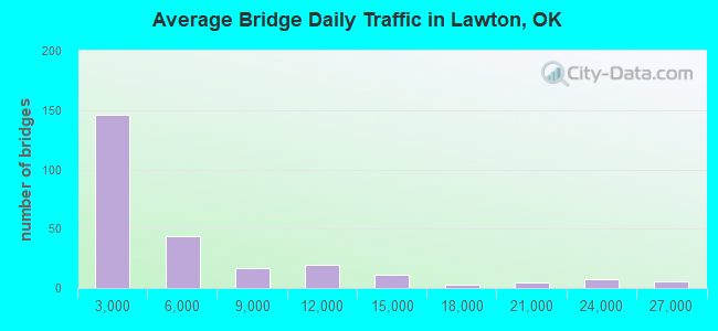
- 1,246,576Total average daily traffic
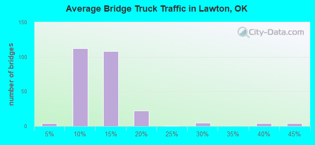
- 129,778Total average daily truck traffic
- National Bridge Inventory (NBI) Registered Bridges for Lawton
- No street view available for this location
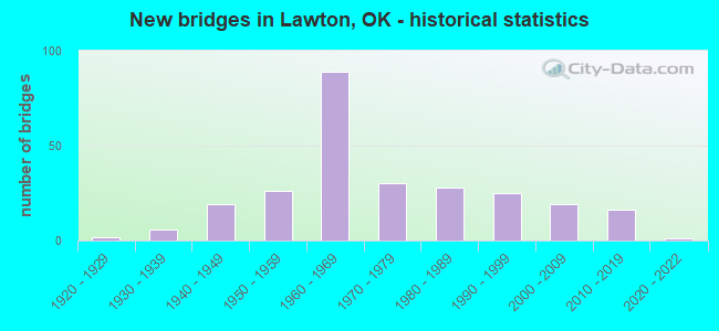
- New bridges - historical statistics
- 21920-1929
- 61930-1939
- 191940-1949
- 261950-1959
- 891960-1969
- 301970-1979
- 281980-1989
- 251990-1999
- 192000-2009
- 162010-2019
- 12020-2022
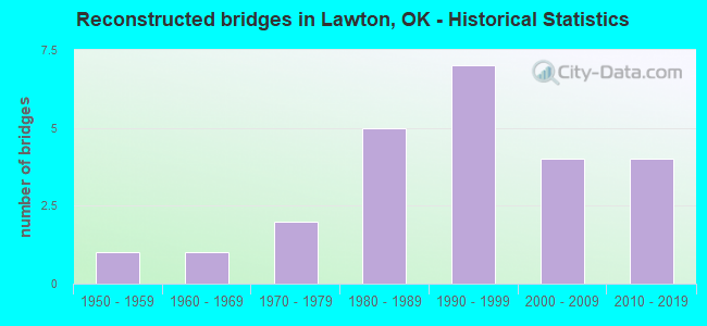
- Reconstructed bridges - Historical Statistics
- 11950-1959
- 11960-1969
- 21970-1979
- 51980-1989
- 71990-1999
- 42000-2009
- 42010-2019
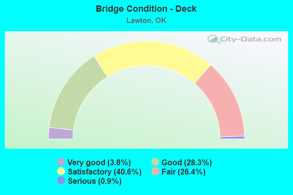
- Bridge Condition - Deck
- 3.8%Very good
- 28.3%Good
- 40.6%Satisfactory
- 26.4%Fair
- 0.9%Serious
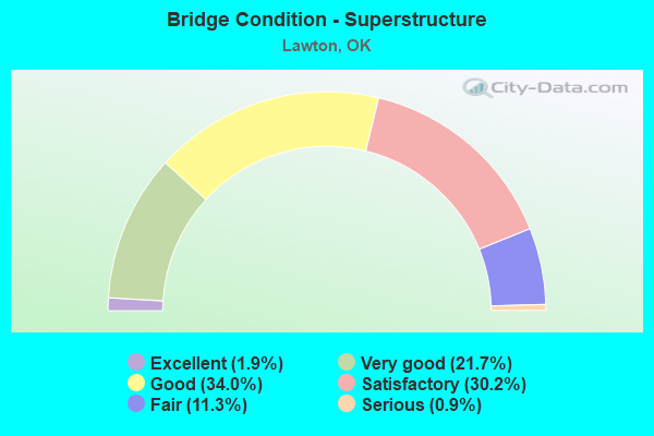
- Bridge Condition - Superstructure
- 1.9%Excellent
- 21.7%Very good
- 34.0%Good
- 30.2%Satisfactory
- 11.3%Fair
- 0.9%Serious
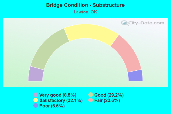
- Bridge Condition - Substructure
- 8.5%Very good
- 29.2%Good
- 32.1%Satisfactory
- 23.6%Fair
- 6.6%Poor
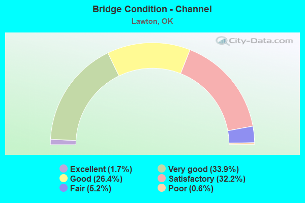
- Bridge Condition - Channel
- 1.7%Excellent
- 33.9%Very good
- 26.4%Good
- 32.2%Satisfactory
- 5.2%Fair
- 0.6%Poor
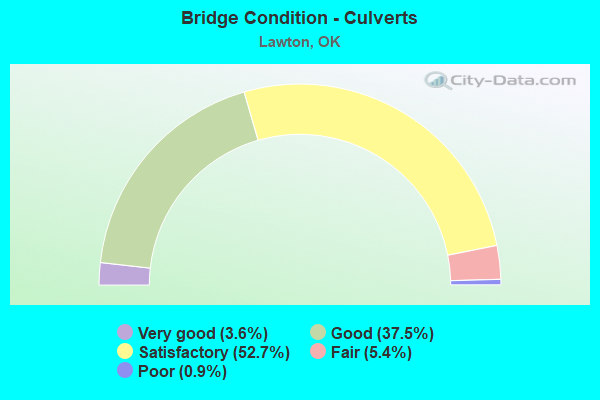
- Bridge Condition - Culverts
- 3.6%Very good
- 37.5%Good
- 52.7%Satisfactory
- 5.4%Fair
- 0.9%Poor
Find on map >> Show street view
Structure Number: DAPTRASIL000C13, Location: 0.11 MI W OF FIREBREAK 33 (Lat: 34.753919, Lng: -98.319000), Route carried "on" structure: Other road , Year Built: 1965, Status: Open, Structure Length: 0.65m (2.13ft), Average Daily Traffic: 400 (year 2020), Truck Traffic: 10%, Average Future Daily Traffic: 400 (year 2042), Features Intersected: BEEF CREEK, Facility Carried by Structure: EAST BOUNDARY RD
Minimum Vertical Clearance: 30+ m (98+ ft), Kilometerpoint: 0.000, Lanes on structure: 2, Owner: Army, Approaching Roadway Width: 6.7m (22.0ft), Material/Design: Concrete, Design/Construction: Culvert, Number Of Spans In Main Unit: 2, Length of Maximum Span: 3.1m (10.2ft)
Condition: Channel: Good, Culverts: Satisfactory, Operating Rating: 54.5 metric tons, Method Used To Determine Operating Rating: Field evaluation and documented engineering judgment, Inventory Rating: 32.7 metric tons, Method Used To Determine Inventory Rating: Field evaluation and documented engineering judgment, Structural Evaluation: Equal to present minimum criteria, Waterway Adequacy: Equal to present desirable criteria, Approach Roadway Alignment: Equal to present desirable criteria, Length Of Structure Improvement: 1.27m (4.17ft), Designated Inspection Frequency: Every 24 months, Inspection Date: September 2020, Bridge Improvement Cost: $1,000, Roadway Improvement Cost: $1,000, Total Project Cost: $2,000 ( Estimate for 2020)
Find on map >> Show street view
Structure Number: DAPTRASIL000N14, Location: FORT SILL ARMY POST (Lat: 34.660789, Lng: -98.400819), Route carried "on" structure: ServiceOther road , Year Built: 1943, Status: Posted for load, Structure Length: 0.78m (2.56ft), Average Daily Traffic: 1,400 (year 2020), Average Future Daily Traffic: 1,400 (year 2042), Features Intersected: UNNAMED, Facility Carried by Structure: HOSKINS RD
Minimum Vertical Clearance: 30+ m (98+ ft), Kilometerpoint: 0.000, Lanes on structure: 2, Owner: Army, Approaching Roadway Width: 7.3m (24.0ft), Material/Design: Concrete, Design/Construction: Culvert, Number Of Spans In Main Unit: 3, Length of Maximum Span: 2.4m (7.9ft)
Condition: Channel: Good, Culverts: Satisfactory, Operating Rating: 47.3 metric tons, Method Used To Determine Operating Rating: Field evaluation and documented engineering judgment, Inventory Rating: 32.7 metric tons, Method Used To Determine Inventory Rating: Field evaluation and documented engineering judgment, Structural Evaluation: Equal to present minimum criteria, Waterway Adequacy: Equal to present desirable criteria, Approach Roadway Alignment: Equal to present desirable criteria, Bridge Posting: Required (Relationship of Operating Rating to Maximum Legal Load: 10.0 - 19.9% below), Length Of Structure Improvement: 1.43m (4.69ft), Designated Inspection Frequency: Every 24 months, Inspection Date: September 2020, Bridge Improvement Cost: $1,000, Roadway Improvement Cost: $1,000, Total Project Cost: $2,000 ( Estimate for 2020)
Find on map >> Show street view
Structure Number: DAPTRASIL000N16, Location: FORT SILL ARMY POST (Lat: 34.670019, Lng: -98.372450), Route carried "on" structure: ServiceOther road , Year Built: 2012, Status: Posted for load, Structure Length: 3.17m (10.40ft), Average Daily Traffic: 600 (year 2020), Truck Traffic: 10%, Average Future Daily Traffic: 600 (year 2042), Design Load: HS 20+Mod, Features Intersected: EAST CACHE CK, Facility Carried by Structure: CORRAL ROAD
Minimum Vertical Clearance: 30+ m (98+ ft), Kilometerpoint: 0.000, Lanes on structure: 2, Owner: Army, Approaching Roadway Width: 9.1m (29.9ft), Material/Design: Concrete, Design/Construction: Culvert, Number Of Spans In Main Unit: 5, Length of Maximum Span: 6.1m (20.0ft), Curb-To-Curb Width: 9.1m (29.9ft), Out-to-Out Width: 11.0m (36.1ft)
Condition: Channel: Satisfactory, Culverts: Good, Operating Rating: 50.9 metric tons, Method Used To Determine Operating Rating: Load and Resistance Factor Rating (LRFR) rating reported by rating factor(RF) method using HL-93 loadings, Inventory Rating: 39.2 metric tons, Method Used To Determine Inventory Rating: Load and Resistance Factor Rating (LRFR) rating reported by rating factor(RF) method using HL-93 loadings, Structural Evaluation: Better than present minimum criteria, Deck Geometry: Equal to present minimum criteria, Waterway Adequacy: Equal to present desirable criteria, Approach Roadway Alignment: Equal to present minimum criteria, Length Of Structure Improvement: 4.03m (13.22ft), Designated Inspection Frequency: Every 24 months, Inspection Date: September 2020, Bridge Improvement Cost: $1,000, Roadway Improvement Cost: $1,000, Total Project Cost: $2,000 ( Estimate for 2020)
Find on map >> Show street view
Structure Number: DAPTRASIL0CRAIG, Location: E BR012 (Lat: 34.650531, Lng: -98.434061), Route carried "on" structure: ServiceOther road , Year Built: 1970, Status: Open, Structure Length: 0.98m (3.22ft), Average Daily Traffic: 400 (year 2020), Truck Traffic: 10%, Average Future Daily Traffic: 400 (year 2042), Features Intersected: SITTING BEAR CREEK, Facility Carried by Structure: CRAIG ROAD
Minimum Vertical Clearance: 30+ m (98+ ft), Kilometerpoint: 0.000, Lanes on structure: 2, Owner: Army, Approaching Roadway Width: 7.3m (24.0ft), Material/Design: Concrete, Design/Construction: Culvert, Number Of Spans In Main Unit: 3, Length of Maximum Span: 3.0m (9.8ft), Curb-To-Curb Width: 7.3m (24.0ft), Out-to-Out Width: 8.6m (28.2ft)
Condition: Channel: Good, Culverts: Fair, Operating Rating: 47.3 metric tons, Method Used To Determine Operating Rating: Field evaluation and documented engineering judgment, Inventory Rating: 32.7 metric tons, Method Used To Determine Inventory Rating: Field evaluation and documented engineering judgment, Structural Evaluation: Somewhat better than minimum adequacy, Deck Geometry: Somewhat better than minimum adequacy, Waterway Adequacy: Superior to present desirable criteria, Approach Roadway Alignment: Equal to present desirable criteria, Length Of Structure Improvement: 1.65m (5.41ft), Designated Inspection Frequency: Every 24 months, Inspection Date: September 2020, Bridge Improvement Cost: $1,000, Roadway Improvement Cost: $1,000, Total Project Cost: $2,000 ( Estimate for 2020)
Find on map >> Show street view
Structure Number: DAPTRASIL0EBDRY, Location: FORT SILL ARMY POST (Lat: 34.637961, Lng: -98.344089), Route carried "on" structure: ServiceOther road , Year Built: 1943, Status: Open, Structure Length: 0.64m (2.10ft), Average Daily Traffic: 100 (year 2020), Truck Traffic: 20%, Average Future Daily Traffic: 100 (year 2042), Features Intersected: OUTLET OF LAKE GEORGE, Facility Carried by Structure: S BOUNDARY RD
Minimum Vertical Clearance: 30+ m (98+ ft), Kilometerpoint: 0.000, Lanes on structure: 2, Owner: Army, Approaching Roadway Width: 7.3m (24.0ft), Material/Design: Concrete, Design/Construction: Slab, Number Of Spans In Main Unit: 1, Length of Maximum Span: 5.8m (19.0ft), Curb-To-Curb Width: 6.7m (22.0ft), Out-to-Out Width: 7.3m (24.0ft)
Condition: Deck: Fair, Superstructure: Fair, Substructure: Satisfactory, Channel: Satisfactory, Operating Rating: 54.5 metric tons, Method Used To Determine Operating Rating: Field evaluation and documented engineering judgment, Inventory Rating: 32.7 metric tons, Method Used To Determine Inventory Rating: Field evaluation and documented engineering judgment, Structural Evaluation: Somewhat better than minimum adequacy, Deck Geometry: Somewhat better than minimum adequacy, Waterway Adequacy: Equal to present minimum criteria, Approach Roadway Alignment: Equal to present desirable criteria, Length Of Structure Improvement: 1.26m (4.13ft), Designated Inspection Frequency: Every 24 months, Inspection Date: September 2020, Bridge Improvement Cost: $1,000, Roadway Improvement Cost: $1,000, Total Project Cost: $2,000 ( Estimate for 2020), Deck Structure Type: Concrete Cast-file-Place, Wearing Surface/Protective System: Wearing Surface: Bituminous
Find on map >> Show street view
Structure Number: DAPTRASIL0LW4M, Location: N OF ARTILLERY ROAD (Lat: 34.687689, Lng: -98.446731), Route carried "on" structure: Other road , Year Built: 2016, Status: Open, Structure Length: 3.17m (10.40ft), Average Daily Traffic: 400 (year 2020), Truck Traffic: 10%, Average Future Daily Traffic: 400 (year 2042), Design Load: HS 20+Mod, Features Intersected: MEDICINE CREEK, Facility Carried by Structure: TOWER TWO ROAD
Minimum Vertical Clearance: 30+ m (98+ ft), Kilometerpoint: 0.000, Lanes on structure: 2, Owner: Army, Approaching Roadway Width: 9.1m (29.9ft), Material/Design: Concrete, Design/Construction: Culvert, Number Of Spans In Main Unit: 5, Length of Maximum Span: 6.1m (20.0ft), Curb or Sidewalk Widths: Left: 0.3m (1.0ft), Right: 0.3m (1.0ft)
Condition: Channel: Good, Culverts: Good, Operating Rating: 74.2 metric tons, Method Used To Determine Operating Rating: Load and Resistance Factor Rating (LRFR) rating reported by rating factor(RF) method using HL-93 loadings, Inventory Rating: 57.3 metric tons, Method Used To Determine Inventory Rating: Load and Resistance Factor Rating (LRFR) rating reported by rating factor(RF) method using HL-93 loadings, Structural Evaluation: Better than present minimum criteria, Waterway Adequacy: Meets minimum limits, Approach Roadway Alignment: Equal to present desirable criteria, Length Of Structure Improvement: 4.03m (13.22ft), Designated Inspection Frequency: Every 24 months, Inspection Date: September 2020, Bridge Improvement Cost: $1,000, Roadway Improvement Cost: $1,000, Total Project Cost: $2,000 ( Estimate for 2020)
Find on map >> Show street view
Structure Number: DAPTRASIL0LWOAK, Location: NE OF NW BIG BOW RD (Lat: 34.638531, Lng: -98.719400), Route carried "on" structure: Other road , Year Built: 2019, Status: Open, Structure Length: 3.54m (11.61ft), Average Daily Traffic: 100 (year 2020), Truck Traffic: 10%, Average Future Daily Traffic: 100 (year 2042), Design Load: Greater than HL93, Features Intersected: POST OAK CREEK, Facility Carried by Structure: SOUTH BOUNDARY RD
Minimum Vertical Clearance: 30+ m (98+ ft), Kilometerpoint: 0.000, Lanes on structure: 2, Owner: Army, Approaching Roadway Width: 9.1m (29.9ft), Material/Design: Concrete, Design/Construction: Culvert, Number Of Spans In Main Unit: 9, Length of Maximum Span: 3.7m (12.1ft), Curb-To-Curb Width: 9.1m (29.9ft), Out-to-Out Width: 9.8m (32.2ft)
Condition: Channel: Satisfactory, Culverts: Good, Operating Rating: 42.1 metric tons, Method Used To Determine Operating Rating: Assigned ratings based on Load and Resistance Factor Design (LRFD) reported by rating factor (RF) using HL93 loadings, Inventory Rating: 32.4 metric tons, Method Used To Determine Inventory Rating: Assigned ratings based on Load and Resistance Factor Design (LRFD) reported by rating factor (RF) using HL93 loadings, Structural Evaluation: Better than present minimum criteria, Deck Geometry: Better than present minimum criteria, Waterway Adequacy: Better than present minimum criteria, Approach Roadway Alignment: Equal to present desirable criteria, Designated Inspection Frequency: Every 24 months, Inspection Date: September 2020
Find on map >> Show street view
Structure Number: DAPTRASIL0LWPIG, Location: FORT SILL ARMY POST (Lat: 34.643861, Lng: -98.361689), Route carried "on" structure: ServiceOther road , Year Built: 2016, Status: Closed, Structure Length: 3.23m (10.60ft), Average Daily Traffic: 400 (year 2020), Truck Traffic: 10%, Average Future Daily Traffic: 400 (year 2042), Design Load: HL 93, Features Intersected: EAST CACHE CREEK, Facility Carried by Structure: S. BOUNDARY RD
Minimum Vertical Clearance: 30+ m (98+ ft), Kilometerpoint: 0.000, Lanes on structure: 2, Owner: Army, Approaching Roadway Width: 7.4m (24.3ft), Skew: 1 degrees, Material/Design: Concrete, Design/Construction: Culvert, Number Of Spans In Main Unit: 5, Length of Maximum Span: 6.2m (20.3ft)
Condition: Channel: Satisfactory, Culverts: Good, Operating Rating: 44.7 metric tons, Method Used To Determine Operating Rating: Load and Resistance Factor Rating (LRFR) rating reported by rating factor(RF) method using HL-93 loadings, Inventory Rating: 34.3 metric tons, Method Used To Determine Inventory Rating: Load and Resistance Factor Rating (LRFR) rating reported by rating factor(RF) method using HL-93 loadings, Structural Evaluation: Better than present minimum criteria, Waterway Adequacy: Meets minimum limits, Approach Roadway Alignment: Equal to present desirable criteria, Length Of Structure Improvement: 4.10m (13.45ft), Designated Inspection Frequency: Every 24 months, Inspection Date: September 2020, Bridge Improvement Cost: $1,000, Roadway Improvement Cost: $1,000, Total Project Cost: $2,000 ( Estimate for 2020)
Find on map >> Show street view
Structure Number: DAPTRASIL0LWQUI, Location: FORT SILL ARMY POST (Lat: 34.678789, Lng: -98.392389), Route carried "on" structure: ServiceOther road , Year Built: 2009, Status: Open, Structure Length: 2.67m (8.76ft), Average Daily Traffic: 200 (year 2020), Truck Traffic: 10%, Average Future Daily Traffic: 200 (year 2042), Features Intersected: MEDICINE CREEK, Facility Carried by Structure: QUINETTE RD.
Minimum Vertical Clearance: 30+ m (98+ ft), Kilometerpoint: 0.000, Lanes on structure: 2, Owner: Army, Approaching Roadway Width: 7.3m (24.0ft), Skew: 4 degrees, Material/Design: Concrete, Design/Construction: Culvert, Number Of Spans In Main Unit: 3, Length of Maximum Span: 8.6m (28.2ft)
Condition: Channel: Satisfactory, Culverts: Satisfactory, Operating Rating: 54.5 metric tons, Method Used To Determine Operating Rating: Field evaluation and documented engineering judgment, Inventory Rating: 32.7 metric tons, Method Used To Determine Inventory Rating: Field evaluation and documented engineering judgment, Structural Evaluation: Equal to present minimum criteria, Waterway Adequacy: Equal to present minimum criteria, Approach Roadway Alignment: Equal to present desirable criteria, Length Of Structure Improvement: 3.58m (11.75ft), Designated Inspection Frequency: Every 24 months, Inspection Date: September 2020, Bridge Improvement Cost: $1,000, Roadway Improvement Cost: $1,000, Total Project Cost: $2,000 ( Estimate for 2020)
Find on map >> Show street view
Structure Number: DAPTRASIL0LWWCC, Location: FORT SILL ARMY POST (Lat: 34.650019, Lng: -98.650389), Route carried "on" structure: ServiceOther road , Year Built: 2018, Status: Closed, Structure Length: 2.29m (7.51ft), Average Daily Traffic: 30 (year 2020), Truck Traffic: 1%, Average Future Daily Traffic: 35 (year 2042), Design Load: HL 93, Features Intersected: WEST CACHE CREEK, Facility Carried by Structure: SOUTH BOUNDARY RD
Minimum Vertical Clearance: 30+ m (98+ ft), Kilometerpoint: 0.000, Lanes on structure: 2, Owner: Army, Approaching Roadway Width: 8.5m (27.9ft), Skew: 3 degrees, Material/Design: Concrete, Design/Construction: Culvert, Number Of Spans In Main Unit: 6, Length of Maximum Span: 3.5m (11.5ft), Curb-To-Curb Width: 9.8m (32.2ft), Out-to-Out Width: 10.4m (34.1ft)
Condition: Channel: Satisfactory, Culverts: Good, Operating Rating: 42.4 metric tons, Method Used To Determine Operating Rating: Field evaluation and documented engineering judgment, Inventory Rating: 32.7 metric tons, Method Used To Determine Inventory Rating: Field evaluation and documented engineering judgment, Structural Evaluation: Better than present minimum criteria, Deck Geometry: Equal to present desirable criteria, Waterway Adequacy: Equal to present desirable criteria, Approach Roadway Alignment: Equal to present desirable criteria, Length Of Structure Improvement: 0.83m (2.72ft), Designated Inspection Frequency: Every 24 months, Inspection Date: September 2020
Find on map >> Show street view
Structure Number: DAPTRASIL0PB02, Location: FORT SILL ARMY POST (Lat: 34.641531, Lng: -98.404689), Route carried "on" structure: ServiceOther road , Year Built: 1960, Status: Open, Structure Length: 0.79m (2.59ft), Average Daily Traffic: 3,000 (year 2020), Truck Traffic: 10%, Average Future Daily Traffic: 3,500 (year 2042), Features Intersected: UNKNOWN CREEK, Facility Carried by Structure: FT. SILL BLVD
Minimum Vertical Clearance: 30+ m (98+ ft), Kilometerpoint: 0.000, Lanes on structure: 2, Owner: Army, Approaching Roadway Width: 14.6m (47.9ft), Material/Design: Concrete, Design/Construction: Culvert, Number Of Spans In Main Unit: 3, Length of Maximum Span: 2.4m (7.9ft)
Condition: Channel: Satisfactory, Culverts: Good, Operating Rating: 55.3 metric tons, Method Used To Determine Operating Rating: Field evaluation and documented engineering judgment, Inventory Rating: 32.7 metric tons, Method Used To Determine Inventory Rating: Field evaluation and documented engineering judgment, Structural Evaluation: Better than present minimum criteria, Waterway Adequacy: Equal to present minimum criteria, Approach Roadway Alignment: Equal to present desirable criteria, Length Of Structure Improvement: 1.44m (4.72ft), Designated Inspection Frequency: Every 24 months, Inspection Date: September 2020, Bridge Improvement Cost: $1,000, Roadway Improvement Cost: $1,000, Total Project Cost: $2,000 ( Estimate for 2020)
Find on map >> Show street view
Structure Number: DAPTRASIL0PB101, Location: FORT SILL (Lat: 34.652469, Lng: -98.519450), Route carried "on" structure: ServiceOther road , Year Built: 2019, Status: Open, Structure Length: 0.78m (2.56ft), Average Daily Traffic: 400 (year 2020), Truck Traffic: 10%, Average Future Daily Traffic: 400 (year 2042), Design Load: HL 93, Features Intersected: PECAN CREEK, Facility Carried by Structure: MACKENZIE HILL RD
Minimum Vertical Clearance: 30+ m (98+ ft), Kilometerpoint: 0.000, Lanes on structure: 2, Owner: Army, Approaching Roadway Width: 7.8m (25.6ft), Material/Design: Concrete, Design/Construction: Culvert, Number Of Spans In Main Unit: 3, Length of Maximum Span: 2.4m (7.9ft)
Condition: Channel: Very good, Culverts: Good, Operating Rating: 95.6 metric tons, Method Used To Determine Operating Rating: Load and Resistance Factor Rating (LRFR) rating reported by rating factor(RF) method using HL-93 loadings, Inventory Rating: 73.5 metric tons, Method Used To Determine Inventory Rating: Load and Resistance Factor Rating (LRFR) rating reported by rating factor(RF) method using HL-93 loadings, Structural Evaluation: Better than present minimum criteria, Waterway Adequacy: Equal to present desirable criteria, Approach Roadway Alignment: Equal to present desirable criteria, Designated Inspection Frequency: Every 24 months, Inspection Date: September 2020
Find on map >> Show street view
Structure Number: DAPTRASIL0PB102, Location: FORT SILL ARMY POST (Lat: 34.652531, Lng: -98.588419), Route carried "on" structure: ServiceOther road , Year Built: 1945, Status: Open, Structure Length: 0.97m (3.18ft), Average Daily Traffic: 50 (year 2020), Truck Traffic: 1%, Average Future Daily Traffic: 70 (year 2042), Features Intersected: UNNAMED CREEK, Facility Carried by Structure: MCKENZIE HILL RD
Minimum Vertical Clearance: 30+ m (98+ ft), Kilometerpoint: 0.000, Lanes on structure: 2, Owner: Army, Approaching Roadway Width: 10.3m (33.8ft), Skew: 4 degrees, Material/Design: Concrete, Design/Construction: Culvert, Number Of Spans In Main Unit: 2, Length of Maximum Span: 4.6m (15.1ft)
Condition: Channel: Satisfactory, Culverts: Satisfactory, Operating Rating: 54.5 metric tons, Method Used To Determine Operating Rating: Field evaluation and documented engineering judgment, Inventory Rating: 32.7 metric tons, Method Used To Determine Inventory Rating: Field evaluation and documented engineering judgment, Structural Evaluation: Equal to present minimum criteria, Waterway Adequacy: Equal to present minimum criteria, Approach Roadway Alignment: Equal to present desirable criteria, Length Of Structure Improvement: 1.64m (5.38ft), Designated Inspection Frequency: Every 24 months, Inspection Date: September 2020, Bridge Improvement Cost: $1,000, Roadway Improvement Cost: $1,000, Total Project Cost: $2,000 ( Estimate for 2020)
Find on map >> Show street view
Structure Number: DAPTRASIL0PB113, Location: FOR SILL ARMY POST (Lat: 34.652439, Lng: -98.516500), Route carried "on" structure: ServiceOther road , Year Built: 1945, Status: Open, Structure Length: 0.64m (2.10ft), Average Daily Traffic: 400 (year 2020), Truck Traffic: 1%, Average Future Daily Traffic: 400 (year 2042), Features Intersected: UNNAMED CREEK, Facility Carried by Structure: MCKENZIE HILL RD
Minimum Vertical Clearance: 30+ m (98+ ft), Kilometerpoint: 0.000, Lanes on structure: 2, Owner: Army, Approaching Roadway Width: 8.8m (28.9ft), Material/Design: Concrete, Design/Construction: Culvert, Number Of Spans In Main Unit: 2, Length of Maximum Span: 3.0m (9.8ft)
Condition: Channel: Satisfactory, Culverts: Satisfactory, Operating Rating: 54.5 metric tons, Method Used To Determine Operating Rating: Field evaluation and documented engineering judgment, Inventory Rating: 32.7 metric tons, Method Used To Determine Inventory Rating: Field evaluation and documented engineering judgment, Structural Evaluation: Equal to present minimum criteria, Waterway Adequacy: Superior to present desirable criteria, Approach Roadway Alignment: Equal to present desirable criteria, Length Of Structure Improvement: 1.26m (4.13ft), Designated Inspection Frequency: Every 24 months, Inspection Date: September 2020, Bridge Improvement Cost: $1,000, Roadway Improvement Cost: $1,000, Total Project Cost: $2,000 ( Estimate for 2020)
Find on map >> Show street view
Structure Number: DAPTRASIL0VH004, Location: 0.62 M W OF E CACHE CK RD (Lat: 34.648061, Lng: -98.369269), Route carried "on" structure: ServiceOther road , Year Built: 1965, Status: Open, Structure Length: 0.98m (3.22ft), Average Daily Traffic: 400 (year 2020), Truck Traffic: 10%, Average Future Daily Traffic: 400 (year 2042), Features Intersected: SITTING BEAR CREEK, Facility Carried by Structure: S BOUNDARY RD
Minimum Vertical Clearance: 30+ m (98+ ft), Kilometerpoint: 0.000, Lanes on structure: 2, Owner: Army, Approaching Roadway Width: 5.9m (19.4ft), Material/Design: Concrete, Design/Construction: Culvert, Number Of Spans In Main Unit: 3, Length of Maximum Span: 3.0m (9.8ft)
Condition: Channel: Satisfactory, Culverts: Satisfactory, Operating Rating: 54.5 metric tons, Method Used To Determine Operating Rating: Field evaluation and documented engineering judgment, Inventory Rating: 32.7 metric tons, Method Used To Determine Inventory Rating: Field evaluation and documented engineering judgment, Structural Evaluation: Equal to present minimum criteria, Waterway Adequacy: Meets minimum limits, Approach Roadway Alignment: Equal to present desirable criteria, Length Of Structure Improvement: 1.65m (5.41ft), Designated Inspection Frequency: Every 24 months, Inspection Date: September 2020, Bridge Improvement Cost: $1,000, Roadway Improvement Cost: $1,000, Total Project Cost: $2,000 ( Estimate for 2020)
Find on map >> Show street view
Structure Number: DAPTRASIL0VH016, Location: 0.1 M S CURRIE RD (Lat: 34.643761, Lng: -98.411239), Route carried "on" structure: ServiceOther road , Year Built: 2007, Status: Open, Structure Length: 1.08m (3.54ft), Average Daily Traffic: 400 (year 2020), Truck Traffic: 10%, Average Future Daily Traffic: 400 (year 2042), Features Intersected: BRANCH E OF CACHE CR, Facility Carried by Structure: HAWS ST
Minimum Vertical Clearance: 30+ m (98+ ft), Kilometerpoint: 0.000, Lanes on structure: 2, Owner: Army, Approaching Roadway Width: 7.5m (24.6ft), Skew: 4 degrees, Material/Design: Concrete, Design/Construction: Culvert, Number Of Spans In Main Unit: 3, Length of Maximum Span: 3.2m (10.5ft)
Condition: Channel: Good, Culverts: Satisfactory, Operating Rating: 54.5 metric tons, Method Used To Determine Operating Rating: Field evaluation and documented engineering judgment, Inventory Rating: 32.7 metric tons, Method Used To Determine Inventory Rating: Field evaluation and documented engineering judgment, Structural Evaluation: Equal to present minimum criteria, Waterway Adequacy: Superior to present desirable criteria, Approach Roadway Alignment: Equal to present desirable criteria, Length Of Structure Improvement: 1.75m (5.74ft), Designated Inspection Frequency: Every 24 months, Inspection Date: September 2020, Bridge Improvement Cost: $1,000, Roadway Improvement Cost: $1,000, Total Project Cost: $2,000 ( Estimate for 2020)
Find on map >> Show street view
Structure Number: DAPTRASILBCCTAB, Location: FORT SILL ARMY POST (Lat: 34.681981, Lng: -98.373211), Route carried "on" structure: ServiceOther road , Year Built: 2013, Status: Open, Structure Length: 0.98m (3.22ft), Average Daily Traffic: 70 (year 2020), Truck Traffic: 10%, Average Future Daily Traffic: 70 (year 2042), Features Intersected: BEEF CREEK, Facility Carried by Structure: NORTHFIELD RD
Minimum Vertical Clearance: 30+ m (98+ ft), Kilometerpoint: 0.000, Lanes on structure: 2, Owner: Army, Approaching Roadway Width: 7.9m (25.9ft), Material/Design: Concrete, Design/Construction: Culvert, Number Of Spans In Main Unit: 3, Length of Maximum Span: 3.0m (9.8ft)
Condition: Channel: Satisfactory, Culverts: Good, Operating Rating: 54.5 metric tons, Method Used To Determine Operating Rating: Field evaluation and documented engineering judgment, Inventory Rating: 32.7 metric tons, Method Used To Determine Inventory Rating: Field evaluation and documented engineering judgment, Structural Evaluation: Better than present minimum criteria, Waterway Adequacy: Equal to present minimum criteria, Approach Roadway Alignment: Equal to present desirable criteria, Length Of Structure Improvement: 1.64m (5.38ft), Designated Inspection Frequency: Every 24 months, Inspection Date: September 2020, Bridge Improvement Cost: $1,000, Roadway Improvement Cost: $1,000, Total Project Cost: $2,000 ( Estimate for 2020)
Find on map >> Show street view
Structure Number: DAPTRASILBRDC08, Location: DEER CR CANYON RD 8 (Lat: 34.715100, Lng: -98.518100), Route carried "on" structure: Other road , Year Built: 1975, Status: Open, Structure Length: 0.73m (2.40ft), Average Daily Traffic: 400 (year 2020), Truck Traffic: 10%, Average Future Daily Traffic: 400 (year 2042), Design Load: HS 20, Features Intersected: UNKNOWN TRIBUTARY, Facility Carried by Structure: DEER CR CANYON RD
Minimum Vertical Clearance: 30+ m (98+ ft), Kilometerpoint: 0.000, Lanes on structure: 2, Owner: Army, Approaching Roadway Width: 7.0m (23.0ft), Skew: 3 degrees, Material/Design: Concrete, Design/Construction: Culvert, Number Of Spans In Main Unit: 2, Length of Maximum Span: 3.5m (11.5ft)
Condition: Channel: Poor, Culverts: Satisfactory, Operating Rating: 54.5 metric tons, Method Used To Determine Operating Rating: Field evaluation and documented engineering judgment, Inventory Rating: 32.7 metric tons, Method Used To Determine Inventory Rating: Field evaluation and documented engineering judgment, Structural Evaluation: Equal to present minimum criteria, Waterway Adequacy: Equal to present desirable criteria, Approach Roadway Alignment: Equal to present desirable criteria, Length Of Structure Improvement: 1.37m (4.49ft), Designated Inspection Frequency: Every 24 months, Inspection Date: September 2020, Bridge Improvement Cost: $1,000, Roadway Improvement Cost: $1,000, Total Project Cost: $2,000 ( Estimate for 2020)
Find on map >> Show street view
Structure Number: DAPTRASILBRDC1, Location: DEER CR CANYON RD 10 (Lat: 34.713800, Lng: -98.535900), Route carried "on" structure: Other road , Year Built: 1975, Status: Open, Structure Length: 1.10m (3.61ft), Average Daily Traffic: 400 (year 2020), Truck Traffic: 10%, Average Future Daily Traffic: 400 (year 2042), Design Load: HS 20, Features Intersected: UNKNOWN TRIBUTARY, Facility Carried by Structure: DEER CR CANYON RD
Minimum Vertical Clearance: 30+ m (98+ ft), Kilometerpoint: 0.000, Lanes on structure: 2, Owner: Army, Approaching Roadway Width: 6.7m (22.0ft), Skew: 3 degrees, Material/Design: Concrete, Design/Construction: Culvert, Number Of Spans In Main Unit: 3, Length of Maximum Span: 3.5m (11.5ft)
Condition: Channel: Satisfactory, Culverts: Satisfactory, Operating Rating: 54.5 metric tons, Method Used To Determine Operating Rating: Field evaluation and documented engineering judgment, Inventory Rating: 32.7 metric tons, Method Used To Determine Inventory Rating: Field evaluation and documented engineering judgment, Structural Evaluation: Equal to present minimum criteria, Waterway Adequacy: Equal to present desirable criteria, Approach Roadway Alignment: Equal to present desirable criteria, Length Of Structure Improvement: 1.77m (5.81ft), Designated Inspection Frequency: Every 24 months, Inspection Date: September 2020, Bridge Improvement Cost: $1,000, Roadway Improvement Cost: $1,000, Total Project Cost: $2,000 ( Estimate for 2020)
Find on map >> Show street view
Structure Number: DAPTRASILLWPOLO, Location: POLO FIELD (Lat: 34.652989, Lng: -98.386389), Route carried "on" structure: Other road , Year Built: 2019, Status: Open, Structure Length: 0.98m (3.22ft), Average Daily Traffic: 100 (year 2020), Truck Traffic: 5%, Average Future Daily Traffic: 100 (year 2042), Design Load: Greater than HL93, Features Intersected: SITTING BEAR CREEK, Facility Carried by Structure: GREBLE RD
Minimum Vertical Clearance: 30+ m (98+ ft), Kilometerpoint: 0.000, Lanes on structure: 2, Owner: Army, Approaching Roadway Width: 7.3m (24.0ft), Material/Design: Concrete, Design/Construction: Culvert, Number Of Spans In Main Unit: 3, Length of Maximum Span: 3.0m (9.8ft)
Condition: Channel: Good, Culverts: Good, Operating Rating: 42.1 metric tons, Method Used To Determine Operating Rating: Assigned ratings based on Load and Resistance Factor Design (LRFD) reported by rating factor (RF) using HL93 loadings, Inventory Rating: 32.4 metric tons, Method Used To Determine Inventory Rating: Assigned ratings based on Load and Resistance Factor Design (LRFD) reported by rating factor (RF) using HL93 loadings, Structural Evaluation: Better than present minimum criteria, Waterway Adequacy: Equal to present desirable criteria, Approach Roadway Alignment: High priority of corrective action, Designated Inspection Frequency: Every 24 months, Inspection Date: September 2020, Bridge Improvement Cost: $1,000, Roadway Improvement Cost: $1,000, Total Project Cost: $2,000 ( Estimate for 2020)
Find on map >> Show street view
Structure Number: DAPTRASILLWSTAR, Location: FORT SILL ARMY POST (Lat: 34.668081, Lng: -98.653119), Route carried "on" structure: ServiceOther road , Year Built: 2018, Status: Open, Structure Length: 1.68m (5.51ft), Average Daily Traffic: 30 (year 2020), Truck Traffic: 1%, Average Future Daily Traffic: 35 (year 2042), Design Load: HL 93, Features Intersected: QUANAH CREEK, Facility Carried by Structure: OLD STAR RD
Minimum Vertical Clearance: 30+ m (98+ ft), Kilometerpoint: 0.000, Lanes on structure: 2, Owner: Army, Approaching Roadway Width: 9.1m (29.9ft), Material/Design: Concrete, Design/Construction: Culvert, Number Of Spans In Main Unit: 5, Length of Maximum Span: 3.0m (9.8ft), Curb-To-Curb Width: 9.8m (32.2ft), Out-to-Out Width: 10.4m (34.1ft)
Condition: Channel: Good, Culverts: Good, Operating Rating: 42.4 metric tons, Method Used To Determine Operating Rating: Field evaluation and documented engineering judgment, Inventory Rating: 32.7 metric tons, Method Used To Determine Inventory Rating: Field evaluation and documented engineering judgment, Structural Evaluation: Better than present minimum criteria, Deck Geometry: Equal to present desirable criteria, Waterway Adequacy: Equal to present desirable criteria, Approach Roadway Alignment: Equal to present desirable criteria, Length Of Structure Improvement: 2.36m (7.74ft), Designated Inspection Frequency: Every 24 months, Inspection Date: September 2020
Find on map >> Show street view
Structure Number: DAPTRASILMCKENW, Location: NEAR QUANNAH RANGE (Lat: 34.652739, Lng: -98.646761), Route carried "on" structure: Other road , Year Built: 1985, Status: Open, Structure Length: 0.64m (2.10ft), Average Daily Traffic: 100 (year 2020), Truck Traffic: 10%, Average Future Daily Traffic: 100 (year 2042), Features Intersected: W. CACHE CREEK TRIB, Facility Carried by Structure: MCKENZIE HILL RD
Minimum Vertical Clearance: 30+ m (98+ ft), Kilometerpoint: 0.000, Lanes on structure: 2, Owner: Army, Approaching Roadway Width: 7.9m (25.9ft), Material/Design: Concrete, Design/Construction: Culvert, Number Of Spans In Main Unit: 2, Length of Maximum Span: 3.0m (9.8ft)
Condition: Channel: Good, Culverts: Satisfactory, Waterway Adequacy: Better than present minimum criteria, Approach Roadway Alignment: Equal to present desirable criteria, Length Of Structure Improvement: 1.26m (4.13ft), Designated Inspection Frequency: Every 24 months, Inspection Date: September 2020, Bridge Improvement Cost: $1,000, Roadway Improvement Cost: $1,000, Total Project Cost: $2,000 ( Estimate for 2020)
Find on map >> Show street view
Structure Number: 13504, Location: JCT.I-44 & US62 (Lat: 34.622778, Lng: -98.388611), Route carried "under" structure: Interstate 44, Year Built: 1955, Structure Length: 0. m, Average Daily Traffic: 12,250 (year 2020), Truck Traffic: 12%, Features Intersected: I-44 SB UNDER
Minimum Vertical Clearance: 4.95m (16.24ft), Kilometerpoint: 14.256, Lanes on structure: 2, Lanes under structure: 2, Material/Design: Concrete, Design/Construction: Slab, Length of Maximum Span: 15.2m (49.9ft)
Find on map >> Show street view
Structure Number: 13508, Location: 1.0 MI. E. JCT.SH7A (Lat: 34.623156, Lng: -98.404564), Route carried "under" structure: City street , Year Built: 1955, Structure Length: 0. m, Average Daily Traffic: 20,000 (year 2020), Truck Traffic: 7%, Features Intersected: FT. SILL BLVD UNDER, Facility Carried by Structure: E1651 SOUTH BRIDGE
Minimum Vertical Clearance: 5.03m (16.50ft), Kilometerpoint: 0.016, Lanes on structure: 2, Lanes under structure: 4, Material/Design: Concrete, Design/Construction: Slab, Length of Maximum Span: 12.8m (42.0ft)
Find on map >> Show street view
Structure Number: 13509, Location: 1.0 MI. E. JCT.SH7A (Lat: 34.623333, Lng: -98.404444), Route carried "under" structure: City street , Year Built: 1955, Structure Length: 0. m, Average Daily Traffic: 500 (year 2020), Truck Traffic: 7%, Features Intersected: FT. SILL BLVD UNDER, Facility Carried by Structure: E1650 NORTH BRIDGE
Minimum Vertical Clearance: 5.03m (16.50ft), Kilometerpoint: 1.674, Lanes on structure: 2, Lanes under structure: 4, Material/Design: Concrete, Design/Construction: Slab, Length of Maximum Span: 12.8m (42.0ft)
Find on map >> Show street view
Structure Number: 1352, Location: 1.9 MI. E. SHERIDAN (Lat: 34.622783, Lng: -98.389203), Route carried "under" structure: Ramp Interstate 44, Year Built: 1955, Structure Length: 0. m, Average Daily Traffic: 8,950 (year 2020), Truck Traffic: 12%, Features Intersected: I-44 NB RAMP S-W UNDER
Minimum Vertical Clearance: 5.09m (16.70ft), Kilometerpoint: 14.256, Lanes on structure: 1, Lanes under structure: 2, Material/Design: Concrete continuous, Design/Construction: Frame, Length of Maximum Span: 20.1m (65.9ft)
Find on map >> Show street view
Structure Number: 1352, Location: 1.9 MI. E. SHERIDAN (Lat: 34.622783, Lng: -98.389203), Route carried "under" structure: Interstate 44, Year Built: 1955, Structure Length: 0. m, Average Daily Traffic: 25,200 (year 2020), Truck Traffic: 12%, Features Intersected: I-44 NB RAMP S-W UNDER
Minimum Vertical Clearance: 4.95m (16.24ft), Kilometerpoint: 14.256, Lanes on structure: 1, Lanes under structure: 2, Material/Design: Concrete continuous, Design/Construction: Frame, Length of Maximum Span: 20.1m (65.9ft)
Find on map >> Show street view
Structure Number: 14469, Location: 11.4 MI N OF SH 36 (Lat: 34.660000, Lng: -98.382303), Route carried "under" structure: City street , Year Built: 1959, Structure Length: 0. m, Average Daily Traffic: 500 (year 2020), Truck Traffic: 5%, Features Intersected: ROAD TO GATE 1 UNDER, Facility Carried by Structure: I-44 NB
Minimum Vertical Clearance: 4.79m (15.72ft), Kilometerpoint: 18.438, Lanes on structure: 2, Lanes under structure: 4, Material/Design: Steel, Design/Construction: Stringer/Multi-beam, Length of Maximum Span: 19.2m (63.0ft)
Find on map >> Show street view
Structure Number: 14486, Location: 11.6 MI N OF SH 36 (Lat: 34.662528, Lng: -98.381539), Route carried "under" structure: City street , Year Built: 1959, Structure Length: 0. m, Average Daily Traffic: 100 (year 2020), Truck Traffic: 5%, Features Intersected: FT. SILL RD./ UP R.R UND, Facility Carried by Structure: I-44 NB
Minimum Vertical Clearance: 6.80m (22.31ft), Kilometerpoint: 18.746, Lanes on structure: 2, Lanes under structure: 2, Material/Design: Steel continuous, Design/Construction: Stringer/Multi-beam, Length of Maximum Span: 23.2m (76.1ft)
Find on map >> Show street view
Structure Number: 15736, Location: 6.4 MI.E&N. JCT.SH7 (Lat: 34.684978, Lng: -98.386658), Route carried "under" structure: City street , Year Built: 1963, Structure Length: 0. m, Average Daily Traffic: 100 (year 2020), Truck Traffic: 15%, Features Intersected: MILITARY ROAD UNDER, Facility Carried by Structure: I-44 NB
Minimum Vertical Clearance: 4.97m (16.31ft), Kilometerpoint: 21.303, Lanes on structure: 2, Lanes under structure: 2, Material/Design: Concrete continuous, Design/Construction: Slab, Length of Maximum Span: 12.2m (40.0ft)
Find on map >> Show street view
Structure Number: 15737, Location: 6.4 MI.E&N. JCT.SH7 (Lat: 34.684869, Lng: -98.387117), Route carried "under" structure: City street , Year Built: 1963, Structure Length: 0. m, Average Daily Traffic: 100 (year 2020), Truck Traffic: 15%, Features Intersected: MILITARY ROAD UNDER, Facility Carried by Structure: I-44 SB
Minimum Vertical Clearance: 5.12m (16.80ft), Kilometerpoint: 21.303, Lanes on structure: 2, Lanes under structure: 2, Material/Design: Concrete continuous, Design/Construction: Slab, Length of Maximum Span: 12.2m (40.0ft)
Find on map >> Show street view
Structure Number: 15792, Location: 1.0 MI.N. S.H. 36 (Lat: 34.521667, Lng: -98.412500), Route carried "under" structure: Interstate 44, Year Built: 1963, Structure Length: 0. m, Average Daily Traffic: 6,900 (year 2020), Truck Traffic: 36%, Features Intersected: I-44 UNDER, Facility Carried by Structure: CO. RD.
Minimum Vertical Clearance: 4.94m (16.21ft), Kilometerpoint: 1.609, Lanes on structure: 2, Lanes under structure: 4, Material/Design: Concrete continuous, Design/Construction: Slab, Length of Maximum Span: 16.8m (55.1ft)
Find on map >> Show street view
Structure Number: 15793, Location: 2.0 MI.N. S.H. 36 (Lat: 34.536389, Lng: -98.412500), Route carried "under" structure: Interstate 44, Year Built: 1963, Structure Length: 0. m, Average Daily Traffic: 6,900 (year 2020), Truck Traffic: 36%, Features Intersected: I-44 UNDER, Facility Carried by Structure: CO. RD. E1710
Minimum Vertical Clearance: 4.94m (16.21ft), Kilometerpoint: 3.219, Lanes on structure: 2, Lanes under structure: 4, Material/Design: Concrete continuous, Design/Construction: Slab, Length of Maximum Span: 10.7m (35.1ft)
Find on map >> Show street view
Structure Number: 16003, Location: 0.9 MI.N. JCT.US281B (Lat: 34.565172, Lng: -98.395397), Route carried "under" structure: County highway , Year Built: 1964, Structure Length: 0. m, Average Daily Traffic: 100 (year 2020), Truck Traffic: 5%, Features Intersected: CO. RD. EW169 UNDER, Facility Carried by Structure: I-44 NB
Minimum Vertical Clearance: 4.75m (15.58ft), Kilometerpoint: 6.935, Lanes on structure: 2, Lanes under structure: 2, Material/Design: Concrete continuous, Design/Construction: Slab, Length of Maximum Span: 12.2m (40.0ft)
Find on map >> Show street view
Structure Number: 16004, Location: 0.9 MI.N. JCT.US281B (Lat: 34.565175, Lng: -98.395744), Route carried "under" structure: County highway , Year Built: 1964, Structure Length: 0. m, Average Daily Traffic: 100 (year 2020), Truck Traffic: 10%, Features Intersected: CO. RD. EW169 UNDER, Facility Carried by Structure: I-44 SB
Minimum Vertical Clearance: 4.42m (14.50ft), Kilometerpoint: 6.935, Lanes on structure: 2, Lanes under structure: 2, Material/Design: Concrete continuous, Design/Construction: Slab, Length of Maximum Span: 12.2m (40.0ft)
Find on map >> Show street view
Structure Number: 16005, Location: 1.4 MI.NE.JCT.US281B (Lat: 34.572408, Lng: -98.394814), Route carried "under" structure: County highway , Year Built: 1964, Structure Length: 0. m, Average Daily Traffic: 100 (year 2020), Truck Traffic: 5%, Features Intersected: CO. RD. EW168.5 UND, Facility Carried by Structure: I-44 NB
Minimum Vertical Clearance: 4.39m (14.40ft), Kilometerpoint: 7.739, Lanes on structure: 2, Lanes under structure: 2, Material/Design: Concrete continuous, Design/Construction: Slab, Length of Maximum Span: 12.2m (40.0ft)
Find on map >> Show street view
Structure Number: 16006, Location: 1.4 MI.NE.JCT.US281B (Lat: 34.572408, Lng: -98.395178), Route carried "under" structure: County highway , Year Built: 1964, Structure Length: 0. m, Average Daily Traffic: 100 (year 2020), Truck Traffic: 5%, Features Intersected: CO. RD. EW168.5 UND, Facility Carried by Structure: I-44 SB
Minimum Vertical Clearance: 4.82m (15.81ft), Kilometerpoint: 7.739, Lanes on structure: 2, Lanes under structure: 2, Material/Design: Concrete continuous, Design/Construction: Slab, Length of Maximum Span: 12.2m (40.0ft)
Find on map >> Show street view
Structure Number: 16025, Location: 1.9 MI.NE.JCT.US281B (Lat: 34.579650, Lng: -98.390706), Route carried "under" structure: City street , Year Built: 1964, Structure Length: 0. m, Average Daily Traffic: 100 (year 2020), Truck Traffic: 5%, Features Intersected: BISHOP RD EW-168 UNDER, Facility Carried by Structure: I-44 NB
Minimum Vertical Clearance: 4.39m (14.40ft), Kilometerpoint: 8.641, Lanes on structure: 2, Lanes under structure: 2, Material/Design: Steel, Design/Construction: Stringer/Multi-beam, Length of Maximum Span: 15.8m (51.8ft)
Find on map >> Show street view
Structure Number: 16026, Location: 1.9 MI.NE.JCT.US281B (Lat: 34.579653, Lng: -98.391169), Route carried "under" structure: City street , Year Built: 1964, Structure Length: 0. m, Average Daily Traffic: 100 (year 2020), Truck Traffic: 5%, Features Intersected: BISHOP RD EW-168 UNDER, Facility Carried by Structure: I-44 SB
Minimum Vertical Clearance: 4.18m (13.71ft), Kilometerpoint: 8.641, Lanes on structure: 2, Lanes under structure: 2, Material/Design: Steel, Design/Construction: Stringer/Multi-beam, Length of Maximum Span: 15.8m (51.8ft)
Find on map >> Show street view
Structure Number: 16041, Location: JCT. US62 & US277 (Lat: 34.620867, Lng: -98.389497), Route carried "under" structure: US 281B, Year Built: 1964, Structure Length: 0. m, Average Daily Traffic: 3,050 (year 2020), Truck Traffic: 5%, Features Intersected: U.S. 281B SB UNDER, Facility Carried by Structure: I-44 RAMP W-S
Minimum Vertical Clearance: 4.90m (16.08ft), Kilometerpoint: 8.383, Lanes on structure: 1, Lanes under structure: 1, Material/Design: Steel, Design/Construction: Stringer/Multi-beam, Length of Maximum Span: 15.2m (49.9ft)
Find on map >> Show street view
Structure Number: 16051, Location: SH 36 & I-44 JCT (Lat: 34.507131, Lng: -98.412633), Route carried "under" structure: State highway 36, Year Built: 1964, Structure Length: 0. m, Average Daily Traffic: 2,000 (year 2020), Truck Traffic: 16%, Features Intersected: S.H. 36 UNDER, Facility Carried by Structure: BAILEY B TP (I-44)
Minimum Vertical Clearance: 4.88m (16.01ft), Kilometerpoint: 26.145, Lanes on structure: 6, Lanes under structure: 4, Material/Design: Steel, Design/Construction: Stringer/Multi-beam, Length of Maximum Span: 13.1m (43.0ft)
Find on map >> Show street view
Structure Number: 16083, Location: JCT.US62 & US277 (Lat: 34.618956, Lng: -98.388356), Route carried "under" structure: US 281B, Year Built: 1964, Structure Length: 0. m, Average Daily Traffic: 1,500 (year 2020), Truck Traffic: 5%, Features Intersected: U.S. 281B NB UNDER, Facility Carried by Structure: I-44 SB
Minimum Vertical Clearance: 5.36m (17.59ft), Kilometerpoint: 8.190, Lanes on structure: 3, Lanes under structure: 1, Material/Design: Steel, Design/Construction: Stringer/Multi-beam, Length of Maximum Span: 16.8m (55.1ft)
Find on map >> Show street view
Structure Number: 16083, Location: JCT.US62 & US277 (Lat: 34.618956, Lng: -98.388356), Route carried "under" structure: US 281B, Year Built: 1964, Structure Length: 0. m, Average Daily Traffic: 6,100 (year 2020), Truck Traffic: 5%, Features Intersected: U.S. 281B NB UNDER, Facility Carried by Structure: I-44 SB
Minimum Vertical Clearance: 5.03m (16.50ft), Kilometerpoint: 8.190, Lanes on structure: 3, Lanes under structure: 1, Material/Design: Steel, Design/Construction: Stringer/Multi-beam, Length of Maximum Span: 16.8m (55.1ft)
Find on map >> Show street view
Structure Number: 16117, Location: 4.1MI.NE.JCT.US281B (Lat: 34.608611, Lng: -98.376389), Route carried "under" structure: Interstate 44, Year Built: 1964, Structure Length: 0. m, Average Daily Traffic: 14,600 (year 2020), Truck Traffic: 12%, Features Intersected: I-44 UNDER, Facility Carried by Structure: GORE BLVD.
Minimum Vertical Clearance: 5.09m (16.70ft), Kilometerpoint: 12.278, Lanes on structure: 2, Lanes under structure: 4, Material/Design: Steel, Design/Construction: Stringer/Multi-beam, Length of Maximum Span: 17.4m (57.1ft)
Find on map >> Show street view
Structure Number: 16118, Location: 4.1 MI.NE.JCT.US281B (Lat: 34.608889, Lng: -98.376667), Route carried "under" structure: Interstate 44, Year Built: 1964, Structure Length: 0. m, Average Daily Traffic: 22,100 (year 2020), Truck Traffic: 12%, Features Intersected: I-44 UNDER, Facility Carried by Structure: GORE BLVD.
Minimum Vertical Clearance: 5.03m (16.50ft), Kilometerpoint: 12.294, Lanes on structure: 2, Lanes under structure: 4, Material/Design: Steel, Design/Construction: Stringer/Multi-beam, Length of Maximum Span: 17.4m (57.1ft)
Find on map >> Show street view
Structure Number: 16133, Location: 3.1 MI.NE.JCT.US281B (Lat: 34.594083, Lng: -98.378231), Route carried "under" structure: State highway 7, Year Built: 1964, Structure Length: 0. m, Average Daily Traffic: 18,700 (year 2020), Truck Traffic: 7%, Features Intersected: S.H. 7 UNDER, Facility Carried by Structure: I-44
Minimum Vertical Clearance: 5.06m (16.60ft), Kilometerpoint: 0.000, Lanes on structure: 3, Lanes under structure: 5, Material/Design: Steel, Design/Construction: Stringer/Multi-beam, Length of Maximum Span: 20.1m (65.9ft)
Find on map >> Show street view
Structure Number: 16134, Location: 3.1 MI.NE.JCT.US281B (Lat: 34.594086, Lng: -98.378614), Route carried "under" structure: State highway 7, Year Built: 1964, Structure Length: 0. m, Average Daily Traffic: 18,700 (year 2020), Truck Traffic: 7%, Features Intersected: S.H. 7 UNDER, Facility Carried by Structure: I-44
Minimum Vertical Clearance: 4.88m (16.01ft), Kilometerpoint: 0.000, Lanes on structure: 3, Lanes under structure: 5, Material/Design: Steel, Design/Construction: Stringer/Multi-beam, Length of Maximum Span: 20.1m (65.9ft)
Find on map >> Show street view
Structure Number: 16148, Location: 3.3 MI.N. JCT. SH 36 (Lat: 34.553350, Lng: -98.404772), Route carried "under" structure: Business State highway 281B, Year Built: 1964, Structure Length: 0. m, Average Daily Traffic: 3,900 (year 2020), Truck Traffic: 7%, Features Intersected: U.S. 281 BUS. UNDER, Facility Carried by Structure: I-44
Minimum Vertical Clearance: 4.88m (16.01ft), Kilometerpoint: 0.000, Lanes on structure: 2, Lanes under structure: 4, Material/Design: Steel, Design/Construction: Stringer/Multi-beam, Length of Maximum Span: 21.6m (70.9ft)
Find on map >> Show street view
Structure Number: 16149, Location: 3.3 MI.N. JCT. SH36 (Lat: 34.553717, Lng: -98.404775), Route carried "under" structure: Business State highway 281B, Year Built: 1964, Structure Length: 0. m, Average Daily Traffic: 3,900 (year 2020), Truck Traffic: 7%, Features Intersected: U.S. 281 BUS. UNDER, Facility Carried by Structure: I-44
Minimum Vertical Clearance: 4.75m (15.58ft), Kilometerpoint: 0.032, Lanes on structure: 2, Lanes under structure: 4, Material/Design: Steel, Design/Construction: Stringer/Multi-beam, Length of Maximum Span: 21.6m (70.9ft)
Find on map >> Show street view
Structure Number: 1616, Location: 2.2 MI.NE.JCT.US281B (Lat: 34.582211, Lng: -98.387683), Route carried "under" structure: County highway N2580, Year Built: 1964, Structure Length: 0. m, Average Daily Traffic: 100 (year 2020), Truck Traffic: 15%, Features Intersected: NS258 &ABAN. UP R.R. UND, Facility Carried by Structure: I-44 NB
Minimum Vertical Clearance: 5.15m (16.90ft), Kilometerpoint: 9.043, Lanes on structure: 2, Lanes under structure: 2, Material/Design: Steel, Design/Construction: Stringer/Multi-beam, Length of Maximum Span: 18.3m (60.0ft)
Find on map >> Show street view
Structure Number: 16161, Location: 2.2 MI.NE.JCT.US281B (Lat: 34.582575, Lng: -98.387678), Route carried "under" structure: County highway N2580, Year Built: 1964, Structure Length: 0. m, Average Daily Traffic: 100 (year 2020), Truck Traffic: 15%, Features Intersected: NS258 &ABAN. UP R.R. UND, Facility Carried by Structure: I-44 SB
Minimum Vertical Clearance: 4.72m (15.49ft), Kilometerpoint: 9.043, Lanes on structure: 2, Lanes under structure: 2, Material/Design: Steel, Design/Construction: Stringer/Multi-beam, Length of Maximum Span: 18.3m (60.0ft)
Find on map >> Show street view
Structure Number: 16182, Location: 4.9 MI.NE.JCT.US281B (Lat: 34.617014, Lng: -98.385789), Route carried "under" structure: City street , Year Built: 1964, Structure Length: 0. m, Average Daily Traffic: 100 (year 2020), Truck Traffic: 5%, Features Intersected: CARVER AVE &ABANDN R.R., Facility Carried by Structure: I-44 SB
Minimum Vertical Clearance: 12.07m (39.60ft), Kilometerpoint: 13.580, Lanes on structure: 2, Lanes under structure: 2, Material/Design: Steel, Design/Construction: Stringer/Multi-beam, Length of Maximum Span: 24.4m (80.1ft)
Find on map >> Show street view
Structure Number: 16191, Location: 4.9 MI.NE.JCT.US281B (Lat: 34.617328, Lng: -98.385706), Route carried "under" structure: City street , Year Built: 1964, Structure Length: 0. m, Average Daily Traffic: 100 (year 2020), Truck Traffic: 5%, Features Intersected: CARVER AVE & SLWC R.R., Facility Carried by Structure: I-44 NB
Minimum Vertical Clearance: 11.58m (37.99ft), Kilometerpoint: 13.580, Lanes on structure: 2, Lanes under structure: 2, Material/Design: Steel, Design/Construction: Stringer/Multi-beam, Length of Maximum Span: 24.4m (80.1ft)
Find on map >> Show street view
Structure Number: 17906, Location: 5.0 MI. E. JCT.SH115 (Lat: 34.630556, Lng: -98.545278), Route carried "under" structure: US 62, Year Built: 1970, Structure Length: 0. m, Average Daily Traffic: 8,500 (year 2020), Truck Traffic: 25%, Features Intersected: U.S. 62 UNDER, Facility Carried by Structure: CO. RD.
Minimum Vertical Clearance: 4.88m (16.01ft), Kilometerpoint: 25.938, Lanes on structure: 2, Lanes under structure: 2, Material/Design: Steel continuous, Design/Construction: Stringer/Multi-beam, Length of Maximum Span: 28.0m (91.9ft)
Find on map >> Show street view
Structure Number: 19595, Location: 1.5 MI E OF CITY LIMIT (Lat: 34.594503, Lng: -98.510319), Route carried "under" structure: City street , Year Built: 1979, Structure Length: 0. m, Average Daily Traffic: 300 (year 2020), Truck Traffic: 7%, Features Intersected: GOODYEAR BLVD. UNDER, Facility Carried by Structure: FAU 7700 (LEE) WB
Minimum Vertical Clearance: 4.85m (15.91ft), Kilometerpoint: 2.414, Lanes on structure: 2, Lanes under structure: 4, Material/Design: Prestressed concrete, Design/Construction: Stringer/Multi-beam, Length of Maximum Span: 30.5m (100.1ft)
Find on map >> Show street view
Structure Number: 19596, Location: 1.5 MI E CITY LIMITS (Lat: 34.594314, Lng: -98.510319), Route carried "under" structure: City street , Year Built: 1979, Structure Length: 0. m, Average Daily Traffic: 300 (year 2020), Truck Traffic: 7%, Features Intersected: GOODYEAR BLVD UNDER, Facility Carried by Structure: FAU 7700 (LEE) EB
Minimum Vertical Clearance: 4.85m (15.91ft), Kilometerpoint: 2.414, Lanes on structure: 2, Lanes under structure: 4, Material/Design: Prestressed concrete, Design/Construction: Stringer/Multi-beam, Length of Maximum Span: 30.5m (100.1ft)
Find on map >> Show street view
Structure Number: 19807, Location: 2.9 MI N OF US 277 (Lat: 34.637778, Lng: -98.387500), Route carried "under" structure: Interstate 44, Year Built: 1980, Structure Length: 0. m, Average Daily Traffic: 24,200 (year 2020), Truck Traffic: 12%, Features Intersected: I-44 UNDER, Facility Carried by Structure: U.S. 62 (ROGERS LN
Minimum Vertical Clearance: 5.21m (17.09ft), Kilometerpoint: 15.913, Lanes on structure: 5, Lanes under structure: 5, Material/Design: Concrete continuous, Design/Construction: Box Beam or Girders - Multiple, Length of Maximum Span: 27.2m (89.2ft)
Find on map >> Show street view
Structure Number: 21069, Location: 0.2 MI E OF 52ND ST (Lat: 34.623889, Lng: -98.454444), Route carried "under" structure: City street 62, Year Built: 1985, Structure Length: 0. m, Average Daily Traffic: 6,350 (year 2020), Truck Traffic: 7%, Features Intersected: QUANAH PARKER TRAILWAY, Facility Carried by Structure: CACHE RD. RAMP E-W
Minimum Vertical Clearance: 4.91m (16.11ft), Kilometerpoint: 0.016, Lanes on structure: 2, Lanes under structure: 2, Material/Design: Concrete, Design/Construction: Box Beam or Girders - Multiple, Length of Maximum Span: 38.1m (125.0ft)
Find on map >> Show street view
Structure Number: 23453, Location: AT SHERIDAN ON ROGERS (Lat: 34.638106, Lng: -98.422564), Route carried "under" structure: City street , Year Built: 1991, Structure Length: 0. m, Average Daily Traffic: 500 (year 2020), Truck Traffic: 7%, Features Intersected: SHERIDAN RD. UNDER, Facility Carried by Structure: U.S. 62 (ROGERS LN
Minimum Vertical Clearance: 5.18m (16.99ft), Kilometerpoint: 7.240, Lanes on structure: 6, Lanes under structure: 6, Material/Design: Prestressed concrete, Design/Construction: Stringer/Multi-beam, Length of Maximum Span: 30.8m (101.0ft)
Find on map >> Show street view
Structure Number: 23454, Location: 3.0 MI N US 281 BUS (Lat: 34.637908, Lng: -98.404864), Route carried "under" structure: City street , Year Built: 1989, Structure Length: 0. m, Average Daily Traffic: 100 (year 2020), Truck Traffic: 5%, Features Intersected: ROGERS LANE UNDER, Facility Carried by Structure: U.S. 62 (FT SILL)
Minimum Vertical Clearance: 5.05m (16.57ft), Kilometerpoint: 8.850, Lanes on structure: 6, Lanes under structure: 6, Material/Design: Prestressed concrete, Design/Construction: Stringer/Multi-beam, Length of Maximum Span: 27.4m (89.9ft)
Find on map >> Show street view
Structure Number: 26723, Location: 7W OF I-44 (Lat: 34.630544, Lng: -98.502097), Route carried "under" structure: City street , Year Built: 2004, Structure Length: 0. m, Average Daily Traffic: 100 (year 2020), Truck Traffic: 5%, Features Intersected: QUANAH PARKER TRAILWAY, Facility Carried by Structure: U.S. 62 NB RAMP
Minimum Vertical Clearance: 5.76m (18.90ft), Kilometerpoint: 0.660, Lanes on structure: 1, Lanes under structure: 4, Material/Design: Steel, Design/Construction: Stringer/Multi-beam, Length of Maximum Span: 42.1m (138.1ft)
Find on map >> Show street view
Structure Number: 28135, Location: 0.1N OF U.S. 62 (Lat: 34.639167, Lng: -98.389167), Route carried "under" structure: City street , Year Built: 2007, Structure Length: 0. m, Average Daily Traffic: 1,000 (year 2020), Truck Traffic: 5%, Features Intersected: POST RD. UNDER, Facility Carried by Structure: I-44 RAMP N-W
Minimum Vertical Clearance: 5.30m (17.39ft), Kilometerpoint: 16.058, Lanes on structure: 1, Lanes under structure: 2, Material/Design: Prestressed concrete, Design/Construction: Stringer/Multi-beam, Length of Maximum Span: 21.3m (69.9ft)
Find on map >> Show street view
Structure Number: 30026, Location: 11.6 MI N OF SH 36 (Lat: 34.662578, Lng: -98.381783), Route carried "under" structure: City street , Year Built: 1959, Structure Length: 0. m, Average Daily Traffic: 100 (year 2020), Truck Traffic: 5%, Features Intersected: FT. SILL RD./ UP R.R UND, Facility Carried by Structure: I-44 SB
Minimum Vertical Clearance: 6.86m (22.51ft), Kilometerpoint: 18.746, Lanes on structure: 3, Lanes under structure: 2, Material/Design: Steel continuous, Design/Construction: Stringer/Multi-beam, Length of Maximum Span: 23.2m (76.1ft)
Find on map >> Show street view
Structure Number: 30028, Location: 11.4 MI N OF SH 36 (Lat: 34.660133, Lng: -98.382467), Route carried "under" structure: City street , Year Built: 1959, Structure Length: 0. m, Average Daily Traffic: 500 (year 2020), Truck Traffic: 5%, Features Intersected: ROAD TO GATE 1 UNDER, Facility Carried by Structure: I-44 SB
Minimum Vertical Clearance: 4.75m (15.58ft), Kilometerpoint: 18.438, Lanes on structure: 2, Lanes under structure: 4, Material/Design: Steel, Design/Construction: Stringer/Multi-beam, Length of Maximum Span: 19.2m (63.0ft)
Find on map >> Show street view
Structure Number: 30632, Location: JCT U.S. 62 & I-44 (Lat: 34.620000, Lng: -98.387222), Route carried "under" structure: US 281B, Year Built: 2014, Structure Length: 0. m, Average Daily Traffic: 2,400 (year 2020), Truck Traffic: 5%, Features Intersected: U.S. 281B NB UNDER, Facility Carried by Structure: I-44 RAMP S-W
Minimum Vertical Clearance: 5.06m (16.60ft), Kilometerpoint: 8.608, Lanes on structure: 1, Lanes under structure: 1, Material/Design: Steel, Design/Construction: Stringer/Multi-beam, Length of Maximum Span: 25.9m (85.0ft)