Bridge Statistics for Lawrenceburg, Tennessee (TN)
Condition, Traffic, Stress, Structural Evaluation, Project Costs
- National Bridge Inventory (NBI) Statistics
- 60Number of bridges
- 728ft / 222mTotal length
- $11,496,000Total costs
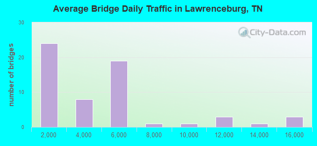
- 228,432Total average daily traffic
- 15,639Total average daily truck traffic
- National Bridge Inventory (NBI) Registered Bridges for Lawrenceburg
- No street view available for this location
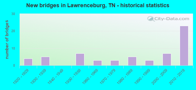
- New bridges - historical statistics
- 41920-1929
- 51930-1939
- 71950-1959
- 31960-1969
- 31970-1979
- 51980-1989
- 31990-1999
- 72000-2009
- 232010-2019
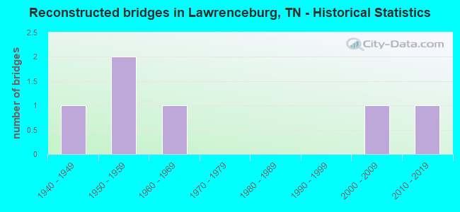
- Reconstructed bridges - Historical Statistics
- 11940-1949
- 21950-1959
- 11960-1969
- 01970-1979
- 01980-1989
- 01990-1999
- 12000-2009
- 12010-2019
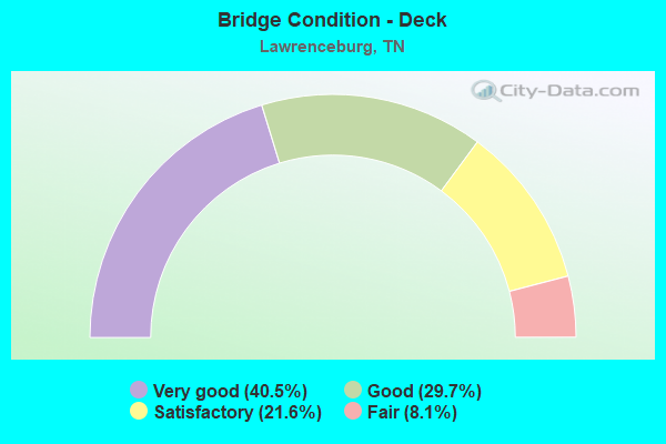
- Bridge Condition - Deck
- 40.5%Very good
- 29.7%Good
- 21.6%Satisfactory
- 8.1%Fair
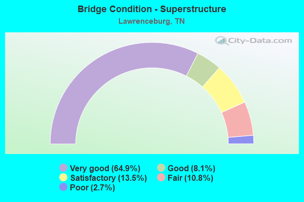
- Bridge Condition - Superstructure
- 64.9%Very good
- 8.1%Good
- 13.5%Satisfactory
- 10.8%Fair
- 2.7%Poor
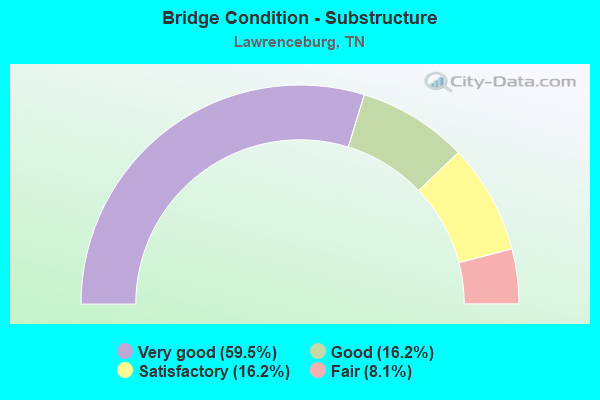
- Bridge Condition - Substructure
- 59.5%Very good
- 16.2%Good
- 16.2%Satisfactory
- 8.1%Fair
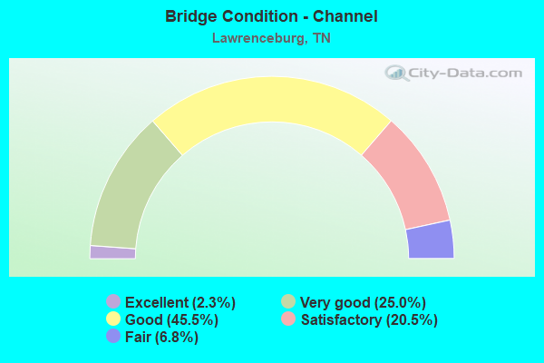
- Bridge Condition - Channel
- 2.3%Excellent
- 25.0%Very good
- 45.5%Good
- 20.5%Satisfactory
- 6.8%Fair
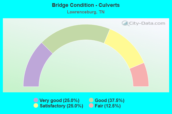
- Bridge Condition - Culverts
- 25.0%Very good
- 37.5%Good
- 25.0%Satisfactory
- 12.5%Fair
Find on map >> Show street view
Structure Number: 50SR0150019, Location: 2.5 MI.S.OF LAWRENCEBURG (Lat: 35.228322, Lng: -87.372217), Route carried "on" structure: US 64, Year Built: 2014, Status: Open, Structure Length: 17.07m (56.00ft), Average Daily Traffic: 4,158 (year 2020), Truck Traffic: 9%, Average Future Daily Traffic: 6,653 (year 2041), Design Load: HS 20, Features Intersected: POND CREEK
Minimum Vertical Clearance: 30+ m (98+ ft), Kilometerpoint: 24.012, Lanes on structure: 2, Base Highway Network: Yes, Owner: State Highway Agency, Approaching Roadway Width: 13.1m (43.0ft), Skew: 6 degrees, Material/Design: Steel continuous, Design/Construction: Stringer/Multi-beam, Number Of Spans In Main Unit: 3, Length of Maximum Span: 67.1m (220.1ft), Curb-To-Curb Width: 13.1m (43.0ft), Out-to-Out Width: 13.4m (44.0ft)
Condition: Deck: Very good, Superstructure: Very good, Substructure: Very good, Channel: Very good, Operating Rating: 34.7 metric tons, Method Used To Determine Operating Rating: Load and Resistance Factor Rating (LRFR) rating reported by rating factor(RF) method using HL-93 loadings, Inventory Rating: 26.9 metric tons, Method Used To Determine Inventory Rating: Load and Resistance Factor Rating (LRFR) rating reported by rating factor(RF) method using HL-93 loadings, Structural Evaluation: Equal to present minimum criteria, Deck Geometry: Superior to present desirable criteria, Waterway Adequacy: Equal to present desirable criteria, Approach Roadway Alignment: Equal to present desirable criteria, Designated Inspection Frequency: Every 24 months, Inspection Date: October 2020, Deck Structure Type: Concrete Cast-file-Place, Wearing Surface/Protective System: Deck Protection: Epoxy Coated Reinforcing
Find on map >> Show street view
Structure Number: 50SR015002, Location: 2.5 MI.S.OF LAWRENCEBURG (Lat: 35.228344, Lng: -87.371928), Route carried "on" structure: US 64, Year Built: 2014, Status: Open, Structure Length: 17.07m (56.00ft), Average Daily Traffic: 4,158 (year 2020), Truck Traffic: 9%, Average Future Daily Traffic: 6,736 (year 2041), Design Load: HS 20, Features Intersected: POND CREEK
Minimum Vertical Clearance: 30+ m (98+ ft), Kilometerpoint: 24.012, Lanes on structure: 2, Base Highway Network: Yes, Owner: State Highway Agency, Approaching Roadway Width: 13.1m (43.0ft), Skew: 6 degrees, Material/Design: Steel continuous, Design/Construction: Stringer/Multi-beam, Number Of Spans In Main Unit: 3, Length of Maximum Span: 67.1m (220.1ft), Curb-To-Curb Width: 13.1m (43.0ft), Out-to-Out Width: 13.4m (44.0ft)
Condition: Deck: Very good, Superstructure: Very good, Substructure: Very good, Channel: Very good, Operating Rating: 44.1 metric tons, Method Used To Determine Operating Rating: Assigned ratings based on Load and Resistance Factor Design (LRFD) reported by rating factor (RF) using HL93 loadings, Inventory Rating: 32.4 metric tons, Method Used To Determine Inventory Rating: Assigned ratings based on Load and Resistance Factor Design (LRFD) reported by rating factor (RF) using HL93 loadings, Structural Evaluation: Equal to present desirable criteria, Deck Geometry: Superior to present desirable criteria, Waterway Adequacy: Equal to present desirable criteria, Approach Roadway Alignment: Equal to present desirable criteria, Designated Inspection Frequency: Every 24 months, Inspection Date: October 2020, Deck Structure Type: Concrete Cast-file-Place, Wearing Surface/Protective System: Deck Protection: Epoxy Coated Reinforcing
Find on map >> Show street view
Structure Number: 50SR0150021, Location: 2.5 MI.S.OF LAWRENCEBURG (Lat: 35.215097, Lng: -87.364033), Route carried "on" structure: US 64, Year Built: 2014, Status: Open, Structure Length: 17.07m (56.00ft), Average Daily Traffic: 4,158 (year 2020), Truck Traffic: 9%, Average Future Daily Traffic: 6,736 (year 2041), Design Load: HS 20, Features Intersected: SHOAL CREEK
Minimum Vertical Clearance: 30+ m (98+ ft), Kilometerpoint: 25.685, Lanes on structure: 2, Base Highway Network: Yes, Owner: State Highway Agency, Approaching Roadway Width: 13.1m (43.0ft), Skew: 9 degrees, Material/Design: Steel continuous, Design/Construction: Stringer/Multi-beam, Number Of Spans In Main Unit: 3, Length of Maximum Span: 67.1m (220.1ft), Curb-To-Curb Width: 13.1m (43.0ft), Out-to-Out Width: 13.4m (44.0ft)
Condition: Deck: Very good, Superstructure: Very good, Substructure: Very good, Channel: Very good, Operating Rating: 44.1 metric tons, Method Used To Determine Operating Rating: Assigned ratings based on Load and Resistance Factor Design (LRFD) reported by rating factor (RF) using HL93 loadings, Inventory Rating: 32.4 metric tons, Method Used To Determine Inventory Rating: Assigned ratings based on Load and Resistance Factor Design (LRFD) reported by rating factor (RF) using HL93 loadings, Structural Evaluation: Equal to present desirable criteria, Deck Geometry: Superior to present desirable criteria, Waterway Adequacy: Equal to present desirable criteria, Approach Roadway Alignment: Equal to present desirable criteria, Designated Inspection Frequency: Every 24 months, Inspection Date: October 2020, Deck Structure Type: Concrete Cast-file-Place, Wearing Surface/Protective System: Deck Protection: Epoxy Coated Reinforcing
Find on map >> Show street view
Structure Number: 50SR0150022, Location: 2.5 MI.S.OF LAWRENCEBURG (Lat: 35.215192, Lng: -87.363767), Route carried "on" structure: US 64, Year Built: 2014, Status: Open, Structure Length: 17.07m (56.00ft), Average Daily Traffic: 4,158 (year 2020), Truck Traffic: 9%, Average Future Daily Traffic: 6,736 (year 2041), Design Load: HS 20, Features Intersected: SHOAL CREEK
Minimum Vertical Clearance: 30+ m (98+ ft), Kilometerpoint: 25.685, Lanes on structure: 2, Base Highway Network: Yes, Owner: State Highway Agency, Approaching Roadway Width: 13.1m (43.0ft), Skew: 9 degrees, Material/Design: Steel continuous, Design/Construction: Stringer/Multi-beam, Number Of Spans In Main Unit: 3, Length of Maximum Span: 67.1m (220.1ft), Curb-To-Curb Width: 13.1m (43.0ft), Out-to-Out Width: 13.4m (44.0ft)
Condition: Deck: Very good, Superstructure: Very good, Substructure: Very good, Channel: Very good, Operating Rating: 44.1 metric tons, Method Used To Determine Operating Rating: Assigned ratings based on Load and Resistance Factor Design (LRFD) reported by rating factor (RF) using HL93 loadings, Inventory Rating: 32.4 metric tons, Method Used To Determine Inventory Rating: Assigned ratings based on Load and Resistance Factor Design (LRFD) reported by rating factor (RF) using HL93 loadings, Structural Evaluation: Equal to present desirable criteria, Deck Geometry: Superior to present desirable criteria, Waterway Adequacy: Equal to present desirable criteria, Approach Roadway Alignment: Equal to present desirable criteria, Designated Inspection Frequency: Every 24 months, Inspection Date: October 2020, Deck Structure Type: Concrete Cast-file-Place, Wearing Surface/Protective System: Deck Protection: Epoxy Coated Reinforcing
Find on map >> Show street view
Structure Number: 50SR0150023, Location: 2.5 MI.S.OF LAWRENCEBURG (Lat: 35.205481, Lng: -87.341764), Route carried "on" structure: US 64, Year Built: 2014, Status: Open, Structure Length: 6.91m (22.67ft), Average Daily Traffic: 4,158 (year 2020), Truck Traffic: 9%, Average Future Daily Traffic: 6,736 (year 2041), Design Load: HS 20, Features Intersected: TN SOUTHERN RR
Minimum Vertical Clearance: 30+ m (98+ ft), Kilometerpoint: 28.260, Lanes on structure: 2, Base Highway Network: Yes, Owner: State Highway Agency, Approaching Roadway Width: 13.1m (43.0ft), Skew: 8 degrees, Material/Design: Prestressed concrete continuous, Design/Construction: Stringer/Multi-beam, Number Of Spans In Main Unit: 3, Length of Maximum Span: 23.1m (75.8ft), Curb-To-Curb Width: 13.1m (43.0ft), Out-to-Out Width: 13.4m (44.0ft)
Condition: Deck: Very good, Superstructure: Very good, Substructure: Very good, Operating Rating: 44.1 metric tons, Method Used To Determine Operating Rating: Assigned ratings based on Load and Resistance Factor Design (LRFD) reported by rating factor (RF) using HL93 loadings, Inventory Rating: 32.4 metric tons, Method Used To Determine Inventory Rating: Assigned ratings based on Load and Resistance Factor Design (LRFD) reported by rating factor (RF) using HL93 loadings, Structural Evaluation: Equal to present desirable criteria, Deck Geometry: Superior to present desirable criteria, Underclear: Superior to present desirable criteria, Approach Roadway Alignment: Equal to present desirable criteria, Designated Inspection Frequency: Every 24 months, Inspection Date: October 2020, Deck Structure Type: Concrete Cast-file-Place, Wearing Surface/Protective System: Deck Protection: Epoxy Coated Reinforcing
Find on map >> Show street view
Structure Number: 50SR0150024, Location: 2.5 MI.S.OF LAWRENCEBURG (Lat: 35.205694, Lng: -87.341803), Route carried "on" structure: US 64, Year Built: 2014, Status: Open, Structure Length: 6.91m (22.67ft), Average Daily Traffic: 4,158 (year 2020), Truck Traffic: 9%, Average Future Daily Traffic: 6,736 (year 2041), Design Load: HS 20, Features Intersected: TN SOUTHERN RR
Minimum Vertical Clearance: 30+ m (98+ ft), Kilometerpoint: 28.260, Lanes on structure: 2, Base Highway Network: Yes, Owner: State Highway Agency, Approaching Roadway Width: 13.1m (43.0ft), Skew: 8 degrees, Material/Design: Prestressed concrete continuous, Design/Construction: Stringer/Multi-beam, Number Of Spans In Main Unit: 3, Length of Maximum Span: 23.1m (75.8ft), Curb-To-Curb Width: 13.1m (43.0ft), Out-to-Out Width: 13.4m (44.0ft)
Condition: Deck: Very good, Superstructure: Very good, Substructure: Very good, Operating Rating: 44.1 metric tons, Method Used To Determine Operating Rating: Assigned ratings based on Load and Resistance Factor Design (LRFD) reported by rating factor (RF) using HL93 loadings, Inventory Rating: 32.4 metric tons, Method Used To Determine Inventory Rating: Assigned ratings based on Load and Resistance Factor Design (LRFD) reported by rating factor (RF) using HL93 loadings, Structural Evaluation: Equal to present desirable criteria, Deck Geometry: Superior to present desirable criteria, Underclear: Superior to present desirable criteria, Approach Roadway Alignment: Equal to present desirable criteria, Designated Inspection Frequency: Every 24 months, Inspection Date: October 2020, Deck Structure Type: Concrete Cast-file-Place, Wearing Surface/Protective System: Deck Protection: Epoxy Coated Reinforcing
Find on map >> Show street view
Structure Number: 50SR0150025, Location: 2.5 MI.S.OF LAWRENCEBURG (Lat: 35.205250, Lng: -87.341719), Route carried "on" structure: Ramp US 64, Year Built: 2014, Status: Open, Structure Length: 5.77m (18.93ft), Average Daily Traffic: 4,158 (year 2020), Truck Traffic: 9%, Average Future Daily Traffic: 6,736 (year 2041), Design Load: HS 20, Features Intersected: TN SOUTHERN RR
Minimum Vertical Clearance: 30+ m (98+ ft), Kilometerpoint: 28.260, Lanes on structure: 1, Base Highway Network: Yes, Owner: State Highway Agency, Approaching Roadway Width: 10.6m (34.8ft), Skew: 6 degrees, Material/Design: Prestressed concrete continuous, Design/Construction: Stringer/Multi-beam, Number Of Spans In Main Unit: 3, Length of Maximum Span: 21.3m (69.9ft), Curb-To-Curb Width: 9.4m (30.8ft), Out-to-Out Width: 9.8m (32.2ft)
Condition: Deck: Very good, Superstructure: Very good, Substructure: Very good, Operating Rating: 44.1 metric tons, Method Used To Determine Operating Rating: Assigned ratings based on Load and Resistance Factor Design (LRFD) reported by rating factor (RF) using HL93 loadings, Inventory Rating: 32.4 metric tons, Method Used To Determine Inventory Rating: Assigned ratings based on Load and Resistance Factor Design (LRFD) reported by rating factor (RF) using HL93 loadings, Structural Evaluation: Equal to present desirable criteria, Deck Geometry: Superior to present desirable criteria, Underclear: Superior to present desirable criteria, Approach Roadway Alignment: Equal to present desirable criteria, Designated Inspection Frequency: Every 24 months, Inspection Date: October 2020, Deck Structure Type: Concrete Cast-file-Place, Wearing Surface/Protective System: Deck Protection: Epoxy Coated Reinforcing
Find on map >> Show street view
Structure Number: 50SR0150027, Location: 2.5 MI.E.OF LAWRENCEBURG (Lat: 35.220133, Lng: -87.264300), Route carried "on" structure: US 64, Year Built: 2007, Status: Open, Structure Length: 5.49m (18.01ft), Average Daily Traffic: 5,187 (year 2020), Truck Traffic: 9%, Average Future Daily Traffic: 8,299 (year 2041), Design Load: HS 20, Features Intersected: BRANCH, Facility Carried by Structure: FAP 15
Minimum Vertical Clearance: 30+ m (98+ ft), Kilometerpoint: 35.977, Lanes on structure: 3, Base Highway Network: Yes, Owner: State Highway Agency, Approaching Roadway Width: 13.0m (42.7ft), Material/Design: Prestressed concrete continuous, Design/Construction: Box Beam or Girders - Single/Spread, Number Of Spans In Main Unit: 3, Length of Maximum Span: 18.1m (59.4ft), Curb-To-Curb Width: 16.5m (54.1ft), Out-to-Out Width: 17.1m (56.1ft)
Condition: Deck: Very good, Superstructure: Very good, Substructure: Very good, Channel: Very good, Operating Rating: 58.7 metric tons, Method Used To Determine Operating Rating: Load Factor (LF), Inventory Rating: 32.4 metric tons, Method Used To Determine Inventory Rating: Load Factor (LF), Structural Evaluation: Equal to present desirable criteria, Deck Geometry: Better than present minimum criteria, Waterway Adequacy: Equal to present desirable criteria, Approach Roadway Alignment: Equal to present desirable criteria, Designated Inspection Frequency: Every 24 months, Inspection Date: April 2021, Deck Structure Type: Concrete Cast-file-Place, Wearing Surface/Protective System: Wearing Surface: Monolithic Concrete, Deck Protection: Epoxy Coated Reinforcing
Find on map >> Show street view
Structure Number: 50SR0150028, Location: 2.5 MI.E.OF LAWRENCEBURG (Lat: 35.220350, Lng: -87.264350), Route carried "on" structure: US 64, Year Built: 2007, Status: Open, Structure Length: 5.49m (18.01ft), Average Daily Traffic: 5,187 (year 2020), Truck Traffic: 9%, Average Future Daily Traffic: 8,299 (year 2041), Design Load: HS 20, Features Intersected: BRANCH, Facility Carried by Structure: FAP 15
Minimum Vertical Clearance: 30+ m (98+ ft), Kilometerpoint: 35.977, Lanes on structure: 2, Base Highway Network: Yes, Owner: State Highway Agency, Approaching Roadway Width: 13.0m (42.7ft), Material/Design: Prestressed concrete continuous, Design/Construction: Box Beam or Girders - Single/Spread, Number Of Spans In Main Unit: 3, Length of Maximum Span: 18.1m (59.4ft), Curb-To-Curb Width: 13.0m (42.7ft), Out-to-Out Width: 13.4m (44.0ft)
Condition: Deck: Very good, Superstructure: Very good, Substructure: Very good, Channel: Very good, Operating Rating: 58.6 metric tons, Method Used To Determine Operating Rating: Load Factor (LF), Inventory Rating: 32.4 metric tons, Method Used To Determine Inventory Rating: Load Factor (LF), Structural Evaluation: Equal to present desirable criteria, Deck Geometry: Superior to present desirable criteria, Waterway Adequacy: Equal to present desirable criteria, Approach Roadway Alignment: Equal to present desirable criteria, Designated Inspection Frequency: Every 24 months, Inspection Date: April 2021, Deck Structure Type: Concrete Cast-file-Place, Wearing Surface/Protective System: Wearing Surface: Monolithic Concrete, Deck Protection: Epoxy Coated Reinforcing
Find on map >> Show street view
Structure Number: 50SR0150029, Location: 2.5 MI.E.OF LAWRENCEBURG (Lat: 35.220417, Lng: -87.255800), Route carried "on" structure: US 64, Year Built: 2009, Status: Open, Structure Length: 1.61m (5.28ft), Average Daily Traffic: 5,187 (year 2020), Truck Traffic: 9%, Average Future Daily Traffic: 8,299 (year 2041), Design Load: HS 20, Features Intersected: BRANCH, Facility Carried by Structure: FAP 15
Minimum Vertical Clearance: 30+ m (98+ ft), Kilometerpoint: 36.750, Lanes on structure: 4, Base Highway Network: Yes, Owner: State Highway Agency, Approaching Roadway Width: 17.1m (56.1ft), Skew: 4 degrees, Material/Design: Concrete continuous, Design/Construction: Culvert, Number Of Spans In Main Unit: 3, Length of Maximum Span: 3.6m (11.8ft)
Condition: Channel: Good, Culverts: Good, Operating Rating: 44.1 metric tons, Method Used To Determine Operating Rating: Assigned ratings based on Load and Resistance Factor Design (LRFD) reported by rating factor (RF) using HL93 loadings, Inventory Rating: 32.4 metric tons, Method Used To Determine Inventory Rating: Assigned ratings based on Load and Resistance Factor Design (LRFD) reported by rating factor (RF) using HL93 loadings, Structural Evaluation: Better than present minimum criteria, Waterway Adequacy: Equal to present desirable criteria, Approach Roadway Alignment: Equal to present desirable criteria, Length Of Structure Improvement: 1.61m (5.28ft), Designated Inspection Frequency: Every 24 months, Inspection Date: April 2021, Bridge Improvement Cost: $477,000, Roadway Improvement Cost: $48,000, Total Project Cost: $716,000 ( Estimate for 2021)
Find on map >> Show street view
Structure Number: 50SR0150033, Location: 1 MI.SE.OF SR-240 (Lat: 35.293253, Lng: -87.417078), Route carried "on" structure: US 64, Year Built: 2012, Status: Open, Structure Length: 1.44m (4.72ft), Average Daily Traffic: 4,530 (year 2020), Truck Traffic: 11%, Average Future Daily Traffic: 7,248 (year 2041), Design Load: HS 20, Features Intersected: BRANCH, Facility Carried by Structure: FAP 15
Minimum Vertical Clearance: 30+ m (98+ ft), Kilometerpoint: 15.257, Lanes on structure: 4, Base Highway Network: Yes, Owner: State Highway Agency, Approaching Roadway Width: 23.8m (78.1ft), Skew: 24 degrees, Material/Design: Concrete continuous, Design/Construction: Culvert, Number Of Spans In Main Unit: 2, Length of Maximum Span: 7.2m (23.6ft)
Condition: Channel: Very good, Culverts: Very good, Operating Rating: 54.1 metric tons, Method Used To Determine Operating Rating: Assigned ratings based on Load and Resistance Factor Design (LRFD) reported by rating factor (RF) using HL93 loadings, Inventory Rating: 32.4 metric tons, Method Used To Determine Inventory Rating: Assigned ratings based on Load and Resistance Factor Design (LRFD) reported by rating factor (RF) using HL93 loadings, Structural Evaluation: Equal to present desirable criteria, Waterway Adequacy: Equal to present desirable criteria, Approach Roadway Alignment: Equal to present desirable criteria, Length Of Structure Improvement: 1.44m (4.72ft), Designated Inspection Frequency: Every 24 months, Inspection Date: April 2021, Bridge Improvement Cost: $482,000, Roadway Improvement Cost: $49,000, Total Project Cost: $724,000 ( Estimate for 2021)
Find on map >> Show street view
Structure Number: 50SR0150035, Location: 1 MI.SE.OF SR-240 (Lat: 35.286300, Lng: -87.408583), Route carried "on" structure: US 64, Year Built: 2012, Status: Open, Structure Length: 1.16m (3.81ft), Average Daily Traffic: 5,460 (year 2020), Truck Traffic: 11%, Average Future Daily Traffic: 8,736 (year 2041), Design Load: HS 20, Features Intersected: BRANCH, Facility Carried by Structure: FAP 15
Minimum Vertical Clearance: 30+ m (98+ ft), Kilometerpoint: 16.391, Lanes on structure: 4, Base Highway Network: Yes, Owner: State Highway Agency, Approaching Roadway Width: 23.8m (78.1ft), Skew: 20 degrees, Material/Design: Concrete continuous, Design/Construction: Culvert, Number Of Spans In Main Unit: 3, Length of Maximum Span: 3.7m (12.1ft)
Condition: Channel: Very good, Culverts: Good, Operating Rating: 54.1 metric tons, Method Used To Determine Operating Rating: Assigned ratings based on Load and Resistance Factor Design (LRFD) reported by rating factor (RF) using HL93 loadings, Inventory Rating: 32.4 metric tons, Method Used To Determine Inventory Rating: Assigned ratings based on Load and Resistance Factor Design (LRFD) reported by rating factor (RF) using HL93 loadings, Structural Evaluation: Better than present minimum criteria, Waterway Adequacy: Equal to present desirable criteria, Approach Roadway Alignment: Equal to present desirable criteria, Length Of Structure Improvement: 1.16m (3.81ft), Designated Inspection Frequency: Every 24 months, Inspection Date: April 2021, Bridge Improvement Cost: $386,000, Roadway Improvement Cost: $39,000, Total Project Cost: $580,000 ( Estimate for 2021)
Find on map >> Show street view
Structure Number: 50SR0150037, Location: 1 MI.SE.OF SR-240 (Lat: 35.265739, Lng: -87.383742), Route carried "on" structure: US 64, Year Built: 2012, Status: Open, Structure Length: 1.42m (4.66ft), Average Daily Traffic: 2,815 (year 2020), Truck Traffic: 9%, Average Future Daily Traffic: 4,504 (year 2041), Design Load: HS 20, Features Intersected: BRANCH, Facility Carried by Structure: FAP 15
Minimum Vertical Clearance: 30+ m (98+ ft), Kilometerpoint: 19.481, Lanes on structure: 4, Base Highway Network: Yes, Owner: State Highway Agency, Approaching Roadway Width: 45.1m (148.0ft), Skew: 24 degrees, Material/Design: Concrete continuous, Design/Construction: Culvert, Number Of Spans In Main Unit: 2, Length of Maximum Span: 6.7m (22.0ft)
Condition: Channel: Very good, Culverts: Very good, Operating Rating: 54.1 metric tons, Method Used To Determine Operating Rating: Assigned ratings based on Load and Resistance Factor Design (LRFD) reported by rating factor (RF) using HL93 loadings, Inventory Rating: 32.4 metric tons, Method Used To Determine Inventory Rating: Assigned ratings based on Load and Resistance Factor Design (LRFD) reported by rating factor (RF) using HL93 loadings, Structural Evaluation: Equal to present desirable criteria, Waterway Adequacy: Equal to present desirable criteria, Approach Roadway Alignment: Equal to present desirable criteria, Length Of Structure Improvement: 1.42m (4.66ft), Designated Inspection Frequency: Every 24 months, Inspection Date: April 2021, Bridge Improvement Cost: $451,000, Roadway Improvement Cost: $46,000, Total Project Cost: $677,000 ( Estimate for 2021)
Find on map >> Show street view
Structure Number: 500A2450001, Location: 0.01 M.W.SR6-LAWRENCEBERG (Lat: 35.233900, Lng: -87.333533), Route carried "under" structure: City street 245, Year Built: 1950, Structure Length: 0. m, Average Daily Traffic: 1,210 (year 2022), Truck Traffic: 5%, Features Intersected: TS RR / NFA A245, Facility Carried by Structure: TS RR 350754C
Minimum Vertical Clearance: 7.26m (23.82ft), Kilometerpoint: 0.043, Lanes under structure: 2, Material/Design: Steel, Design/Construction: Stringer/Multi-beam, Length of Maximum Span: 32.0m (105.0ft)
Find on map >> Show street view
Structure Number: 50SR0060025, Location: 2.5 MI. S.OF LAWRENCEBURG (Lat: 35.205583, Lng: -87.339500), Route carried "under" structure: US 43, Year Built: 2014, Structure Length: 0. m, Average Daily Traffic: 14,262 (year 2020), Truck Traffic: 9%, Features Intersected: (US 64)
Minimum Vertical Clearance: 5.16m (16.93ft), Kilometerpoint: 29.000, Lanes on structure: 20, Lanes under structure: 40, Material/Design: Prestressed concrete continuous, Design/Construction: Stringer/Multi-beam, Length of Maximum Span: 39.8m (130.6ft)
Find on map >> Show street view
Structure Number: 50SR0060026, Location: 2.5 MI. S.OF LAWRENCEBURG (Lat: 35.205583, Lng: -87.339500), Route carried "under" structure: US 43, Year Built: 2014, Structure Length: 0. m, Average Daily Traffic: 14,262 (year 2020), Truck Traffic: 9%, Features Intersected: (US 64)
Minimum Vertical Clearance: 5.41m (17.75ft), Kilometerpoint: 29.000, Lanes on structure: 20, Lanes under structure: 40, Material/Design: Prestressed concrete continuous, Design/Construction: Stringer/Multi-beam, Length of Maximum Span: 39.8m (130.6ft)
Find on map >> Show street view
Structure Number: 50SR0150017, Location: 2.5 MI. S.OF LAWRENCEBURG (Lat: 35.242014, Lng: -87.376319), Route carried "under" structure: State highway 242, Year Built: 2014, Structure Length: 0. m, Average Daily Traffic: 3,336 (year 2020), Truck Traffic: 3%, Features Intersected: (US 64)
Minimum Vertical Clearance: 5.16m (16.93ft), Kilometerpoint: 35.776, Lanes on structure: 20, Lanes under structure: 20, Material/Design: Prestressed concrete continuous, Design/Construction: Stringer/Multi-beam, Length of Maximum Span: 28.3m (92.8ft)
Find on map >> Show street view
Structure Number: 50SR0150018, Location: 2.4 MI. W.OF LAWRENCEBURG (Lat: 35.242067, Lng: -87.376075), Route carried "under" structure: US 242, Year Built: 2014, Structure Length: 0. m, Average Daily Traffic: 3,336 (year 2020), Truck Traffic: 3%, Features Intersected: (US 64)
Minimum Vertical Clearance: 5.79m (19.00ft), Kilometerpoint: 35.776, Lanes on structure: 20, Lanes under structure: 20, Material/Design: Prestressed concrete continuous, Design/Construction: Stringer/Multi-beam, Length of Maximum Span: 28.4m (93.2ft)
Find on map >> Show street view
Structure Number: 50SR0150021, Location: 2.4 MI. W.OF LAWRENCEBURG (Lat: 35.215097, Lng: -87.364033), Route carried "under" structure: County highway A399, Year Built: 2014, Structure Length: 0. m, Average Daily Traffic: 50 (year 2018), Features Intersected: (US 64)
Minimum Vertical Clearance: 14.12m (46.33ft), Kilometerpoint: 1.223, Lanes on structure: 20, Lanes under structure: 20, Material/Design: Steel continuous, Design/Construction: Stringer/Multi-beam, Length of Maximum Span: 67.1m (220.1ft)
Find on map >> Show street view
Structure Number: 50SR0150022, Location: 2.4 MI. W.OF LAWRENCEBURG (Lat: 35.215192, Lng: -87.363767), Route carried "under" structure: County highway A399, Year Built: 2014, Structure Length: 0. m, Average Daily Traffic: 50 (year 2018), Features Intersected: (US 64)
Minimum Vertical Clearance: 14.12m (46.33ft), Kilometerpoint: 1.247, Lanes on structure: 20, Lanes under structure: 20, Material/Design: Steel continuous, Design/Construction: Stringer/Multi-beam, Length of Maximum Span: 67.1m (220.1ft)