Bridge Statistics for Lawrence, Massachusetts (MA)
Condition, Traffic, Stress, Structural Evaluation, Project Costs
- National Bridge Inventory (NBI) Statistics
- 72Number of bridges
- 1,224ft / 373mTotal length
- $402,044,000Total costs
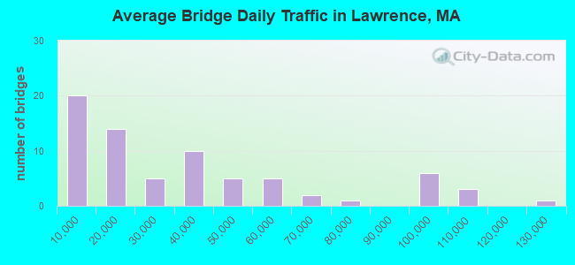
- 2,480,461Total average daily traffic
- 191,714Total average daily truck traffic
- National Bridge Inventory (NBI) Registered Bridges for Lawrence
- No street view available for this location
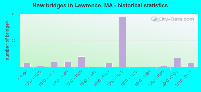
- New bridges - historical statistics
- 3Before 1900
- 11900-1909
- 41910-1919
- 41920-1929
- 81930-1939
- 31950-1959
- 381960-1969
- 11990-1999
- 72000-2009
- 32010-2019
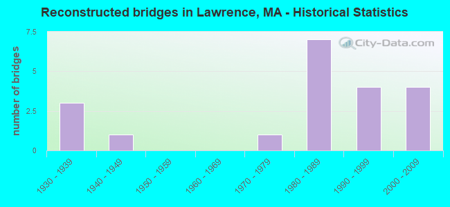
- Reconstructed bridges - Historical Statistics
- 31930-1939
- 11940-1949
- 01950-1959
- 01960-1969
- 11970-1979
- 71980-1989
- 41990-1999
- 42000-2009
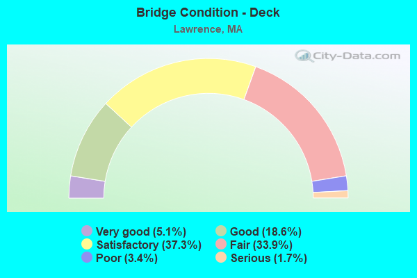
- Bridge Condition - Deck
- 5.1%Very good
- 18.6%Good
- 37.3%Satisfactory
- 33.9%Fair
- 3.4%Poor
- 1.7%Serious
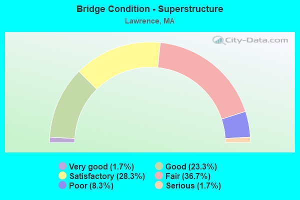
- Bridge Condition - Superstructure
- 1.7%Very good
- 23.3%Good
- 28.3%Satisfactory
- 36.7%Fair
- 8.3%Poor
- 1.7%Serious
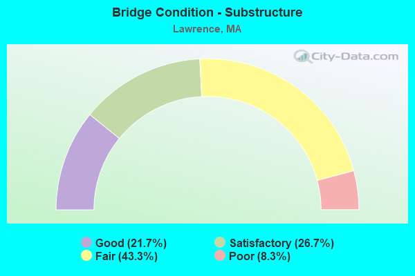
- Bridge Condition - Substructure
- 21.7%Good
- 26.7%Satisfactory
- 43.3%Fair
- 8.3%Poor
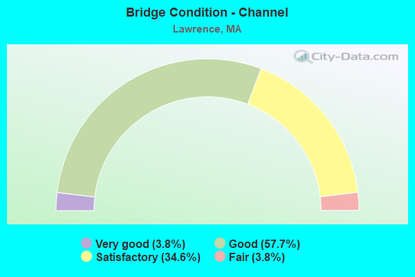
- Bridge Condition - Channel
- 3.8%Very good
- 57.7%Good
- 34.6%Satisfactory
- 3.8%Fair
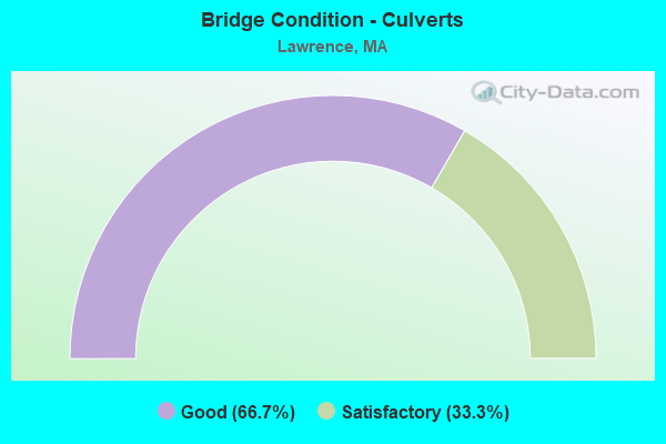
- Bridge Condition - Culverts
- 66.7%Good
- 33.3%Satisfactory
Find on map >> Show street view
Structure Number: A09027632DOTNBI, Location: .3 MILES S.OF I495 (Lat: 42.659472, Lng: -71.192125), Route carried "on" structure: State highway , Year Built: 2008, Status: Open, Structure Length: 7.17m (23.52ft), Average Daily Traffic: 3,232 (year 2018), Truck Traffic: 16%, Average Future Daily Traffic: 6,317 (year 2031), Design Load: HS 20, Features Intersected: I 93, Facility Carried by Structure: HWY HIGH PLN RD
Minimum Vertical Clearance: 30+ m (98+ ft), Kilometerpoint: 2.092, Lanes on structure: 2, Lanes under structure: 6, Owner: State Highway Agency, Approaching Roadway Width: 12.5m (41.0ft), Skew: 2 degrees, Material/Design: Prestressed concrete continuous, Design/Construction: Stringer/Multi-beam, Number Of Spans In Main Unit: 2, Length of Maximum Span: 33.6m (110.2ft), Curb or Sidewalk Widths: Left: 1.5m (4.9ft), Right: 0.0m, Curb-To-Curb Width: 12.5m (41.0ft), Out-to-Out Width: 14.8m (48.6ft)
Condition: Deck: Good, Superstructure: Good, Substructure: Good, Operating Rating: 91.8 metric tons, Method Used To Determine Operating Rating: Load Factor (LF), Inventory Rating: 55.0 metric tons, Method Used To Determine Inventory Rating: Load Factor (LF), Structural Evaluation: Better than present minimum criteria, Deck Geometry: Equal to present minimum criteria, Underclear: Equal to present minimum criteria, Approach Roadway Alignment: Better than present minimum criteria, Length Of Structure Improvement: 7.20m (23.62ft), Designated Inspection Frequency: Every 24 months, Inspection Date: September 2020, Bridge Improvement Cost: $611,000, Roadway Improvement Cost: $62,000, Total Project Cost: $917,000 ( Estimate for 2022), Deck Structure Type: Concrete Cast-file-Place, Wearing Surface/Protective System: Wearing Surface: Bituminous, Membrane: Other, Deck Protection: Epoxy Coated Reinforcing
Find on map >> Show street view
Structure Number: A090282YYDOTNBI, Location: NORTH I 495 (Lat: 42.677311, Lng: -71.200303), Route carried "on" structure: State highway , Year Built: 1959, Status: Open, Structure Length: 9.75m (31.99ft), Average Daily Traffic: 3,954 (year 2016), Truck Traffic: 8%, Average Future Daily Traffic: 3,159 (year 2031), Design Load: H 20, Features Intersected: I 93, Facility Carried by Structure: HWY CHANDLER RD
Minimum Vertical Clearance: 30+ m (98+ ft), Kilometerpoint: 1.287, Lanes on structure: 2, Lanes under structure: 6, Owner: State Highway Agency, Approaching Roadway Width: 9.7m (31.8ft), Skew: 5 degrees, Material/Design: Steel continuous, Design/Construction: Stringer/Multi-beam, Number Of Spans In Main Unit: 4, Length of Maximum Span: 32.9m (107.9ft), Curb or Sidewalk Widths: Left: 0.0m, Right: 1.5m (4.9ft), Curb-To-Curb Width: 9.8m (32.2ft), Out-to-Out Width: 12.7m (41.7ft)
Condition: Deck: Fair, Superstructure: Poor, Substructure: Fair, Operating Rating: 56.3 metric tons, Method Used To Determine Operating Rating: Load Factor (LF), Inventory Rating: 33.7 metric tons, Method Used To Determine Inventory Rating: Load Factor (LF), Structural Evaluation: Meets minimum limits, Deck Geometry: Meets minimum limits, Underclear: High priority of corrective action, Approach Roadway Alignment: Equal to present desirable criteria, Length Of Structure Improvement: 9.80m (32.15ft), Designated Inspection Frequency: Every 12 months, Other Special Inspection Frequency: Every 12 months, Inspection Date: March 2022, Other Special Inspection Date: March 2022, Bridge Improvement Cost: $4,889,000, Roadway Improvement Cost: $489,000, Total Project Cost: $7,334,000 ( Estimate for 2022), Deck Structure Type: Concrete Cast-file-Place, Wearing Surface/Protective System: Wearing Surface: Monolithic Concrete
Find on map >> Show street view
Structure Number: A090312XQDOTNBI, Location: JCT I-93 & I-495 (Lat: 42.664022, Lng: -71.194219), Route carried "on" structure: Interstate 495, Year Built: 1961, Year Reconstructed: 1992, Status: Open, Structure Length: 7.68m (25.20ft), Average Daily Traffic: 58,248 (year 2019), Truck Traffic: 6%, Average Future Daily Traffic: 84,335 (year 2033), Design Load: HS 20+Mod, Features Intersected: I 93
Minimum Vertical Clearance: 30+ m (98+ ft), Kilometerpoint: 156.295, Lanes on structure: 4, Lanes under structure: 6, Base Highway Network: Yes, Owner: State Highway Agency, Approaching Roadway Width: 17.4m (57.1ft), Skew: 2 degrees, Material/Design: Steel, Design/Construction: Stringer/Multi-beam, Number Of Spans In Main Unit: 4, Length of Maximum Span: 26.8m (87.9ft), Curb-To-Curb Width: 15.8m (51.8ft), Out-to-Out Width: 18.3m (60.0ft)
Condition: Deck: Satisfactory, Superstructure: Fair, Substructure: Fair, Operating Rating: 70.3 metric tons, Method Used To Determine Operating Rating: Load Factor (LF), Inventory Rating: 42.1 metric tons, Method Used To Determine Inventory Rating: Load Factor (LF), Structural Evaluation: Somewhat better than minimum adequacy, Deck Geometry: Meets minimum limits, Underclear: High priority of corrective action, Approach Roadway Alignment: Better than present minimum criteria, Length Of Structure Improvement: 7.70m (25.26ft), Designated Inspection Frequency: Every 24 months, Inspection Date: March 2020, Bridge Improvement Cost: $5,535,000, Roadway Improvement Cost: $554,000, Total Project Cost: $8,303,000 ( Estimate for 2022), Deck Structure Type: Concrete Cast-file-Place, Wearing Surface/Protective System: Wearing Surface: Bituminous, Membrane: Built-up, Deck Protection: Epoxy Coated Reinforcing
Find on map >> Show street view
Structure Number: A090312XRDOTNBI, Location: JCT I-93 & I-495 (Lat: 42.664433, Lng: -71.194419), Route carried "on" structure: Interstate 495, Year Built: 1961, Year Reconstructed: 1992, Status: Open, Structure Length: 7.68m (25.20ft), Average Daily Traffic: 59,694 (year 2019), Truck Traffic: 6%, Average Future Daily Traffic: 84,335 (year 2033), Design Load: HS 20+Mod, Features Intersected: I 93
Minimum Vertical Clearance: 30+ m (98+ ft), Kilometerpoint: 156.295, Lanes on structure: 4, Lanes under structure: 8, Base Highway Network: Yes, Owner: State Highway Agency, Approaching Roadway Width: 15.8m (51.8ft), Skew: 2 degrees, Material/Design: Steel, Design/Construction: Stringer/Multi-beam, Number Of Spans In Main Unit: 4, Length of Maximum Span: 26.8m (87.9ft), Curb-To-Curb Width: 15.8m (51.8ft), Out-to-Out Width: 18.3m (60.0ft)
Condition: Deck: Satisfactory, Superstructure: Fair, Substructure: Fair, Operating Rating: 70.3 metric tons, Method Used To Determine Operating Rating: Load Factor (LF), Inventory Rating: 42.1 metric tons, Method Used To Determine Inventory Rating: Load Factor (LF), Structural Evaluation: Somewhat better than minimum adequacy, Deck Geometry: Meets minimum limits, Underclear: Equal to present minimum criteria, Approach Roadway Alignment: Equal to present desirable criteria, Length Of Structure Improvement: 7.70m (25.26ft), Designated Inspection Frequency: Every 24 months, Inspection Date: March 2020, Bridge Improvement Cost: $5,535,000, Roadway Improvement Cost: $554,000, Total Project Cost: $8,303,000 ( Estimate for 2022), Deck Structure Type: Concrete Cast-file-Place, Wearing Surface/Protective System: Wearing Surface: Bituminous, Membrane: Built-up, Deck Protection: Epoxy Coated Reinforcing
Find on map >> Show street view
Structure Number: A09032300DOTNBI, Location: GREENWOOD AT I-495 (Lat: 42.667075, Lng: -71.189372), Route carried "on" structure: State highway , Year Built: 1962, Status: Open, Structure Length: 4.69m (15.39ft), Average Daily Traffic: 1,700 (year 2020), Truck Traffic: 4%, Average Future Daily Traffic: 2,685 (year 2033), Design Load: H 20, Features Intersected: I 495 NB, Facility Carried by Structure: HWY GREENWOOD RD
Minimum Vertical Clearance: 30+ m (98+ ft), Kilometerpoint: 2.049, Lanes on structure: 2, Lanes under structure: 3, Owner: State Highway Agency, Approaching Roadway Width: 9.8m (32.2ft), Skew: 2 degrees, Material/Design: Steel, Design/Construction: Stringer/Multi-beam, Number Of Spans In Main Unit: 3, Length of Maximum Span: 25.3m (83.0ft), Curb or Sidewalk Widths: Left: 0.0m, Right: 1.8m (5.9ft), Curb-To-Curb Width: 9.8m (32.2ft), Out-to-Out Width: 12.2m (40.0ft)
Condition: Deck: Fair, Superstructure: Fair, Substructure: Satisfactory, Operating Rating: 51.4 metric tons, Method Used To Determine Operating Rating: Load Factor (LF), Inventory Rating: 30.8 metric tons, Method Used To Determine Inventory Rating: Load Factor (LF), Structural Evaluation: Somewhat better than minimum adequacy, Deck Geometry: Somewhat better than minimum adequacy, Underclear: Equal to present minimum criteria, Approach Roadway Alignment: Equal to present desirable criteria, Length Of Structure Improvement: 4.70m (15.42ft), Designated Inspection Frequency: Every 24 months, Inspection Date: Febuary 2022, Bridge Improvement Cost: $2,253,000, Roadway Improvement Cost: $226,000, Total Project Cost: $3,380,000 ( Estimate for 2022), Deck Structure Type: Concrete Cast-file-Place, Wearing Surface/Protective System: Wearing Surface: Bituminous, Membrane: Built-up
Find on map >> Show street view
Structure Number: A09032301DOTNBI, Location: GREENWOOD AT I-495 (Lat: 42.667881, Lng: -71.189650), Route carried "on" structure: State highway , Year Built: 1962, Status: Open, Structure Length: 4.54m (14.90ft), Average Daily Traffic: 1,700 (year 2020), Truck Traffic: 4%, Average Future Daily Traffic: 2,685 (year 2033), Design Load: H 20, Features Intersected: I 495 SB, Facility Carried by Structure: HWY GREENWOOD RD
Minimum Vertical Clearance: 30+ m (98+ ft), Kilometerpoint: 2.049, Lanes on structure: 2, Lanes under structure: 3, Owner: State Highway Agency, Approaching Roadway Width: 9.8m (32.2ft), Skew: 2 degrees, Material/Design: Steel, Design/Construction: Stringer/Multi-beam, Number Of Spans In Main Unit: 3, Length of Maximum Span: 24.7m (81.0ft), Curb or Sidewalk Widths: Left: 0.0m, Right: 1.8m (5.9ft), Curb-To-Curb Width: 9.8m (32.2ft), Out-to-Out Width: 12.2m (40.0ft)
Condition: Deck: Satisfactory, Superstructure: Satisfactory, Substructure: Satisfactory, Operating Rating: 54.3 metric tons, Method Used To Determine Operating Rating: Load Factor (LF), Inventory Rating: 32.5 metric tons, Method Used To Determine Inventory Rating: Load Factor (LF), Structural Evaluation: Equal to present minimum criteria, Deck Geometry: Somewhat better than minimum adequacy, Underclear: High priority of corrective action, Approach Roadway Alignment: Equal to present desirable criteria, Length Of Structure Improvement: 4.60m (15.09ft), Designated Inspection Frequency: Every 24 months, Inspection Date: Febuary 2022, Bridge Improvement Cost: $1,562,000, Roadway Improvement Cost: $157,000, Total Project Cost: $2,344,000 ( Estimate for 2022), Deck Structure Type: Concrete Cast-file-Place, Wearing Surface/Protective System: Wearing Surface: Bituminous, Membrane: Built-up
Find on map >> Show street view
Structure Number: A09033302DOTNBI, Location: GREENWOOD AT I-495 (Lat: 42.671308, Lng: -71.180928), Route carried "on" structure: State highway , Year Built: 1962, Status: Open, Structure Length: 4.36m (14.30ft), Average Daily Traffic: 8,800 (year 2018), Truck Traffic: 7%, Average Future Daily Traffic: 12,161 (year 2033), Design Load: H 20, Features Intersected: I 495 NB, Facility Carried by Structure: HWY CHANDLER RD
Minimum Vertical Clearance: 30+ m (98+ ft), Kilometerpoint: 3.299, Lanes on structure: 2, Lanes under structure: 3, Owner: State Highway Agency, Approaching Roadway Width: 12.2m (40.0ft), Skew: 4 degrees, Material/Design: Steel, Design/Construction: Stringer/Multi-beam, Number Of Spans In Main Unit: 3, Length of Maximum Span: 22.2m (72.8ft), Curb or Sidewalk Widths: Left: 0.5m (1.6ft), Right: 1.5m (4.9ft), Curb-To-Curb Width: 12.2m (40.0ft), Out-to-Out Width: 14.9m (48.9ft)
Condition: Deck: Fair, Superstructure: Fair, Substructure: Fair, Operating Rating: 51.2 metric tons, Method Used To Determine Operating Rating: Load Factor (LF), Inventory Rating: 30.7 metric tons, Method Used To Determine Inventory Rating: Load Factor (LF), Structural Evaluation: Somewhat better than minimum adequacy, Deck Geometry: Somewhat better than minimum adequacy, Underclear: High priority of corrective action, Approach Roadway Alignment: Equal to present desirable criteria, Length Of Structure Improvement: 4.40m (14.44ft), Designated Inspection Frequency: Every 24 months, Inspection Date: Febuary 2022, Bridge Improvement Cost: $2,576,000, Roadway Improvement Cost: $258,000, Total Project Cost: $3,865,000 ( Estimate for 2022), Deck Structure Type: Concrete Cast-file-Place, Wearing Surface/Protective System: Wearing Surface: Bituminous, Membrane: Built-up
Find on map >> Show street view
Structure Number: A09033303DOTNBI, Location: CHANDLER RD AT I-495 (Lat: 42.672089, Lng: -71.181514), Route carried "on" structure: State highway , Year Built: 1962, Status: Open, Structure Length: 4.62m (15.16ft), Average Daily Traffic: 8,800 (year 2018), Truck Traffic: 7%, Average Future Daily Traffic: 12,161 (year 2033), Design Load: H 20, Features Intersected: I 495 SB, Facility Carried by Structure: HWY CHANDLER RD
Minimum Vertical Clearance: 30+ m (98+ ft), Kilometerpoint: 3.291, Lanes on structure: 2, Lanes under structure: 3, Owner: State Highway Agency, Approaching Roadway Width: 12.2m (40.0ft), Skew: 4 degrees, Material/Design: Steel, Design/Construction: Stringer/Multi-beam, Number Of Spans In Main Unit: 3, Length of Maximum Span: 22.1m (72.5ft), Curb or Sidewalk Widths: Left: 0.5m (1.6ft), Right: 1.5m (4.9ft), Curb-To-Curb Width: 12.2m (40.0ft), Out-to-Out Width: 14.9m (48.9ft)
Condition: Deck: Fair, Superstructure: Fair, Substructure: Good, Operating Rating: 73.9 metric tons, Method Used To Determine Operating Rating: Load Factor (LF), Inventory Rating: 50.9 metric tons, Method Used To Determine Inventory Rating: Load Factor (LF), Structural Evaluation: Somewhat better than minimum adequacy, Deck Geometry: Somewhat better than minimum adequacy, Underclear: Meets minimum limits, Approach Roadway Alignment: Equal to present desirable criteria, Length Of Structure Improvement: 4.70m (15.42ft), Designated Inspection Frequency: Every 24 months, Inspection Date: Febuary 2022, Bridge Improvement Cost: $2,751,000, Roadway Improvement Cost: $276,000, Total Project Cost: $4,127,000 ( Estimate for 2022), Deck Structure Type: Concrete Cast-file-Place, Wearing Surface/Protective System: Wearing Surface: Monolithic Concrete
Find on map >> Show street view
Structure Number: A090342XTDOTNBI, Location: 1.4 MI N I93 (Lat: 42.674789, Lng: -71.172197), Route carried "on" structure: Interstate 495, Year Built: 1962, Status: Open, Structure Length: 3.35m (10.99ft), Average Daily Traffic: 57,650 (year 2018), Truck Traffic: 10%, Average Future Daily Traffic: 153,508 (year 2033), Design Load: HS 20+Mod, Features Intersected: HWY BEACON ST
Minimum Vertical Clearance: 30+ m (98+ ft), Kilometerpoint: 158.505, Lanes on structure: 3, Lanes under structure: 2, Base Highway Network: Yes, Owner: State Highway Agency, Approaching Roadway Width: 15.2m (49.9ft), Skew: 2 degrees, Material/Design: Steel, Design/Construction: Stringer/Multi-beam, Number Of Spans In Main Unit: 3, Length of Maximum Span: 15.2m (49.9ft), Curb-To-Curb Width: 15.2m (49.9ft), Out-to-Out Width: 17.1m (56.1ft)
Condition: Deck: Satisfactory, Superstructure: Fair, Substructure: Fair, Operating Rating: 56.5 metric tons, Method Used To Determine Operating Rating: Load Factor (LF), Inventory Rating: 33.8 metric tons, Method Used To Determine Inventory Rating: Load Factor (LF), Structural Evaluation: Somewhat better than minimum adequacy, Deck Geometry: Meets minimum limits, Underclear: Meets minimum limits, Approach Roadway Alignment: Equal to present desirable criteria, Length Of Structure Improvement: 3.40m (11.15ft), Designated Inspection Frequency: Every 24 months, Inspection Date: Febuary 2022, Bridge Improvement Cost: $2,284,000, Roadway Improvement Cost: $229,000, Total Project Cost: $3,427,000 ( Estimate for 2022), Deck Structure Type: Concrete Cast-file-Place, Wearing Surface/Protective System: Wearing Surface: Bituminous, Membrane: Built-up
Find on map >> Show street view
Structure Number: A090342XUDOTNBI, Location: 1.4 MI N I-93 (Lat: 42.675119, Lng: -71.172153), Route carried "on" structure: Interstate 495, Year Built: 1962, Status: Open, Structure Length: 3.29m (10.79ft), Average Daily Traffic: 76,550 (year 2020), Truck Traffic: 9%, Average Future Daily Traffic: 153,508 (year 2033), Design Load: HS 20+Mod, Features Intersected: HWY BEACON ST
Minimum Vertical Clearance: 30+ m (98+ ft), Kilometerpoint: 158.275, Lanes on structure: 3, Lanes under structure: 2, Base Highway Network: Yes, Owner: State Highway Agency, Approaching Roadway Width: 15.2m (49.9ft), Skew: 2 degrees, Material/Design: Steel, Design/Construction: Stringer/Multi-beam, Number Of Spans In Main Unit: 3, Length of Maximum Span: 15.2m (49.9ft), Curb-To-Curb Width: 15.2m (49.9ft), Out-to-Out Width: 17.1m (56.1ft)
Condition: Deck: Satisfactory, Superstructure: Fair, Substructure: Fair, Operating Rating: 56.5 metric tons, Method Used To Determine Operating Rating: Load Factor (LF), Inventory Rating: 33.8 metric tons, Method Used To Determine Inventory Rating: Load Factor (LF), Structural Evaluation: Somewhat better than minimum adequacy, Deck Geometry: Meets minimum limits, Underclear: Meets minimum limits, Approach Roadway Alignment: Equal to present desirable criteria, Length Of Structure Improvement: 3.30m (10.83ft), Designated Inspection Frequency: Every 24 months, Inspection Date: Febuary 2022, Bridge Improvement Cost: $2,217,000, Roadway Improvement Cost: $222,000, Total Project Cost: $3,326,000 ( Estimate for 2022), Deck Structure Type: Concrete Cast-file-Place, Wearing Surface/Protective System: Wearing Surface: Bituminous, Membrane: Built-up
Find on map >> Show street view
Structure Number: A09035305DOTNBI, Location: 2 MI N I93 (Lat: 42.677158, Lng: -71.160556), Route carried "on" structure: State highway , Year Built: 1962, Status: Open, Structure Length: 5.39m (17.68ft), Average Daily Traffic: 2,600 (year 2018), Truck Traffic: 6%, Average Future Daily Traffic: 2,448 (year 2031), Design Load: H 20, Features Intersected: I 495, Facility Carried by Structure: HWY CORBETT ST
Minimum Vertical Clearance: 30+ m (98+ ft), Kilometerpoint: 0.177, Lanes on structure: 2, Lanes under structure: 6, Owner: State Highway Agency, Approaching Roadway Width: 9.8m (32.2ft), Skew: 1 degrees, Material/Design: Steel continuous, Design/Construction: Stringer/Multi-beam, Number Of Spans In Main Unit: 2, Length of Maximum Span: 26.5m (86.9ft), Curb or Sidewalk Widths: Left: 0.9m (3.0ft), Right: 1.5m (4.9ft), Curb-To-Curb Width: 9.8m (32.2ft), Out-to-Out Width: 12.5m (41.0ft)
Condition: Deck: Satisfactory, Superstructure: Satisfactory, Substructure: Satisfactory, Operating Rating: 52.3 metric tons, Method Used To Determine Operating Rating: Load Factor (LF), Inventory Rating: 31.3 metric tons, Method Used To Determine Inventory Rating: Load Factor (LF), Structural Evaluation: Equal to present minimum criteria, Deck Geometry: Meets minimum limits, Underclear: High priority of corrective action, Approach Roadway Alignment: Equal to present desirable criteria, Length Of Structure Improvement: 5.40m (17.72ft), Designated Inspection Frequency: Every 24 months, Inspection Date: November 2020, Bridge Improvement Cost: $2,652,000, Roadway Improvement Cost: $266,000, Total Project Cost: $3,979,000 ( Estimate for 2022), Deck Structure Type: Concrete Cast-file-Place, Wearing Surface/Protective System: Wearing Surface: Bituminous, Membrane: Built-up
Find on map >> Show street view
Structure Number: A090362XVDOTNBI, Location: 2.4 MI N I93 (Lat: 42.679219, Lng: -71.152856), Route carried "on" structure: Interstate 495, Year Built: 1962, Status: Temporarily open, Structure Length: 3.56m (11.68ft), Average Daily Traffic: 95,100 (year 2018), Truck Traffic: 10%, Average Future Daily Traffic: 150,191 (year 2033), Design Load: HS 20+Mod, Features Intersected: ST 28 SB/N MAIN ST
Minimum Vertical Clearance: 30+ m (98+ ft), Kilometerpoint: 160.162, Lanes on structure: 4, Lanes under structure: 2, Base Highway Network: Yes, Owner: State Highway Agency, Approaching Roadway Width: 15.8m (51.8ft), Skew: 1 degrees, Material/Design: Steel, Design/Construction: Stringer/Multi-beam, Number Of Spans In Main Unit: 3, Length of Maximum Span: 15.5m (50.9ft), Curb-To-Curb Width: 15.8m (51.8ft), Out-to-Out Width: 18.3m (60.0ft)
Condition: Deck: Fair, Superstructure: Satisfactory, Substructure: Poor, Operating Rating: 58.1 metric tons, Method Used To Determine Operating Rating: Load Factor (LF), Inventory Rating: 34.8 metric tons, Method Used To Determine Inventory Rating: Load Factor (LF), Structural Evaluation: Meets minimum limits, Deck Geometry: High priority of replacement, Underclear: Meets minimum limits, Approach Roadway Alignment: Equal to present desirable criteria, Length Of Structure Improvement: 3.60m (11.81ft), Designated Inspection Frequency: Every 12 months, Other Special Inspection Frequency: Every 12 months, Inspection Date: Febuary 2022, Other Special Inspection Date: Febuary 2022, Bridge Improvement Cost: $2,588,000, Roadway Improvement Cost: $259,000, Total Project Cost: $3,883,000 ( Estimate for 2022), Deck Structure Type: Concrete Cast-file-Place, Wearing Surface/Protective System: Wearing Surface: Bituminous, Membrane: Built-up
Find on map >> Show street view
Structure Number: A090362XWDOTNBI, Location: 2.4 MI N I93 (Lat: 42.678914, Lng: -71.152778), Route carried "on" structure: Interstate 495, Year Built: 1962, Status: Temporarily open, Structure Length: 4.02m (13.19ft), Average Daily Traffic: 95,100 (year 2018), Truck Traffic: 10%, Average Future Daily Traffic: 150,191 (year 2033), Design Load: HS 20+Mod, Features Intersected: ST 28 SB/N MAIN ST
Minimum Vertical Clearance: 30+ m (98+ ft), Kilometerpoint: 160.162, Lanes on structure: 4, Lanes under structure: 2, Base Highway Network: Yes, Owner: State Highway Agency, Approaching Roadway Width: 15.8m (51.8ft), Skew: 1 degrees, Material/Design: Steel, Design/Construction: Stringer/Multi-beam, Number Of Spans In Main Unit: 3, Length of Maximum Span: 15.5m (50.9ft), Curb-To-Curb Width: 15.8m (51.8ft), Out-to-Out Width: 18.3m (60.0ft)
Condition: Deck: Fair, Superstructure: Satisfactory, Substructure: Poor, Operating Rating: 55.5 metric tons, Method Used To Determine Operating Rating: Load Factor (LF), Inventory Rating: 33.2 metric tons, Method Used To Determine Inventory Rating: Load Factor (LF), Structural Evaluation: Meets minimum limits, Deck Geometry: High priority of replacement, Underclear: Meets minimum limits, Approach Roadway Alignment: Equal to present desirable criteria, Length Of Structure Improvement: 4.10m (13.45ft), Designated Inspection Frequency: Every 12 months, Other Special Inspection Frequency: Every 12 months, Inspection Date: Febuary 2022, Other Special Inspection Date: Febuary 2022, Bridge Improvement Cost: $2,948,000, Roadway Improvement Cost: $295,000, Total Project Cost: $4,423,000 ( Estimate for 2022), Deck Structure Type: Concrete Cast-file-Place, Wearing Surface/Protective System: Wearing Surface: Bituminous, Membrane: Built-up
Find on map >> Show street view
Structure Number: A090372Y0DOTNBI, Location: 2.6 MI N I93 (Lat: 42.680500, Lng: -71.149411), Route carried "on" structure: Interstate 495, Year Built: 1962, Status: Open, Structure Length: 4.02m (13.19ft), Average Daily Traffic: 106,800 (year 2018), Truck Traffic: 10%, Average Future Daily Traffic: 157,930 (year 2031), Design Load: HS 20+Mod, Features Intersected: RR MBTA/BMRR
Minimum Vertical Clearance: 30+ m (98+ ft), Kilometerpoint: 160.640, Lanes on structure: 3, Base Highway Network: Yes, Owner: State Highway Agency, Approaching Roadway Width: 15.2m (49.9ft), Material/Design: Steel, Design/Construction: Stringer/Multi-beam, Number Of Spans In Main Unit: 3, Length of Maximum Span: 14.6m (47.9ft), Curb-To-Curb Width: 15.2m (49.9ft), Out-to-Out Width: 17.4m (57.1ft)
Condition: Deck: Fair, Superstructure: Fair, Substructure: Fair, Operating Rating: 60.6 metric tons, Method Used To Determine Operating Rating: Load Factor (LF), Inventory Rating: 36.3 metric tons, Method Used To Determine Inventory Rating: Load Factor (LF), Structural Evaluation: Somewhat better than minimum adequacy, Deck Geometry: Meets minimum limits, Underclear: Somewhat better than minimum adequacy, Approach Roadway Alignment: Equal to present desirable criteria, Length Of Structure Improvement: 4.10m (13.45ft), Designated Inspection Frequency: Every 24 months, Inspection Date: July 2020, Bridge Improvement Cost: $2,803,000, Roadway Improvement Cost: $281,000, Total Project Cost: $4,205,000 ( Estimate for 2022), Deck Structure Type: Concrete Cast-file-Place, Wearing Surface/Protective System: Wearing Surface: Bituminous, Membrane: Built-up
Find on map >> Show street view
Structure Number: A090372Y1DOTNBI, Location: 2.6 MI N I93 (Lat: 42.680225, Lng: -71.149194), Route carried "on" structure: Interstate 495, Year Built: 1962, Status: Temporarily open, Structure Length: 4.24m (13.91ft), Average Daily Traffic: 106,800 (year 2016), Truck Traffic: 10%, Average Future Daily Traffic: 157,930 (year 2031), Design Load: HS 20+Mod, Features Intersected: RR MBTA/BMRR
Minimum Vertical Clearance: 30+ m (98+ ft), Kilometerpoint: 160.640, Lanes on structure: 4, Base Highway Network: Yes, Owner: State Highway Agency, Approaching Roadway Width: 21.9m (71.9ft), Material/Design: Steel, Design/Construction: Stringer/Multi-beam, Number Of Spans In Main Unit: 3, Length of Maximum Span: 14.6m (47.9ft), Curb-To-Curb Width: 15.2m (49.9ft), Out-to-Out Width: 17.4m (57.1ft)
Condition: Deck: Fair, Superstructure: Poor, Substructure: Fair, Operating Rating: 56.6 metric tons, Method Used To Determine Operating Rating: Load Factor (LF), Inventory Rating: 33.9 metric tons, Method Used To Determine Inventory Rating: Load Factor (LF), Structural Evaluation: Meets minimum limits, Deck Geometry: High priority of replacement, Underclear: Somewhat better than minimum adequacy, Approach Roadway Alignment: Equal to present desirable criteria, Length Of Structure Improvement: 4.30m (14.11ft), Designated Inspection Frequency: Every 12 months, Other Special Inspection Frequency: Every 12 months, Inspection Date: July 2020, Other Special Inspection Date: July 2021, Bridge Improvement Cost: $2,939,000, Roadway Improvement Cost: $294,000, Total Project Cost: $4,409,000 ( Estimate for 2022), Deck Structure Type: Concrete Cast-file-Place, Wearing Surface/Protective System: Wearing Surface: Bituminous, Membrane: Built-up
Find on map >> Show street view
Structure Number: A090392XPDOTNBI, Location: .48 KM S I93 (Lat: 42.661097, Lng: -71.198364), Route carried "on" structure: Interstate 495, Year Built: 1961, Status: Open, Structure Length: 0.70m (2.30ft), Average Daily Traffic: 120,800 (year 2017), Truck Traffic: 10%, Average Future Daily Traffic: 165,826 (year 2031), Design Load: HS 20+Mod, Features Intersected: WATER FISH BROOK
Minimum Vertical Clearance: 30+ m (98+ ft), Kilometerpoint: 156.102, Lanes on structure: 8, Base Highway Network: Yes, Owner: State Highway Agency, Approaching Roadway Width: 37.8m (124.0ft), Skew: 10 degrees, Material/Design: Concrete, Design/Construction: Culvert, Number Of Spans In Main Unit: 2, Length of Maximum Span: 6.4m (21.0ft)
Condition: Channel: Good, Culverts: Good, Inventory Rating: 51.3 metric tons, Method Used To Determine Inventory Rating: Allowable Stress (AS), Structural Evaluation: Better than present minimum criteria, Waterway Adequacy: Equal to present desirable criteria, Approach Roadway Alignment: Equal to present desirable criteria, Designated Inspection Frequency: Every 24 months, Underwater Inspection Frequency: Every 24 months, Inspection Date: July 2020, Underwater Inspection Date: June 2020
Find on map >> Show street view
Structure Number: A090402YXDOTNBI, Location: .5 MI S I93 (Lat: 42.658756, Lng: -71.201469), Route carried "on" structure: State highway , Year Built: 1961, Status: Open, Structure Length: 9.02m (29.59ft), Average Daily Traffic: 4,900 (year 2020), Average Future Daily Traffic: 7,344 (year 2031), Design Load: H 20, Features Intersected: I 495, Facility Carried by Structure: HWY HIGH PLN RD
Minimum Vertical Clearance: 30+ m (98+ ft), Kilometerpoint: 0.499, Lanes on structure: 2, Lanes under structure: 6, Owner: State Highway Agency, Approaching Roadway Width: 9.8m (32.2ft), Skew: 2 degrees, Material/Design: Steel, Design/Construction: Stringer/Multi-beam, Number Of Spans In Main Unit: 5, Length of Maximum Span: 23.8m (78.1ft), Curb or Sidewalk Widths: Left: 1.5m (4.9ft), Right: 0.5m (1.6ft), Curb-To-Curb Width: 9.8m (32.2ft), Out-to-Out Width: 12.3m (40.4ft)
Condition: Deck: Fair, Superstructure: Fair, Substructure: Poor, Operating Rating: 51.9 metric tons, Method Used To Determine Operating Rating: Load Factor (LF), Inventory Rating: 31.1 metric tons, Method Used To Determine Inventory Rating: Load Factor (LF), Structural Evaluation: Meets minimum limits, Deck Geometry: Meets minimum limits, Underclear: Somewhat better than minimum adequacy, Approach Roadway Alignment: Equal to present desirable criteria, Length Of Structure Improvement: 10.00m (32.81ft), Designated Inspection Frequency: Every 12 months, Other Special Inspection Frequency: Every 12 months, Inspection Date: June 2020, Other Special Inspection Date: June 2021, Bridge Improvement Cost: $8,329,000, Roadway Improvement Cost: $833,000, Total Project Cost: $12,494,000 ( Estimate for 2022), Deck Structure Type: Concrete Cast-file-Place, Wearing Surface/Protective System: Wearing Surface: Bituminous, Membrane: Built-up
Find on map >> Show street view
Structure Number: A090412XXDOTNBI, Location: 2.5 MI N I93 (Lat: 42.679375, Lng: -71.152083), Route carried "on" structure: Interstate 495, Year Built: 1962, Status: Open, Structure Length: 5.00m (16.40ft), Average Daily Traffic: 54,815 (year 2018), Truck Traffic: 12%, Average Future Daily Traffic: 77,149 (year 2033), Design Load: HS 20+Mod, Features Intersected: ST 28 NB/UNION ST
Minimum Vertical Clearance: 30+ m (98+ ft), Kilometerpoint: 160.431, Lanes on structure: 3, Lanes under structure: 2, Base Highway Network: Yes, Owner: State Highway Agency, Approaching Roadway Width: 15.2m (49.9ft), Skew: 2 degrees, Material/Design: Steel, Design/Construction: Stringer/Multi-beam, Number Of Spans In Main Unit: 3, Length of Maximum Span: 16.2m (53.1ft), Curb or Sidewalk Widths: Left: 0.5m (1.6ft), Right: 0.8m (2.6ft), Curb-To-Curb Width: 15.2m (49.9ft), Out-to-Out Width: 17.4m (57.1ft)
Condition: Deck: Satisfactory, Superstructure: Satisfactory, Substructure: Fair, Operating Rating: 66.2 metric tons, Method Used To Determine Operating Rating: Load Factor (LF), Inventory Rating: 39.7 metric tons, Method Used To Determine Inventory Rating: Load Factor (LF), Structural Evaluation: Somewhat better than minimum adequacy, Deck Geometry: Meets minimum limits, Underclear: Superior to present desirable criteria, Approach Roadway Alignment: Equal to present desirable criteria, Length Of Structure Improvement: 5.10m (16.73ft), Designated Inspection Frequency: Every 24 months, Inspection Date: March 2022, Bridge Improvement Cost: $3,486,000, Roadway Improvement Cost: $349,000, Total Project Cost: $5,230,000 ( Estimate for 2022), Deck Structure Type: Concrete Cast-file-Place, Wearing Surface/Protective System: Wearing Surface: Bituminous, Membrane: Built-up
Find on map >> Show street view
Structure Number: A090412XYDOTNBI, Location: 2.5 MI N I93 (Lat: 42.679056, Lng: -71.152014), Route carried "on" structure: Interstate 495, Year Built: 1962, Status: Open, Structure Length: 5.00m (16.40ft), Average Daily Traffic: 54,487 (year 2018), Truck Traffic: 12%, Average Future Daily Traffic: 77,149 (year 2033), Design Load: HS 20+Mod, Features Intersected: ST 28 NB/UNION ST
Minimum Vertical Clearance: 30+ m (98+ ft), Kilometerpoint: 160.431, Lanes on structure: 3, Lanes under structure: 2, Base Highway Network: Yes, Owner: State Highway Agency, Approaching Roadway Width: 15.8m (51.8ft), Skew: 2 degrees, Material/Design: Steel, Design/Construction: Stringer/Multi-beam, Number Of Spans In Main Unit: 3, Length of Maximum Span: 16.2m (53.1ft), Curb or Sidewalk Widths: Left: 0.8m (2.6ft), Right: 0.8m (2.6ft), Curb-To-Curb Width: 15.8m (51.8ft), Out-to-Out Width: 18.3m (60.0ft)
Condition: Deck: Satisfactory, Superstructure: Fair, Substructure: Fair, Operating Rating: 70.2 metric tons, Method Used To Determine Operating Rating: Load Factor (LF), Inventory Rating: 42.0 metric tons, Method Used To Determine Inventory Rating: Load Factor (LF), Structural Evaluation: Somewhat better than minimum adequacy, Deck Geometry: Somewhat better than minimum adequacy, Underclear: Superior to present desirable criteria, Approach Roadway Alignment: Equal to present desirable criteria, Length Of Structure Improvement: 5.10m (16.73ft), Designated Inspection Frequency: Every 24 months, Inspection Date: March 2020, Bridge Improvement Cost: $3,667,000, Roadway Improvement Cost: $367,000, Total Project Cost: $5,501,000 ( Estimate for 2022), Deck Structure Type: Concrete Cast-file-Place, Wearing Surface/Protective System: Wearing Surface: Bituminous, Membrane: Built-up
Find on map >> Show street view
Structure Number: A090422YRDOTNBI, Location: 1.8 MI N ANDOVER CENTER (Lat: 42.680361, Lng: -71.153111), Route carried "on" structure: State highway 28, Year Built: 1962, Year Reconstructed: 1988, Status: Open, Structure Length: 3.38m (11.09ft), Average Daily Traffic: 13,707 (year 2020), Truck Traffic: 3%, Average Future Daily Traffic: 15,161 (year 2033), Design Load: H 20, Features Intersected: I 495 RAMP D
Minimum Vertical Clearance: 30+ m (98+ ft), Kilometerpoint: 235.891, Lanes on structure: 2, Lanes under structure: 1, Base Highway Network: Yes, Owner: State Highway Agency, Approaching Roadway Width: 11.0m (36.1ft), Skew: 2 degrees, Material/Design: Steel, Design/Construction: Stringer/Multi-beam, Number Of Spans In Main Unit: 3, Length of Maximum Span: 12.5m (41.0ft), Curb or Sidewalk Widths: Left: 1.5m (4.9ft), Right: 0.5m (1.6ft), Curb-To-Curb Width: 11.0m (36.1ft), Out-to-Out Width: 13.7m (44.9ft)
Condition: Deck: Satisfactory, Superstructure: Satisfactory, Substructure: Fair, Operating Rating: 79.0 metric tons, Method Used To Determine Operating Rating: Load Factor (LF), Inventory Rating: 47.3 metric tons, Method Used To Determine Inventory Rating: Load Factor (LF), Structural Evaluation: Somewhat better than minimum adequacy, Deck Geometry: Equal to present minimum criteria, Underclear: Meets minimum limits, Approach Roadway Alignment: Equal to present desirable criteria, Length Of Structure Improvement: 3.40m (11.15ft), Designated Inspection Frequency: Every 24 months, Inspection Date: Febuary 2022, Bridge Improvement Cost: $1,830,000, Roadway Improvement Cost: $184,000, Total Project Cost: $2,746,000 ( Estimate for 2022), Deck Structure Type: Concrete Cast-file-Place, Wearing Surface/Protective System: Wearing Surface: Bituminous, Membrane: Built-up, Deck Protection: Epoxy Coated Reinforcing
Find on map >> Show street view
Structure Number: L040012YHDOTNBI, Location: AT MERRIMAC RIVER (Lat: 42.700978, Lng: -71.165500), Route carried "on" structure: State highway 28, Year Built: 1935, Year Reconstructed: 2011, Status: Open, Structure Length: 18.20m (59.71ft), Average Daily Traffic: 34,000 (year 2019), Truck Traffic: 3%, Average Future Daily Traffic: 38,456 (year 2032), Design Load: H 20, Features Intersected: WATER MERRIMACK RIVER
Minimum Vertical Clearance: 30+ m (98+ ft), Kilometerpoint: 237.618, Lanes on structure: 2, Base Highway Network: Yes, Owner: State Highway Agency, Approaching Roadway Width: 20.1m (65.9ft), Skew: 10 degrees, Material/Design: Steel continuous, Design/Construction: Stringer/Multi-beam, Number Of Spans In Main Unit: 4, Length of Maximum Span: 44.8m (147.0ft), Curb or Sidewalk Widths: Left: 1.8m (5.9ft), Right: 1.8m (5.9ft), Curb-To-Curb Width: 12.2m (40.0ft), Out-to-Out Width: 18.0m (59.1ft)
Condition: Deck: Very good, Superstructure: Satisfactory, Substructure: Fair, Channel: Satisfactory, Operating Rating: 43.8 metric tons, Method Used To Determine Operating Rating: Load Factor (LF), Inventory Rating: 26.2 metric tons, Method Used To Determine Inventory Rating: Load Factor (LF), Structural Evaluation: Somewhat better than minimum adequacy, Deck Geometry: Somewhat better than minimum adequacy, Waterway Adequacy: Equal to present desirable criteria, Approach Roadway Alignment: Equal to present desirable criteria, Length Of Structure Improvement: 18.30m (60.04ft), Designated Inspection Frequency: Every 24 months, Critical Feature Inspection Frequency: Every 24 months, Underwater Inspection Frequency: Every 48 months, Inspection Date: June 2021, Critical Feature Inspection Date: June 2021, Underwater Inspection Date: September 2020, Bridge Improvement Cost: $12,939,000, Roadway Improvement Cost: $1,294,000, Total Project Cost: $19,409,000 ( Estimate for 2022), Deck Structure Type: Concrete Cast-file-Place, Wearing Surface/Protective System: Wearing Surface: Bituminous
Find on map >> Show street view
Structure Number: L040022PTMUNNBI, Location: AT MERRIMACK RIVER (Lat: 42.703347, Lng: -71.160347), Route carried "on" structure: City street , Year Built: 1918, Year Reconstructed: 1982, Status: Open, Structure Length: 45.63m (149.70ft), Average Daily Traffic: 25,000 (year 2021), Truck Traffic: 2%, Average Future Daily Traffic: 26,848 (year 2032), Design Load: HS 20, Features Intersected: COMB MERIMAC RIV/ACCESS, Facility Carried by Structure: HWY AMESBURY ST
Minimum Vertical Clearance: 30+ m (98+ ft), Kilometerpoint: 0.225, Lanes on structure: 4, Owner: City or Municipal Highway Agency, Approaching Roadway Width: 18.3m (60.0ft), Material/Design: Concrete, Design/Construction: Arch - Deck, Number Of Spans In Main Unit: 7, Number Of Approach Spans: 6, Length of Maximum Span: 32.6m (107.0ft), Curb or Sidewalk Widths: Left: 2.6m (8.5ft), Right: 2.6m (8.5ft), Curb-To-Curb Width: 18.3m (60.0ft), Out-to-Out Width: 24.4m (80.1ft)
Condition: Deck: Satisfactory, Superstructure: Fair, Substructure: Fair, Channel: Satisfactory, Operating Rating: 52.8 metric tons, Method Used To Determine Operating Rating: Allowable Stress (AS), Inventory Rating: 32.7 metric tons, Method Used To Determine Inventory Rating: Allowable Stress (AS), Structural Evaluation: Somewhat better than minimum adequacy, Deck Geometry: Somewhat better than minimum adequacy, Waterway Adequacy: Superior to present desirable criteria, Approach Roadway Alignment: Equal to present minimum criteria, Length Of Structure Improvement: 45.70m (149.93ft), Designated Inspection Frequency: Every 24 months, Underwater Inspection Frequency: Every 42 months, Inspection Date: September 2021, Underwater Inspection Date: July 2019, Bridge Improvement Cost: $43,801,000, Roadway Improvement Cost: $4,381,000, Total Project Cost: $65,702,000 ( Estimate for 2022), Deck Structure Type: Concrete Cast-file-Place, Wearing Surface/Protective System: Wearing Surface: Bituminous, Membrane: Built-up
Find on map >> Show street view
Structure Number: L04003317DOTNBI, Location: AT MERRIMAC RIVER (Lat: 42.704244, Lng: -71.153364), Route carried "on" structure: State highway , Year Built: 1888, Year Reconstructed: 2012, Status: Open, Structure Length: 18.59m (60.99ft), Average Daily Traffic: 24,050 (year 2019), Truck Traffic: 5%, Average Future Daily Traffic: 45,800 (year 2031), Design Load: HS 25 or greater, Features Intersected: WATER MERRIMACK RIVER, Facility Carried by Structure: HWY UNION ST
Minimum Vertical Clearance: 4.57m (14.99ft), Kilometerpoint: 0.002, Lanes on structure: 2, Owner: State Highway Agency, Approaching Roadway Width: 7.9m (25.9ft), Material/Design: Aluminum, Iron, Design/Construction: Truss - Thru, Number Of Spans In Main Unit: 5, Length of Maximum Span: 39.9m (130.9ft), Curb or Sidewalk Widths: Left: 2.4m (7.9ft), Right: 2.4m (7.9ft), Curb-To-Curb Width: 8.0m (26.2ft), Out-to-Out Width: 14.9m (48.9ft)
Condition: Deck: Very good, Superstructure: Fair, Substructure: Good, Channel: Good, Operating Rating: 45.4 metric tons, Method Used To Determine Operating Rating: Load Factor (LF), Inventory Rating: 25.9 metric tons, Method Used To Determine Inventory Rating: Load Factor (LF), Structural Evaluation: Somewhat better than minimum adequacy, Deck Geometry: High priority of corrective action, Waterway Adequacy: Superior to present desirable criteria, Approach Roadway Alignment: Equal to present desirable criteria, Length Of Structure Improvement: 18.60m (61.02ft), Designated Inspection Frequency: Every 24 months, Critical Feature Inspection Frequency: Every 24 months, Underwater Inspection Frequency: Every 36 months, Inspection Date: January 2021, Critical Feature Inspection Date: January 2021, Underwater Inspection Date: July 2019, Bridge Improvement Cost: $10,887,000, Roadway Improvement Cost: $1,089,000, Total Project Cost: $16,331,000 ( Estimate for 2022), Deck Structure Type: Closed Grating
Find on map >> Show street view
Structure Number: L040042PXMUNNBI, Location: .32 KM NORTH MERRIMAC R (Lat: 42.706319, Lng: -71.153408), Route carried "on" structure: City street , Year Built: 1860, Year Reconstructed: 1939, Status: Open, Structure Length: 2.32m (7.61ft), Average Daily Traffic: 16,435 (year 2018), Truck Traffic: 4%, Average Future Daily Traffic: 45,168 (year 2032), Features Intersected: WATER NORTH CANAL, Facility Carried by Structure: HWY UNION ST
Minimum Vertical Clearance: 30+ m (98+ ft), Kilometerpoint: 0.238, Lanes on structure: 3, Owner: City or Municipal Highway Agency, Approaching Roadway Width: 10.4m (34.1ft), Material/Design: Steel, Design/Construction: Stringer/Multi-beam, Number Of Spans In Main Unit: 1, Length of Maximum Span: 22.0m (72.2ft), Curb or Sidewalk Widths: Left: 2.2m (7.2ft), Right: 2.2m (7.2ft), Curb-To-Curb Width: 10.4m (34.1ft), Out-to-Out Width: 15.2m (49.9ft)
Condition: Deck: Serious, Superstructure: Fair, Substructure: Fair, Channel: Good, Operating Rating: 64.2 metric tons, Method Used To Determine Operating Rating: Load Factor (LF), Inventory Rating: 38.5 metric tons, Method Used To Determine Inventory Rating: Load Factor (LF), Structural Evaluation: Somewhat better than minimum adequacy, Deck Geometry: High priority of replacement, Waterway Adequacy: Equal to present desirable criteria, Approach Roadway Alignment: Equal to present minimum criteria, Length Of Structure Improvement: 2.40m (7.87ft), Designated Inspection Frequency: Every 6 months, Other Special Inspection Frequency: Every 6 months, Inspection Date: October 2021, Other Special Inspection Date: October 2021, Bridge Improvement Cost: $1,433,000, Roadway Improvement Cost: $144,000, Total Project Cost: $2,150,000 ( Estimate for 2022), Deck Structure Type: Concrete Cast-file-Place, Wearing Surface/Protective System: Wearing Surface: Bituminous, Membrane: Built-up
Find on map >> Show street view
Structure Number: L040052PYMUNNBI, Location: AT NORTH CANAL (Lat: 42.705833, Lng: -71.161806), Route carried "on" structure: City street , Year Built: 1919, Year Reconstructed: 2009, Status: Open, Structure Length: 2.97m (9.74ft), Average Daily Traffic: 13,433 (year 2018), Truck Traffic: 7%, Average Future Daily Traffic: 58,434 (year 2032), Design Load: HS 20, Features Intersected: WATER NORTH CANAL, Facility Carried by Structure: HWY AMESBURY ST
Minimum Vertical Clearance: 30+ m (98+ ft), Kilometerpoint: 0.016, Lanes on structure: 4, Owner: City or Municipal Highway Agency, Approaching Roadway Width: 18.5m (60.7ft), Material/Design: Prestressed concrete, Design/Construction: Box Beam or Girders - Single/Spread, Number Of Spans In Main Unit: 1, Length of Maximum Span: 28.2m (92.5ft), Curb or Sidewalk Widths: Left: 2.5m (8.2ft), Right: 2.5m (8.2ft), Curb-To-Curb Width: 18.5m (60.7ft), Out-to-Out Width: 24.2m (79.4ft)
Condition: Deck: Good, Superstructure: Very good, Substructure: Satisfactory, Channel: Good, Operating Rating: 72.9 metric tons, Method Used To Determine Operating Rating: Load Factor (LF), Inventory Rating: 37.8 metric tons, Method Used To Determine Inventory Rating: Load Factor (LF), Structural Evaluation: Equal to present minimum criteria, Deck Geometry: Equal to present minimum criteria, Waterway Adequacy: Equal to present desirable criteria, Approach Roadway Alignment: Equal to present desirable criteria, Length Of Structure Improvement: 3.00m (9.84ft), Designated Inspection Frequency: Every 24 months, Inspection Date: October 2021, Bridge Improvement Cost: $510,000, Roadway Improvement Cost: $52,000, Total Project Cost: $766,000 ( Estimate for 2022), Deck Structure Type: Concrete Cast-file-Place, Wearing Surface/Protective System: Wearing Surface: Integral Concrete, Deck Protection: Epoxy Coated Reinforcing
Find on map >> Show street view
Structure Number: L040062YJDOTNBI, Location: .16 KM N MERRIMAC RIVER (Lat: 42.702883, Lng: -71.166592), Route carried "on" structure: State highway 28, Year Built: 1939, Status: Open, Structure Length: 3.08m (10.10ft), Average Daily Traffic: 38,800 (year 2016), Truck Traffic: 6%, Average Future Daily Traffic: 61,909 (year 2031), Design Load: H 20, Features Intersected: WATER NORTH CANAL
Minimum Vertical Clearance: 30+ m (98+ ft), Kilometerpoint: 237.694, Lanes on structure: 3, Base Highway Network: Yes, Owner: State Highway Agency, Approaching Roadway Width: 14.0m (45.9ft), Skew: 1 degrees, Material/Design: Steel, Design/Construction: Stringer/Multi-beam, Number Of Spans In Main Unit: 1, Number Of Approach Spans: 1, Length of Maximum Span: 22.3m (73.2ft), Curb or Sidewalk Widths: Left: 3.0m (9.8ft), Right: 3.0m (9.8ft), Curb-To-Curb Width: 14.0m (45.9ft), Out-to-Out Width: 20.1m (65.9ft)
Condition: Deck: Satisfactory, Superstructure: Satisfactory, Substructure: Satisfactory, Channel: Good, Operating Rating: 62.4 metric tons, Method Used To Determine Operating Rating: Load Factor (LF), Inventory Rating: 37.4 metric tons, Method Used To Determine Inventory Rating: Load Factor (LF), Structural Evaluation: Equal to present minimum criteria, Deck Geometry: Somewhat better than minimum adequacy, Waterway Adequacy: Equal to present desirable criteria, Approach Roadway Alignment: Equal to present minimum criteria, Length Of Structure Improvement: 3.10m (10.17ft), Designated Inspection Frequency: Every 24 months, Inspection Date: October 2020, Bridge Improvement Cost: $1,287,000, Roadway Improvement Cost: $129,000, Total Project Cost: $1,931,000 ( Estimate for 2022), Deck Structure Type: Concrete Cast-file-Place, Wearing Surface/Protective System: Wearing Surface: Bituminous
Find on map >> Show street view
Structure Number: L040072YKDOTNBI, Location: 1.1 MI N MERRIMAC RIVER (Lat: 42.715381, Lng: -71.176803), Route carried "on" structure: State highway 28, Year Built: 1900, Year Reconstructed: 1949, Status: Open, Structure Length: 1.27m (4.17ft), Average Daily Traffic: 26,300 (year 2016), Truck Traffic: 3%, Average Future Daily Traffic: 620,665 (year 2031), Features Intersected: WATER SPICKET RIVER
Minimum Vertical Clearance: 30+ m (98+ ft), Kilometerpoint: 239.303, Lanes on structure: 3, Base Highway Network: Yes, Owner: State Highway Agency, Approaching Roadway Width: 14.1m (46.3ft), Material/Design: Masonry, Design/Construction: Arch - Deck, Number Of Spans In Main Unit: 2, Length of Maximum Span: 5.6m (18.4ft), Curb or Sidewalk Widths: Left: 2.9m (9.5ft), Right: 3.0m (9.8ft), Curb-To-Curb Width: 14.1m (46.3ft), Out-to-Out Width: 20.0m (65.6ft)
Condition: Superstructure: Satisfactory, Substructure: Fair, Channel: Satisfactory, Operating Rating: 56.2 metric tons, Method Used To Determine Operating Rating: Load Factor (LF), Inventory Rating: 56.2 metric tons, Method Used To Determine Inventory Rating: Load Factor (LF), Structural Evaluation: Somewhat better than minimum adequacy, Deck Geometry: Somewhat better than minimum adequacy, Waterway Adequacy: Equal to present desirable criteria, Approach Roadway Alignment: Equal to present desirable criteria, Length Of Structure Improvement: 1.30m (4.27ft), Designated Inspection Frequency: Every 24 months, Underwater Inspection Frequency: Every 36 months, Inspection Date: July 2020, Underwater Inspection Date: October 2020, Bridge Improvement Cost: $1,022,000, Roadway Improvement Cost: $103,000, Total Project Cost: $1,534,000 ( Estimate for 2022)
Find on map >> Show street view
Structure Number: L040082Q0MUNNBI, Location: 1.4 KM E ST28 (Lat: 42.714103, Lng: -71.173425), Route carried "on" structure: City street , Year Built: 1939, Status: Posted for load, Structure Length: 1.63m (5.35ft), Average Daily Traffic: 7,500 (year 2016), Average Future Daily Traffic: 10,029 (year 2031), Features Intersected: WATER SPICKET RIVER, Facility Carried by Structure: HWY DAISY ST
Minimum Vertical Clearance: 30+ m (98+ ft), Kilometerpoint: 0.145, Lanes on structure: 2, Owner: City or Municipal Highway Agency, Approaching Roadway Width: 7.9m (25.9ft), Skew: 1 degrees, Material/Design: Steel, Design/Construction: Stringer/Multi-beam, Number Of Spans In Main Unit: 1, Length of Maximum Span: 16.3m (53.5ft), Curb or Sidewalk Widths: Left: 2.2m (7.2ft), Right: 2.3m (7.5ft), Curb-To-Curb Width: 8.0m (26.2ft), Out-to-Out Width: 13.0m (42.7ft)
Condition: Deck: Fair, Superstructure: Fair, Substructure: Fair, Channel: Good, Operating Rating: 41.4 metric tons, Method Used To Determine Operating Rating: Load Factor (LF), Inventory Rating: 24.8 metric tons, Method Used To Determine Inventory Rating: Load Factor (LF), Structural Evaluation: Somewhat better than minimum adequacy, Deck Geometry: High priority of replacement, Waterway Adequacy: Equal to present desirable criteria, Approach Roadway Alignment: Somewhat better than minimum adequacy, Length Of Structure Improvement: 1.70m (5.58ft), Designated Inspection Frequency: Every 24 months, Underwater Inspection Frequency: Every 36 months, Inspection Date: September 2020, Underwater Inspection Date: January 2021, Bridge Improvement Cost: $869,000, Roadway Improvement Cost: $87,000, Total Project Cost: $1,304,000 ( Estimate for 2022), Deck Structure Type: Concrete Cast-file-Place, Wearing Surface/Protective System: Wearing Surface: Bituminous
Find on map >> Show street view
Structure Number: L04009B7BMUNNBI, Location: AT OLD COUNTY JAIL (Lat: 42.713494, Lng: -71.170628), Route carried "on" structure: City street , Year Built: 2010, Status: Open, Structure Length: 2.08m (6.82ft), Average Daily Traffic: 7,700 (year 2021), Truck Traffic: 5%, Average Future Daily Traffic: 13,266 (year 2032), Design Load: HS 20, Features Intersected: WATER SPICKET RIVER, Facility Carried by Structure: HWY HAMPSHIRE ST
Minimum Vertical Clearance: 30+ m (98+ ft), Kilometerpoint: 1.062, Lanes on structure: 2, Owner: City or Municipal Highway Agency, Approaching Roadway Width: 10.4m (34.1ft), Skew: 2 degrees, Material/Design: Prestressed concrete, Design/Construction: Box Beam or Girders - Single/Spread, Number Of Spans In Main Unit: 1, Length of Maximum Span: 19.3m (63.3ft), Curb or Sidewalk Widths: Left: 2.1m (6.9ft), Right: 2.1m (6.9ft), Curb-To-Curb Width: 10.4m (34.1ft), Out-to-Out Width: 15.3m (50.2ft)
Condition: Deck: Good, Superstructure: Good, Substructure: Good, Channel: Good, Operating Rating: 73.7 metric tons, Method Used To Determine Operating Rating: Load Factor (LF), Inventory Rating: 46.4 metric tons, Method Used To Determine Inventory Rating: Load Factor (LF), Structural Evaluation: Better than present minimum criteria, Deck Geometry: Meets minimum limits, Waterway Adequacy: Equal to present desirable criteria, Approach Roadway Alignment: Equal to present desirable criteria, Length Of Structure Improvement: 2.10m (6.89ft), Designated Inspection Frequency: Every 24 months, Inspection Date: June 2021, Bridge Improvement Cost: $594,000, Roadway Improvement Cost: $60,000, Total Project Cost: $892,000 ( Estimate for 2022), Deck Structure Type: Concrete Cast-file-Place, Wearing Surface/Protective System: Wearing Surface: Bituminous, Membrane: Other, Deck Protection: Epoxy Coated Reinforcing
Find on map >> Show street view
Structure Number: L040102R8MUNNBI, Location: .32 KM WEST ST 110 (Lat: 42.713878, Lng: -71.167114), Route carried "on" structure: City street , Year Built: 2002, Status: Open, Structure Length: 1.80m (5.91ft), Average Daily Traffic: 6,500 (year 2018), Truck Traffic: 8%, Average Future Daily Traffic: 10,897 (year 2033), Design Load: HS 20, Features Intersected: WATER SPICKET RIVER, Facility Carried by Structure: HWY BENNINGTN ST
Minimum Vertical Clearance: 30+ m (98+ ft), Kilometerpoint: 0.193, Lanes on structure: 2, Owner: City or Municipal Highway Agency, Approaching Roadway Width: 7.9m (25.9ft), Material/Design: Prestressed concrete, Design/Construction: Box Beam or Girders - Multiple, Number Of Spans In Main Unit: 1, Length of Maximum Span: 15.8m (51.8ft), Curb or Sidewalk Widths: Left: 2.0m (6.6ft), Right: 2.0m (6.6ft), Curb-To-Curb Width: 7.3m (24.0ft), Out-to-Out Width: 12.2m (40.0ft)
Condition: Deck: Good, Superstructure: Good, Substructure: Good, Channel: Good, Operating Rating: 77.3 metric tons, Method Used To Determine Operating Rating: Load Factor (LF), Inventory Rating: 46.4 metric tons, Method Used To Determine Inventory Rating: Load Factor (LF), Structural Evaluation: Better than present minimum criteria, Deck Geometry: High priority of replacement, Waterway Adequacy: Superior to present desirable criteria, Approach Roadway Alignment: Equal to present desirable criteria, Length Of Structure Improvement: 1.90m (6.23ft), Designated Inspection Frequency: Every 24 months, Inspection Date: March 2020, Bridge Improvement Cost: $1,093,000, Roadway Improvement Cost: $110,000, Total Project Cost: $1,640,000 ( Estimate for 2022), Deck Structure Type: Concrete Precast Panels, Wearing Surface/Protective System: Wearing Surface: Bituminous, Membrane: Built-up, Deck Protection: Epoxy Coated Reinforcing
Find on map >> Show street view
Structure Number: L040112Q2MUNNBI, Location: .8 KM WEST ST 110 (Lat: 42.714214, Lng: -71.163956), Route carried "on" structure: City street , Year Built: 1939, Status: Open, Structure Length: 1.83m (6.00ft), Average Daily Traffic: 25,474 (year 2018), Truck Traffic: 2%, Average Future Daily Traffic: 17,372 (year 2031), Features Intersected: WATER SPICKET RIVER, Facility Carried by Structure: HWY LAWRENCE ST
Minimum Vertical Clearance: 30+ m (98+ ft), Kilometerpoint: 0.869, Lanes on structure: 2, Owner: City or Municipal Highway Agency, Approaching Roadway Width: 12.2m (40.0ft), Skew: 1 degrees, Material/Design: Steel, Design/Construction: Stringer/Multi-beam, Number Of Spans In Main Unit: 1, Length of Maximum Span: 17.1m (56.1ft), Curb or Sidewalk Widths: Left: 2.8m (9.2ft), Right: 2.7m (8.9ft), Curb-To-Curb Width: 12.2m (40.0ft), Out-to-Out Width: 18.3m (60.0ft)
Condition: Deck: Fair, Superstructure: Fair, Substructure: Fair, Channel: Satisfactory, Operating Rating: 46.0 metric tons, Method Used To Determine Operating Rating: Allowable Stress (AS), Inventory Rating: 19.4 metric tons, Method Used To Determine Inventory Rating: Allowable Stress (AS), Structural Evaluation: Meets minimum limits, Deck Geometry: Somewhat better than minimum adequacy, Waterway Adequacy: Equal to present minimum criteria, Approach Roadway Alignment: Equal to present minimum criteria, Length Of Structure Improvement: 1.90m (6.23ft), Designated Inspection Frequency: Every 24 months, Underwater Inspection Frequency: Every 36 months, Inspection Date: September 2020, Underwater Inspection Date: November 2021, Bridge Improvement Cost: $1,366,000, Roadway Improvement Cost: $137,000, Total Project Cost: $2,050,000 ( Estimate for 2022), Deck Structure Type: Concrete Cast-file-Place, Wearing Surface/Protective System: Wearing Surface: Bituminous
Find on map >> Show street view
Structure Number: L040122R9MUNNBI, Location: .16 KM. W. OF RT. 110 (Lat: 42.713544, Lng: -71.160850), Route carried "on" structure: City street , Year Built: 1850, Year Reconstructed: 1938, Status: Temporarily open, Structure Length: 2.10m (6.89ft), Average Daily Traffic: 5,255 (year 2019), Truck Traffic: 6%, Average Future Daily Traffic: 3,553 (year 2031), Features Intersected: WATER SPICKET RIVER, Facility Carried by Structure: HWY SHORT ST
Minimum Vertical Clearance: 30+ m (98+ ft), Kilometerpoint: 0.257, Lanes on structure: 2, Owner: City or Municipal Highway Agency, Approaching Roadway Width: 10.4m (34.1ft), Skew: 3 degrees, Material/Design: Steel, Design/Construction: Stringer/Multi-beam, Number Of Spans In Main Unit: 1, Length of Maximum Span: 20.1m (65.9ft), Curb or Sidewalk Widths: Left: 2.1m (6.9ft), Right: 2.1m (6.9ft), Curb-To-Curb Width: 9.7m (31.8ft), Out-to-Out Width: 15.2m (49.9ft)
Condition: Deck: Poor, Superstructure: Fair, Substructure: Fair, Channel: Satisfactory, Operating Rating: 72.7 metric tons, Method Used To Determine Operating Rating: Load Factor (LF), Inventory Rating: 47.1 metric tons, Method Used To Determine Inventory Rating: Load Factor (LF), Structural Evaluation: Somewhat better than minimum adequacy, Deck Geometry: High priority of corrective action, Waterway Adequacy: Equal to present minimum criteria, Approach Roadway Alignment: Equal to present minimum criteria, Length Of Structure Improvement: 2.20m (7.22ft), Designated Inspection Frequency: Every 12 months, Other Special Inspection Frequency: Every 12 months, Inspection Date: September 2020, Other Special Inspection Date: September 2021, Bridge Improvement Cost: $1,314,000, Roadway Improvement Cost: $132,000, Total Project Cost: $1,972,000 ( Estimate for 2022), Deck Structure Type: Concrete Cast-file-Place, Wearing Surface/Protective System: Wearing Surface: Bituminous
Find on map >> Show street view
Structure Number: L040132YEDOTNBI, Location: .64 KM N LAWRENCE CENTER (Lat: 42.713631, Lng: -71.157908), Route carried "on" structure: State highway 110, Year Built: 1939, Status: Posted for load, Structure Length: 1.93m (6.33ft), Average Daily Traffic: 7,200 (year 2018), Truck Traffic: 5%, Average Future Daily Traffic: 13,029 (year 2031), Design Load: H 20, Features Intersected: WATER SPICKET RIVER
Minimum Vertical Clearance: 30+ m (98+ ft), Kilometerpoint: 74.503, Lanes on structure: 2, Owner: State Highway Agency, Approaching Roadway Width: 12.2m (40.0ft), Skew: 3 degrees, Material/Design: Steel, Design/Construction: Stringer/Multi-beam, Number Of Spans In Main Unit: 1, Length of Maximum Span: 17.9m (58.7ft), Curb or Sidewalk Widths: Left: 2.7m (8.9ft), Right: 3.3m (10.8ft), Curb-To-Curb Width: 12.2m (40.0ft), Out-to-Out Width: 18.3m (60.0ft)
Condition: Deck: Fair, Superstructure: Satisfactory, Substructure: Satisfactory, Channel: Good, Operating Rating: 35.0 metric tons, Method Used To Determine Operating Rating: Load Factor (LF), Inventory Rating: 24.9 metric tons, Method Used To Determine Inventory Rating: Load Factor (LF), Structural Evaluation: Equal to present minimum criteria, Deck Geometry: Somewhat better than minimum adequacy, Waterway Adequacy: Equal to present desirable criteria, Approach Roadway Alignment: Equal to present desirable criteria, Length Of Structure Improvement: 2.00m (6.56ft), Designated Inspection Frequency: Every 24 months, Inspection Date: September 2020, Bridge Improvement Cost: $1,438,000, Roadway Improvement Cost: $144,000, Total Project Cost: $2,158,000 ( Estimate for 2022), Deck Structure Type: Concrete Cast-file-Place, Wearing Surface/Protective System: Wearing Surface: Bituminous
Find on map >> Show street view
Structure Number: L0401458TMUNNBI, Location: 0.4 KM SW OF PROSPECT ST (Lat: 42.714681, Lng: -71.156292), Route carried "on" structure: City street , Year Built: 2012, Status: Open, Structure Length: 1.93m (6.33ft), Average Daily Traffic: 11,379 (year 2016), Truck Traffic: 3%, Design Load: HS 20, Features Intersected: WATER SPICKET RIVER, Facility Carried by Structure: HWY E HAVERHILL
Minimum Vertical Clearance: 30+ m (98+ ft), Kilometerpoint: 0.402, Lanes on structure: 2, Owner: City or Municipal Highway Agency, Approaching Roadway Width: 17.2m (56.4ft), Skew: 3 degrees, Material/Design: Concrete, Design/Construction: Slab, Number Of Spans In Main Unit: 1, Length of Maximum Span: 18.3m (60.0ft), Curb or Sidewalk Widths: Left: 2.4m (7.9ft), Right: 2.9m (9.5ft), Curb-To-Curb Width: 17.7m (58.1ft), Out-to-Out Width: 24.1m (79.1ft)
Condition: Deck: Very good, Superstructure: Good, Substructure: Satisfactory, Channel: Satisfactory, Inventory Rating: 69.0 metric tons, Method Used To Determine Inventory Rating: Load Factor (LF), Structural Evaluation: Equal to present minimum criteria, Deck Geometry: Superior to present desirable criteria, Waterway Adequacy: Superior to present desirable criteria, Approach Roadway Alignment: Equal to present desirable criteria, Length Of Structure Improvement: 2.00m (6.56ft), Designated Inspection Frequency: Every 24 months, Underwater Inspection Frequency: Every 36 months, Inspection Date: November 2020, Underwater Inspection Date: Febuary 2020, Bridge Improvement Cost: $380,000, Roadway Improvement Cost: $39,000, Total Project Cost: $571,000 ( Estimate for 2022), Deck Structure Type: Concrete Cast-file-Place, Wearing Surface/Protective System: Wearing Surface: Bituminous, Deck Protection: Epoxy Coated Reinforcing
Find on map >> Show street view
Structure Number: L040152Q4MUNNBI, Location: 0.8 KM EAST ST 110 (Lat: 42.711675, Lng: -71.152764), Route carried "on" structure: City street , Year Built: 1939, Status: Open, Structure Length: 2.13m (6.99ft), Average Daily Traffic: 7,800 (year 2016), Truck Traffic: 6%, Average Future Daily Traffic: 12,476 (year 2031), Features Intersected: WATER SPICKET RIVER, Facility Carried by Structure: HWY HAVERHILL ST
Minimum Vertical Clearance: 30+ m (98+ ft), Kilometerpoint: 3.380, Lanes on structure: 2, Owner: City or Municipal Highway Agency, Approaching Roadway Width: 10.4m (34.1ft), Material/Design: Steel, Design/Construction: Stringer/Multi-beam, Number Of Spans In Main Unit: 1, Length of Maximum Span: 20.4m (66.9ft), Curb or Sidewalk Widths: Left: 2.4m (7.9ft), Right: 2.4m (7.9ft), Curb-To-Curb Width: 10.4m (34.1ft), Out-to-Out Width: 15.9m (52.2ft)
Condition: Deck: Fair, Superstructure: Fair, Substructure: Fair, Channel: Good, Operating Rating: 57.3 metric tons, Method Used To Determine Operating Rating: Load Factor (LF), Inventory Rating: 35.3 metric tons, Method Used To Determine Inventory Rating: Load Factor (LF), Structural Evaluation: Somewhat better than minimum adequacy, Deck Geometry: Meets minimum limits, Waterway Adequacy: Better than present minimum criteria, Approach Roadway Alignment: Somewhat better than minimum adequacy, Length Of Structure Improvement: 2.20m (7.22ft), Designated Inspection Frequency: Every 24 months, Inspection Date: September 2020, Bridge Improvement Cost: $1,375,000, Roadway Improvement Cost: $138,000, Total Project Cost: $2,063,000 ( Estimate for 2022), Deck Structure Type: Concrete Cast-file-Place, Wearing Surface/Protective System: Wearing Surface: Bituminous
Find on map >> Show street view
Structure Number: L040162PRMUNNBI, Location: AT LAWRENCE GEN. HOSP. (Lat: 42.709175, Lng: -71.151450), Route carried "on" structure: City street , Year Built: 1939, Year Reconstructed: 1990, Status: Open, Structure Length: 2.16m (7.09ft), Average Daily Traffic: 6,206 (year 2019), Truck Traffic: 4%, Average Future Daily Traffic: 7,581 (year 2032), Design Load: H 20, Features Intersected: WATER SPICKET RIVER, Facility Carried by Structure: HWY GENERAL ST
Minimum Vertical Clearance: 30+ m (98+ ft), Kilometerpoint: 0.161, Lanes on structure: 2, Owner: City or Municipal Highway Agency, Approaching Roadway Width: 10.4m (34.1ft), Skew: 1 degrees, Material/Design: Steel, Design/Construction: Stringer/Multi-beam, Number Of Spans In Main Unit: 1, Length of Maximum Span: 21.0m (68.9ft), Curb or Sidewalk Widths: Left: 2.0m (6.6ft), Right: 2.0m (6.6ft), Curb-To-Curb Width: 10.4m (34.1ft), Out-to-Out Width: 15.2m (49.9ft)
Condition: Deck: Satisfactory, Superstructure: Good, Substructure: Satisfactory, Channel: Satisfactory, Operating Rating: 60.2 metric tons, Method Used To Determine Operating Rating: Allowable Stress (AS), Inventory Rating: 33.6 metric tons, Method Used To Determine Inventory Rating: Allowable Stress (AS), Structural Evaluation: Equal to present minimum criteria, Deck Geometry: Meets minimum limits, Waterway Adequacy: Superior to present desirable criteria, Approach Roadway Alignment: Equal to present desirable criteria, Length Of Structure Improvement: 2.20m (7.22ft), Designated Inspection Frequency: Every 24 months, Inspection Date: July 2021, Bridge Improvement Cost: $623,000, Roadway Improvement Cost: $63,000, Total Project Cost: $935,000 ( Estimate for 2022), Deck Structure Type: Concrete Cast-file-Place, Wearing Surface/Protective System: Wearing Surface: Bituminous, Membrane: Built-up