Bridge Statistics for Laurel, Mississippi (MS)
Condition, Traffic, Stress, Structural Evaluation, Project Costs
- National Bridge Inventory (NBI) Statistics
- 98Number of bridges
- 1,775ft / 541mTotal length
- $11,582,678,000Total costs
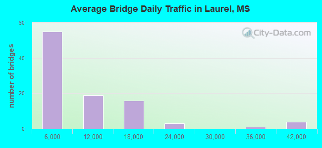
- 766,825Total average daily traffic
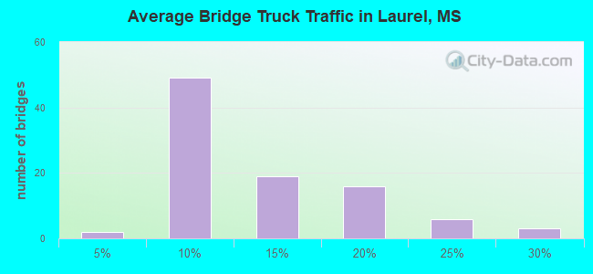
- 106,408Total average daily truck traffic
- National Bridge Inventory (NBI) Registered Bridges for Laurel
- No street view available for this location
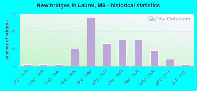
- New bridges - historical statistics
- 11920-1929
- 11930-1939
- 11940-1949
- 101950-1959
- 281960-1969
- 131970-1979
- 151980-1989
- 151990-1999
- 92000-2009
- 42010-2019
- 12020-2022
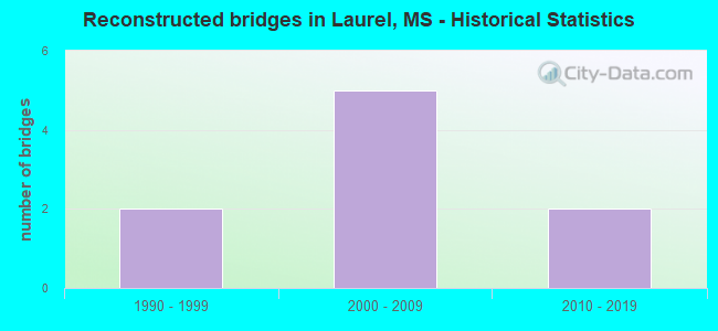
- Reconstructed bridges - Historical Statistics
- 21990-1999
- 52000-2009
- 22010-2019
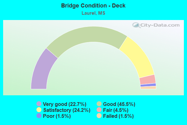
- Bridge Condition - Deck
- 22.7%Very good
- 45.5%Good
- 24.2%Satisfactory
- 4.5%Fair
- 1.5%Poor
- 1.5%Failed
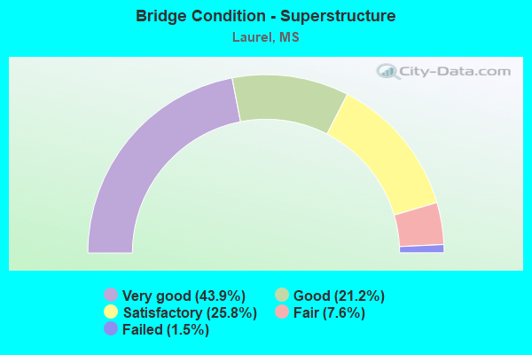
- Bridge Condition - Superstructure
- 43.9%Very good
- 21.2%Good
- 25.8%Satisfactory
- 7.6%Fair
- 1.5%Failed
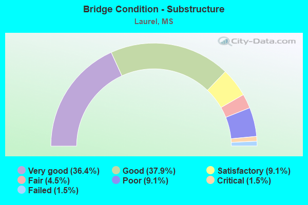
- Bridge Condition - Substructure
- 36.4%Very good
- 37.9%Good
- 9.1%Satisfactory
- 4.5%Fair
- 9.1%Poor
- 1.5%Critical
- 1.5%Failed

- Bridge Condition - Channel
- 1.5%Excellent
- 9.2%Very good
- 36.9%Good
- 32.3%Satisfactory
- 18.5%Fair
- 1.5%Poor
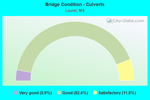
- Bridge Condition - Culverts
- 5.9%Very good
- 82.4%Good
- 11.8%Satisfactory
Find on map >> Show street view
Structure Number: SA3400000000238, Location: SEC 3 T 8N R12W (Lat: 31.694750, Lng: -89.184944), Route carried "on" structure: County highway 222, Year Built: 2012, Status: Open, Structure Length: 4.88m (16.01ft), Average Daily Traffic: 320 (year 2020), Truck Traffic: 8%, Average Future Daily Traffic: 48 (year 2040), Design Load: HL 93, Features Intersected: HORSE CREEK, Facility Carried by Structure: FLYNT ROAD
Minimum Vertical Clearance: 30+ m (98+ ft), Kilometerpoint: 0.160, Lanes on structure: 2, Owner: County Highway Agency, Approaching Roadway Width: 7.3m (24.0ft), Material/Design: Concrete, Design/Construction: Channel Beam, Number Of Spans In Main Unit: 4, Length of Maximum Span: 12.2m (40.0ft), Curb or Sidewalk Widths: Left: 0.5m (1.6ft), Right: 0.5m (1.6ft), Curb-To-Curb Width: 8.5m (27.9ft), Out-to-Out Width: 9.5m (31.2ft)
Condition: Deck: Very good, Superstructure: Very good, Substructure: Very good, Channel: Very good, Operating Rating: 50.5 metric tons, Method Used To Determine Operating Rating: Load and Resistance Factor Rating (LRFR) rating reported by rating factor(RF) method using HL-93 loadings, Inventory Rating: 38.9 metric tons, Method Used To Determine Inventory Rating: Load and Resistance Factor Rating (LRFR) rating reported by rating factor(RF) method using HL-93 loadings, Structural Evaluation: Equal to present desirable criteria, Deck Geometry: Equal to present minimum criteria, Waterway Adequacy: Equal to present desirable criteria, Approach Roadway Alignment: Equal to present desirable criteria, Designated Inspection Frequency: Every 24 months, Inspection Date: April 2021, Deck Structure Type: Concrete Precast Panels, Wearing Surface/Protective System: Wearing Surface: Monolithic Concrete
Find on map >> Show street view
Structure Number: SA340000000A125, Location: SEC 28 T 8N R11W B (Lat: 31.625314, Lng: -89.098831), Route carried "on" structure: County highway 249, Year Built: 2018, Status: Open, Structure Length: 2.84m (9.32ft), Average Daily Traffic: 1,800 (year 2020), Truck Traffic: 8%, Average Future Daily Traffic: 2,700 (year 2040), Design Load: H 15, Features Intersected: FLAT BRANCH, Facility Carried by Structure: E'VILLE-TKRS CR RD
Minimum Vertical Clearance: 30+ m (98+ ft), Kilometerpoint: 8.690, Lanes on structure: 2, Owner: County Highway Agency, Approaching Roadway Width: 7.0m (23.0ft), Material/Design: Concrete, Design/Construction: Channel Beam, Number Of Spans In Main Unit: 3, Length of Maximum Span: 9.5m (31.2ft), Curb or Sidewalk Widths: Left: 0.2m (0.7ft), Right: 0.2m (0.7ft), Curb-To-Curb Width: 8.1m (26.6ft), Out-to-Out Width: 8.5m (27.9ft)
Condition: Deck: Very good, Superstructure: Good, Substructure: Very good, Channel: Very good, Operating Rating: 35.8 metric tons, Method Used To Determine Operating Rating: Load Factor (LF), Inventory Rating: 21.5 metric tons, Method Used To Determine Inventory Rating: Load Factor (LF), Structural Evaluation: Somewhat better than minimum adequacy, Deck Geometry: Meets minimum limits, Waterway Adequacy: Better than present minimum criteria, Approach Roadway Alignment: Equal to present desirable criteria, Designated Inspection Frequency: Every 24 months, Inspection Date: December 2020, Deck Structure Type: Concrete Precast Panels, Wearing Surface/Protective System: Wearing Surface: Monolithic Concrete
Find on map >> Show street view
Structure Number: 11000590340920A, Location: I 59 OVER US 11 (Lat: 31.664239, Lng: -89.159431), Route carried "under" structure: US 11, Year Built: 1960, Structure Length: 0. m, Average Daily Traffic: 7,800 (year 2017), Truck Traffic: 8%, Features Intersected: US 11, Facility Carried by Structure: I 59
Minimum Vertical Clearance: 4.83m (15.85ft), Kilometerpoint: 29.628, Lanes on structure: 2, Lanes under structure: 2, Material/Design: Concrete continuous, Design/Construction: Box Beam or Girders - Single/Spread, Length of Maximum Span: 24.4m (80.1ft)
Find on map >> Show street view
Structure Number: 11000590340920B, Location: I 59 OVER US 11 (Lat: 31.664369, Lng: -89.159111), Route carried "under" structure: US 11, Year Built: 1960, Structure Length: 0. m, Average Daily Traffic: 5,600 (year 2017), Truck Traffic: 8%, Features Intersected: US 11, Facility Carried by Structure: I 59
Minimum Vertical Clearance: 4.85m (15.91ft), Kilometerpoint: 29.662, Lanes on structure: 2, Lanes under structure: 2, Material/Design: Concrete continuous, Design/Construction: Box Beam or Girders - Single/Spread, Length of Maximum Span: 24.4m (80.1ft)
Find on map >> Show street view
Structure Number: 11000590340940A, Location: 0.5 MI N JCT US 84/SR 15 (Lat: 31.684900, Lng: -89.134811), Route carried "under" structure: US 11, Year Built: 2009, Structure Length: 0. m, Average Daily Traffic: 5,600 (year 2017), Truck Traffic: 8%, Features Intersected: US 11/AL GREAT SOUTH RR, Facility Carried by Structure: I 59
Minimum Vertical Clearance: 9.12m (29.92ft), Kilometerpoint: 32.984, Lanes on structure: 2, Lanes under structure: 10, Material/Design: Prestressed concrete, Design/Construction: Stringer/Multi-beam, Length of Maximum Span: 42.7m (140.1ft)
Find on map >> Show street view
Structure Number: 11000590340940B, Location: 0.5 MI N JCT US 84/SR 15 (Lat: 31.684789, Lng: -89.134889), Route carried "under" structure: US 11, Year Built: 2009, Structure Length: 0. m, Average Daily Traffic: 6,100 (year 2017), Truck Traffic: 8%, Features Intersected: US 11/AL GREAT SOUTH RR, Facility Carried by Structure: I 59
Minimum Vertical Clearance: 8.40m (27.56ft), Kilometerpoint: 32.815, Lanes on structure: 2, Lanes under structure: 10, Material/Design: Prestressed concrete, Design/Construction: Stringer/Multi-beam, Length of Maximum Span: 42.7m (140.1ft)
Find on map >> Show street view
Structure Number: 11000590340952, Location: I 59 OVER SR 15 SOUTH (Lat: 31.687500, Lng: -89.123150), Route carried "under" structure: State highway 15, Year Built: 1959, Structure Length: 0. m, Average Daily Traffic: 8,300 (year 2017), Truck Traffic: 8%, Features Intersected: SR 15, Facility Carried by Structure: I 59
Minimum Vertical Clearance: 4.47m (14.67ft), Kilometerpoint: 33.674, Lanes on structure: 2, Lanes under structure: 2, Material/Design: Steel, Design/Construction: Stringer/Multi-beam, Length of Maximum Span: 16.8m (55.1ft)
Find on map >> Show street view
Structure Number: 11000590340961, Location: I 59 OVER US 84 EAST (Lat: 31.697711, Lng: -89.117289), Route carried "under" structure: US 84, Year Built: 1959, Structure Length: 0. m, Average Daily Traffic: 8,000 (year 2017), Truck Traffic: 8%, Features Intersected: US 84, Facility Carried by Structure: I 59
Minimum Vertical Clearance: 4.99m (16.37ft), Kilometerpoint: 26.141, Lanes on structure: 6, Lanes under structure: 3, Material/Design: Steel, Design/Construction: Stringer/Multi-beam, Length of Maximum Span: 16.8m (55.1ft)
Find on map >> Show street view
Structure Number: 21000110341047, Location: IN LAUREL (Lat: 31.695481, Lng: -89.125881), Route carried "under" structure: US 11, Year Built: 1935, Structure Length: 0. m, Average Daily Traffic: 7,900 (year 2017), Truck Traffic: 8%, Features Intersected: US 11, Facility Carried by Structure: NORFOLK S RR
Minimum Vertical Clearance: 4.15m (13.62ft), Kilometerpoint: 34.454, Lanes under structure: 2, Material/Design: Steel, Design/Construction: Stringer/Multi-beam, Length of Maximum Span: 11.6m (38.1ft)
Find on map >> Show street view
Structure Number: 21000110341076, Location: US 11 OVER I 59 (Lat: 31.721700, Lng: -89.104000), Route carried "under" structure: Interstate 59, Year Built: 1964, Structure Length: 0. m, Average Daily Traffic: 10,000 (year 2018), Truck Traffic: 21%, Features Intersected: I 59, Facility Carried by Structure: US 11
Minimum Vertical Clearance: 5.01m (16.44ft), Kilometerpoint: 12.360, Lanes on structure: 2, Lanes under structure: 4, Material/Design: Concrete continuous, Design/Construction: Box Beam or Girders - Single/Spread, Length of Maximum Span: 25.9m (85.0ft)
Find on map >> Show street view
Structure Number: 21000110341076, Location: US 11 OVER I 59 (Lat: 31.721750, Lng: -89.103769), Route carried "under" structure: Interstate 59, Year Built: 1964, Structure Length: 0. m, Average Daily Traffic: 10,000 (year 2018), Truck Traffic: 21%, Features Intersected: I 59, Facility Carried by Structure: US 11
Minimum Vertical Clearance: 5.47m (17.95ft), Kilometerpoint: 40.940, Lanes on structure: 2, Lanes under structure: 4, Material/Design: Concrete continuous, Design/Construction: Box Beam or Girders - Single/Spread, Length of Maximum Span: 25.9m (85.0ft)
Find on map >> Show street view
Structure Number: 31000150340826, Location: US84/SR15 OVER I 59 (Lat: 31.684311, Lng: -89.146689), Route carried "under" structure: Interstate 59, Year Built: 1960, Structure Length: 0. m, Average Daily Traffic: 17,000 (year 2018), Truck Traffic: 20%, Features Intersected: I 59, Facility Carried by Structure: US84/SR15
Minimum Vertical Clearance: 4.97m (16.31ft), Kilometerpoint: 19.095, Lanes on structure: 6, Lanes under structure: 6, Material/Design: Steel, Design/Construction: Stringer/Multi-beam, Length of Maximum Span: 15.9m (52.2ft)
Find on map >> Show street view
Structure Number: 31000150340826, Location: US84/SR15 OVER I 59 (Lat: 31.684189, Lng: -89.146689), Route carried "under" structure: Interstate 59, Year Built: 1960, Structure Length: 0. m, Average Daily Traffic: 17,000 (year 2018), Truck Traffic: 20%, Features Intersected: I 59, Facility Carried by Structure: US84/SR15
Minimum Vertical Clearance: 4.83m (15.85ft), Kilometerpoint: 34.179, Lanes on structure: 6, Lanes under structure: 6, Material/Design: Steel, Design/Construction: Stringer/Multi-beam, Length of Maximum Span: 15.9m (52.2ft)
Find on map >> Show street view
Structure Number: 51000590340925, Location: 1.2 MI S JCT US 84/SR 15 (Lat: 31.670839, Lng: -89.157819), Route carried "under" structure: Interstate 59, Year Built: 1960, Structure Length: 0. m, Average Daily Traffic: 15,500 (year 2017), Truck Traffic: 10%, Features Intersected: I 59, Facility Carried by Structure: AIRPORT ROAD
Minimum Vertical Clearance: 5.31m (17.42ft), Kilometerpoint: 21.110, Lanes on structure: 2, Lanes under structure: 4, Material/Design: Steel, Design/Construction: Stringer/Multi-beam, Length of Maximum Span: 18.3m (60.0ft)
Find on map >> Show street view
Structure Number: 51000590340925, Location: 1.2 MI S JCT US 84/SR 15 (Lat: 31.670839, Lng: -89.157619), Route carried "under" structure: Interstate 59, Year Built: 1960, Structure Length: 0. m, Average Daily Traffic: 15,500 (year 2017), Truck Traffic: 10%, Features Intersected: I 59, Facility Carried by Structure: AIRPORT ROAD
Minimum Vertical Clearance: 5.25m (17.22ft), Kilometerpoint: 32.185, Lanes on structure: 2, Lanes under structure: 4, Material/Design: Steel, Design/Construction: Stringer/Multi-beam, Length of Maximum Span: 18.3m (60.0ft)
Find on map >> Show street view
Structure Number: 51000590340939, Location: 0.2 MI E JCT US 84/SR 15 (Lat: 31.684211, Lng: -89.142700), Route carried "under" structure: Interstate 59, Year Built: 1960, Structure Length: 0. m, Average Daily Traffic: 16,500 (year 2017), Truck Traffic: 10%, Features Intersected: I 59, Facility Carried by Structure: 13TH AVE
Minimum Vertical Clearance: 4.86m (15.94ft), Kilometerpoint: 18.717, Lanes on structure: 3, Lanes under structure: 6, Material/Design: Steel, Design/Construction: Stringer/Multi-beam, Length of Maximum Span: 15.9m (52.2ft)
Find on map >> Show street view
Structure Number: 51000590340939, Location: 0.2 MI E JCT US 84/SR 15 (Lat: 31.684081, Lng: -89.142700), Route carried "under" structure: Interstate 59, Year Built: 1960, Structure Length: 0. m, Average Daily Traffic: 16,500 (year 2017), Truck Traffic: 10%, Features Intersected: I 59, Facility Carried by Structure: 13TH AVE
Minimum Vertical Clearance: 4.84m (15.88ft), Kilometerpoint: 34.559, Lanes on structure: 3, Lanes under structure: 6, Material/Design: Steel, Design/Construction: Stringer/Multi-beam, Length of Maximum Span: 15.9m (52.2ft)