Bridge Statistics for Lancaster, California (CA)
Condition, Traffic, Stress, Structural Evaluation, Project Costs
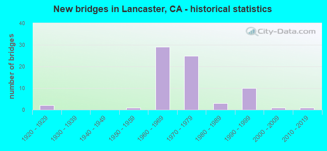
- New bridges - historical statistics
- 21920-1929
- 11950-1959
- 291960-1969
- 251970-1979
- 31980-1989
- 101990-1999
- 12000-2009
- 12010-2019
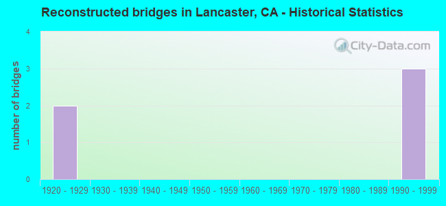
- Reconstructed bridges - Historical Statistics
- 21920-1929
- 01930-1939
- 01940-1949
- 01950-1959
- 01960-1969
- 01970-1979
- 01980-1989
- 31990-1999
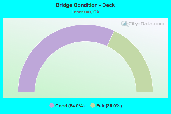
- Bridge Condition - Deck
- 64.0%Good
- 36.0%Fair
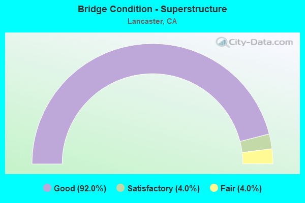
- Bridge Condition - Superstructure
- 92.0%Good
- 4.0%Satisfactory
- 4.0%Fair
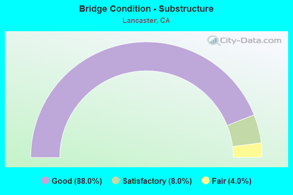
- Bridge Condition - Substructure
- 88.0%Good
- 8.0%Satisfactory
- 4.0%Fair
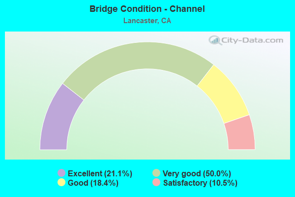
- Bridge Condition - Channel
- 21.1%Excellent
- 50.0%Very good
- 18.4%Good
- 10.5%Satisfactory
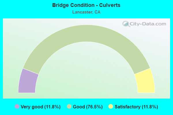
- Bridge Condition - Culverts
- 11.8%Very good
- 76.5%Good
- 11.8%Satisfactory
Find on map >> Show street view
Structure Number: 53C0416, Location: 200FT E/O SR-14 FWY (Lat: 34.703917, Lng: -118.168497), Route carried "on" structure: City street Q006, Year Built: 1968, Status: Open, Structure Length: 5.46m (17.91ft), Average Daily Traffic: 25,064 (year 2012), Truck Traffic: 7%, Average Future Daily Traffic: 30,077 (year 2040), Features Intersected: AMARGOSA DRN, Facility Carried by Structure: AVE I
Minimum Vertical Clearance: 30.47m (99.97ft), Kilometerpoint: 0.000, Lanes on structure: 6, Owner: City or Municipal Highway Agency, Approaching Roadway Width: 25.6m (84.0ft), Material/Design: Concrete, Design/Construction: Culvert, Number Of Spans In Main Unit: 14, Length of Maximum Span: 3.7m (12.1ft), Curb or Sidewalk Widths: Left: 2.4m (7.9ft), Right: 2.0m (6.6ft), Curb-To-Curb Width: 24.2m (79.4ft), Out-to-Out Width: 29.9m (98.1ft)
Condition: Channel: Good, Culverts: Good, Operating Rating: 54.1 metric tons, Method Used To Determine Operating Rating: Field evaluation and documented engineering judgment, Inventory Rating: 32.4 metric tons, Method Used To Determine Inventory Rating: Field evaluation and documented engineering judgment, Structural Evaluation: Better than present minimum criteria, Deck Geometry: Somewhat better than minimum adequacy, Waterway Adequacy: Equal to present minimum criteria, Approach Roadway Alignment: Equal to present desirable criteria, Designated Inspection Frequency: Every 48 months, Inspection Date: May 2020
Find on map >> Show street view
Structure Number: 53C0871, Location: 200FT E/O SR-14 FWY (Lat: 34.684378, Lng: -118.165511), Route carried "on" structure: City street Q043, Year Built: 1972, Status: Open, Structure Length: 3.08m (10.10ft), Average Daily Traffic: 26,800 (year 2013), Truck Traffic: 4%, Average Future Daily Traffic: 40,810 (year 2040), Features Intersected: AMARGOSA DRN, Facility Carried by Structure: 20TH ST W
Minimum Vertical Clearance: 30.47m (99.97ft), Kilometerpoint: 0.000, Lanes on structure: 6, Owner: City or Municipal Highway Agency, Approaching Roadway Width: 16.5m (54.1ft), Skew: 22 degrees, Material/Design: Concrete, Design/Construction: Culvert, Number Of Spans In Main Unit: 7, Length of Maximum Span: 3.7m (12.1ft), Curb or Sidewalk Widths: Left: 2.6m (8.5ft), Right: 2.5m (8.2ft), Curb-To-Curb Width: 25.5m (83.7ft), Out-to-Out Width: 35.4m (116.1ft)
Condition: Channel: Good, Culverts: Satisfactory, Operating Rating: 54.1 metric tons, Method Used To Determine Operating Rating: Field evaluation and documented engineering judgment, Inventory Rating: 32.4 metric tons, Method Used To Determine Inventory Rating: Field evaluation and documented engineering judgment, Structural Evaluation: Equal to present minimum criteria, Deck Geometry: Somewhat better than minimum adequacy, Waterway Adequacy: Equal to present minimum criteria, Approach Roadway Alignment: Equal to present desirable criteria, Designated Inspection Frequency: Every 48 months, Inspection Date: May 2020
Find on map >> Show street view
Structure Number: 53C0872, Location: 300FT E/O SR-14 FWY (Lat: 34.689289, Lng: -118.168572), Route carried "on" structure: City street Q036, Year Built: 1972, Status: Open, Structure Length: 3.07m (10.07ft), Average Daily Traffic: 33,592 (year 2012), Truck Traffic: 4%, Average Future Daily Traffic: 40,310 (year 2040), Features Intersected: AMARGOSA CRK, Facility Carried by Structure: AVE J
Minimum Vertical Clearance: 30.47m (99.97ft), Kilometerpoint: 0.000, Lanes on structure: 6, Owner: City or Municipal Highway Agency, Approaching Roadway Width: 25.7m (84.3ft), Skew: 1 degrees, Material/Design: Concrete, Design/Construction: Culvert, Number Of Spans In Main Unit: 8, Length of Maximum Span: 3.7m (12.1ft), Curb or Sidewalk Widths: Left: 2.3m (7.5ft), Right: 2.2m (7.2ft), Curb-To-Curb Width: 21.4m (70.2ft), Out-to-Out Width: 30.7m (100.7ft)
Condition: Channel: Good, Culverts: Good, Operating Rating: 54.1 metric tons, Method Used To Determine Operating Rating: Field evaluation and documented engineering judgment, Inventory Rating: 32.4 metric tons, Method Used To Determine Inventory Rating: Field evaluation and documented engineering judgment, Structural Evaluation: Better than present minimum criteria, Deck Geometry: High priority of replacement, Waterway Adequacy: Equal to present desirable criteria, Approach Roadway Alignment: Equal to present desirable criteria, Designated Inspection Frequency: Every 48 months, Inspection Date: May 2020
Find on map >> Show street view
Structure Number: 53C0874, Location: 200FT E/O SR-14 FWY (Lat: 34.696625, Lng: -118.169394), Route carried "on" structure: City street Q038, Year Built: 1972, Status: Open, Structure Length: 3.11m (10.20ft), Average Daily Traffic: 15,300 (year 2016), Truck Traffic: 2%, Average Future Daily Traffic: 18,000 (year 2040), Features Intersected: AMARGOSA DRN, Facility Carried by Structure: LANCASTER BLVD
Minimum Vertical Clearance: 30.47m (99.97ft), Kilometerpoint: 0.000, Lanes on structure: 4, Owner: City or Municipal Highway Agency, Approaching Roadway Width: 19.2m (63.0ft), Material/Design: Concrete, Design/Construction: Culvert, Number Of Spans In Main Unit: 8, Length of Maximum Span: 3.7m (12.1ft), Curb or Sidewalk Widths: Left: 1.9m (6.2ft), Right: 1.7m (5.6ft), Curb-To-Curb Width: 19.2m (63.0ft), Out-to-Out Width: 24.3m (79.7ft)
Condition: Channel: Good, Culverts: Good, Operating Rating: 54.1 metric tons, Method Used To Determine Operating Rating: Field evaluation and documented engineering judgment, Inventory Rating: 32.4 metric tons, Method Used To Determine Inventory Rating: Field evaluation and documented engineering judgment, Structural Evaluation: Better than present minimum criteria, Deck Geometry: Equal to present minimum criteria, Waterway Adequacy: Equal to present desirable criteria, Approach Roadway Alignment: Equal to present desirable criteria, Designated Inspection Frequency: Every 48 months, Inspection Date: April 2020
Find on map >> Show street view
Structure Number: 53C1049, Location: 200FT E/O SIERRA HWY (Lat: 34.645725, Lng: -118.127403), Route carried "on" structure: City street Q031, Year Built: 1950, Status: Open, Structure Length: 0.73m (2.40ft), Average Daily Traffic: 18,616 (year 2012), Truck Traffic: 4%, Average Future Daily Traffic: 22,339 (year 2040), Features Intersected: UNNAMED WASH, Facility Carried by Structure: COLUMBIA WAY
Minimum Vertical Clearance: 30.47m (99.97ft), Kilometerpoint: 0.000, Lanes on structure: 5, Owner: City or Municipal Highway Agency, Approaching Roadway Width: 25.5m (83.7ft), Skew: 20 degrees, Material/Design: Steel, Design/Construction: Culvert, Number Of Spans In Main Unit: 4, Length of Maximum Span: 3.7m (12.1ft), Curb or Sidewalk Widths: Left: 2.2m (7.2ft), Right: 2.2m (7.2ft), Curb-To-Curb Width: 20.4m (66.9ft), Out-to-Out Width: 30.5m (100.1ft)
Condition: Channel: Satisfactory, Culverts: Satisfactory, Operating Rating: 54.1 metric tons, Method Used To Determine Operating Rating: Field evaluation and documented engineering judgment, Inventory Rating: 32.4 metric tons, Method Used To Determine Inventory Rating: Field evaluation and documented engineering judgment, Structural Evaluation: Equal to present minimum criteria, Deck Geometry: Somewhat better than minimum adequacy, Waterway Adequacy: Equal to present minimum criteria, Approach Roadway Alignment: Equal to present desirable criteria, Designated Inspection Frequency: Every 48 months, Inspection Date: May 2020
Find on map >> Show street view
Structure Number: 53C1844, Location: 3.0MI W/O 50TH ST E (Lat: 34.675269, Lng: -118.022125), Route carried "on" structure: City street Q034, Year Built: 1985, Status: Open, Structure Length: 1.66m (5.45ft), Average Daily Traffic: 2,727 (year 2012), Truck Traffic: 2%, Average Future Daily Traffic: 3,000 (year 2040), Design Load: HS 20, Features Intersected: LITTLE ROCK CRK, Facility Carried by Structure: AVE K
Minimum Vertical Clearance: 30.47m (99.97ft), Kilometerpoint: 0.000, Lanes on structure: 2, Owner: City or Municipal Highway Agency, Approaching Roadway Width: 6.7m (22.0ft), Material/Design: Concrete continuous, Design/Construction: Slab, Number Of Spans In Main Unit: 2, Length of Maximum Span: 7.3m (24.0ft), Curb-To-Curb Width: 6.7m (22.0ft), Out-to-Out Width: 12.4m (40.7ft)
Condition: Deck: Good, Superstructure: Satisfactory, Substructure: Satisfactory, Channel: Satisfactory, Operating Rating: 64.5 metric tons, Method Used To Determine Operating Rating: Load Factor (LF), Inventory Rating: 38.6 metric tons, Method Used To Determine Inventory Rating: Load Factor (LF), Structural Evaluation: Equal to present minimum criteria, Deck Geometry: High priority of replacement, Waterway Adequacy: Equal to present minimum criteria, Approach Roadway Alignment: Equal to present desirable criteria, Designated Inspection Frequency: Every 48 months, Inspection Date: May 2020, Deck Structure Type: Concrete Cast-file-Place, Wearing Surface/Protective System: Wearing Surface: Bituminous
Find on map >> Show street view
Structure Number: 53C1868, Location: 0.6MI W/O SIERRA HWY (Lat: 34.645689, Lng: -118.138825), Route carried "on" structure: City street Q031, Year Built: 1989, Status: Open, Structure Length: 0.98m (3.22ft), Average Daily Traffic: 8,670 (year 2012), Truck Traffic: 2%, Average Future Daily Traffic: 9,971 (year 2040), Features Intersected: AMARGOSA CRK, Facility Carried by Structure: COLUMBIA WAY
Minimum Vertical Clearance: 30.47m (99.97ft), Kilometerpoint: 0.000, Lanes on structure: 5, Owner: City or Municipal Highway Agency, Approaching Roadway Width: 20.4m (66.9ft), Skew: 20 degrees, Material/Design: Concrete, Design/Construction: Culvert, Number Of Spans In Main Unit: 2, Length of Maximum Span: 4.9m (16.1ft), Curb or Sidewalk Widths: Left: 2.2m (7.2ft), Right: 2.2m (7.2ft), Curb-To-Curb Width: 25.6m (84.0ft), Out-to-Out Width: 31.2m (102.4ft)
Condition: Channel: Excellent, Culverts: Good, Operating Rating: 54.1 metric tons, Method Used To Determine Operating Rating: Field evaluation and documented engineering judgment, Inventory Rating: 32.4 metric tons, Method Used To Determine Inventory Rating: Field evaluation and documented engineering judgment, Structural Evaluation: Better than present minimum criteria, Deck Geometry: Superior to present desirable criteria, Waterway Adequacy: Equal to present desirable criteria, Approach Roadway Alignment: Equal to present desirable criteria, Designated Inspection Frequency: Every 48 months, Inspection Date: May 2020
Find on map >> Show street view
Structure Number: 53C1947, Location: 0.1MI S/O AVE K (Lat: 34.669653, Lng: -118.147675), Route carried "on" structure: City street Q002, Year Built: 1990, Status: Open, Structure Length: 1.38m (4.53ft), Average Daily Traffic: 32,136 (year 2012), Truck Traffic: 2%, Average Future Daily Traffic: 38,563 (year 2040), Features Intersected: AMARGOSA DRN, Facility Carried by Structure: 10TH ST W
Minimum Vertical Clearance: 30.47m (99.97ft), Kilometerpoint: 0.000, Lanes on structure: 6, Owner: City or Municipal Highway Agency, Approaching Roadway Width: 25.6m (84.0ft), Skew: 4 degrees, Material/Design: Concrete, Design/Construction: Culvert, Number Of Spans In Main Unit: 2, Length of Maximum Span: 3.3m (10.8ft), Curb or Sidewalk Widths: Left: 2.3m (7.5ft), Right: 2.2m (7.2ft), Curb-To-Curb Width: 25.6m (84.0ft), Out-to-Out Width: 30.5m (100.1ft)
Condition: Channel: Excellent, Culverts: Good, Operating Rating: 54.1 metric tons, Method Used To Determine Operating Rating: Field evaluation and documented engineering judgment, Inventory Rating: 32.4 metric tons, Method Used To Determine Inventory Rating: Field evaluation and documented engineering judgment, Structural Evaluation: Better than present minimum criteria, Deck Geometry: Somewhat better than minimum adequacy, Waterway Adequacy: Superior to present desirable criteria, Approach Roadway Alignment: Equal to present desirable criteria, Designated Inspection Frequency: Every 48 months, Inspection Date: May 2020
Find on map >> Show street view
Structure Number: 53C1948, Location: 0.3MI W/O 20TH ST W (Lat: 34.682081, Lng: -118.171350), Route carried "on" structure: City street Q035, Year Built: 1990, Status: Open, Structure Length: 0.76m (2.49ft), Average Daily Traffic: 13,464 (year 2012), Truck Traffic: 2%, Average Future Daily Traffic: 15,484 (year 2040), Features Intersected: AMARGOSA DRN, Facility Carried by Structure: AVE J-8
Minimum Vertical Clearance: 30.47m (99.97ft), Kilometerpoint: 0.000, Lanes on structure: 4, Owner: City or Municipal Highway Agency, Approaching Roadway Width: 19.5m (64.0ft), Material/Design: Concrete, Design/Construction: Culvert, Number Of Spans In Main Unit: 2, Length of Maximum Span: 3.7m (12.1ft), Curb or Sidewalk Widths: Left: 2.3m (7.5ft), Right: 2.1m (6.9ft), Curb-To-Curb Width: 19.5m (64.0ft), Out-to-Out Width: 24.6m (80.7ft)
Condition: Channel: Excellent, Culverts: Very good, Operating Rating: 54.1 metric tons, Method Used To Determine Operating Rating: Field evaluation and documented engineering judgment, Inventory Rating: 32.4 metric tons, Method Used To Determine Inventory Rating: Field evaluation and documented engineering judgment, Structural Evaluation: Equal to present desirable criteria, Deck Geometry: Better than present minimum criteria, Waterway Adequacy: Superior to present desirable criteria, Approach Roadway Alignment: Equal to present desirable criteria, Designated Inspection Frequency: Every 48 months, Inspection Date: May 2020
Find on map >> Show street view
Structure Number: 53C1949, Location: 0.1MI E/O 25TH ST W (Lat: 34.685731, Lng: -118.172092), Route carried "on" structure: City street , Year Built: 1991, Status: Open, Structure Length: 1.04m (3.41ft), Average Daily Traffic: 510 (year 2012), Truck Traffic: 1%, Average Future Daily Traffic: 561 (year 2040), Features Intersected: AMARGOSA DRN, Facility Carried by Structure: AVE J-4
Minimum Vertical Clearance: 30.47m (99.97ft), Kilometerpoint: 0.000, Lanes on structure: 2, Owner: City or Municipal Highway Agency, Approaching Roadway Width: 12.1m (39.7ft), Skew: 4 degrees, Material/Design: Concrete, Design/Construction: Culvert, Number Of Spans In Main Unit: 2, Length of Maximum Span: 3.7m (12.1ft), Curb or Sidewalk Widths: Left: 1.6m (5.2ft), Right: 1.6m (5.2ft), Curb-To-Curb Width: 12.1m (39.7ft), Out-to-Out Width: 15.8m (51.8ft)
Condition: Channel: Excellent, Culverts: Satisfactory, Operating Rating: 54.1 metric tons, Method Used To Determine Operating Rating: Field evaluation and documented engineering judgment, Inventory Rating: 32.4 metric tons, Method Used To Determine Inventory Rating: Field evaluation and documented engineering judgment, Structural Evaluation: Equal to present minimum criteria, Deck Geometry: Better than present minimum criteria, Waterway Adequacy: Superior to present desirable criteria, Approach Roadway Alignment: Equal to present desirable criteria, Designated Inspection Frequency: Every 48 months, Inspection Date: May 2020
Find on map >> Show street view
Structure Number: 53C1951, Location: 0.2MI E/O 30TH ST (Lat: 34.696564, Lng: -118.179453), Route carried "on" structure: City street Q038, Year Built: 1991, Status: Open, Structure Length: 1.52m (4.99ft), Average Daily Traffic: 9,690 (year 2012), Truck Traffic: 2%, Average Future Daily Traffic: 11,144 (year 2040), Features Intersected: AMARGOSA DRN, Facility Carried by Structure: LANCASTER BLVD
Minimum Vertical Clearance: 30.47m (99.97ft), Kilometerpoint: 0.000, Lanes on structure: 5, Owner: City or Municipal Highway Agency, Approaching Roadway Width: 21.3m (69.9ft), Skew: 20 degrees, Material/Design: Concrete, Design/Construction: Culvert, Number Of Spans In Main Unit: 4, Length of Maximum Span: 3.7m (12.1ft), Curb or Sidewalk Widths: Left: 2.4m (7.9ft), Right: 2.4m (7.9ft), Curb-To-Curb Width: 24.3m (79.7ft), Out-to-Out Width: 36.2m (118.8ft)
Condition: Channel: Excellent, Culverts: Very good, Operating Rating: 54.1 metric tons, Method Used To Determine Operating Rating: Field evaluation and documented engineering judgment, Inventory Rating: 32.4 metric tons, Method Used To Determine Inventory Rating: Field evaluation and documented engineering judgment, Structural Evaluation: Equal to present desirable criteria, Deck Geometry: Superior to present desirable criteria, Waterway Adequacy: Superior to present desirable criteria, Approach Roadway Alignment: Equal to present desirable criteria, Designated Inspection Frequency: Every 48 months, Inspection Date: May 2020
Find on map >> Show street view
Structure Number: 53C1952, Location: 0.1MI E/O 30TH ST W (Lat: 34.703808, Lng: -118.183569), Route carried "on" structure: City street Q006, Year Built: 1991, Status: Open, Structure Length: 1.68m (5.51ft), Average Daily Traffic: 9,486 (year 2012), Truck Traffic: 2%, Average Future Daily Traffic: 10,909 (year 2040), Features Intersected: AMARGOSA DRN, Facility Carried by Structure: W AVE I
Minimum Vertical Clearance: 30.47m (99.97ft), Kilometerpoint: 0.000, Lanes on structure: 8, Owner: City or Municipal Highway Agency, Approaching Roadway Width: 27.3m (89.6ft), Skew: 20 degrees, Material/Design: Concrete, Design/Construction: Culvert, Number Of Spans In Main Unit: 4, Length of Maximum Span: 4.0m (13.1ft), Curb or Sidewalk Widths: Left: 4.9m (16.1ft), Right: 2.4m (7.9ft), Curb-To-Curb Width: 37.2m (122.0ft), Out-to-Out Width: 58.8m (192.9ft)
Condition: Channel: Excellent, Culverts: Very good, Operating Rating: 54.1 metric tons, Method Used To Determine Operating Rating: Field evaluation and documented engineering judgment, Inventory Rating: 32.4 metric tons, Method Used To Determine Inventory Rating: Field evaluation and documented engineering judgment, Structural Evaluation: Equal to present desirable criteria, Deck Geometry: Superior to present desirable criteria, Waterway Adequacy: Superior to present desirable criteria, Approach Roadway Alignment: Equal to present desirable criteria, Designated Inspection Frequency: Every 48 months, Inspection Date: May 2020
Find on map >> Show street view
Structure Number: 53C1987, Location: 1.3MI E/O SR-14 FWY (Lat: 34.660381, Lng: -118.130903), Route carried "on" structure: City street Q032, Year Built: 1993, Status: Open, Structure Length: 8.50m (27.89ft), Average Daily Traffic: 27,560 (year 2012), Truck Traffic: 2%, Average Future Daily Traffic: 33,072 (year 2040), Design Load: HS 20, Features Intersected: SIERRA HWY / METROLINK, Facility Carried by Structure: AVE L
Minimum Vertical Clearance: 30.47m (99.97ft), Kilometerpoint: 0.000, Lanes on structure: 4, Lanes under structure: 7, Owner: City or Municipal Highway Agency, Approaching Roadway Width: 31.7m (104.0ft), Skew: 20 degrees, Material/Design: Prestressed concrete continuous, Design/Construction: Box Beam or Girders - Multiple, Number Of Spans In Main Unit: 3, Length of Maximum Span: 29.6m (97.1ft), Curb or Sidewalk Widths: Left: 1.8m (5.9ft), Right: 1.8m (5.9ft), Curb-To-Curb Width: 30.3m (99.4ft), Out-to-Out Width: 36.0m (118.1ft)
Condition: Deck: Good, Superstructure: Good, Substructure: Good, Operating Rating: 76.5 metric tons, Method Used To Determine Operating Rating: Load Factor (LF), Inventory Rating: 45.7 metric tons, Method Used To Determine Inventory Rating: Load Factor (LF), Structural Evaluation: Better than present minimum criteria, Deck Geometry: Superior to present desirable criteria, Underclear: Meets minimum limits, Approach Roadway Alignment: Equal to present desirable criteria, Designated Inspection Frequency: Every 48 months, Inspection Date: May 2020, Deck Structure Type: Concrete Cast-file-Place, Wearing Surface/Protective System: Wearing Surface: Monolithic Concrete
Find on map >> Show street view
Structure Number: 53C2093, Location: 0.3MI N/O AVE K (Lat: 34.679339, Lng: -118.156675), Route carried "on" structure: City street Q044, Year Built: 2002, Status: Open, Structure Length: 2.37m (7.78ft), Average Daily Traffic: 20,384 (year 2012), Truck Traffic: 2%, Average Future Daily Traffic: 24,461 (year 2040), Features Intersected: AMARGOSA DRN, Facility Carried by Structure: 15TH ST W
Minimum Vertical Clearance: 30.47m (99.97ft), Kilometerpoint: 0.000, Lanes on structure: 5, Owner: City or Municipal Highway Agency, Approaching Roadway Width: 19.5m (64.0ft), Material/Design: Concrete, Design/Construction: Culvert, Number Of Spans In Main Unit: 6, Length of Maximum Span: 3.3m (10.8ft), Curb or Sidewalk Widths: Left: 2.4m (7.9ft), Right: 2.3m (7.5ft), Curb-To-Curb Width: 19.5m (64.0ft), Out-to-Out Width: 24.8m (81.4ft)
Condition: Channel: Very good, Culverts: Good, Operating Rating: 54.1 metric tons, Method Used To Determine Operating Rating: Field evaluation and documented engineering judgment, Inventory Rating: 32.4 metric tons, Method Used To Determine Inventory Rating: Field evaluation and documented engineering judgment, Structural Evaluation: Better than present minimum criteria, Deck Geometry: Meets minimum limits, Waterway Adequacy: Equal to present minimum criteria, Approach Roadway Alignment: Equal to present desirable criteria, Designated Inspection Frequency: Every 48 months, Inspection Date: May 2020
Find on map >> Show street view
Structure Number: 53C2094, Location: 0.2MI E/O I-14 FWY (Lat: 34.674794, Lng: -118.153347), Route carried "on" structure: City street Q034, Year Built: 1985, Status: Open, Structure Length: 1.30m (4.27ft), Average Daily Traffic: 29,952 (year 2012), Truck Traffic: 2%, Average Future Daily Traffic: 35,942 (year 2040), Features Intersected: ARMAGOSA DRN, Facility Carried by Structure: AVE K
Minimum Vertical Clearance: 30.47m (99.97ft), Kilometerpoint: 0.000, Lanes on structure: 6, Owner: City or Municipal Highway Agency, Approaching Roadway Width: 21.2m (69.6ft), Skew: 21 degrees, Material/Design: Concrete continuous, Design/Construction: Culvert, Number Of Spans In Main Unit: 2, Length of Maximum Span: 6.0m (19.7ft), Curb or Sidewalk Widths: Left: 2.6m (8.5ft), Right: 2.4m (7.9ft), Curb-To-Curb Width: 21.2m (69.6ft), Out-to-Out Width: 30.3m (99.4ft)
Condition: Channel: Excellent, Culverts: Satisfactory, Operating Rating: 54.1 metric tons, Method Used To Determine Operating Rating: Field evaluation and documented engineering judgment, Inventory Rating: 32.4 metric tons, Method Used To Determine Inventory Rating: Field evaluation and documented engineering judgment, Structural Evaluation: Equal to present minimum criteria, Deck Geometry: High priority of replacement, Waterway Adequacy: Superior to present desirable criteria, Approach Roadway Alignment: Equal to present desirable criteria, Designated Inspection Frequency: Every 48 months, Inspection Date: May 2020, Deck Structure Type: Concrete Precast Panels, Wearing Surface/Protective System: Wearing Surface: Bituminous
Find on map >> Show street view
Structure Number: 53C2095, Location: 0.3MI W/O I-14 FWY (Lat: 34.718558, Lng: -118.168422), Route carried "on" structure: City street Q040, Year Built: 1998, Status: Open, Structure Length: 4.00m (13.12ft), Average Daily Traffic: 2,828 (year 2012), Truck Traffic: 1%, Average Future Daily Traffic: 3,111 (year 2040), Features Intersected: AMARGOSA CRK, Facility Carried by Structure: AVE H
Minimum Vertical Clearance: 30.47m (99.97ft), Kilometerpoint: 0.000, Lanes on structure: 7, Owner: City or Municipal Highway Agency, Approaching Roadway Width: 23.5m (77.1ft), Material/Design: Concrete, Design/Construction: Culvert, Number Of Spans In Main Unit: 9, Length of Maximum Span: 4.2m (13.8ft), Curb or Sidewalk Widths: Left: 2.2m (7.2ft), Right: 2.2m (7.2ft), Curb-To-Curb Width: 35.4m (116.1ft), Out-to-Out Width: 40.0m (131.2ft)
Condition: Channel: Excellent, Culverts: Good, Operating Rating: 54.1 metric tons, Method Used To Determine Operating Rating: Field evaluation and documented engineering judgment, Inventory Rating: 32.4 metric tons, Method Used To Determine Inventory Rating: Field evaluation and documented engineering judgment, Structural Evaluation: Better than present minimum criteria, Deck Geometry: Superior to present desirable criteria, Waterway Adequacy: Equal to present desirable criteria, Approach Roadway Alignment: Equal to present desirable criteria, Designated Inspection Frequency: Every 48 months, Inspection Date: May 2020
Find on map >> Show street view
Structure Number: 53C2202, Location: AT SIERRA HWY (Lat: 34.718600, Lng: -118.140275), Route carried "on" structure: City street , Year Built: 1996, Status: Open, Structure Length: 8.83m (28.97ft), Average Daily Traffic: 27,560 (year 2012), Truck Traffic: 2%, Average Future Daily Traffic: 33,072 (year 2040), Design Load: HS 20, Features Intersected: SIERRA HIGHWAY, Facility Carried by Structure: AVE H
Minimum Vertical Clearance: 30.47m (99.97ft), Kilometerpoint: 0.000, Lanes on structure: 4, Lanes under structure: 2, Owner: City or Municipal Highway Agency, Approaching Roadway Width: 28.0m (91.9ft), Skew: 20 degrees, Material/Design: Prestressed concrete continuous, Design/Construction: Box Beam or Girders - Single/Spread, Number Of Spans In Main Unit: 3, Length of Maximum Span: 30.7m (100.7ft), Curb or Sidewalk Widths: Left: 1.9m (6.2ft), Right: 1.9m (6.2ft), Curb-To-Curb Width: 27.8m (91.2ft), Out-to-Out Width: 33.5m (109.9ft)
Condition: Deck: Good, Superstructure: Good, Substructure: Satisfactory, Operating Rating: 86.8 metric tons, Method Used To Determine Operating Rating: Load Factor (LF), Inventory Rating: 50.9 metric tons, Method Used To Determine Inventory Rating: Load Factor (LF), Structural Evaluation: Equal to present minimum criteria, Deck Geometry: Superior to present desirable criteria, Underclear: Superior to present desirable criteria, Approach Roadway Alignment: Equal to present desirable criteria, Designated Inspection Frequency: Every 24 months, Inspection Date: April 2020, Deck Structure Type: Concrete Cast-file-Place
Find on map >> Show street view
Structure Number: 53 1835, Location: 07-LA-138-36.85 (Lat: 34.776847, Lng: -118.171031), Route carried "under" structure: State highway 14, Year Built: 1968, Structure Length: 0. m, Average Daily Traffic: 33,500 (year 2019), Truck Traffic: 7%, Features Intersected: STATE ROUTE 14, Facility Carried by Structure: SR 138 (AVENUE D)
Minimum Vertical Clearance: 4.59m (15.06ft), Kilometerpoint: 74.000, Lanes on structure: 2, Lanes under structure: 5, Material/Design: Concrete continuous, Design/Construction: Box Beam or Girders - Multiple, Length of Maximum Span: 38.4m (126.0ft)
Find on map >> Show street view
Structure Number: 53 1859, Location: 07-LA-014-R73.00 (Lat: 34.762278, Lng: -118.170911), Route carried "under" structure: State highway 14, Year Built: 1968, Structure Length: 0. m, Average Daily Traffic: 40,000 (year 2017), Truck Traffic: 5%, Features Intersected: ROUTE 14, Facility Carried by Structure: AVENUE "E"
Minimum Vertical Clearance: 4.59m (15.06ft), Kilometerpoint: 73.000, Lanes on structure: 2, Lanes under structure: 4, Material/Design: Concrete continuous, Design/Construction: Box Beam or Girders - Multiple, Length of Maximum Span: 33.5m (109.9ft)
Find on map >> Show street view
Structure Number: 53 186, Location: 07-LA-014-R70.99-LAN (Lat: 34.733167, Lng: -118.170722), Route carried "under" structure: State highway 14, Year Built: 1968, Structure Length: 0. m, Average Daily Traffic: 42,000 (year 2017), Truck Traffic: 5%, Features Intersected: ROUTE 14, Facility Carried by Structure: AVENUE "G"
Minimum Vertical Clearance: 4.52m (14.83ft), Kilometerpoint: 70.990, Lanes on structure: 2, Lanes under structure: 6, Material/Design: Concrete continuous, Design/Construction: Box Beam or Girders - Multiple, Length of Maximum Span: 38.4m (126.0ft)
Find on map >> Show street view
Structure Number: 53 1861, Location: 07-LA-014-R72.00 (Lat: 34.747725, Lng: -118.170844), Route carried "under" structure: State highway 14, Year Built: 1968, Structure Length: 0. m, Average Daily Traffic: 40,000 (year 2017), Truck Traffic: 5%, Features Intersected: ROUTE 14, Facility Carried by Structure: AVENUE "F"
Minimum Vertical Clearance: 4.52m (14.83ft), Kilometerpoint: 72.000, Lanes on structure: 2, Lanes under structure: 6, Material/Design: Concrete continuous, Design/Construction: Box Beam or Girders - Multiple, Length of Maximum Span: 38.4m (126.0ft)
Find on map >> Show street view
Structure Number: 53 1862, Location: 07-LA-014-R69.99-LAN (Lat: 34.718564, Lng: -118.170606), Route carried "under" structure: State highway 14, Year Built: 1968, Structure Length: 0. m, Average Daily Traffic: 43,500 (year 2017), Truck Traffic: 5%, Features Intersected: ROUTE 14, Facility Carried by Structure: AVENUE "H"
Minimum Vertical Clearance: 4.52m (14.83ft), Kilometerpoint: 69.990, Lanes on structure: 6, Lanes under structure: 6, Material/Design: Concrete continuous, Design/Construction: Box Beam or Girders - Multiple, Length of Maximum Span: 38.4m (126.0ft)
Find on map >> Show street view
Structure Number: 53 2176, Location: 07-LA-014-R66.18-LAN (Lat: 34.667525, Lng: -118.153742), Route carried "under" structure: State highway 14, Year Built: 1970, Structure Length: 0. m, Average Daily Traffic: 76,000 (year 2017), Truck Traffic: 5%, Features Intersected: ROUTE 14, Facility Carried by Structure: AVENUE "K-8"
Minimum Vertical Clearance: 5.08m (16.67ft), Kilometerpoint: 66.180, Lanes on structure: 2, Lanes under structure: 6, Material/Design: Prestressed concrete continuous, Design/Construction: Box Beam or Girders - Multiple, Length of Maximum Span: 33.9m (111.2ft)
Find on map >> Show street view
Structure Number: 53 2223, Location: 07-LA-014-R64.68-LAN (Lat: 34.645653, Lng: -118.153575), Route carried "under" structure: State highway 14, Year Built: 1970, Structure Length: 0. m, Average Daily Traffic: 92,500 (year 2017), Truck Traffic: 5%, Features Intersected: ROUTE 14, Facility Carried by Structure: AVENUE "M"
Minimum Vertical Clearance: 5.46m (17.91ft), Kilometerpoint: 64.680, Lanes on structure: 2, Lanes under structure: 8, Material/Design: Prestressed concrete continuous, Design/Construction: Box Beam or Girders - Multiple, Length of Maximum Span: 41.8m (137.1ft)
Find on map >> Show street view
Structure Number: 53 2224, Location: 07-LA-014-R65.68-LAN (Lat: 34.660214, Lng: -118.153772), Route carried "under" structure: State highway 14, Year Built: 1970, Structure Length: 0. m, Average Daily Traffic: 91,000 (year 2017), Truck Traffic: 5%, Features Intersected: ROUTE 14, Facility Carried by Structure: AVENUE "L"
Minimum Vertical Clearance: 5.00m (16.40ft), Kilometerpoint: 65.680, Lanes on structure: 7, Lanes under structure: 8, Material/Design: Prestressed concrete continuous, Design/Construction: Box Beam or Girders - Multiple, Length of Maximum Span: 38.7m (127.0ft)
Find on map >> Show street view
Structure Number: 53 2381L, Location: 07-LA-014-R66.73-LAN (Lat: 34.674739, Lng: -118.157633), Route carried "under" structure: City street Q034, Year Built: 1972, Structure Length: 0. m, Average Daily Traffic: 11,225 (year 2017), Truck Traffic: 2%, Features Intersected: AVENUE "K", Facility Carried by Structure: STATE ROUTE 14
Minimum Vertical Clearance: 4.90m (16.08ft), Kilometerpoint: 0.000, Lanes on structure: 4, Lanes under structure: 6, Material/Design: Concrete continuous, Design/Construction: Box Beam or Girders - Multiple, Length of Maximum Span: 28.3m (92.8ft)
Find on map >> Show street view
Structure Number: 53 2381R, Location: 07-LA-014-R66.73-LAN (Lat: 34.674736, Lng: -118.157108), Route carried "under" structure: City street Q034, Year Built: 1972, Structure Length: 0. m, Average Daily Traffic: 11,225 (year 2017), Truck Traffic: 2%, Features Intersected: AVENUE "K", Facility Carried by Structure: STATE ROUTE 14
Minimum Vertical Clearance: 4.85m (15.91ft), Kilometerpoint: 0.000, Lanes on structure: 4, Lanes under structure: 6, Material/Design: Concrete continuous, Design/Construction: Box Beam or Girders - Multiple, Length of Maximum Span: 28.3m (92.8ft)
Find on map >> Show street view
Structure Number: 53 2385L, Location: 07-LA-014-R68.46-LAN (Lat: 34.696556, Lng: -118.170111), Route carried "under" structure: City street Q038, Year Built: 1972, Structure Length: 0. m, Average Daily Traffic: 2,596 (year 2017), Truck Traffic: 2%, Features Intersected: LANCASTER BLVD, Facility Carried by Structure: STATE ROUTE 14
Minimum Vertical Clearance: 4.65m (15.26ft), Kilometerpoint: 0.000, Lanes on structure: 3, Lanes under structure: 4, Material/Design: Prestressed concrete, Design/Construction: Box Beam or Girders - Multiple, Length of Maximum Span: 38.7m (127.0ft)
Find on map >> Show street view
Structure Number: 53C1987, Location: 1.3MI E/O SR-14 FWY (Lat: 34.660381, Lng: -118.130903), Route carried "under" structure: ServiceCity street , Year Built: 1993, Structure Length: 0. m, Average Daily Traffic: 18,357 (year 2012), Truck Traffic: 1%, Features Intersected: SIERRA HWY / METROLINK, Facility Carried by Structure: AVE L
Minimum Vertical Clearance: 7.60m (24.93ft), Kilometerpoint: 0.000, Lanes on structure: 4, Lanes under structure: 7, Material/Design: Prestressed concrete continuous, Design/Construction: Box Beam or Girders - Multiple, Length of Maximum Span: 29.6m (97.1ft)
Find on map >> Show street view
Structure Number: 53C2202, Location: AT SIERRA HWY (Lat: 34.718600, Lng: -118.140275), Route carried "under" structure: County highway , Year Built: 1996, Structure Length: 0. m, Average Daily Traffic: 3,670 (year 2016), Truck Traffic: 10%, Features Intersected: SIERRA HIGHWAY, Facility Carried by Structure: AVE H
Minimum Vertical Clearance: 6.70m (21.98ft), Kilometerpoint: 0.000, Lanes on structure: 4, Lanes under structure: 2, Material/Design: Prestressed concrete continuous, Design/Construction: Box Beam or Girders - Single/Spread, Length of Maximum Span: 30.7m (100.7ft)