Bridge Statistics for Lake Havasu City, Arizona (AZ)
Condition, Traffic, Stress, Structural Evaluation, Project Costs
- National Bridge Inventory (NBI) Statistics
- 75Number of bridges
- 502ft / 153mTotal length
- $28,000Total costs
- 788,143Total average daily traffic
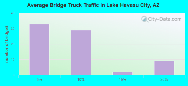
- 47,251Total average daily truck traffic
- National Bridge Inventory (NBI) Registered Bridges for Lake Havasu City
- No street view available for this location
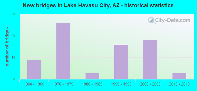
- New bridges - historical statistics
- 91960-1969
- 261970-1979
- 31980-1989
- 161990-1999
- 182000-2009
- 32010-2019
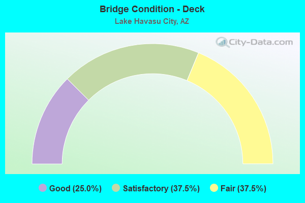
- Bridge Condition - Deck
- 25.0%Good
- 37.5%Satisfactory
- 37.5%Fair
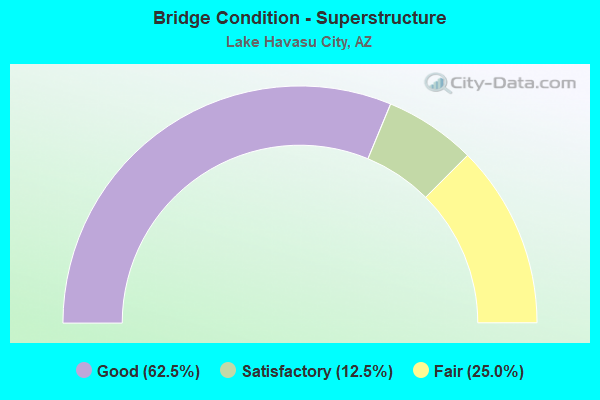
- Bridge Condition - Superstructure
- 62.5%Good
- 12.5%Satisfactory
- 25.0%Fair
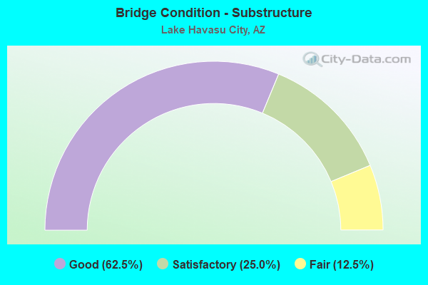
- Bridge Condition - Substructure
- 62.5%Good
- 25.0%Satisfactory
- 12.5%Fair
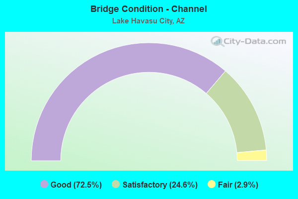
- Bridge Condition - Channel
- 72.5%Good
- 24.6%Satisfactory
- 2.9%Fair
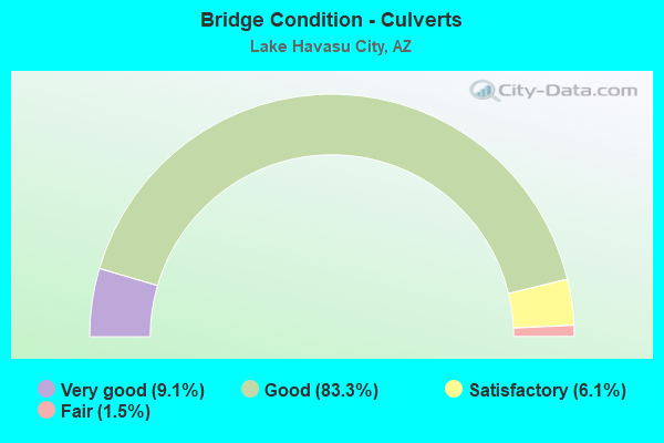
- Bridge Condition - Culverts
- 9.1%Very good
- 83.3%Good
- 6.1%Satisfactory
- 1.5%Fair
Find on map >> Show street view
Structure Number: 11037, Location: 0.7 mi E Jct PV Blvd S (Lat: 34.494400, Lng: -114.302500), Route carried "on" structure: City street , Year Built: 1995, Status: Open, Structure Length: 0.73m (2.40ft), Average Daily Traffic: 5,738 (year 2015), Truck Traffic: 1%, Average Future Daily Traffic: 5,748 (year 2038), Design Load: HS 20, Features Intersected: Iroquois Wash, Facility Carried by Structure: Kiowa Blvd S
Minimum Vertical Clearance: 7.62m (25.00ft), Kilometerpoint: 0.000, Lanes on structure: 2, Owner: City or Municipal Highway Agency, Approaching Roadway Width: 16.2m (53.1ft), Skew: 3 degrees, Material/Design: Steel, Design/Construction: Culvert, Number Of Spans In Main Unit: 4, Length of Maximum Span: 1.5m (4.9ft)
Condition: Channel: Good, Culverts: Good, Operating Rating: 64.4 metric tons, Method Used To Determine Operating Rating: Load Factor (LF), Inventory Rating: 37.2 metric tons, Method Used To Determine Inventory Rating: Load Factor (LF), Structural Evaluation: Better than present minimum criteria, Waterway Adequacy: Equal to present minimum criteria, Approach Roadway Alignment: Equal to present desirable criteria, Designated Inspection Frequency: Every 48 months, Inspection Date: Febuary 2018
Find on map >> Show street view
Structure Number: 11038, Location: 0.2 mi N Jct Jamaica Blvd (Lat: 34.503000, Lng: -114.292900), Route carried "on" structure: City street , Year Built: 1995, Status: Open, Structure Length: 0.70m (2.30ft), Average Daily Traffic: 2,631 (year 2020), Truck Traffic: 1%, Average Future Daily Traffic: 2,641 (year 2040), Design Load: HS 20, Features Intersected: Iroquois Wash, Facility Carried by Structure: Kiowa Blvd S
Minimum Vertical Clearance: 30+ m (98+ ft), Kilometerpoint: 0.000, Lanes on structure: 2, Owner: City or Municipal Highway Agency, Approaching Roadway Width: 13.4m (44.0ft), Material/Design: Steel, Design/Construction: Culvert, Number Of Spans In Main Unit: 4, Length of Maximum Span: 1.5m (4.9ft)
Condition: Channel: Good, Culverts: Good, Operating Rating: 64.4 metric tons, Method Used To Determine Operating Rating: Load Factor (LF), Inventory Rating: 37.2 metric tons, Method Used To Determine Inventory Rating: Load Factor (LF), Structural Evaluation: Better than present minimum criteria, Waterway Adequacy: Equal to present minimum criteria, Approach Roadway Alignment: Equal to present desirable criteria, Designated Inspection Frequency: Every 48 months, Inspection Date: Febuary 2018
Find on map >> Show street view
Structure Number: 11039, Location: 180 ft S Jct Willow Ave (Lat: 34.477900, Lng: -114.347400), Route carried "on" structure: City street , Year Built: 1997, Status: Open, Structure Length: 0.73m (2.40ft), Average Daily Traffic: 15,846 (year 2015), Truck Traffic: 1%, Average Future Daily Traffic: 15,856 (year 2038), Design Load: HS 20, Features Intersected: Willow Wash, Facility Carried by Structure: Lake Havasu Ave N
Minimum Vertical Clearance: 30+ m (98+ ft), Kilometerpoint: 0.000, Lanes on structure: 4, Owner: City or Municipal Highway Agency, Approaching Roadway Width: 16.5m (54.1ft), Material/Design: Steel, Design/Construction: Culvert, Number Of Spans In Main Unit: 5, Length of Maximum Span: 1.2m (3.9ft)
Condition: Channel: Good, Culverts: Satisfactory, Operating Rating: 89.8 metric tons, Method Used To Determine Operating Rating: Load Factor (LF), Inventory Rating: 89.8 metric tons, Method Used To Determine Inventory Rating: Load Factor (LF), Structural Evaluation: Equal to present minimum criteria, Waterway Adequacy: Equal to present minimum criteria, Approach Roadway Alignment: Equal to present desirable criteria, Designated Inspection Frequency: Every 48 months, Inspection Date: Febuary 2018
Find on map >> Show street view
Structure Number: 1104, Location: 150 ft N Jct Mulberry Ave (Lat: 34.463600, Lng: -114.334500), Route carried "on" structure: City street , Year Built: 2001, Status: Open, Structure Length: 0.76m (2.49ft), Average Daily Traffic: 6,334 (year 2017), Truck Traffic: 1%, Average Future Daily Traffic: 6,344 (year 2038), Design Load: HS 20, Features Intersected: Mulberry Drain, Facility Carried by Structure: Lake Havasu Ave S
Minimum Vertical Clearance: 30+ m (98+ ft), Kilometerpoint: 0.000, Lanes on structure: 5, Owner: City or Municipal Highway Agency, Approaching Roadway Width: 16.5m (54.1ft), Material/Design: Steel, Design/Construction: Culvert, Number Of Spans In Main Unit: 2, Length of Maximum Span: 3.0m (9.8ft)
Condition: Channel: Satisfactory, Culverts: Good, Operating Rating: 64.4 metric tons, Method Used To Determine Operating Rating: Load Factor (LF), Inventory Rating: 37.2 metric tons, Method Used To Determine Inventory Rating: Load Factor (LF), Structural Evaluation: Better than present minimum criteria, Waterway Adequacy: Equal to present minimum criteria, Approach Roadway Alignment: Equal to present desirable criteria, Designated Inspection Frequency: Every 48 months, Inspection Date: Febuary 2018
Find on map >> Show street view
Structure Number: 11041, Location: 0.1 mi S of Smoketree Ave (Lat: 34.467600, Lng: -114.337000), Route carried "on" structure: City street , Year Built: 2000, Status: Open, Structure Length: 0.98m (3.22ft), Average Daily Traffic: 6,334 (year 2017), Truck Traffic: 1%, Average Future Daily Traffic: 6,344 (year 2038), Design Load: HS 20, Features Intersected: Pima Wash, Facility Carried by Structure: Lake Havasu Ave S
Minimum Vertical Clearance: 30+ m (98+ ft), Kilometerpoint: 0.000, Lanes on structure: 3, Owner: City or Municipal Highway Agency, Approaching Roadway Width: 13.4m (44.0ft), Material/Design: Steel, Design/Construction: Culvert, Number Of Spans In Main Unit: 2, Length of Maximum Span: 4.3m (14.1ft)
Condition: Channel: Satisfactory, Culverts: Good, Operating Rating: 64.4 metric tons, Method Used To Determine Operating Rating: Load Factor (LF), Inventory Rating: 37.2 metric tons, Method Used To Determine Inventory Rating: Load Factor (LF), Structural Evaluation: Better than present minimum criteria, Waterway Adequacy: Equal to present minimum criteria, Approach Roadway Alignment: Equal to present desirable criteria, Designated Inspection Frequency: Every 48 months, Inspection Date: Febuary 2018
Find on map >> Show street view
Structure Number: 11043, Location: 0.4 mi S Jct Indstrl Blvd (Lat: 34.488600, Lng: -114.355200), Route carried "on" structure: City street , Year Built: 2005, Status: Open, Structure Length: 2.62m (8.60ft), Average Daily Traffic: 5,978 (year 2018), Truck Traffic: 1%, Average Future Daily Traffic: 5,988 (year 2038), Design Load: HS 20, Features Intersected: El Dorado Wash, Facility Carried by Structure: London Bridge Rd
Minimum Vertical Clearance: 7.62m (25.00ft), Kilometerpoint: 0.000, Lanes on structure: 2, Owner: City or Municipal Highway Agency, Approaching Roadway Width: 13.4m (44.0ft), Skew: 2 degrees, Material/Design: Steel, Design/Construction: Culvert, Number Of Spans In Main Unit: 11, Length of Maximum Span: 1.8m (5.9ft)
Condition: Channel: Good, Culverts: Good, Operating Rating: 64.4 metric tons, Method Used To Determine Operating Rating: Load Factor (LF), Inventory Rating: 37.2 metric tons, Method Used To Determine Inventory Rating: Load Factor (LF), Structural Evaluation: Better than present minimum criteria, Waterway Adequacy: Equal to present minimum criteria, Approach Roadway Alignment: Equal to present desirable criteria, Designated Inspection Frequency: Every 48 months, Inspection Date: Febuary 2018
Find on map >> Show street view
Structure Number: 11044, Location: 0.4 mi S Jct OroGrande Bl (Lat: 34.474500, Lng: -114.265200), Route carried "on" structure: City street , Year Built: 2005, Status: Open, Structure Length: 0.88m (2.89ft), Average Daily Traffic: 5,319 (year 2015), Truck Traffic: 1%, Average Future Daily Traffic: 5,329 (year 2038), Design Load: HS 20, Features Intersected: Lakeside Drain, Facility Carried by Structure: McCulloch Blvd
Minimum Vertical Clearance: 30+ m (98+ ft), Kilometerpoint: 0.000, Lanes on structure: 2, Owner: City or Municipal Highway Agency, Approaching Roadway Width: 14.9m (48.9ft), Skew: 4 degrees, Material/Design: Steel, Design/Construction: Culvert, Number Of Spans In Main Unit: 4, Length of Maximum Span: 1.5m (4.9ft)
Condition: Channel: Good, Culverts: Good, Operating Rating: 64.4 metric tons, Method Used To Determine Operating Rating: Load Factor (LF), Inventory Rating: 37.2 metric tons, Method Used To Determine Inventory Rating: Load Factor (LF), Structural Evaluation: Better than present minimum criteria, Waterway Adequacy: Equal to present minimum criteria, Approach Roadway Alignment: Equal to present desirable criteria, Designated Inspection Frequency: Every 48 months, Inspection Date: Febuary 2018
Find on map >> Show street view
Structure Number: 11045, Location: 0.3 mi W Jct Acoma Bl N (Lat: 34.475200, Lng: -114.327600), Route carried "on" structure: City street , Year Built: 1999, Status: Open, Structure Length: 1.31m (4.30ft), Average Daily Traffic: 10,180 (year 2016), Truck Traffic: 1%, Average Future Daily Traffic: 10,190 (year 2038), Design Load: HS 20, Features Intersected: Pima Wash, Facility Carried by Structure: McCulloch Blvd
Minimum Vertical Clearance: 7.62m (25.00ft), Kilometerpoint: 0.000, Lanes on structure: 2, Owner: City or Municipal Highway Agency, Approaching Roadway Width: 18.0m (59.1ft), Material/Design: Concrete continuous, Design/Construction: Culvert, Number Of Spans In Main Unit: 4, Length of Maximum Span: 3.0m (9.8ft)
Condition: Channel: Good, Culverts: Good, Operating Rating: 49.9 metric tons, Method Used To Determine Operating Rating: Load Factor (LF), Inventory Rating: 29.9 metric tons, Method Used To Determine Inventory Rating: Load Factor (LF), Structural Evaluation: Better than present minimum criteria, Waterway Adequacy: Equal to present minimum criteria, Approach Roadway Alignment: Equal to present desirable criteria, Designated Inspection Frequency: Every 48 months, Inspection Date: Febuary 2018
Find on map >> Show street view
Structure Number: 11046, Location: 0.6 mi S Jct OroGrande Bl (Lat: 34.473000, Lng: -114.263800), Route carried "on" structure: City street , Year Built: 2005, Status: Open, Structure Length: 1.83m (6.00ft), Average Daily Traffic: 2,982 (year 2015), Truck Traffic: 1%, Average Future Daily Traffic: 2,992 (year 2038), Design Load: HS 20, Features Intersected: Mockingbird Wash, Facility Carried by Structure: McCulloch Blvd
Minimum Vertical Clearance: 30+ m (98+ ft), Kilometerpoint: 0.000, Lanes on structure: 2, Owner: City or Municipal Highway Agency, Approaching Roadway Width: 9.4m (30.8ft), Material/Design: Steel, Design/Construction: Culvert, Number Of Spans In Main Unit: 7, Length of Maximum Span: 1.8m (5.9ft)
Condition: Channel: Good, Culverts: Good, Operating Rating: 64.4 metric tons, Method Used To Determine Operating Rating: Load Factor (LF), Inventory Rating: 37.2 metric tons, Method Used To Determine Inventory Rating: Load Factor (LF), Structural Evaluation: Better than present minimum criteria, Waterway Adequacy: Equal to present minimum criteria, Approach Roadway Alignment: Equal to present desirable criteria, Designated Inspection Frequency: Every 48 months, Inspection Date: Febuary 2018
Find on map >> Show street view
Structure Number: 11047, Location: 0.2 mi W Jct Acoma Blvd S (Lat: 34.476900, Lng: -114.327400), Route carried "on" structure: City street , Year Built: 1996, Status: Open, Structure Length: 1.65m (5.41ft), Average Daily Traffic: 7,288 (year 2015), Truck Traffic: 1%, Average Future Daily Traffic: 7,298 (year 2038), Design Load: HS 20, Features Intersected: Pima Wash, Facility Carried by Structure: Mesquite Ave
Minimum Vertical Clearance: 7.62m (25.00ft), Kilometerpoint: 0.000, Lanes on structure: 2, Owner: City or Municipal Highway Agency, Approaching Roadway Width: 14.3m (46.9ft), Material/Design: Concrete continuous, Design/Construction: Culvert, Number Of Spans In Main Unit: 5, Length of Maximum Span: 3.0m (9.8ft)
Condition: Channel: Good, Culverts: Good, Operating Rating: 89.8 metric tons, Method Used To Determine Operating Rating: Load Factor (LF), Inventory Rating: 77.1 metric tons, Method Used To Determine Inventory Rating: Load Factor (LF), Structural Evaluation: Better than present minimum criteria, Waterway Adequacy: Equal to present minimum criteria, Approach Roadway Alignment: Equal to present desirable criteria, Designated Inspection Frequency: Every 48 months, Inspection Date: Febuary 2018
Find on map >> Show street view
Structure Number: 11048, Location: 0.3 mi S Jct Kiowa Blvd N (Lat: 34.514300, Lng: -114.297500), Route carried "on" structure: City street , Year Built: 2002, Status: Open, Structure Length: 1.07m (3.51ft), Average Daily Traffic: 5,095 (year 2015), Truck Traffic: 1%, Average Future Daily Traffic: 5,105 (year 2038), Design Load: HS 20, Features Intersected: Palmtree Wash, Facility Carried by Structure: Palo Verde Blvd S
Minimum Vertical Clearance: 7.62m (25.00ft), Kilometerpoint: 0.000, Lanes on structure: 2, Owner: City or Municipal Highway Agency, Approaching Roadway Width: 13.4m (44.0ft), Material/Design: Steel, Design/Construction: Culvert, Number Of Spans In Main Unit: 6, Length of Maximum Span: 1.5m (4.9ft)
Condition: Channel: Good, Culverts: Good, Operating Rating: 89.8 metric tons, Method Used To Determine Operating Rating: Load Factor (LF), Inventory Rating: 89.8 metric tons, Method Used To Determine Inventory Rating: Load Factor (LF), Structural Evaluation: Better than present minimum criteria, Waterway Adequacy: Equal to present minimum criteria, Approach Roadway Alignment: Equal to present desirable criteria, Designated Inspection Frequency: Every 48 months, Inspection Date: Febuary 2018
Find on map >> Show street view
Structure Number: 11049, Location: 0.3 mi N Jct Kiowa Blvd N (Lat: 34.522400, Lng: -114.300400), Route carried "on" structure: City street , Year Built: 2001, Status: Open, Structure Length: 0.88m (2.89ft), Average Daily Traffic: 2,845 (year 2015), Truck Traffic: 1%, Average Future Daily Traffic: 2,855 (year 2038), Design Load: HS 20, Features Intersected: Havasupai Wash, Facility Carried by Structure: Palo Verde Blvd N
Minimum Vertical Clearance: 7.62m (25.00ft), Kilometerpoint: 0.000, Lanes on structure: 2, Owner: City or Municipal Highway Agency, Approaching Roadway Width: 13.4m (44.0ft), Material/Design: Steel, Design/Construction: Culvert, Number Of Spans In Main Unit: 5, Length of Maximum Span: 1.5m (4.9ft)
Condition: Channel: Satisfactory, Culverts: Good, Operating Rating: 64.4 metric tons, Method Used To Determine Operating Rating: Load Factor (LF), Inventory Rating: 37.2 metric tons, Method Used To Determine Inventory Rating: Load Factor (LF), Structural Evaluation: Better than present minimum criteria, Waterway Adequacy: Equal to present minimum criteria, Approach Roadway Alignment: Equal to present desirable criteria, Designated Inspection Frequency: Every 48 months, Inspection Date: Febuary 2018
Find on map >> Show street view
Structure Number: 1105, Location: 290 ft S Jct Kiowa Blvd S (Lat: 34.493400, Lng: -114.315700), Route carried "on" structure: City street , Year Built: 1996, Status: Open, Structure Length: 2.59m (8.50ft), Average Daily Traffic: 6,636 (year 2015), Truck Traffic: 1%, Average Future Daily Traffic: 6,646 (year 2038), Design Load: HS 20, Features Intersected: El Dorado Wash, Facility Carried by Structure: Palo Verde Blvd S
Minimum Vertical Clearance: 7.62m (25.00ft), Kilometerpoint: 0.000, Lanes on structure: 4, Owner: City or Municipal Highway Agency, Approaching Roadway Width: 16.5m (54.1ft), Skew: 4 degrees, Material/Design: Steel, Design/Construction: Culvert, Number Of Spans In Main Unit: 8, Length of Maximum Span: 1.5m (4.9ft)
Condition: Channel: Satisfactory, Culverts: Good, Operating Rating: 89.8 metric tons, Method Used To Determine Operating Rating: Load Factor (LF), Inventory Rating: 89.8 metric tons, Method Used To Determine Inventory Rating: Load Factor (LF), Structural Evaluation: Better than present minimum criteria, Waterway Adequacy: Equal to present minimum criteria, Approach Roadway Alignment: Equal to present desirable criteria, Designated Inspection Frequency: Every 48 months, Inspection Date: Febuary 2018
Find on map >> Show street view
Structure Number: 11051, Location: 0.6 mi E Jct Acoma Blvd S (Lat: 34.461100, Lng: -114.291200), Route carried "on" structure: City street , Year Built: 1997, Status: Open, Structure Length: 2.04m (6.69ft), Average Daily Traffic: 1,788 (year 2011), Truck Traffic: 1%, Average Future Daily Traffic: 1,798 (year 2038), Design Load: HS 20, Features Intersected: Chemehuevi Wash, Facility Carried by Structure: Southwind Ave
Minimum Vertical Clearance: 7.62m (25.00ft), Kilometerpoint: 0.000, Lanes on structure: 2, Owner: City or Municipal Highway Agency, Approaching Roadway Width: 12.8m (42.0ft), Material/Design: Steel, Design/Construction: Culvert, Number Of Spans In Main Unit: 10, Length of Maximum Span: 1.5m (4.9ft)
Condition: Channel: Good, Culverts: Good, Operating Rating: 89.8 metric tons, Method Used To Determine Operating Rating: Load Factor (LF), Inventory Rating: 89.8 metric tons, Method Used To Determine Inventory Rating: Load Factor (LF), Structural Evaluation: Better than present minimum criteria, Waterway Adequacy: Better than present minimum criteria, Approach Roadway Alignment: Equal to present desirable criteria, Designated Inspection Frequency: Every 48 months, Inspection Date: Febuary 2018
Find on map >> Show street view
Structure Number: 11052, Location: 0.2 mi N Jct OroGrande Bl (Lat: 34.462900, Lng: -114.281200), Route carried "on" structure: City street , Year Built: 2008, Status: Open, Structure Length: 1.22m (4.00ft), Average Daily Traffic: 2,540 (year 2018), Average Future Daily Traffic: 2,550 (year 2038), Design Load: HS 20, Features Intersected: Mockingbird Wash, Facility Carried by Structure: Thunderbolt Ave
Minimum Vertical Clearance: 7.62m (25.00ft), Kilometerpoint: 0.000, Lanes on structure: 2, Owner: City or Municipal Highway Agency, Approaching Roadway Width: 12.8m (42.0ft), Material/Design: Steel, Design/Construction: Culvert, Number Of Spans In Main Unit: 6, Length of Maximum Span: 1.5m (4.9ft)
Condition: Channel: Satisfactory, Culverts: Good, Operating Rating: 89.8 metric tons, Method Used To Determine Operating Rating: Load Factor (LF), Inventory Rating: 89.8 metric tons, Method Used To Determine Inventory Rating: Load Factor (LF), Structural Evaluation: Better than present minimum criteria, Waterway Adequacy: Better than present minimum criteria, Approach Roadway Alignment: Equal to present desirable criteria, Designated Inspection Frequency: Every 48 months, Inspection Date: Febuary 2018
Find on map >> Show street view
Structure Number: 11053, Location: 0.5 mi S Chemehuevi Blvd (Lat: 34.468000, Lng: -114.287800), Route carried "on" structure: City street , Year Built: 1995, Status: Open, Structure Length: 1.04m (3.41ft), Average Daily Traffic: 3,726 (year 2018), Truck Traffic: 1%, Average Future Daily Traffic: 3,736 (year 2038), Design Load: HS 20, Features Intersected: Chemehuevi Wash, Facility Carried by Structure: Thunderbolt Ave
Minimum Vertical Clearance: 7.62m (25.00ft), Kilometerpoint: 0.000, Lanes on structure: 2, Owner: City or Municipal Highway Agency, Approaching Roadway Width: 13.4m (44.0ft), Material/Design: Steel, Design/Construction: Culvert, Number Of Spans In Main Unit: 6, Length of Maximum Span: 1.2m (3.9ft)
Condition: Channel: Good, Culverts: Good, Operating Rating: 64.4 metric tons, Method Used To Determine Operating Rating: Load Factor (LF), Inventory Rating: 37.2 metric tons, Method Used To Determine Inventory Rating: Load Factor (LF), Structural Evaluation: Better than present minimum criteria, Waterway Adequacy: Better than present minimum criteria, Approach Roadway Alignment: Equal to present desirable criteria, Designated Inspection Frequency: Every 48 months, Inspection Date: Febuary 2018
Find on map >> Show street view
Structure Number: 11054, Location: W of LHC Airport (Lat: 34.565000, Lng: -114.360900), Route carried "on" structure: City street , Year Built: 2008, Status: Open, Structure Length: 0.98m (3.22ft), Average Daily Traffic: 200 (year 2018), Truck Traffic: 1%, Average Future Daily Traffic: 210 (year 2038), Design Load: HS 20, Features Intersected: Wash, Facility Carried by Structure: Whelan Dr
Minimum Vertical Clearance: 30+ m (98+ ft), Kilometerpoint: 0.000, Lanes on structure: 2, Owner: City or Municipal Highway Agency, Approaching Roadway Width: 7.3m (24.0ft), Material/Design: Steel, Design/Construction: Culvert, Number Of Spans In Main Unit: 3, Length of Maximum Span: 3.0m (9.8ft)
Condition: Channel: Good, Culverts: Good, Operating Rating: 62.6 metric tons, Method Used To Determine Operating Rating: Load Factor (LF), Inventory Rating: 37.2 metric tons, Method Used To Determine Inventory Rating: Load Factor (LF), Structural Evaluation: Better than present minimum criteria, Waterway Adequacy: Equal to present desirable criteria, Approach Roadway Alignment: Equal to present desirable criteria, Designated Inspection Frequency: Every 48 months, Inspection Date: Febuary 2018
Find on map >> Show street view
Structure Number: 11055, Location: 0.04 mi S of Chemehuevi (Lat: 34.483100, Lng: -114.267900), Route carried "on" structure: City street , Year Built: 2005, Status: Open, Structure Length: 1.65m (5.41ft), Average Daily Traffic: 5,319 (year 2015), Truck Traffic: 1%, Average Future Daily Traffic: 5,329 (year 2038), Design Load: HS 20, Features Intersected: Chemehuevi Wash, Facility Carried by Structure: McCulloch Blvd S
Minimum Vertical Clearance: 6.10m (20.01ft), Kilometerpoint: 0.000, Lanes on structure: 2, Owner: City or Municipal Highway Agency, Approaching Roadway Width: 14.9m (48.9ft), Material/Design: Steel, Design/Construction: Culvert, Number Of Spans In Main Unit: 8, Length of Maximum Span: 1.5m (4.9ft)
Condition: Channel: Satisfactory, Culverts: Good, Operating Rating: 89.8 metric tons, Method Used To Determine Operating Rating: Load Factor (LF), Inventory Rating: 89.8 metric tons, Method Used To Determine Inventory Rating: Load Factor (LF), Structural Evaluation: Better than present minimum criteria, Waterway Adequacy: Better than present minimum criteria, Approach Roadway Alignment: Equal to present desirable criteria, Designated Inspection Frequency: Every 48 months, Inspection Date: Febuary 2018
Find on map >> Show street view
Structure Number: 11056, Location: 0.1 mi E Jct SR 95 (Lat: 34.546400, Lng: -114.353900), Route carried "on" structure: City street , Year Built: 2004, Status: Open, Structure Length: 0.76m (2.49ft), Average Daily Traffic: 1,390 (year 2015), Truck Traffic: 1%, Average Future Daily Traffic: 1,400 (year 2038), Design Load: HS 20, Features Intersected: Wash, Facility Carried by Structure: Chenoweth Dr
Minimum Vertical Clearance: 30+ m (98+ ft), Kilometerpoint: 0.000, Lanes on structure: 4, Owner: City or Municipal Highway Agency, Approaching Roadway Width: 21.3m (69.9ft), Skew: 1 degrees, Material/Design: Concrete, Design/Construction: Culvert, Number Of Spans In Main Unit: 1, Length of Maximum Span: 7.3m (24.0ft)
Condition: Channel: Satisfactory, Culverts: Good, Operating Rating: 89.8 metric tons, Method Used To Determine Operating Rating: Load Factor (LF), Inventory Rating: 89.8 metric tons, Method Used To Determine Inventory Rating: Load Factor (LF), Structural Evaluation: Better than present minimum criteria, Waterway Adequacy: Better than present minimum criteria, Approach Roadway Alignment: Equal to present desirable criteria, Designated Inspection Frequency: Every 48 months, Inspection Date: Febuary 2018
Find on map >> Show street view
Structure Number: 11057, Location: 0.3 mi. E Jct Lake Havasu (Lat: 34.496200, Lng: -114.341700), Route carried "on" structure: City street , Year Built: 1995, Status: Open, Structure Length: 0.67m (2.20ft), Average Daily Traffic: 7,722 (year 2017), Truck Traffic: 1%, Average Future Daily Traffic: 7,732 (year 2038), Design Load: HS 20, Features Intersected: Malibu Drain, Facility Carried by Structure: Acoma Blvd
Minimum Vertical Clearance: 6.10m (20.01ft), Kilometerpoint: 0.000, Lanes on structure: 2, Owner: City or Municipal Highway Agency, Approaching Roadway Width: 16.5m (54.1ft), Material/Design: Concrete continuous, Design/Construction: Culvert, Number Of Spans In Main Unit: 2, Length of Maximum Span: 3.0m (9.8ft)
Condition: Channel: Satisfactory, Culverts: Good, Operating Rating: 52.6 metric tons, Method Used To Determine Operating Rating: Load Factor (LF), Inventory Rating: 31.8 metric tons, Method Used To Determine Inventory Rating: Load Factor (LF), Structural Evaluation: Better than present minimum criteria, Waterway Adequacy: Equal to present minimum criteria, Approach Roadway Alignment: Equal to present desirable criteria, Designated Inspection Frequency: Every 48 months, Inspection Date: Febuary 2018
Find on map >> Show street view
Structure Number: 11058, Location: 0.8 mi N Jct Kiowa Blvd N (Lat: 34.509300, Lng: -114.348000), Route carried "on" structure: City street , Year Built: 2007, Status: Open, Structure Length: 2.01m (6.59ft), Average Daily Traffic: 4,772 (year 2016), Truck Traffic: 1%, Average Future Daily Traffic: 4,782 (year 2038), Design Load: HS 20, Features Intersected: Havasupai Wash, Facility Carried by Structure: Lake Havasu Ave N
Minimum Vertical Clearance: 30+ m (98+ ft), Kilometerpoint: 0.000, Lanes on structure: 2, Owner: City or Municipal Highway Agency, Approaching Roadway Width: 12.8m (42.0ft), Skew: 1 degrees, Material/Design: Concrete continuous, Design/Construction: Culvert, Number Of Spans In Main Unit: 3, Length of Maximum Span: 6.1m (20.0ft)
Condition: Channel: Good, Culverts: Very good, Operating Rating: 64.4 metric tons, Method Used To Determine Operating Rating: Load Factor (LF), Inventory Rating: 37.2 metric tons, Method Used To Determine Inventory Rating: Load Factor (LF), Structural Evaluation: Equal to present desirable criteria, Waterway Adequacy: Better than present minimum criteria, Approach Roadway Alignment: Equal to present desirable criteria, Designated Inspection Frequency: Every 48 months, Inspection Date: Febuary 2018
Find on map >> Show street view
Structure Number: 11076, Location: 0.1 mi E Jct McCulloch Bl (Lat: 34.473861, Lng: -114.262417), Route carried "on" structure: County highway , Year Built: 2000, Status: Open, Structure Length: 0.79m (2.59ft), Average Daily Traffic: 200 (year 2019), Average Future Daily Traffic: 210 (year 2039), Design Load: HS 20, Features Intersected: Wash, Facility Carried by Structure: Little Finger Rd
Minimum Vertical Clearance: 30+ m (98+ ft), Kilometerpoint: 0.000, Lanes on structure: 2, Owner: County Highway Agency, Approaching Roadway Width: 7.3m (24.0ft), Skew: 1 degrees, Material/Design: Concrete continuous, Design/Construction: Culvert, Number Of Spans In Main Unit: 2, Length of Maximum Span: 3.7m (12.1ft)
Condition: Channel: Good, Culverts: Good, Operating Rating: 89.8 metric tons, Method Used To Determine Operating Rating: Load Factor (LF), Inventory Rating: 89.8 metric tons, Method Used To Determine Inventory Rating: Load Factor (LF), Structural Evaluation: Better than present minimum criteria, Waterway Adequacy: Better than present minimum criteria, Approach Roadway Alignment: Equal to present desirable criteria, Designated Inspection Frequency: Every 48 months, Inspection Date: September 2019
Find on map >> Show street view
Structure Number: 11157, Location: 1.0 mi S Jct McCulloch Bl (Lat: 34.468700, Lng: -114.272200), Route carried "on" structure: City street , Year Built: 2011, Status: Open, Structure Length: 1.65m (5.41ft), Average Daily Traffic: 2,919 (year 2015), Truck Traffic: 1%, Average Future Daily Traffic: 2,929 (year 2038), Design Load: HS 20, Features Intersected: Mockingbird Wash, Facility Carried by Structure: Oro Grande Blvd
Minimum Vertical Clearance: 30+ m (98+ ft), Kilometerpoint: 0.000, Lanes on structure: 2, Owner: City or Municipal Highway Agency, Approaching Roadway Width: 15.8m (51.8ft), Material/Design: Concrete continuous, Design/Construction: Culvert, Number Of Spans In Main Unit: 5, Length of Maximum Span: 3.0m (9.8ft)
Condition: Channel: Satisfactory, Culverts: Very good, Operating Rating: 49.9 metric tons, Method Used To Determine Operating Rating: Load Factor (LF), Inventory Rating: 29.9 metric tons, Method Used To Determine Inventory Rating: Load Factor (LF), Structural Evaluation: Better than present minimum criteria, Waterway Adequacy: Equal to present desirable criteria, Approach Roadway Alignment: Equal to present desirable criteria, Designated Inspection Frequency: Every 48 months, Inspection Date: Febuary 2020, Deck Structure Type: Concrete Cast-file-Place
Find on map >> Show street view
Structure Number: 11158, Location: 0.5 mi W Jct Acoma Blvd S (Lat: 34.473900, Lng: -114.328800), Route carried "on" structure: City street , Year Built: 2011, Status: Open, Structure Length: 1.31m (4.30ft), Average Daily Traffic: 9,982 (year 2015), Truck Traffic: 1%, Average Future Daily Traffic: 9,992 (year 2038), Design Load: HS 20, Features Intersected: Pima Wash, Facility Carried by Structure: Swanson Ave
Minimum Vertical Clearance: 6.10m (20.01ft), Kilometerpoint: 0.000, Lanes on structure: 2, Owner: City or Municipal Highway Agency, Approaching Roadway Width: 14.0m (45.9ft), Material/Design: Concrete continuous, Design/Construction: Culvert, Number Of Spans In Main Unit: 4, Length of Maximum Span: 3.0m (9.8ft)
Condition: Channel: Good, Culverts: Very good, Operating Rating: 49.9 metric tons, Method Used To Determine Operating Rating: Load Factor (LF), Inventory Rating: 29.9 metric tons, Method Used To Determine Inventory Rating: Load Factor (LF), Structural Evaluation: Better than present minimum criteria, Waterway Adequacy: Equal to present desirable criteria, Approach Roadway Alignment: Equal to present desirable criteria, Designated Inspection Frequency: Every 48 months, Inspection Date: Febuary 2020, Deck Structure Type: Concrete Cast-file-Place, Wearing Surface/Protective System: Wearing Surface: Bituminous
Find on map >> Show street view
Structure Number: 11159, Location: 450 ft S Jct Kiowa Blvd S (Lat: 34.494100, Lng: -114.298300), Route carried "on" structure: City street , Year Built: 2011, Status: Open, Structure Length: 1.65m (5.41ft), Average Daily Traffic: 3,205 (year 2018), Truck Traffic: 1%, Average Future Daily Traffic: 3,215 (year 2038), Design Load: HS 20, Features Intersected: El Dorado Wash, Facility Carried by Structure: Bermuda Ave
Minimum Vertical Clearance: 30+ m (98+ ft), Kilometerpoint: 0.000, Lanes on structure: 2, Owner: City or Municipal Highway Agency, Approaching Roadway Width: 13.4m (44.0ft), Material/Design: Concrete continuous, Design/Construction: Culvert, Number Of Spans In Main Unit: 5, Length of Maximum Span: 3.0m (9.8ft)
Condition: Channel: Good, Culverts: Very good, Operating Rating: 53.5 metric tons, Method Used To Determine Operating Rating: Load Factor (LF), Inventory Rating: 31.8 metric tons, Method Used To Determine Inventory Rating: Load Factor (LF), Structural Evaluation: Better than present minimum criteria, Waterway Adequacy: Equal to present desirable criteria, Approach Roadway Alignment: Equal to present desirable criteria, Designated Inspection Frequency: Every 48 months, Inspection Date: Febuary 2020, Deck Structure Type: Concrete Cast-file-Place, Wearing Surface/Protective System: Wearing Surface: Monolithic Concrete
Find on map >> Show street view
Structure Number: 1824, Location: 19.6 mi S I 40 (Lat: 34.473200, Lng: -114.345400), Route carried "under" structure: State highway 95, Year Built: 1977, Structure Length: 0. m, Average Daily Traffic: 22,553 (year 2018), Truck Traffic: 7%, Features Intersected: SR 95, Facility Carried by Structure: IRR McCulloch Blvd
Minimum Vertical Clearance: 5.34m (17.52ft), Kilometerpoint: 293.512, Lanes on structure: 3, Lanes under structure: 3, Material/Design: Prestressed concrete, Design/Construction: Box Beam or Girders - Single/Spread, Length of Maximum Span: 38.4m (126.0ft)