Bridge Statistics for Kearney, Nebraska (NE)
Condition, Traffic, Stress, Structural Evaluation, Project Costs
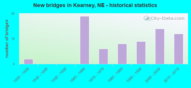
- New bridges - historical statistics
- 21930-1939
- 191960-1969
- 61970-1979
- 81980-1989
- 91990-1999
- 142000-2009
- 122010-2019
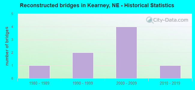
- Reconstructed bridges - Historical Statistics
- 11980-1989
- 21990-1999
- 42000-2009
- 12010-2019
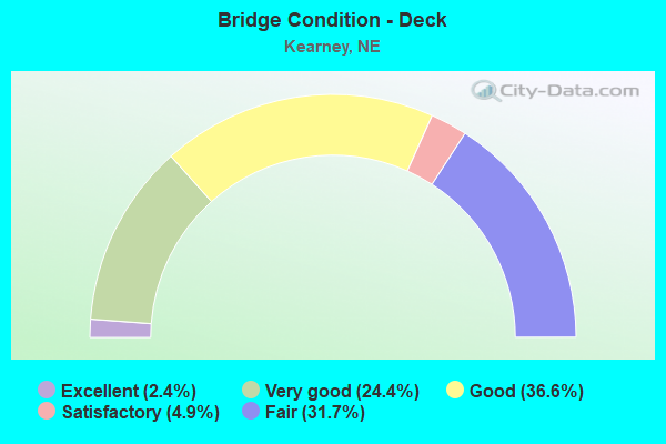
- Bridge Condition - Deck
- 2.4%Excellent
- 24.4%Very good
- 36.6%Good
- 4.9%Satisfactory
- 31.7%Fair
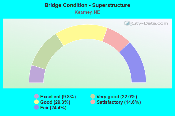
- Bridge Condition - Superstructure
- 9.8%Excellent
- 22.0%Very good
- 29.3%Good
- 14.6%Satisfactory
- 24.4%Fair
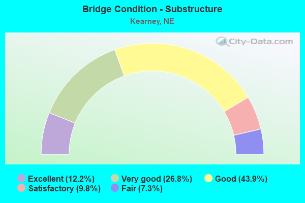
- Bridge Condition - Substructure
- 12.2%Excellent
- 26.8%Very good
- 43.9%Good
- 9.8%Satisfactory
- 7.3%Fair
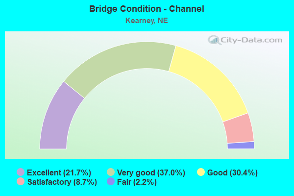
- Bridge Condition - Channel
- 21.7%Excellent
- 37.0%Very good
- 30.4%Good
- 8.7%Satisfactory
- 2.2%Fair
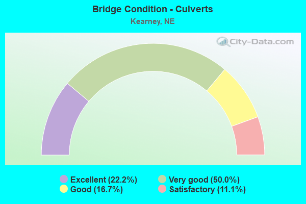
- Bridge Condition - Culverts
- 22.2%Excellent
- 50.0%Very good
- 16.7%Good
- 11.1%Satisfactory
Find on map >> Show street view
Structure Number: U135003701, Location: KEARNEY H AVE @ 21ST ST (Lat: 40.697200, Lng: -99.072200), Route carried "on" structure: City street 5931, Year Built: 1985, Status: Open, Structure Length: 17.47m (57.32ft), Average Daily Traffic: 4,215 (year 2012), Average Future Daily Traffic: 5,340 (year 2033), Design Load: HS 20, Features Intersected: 21ST ST UPRR, Facility Carried by Structure: H AVE
Minimum Vertical Clearance: 30+ m (98+ ft), Kilometerpoint: 16.230, Lanes on structure: 2, Lanes under structure: 4, Owner: City or Municipal Highway Agency, Approaching Roadway Width: 9.1m (29.9ft), Skew: 1 degrees, Material/Design: Steel continuous, Design/Construction: Stringer/Multi-beam, Number Of Spans In Main Unit: 5, Length of Maximum Span: 41.1m (134.8ft), Curb or Sidewalk Widths: Left: 0.4m (1.3ft), Right: 2.1m (6.9ft), Curb-To-Curb Width: 9.1m (29.9ft), Out-to-Out Width: 11.7m (38.4ft)
Condition: Deck: Very good, Superstructure: Very good, Substructure: Very good, Operating Rating: 82.0 metric tons, Method Used To Determine Operating Rating: Load Factor (LF), Inventory Rating: 49.0 metric tons, Method Used To Determine Inventory Rating: Load Factor (LF), Structural Evaluation: Equal to present desirable criteria, Deck Geometry: Meets minimum limits, Underclear: Somewhat better than minimum adequacy, Approach Roadway Alignment: Equal to present desirable criteria, Designated Inspection Frequency: Every 24 months, Inspection Date: November 2020, Deck Structure Type: Concrete Cast-file-Place, Wearing Surface/Protective System: Wearing Surface: Monolithic Concrete, Deck Protection: Epoxy Coated Reinforcing
Find on map >> Show street view
Structure Number: U135003905, Location: .7S 11TH & AVE M (Lat: 40.674900, Lng: -99.066400), Route carried "on" structure: City street 39, Year Built: 1994, Status: Open, Structure Length: 2.07m (6.79ft), Average Daily Traffic: 100 (year 1997), Truck Traffic: 10%, Average Future Daily Traffic: 145 (year 2033), Design Load: HS 20, Features Intersected: PLATTE RIVER N CHANNEL, Facility Carried by Structure: AVE M
Minimum Vertical Clearance: 30+ m (98+ ft), Kilometerpoint: 0.000, Lanes on structure: 2, Owner: City or Municipal Highway Agency, Approaching Roadway Width: 8.5m (27.9ft), Material/Design: Steel, Design/Construction: Stringer/Multi-beam, Number Of Spans In Main Unit: 1, Length of Maximum Span: 19.8m (65.0ft), Curb-To-Curb Width: 8.6m (28.2ft), Out-to-Out Width: 9.3m (30.5ft)
Condition: Deck: Good, Superstructure: Very good, Substructure: Very good, Channel: Satisfactory, Operating Rating: 38.0 metric tons, Method Used To Determine Operating Rating: Load Factor (LF), Inventory Rating: 23.0 metric tons, Method Used To Determine Inventory Rating: Load Factor (LF), Structural Evaluation: Equal to present minimum criteria, Deck Geometry: Better than present minimum criteria, Waterway Adequacy: Better than present minimum criteria, Approach Roadway Alignment: Equal to present desirable criteria, Designated Inspection Frequency: Every 24 months, Inspection Date: November 2020, Deck Structure Type: Concrete Cast-file-Place, Wearing Surface/Protective System: Wearing Surface: Monolithic Concrete, Membrane: Built-up, Deck Protection: Galvanized Reinforcing
Find on map >> Show street view
Structure Number: U13500392, Location: AVE M KEARNEY (Lat: 40.699000, Lng: -99.065900), Route carried "on" structure: City street 5923, Year Built: 2002, Status: Open, Structure Length: 38.89m (127.59ft), Average Daily Traffic: 4,525 (year 2012), Truck Traffic: 2%, Average Future Daily Traffic: 4,190 (year 2033), Design Load: HS 20, Features Intersected: N RR ST/HWY 30/UPRR, Facility Carried by Structure: AVE M
Minimum Vertical Clearance: 30+ m (98+ ft), Kilometerpoint: 16.093, Lanes on structure: 2, Lanes under structure: 4, Owner: City or Municipal Highway Agency, Approaching Roadway Width: 9.8m (32.2ft), Skew: 1 degrees, Material/Design: Prestressed concrete, Design/Construction: Stringer/Multi-beam, Number Of Spans In Main Unit: 10, Length of Maximum Span: 46.9m (153.9ft), Curb or Sidewalk Widths: Left: 2.4m (7.9ft), Right: 0.0m, Curb-To-Curb Width: 9.8m (32.2ft), Out-to-Out Width: 13.2m (43.3ft)
Condition: Deck: Very good, Superstructure: Very good, Substructure: Very good, Operating Rating: 90.0 metric tons, Method Used To Determine Operating Rating: Load Factor (LF), Inventory Rating: 34.0 metric tons, Method Used To Determine Inventory Rating: Load Factor (LF), Structural Evaluation: Equal to present desirable criteria, Deck Geometry: Meets minimum limits, Underclear: Superior to present desirable criteria, Approach Roadway Alignment: Equal to present desirable criteria, Designated Inspection Frequency: Every 24 months, Inspection Date: November 2020, Deck Structure Type: Concrete Cast-file-Place, Wearing Surface/Protective System: Wearing Surface: Monolithic Concrete, Deck Protection: Epoxy Coated Reinforcing
Find on map >> Show street view
Structure Number: U135004305, Location: 1S 11TH & CHERRY AVE (Lat: 40.673000, Lng: -99.028000), Route carried "on" structure: Other road , Year Built: 1975, Status: Open, Structure Length: 1.55m (5.09ft), Average Daily Traffic: 10 (year 1997), Average Future Daily Traffic: 14 (year 2033), Features Intersected: N CH PLATTE RIVER, Facility Carried by Structure: CHERRY AVE
Minimum Vertical Clearance: 30+ m (98+ ft), Kilometerpoint: 0.000, Lanes on structure: 1, Owner: City or Municipal Highway Agency, Approaching Roadway Width: 3.0m (9.8ft), Material/Design: Prestressed concrete, Design/Construction: Tee Beam, Number Of Spans In Main Unit: 2, Length of Maximum Span: 7.6m (24.9ft), Curb-To-Curb Width: 4.6m (15.1ft), Out-to-Out Width: 4.6m (15.1ft)
Condition: Deck: Good, Superstructure: Good, Substructure: Satisfactory, Channel: Satisfactory, Operating Rating: 72.0 metric tons, Method Used To Determine Operating Rating: Load Factor (LF), Inventory Rating: 43.0 metric tons, Method Used To Determine Inventory Rating: Load Factor (LF), Structural Evaluation: Equal to present minimum criteria, Deck Geometry: Better than present minimum criteria, Waterway Adequacy: Equal to present minimum criteria, Approach Roadway Alignment: High priority of corrective action, Length Of Structure Improvement: 1.55m (5.09ft), Designated Inspection Frequency: Every 24 months, Inspection Date: November 2018, Deck Structure Type: Concrete Precast Panels, Wearing Surface/Protective System: Wearing Surface: Monolithic Concrete
Find on map >> Show street view
Structure Number: U135005205, Location: .3S 56TH & AVE E (Lat: 40.725900, Lng: -99.074300), Route carried "on" structure: City street 5919, Year Built: 2001, Status: Open, Structure Length: 0.67m (2.20ft), Average Daily Traffic: 1,600 (year 2004), Average Future Daily Traffic: 1,760 (year 2033), Design Load: HS 20, Features Intersected: WOOD RIVER TRIB, Facility Carried by Structure: AVE E
Minimum Vertical Clearance: 30+ m (98+ ft), Kilometerpoint: 0.177, Lanes on structure: 2, Owner: City or Municipal Highway Agency, Approaching Roadway Width: 8.5m (27.9ft), Skew: 1 degrees, Material/Design: Concrete, Design/Construction: Culvert, Number Of Spans In Main Unit: 3, Length of Maximum Span: 2.1m (6.9ft)
Condition: Channel: Very good, Culverts: Very good, Operating Rating: 33.0 metric tons, Method Used To Determine Operating Rating: Field evaluation and documented engineering judgment, Inventory Rating: 22.0 metric tons, Method Used To Determine Inventory Rating: Field evaluation and documented engineering judgment, Structural Evaluation: Somewhat better than minimum adequacy, Waterway Adequacy: Superior to present desirable criteria, Approach Roadway Alignment: Equal to present desirable criteria, Designated Inspection Frequency: Every 24 months, Inspection Date: November 2020
Find on map >> Show street view
Structure Number: U135013905, Location: JCT N40/N10 1E 1S (Lat: 40.738000, Lng: -99.064700), Route carried "on" structure: County highway 139, Year Built: 2006, Status: Open, Structure Length: 0.79m (2.59ft), Average Daily Traffic: 150 (year 2003), Truck Traffic: 10%, Average Future Daily Traffic: 255 (year 2033), Design Load: HS 20, Features Intersected: WOOD RIVER TRIB, Facility Carried by Structure: N AVE
Minimum Vertical Clearance: 30+ m (98+ ft), Kilometerpoint: 0.000, Lanes on structure: 2, Owner: City or Municipal Highway Agency, Approaching Roadway Width: 14.6m (47.9ft), Skew: 2 degrees, Material/Design: Concrete, Design/Construction: Culvert, Number Of Spans In Main Unit: 2, Length of Maximum Span: 3.7m (12.1ft)
Condition: Channel: Excellent, Culverts: Excellent, Operating Rating: 33.0 metric tons, Method Used To Determine Operating Rating: Field evaluation and documented engineering judgment, Inventory Rating: 22.0 metric tons, Method Used To Determine Inventory Rating: Field evaluation and documented engineering judgment, Structural Evaluation: Equal to present minimum criteria, Waterway Adequacy: Superior to present desirable criteria, Approach Roadway Alignment: Equal to present desirable criteria, Designated Inspection Frequency: Every 24 months, Inspection Date: November 2020
Find on map >> Show street view
Structure Number: U13501521, Location: KEARNEY (Lat: 40.685100, Lng: -99.104400), Route carried "on" structure: City street 1860, Year Built: 1994, Status: Open, Structure Length: 1.22m (4.00ft), Average Daily Traffic: 3,690 (year 2003), Average Future Daily Traffic: 3,690 (year 2033), Design Load: HS 20, Features Intersected: KEARNEY CANAL, Facility Carried by Structure: 11TH ST
Minimum Vertical Clearance: 30+ m (98+ ft), Kilometerpoint: 0.203, Lanes on structure: 2, Owner: Local Agency, Approaching Roadway Width: 11.0m (36.1ft), Material/Design: Prestressed concrete, Design/Construction: Tee Beam, Number Of Spans In Main Unit: 1, Length of Maximum Span: 11.6m (38.1ft), Curb-To-Curb Width: 15.5m (50.9ft), Out-to-Out Width: 16.2m (53.1ft)
Condition: Deck: Satisfactory, Superstructure: Satisfactory, Substructure: Fair, Channel: Good, Operating Rating: 48.0 metric tons, Method Used To Determine Operating Rating: Load Factor (LF), Inventory Rating: 29.0 metric tons, Method Used To Determine Inventory Rating: Load Factor (LF), Structural Evaluation: Somewhat better than minimum adequacy, Deck Geometry: Superior to present desirable criteria, Waterway Adequacy: Equal to present minimum criteria, Approach Roadway Alignment: Equal to present desirable criteria, Designated Inspection Frequency: Every 24 months, Inspection Date: November 2020, Deck Structure Type: Concrete Precast Panels, Wearing Surface/Protective System: Wearing Surface: Bituminous, Membrane: Built-up, Deck Protection: Epoxy Coated Reinforcing
Find on map >> Show street view
Structure Number: U13502452, Location: KEARNEY .1W 56TH & I AVE (Lat: 40.728400, Lng: -99.070600), Route carried "on" structure: City street 5924, Year Built: 2003, Status: Open, Structure Length: 0.76m (2.49ft), Average Daily Traffic: 1,600 (year 2004), Average Future Daily Traffic: 1,750 (year 2033), Design Load: HS 20, Features Intersected: WOOD RIVER TRIB, Facility Carried by Structure: 56TH ST
Minimum Vertical Clearance: 30+ m (98+ ft), Kilometerpoint: 0.129, Lanes on structure: 2, Owner: City or Municipal Highway Agency, Approaching Roadway Width: 8.5m (27.9ft), Skew: 2 degrees, Material/Design: Concrete, Design/Construction: Culvert, Number Of Spans In Main Unit: 3, Length of Maximum Span: 2.4m (7.9ft)
Condition: Channel: Very good, Culverts: Good, Operating Rating: 33.0 metric tons, Method Used To Determine Operating Rating: Field evaluation and documented engineering judgment, Inventory Rating: 22.0 metric tons, Method Used To Determine Inventory Rating: Field evaluation and documented engineering judgment, Structural Evaluation: Somewhat better than minimum adequacy, Waterway Adequacy: Superior to present desirable criteria, Approach Roadway Alignment: Equal to present desirable criteria, Designated Inspection Frequency: Every 24 months, Inspection Date: November 2020
Find on map >> Show street view
Structure Number: U13502463, Location: E 56TH AND CHERRY (Lat: 40.728200, Lng: -99.026400), Route carried "on" structure: State highway , Year Built: 2014, Year Reconstructed: 2017, Status: Open, Structure Length: 1.14m (3.74ft), Average Daily Traffic: 200 (year 2011), Average Future Daily Traffic: 350 (year 2033), Design Load: HL 93, Features Intersected: WOOD RIVER TRIB, Facility Carried by Structure: E 56TH ST
Minimum Vertical Clearance: 30+ m (98+ ft), Kilometerpoint: 0.000, Lanes on structure: 2, Owner: State Highway Agency, Approaching Roadway Width: 7.3m (24.0ft), Material/Design: Concrete, Design/Construction: Culvert, Number Of Spans In Main Unit: 3, Length of Maximum Span: 3.7m (12.1ft)
Condition: Channel: Excellent, Culverts: Very good, Operating Rating: 42.0 metric tons, Method Used To Determine Operating Rating: Load Factor (LF), Inventory Rating: 33.0 metric tons, Method Used To Determine Inventory Rating: Load Factor (LF), Structural Evaluation: Equal to present desirable criteria, Waterway Adequacy: Superior to present desirable criteria, Approach Roadway Alignment: Equal to present desirable criteria, Designated Inspection Frequency: Every 24 months, Inspection Date: August 2021
Find on map >> Show street view
Structure Number: U1350A3295, Location: ROLLING HILLS RD & US (Lat: 40.699600, Lng: -99.132100), Route carried "on" structure: City street A320, Year Built: 1985, Status: Open, Structure Length: 1.07m (3.51ft), Average Daily Traffic: 200 (year 2004), Average Future Daily Traffic: 220 (year 2033), Features Intersected: KEARNEY CANAL, Facility Carried by Structure: ROLLING HILLS RD
Minimum Vertical Clearance: 30+ m (98+ ft), Kilometerpoint: 0.000, Lanes on structure: 2, Owner: City or Municipal Highway Agency, Approaching Roadway Width: 7.3m (24.0ft), Skew: 3 degrees, Material/Design: Prestressed concrete, Design/Construction: Tee Beam, Number Of Spans In Main Unit: 1, Length of Maximum Span: 10.4m (34.1ft), Curb-To-Curb Width: 7.3m (24.0ft), Out-to-Out Width: 7.4m (24.3ft)
Condition: Deck: Fair, Superstructure: Fair, Substructure: Good, Channel: Good, Operating Rating: 33.0 metric tons, Method Used To Determine Operating Rating: Field evaluation and documented engineering judgment, Inventory Rating: 22.0 metric tons, Method Used To Determine Inventory Rating: Field evaluation and documented engineering judgment, Structural Evaluation: Somewhat better than minimum adequacy, Deck Geometry: Somewhat better than minimum adequacy, Waterway Adequacy: Equal to present desirable criteria, Approach Roadway Alignment: High priority of corrective action, Designated Inspection Frequency: Every 24 months, Inspection Date: November 2020, Deck Structure Type: Concrete Cast-file-Place, Wearing Surface/Protective System: Wearing Surface: Monolithic Concrete
Find on map >> Show street view
Structure Number: U1350A3303, Location: KEARNEY CC LN @ CANAL HTS (Lat: 40.702400, Lng: -99.113400), Route carried "on" structure: City street 5920, Year Built: 1986, Status: Open, Structure Length: 1.65m (5.41ft), Average Daily Traffic: 5,030 (year 2004), Average Future Daily Traffic: 5,030 (year 2033), Features Intersected: KEARNEY CANAL, Facility Carried by Structure: COUNTRY CLUB LANE
Minimum Vertical Clearance: 30+ m (98+ ft), Kilometerpoint: 16.130, Lanes on structure: 2, Owner: City or Municipal Highway Agency, Approaching Roadway Width: 10.4m (34.1ft), Skew: 4 degrees, Material/Design: Prestressed concrete, Design/Construction: Tee Beam, Number Of Spans In Main Unit: 1, Length of Maximum Span: 16.2m (53.1ft), Curb or Sidewalk Widths: Left: 1.5m (4.9ft), Right: 0.4m (1.3ft), Curb-To-Curb Width: 10.3m (33.8ft), Out-to-Out Width: 13.1m (43.0ft)
Condition: Deck: Very good, Superstructure: Excellent, Substructure: Good, Channel: Fair, Operating Rating: 33.0 metric tons, Method Used To Determine Operating Rating: Load and Resistance Factor (LRFR), Inventory Rating: 22.0 metric tons, Method Used To Determine Inventory Rating: Load and Resistance Factor (LRFR), Structural Evaluation: Somewhat better than minimum adequacy, Deck Geometry: Meets minimum limits, Waterway Adequacy: Equal to present desirable criteria, Approach Roadway Alignment: Equal to present minimum criteria, Designated Inspection Frequency: Every 24 months, Inspection Date: November 2020, Deck Structure Type: Concrete Cast-file-Place, Wearing Surface/Protective System: Wearing Surface: Integral Concrete, Deck Protection: Epoxy Coated Reinforcing
Find on map >> Show street view
Structure Number: U1350A3305, Location: KEARNEY CONNER @ COLLEGE (Lat: 40.703000, Lng: -99.105400), Route carried "on" structure: City street A33, Year Built: 1975, Status: Open, Structure Length: 1.19m (3.90ft), Average Daily Traffic: 1,780 (year 2010), Average Future Daily Traffic: 1,780 (year 2033), Features Intersected: KEARNEY CANAL, Facility Carried by Structure: 19TH AVE
Minimum Vertical Clearance: 30+ m (98+ ft), Kilometerpoint: 0.000, Lanes on structure: 2, Owner: City or Municipal Highway Agency, Approaching Roadway Width: 7.0m (23.0ft), Skew: 1 degrees, Material/Design: Concrete, Design/Construction: Tee Beam, Number Of Spans In Main Unit: 1, Length of Maximum Span: 11.6m (38.1ft), Curb-To-Curb Width: 6.7m (22.0ft), Out-to-Out Width: 6.7m (22.0ft)
Condition: Deck: Good, Superstructure: Good, Substructure: Good, Channel: Good, Operating Rating: 33.0 metric tons, Method Used To Determine Operating Rating: Field evaluation and documented engineering judgment, Inventory Rating: 22.0 metric tons, Method Used To Determine Inventory Rating: Field evaluation and documented engineering judgment, Structural Evaluation: Somewhat better than minimum adequacy, Deck Geometry: High priority of corrective action, Waterway Adequacy: Better than present minimum criteria, Approach Roadway Alignment: Equal to present minimum criteria, Length Of Structure Improvement: 1.19m (3.90ft), Designated Inspection Frequency: Every 24 months, Inspection Date: November 2020, Deck Structure Type: Concrete Precast Panels, Wearing Surface/Protective System: Wearing Surface: Monolithic Concrete
Find on map >> Show street view
Structure Number: U1350A3705, Location: KEARNEY CENTRAL @ LANDON (Lat: 40.676000, Lng: -99.082300), Route carried "on" structure: City street A37, Year Built: 1998, Status: Open, Structure Length: 1.89m (6.20ft), Average Daily Traffic: 150 (year 1997), Truck Traffic: 10%, Average Future Daily Traffic: 217 (year 2033), Design Load: HS 20, Features Intersected: PLATTE RIVER N CHANNEL, Facility Carried by Structure: CENTRAL AVE
Minimum Vertical Clearance: 30+ m (98+ ft), Kilometerpoint: 0.000, Lanes on structure: 2, Owner: City or Municipal Highway Agency, Approaching Roadway Width: 10.7m (35.1ft), Skew: 2 degrees, Material/Design: Prestressed concrete, Design/Construction: Tee Beam, Number Of Spans In Main Unit: 1, Length of Maximum Span: 18.3m (60.0ft), Curb-To-Curb Width: 11.1m (36.4ft), Out-to-Out Width: 11.8m (38.7ft)
Condition: Deck: Very good, Superstructure: Very good, Substructure: Very good, Channel: Very good, Operating Rating: 80.0 metric tons, Method Used To Determine Operating Rating: Load Factor (LF), Inventory Rating: 41.0 metric tons, Method Used To Determine Inventory Rating: Load Factor (LF), Structural Evaluation: Equal to present desirable criteria, Deck Geometry: Superior to present desirable criteria, Waterway Adequacy: Superior to present desirable criteria, Approach Roadway Alignment: Equal to present desirable criteria, Length Of Structure Improvement: 2.04m (6.69ft), Designated Inspection Frequency: Every 24 months, Inspection Date: November 2020, Deck Structure Type: Concrete Cast-file-Place, Wearing Surface/Protective System: Wearing Surface: Monolithic Concrete, Deck Protection: Epoxy Coated Reinforcing
Find on map >> Show street view
Structure Number: U1350E5005, Location: KEARNEY N RAILROAD @ 17TH (Lat: 40.693300, Lng: -99.104600), Route carried "on" structure: City street 5904, Year Built: 1998, Status: Open, Structure Length: 0.76m (2.49ft), Average Daily Traffic: 1,965 (year 2012), Truck Traffic: 2%, Average Future Daily Traffic: 1,665 (year 2033), Design Load: HS 20, Features Intersected: KEARNEY CALAN, Facility Carried by Structure: NORTH RAILROAD ST
Minimum Vertical Clearance: 30+ m (98+ ft), Kilometerpoint: 16.253, Lanes on structure: 2, Owner: City or Municipal Highway Agency, Approaching Roadway Width: 8.5m (27.9ft), Skew: 1 degrees, Material/Design: Concrete, Design/Construction: Culvert, Number Of Spans In Main Unit: 2, Length of Maximum Span: 3.7m (12.1ft), Curb or Sidewalk Widths: Left: 1.2m (3.9ft), Right: 0.0m
Condition: Channel: Satisfactory, Culverts: Very good, Operating Rating: 33.0 metric tons, Method Used To Determine Operating Rating: Field evaluation and documented engineering judgment, Inventory Rating: 22.0 metric tons, Method Used To Determine Inventory Rating: Field evaluation and documented engineering judgment, Structural Evaluation: Somewhat better than minimum adequacy, Waterway Adequacy: Equal to present desirable criteria, Approach Roadway Alignment: Equal to present desirable criteria, Length Of Structure Improvement: 0.85m (2.79ft), Designated Inspection Frequency: Every 24 months, Inspection Date: November 2020
Find on map >> Show street view
Structure Number: U1350F5205, Location: KEARNEY 4TH ST @ 2ND AVE (Lat: 40.677800, Lng: -99.085500), Route carried "on" structure: City street F52, Year Built: 2012, Status: Open, Structure Length: 0.82m (2.69ft), Average Daily Traffic: 100 (year 1997), Truck Traffic: 10%, Average Future Daily Traffic: 145 (year 2033), Design Load: HS 20, Features Intersected: PLATTE RIVER N CH TRIB, Facility Carried by Structure: 4TH ST
Minimum Vertical Clearance: 30+ m (98+ ft), Kilometerpoint: 0.000, Lanes on structure: 2, Owner: City or Municipal Highway Agency, Approaching Roadway Width: 14.6m (47.9ft), Skew: 1 degrees, Material/Design: Concrete, Design/Construction: Culvert, Number Of Spans In Main Unit: 2, Length of Maximum Span: 3.7m (12.1ft)
Condition: Channel: Excellent, Culverts: Very good, Operating Rating: 42.0 metric tons, Method Used To Determine Operating Rating: Field evaluation and documented engineering judgment, Inventory Rating: 33.0 metric tons, Method Used To Determine Inventory Rating: Field evaluation and documented engineering judgment, Structural Evaluation: Equal to present desirable criteria, Waterway Adequacy: Better than present minimum criteria, Approach Roadway Alignment: Equal to present desirable criteria, Designated Inspection Frequency: Every 24 months, Inspection Date: November 2020
Find on map >> Show street view
Structure Number: U1350M4805, Location: KEARNEY COLLEGE@ 15TH (Lat: 40.701700, Lng: -99.101300), Route carried "on" structure: City street 5910, Year Built: 1976, Status: Open, Structure Length: 2.77m (9.09ft), Average Daily Traffic: 1,915 (year 2012), Truck Traffic: 3%, Average Future Daily Traffic: 1,625 (year 2033), Design Load: H 20, Features Intersected: KEARNEY CANAL, Facility Carried by Structure: 26TH ST
Minimum Vertical Clearance: 30+ m (98+ ft), Kilometerpoint: 16.195, Lanes on structure: 4, Owner: City or Municipal Highway Agency, Approaching Roadway Width: 13.7m (44.9ft), Material/Design: Prestressed concrete, Design/Construction: Tee Beam, Number Of Spans In Main Unit: 3, Length of Maximum Span: 12.2m (40.0ft), Curb or Sidewalk Widths: Left: 0.4m (1.3ft), Right: 2.2m (7.2ft), Curb-To-Curb Width: 13.2m (43.3ft), Out-to-Out Width: 15.8m (51.8ft)
Condition: Deck: Good, Superstructure: Satisfactory, Substructure: Good, Channel: Good, Operating Rating: 33.0 metric tons, Method Used To Determine Operating Rating: Field evaluation and documented engineering judgment, Inventory Rating: 22.0 metric tons, Method Used To Determine Inventory Rating: Field evaluation and documented engineering judgment, Structural Evaluation: Somewhat better than minimum adequacy, Deck Geometry: High priority of replacement, Waterway Adequacy: Better than present minimum criteria, Approach Roadway Alignment: Equal to present minimum criteria, Length Of Structure Improvement: 2.77m (9.09ft), Designated Inspection Frequency: Every 24 months, Inspection Date: November 2020, Deck Structure Type: Concrete Cast-file-Place, Wearing Surface/Protective System: Wearing Surface: Monolithic Concrete, Membrane: Built-up
Find on map >> Show street view
Structure Number: S044 05113, Location: IN KEARNEY (Lat: 40.694700, Lng: -99.084500), Route carried "under" structure: City street 5904, Year Built: 1960, Structure Length: 0. m, Average Daily Traffic: 3,590 (year 2012), Features Intersected: S RR ST/UPRR, Facility Carried by Structure: 2ND AVE
Minimum Vertical Clearance: 6.78m (22.24ft), Kilometerpoint: 16.423, Lanes on structure: 2, Lanes under structure: 2, Material/Design: Steel continuous, Design/Construction: Stringer/Multi-beam, Length of Maximum Span: 23.8m (78.1ft)
Find on map >> Show street view
Structure Number: S080 2714, Location: 1W KEARNEY INTRCHG (Lat: 40.670300, Lng: -99.109600), Route carried "under" structure: Interstate 80, Year Built: 1963, Structure Length: 0. m, Average Daily Traffic: 17,220 (year 2013), Truck Traffic: 40%, Features Intersected: I80, Facility Carried by Structure: COUNTY HIGHWAY
Minimum Vertical Clearance: 5.00m (16.40ft), Kilometerpoint: 43.678, Lanes on structure: 4, Lanes under structure: 4, Material/Design: Prestressed concrete, Design/Construction: Stringer/Multi-beam, Length of Maximum Span: 21.3m (69.9ft)
Find on map >> Show street view
Structure Number: S080 27264, Location: KEARNEY INTRCHG (Lat: 40.669200, Lng: -99.086100), Route carried "under" structure: Interstate 80, Year Built: 1963, Structure Length: 0. m, Average Daily Traffic: 17,490 (year 2013), Truck Traffic: 40%, Features Intersected: I80, Facility Carried by Structure: SB-N44
Minimum Vertical Clearance: 4.97m (16.31ft), Kilometerpoint: 43.877, Lanes on structure: 4, Lanes under structure: 4, Material/Design: Prestressed concrete continuous, Design/Construction: Stringer/Multi-beam, Length of Maximum Span: 21.3m (69.9ft)
Find on map >> Show street view
Structure Number: S080 27265, Location: KEARNEY INTRCHG (Lat: 40.669200, Lng: -99.085800), Route carried "under" structure: Interstate 80, Year Built: 1963, Structure Length: 0. m, Average Daily Traffic: 17,490 (year 2013), Truck Traffic: 40%, Features Intersected: I80, Facility Carried by Structure: NB-N44
Minimum Vertical Clearance: 5.02m (16.47ft), Kilometerpoint: 43.879, Lanes on structure: 4, Lanes under structure: 4, Material/Design: Prestressed concrete continuous, Design/Construction: Stringer/Multi-beam, Length of Maximum Span: 21.3m (69.9ft)
Find on map >> Show street view
Structure Number: S080 27367, Location: 1E KEARNEY INTRCHG (Lat: 40.669700, Lng: -99.066300), Route carried "under" structure: Interstate 80, Year Built: 1963, Structure Length: 0. m, Average Daily Traffic: 17,490 (year 2013), Truck Traffic: 40%, Features Intersected: I80, Facility Carried by Structure: COUNTY HIGHWAY
Minimum Vertical Clearance: 5.02m (16.47ft), Kilometerpoint: 44.043, Lanes on structure: 4, Lanes under structure: 4, Material/Design: Prestressed concrete, Design/Construction: Stringer/Multi-beam, Length of Maximum Span: 21.9m (71.9ft)
Find on map >> Show street view
Structure Number: S080 27562, Location: 2E KEARNEY INTRCHG (Lat: 40.669700, Lng: -99.029100), Route carried "under" structure: Interstate 80, Year Built: 2011, Structure Length: 0. m, Average Daily Traffic: 17,490 (year 2013), Truck Traffic: 40%, Features Intersected: I80, Facility Carried by Structure: N10
Minimum Vertical Clearance: 5.19m (17.03ft), Kilometerpoint: 44.357, Lanes on structure: 4, Lanes under structure: 4, Material/Design: Prestressed concrete continuous, Design/Construction: Stringer/Multi-beam, Length of Maximum Span: 38.1m (125.0ft)
Find on map >> Show street view
Structure Number: S080 27675, Location: 4E KEARNEY INTRCHG (Lat: 40.672900, Lng: -99.008500), Route carried "under" structure: Interstate 80, Year Built: 1963, Structure Length: 0. m, Average Daily Traffic: 17,490 (year 2013), Truck Traffic: 40%, Features Intersected: I80, Facility Carried by Structure: COUNTY HIGHWAY
Minimum Vertical Clearance: 5.00m (16.40ft), Kilometerpoint: 44.539, Lanes on structure: 4, Lanes under structure: 4, Material/Design: Prestressed concrete, Design/Construction: Stringer/Multi-beam, Length of Maximum Span: 24.7m (81.0ft)
Find on map >> Show street view
Structure Number: S888 88888, Location: 2E KEARNEY (Lat: 40.669900, Lng: -99.038500), Route carried "under" structure: Interstate 80, Year Built: 2000, Structure Length: 0. m, Average Daily Traffic: 17,716 (year 2012), Truck Traffic: 50%, Features Intersected: I80, Facility Carried by Structure: ARCHWAY MONUMENT
Minimum Vertical Clearance: 4.90m (16.08ft), Kilometerpoint: 44.276, Lanes under structure: 4, Material/Design: Steel, Design/Construction: Truss - Thru, Length of Maximum Span: 93.9m (308.1ft)
Find on map >> Show street view
Structure Number: U1350037, Location: KEARNEY H AVE @ 20TH (Lat: 40.695400, Lng: -99.071100), Route carried "under" structure: City street D50, Year Built: 1985, Structure Length: 0. m, Average Daily Traffic: 300 (year 1997), Truck Traffic: 10%, Features Intersected: 20TH ST, Facility Carried by Structure: H AVE
Minimum Vertical Clearance: 4.57m (14.99ft), Kilometerpoint: 0.000, Lanes on structure: 2, Lanes under structure: 2, Material/Design: Concrete continuous, Design/Construction: Slab, Length of Maximum Span: 14.6m (47.9ft)
Find on map >> Show street view
Structure Number: U135003701, Location: KEARNEY H AVE @ 21ST ST (Lat: 40.697200, Lng: -99.072200), Route carried "under" structure: City street C50, Year Built: 1985, Structure Length: 0. m, Average Daily Traffic: 5,105 (year 2006), Features Intersected: 21ST ST UPRR, Facility Carried by Structure: H AVE
Minimum Vertical Clearance: 7.39m (24.25ft), Kilometerpoint: 0.000, Lanes on structure: 4, Lanes under structure: 4, Material/Design: Steel continuous, Design/Construction: Stringer/Multi-beam, Length of Maximum Span: 41.1m (134.8ft)
Find on map >> Show street view
Structure Number: U135003701, Location: KEARNEY H AVE @ 21ST ST (Lat: 40.697200, Lng: -99.072200), Route carried "under" structure: City street 5904, Year Built: 1985, Structure Length: 0. m, Average Daily Traffic: 5,105 (year 2006), Features Intersected: 21ST ST UPRR, Facility Carried by Structure: H AVE
Minimum Vertical Clearance: 7.39m (24.25ft), Kilometerpoint: 0.000, Lanes on structure: 4, Lanes under structure: 4, Material/Design: Steel continuous, Design/Construction: Stringer/Multi-beam, Length of Maximum Span: 41.1m (134.8ft)