Bridge Statistics for Joplin, Missouri (MO)
Condition, Traffic, Stress, Structural Evaluation, Project Costs
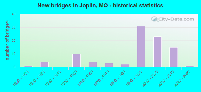
- New bridges - historical statistics
- 11920-1929
- 41930-1939
- 101950-1959
- 41960-1969
- 31970-1979
- 21980-1989
- 311990-1999
- 232000-2009
- 152010-2019
- 12020-2022
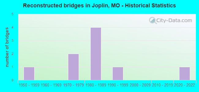
- Reconstructed bridges - Historical Statistics
- 11950-1959
- 01960-1969
- 21970-1979
- 41980-1989
- 11990-1999
- 02000-2009
- 02010-2019
- 12020-2022
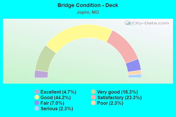
- Bridge Condition - Deck
- 4.7%Excellent
- 16.3%Very good
- 44.2%Good
- 23.3%Satisfactory
- 7.0%Fair
- 2.3%Poor
- 2.3%Serious
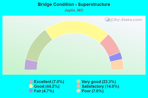
- Bridge Condition - Superstructure
- 7.0%Excellent
- 23.3%Very good
- 44.2%Good
- 14.0%Satisfactory
- 4.7%Fair
- 7.0%Poor
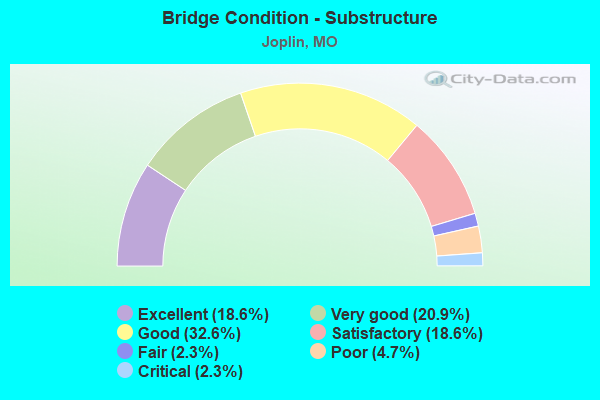
- Bridge Condition - Substructure
- 18.6%Excellent
- 20.9%Very good
- 32.6%Good
- 18.6%Satisfactory
- 2.3%Fair
- 4.7%Poor
- 2.3%Critical
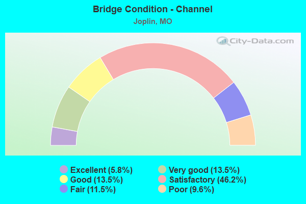
- Bridge Condition - Channel
- 5.8%Excellent
- 13.5%Very good
- 13.5%Good
- 46.2%Satisfactory
- 11.5%Fair
- 9.6%Poor
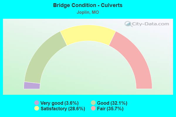
- Bridge Condition - Culverts
- 3.6%Very good
- 32.1%Good
- 28.6%Satisfactory
- 35.7%Fair
Find on map >> Show street view
Structure Number: 32855, Location: S 5 T 27 N R 32 W (Lat: 37.083683, Lng: -94.448206), Route carried "on" structure: State highway 66, Year Built: 2010, Status: Open, Structure Length: 6.19m (20.31ft), Average Daily Traffic: 12,932 (year 2021), Truck Traffic: 13%, Average Future Daily Traffic: 20,045 (year 2041), Features Intersected: TURKEY CR
Minimum Vertical Clearance: 30+ m (98+ ft), Kilometerpoint: 15.318, Lanes on structure: 5, Base Highway Network: Yes, Owner: State Highway Agency, Approaching Roadway Width: 22.6m (74.1ft), Skew: 5 degrees, Material/Design: Prestressed concrete continuous, Design/Construction: Stringer/Multi-beam, Number Of Spans In Main Unit: 4, Length of Maximum Span: 16.8m (55.1ft), Curb-To-Curb Width: 22.6m (74.1ft), Out-to-Out Width: 23.4m (76.8ft)
Condition: Deck: Good, Superstructure: Good, Substructure: Excellent, Channel: Good, Operating Rating: 73.8 metric tons, Method Used To Determine Operating Rating: Load Factor (LF), Inventory Rating: 42.3 metric tons, Method Used To Determine Inventory Rating: Load Factor (LF), Structural Evaluation: Better than present minimum criteria, Deck Geometry: Equal to present minimum criteria, Waterway Adequacy: Superior to present desirable criteria, Approach Roadway Alignment: Equal to present desirable criteria, Designated Inspection Frequency: Every 24 months, Inspection Date: August 2021, Deck Structure Type: Concrete Cast-file-Place, Wearing Surface/Protective System: Wearing Surface: Monolithic Concrete, Deck Protection: Epoxy Coated Reinforcing
Find on map >> Show street view
Structure Number: 33699, Location: S 30 T 28 N R 33 W (Lat: 37.120828, Lng: -94.582058), Route carried "on" structure: State highway P, Year Built: 2011, Status: Open, Structure Length: 4.88m (16.01ft), Average Daily Traffic: 4,251 (year 2021), Truck Traffic: 6%, Average Future Daily Traffic: 6,377 (year 2041), Design Load: HS 20, Features Intersected: TURKEY CR
Minimum Vertical Clearance: 30+ m (98+ ft), Kilometerpoint: 3.740, Lanes on structure: 2, Owner: State Highway Agency, Approaching Roadway Width: 9.1m (29.9ft), Material/Design: Prestressed concrete, Design/Construction: Box Beam or Girders - Single/Spread, Number Of Spans In Main Unit: 1, Number Of Approach Spans: 2, Length of Maximum Span: 19.8m (65.0ft), Curb-To-Curb Width: 9.1m (29.9ft), Out-to-Out Width: 9.8m (32.2ft)
Condition: Deck: Good, Superstructure: Good, Substructure: Satisfactory, Channel: Satisfactory, Operating Rating: 85.5 metric tons, Method Used To Determine Operating Rating: Load Factor (LF), Inventory Rating: 43.2 metric tons, Method Used To Determine Inventory Rating: Load Factor (LF), Structural Evaluation: Equal to present minimum criteria, Deck Geometry: Meets minimum limits, Waterway Adequacy: Superior to present desirable criteria, Approach Roadway Alignment: Equal to present desirable criteria, Designated Inspection Frequency: Every 24 months, Inspection Date: August 2020, Deck Structure Type: Concrete Cast-file-Place, Wearing Surface/Protective System: Wearing Surface: Monolithic Concrete, Deck Protection: Epoxy Coated Reinforcing
Find on map >> Show street view
Structure Number: 33881, Location: S 35 T 28 N R 33 W (Lat: 37.113667, Lng: -94.509700), Route carried "on" structure: City street , Year Built: 2012, Status: Open, Structure Length: 6.74m (22.11ft), Average Daily Traffic: 9,360 (year 2021), Truck Traffic: 5%, Average Future Daily Traffic: 14,508 (year 2041), Features Intersected: MO 43, RP MO43N TO CST, Facility Carried by Structure: E ZORA ST E
Minimum Vertical Clearance: 5.44m (17.85ft), Kilometerpoint: 0.013, Lanes on structure: 3, Lanes under structure: 5, Owner: State Highway Agency, Approaching Roadway Width: 12.6m (41.3ft), Material/Design: Steel continuous, Design/Construction: Stringer/Multi-beam, Number Of Spans In Main Unit: 2, Length of Maximum Span: 36.3m (119.1ft), Curb-To-Curb Width: 12.6m (41.3ft), Out-to-Out Width: 15.3m (50.2ft)
Condition: Deck: Good, Superstructure: Very good, Substructure: Very good, Operating Rating: 79.2 metric tons, Method Used To Determine Operating Rating: Load Factor (LF), Inventory Rating: 47.7 metric tons, Method Used To Determine Inventory Rating: Load Factor (LF), Structural Evaluation: Equal to present desirable criteria, Deck Geometry: Meets minimum limits, Underclear: High priority of corrective action, Approach Roadway Alignment: Equal to present desirable criteria, Length Of Structure Improvement: 0.78m (2.56ft), Designated Inspection Frequency: Every 24 months, Inspection Date: August 2021, Bridge Improvement Cost: $856,000, Roadway Improvement Cost: $86,000, Total Project Cost: $1,285,000 ( Estimate for 2022), Deck Structure Type: Concrete Cast-file-Place, Wearing Surface/Protective System: Wearing Surface: Monolithic Concrete, Deck Protection: Epoxy Coated Reinforcing
Find on map >> Show street view
Structure Number: 33884, Location: S 35 T 28 N R 33 W (Lat: 37.113747, Lng: -94.510667), Route carried "on" structure: County highway , Year Built: 2012, Status: Open, Structure Length: 3.90m (12.80ft), Average Daily Traffic: 6,900 (year 2021), Truck Traffic: 5%, Average Future Daily Traffic: 10,695 (year 2041), Features Intersected: KCS RR, Facility Carried by Structure: W ZORA ST E
Minimum Vertical Clearance: 7.01m (23.00ft), Kilometerpoint: 2.932, Lanes on structure: 2, Owner: State Highway Agency, Approaching Roadway Width: 12.7m (41.7ft), Skew: 2 degrees, Material/Design: Steel, Design/Construction: Stringer/Multi-beam, Number Of Spans In Main Unit: 1, Length of Maximum Span: 38.1m (125.0ft), Curb-To-Curb Width: 12.7m (41.7ft), Out-to-Out Width: 15.3m (50.2ft)
Condition: Deck: Good, Superstructure: Excellent, Substructure: Excellent, Operating Rating: 91.8 metric tons, Method Used To Determine Operating Rating: Load Factor (LF), Inventory Rating: 54.9 metric tons, Method Used To Determine Inventory Rating: Load Factor (LF), Structural Evaluation: Superior to present desirable criteria, Deck Geometry: Somewhat better than minimum adequacy, Underclear: Equal to present desirable criteria, Approach Roadway Alignment: Equal to present desirable criteria, Designated Inspection Frequency: Every 24 months, Inspection Date: August 2021, Deck Structure Type: Concrete Cast-file-Place, Wearing Surface/Protective System: Wearing Surface: Monolithic Concrete, Deck Protection: Epoxy Coated Reinforcing
Find on map >> Show street view
Structure Number: 33885, Location: S 35 T 28 N R 33 W (Lat: 37.114750, Lng: -94.508167), Route carried "on" structure: Ramp State highway , Year Built: 2012, Status: Open, Structure Length: 0.79m (2.59ft), Average Daily Traffic: 964 (year 2021), Truck Traffic: 10%, Average Future Daily Traffic: 1,494 (year 2041), Design Load: HS 20+Mod, Features Intersected: DRAIN DTCH, Facility Carried by Structure: RP CST ZORA ST TO
Minimum Vertical Clearance: 30+ m (98+ ft), Kilometerpoint: 0.127, Lanes on structure: 1, Base Highway Network: Yes, Owner: State Highway Agency, Approaching Roadway Width: 4.3m (14.1ft), Material/Design: Concrete, Design/Construction: Culvert, Number Of Spans In Main Unit: 3, Length of Maximum Span: 2.4m (7.9ft)
Condition: Channel: Satisfactory, Culverts: Good, Inventory Rating: 64.8 metric tons, Method Used To Determine Inventory Rating: Field evaluation and documented engineering judgment, Structural Evaluation: Better than present minimum criteria, Waterway Adequacy: Superior to present desirable criteria, Approach Roadway Alignment: Equal to present desirable criteria, Designated Inspection Frequency: Every 24 months, Inspection Date: January 2022
Find on map >> Show street view
Structure Number: 34469, Location: S 3 T 27 N R 33 W (Lat: 37.092108, Lng: -94.526719), Route carried "on" structure: City street , Year Built: 2011, Status: Open, Structure Length: 0.96m (3.15ft), Average Daily Traffic: 320 (year 2021), Truck Traffic: 10%, Average Future Daily Traffic: 480 (year 2041), Features Intersected: LONE ELM HOLLOW, Facility Carried by Structure: A ST
Minimum Vertical Clearance: 30+ m (98+ ft), Kilometerpoint: 0.000, Lanes on structure: 2, Owner: City or Municipal Highway Agency, Approaching Roadway Width: 9.1m (29.9ft), Skew: 9 degrees, Material/Design: Concrete, Design/Construction: Culvert, Number Of Spans In Main Unit: 2, Length of Maximum Span: 4.3m (14.1ft), Curb or Sidewalk Widths: Left: 1.5m (4.9ft), Right: 1.5m (4.9ft), Curb-To-Curb Width: 17.6m (57.7ft), Out-to-Out Width: 18.6m (61.0ft)
Condition: Channel: Satisfactory, Culverts: Good, Operating Rating: 73.8 metric tons, Method Used To Determine Operating Rating: Load Factor (LF), Inventory Rating: 44.1 metric tons, Method Used To Determine Inventory Rating: Load Factor (LF), Structural Evaluation: Better than present minimum criteria, Deck Geometry: Superior to present desirable criteria, Waterway Adequacy: Better than present minimum criteria, Approach Roadway Alignment: Equal to present desirable criteria, Designated Inspection Frequency: Every 24 months, Inspection Date: Febuary 2021, Wearing Surface/Protective System: Wearing Surface: Bituminous
Find on map >> Show street view
Structure Number: 34507, Location: S 11 T 27 N R 33 W (Lat: 37.069439, Lng: -94.501150), Route carried "on" structure: City street , Year Built: 2016, Status: Open, Structure Length: 3.78m (12.40ft), Average Daily Traffic: 18,000 (year 2021), Truck Traffic: 5%, Average Future Daily Traffic: 27,000 (year 2041), Design Load: HS 20, Features Intersected: KCS RR, Facility Carried by Structure: 20TH ST
Minimum Vertical Clearance: 30+ m (98+ ft), Kilometerpoint: 0.000, Lanes on structure: 4, Owner: County Highway Agency, Approaching Roadway Width: 14.6m (47.9ft), Material/Design: Steel, Design/Construction: Stringer/Multi-beam, Number Of Spans In Main Unit: 1, Length of Maximum Span: 36.6m (120.1ft), Curb or Sidewalk Widths: Left: 2.6m (8.5ft), Right: 2.6m (8.5ft), Curb-To-Curb Width: 19.8m (65.0ft), Out-to-Out Width: 20.5m (67.3ft)
Condition: Deck: Good, Superstructure: Good, Substructure: Excellent, Operating Rating: 81.9 metric tons, Method Used To Determine Operating Rating: Load Factor (LF), Inventory Rating: 48.6 metric tons, Method Used To Determine Inventory Rating: Load Factor (LF), Structural Evaluation: Better than present minimum criteria, Deck Geometry: Better than present minimum criteria, Underclear: Superior to present desirable criteria, Approach Roadway Alignment: Equal to present desirable criteria, Designated Inspection Frequency: Every 24 months, Inspection Date: Febuary 2021, Deck Structure Type: Concrete Cast-file-Place, Wearing Surface/Protective System: Wearing Surface: Integral Concrete, Deck Protection: Epoxy Coated Reinforcing
Find on map >> Show street view
Structure Number: 35634, Location: S 3 T 27 N R 33 W (Lat: 37.094369, Lng: -94.525764), Route carried "on" structure: City street , Year Built: 2016, Status: Open, Structure Length: 1.80m (5.91ft), Average Daily Traffic: 1,000 (year 2021), Truck Traffic: 10%, Average Future Daily Traffic: 1,500 (year 2041), Design Load: HS 20, Features Intersected: LONE ELM HOLLOW, Facility Carried by Structure: C ST
Minimum Vertical Clearance: 30+ m (98+ ft), Kilometerpoint: 0.161, Lanes on structure: 2, Owner: City or Municipal Highway Agency, Approaching Roadway Width: 9.1m (29.9ft), Skew: 4 degrees, Material/Design: Concrete, Design/Construction: Culvert, Number Of Spans In Main Unit: 3, Length of Maximum Span: 4.3m (14.1ft), Curb or Sidewalk Widths: Left: 2.6m (8.5ft), Right: 2.4m (7.9ft), Curb-To-Curb Width: 9.1m (29.9ft), Out-to-Out Width: 15.6m (51.2ft)
Condition: Channel: Satisfactory, Culverts: Satisfactory, Operating Rating: 54.0 metric tons, Method Used To Determine Operating Rating: Load Factor (LF), Inventory Rating: 32.4 metric tons, Method Used To Determine Inventory Rating: Load Factor (LF), Structural Evaluation: Equal to present minimum criteria, Deck Geometry: Equal to present minimum criteria, Waterway Adequacy: Equal to present desirable criteria, Approach Roadway Alignment: Equal to present desirable criteria, Designated Inspection Frequency: Every 24 months, Inspection Date: Febuary 2021, Deck Structure Type: Concrete Cast-file-Place, Wearing Surface/Protective System: Wearing Surface: Bituminous
Find on map >> Show street view
Structure Number: 35664, Location: S 23 T 27 N R 33 W (Lat: 37.045556, Lng: -94.496714), Route carried "on" structure: City street , Year Built: 2018, Status: Open, Structure Length: 4.68m (15.35ft), Average Daily Traffic: 4,991 (year 2021), Truck Traffic: 10%, Average Future Daily Traffic: 9,982 (year 2041), Features Intersected: IS 44, IS 44, Facility Carried by Structure: CONNECTICUT AVE S
Minimum Vertical Clearance: 30+ m (98+ ft), Kilometerpoint: 3.700, Lanes on structure: 2, Lanes under structure: 4, Owner: State Highway Agency, Approaching Roadway Width: 6.7m (22.0ft), Skew: 1 degrees, Material/Design: Prestressed concrete, Design/Construction: Stringer/Multi-beam, Number Of Spans In Main Unit: 2, Length of Maximum Span: 22.9m (75.1ft), Curb or Sidewalk Widths: Left: 2.4m (7.9ft), Right: 0.0m, Curb-To-Curb Width: 7.9m (25.9ft), Out-to-Out Width: 21.5m (70.5ft)
Condition: Deck: Very good, Superstructure: Very good, Substructure: Excellent, Operating Rating: 84.6 metric tons, Method Used To Determine Operating Rating: Load Factor (LF), Inventory Rating: 39.6 metric tons, Method Used To Determine Inventory Rating: Load Factor (LF), Structural Evaluation: Equal to present desirable criteria, Deck Geometry: High priority of corrective action, Underclear: Superior to present desirable criteria, Approach Roadway Alignment: Equal to present desirable criteria, Designated Inspection Frequency: Every 24 months, Inspection Date: September 2021, Deck Structure Type: Concrete Cast-file-Place, Wearing Surface/Protective System: Wearing Surface: Monolithic Concrete, Deck Protection: Epoxy Coated Reinforcing
Find on map >> Show street view
Structure Number: 35877, Location: S 27 T 27 N R 33 W (Lat: 37.032222, Lng: -94.525000), Route carried "on" structure: County highway 220, Year Built: 2019, Status: Open, Structure Length: 13.52m (44.36ft), Average Daily Traffic: 800 (year 2021), Truck Traffic: 10%, Average Future Daily Traffic: 1,320 (year 2041), Design Load: HS 20, Features Intersected: SHOAL CR, Facility Carried by Structure: JACKSON AVE
Minimum Vertical Clearance: 30+ m (98+ ft), Kilometerpoint: 1.770, Lanes on structure: 2, Owner: City or Municipal Highway Agency, Approaching Roadway Width: 7.9m (25.9ft), Material/Design: Prestressed concrete continuous, Design/Construction: Tee Beam, Number Of Spans In Main Unit: 5, Length of Maximum Span: 27.4m (89.9ft), Curb or Sidewalk Widths: Left: 2.4m (7.9ft), Right: 2.4m (7.9ft), Curb-To-Curb Width: 7.9m (25.9ft), Out-to-Out Width: 13.4m (44.0ft)
Condition: Deck: Good, Superstructure: Good, Substructure: Good, Channel: Very good, Operating Rating: 75.6 metric tons, Method Used To Determine Operating Rating: Load Factor (LF), Inventory Rating: 37.8 metric tons, Method Used To Determine Inventory Rating: Load Factor (LF), Structural Evaluation: Better than present minimum criteria, Deck Geometry: Somewhat better than minimum adequacy, Waterway Adequacy: Superior to present desirable criteria, Approach Roadway Alignment: Equal to present desirable criteria, Designated Inspection Frequency: Every 24 months, Inspection Date: Febuary 2021, Deck Structure Type: Concrete Cast-file-Place, Wearing Surface/Protective System: Wearing Surface: Monolithic Concrete, Deck Protection: Epoxy Coated Reinforcing
Find on map >> Show street view
Structure Number: 36001, Location: S 14 T 49 N R 1 W (Lat: 39.009728, Lng: -90.977867), Route carried "on" structure: US 61, Year Built: 2019, Status: Open, Structure Length: 30.72m (100.79ft), Average Daily Traffic: 11,188 (year 2021), Truck Traffic: 27%, Average Future Daily Traffic: 22,376 (year 2041), Features Intersected: CUIVRE RVR
Minimum Vertical Clearance: 30+ m (98+ ft), Kilometerpoint: 441.378, Lanes on structure: 2, Base Highway Network: Yes, Owner: State Highway Agency, Approaching Roadway Width: 11.6m (38.1ft), Material/Design: Prestressed concrete continuous, Design/Construction: Tee Beam, Number Of Spans In Main Unit: 8, Length of Maximum Span: 39.0m (128.0ft), Curb-To-Curb Width: 11.6m (38.1ft), Out-to-Out Width: 12.4m (40.7ft)
Condition: Deck: Very good, Superstructure: Excellent, Substructure: Very good, Channel: Very good, Operating Rating: 63.9 metric tons, Method Used To Determine Operating Rating: Load Factor (LF), Inventory Rating: 40.5 metric tons, Method Used To Determine Inventory Rating: Load Factor (LF), Structural Evaluation: Equal to present desirable criteria, Deck Geometry: Better than present minimum criteria, Waterway Adequacy: Superior to present desirable criteria, Approach Roadway Alignment: Equal to present desirable criteria, Designated Inspection Frequency: Every 24 months, Inspection Date: January 2021, Deck Structure Type: Concrete Cast-file-Place, Wearing Surface/Protective System: Wearing Surface: Monolithic Concrete, Deck Protection: Epoxy Coated Reinforcing
Find on map >> Show street view
Structure Number: 36111, Location: S 33 T 28 N R 33 W (Lat: 37.113917, Lng: -94.542917), Route carried "on" structure: County highway 626, Year Built: 2019, Status: Open, Structure Length: 8.75m (28.71ft), Average Daily Traffic: 2,500 (year 2021), Truck Traffic: 10%, Average Future Daily Traffic: 3,750 (year 2041), Design Load: HS 20, Features Intersected: TURKEY CR, Facility Carried by Structure: SHIFFERDECKER RD
Minimum Vertical Clearance: 30+ m (98+ ft), Kilometerpoint: 1.786, Lanes on structure: 3, Owner: County Highway Agency, Approaching Roadway Width: 7.9m (25.9ft), Skew: 4 degrees, Material/Design: Prestressed concrete, Design/Construction: Stringer/Multi-beam, Number Of Spans In Main Unit: 4, Length of Maximum Span: 21.9m (71.9ft), Curb-To-Curb Width: 15.4m (50.5ft), Out-to-Out Width: 16.0m (52.5ft)
Condition: Deck: Good, Superstructure: Good, Substructure: Good, Channel: Good, Operating Rating: 54.0 metric tons, Method Used To Determine Operating Rating: Load Factor (LF), Inventory Rating: 32.4 metric tons, Method Used To Determine Inventory Rating: Load Factor (LF), Structural Evaluation: Better than present minimum criteria, Deck Geometry: Equal to present minimum criteria, Waterway Adequacy: Superior to present desirable criteria, Approach Roadway Alignment: Equal to present desirable criteria, Designated Inspection Frequency: Every 24 months, Inspection Date: January 2021, Deck Structure Type: Concrete Cast-file-Place, Wearing Surface/Protective System: Wearing Surface: Monolithic Concrete, Deck Protection: Epoxy Coated Reinforcing
Find on map >> Show street view
Structure Number: 36705, Location: S 13 T 27 N R 32 W (Lat: 37.058706, Lng: -94.478239), Route carried "on" structure: Business State highway 49, Year Built: 2023, Status: Not yet open, Structure Length: 3.43m (11.25ft), Average Daily Traffic: 26,743 (year 2021), Truck Traffic: 5%, Average Future Daily Traffic: 41,452 (year 2041), Features Intersected: KCS RR
Minimum Vertical Clearance: 30+ m (98+ ft), Kilometerpoint: 23.284, Lanes on structure: 4, Base Highway Network: Yes, Owner: State Highway Agency, Approaching Roadway Width: 22.2m (72.8ft), Skew: 1 degrees, Material/Design: Prestressed concrete, Design/Construction: Tee Beam, Number Of Spans In Main Unit: 1, Length of Maximum Span: 34.3m (112.5ft), Curb-To-Curb Width: 17.7m (58.1ft), Out-to-Out Width: 22.2m (72.8ft)
Condition: Deck: Excellent, Superstructure: Excellent, Substructure: Excellent, Operating Rating: 67.5 metric tons, Method Used To Determine Operating Rating: Load and Resistance Factor (LRFR), Inventory Rating: 40.5 metric tons, Method Used To Determine Inventory Rating: Load and Resistance Factor (LRFR), Structural Evaluation: Superior to present desirable criteria, Deck Geometry: Somewhat better than minimum adequacy, Underclear: Superior to present desirable criteria, Approach Roadway Alignment: Equal to present desirable criteria, Designated Inspection Frequency: Every 24 months, Inspection Date: January 2022, Deck Structure Type: Concrete Cast-file-Place, Wearing Surface/Protective System: Wearing Surface: Monolithic Concrete, Deck Protection: Epoxy Coated Reinforcing
Find on map >> Show street view
Structure Number: 4132, Location: S 16 T 27 N R 32 W (Lat: 37.061553, Lng: -94.426797), Route carried "on" structure: State highway 249, Year Built: 1993, Year Reconstructed: 2021, Status: Open, Structure Length: 9.33m (30.61ft), Average Daily Traffic: 9,288 (year 2021), Truck Traffic: 17%, Average Future Daily Traffic: 16,718 (year 2041), Design Load: HS 20+Mod, Features Intersected: IS 44
Minimum Vertical Clearance: 30+ m (98+ ft), Kilometerpoint: 0.492, Lanes on structure: 3, Lanes under structure: 5, Base Highway Network: Yes, Owner: State Highway Agency, Approaching Roadway Width: 12.2m (40.0ft), Skew: 1 degrees, Material/Design: Steel continuous, Design/Construction: Stringer/Multi-beam, Number Of Spans In Main Unit: 2, Length of Maximum Span: 39.3m (128.9ft), Curb-To-Curb Width: 14.3m (46.9ft), Out-to-Out Width: 15.1m (49.5ft)
Condition: Deck: Satisfactory, Superstructure: Good, Substructure: Good, Operating Rating: 57.6 metric tons, Method Used To Determine Operating Rating: Load Factor (LF), Inventory Rating: 34.2 metric tons, Method Used To Determine Inventory Rating: Load Factor (LF), Structural Evaluation: Better than present minimum criteria, Deck Geometry: Meets minimum limits, Underclear: Better than present minimum criteria, Approach Roadway Alignment: Equal to present desirable criteria, Designated Inspection Frequency: Every 24 months, Inspection Date: August 2021, Deck Structure Type: Concrete Cast-file-Place, Wearing Surface/Protective System: Wearing Surface: Other, Deck Protection: Epoxy Coated Reinforcing
Find on map >> Show street view
Structure Number: 4134, Location: S 16 T 27 N R 32 W (Lat: 37.054514, Lng: -94.426458), Route carried "on" structure: State highway FF, Year Built: 1993, Year Reconstructed: 2021, Status: Open, Structure Length: 7.99m (26.21ft), Average Daily Traffic: 8,925 (year 2021), Truck Traffic: 5%, Average Future Daily Traffic: 13,834 (year 2041), Design Load: HS 20+Mod, Features Intersected: IS 49
Minimum Vertical Clearance: 30+ m (98+ ft), Kilometerpoint: 7.868, Lanes on structure: 4, Lanes under structure: 6, Base Highway Network: Yes, Owner: State Highway Agency, Approaching Roadway Width: 21.9m (71.9ft), Material/Design: Steel continuous, Design/Construction: Stringer/Multi-beam, Number Of Spans In Main Unit: 2, Length of Maximum Span: 34.4m (112.9ft), Curb or Sidewalk Widths: Left: 0.2m (0.7ft), Right: 0.2m (0.7ft), Curb-To-Curb Width: 21.6m (70.9ft), Out-to-Out Width: 22.4m (73.5ft)
Condition: Deck: Fair, Superstructure: Good, Substructure: Good, Operating Rating: 62.1 metric tons, Method Used To Determine Operating Rating: Load Factor (LF), Inventory Rating: 36.9 metric tons, Method Used To Determine Inventory Rating: Load Factor (LF), Structural Evaluation: Better than present minimum criteria, Deck Geometry: Superior to present desirable criteria, Underclear: Equal to present minimum criteria, Approach Roadway Alignment: Equal to present desirable criteria, Designated Inspection Frequency: Every 24 months, Inspection Date: August 2021, Deck Structure Type: Concrete Cast-file-Place, Wearing Surface/Protective System: Wearing Surface: Other, Deck Protection: Epoxy Coated Reinforcing
Find on map >> Show street view
Structure Number: 419, Location: S 18 T 27 N R 31 W (Lat: 37.053806, Lng: -94.368556), Route carried "on" structure: State highway FF, Year Built: 1992, Status: Open, Structure Length: 1.50m (4.92ft), Average Daily Traffic: 3,413 (year 2021), Truck Traffic: 10%, Average Future Daily Traffic: 5,120 (year 2041), Design Load: HS 20, Features Intersected: GROVE CR
Minimum Vertical Clearance: 30+ m (98+ ft), Kilometerpoint: 13.050, Lanes on structure: 2, Owner: State Highway Agency, Approaching Roadway Width: 12.2m (40.0ft), Skew: 2 degrees, Material/Design: Concrete continuous, Design/Construction: Culvert, Number Of Spans In Main Unit: 3, Length of Maximum Span: 4.6m (15.1ft)
Condition: Channel: Fair, Culverts: Satisfactory, Operating Rating: 87.3 metric tons, Method Used To Determine Operating Rating: Field evaluation and documented engineering judgment, Inventory Rating: 52.2 metric tons, Method Used To Determine Inventory Rating: Field evaluation and documented engineering judgment, Structural Evaluation: Equal to present minimum criteria, Waterway Adequacy: Equal to present desirable criteria, Approach Roadway Alignment: Equal to present desirable criteria, Designated Inspection Frequency: Every 24 months, Inspection Date: January 2022
Find on map >> Show street view
Structure Number: 4354, Location: S 17 T 27 N R 32 W (Lat: 37.055461, Lng: -94.444281), Route carried "on" structure: State highway FF, Year Built: 1996, Year Reconstructed: 2021, Status: Open, Structure Length: 13.11m (43.01ft), Average Daily Traffic: 12,940 (year 2021), Truck Traffic: 12%, Average Future Daily Traffic: 20,057 (year 2041), Design Load: HS 20, Features Intersected: IS 44
Minimum Vertical Clearance: 30+ m (98+ ft), Kilometerpoint: 6.225, Lanes on structure: 5, Lanes under structure: 4, Base Highway Network: Yes, Owner: State Highway Agency, Approaching Roadway Width: 21.9m (71.9ft), Skew: 5 degrees, Material/Design: Steel continuous, Design/Construction: Stringer/Multi-beam, Number Of Spans In Main Unit: 4, Length of Maximum Span: 38.1m (125.0ft), Curb or Sidewalk Widths: Left: 0.2m (0.7ft), Right: 0.2m (0.7ft), Curb-To-Curb Width: 21.6m (70.9ft), Out-to-Out Width: 22.4m (73.5ft)
Condition: Deck: Satisfactory, Superstructure: Good, Substructure: Good, Operating Rating: 66.6 metric tons, Method Used To Determine Operating Rating: Load Factor (LF), Inventory Rating: 39.6 metric tons, Method Used To Determine Inventory Rating: Load Factor (LF), Structural Evaluation: Better than present minimum criteria, Deck Geometry: Somewhat better than minimum adequacy, Underclear: Somewhat better than minimum adequacy, Approach Roadway Alignment: Equal to present desirable criteria, Designated Inspection Frequency: Every 24 months, Inspection Date: August 2021, Deck Structure Type: Concrete Cast-file-Place, Wearing Surface/Protective System: Wearing Surface: Epoxy Overlay, Deck Protection: Epoxy Coated Reinforcing
Find on map >> Show street view
Structure Number: 4397, Location: S 4 T 26 N R 33 W (Lat: 37.009836, Lng: -94.547961), Route carried "on" structure: State highway 43, Year Built: 1996, Status: Open, Structure Length: 13.35m (43.80ft), Average Daily Traffic: 9,708 (year 2021), Truck Traffic: 27%, Average Future Daily Traffic: 19,416 (year 2041), Design Load: HS 20, Features Intersected: IS 44
Minimum Vertical Clearance: 30+ m (98+ ft), Kilometerpoint: 94.914, Lanes on structure: 5, Lanes under structure: 4, Owner: State Highway Agency, Approaching Roadway Width: 25.0m (82.0ft), Skew: 4 degrees, Material/Design: Steel continuous, Design/Construction: Stringer/Multi-beam, Number Of Spans In Main Unit: 4, Length of Maximum Span: 39.6m (129.9ft), Curb or Sidewalk Widths: Left: 0.2m (0.7ft), Right: 0.2m (0.7ft), Curb-To-Curb Width: 25.0m (82.0ft), Out-to-Out Width: 25.8m (84.6ft)
Condition: Deck: Satisfactory, Superstructure: Good, Substructure: Very good, Operating Rating: 72.0 metric tons, Method Used To Determine Operating Rating: Load Factor (LF), Inventory Rating: 43.2 metric tons, Method Used To Determine Inventory Rating: Load Factor (LF), Structural Evaluation: Better than present minimum criteria, Deck Geometry: Superior to present desirable criteria, Underclear: Better than present minimum criteria, Approach Roadway Alignment: Equal to present desirable criteria, Designated Inspection Frequency: Every 24 months, Inspection Date: September 2021, Deck Structure Type: Concrete Cast-file-Place, Wearing Surface/Protective System: Wearing Surface: Monolithic Concrete, Deck Protection: Epoxy Coated Reinforcing
Find on map >> Show street view
Structure Number: 4427, Location: S 1 T 27 N R 33 W (Lat: 37.083947, Lng: -94.506714), Route carried "on" structure: State highway 66, Year Built: 1996, Status: Open, Structure Length: 10.15m (33.30ft), Average Daily Traffic: 14,789 (year 2021), Truck Traffic: 5%, Average Future Daily Traffic: 22,923 (year 2041), Design Load: HS 20+Mod, Features Intersected: BNSF RR, KCS RR, JOPLIN
Minimum Vertical Clearance: 30+ m (98+ ft), Kilometerpoint: 10.086, Lanes on structure: 4, Base Highway Network: Yes, Owner: State Highway Agency, Approaching Roadway Width: 18.3m (60.0ft), Material/Design: Prestressed concrete continuous, Design/Construction: Stringer/Multi-beam, Number Of Spans In Main Unit: 6, Length of Maximum Span: 17.7m (58.1ft), Curb or Sidewalk Widths: Left: 1.2m (3.9ft), Right: 0.0m, Curb-To-Curb Width: 17.1m (56.1ft), Out-to-Out Width: 19.3m (63.3ft)
Condition: Deck: Good, Superstructure: Good, Substructure: Good, Channel: Excellent, Operating Rating: 81.0 metric tons, Method Used To Determine Operating Rating: Load Factor (LF), Inventory Rating: 48.6 metric tons, Method Used To Determine Inventory Rating: Load Factor (LF), Structural Evaluation: Better than present minimum criteria, Deck Geometry: Somewhat better than minimum adequacy, Underclear: Meets minimum limits, Waterway Adequacy: Superior to present desirable criteria, Approach Roadway Alignment: Equal to present desirable criteria, Designated Inspection Frequency: Every 24 months, Inspection Date: August 2021, Deck Structure Type: Concrete Cast-file-Place, Wearing Surface/Protective System: Wearing Surface: Monolithic Concrete, Deck Protection: Epoxy Coated Reinforcing
Find on map >> Show street view
Structure Number: 481, Location: S 1 T 27 N R 34 W (Lat: 37.085469, Lng: -94.589994), Route carried "on" structure: State highway 66, Year Built: 1960, Year Reconstructed: 1981, Status: Open, Structure Length: 1.15m (3.77ft), Average Daily Traffic: 14,187 (year 2021), Truck Traffic: 11%, Average Future Daily Traffic: 21,990 (year 2041), Design Load: H 20, Features Intersected: SHORT CR
Minimum Vertical Clearance: 30+ m (98+ ft), Kilometerpoint: 2.720, Lanes on structure: 4, Base Highway Network: Yes, Owner: State Highway Agency, Approaching Roadway Width: 39.0m (128.0ft), Skew: 20 degrees, Material/Design: Concrete continuous, Design/Construction: Culvert, Number Of Spans In Main Unit: 3, Length of Maximum Span: 3.7m (12.1ft)
Condition: Channel: Satisfactory, Culverts: Satisfactory, Inventory Rating: 72.9 metric tons, Method Used To Determine Inventory Rating: Load Factor (LF), Structural Evaluation: Equal to present minimum criteria, Waterway Adequacy: Equal to present desirable criteria, Approach Roadway Alignment: Equal to present desirable criteria, Designated Inspection Frequency: Every 24 months, Inspection Date: January 2022
Find on map >> Show street view
Structure Number: 5801, Location: S 2 T 27 N R 33 W (Lat: 37.099289, Lng: -94.512789), Route carried "on" structure: State highway 43, Year Built: 1934, Year Reconstructed: 1987, Status: Open, Structure Length: 11.28m (37.01ft), Average Daily Traffic: 13,425 (year 2021), Truck Traffic: 6%, Average Future Daily Traffic: 20,809 (year 2041), Design Load: H 15, Features Intersected: KCS RR, JOPLIN CR
Minimum Vertical Clearance: 30+ m (98+ ft), Kilometerpoint: 83.704, Lanes on structure: 4, Base Highway Network: Yes, Owner: State Highway Agency, Approaching Roadway Width: 17.1m (56.1ft), Material/Design: Concrete, Design/Construction: Tee Beam, Number Of Spans In Main Unit: 9, Length of Maximum Span: 13.2m (43.3ft), Curb-To-Curb Width: 12.8m (42.0ft), Out-to-Out Width: 16.8m (55.1ft)
Condition: Deck: Satisfactory, Superstructure: Fair, Substructure: Poor, Channel: Satisfactory, Operating Rating: 70.2 metric tons, Method Used To Determine Operating Rating: Load Factor (LF), Inventory Rating: 42.3 metric tons, Method Used To Determine Inventory Rating: Load Factor (LF), Structural Evaluation: Meets minimum limits, Deck Geometry: High priority of replacement, Underclear: Meets minimum limits, Waterway Adequacy: Equal to present desirable criteria, Approach Roadway Alignment: Equal to present minimum criteria, Length Of Structure Improvement: 1.22m (4.00ft), Designated Inspection Frequency: Every 24 months, Inspection Date: August 2021, Bridge Improvement Cost: $2,544,000, Roadway Improvement Cost: $254,000, Total Project Cost: $3,816,000 ( Estimate for 2022), Deck Structure Type: Concrete Cast-file-Place, Wearing Surface/Protective System: Wearing Surface: Low Slump Concrete
Find on map >> Show street view
Structure Number: 6082, Location: S 2 T 27 N R 33 W (Lat: 37.083922, Lng: -94.501706), Route carried "on" structure: State highway 66, Year Built: 1953, Year Reconstructed: 2020, Status: Open, Structure Length: 0.85m (2.79ft), Average Daily Traffic: 18,084 (year 2021), Truck Traffic: 5%, Average Future Daily Traffic: 28,030 (year 2041), Design Load: H 20, Features Intersected: E FK JOPLIN CR
Minimum Vertical Clearance: 30+ m (98+ ft), Kilometerpoint: 10.578, Lanes on structure: 4, Base Highway Network: Yes, Owner: State Highway Agency, Approaching Roadway Width: 23.2m (76.1ft), Skew: 2 degrees, Material/Design: Concrete continuous, Design/Construction: Culvert, Number Of Spans In Main Unit: 2, Length of Maximum Span: 3.7m (12.1ft)
Condition: Channel: Good, Culverts: Fair, Operating Rating: 80.1 metric tons, Method Used To Determine Operating Rating: Load Factor (LF), Inventory Rating: 47.7 metric tons, Method Used To Determine Inventory Rating: Load Factor (LF), Structural Evaluation: Somewhat better than minimum adequacy, Waterway Adequacy: Equal to present minimum criteria, Approach Roadway Alignment: Equal to present desirable criteria, Designated Inspection Frequency: Every 24 months, Inspection Date: January 2022
Find on map >> Show street view
Structure Number: 6539, Location: S 1 T 27 N R 32 W (Lat: 37.097219, Lng: -94.476703), Route carried "on" structure: Business State highway 49, Year Built: 1957, Year Reconstructed: 1987, Status: Open, Structure Length: 4.36m (14.30ft), Average Daily Traffic: 20,946 (year 2021), Truck Traffic: 5%, Average Future Daily Traffic: 32,466 (year 2041), Design Load: H 20, Features Intersected: TURKEY CR
Minimum Vertical Clearance: 30+ m (98+ ft), Kilometerpoint: 19.039, Lanes on structure: 6, Base Highway Network: Yes, Owner: State Highway Agency, Approaching Roadway Width: 26.2m (86.0ft), Skew: 4 degrees, Material/Design: Concrete, Design/Construction: Tee Beam, Number Of Spans In Main Unit: 3, Length of Maximum Span: 14.5m (47.6ft), Curb or Sidewalk Widths: Left: 0.2m (0.7ft), Right: 0.2m (0.7ft), Curb-To-Curb Width: 21.3m (69.9ft), Out-to-Out Width: 22.1m (72.5ft)
Condition: Deck: Satisfactory, Superstructure: Poor, Substructure: Poor, Channel: Fair, Operating Rating: 54.0 metric tons, Method Used To Determine Operating Rating: Load Factor (LF), Inventory Rating: 32.4 metric tons, Method Used To Determine Inventory Rating: Load Factor (LF), Structural Evaluation: Meets minimum limits, Deck Geometry: High priority of replacement, Waterway Adequacy: Equal to present minimum criteria, Approach Roadway Alignment: Equal to present desirable criteria, Length Of Structure Improvement: 0.53m (1.74ft), Designated Inspection Frequency: Every 24 months, Inspection Date: August 2021, Bridge Improvement Cost: $1,482,000, Roadway Improvement Cost: $148,000, Total Project Cost: $2,224,000 ( Estimate for 2022), Deck Structure Type: Concrete Cast-file-Place, Wearing Surface/Protective System: Wearing Surface: Bituminous, Membrane: Built-up
Find on map >> Show street view
Structure Number: 654, Location: S 13 T 27 N R 32 W (Lat: 37.058706, Lng: -94.478239), Route carried "on" structure: Business State highway 49, Year Built: 1957, Year Reconstructed: 1976, Status: Open, Structure Length: 4.21m (13.81ft), Average Daily Traffic: 26,743 (year 2021), Truck Traffic: 5%, Average Future Daily Traffic: 41,452 (year 2041), Design Load: H 20, Features Intersected: KCS RR
Minimum Vertical Clearance: 30+ m (98+ ft), Kilometerpoint: 23.274, Lanes on structure: 4, Base Highway Network: Yes, Owner: State Highway Agency, Approaching Roadway Width: 18.3m (60.0ft), Skew: 1 degrees, Material/Design: Steel continuous, Design/Construction: Stringer/Multi-beam, Number Of Spans In Main Unit: 3, Length of Maximum Span: 15.2m (49.9ft), Curb or Sidewalk Widths: Left: 0.2m (0.7ft), Right: 0.2m (0.7ft), Curb-To-Curb Width: 16.7m (54.8ft), Out-to-Out Width: 17.6m (57.7ft)
Condition: Deck: Serious, Superstructure: Poor, Substructure: Satisfactory, Operating Rating: 40.5 metric tons, Method Used To Determine Operating Rating: Load Factor (LF), Inventory Rating: 24.3 metric tons, Method Used To Determine Inventory Rating: Load Factor (LF), Structural Evaluation: Meets minimum limits, Deck Geometry: Somewhat better than minimum adequacy, Underclear: Equal to present minimum criteria, Approach Roadway Alignment: Equal to present desirable criteria, Length Of Structure Improvement: 0.52m (1.71ft), Designated Inspection Frequency: Every 24 months, Inspection Date: August 2021, Bridge Improvement Cost: $1,087,000, Roadway Improvement Cost: $109,000, Total Project Cost: $1,631,000 ( Estimate for 2022), Deck Structure Type: Concrete Cast-file-Place, Wearing Surface/Protective System: Wearing Surface: Bituminous, Membrane: Built-up
Find on map >> Show street view
Structure Number: 6551, Location: S 11 T 26 N R 34 W (Lat: 36.998194, Lng: -94.612397), Route carried "on" structure: Interstate 44, Year Built: 1956, Year Reconstructed: 1994, Status: Open, Structure Length: 4.30m (14.11ft), Average Daily Traffic: 15,963 (year 2021), Truck Traffic: 32%, Average Future Daily Traffic: 29,532 (year 2041), Design Load: HS 20, Features Intersected: US 166
Minimum Vertical Clearance: 30+ m (98+ ft), Kilometerpoint: 471.238, Lanes on structure: 2, Lanes under structure: 2, Base Highway Network: Yes, Owner: State Highway Agency, Approaching Roadway Width: 12.2m (40.0ft), Skew: 1 degrees, Material/Design: Steel continuous, Design/Construction: Stringer/Multi-beam, Number Of Spans In Main Unit: 3, Length of Maximum Span: 15.8m (51.8ft), Curb or Sidewalk Widths: Left: 0.2m (0.7ft), Right: 0.2m (0.7ft), Curb-To-Curb Width: 11.2m (36.7ft), Out-to-Out Width: 12.1m (39.7ft)
Condition: Deck: Satisfactory, Superstructure: Good, Substructure: Good, Operating Rating: 52.2 metric tons, Method Used To Determine Operating Rating: Load Factor (LF), Inventory Rating: 30.6 metric tons, Method Used To Determine Inventory Rating: Load Factor (LF), Structural Evaluation: Better than present minimum criteria, Deck Geometry: Somewhat better than minimum adequacy, Underclear: Equal to present minimum criteria, Approach Roadway Alignment: Equal to present desirable criteria, Designated Inspection Frequency: Every 24 months, Inspection Date: September 2021, Deck Structure Type: Concrete Cast-file-Place, Wearing Surface/Protective System: Wearing Surface: Low Slump Concrete
Find on map >> Show street view
Structure Number: 6558, Location: S 31 T 28 N R 32 W (Lat: 37.109236, Lng: -94.476208), Route carried "on" structure: Business State highway 49, Year Built: 1935, Year Reconstructed: 1957, Status: Open, Structure Length: 0.89m (2.92ft), Average Daily Traffic: 24,117 (year 2021), Truck Traffic: 5%, Average Future Daily Traffic: 37,381 (year 2041), Design Load: H 20, Features Intersected: BAKER BR
Minimum Vertical Clearance: 30+ m (98+ ft), Kilometerpoint: 17.717, Lanes on structure: 5, Base Highway Network: Yes, Owner: State Highway Agency, Approaching Roadway Width: 13.4m (44.0ft), Skew: 4 degrees, Material/Design: Concrete continuous, Design/Construction: Culvert, Number Of Spans In Main Unit: 2, Length of Maximum Span: 3.0m (9.8ft)
Condition: Channel: Satisfactory, Culverts: Fair, Operating Rating: 69.3 metric tons, Method Used To Determine Operating Rating: Load Factor (LF), Inventory Rating: 41.4 metric tons, Method Used To Determine Inventory Rating: Load Factor (LF), Structural Evaluation: Somewhat better than minimum adequacy, Waterway Adequacy: Equal to present minimum criteria, Approach Roadway Alignment: Equal to present desirable criteria, Designated Inspection Frequency: Every 24 months, Inspection Date: January 2022
Find on map >> Show street view
Structure Number: 6884, Location: S 14 T 27 N R 32 W (Lat: 37.054000, Lng: -94.390278), Route carried "on" structure: State highway FF, Year Built: 1956, Status: Open, Structure Length: 0.75m (2.46ft), Average Daily Traffic: 3,413 (year 2021), Truck Traffic: 10%, Average Future Daily Traffic: 5,120 (year 2041), Design Load: H 10, Features Intersected: TURKEY CR
Minimum Vertical Clearance: 30+ m (98+ ft), Kilometerpoint: 11.130, Lanes on structure: 2, Owner: State Highway Agency, Approaching Roadway Width: 7.3m (24.0ft), Material/Design: Concrete continuous, Design/Construction: Culvert, Number Of Spans In Main Unit: 2, Length of Maximum Span: 3.7m (12.1ft), Curb-To-Curb Width: 7.3m (24.0ft), Out-to-Out Width: 7.9m (25.9ft)
Condition: Channel: Poor, Culverts: Fair, Operating Rating: 36.0 metric tons, Method Used To Determine Operating Rating: Load Factor (LF), Inventory Rating: 21.6 metric tons, Method Used To Determine Inventory Rating: Load Factor (LF), Structural Evaluation: Somewhat better than minimum adequacy, Deck Geometry: High priority of replacement, Waterway Adequacy: Equal to present desirable criteria, Approach Roadway Alignment: Equal to present desirable criteria, Length Of Structure Improvement: 0.14m (0.46ft), Designated Inspection Frequency: Every 24 months, Inspection Date: January 2022, Bridge Improvement Cost: $250,000, Roadway Improvement Cost: $25,000, Total Project Cost: $375,000 ( Estimate for 2022)
Find on map >> Show street view
Structure Number: 7804, Location: S 27 T 28 N R 32 W (Lat: 37.112008, Lng: -94.413133), Route carried "on" structure: State highway AA, Year Built: 1954, Year Reconstructed: 1990, Status: Open, Structure Length: 0.62m (2.03ft), Average Daily Traffic: 532 (year 2021), Truck Traffic: 15%, Average Future Daily Traffic: 798 (year 2041), Design Load: H 10, Features Intersected: BEN'S BR
Minimum Vertical Clearance: 30+ m (98+ ft), Kilometerpoint: 3.885, Lanes on structure: 2, Owner: State Highway Agency, Approaching Roadway Width: 7.3m (24.0ft), Material/Design: Concrete continuous, Design/Construction: Culvert, Number Of Spans In Main Unit: 2, Length of Maximum Span: 3.0m (9.8ft), Curb-To-Curb Width: 7.3m (24.0ft), Out-to-Out Width: 7.9m (25.9ft)
Condition: Channel: Poor, Culverts: Satisfactory, Operating Rating: 39.6 metric tons, Method Used To Determine Operating Rating: Load Factor (LF), Inventory Rating: 23.4 metric tons, Method Used To Determine Inventory Rating: Load Factor (LF), Structural Evaluation: Equal to present minimum criteria, Deck Geometry: Meets minimum limits, Waterway Adequacy: Equal to present minimum criteria, Approach Roadway Alignment: Equal to present desirable criteria, Designated Inspection Frequency: Every 24 months, Inspection Date: January 2022
Find on map >> Show street view
Structure Number: 11826, Location: S 16 T 27 N R 32 W (Lat: 37.061439, Lng: -94.427114), Route carried "under" structure: Interstate 44, Year Built: 1999, Structure Length: 0. m, Average Daily Traffic: 23,439 (year 2021), Truck Traffic: 28%, Features Intersected: IS 44, Facility Carried by Structure: MO 249 S
Minimum Vertical Clearance: 5.03m (16.50ft), Kilometerpoint: 19.087, Lanes on structure: 2, Lanes under structure: 3, Material/Design: Steel continuous, Design/Construction: Stringer/Multi-beam, Length of Maximum Span: 39.3m (128.9ft)
Find on map >> Show street view
Structure Number: 11826, Location: S 16 T 27 N R 32 W (Lat: 37.061439, Lng: -94.427114), Route carried "under" structure: Interstate 44, Year Built: 1999, Structure Length: 0. m, Average Daily Traffic: 17,954 (year 2021), Truck Traffic: 32%, Features Intersected: IS 44, Facility Carried by Structure: MO 249 S
Minimum Vertical Clearance: 5.08m (16.67ft), Kilometerpoint: 452.711, Lanes on structure: 2, Lanes under structure: 2, Material/Design: Steel continuous, Design/Construction: Stringer/Multi-beam, Length of Maximum Span: 39.3m (128.9ft)
Find on map >> Show street view
Structure Number: 11875, Location: S 9 T 27 N R 32 W (Lat: 37.068939, Lng: -94.427506), Route carried "under" structure: County highway , Year Built: 2005, Structure Length: 0. m, Average Daily Traffic: 1,998 (year 2021), Truck Traffic: 16%, Features Intersected: CRD 20TH ST, Facility Carried by Structure: MO 249 S
Minimum Vertical Clearance: 4.73m (15.52ft), Kilometerpoint: 2.152, Lanes on structure: 2, Lanes under structure: 2, Material/Design: Prestressed concrete continuous, Design/Construction: Stringer/Multi-beam, Length of Maximum Span: 16.6m (54.5ft)
Find on map >> Show street view
Structure Number: 11922, Location: S 16 T 27 N R 32 W (Lat: 37.064422, Lng: -94.427331), Route carried "under" structure: Interstate 49, Year Built: 1999, Structure Length: 0. m, Average Daily Traffic: 2,996 (year 2021), Truck Traffic: 49%, Features Intersected: IS 49
Minimum Vertical Clearance: 5.21m (17.09ft), Kilometerpoint: 231.448, Lanes on structure: 2, Lanes under structure: 1, Material/Design: Prestressed concrete continuous, Design/Construction: Stringer/Multi-beam, Length of Maximum Span: 18.9m (62.0ft)
Find on map >> Show street view
Structure Number: 11923, Location: S 16 T 27 N R 32 W (Lat: 37.064494, Lng: -94.427022), Route carried "under" structure: Interstate 49, Year Built: 1999, Structure Length: 0. m, Average Daily Traffic: 2,996 (year 2021), Truck Traffic: 49%, Features Intersected: IS 49
Minimum Vertical Clearance: 5.21m (17.09ft), Kilometerpoint: 231.421, Lanes on structure: 2, Lanes under structure: 1, Material/Design: Prestressed concrete continuous, Design/Construction: Stringer/Multi-beam, Length of Maximum Span: 18.9m (62.0ft)
Find on map >> Show street view
Structure Number: 3104, Location: S 9 T 27 N R 32 W (Lat: 37.068956, Lng: -94.427214), Route carried "under" structure: County highway , Year Built: 1999, Structure Length: 0. m, Average Daily Traffic: 1,998 (year 2021), Truck Traffic: 16%, Features Intersected: CRD 20TH ST, Facility Carried by Structure: MO 249 N
Minimum Vertical Clearance: 4.50m (14.76ft), Kilometerpoint: 2.177, Lanes on structure: 2, Lanes under structure: 2, Material/Design: Prestressed concrete continuous, Design/Construction: Stringer/Multi-beam, Length of Maximum Span: 16.6m (54.5ft)
Find on map >> Show street view
Structure Number: 31618, Location: S 28 T 28 N R 32 W (Lat: 37.112086, Lng: -94.433819), Route carried "under" structure: State highway VV, Year Built: 2006, Structure Length: 0. m, Average Daily Traffic: 2,121 (year 2021), Truck Traffic: 14%, Features Intersected: RT VV, Facility Carried by Structure: MO 249 N
Minimum Vertical Clearance: 5.77m (18.93ft), Kilometerpoint: 0.113, Lanes on structure: 2, Lanes under structure: 2, Material/Design: Prestressed concrete continuous, Design/Construction: Tee Beam, Length of Maximum Span: 38.4m (126.0ft)
Find on map >> Show street view
Structure Number: 31624, Location: S 28 T 28 N R 32 W (Lat: 37.112064, Lng: -94.434156), Route carried "under" structure: State highway VV, Year Built: 2006, Structure Length: 0. m, Average Daily Traffic: 2,121 (year 2021), Truck Traffic: 14%, Features Intersected: RT VV, Facility Carried by Structure: MO 249 S
Minimum Vertical Clearance: 5.77m (18.93ft), Kilometerpoint: 0.082, Lanes on structure: 2, Lanes under structure: 2, Material/Design: Prestressed concrete continuous, Design/Construction: Tee Beam, Length of Maximum Span: 38.4m (126.0ft)
Find on map >> Show street view
Structure Number: 31626, Location: S 4 T 27 N R 32 W (Lat: 37.097625, Lng: -94.425683), Route carried "under" structure: City street , Year Built: 2006, Structure Length: 0. m, Average Daily Traffic: 3,214 (year 2021), Truck Traffic: 20%, Features Intersected: CST NEWMAN RD, Facility Carried by Structure: MO 249 N
Minimum Vertical Clearance: 5.00m (16.40ft), Kilometerpoint: 0.467, Lanes on structure: 2, Lanes under structure: 2, Material/Design: Steel continuous, Design/Construction: Stringer/Multi-beam, Length of Maximum Span: 26.8m (87.9ft)
Find on map >> Show street view
Structure Number: 31627, Location: S 4 T 27 N R 32 W (Lat: 37.097633, Lng: -94.426006), Route carried "under" structure: City street , Year Built: 2006, Structure Length: 0. m, Average Daily Traffic: 3,214 (year 2021), Truck Traffic: 20%, Features Intersected: CST NEWMAN RD, Facility Carried by Structure: MO 249 S
Minimum Vertical Clearance: 5.00m (16.40ft), Kilometerpoint: 0.467, Lanes on structure: 2, Lanes under structure: 2, Material/Design: Steel continuous, Design/Construction: Stringer/Multi-beam, Length of Maximum Span: 26.8m (87.9ft)
Find on map >> Show street view
Structure Number: 33881, Location: S 35 T 28 N R 33 W (Lat: 37.113667, Lng: -94.509700), Route carried "under" structure: State highway 43, Year Built: 2012, Structure Length: 0. m, Average Daily Traffic: 8,860 (year 2021), Truck Traffic: 5%, Features Intersected: MO 43, Facility Carried by Structure: E ZORA ST E
Minimum Vertical Clearance: 6.10m (20.01ft), Kilometerpoint: 82.127, Lanes on structure: 3, Lanes under structure: 2, Material/Design: Steel continuous, Design/Construction: Stringer/Multi-beam, Length of Maximum Span: 36.3m (119.1ft)
Find on map >> Show street view
Structure Number: 33881, Location: S 35 T 28 N R 33 W (Lat: 37.113667, Lng: -94.509700), Route carried "under" structure: State highway 43, Year Built: 2012, Structure Length: 0. m, Average Daily Traffic: 5,467 (year 2021), Truck Traffic: 5%, Features Intersected: MO 43, Facility Carried by Structure: E ZORA ST E
Minimum Vertical Clearance: 5.44m (17.85ft), Kilometerpoint: 76.201, Lanes on structure: 3, Lanes under structure: 2, Material/Design: Steel continuous, Design/Construction: Stringer/Multi-beam, Length of Maximum Span: 36.3m (119.1ft)
Find on map >> Show street view
Structure Number: 33881, Location: S 35 T 28 N R 33 W (Lat: 37.113667, Lng: -94.509700), Route carried "under" structure: Ramp State highway , Year Built: 2012, Structure Length: 0. m, Average Daily Traffic: 706 (year 2021), Truck Traffic: 5%, Features Intersected: RP MO43N TO CST ZORA ST, Facility Carried by Structure: E ZORA ST E
Minimum Vertical Clearance: 5.49m (18.01ft), Kilometerpoint: 0.177, Lanes on structure: 3, Lanes under structure: 1, Material/Design: Steel continuous, Design/Construction: Stringer/Multi-beam, Length of Maximum Span: 36.3m (119.1ft)
Find on map >> Show street view
Structure Number: 4132, Location: S 16 T 27 N R 32 W (Lat: 37.061553, Lng: -94.426797), Route carried "under" structure: Interstate 44, Year Built: 1993, Structure Length: 0. m, Average Daily Traffic: 17,954 (year 2021), Truck Traffic: 32%, Features Intersected: IS 44, Facility Carried by Structure: MO 249 N
Minimum Vertical Clearance: 5.21m (17.09ft), Kilometerpoint: 452.680, Lanes on structure: 3, Lanes under structure: 2, Material/Design: Steel continuous, Design/Construction: Stringer/Multi-beam, Length of Maximum Span: 39.3m (128.9ft)
Find on map >> Show street view
Structure Number: 4132, Location: S 16 T 27 N R 32 W (Lat: 37.061553, Lng: -94.426797), Route carried "under" structure: Interstate 44, Year Built: 1993, Structure Length: 0. m, Average Daily Traffic: 19,326 (year 2021), Truck Traffic: 28%, Features Intersected: IS 44, Facility Carried by Structure: MO 249 N
Minimum Vertical Clearance: 5.23m (17.16ft), Kilometerpoint: 19.119, Lanes on structure: 3, Lanes under structure: 3, Material/Design: Steel continuous, Design/Construction: Stringer/Multi-beam, Length of Maximum Span: 39.3m (128.9ft)
Find on map >> Show street view
Structure Number: 4134, Location: S 16 T 27 N R 32 W (Lat: 37.054514, Lng: -94.426458), Route carried "under" structure: Interstate 49, Year Built: 1993, Structure Length: 0. m, Average Daily Traffic: 10,578 (year 2021), Truck Traffic: 31%, Features Intersected: IS 49, Facility Carried by Structure: RT FF E
Minimum Vertical Clearance: 5.03m (16.50ft), Kilometerpoint: 63.331, Lanes on structure: 4, Lanes under structure: 3, Material/Design: Steel continuous, Design/Construction: Stringer/Multi-beam, Length of Maximum Span: 34.4m (112.9ft)
Find on map >> Show street view
Structure Number: 4134, Location: S 16 T 27 N R 32 W (Lat: 37.054514, Lng: -94.426458), Route carried "under" structure: Interstate 49, Year Built: 1993, Structure Length: 0. m, Average Daily Traffic: 11,646 (year 2021), Truck Traffic: 49%, Features Intersected: IS 49, Facility Carried by Structure: RT FF E
Minimum Vertical Clearance: 5.08m (16.67ft), Kilometerpoint: 232.789, Lanes on structure: 4, Lanes under structure: 3, Material/Design: Steel continuous, Design/Construction: Stringer/Multi-beam, Length of Maximum Span: 34.4m (112.9ft)
Find on map >> Show street view
Structure Number: 4354, Location: S 17 T 27 N R 32 W (Lat: 37.055461, Lng: -94.444281), Route carried "under" structure: Interstate 44, Year Built: 1996, Structure Length: 0. m, Average Daily Traffic: 23,439 (year 2021), Truck Traffic: 28%, Features Intersected: IS 44, Facility Carried by Structure: RT FF E
Minimum Vertical Clearance: 5.00m (16.40ft), Kilometerpoint: 17.418, Lanes on structure: 5, Lanes under structure: 2, Material/Design: Steel continuous, Design/Construction: Stringer/Multi-beam, Length of Maximum Span: 38.1m (125.0ft)
Find on map >> Show street view
Structure Number: 4354, Location: S 17 T 27 N R 32 W (Lat: 37.055461, Lng: -94.444281), Route carried "under" structure: Interstate 44, Year Built: 1996, Structure Length: 0. m, Average Daily Traffic: 19,788 (year 2021), Truck Traffic: 32%, Features Intersected: IS 44, Facility Carried by Structure: RT FF E
Minimum Vertical Clearance: 5.39m (17.68ft), Kilometerpoint: 454.428, Lanes on structure: 5, Lanes under structure: 2, Material/Design: Steel continuous, Design/Construction: Stringer/Multi-beam, Length of Maximum Span: 38.1m (125.0ft)
Find on map >> Show street view
Structure Number: 4397, Location: S 4 T 26 N R 33 W (Lat: 37.009836, Lng: -94.547961), Route carried "under" structure: Interstate 44, Year Built: 1996, Structure Length: 0. m, Average Daily Traffic: 16,074 (year 2021), Truck Traffic: 28%, Features Intersected: IS 44, Facility Carried by Structure: MO 43 S
Minimum Vertical Clearance: 5.11m (16.77ft), Kilometerpoint: 6.416, Lanes on structure: 5, Lanes under structure: 2, Material/Design: Steel continuous, Design/Construction: Stringer/Multi-beam, Length of Maximum Span: 39.6m (129.9ft)
Find on map >> Show street view
Structure Number: 4397, Location: S 4 T 26 N R 33 W (Lat: 37.009836, Lng: -94.547961), Route carried "under" structure: Interstate 44, Year Built: 1996, Structure Length: 0. m, Average Daily Traffic: 14,590 (year 2021), Truck Traffic: 32%, Features Intersected: IS 44, Facility Carried by Structure: MO 43 S
Minimum Vertical Clearance: 5.77m (18.93ft), Kilometerpoint: 465.352, Lanes on structure: 5, Lanes under structure: 2, Material/Design: Steel continuous, Design/Construction: Stringer/Multi-beam, Length of Maximum Span: 39.6m (129.9ft)
Find on map >> Show street view
Structure Number: 6551, Location: S 11 T 26 N R 34 W (Lat: 36.998194, Lng: -94.612397), Route carried "under" structure: US 166, Year Built: 1956, Structure Length: 0. m, Average Daily Traffic: 1,186 (year 2021), Truck Traffic: 17%, Features Intersected: US 166, Facility Carried by Structure: IS 44 W
Minimum Vertical Clearance: 4.67m (15.32ft), Kilometerpoint: 0.900, Lanes on structure: 2, Lanes under structure: 2, Material/Design: Steel continuous, Design/Construction: Stringer/Multi-beam, Length of Maximum Span: 15.8m (51.8ft)
Find on map >> Show street view
Structure Number: 6552, Location: S 2 T 26 N R 34 W (Lat: 36.998033, Lng: -94.612211), Route carried "under" structure: US 166, Year Built: 1956, Structure Length: 0. m, Average Daily Traffic: 1,186 (year 2021), Truck Traffic: 17%, Features Intersected: US 166, Facility Carried by Structure: IS 44 E
Minimum Vertical Clearance: 4.67m (15.32ft), Kilometerpoint: 0.924, Lanes on structure: 2, Lanes under structure: 2, Material/Design: Steel continuous, Design/Construction: Stringer/Multi-beam, Length of Maximum Span: 15.8m (51.8ft)