Bridge Statistics for Jersey City, New Jersey (NJ)
Condition, Traffic, Stress, Structural Evaluation, Project Costs
- National Bridge Inventory (NBI) Statistics
- 180Number of bridges
- 6,053ft / 1,845mTotal length
- $471,236,000Total costs
- 3,642,138Total average daily traffic
- 219,597Total average daily truck traffic
- National Bridge Inventory (NBI) Registered Bridges for Jersey City
- No street view available for this location
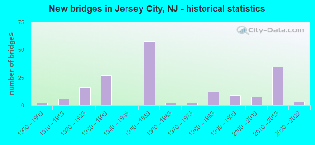
- New bridges - historical statistics
- 21900-1909
- 61910-1919
- 161920-1929
- 271930-1939
- 581950-1959
- 21960-1969
- 21970-1979
- 121980-1989
- 91990-1999
- 82000-2009
- 352010-2019
- 32020-2022
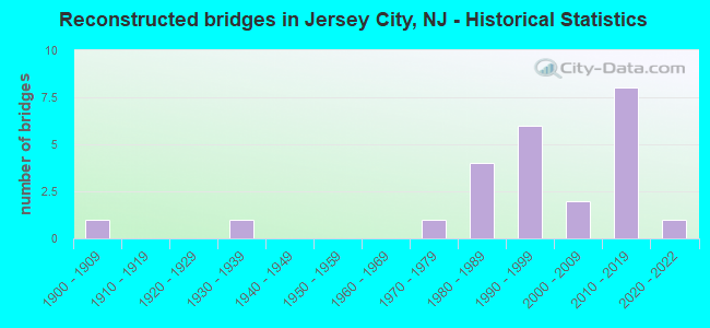
- Reconstructed bridges - Historical Statistics
- 11900-1909
- 01910-1919
- 01920-1929
- 11930-1939
- 01940-1949
- 01950-1959
- 01960-1969
- 11970-1979
- 41980-1989
- 61990-1999
- 22000-2009
- 82010-2019
- 12020-2022
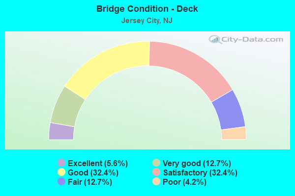
- Bridge Condition - Deck
- 5.6%Excellent
- 12.7%Very good
- 32.4%Good
- 32.4%Satisfactory
- 12.7%Fair
- 4.2%Poor
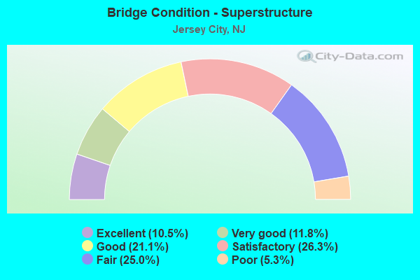
- Bridge Condition - Superstructure
- 10.5%Excellent
- 11.8%Very good
- 21.1%Good
- 26.3%Satisfactory
- 25.0%Fair
- 5.3%Poor
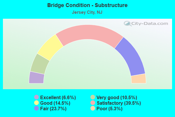
- Bridge Condition - Substructure
- 6.6%Excellent
- 10.5%Very good
- 14.5%Good
- 39.5%Satisfactory
- 23.7%Fair
- 5.3%Poor
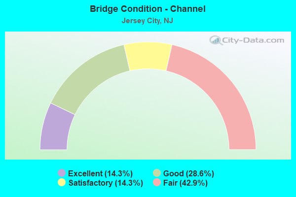
- Bridge Condition - Channel
- 14.3%Excellent
- 28.6%Good
- 14.3%Satisfactory
- 42.9%Fair
Find on map >> Show street view
Structure Number: 91316, Location: 0.5 MILE S.E.OF JFK BLVD. (Lat: 40.688350, Lng: -74.097761), Route carried "on" structure: State highway 440, Year Built: 1991, Status: Open, Structure Length: 2.35m (7.71ft), Average Daily Traffic: 23,570 (year 2020), Truck Traffic: 4%, Average Future Daily Traffic: 28,760 (year 2040), Design Load: HS 20+Mod, Features Intersected: GARFIELD AVENUE
Minimum Vertical Clearance: 30+ m (98+ ft), Kilometerpoint: 36.677, Lanes on structure: 6, Lanes under structure: 2, Base Highway Network: Yes, Owner: State Highway Agency, Approaching Roadway Width: 38.1m (125.0ft), Skew: 30 degrees, Material/Design: Steel, Design/Construction: Stringer/Multi-beam, Number Of Spans In Main Unit: 1, Length of Maximum Span: 22.3m (73.2ft), Curb-To-Curb Width: 38.1m (125.0ft), Out-to-Out Width: 41.7m (136.8ft)
Condition: Deck: Good, Superstructure: Good, Substructure: Satisfactory, Inventory Rating: 62.6 metric tons, Method Used To Determine Inventory Rating: Load Factor (LF), Structural Evaluation: Equal to present minimum criteria, Deck Geometry: Superior to present desirable criteria, Underclear: Better than present minimum criteria, Approach Roadway Alignment: Better than present minimum criteria, Designated Inspection Frequency: Every 24 months, Inspection Date: August 2020, Deck Structure Type: Concrete Cast-file-Place, Wearing Surface/Protective System: Wearing Surface: Latex Concrete, Deck Protection: Epoxy Coated Reinforcing
Find on map >> Show street view
Structure Number: 92215, Location: 0.11 Miles N of NJ 440 (Lat: 40.684911, Lng: -74.092150), Route carried "on" structure: State highway 185, Year Built: 1985, Status: Open, Structure Length: 19.32m (63.39ft), Average Daily Traffic: 13,685 (year 2021), Truck Traffic: 4%, Average Future Daily Traffic: 16,420 (year 2041), Design Load: HS 20+Mod, Features Intersected: NJ 440 NB,Conrail & PJR
Minimum Vertical Clearance: 30+ m (98+ ft), Kilometerpoint: 0.177, Lanes on structure: 4, Lanes under structure: 1, Base Highway Network: Yes, Owner: State Highway Agency, Approaching Roadway Width: 24.7m (81.0ft), Skew: 33 degrees, Material/Design: Steel, Design/Construction: Stringer/Multi-beam, Number Of Spans In Main Unit: 5, Length of Maximum Span: 56.4m (185.0ft), Curb-To-Curb Width: 25.3m (83.0ft), Out-to-Out Width: 27.2m (89.2ft)
Condition: Deck: Good, Superstructure: Good, Substructure: Satisfactory, Operating Rating: 58.1 metric tons, Method Used To Determine Operating Rating: Load Factor (LF), Inventory Rating: 34.5 metric tons, Method Used To Determine Inventory Rating: Load Factor (LF), Structural Evaluation: Equal to present minimum criteria, Deck Geometry: Superior to present desirable criteria, Underclear: Equal to present minimum criteria, Approach Roadway Alignment: Equal to present desirable criteria, Designated Inspection Frequency: Every 24 months, Inspection Date: November 2021, Deck Structure Type: Concrete Cast-file-Place, Wearing Surface/Protective System: Wearing Surface: Monolithic Concrete, Deck Protection: Epoxy Coated Reinforcing
Find on map >> Show street view
Structure Number: 950163, Location: 0.7 MI NW OF NJTPK EX.14B (Lat: 40.711550, Lng: -74.075319), Route carried "on" structure: City street , Year Built: 1900, Year Reconstructed: 1913, Status: Open, Structure Length: 1.52m (4.99ft), Average Daily Traffic: 14,345 (year 2020), Truck Traffic: 4%, Average Future Daily Traffic: 17,214 (year 2040), Design Load: H 20, Features Intersected: HUDSON-BERGEN LIGHT RAIL, Facility Carried by Structure: OCEAN AVE.
Minimum Vertical Clearance: 30+ m (98+ ft), Kilometerpoint: 3.219, Lanes on structure: 2, Owner: State Agenciy, Approaching Roadway Width: 12.2m (40.0ft), Material/Design: Steel, Design/Construction: Girder and Floorbeam System, Number Of Spans In Main Unit: 1, Length of Maximum Span: 14.3m (46.9ft), Curb or Sidewalk Widths: Left: 4.2m (13.8ft), Right: 4.2m (13.8ft), Curb-To-Curb Width: 12.0m (39.4ft), Out-to-Out Width: 21.3m (69.9ft)
Condition: Deck: Good, Superstructure: Fair, Substructure: Fair, Operating Rating: 37.2 metric tons, Method Used To Determine Operating Rating: Load Factor (LF), Inventory Rating: 21.8 metric tons, Method Used To Determine Inventory Rating: Load Factor (LF), Structural Evaluation: Somewhat better than minimum adequacy, Deck Geometry: Somewhat better than minimum adequacy, Underclear: High priority of corrective action, Approach Roadway Alignment: Better than present minimum criteria, Length Of Structure Improvement: 1.52m (4.99ft), Designated Inspection Frequency: Every 24 months, Inspection Date: October 2020, Bridge Improvement Cost: $619,000, Roadway Improvement Cost: $166,000, Total Project Cost: $1,094,000 ( Estimate for 2020), Deck Structure Type: Concrete Cast-file-Place, Wearing Surface/Protective System: Wearing Surface: Latex Concrete
Find on map >> Show street view
Structure Number: 950164, Location: 0.7 MI NW of NJTPK EX 14B (Lat: 40.711211, Lng: -74.074100), Route carried "on" structure: City street , Year Built: 1999, Status: Open, Structure Length: 2.65m (8.69ft), Average Daily Traffic: 3,978 (year 2021), Truck Traffic: 1%, Average Future Daily Traffic: 4,856 (year 2041), Design Load: HS 20+Mod, Features Intersected: NJT Hudson Bergen LT RL, Facility Carried by Structure: Clerk Street
Minimum Vertical Clearance: 30+ m (98+ ft), Kilometerpoint: 0.000, Lanes on structure: 1, Owner: State Agenciy, Approaching Roadway Width: 9.1m (29.9ft), Skew: 3 degrees, Material/Design: Steel, Design/Construction: Stringer/Multi-beam, Number Of Spans In Main Unit: 1, Length of Maximum Span: 24.7m (81.0ft), Curb or Sidewalk Widths: Left: 3.2m (10.5ft), Right: 3.2m (10.5ft), Curb-To-Curb Width: 9.1m (29.9ft), Out-to-Out Width: 16.2m (53.1ft)
Condition: Deck: Good, Superstructure: Good, Substructure: Satisfactory, Operating Rating: 49.0 metric tons, Method Used To Determine Operating Rating: Load Factor (LF), Inventory Rating: 29.0 metric tons, Method Used To Determine Inventory Rating: Load Factor (LF), Structural Evaluation: Equal to present minimum criteria, Deck Geometry: Meets minimum limits, Underclear: High priority of replacement, Approach Roadway Alignment: Equal to present desirable criteria, Length Of Structure Improvement: 3.44m (11.29ft), Designated Inspection Frequency: Every 24 months, Inspection Date: May 2021, Bridge Improvement Cost: $4,743,000, Roadway Improvement Cost: $1,186,000, Total Project Cost: $17,787,000 ( Estimate for 2021), Deck Structure Type: Concrete Cast-file-Place, Wearing Surface/Protective System: Wearing Surface: Monolithic Concrete, Deck Protection: Epoxy Coated Reinforcing
Find on map >> Show street view
Structure Number: 951165, Location: 0.8MI E OF US9&NJ495 JCT (Lat: 40.731361, Lng: -74.053261), Route carried "on" structure: City street , Year Built: 1910, Status: Open, Structure Length: 2.96m (9.71ft), Average Daily Traffic: 10,573 (year 2021), Truck Traffic: 4%, Average Future Daily Traffic: 12,901 (year 2041), Features Intersected: ABND BERGEN CO BRANCH, Facility Carried by Structure: PALISADES AVENUE
Minimum Vertical Clearance: 30+ m (98+ ft), Kilometerpoint: 0.257, Lanes on structure: 3, Maintenance Responsibility: State Highway Agency, Approaching Roadway Width: 11.0m (36.1ft), Material/Design: Concrete, Design/Construction: Arch - Deck, Number Of Spans In Main Unit: 2, Length of Maximum Span: 18.0m (59.1ft), Curb or Sidewalk Widths: Left: 3.7m (12.1ft), Right: 3.5m (11.5ft), Curb-To-Curb Width: 11.0m (36.1ft), Out-to-Out Width: 18.9m (62.0ft)
Condition: Superstructure: Poor, Substructure: Poor, Operating Rating: 79.8 metric tons, Method Used To Determine Operating Rating: Load Factor (LF), Inventory Rating: 47.2 metric tons, Method Used To Determine Inventory Rating: Load Factor (LF), Structural Evaluation: Meets minimum limits, Deck Geometry: High priority of replacement, Approach Roadway Alignment: Equal to present desirable criteria, Length Of Structure Improvement: 2.96m (9.71ft), Designated Inspection Frequency: Every 24 months, Inspection Date: September 2021, Bridge Improvement Cost: $2,128,000, Roadway Improvement Cost: $234,000, Total Project Cost: $3,277,000 ( Estimate for 2021)
Find on map >> Show street view
Structure Number: 951166, Location: 50' South of NJ 139 (Lat: 40.732900, Lng: -74.054981), Route carried "on" structure: City street , Year Built: 1910, Status: Open, Structure Length: 1.71m (5.61ft), Average Daily Traffic: 12,927 (year 2021), Truck Traffic: 4%, Average Future Daily Traffic: 15,773 (year 2041), Features Intersected: BERGEN CO LINE (ABNDND), Facility Carried by Structure: BALDWIN AVENUE
Minimum Vertical Clearance: 30+ m (98+ ft), Kilometerpoint: 0.724, Lanes on structure: 2, Maintenance Responsibility: State Highway Agency, Approaching Roadway Width: 9.1m (29.9ft), Material/Design: Concrete, Design/Construction: Arch - Deck, Number Of Spans In Main Unit: 1, Length of Maximum Span: 17.1m (56.1ft), Curb or Sidewalk Widths: Left: 3.0m (9.8ft), Right: 3.0m (9.8ft), Curb-To-Curb Width: 9.2m (30.2ft), Out-to-Out Width: 15.9m (52.2ft)
Condition: Superstructure: Fair, Substructure: Fair, Inventory Rating: 64.4 metric tons, Method Used To Determine Inventory Rating: Load Factor (LF), Structural Evaluation: Somewhat better than minimum adequacy, Deck Geometry: High priority of corrective action, Approach Roadway Alignment: Better than present minimum criteria, Designated Inspection Frequency: Every 24 months, Inspection Date: September 2021
Find on map >> Show street view
Structure Number: 95416, Location: 0.26 Mi S of RT 1+9T (Lat: 40.735350, Lng: -74.067000), Route carried "on" structure: City street , Year Built: 1936, Status: Open, Structure Length: 2.74m (8.99ft), Average Daily Traffic: 11,620 (year 2020), Truck Traffic: 4%, Average Future Daily Traffic: 14,180 (year 2040), Features Intersected: Passaic & Harimus Branch, Facility Carried by Structure: Tonnele Avenue
Minimum Vertical Clearance: 30+ m (98+ ft), Kilometerpoint: 0.418, Lanes on structure: 2, Maintenance Responsibility: State Highway Agency, Approaching Roadway Width: 10.7m (35.1ft), Skew: 1 degrees, Material/Design: Steel continuous, Design/Construction: Stringer/Multi-beam, Number Of Spans In Main Unit: 2, Length of Maximum Span: 16.2m (53.1ft), Curb or Sidewalk Widths: Left: 2.3m (7.5ft), Right: 2.3m (7.5ft), Curb-To-Curb Width: 10.7m (35.1ft), Out-to-Out Width: 15.8m (51.8ft)
Condition: Deck: Satisfactory, Superstructure: Satisfactory, Substructure: Satisfactory, Operating Rating: 35.4 metric tons, Method Used To Determine Operating Rating: Load Factor (LF), Inventory Rating: 20.9 metric tons, Method Used To Determine Inventory Rating: Load Factor (LF), Structural Evaluation: Somewhat better than minimum adequacy, Deck Geometry: Meets minimum limits, Underclear: High priority of corrective action, Approach Roadway Alignment: Equal to present desirable criteria, Length Of Structure Improvement: 2.74m (8.99ft), Designated Inspection Frequency: Every 24 months, Inspection Date: July 2020, Bridge Improvement Cost: $851,000, Roadway Improvement Cost: $175,000, Total Project Cost: $1,698,000 ( Estimate for 2020), Deck Structure Type: Concrete Cast-file-Place, Wearing Surface/Protective System: Wearing Surface: Bituminous
Find on map >> Show street view
Structure Number: 954162, Location: 0.47 MI S of RT 139 (Lat: 40.730592, Lng: -74.061228), Route carried "on" structure: City street , Year Built: 1924, Year Reconstructed: 1988, Status: Open, Structure Length: 5.79m (19.00ft), Average Daily Traffic: 15,560 (year 2020), Truck Traffic: 4%, Average Future Daily Traffic: 18,990 (year 2040), Features Intersected: Passaic & Harimus Branch, Facility Carried by Structure: Summit Avenue
Minimum Vertical Clearance: 30+ m (98+ ft), Kilometerpoint: 1.786, Lanes on structure: 2, Maintenance Responsibility: State Highway Agency, Approaching Roadway Width: 11.0m (36.1ft), Material/Design: Concrete continuous, Design/Construction: Stringer/Multi-beam, Number Of Spans In Main Unit: 2, Length of Maximum Span: 28.7m (94.2ft), Curb or Sidewalk Widths: Left: 2.5m (8.2ft), Right: 2.4m (7.9ft), Curb-To-Curb Width: 11.0m (36.1ft), Out-to-Out Width: 16.9m (55.4ft)
Condition: Deck: Satisfactory, Superstructure: Satisfactory, Substructure: Satisfactory, Operating Rating: 63.5 metric tons, Method Used To Determine Operating Rating: Load Factor (LF), Inventory Rating: 38.1 metric tons, Method Used To Determine Inventory Rating: Load Factor (LF), Structural Evaluation: Equal to present minimum criteria, Deck Geometry: Meets minimum limits, Underclear: Meets minimum limits, Approach Roadway Alignment: Equal to present desirable criteria, Designated Inspection Frequency: Every 24 months, Inspection Date: July 2020, Deck Structure Type: Concrete Cast-file-Place, Wearing Surface/Protective System: Wearing Surface: Bituminous
Find on map >> Show street view
Structure Number: 954163, Location: 0.4 MI S of RT 139 (Lat: 40.729331, Lng: -74.059911), Route carried "on" structure: City street , Year Built: 1928, Year Reconstructed: 1990, Status: Open, Structure Length: 5.06m (16.60ft), Average Daily Traffic: 38,705 (year 2020), Truck Traffic: 4%, Average Future Daily Traffic: 46,750 (year 2040), Features Intersected: Conrail & Path, Facility Carried by Structure: Baldwin Avenue
Minimum Vertical Clearance: 30+ m (98+ ft), Kilometerpoint: 1.304, Lanes on structure: 2, Maintenance Responsibility: State Highway Agency, Approaching Roadway Width: 9.8m (32.2ft), Skew: 1 degrees, Material/Design: Steel, Design/Construction: Girder and Floorbeam System, Number Of Spans In Main Unit: 2, Number Of Approach Spans: 1, Length of Maximum Span: 21.9m (71.9ft), Curb or Sidewalk Widths: Left: 2.0m (6.6ft), Right: 2.0m (6.6ft), Curb-To-Curb Width: 9.8m (32.2ft), Out-to-Out Width: 10.3m (33.8ft)
Condition: Deck: Poor, Superstructure: Poor, Substructure: Poor, Operating Rating: 33.6 metric tons, Method Used To Determine Operating Rating: Load Factor (LF), Inventory Rating: 20.0 metric tons, Method Used To Determine Inventory Rating: Load Factor (LF), Structural Evaluation: Meets minimum limits, Deck Geometry: Meets minimum limits, Underclear: High priority of replacement, Approach Roadway Alignment: Equal to present minimum criteria, Length Of Structure Improvement: 6.10m (20.01ft), Designated Inspection Frequency: Every 24 months, Critical Feature Inspection Frequency: Every 24 months, Inspection Date: July 2020, Critical Feature Inspection Date: July 2020, Bridge Improvement Cost: $2,367,000, Roadway Improvement Cost: $159,000, Total Project Cost: $5,473,000 ( Estimate for 2020), Deck Structure Type: Concrete Cast-file-Place, Wearing Surface/Protective System: Wearing Surface: Bituminous
Find on map >> Show street view
Structure Number: 954164, Location: 1600FT SE OF JOURNAL SQ. (Lat: 40.728150, Lng: -74.058369), Route carried "on" structure: City street CR693, Year Built: 1918, Year Reconstructed: 1985, Status: Open, Structure Length: 3.14m (10.30ft), Average Daily Traffic: 1,170 (year 2021), Truck Traffic: 1%, Average Future Daily Traffic: 1,404 (year 2041), Features Intersected: PATH&CONRAIL, Facility Carried by Structure: CHESTNUT AVENUE
Minimum Vertical Clearance: 30+ m (98+ ft), Kilometerpoint: 0.000, Lanes on structure: 2, Owner: County Highway Agency, Approaching Roadway Width: 9.1m (29.9ft), Material/Design: Steel, Design/Construction: Girder and Floorbeam System, Number Of Spans In Main Unit: 1, Length of Maximum Span: 29.3m (96.1ft), Curb or Sidewalk Widths: Left: 2.3m (7.5ft), Right: 2.3m (7.5ft), Curb-To-Curb Width: 9.1m (29.9ft), Out-to-Out Width: 9.4m (30.8ft)
Condition: Deck: Satisfactory, Superstructure: Satisfactory, Substructure: Satisfactory, Operating Rating: 55.3 metric tons, Method Used To Determine Operating Rating: Load Factor (LF), Inventory Rating: 33.6 metric tons, Method Used To Determine Inventory Rating: Load Factor (LF), Structural Evaluation: Equal to present minimum criteria, Deck Geometry: Somewhat better than minimum adequacy, Underclear: Somewhat better than minimum adequacy, Approach Roadway Alignment: Equal to present desirable criteria, Designated Inspection Frequency: Every 24 months, Critical Feature Inspection Frequency: Every 24 months, Inspection Date: Febuary 2021, Critical Feature Inspection Date: Febuary 2021, Deck Structure Type: Concrete Cast-file-Place, Wearing Surface/Protective System: Wearing Surface: Monolithic Concrete, Deck Protection: Epoxy Coated Reinforcing
Find on map >> Show street view
Structure Number: 95816, Location: 0.1MI SE OF NJTPK INT 14B (Lat: 40.700131, Lng: -74.068511), Route carried "on" structure: City street , Year Built: 1976, Year Reconstructed: 2020, Status: Open, Structure Length: 2.71m (8.89ft), Average Daily Traffic: 23,333 (year 2021), Truck Traffic: 3%, Average Future Daily Traffic: 28,471 (year 2041), Design Load: HL 93, Features Intersected: NATIONAL STORAGE BRANCH, Facility Carried by Structure: CAVEN POINT ROAD
Minimum Vertical Clearance: 30+ m (98+ ft), Kilometerpoint: 0.000, Lanes on structure: 3, Maintenance Responsibility: State Highway Agency, Approaching Roadway Width: 14.6m (47.9ft), Material/Design: Steel continuous, Design/Construction: Stringer/Multi-beam, Number Of Spans In Main Unit: 3, Length of Maximum Span: 8.8m (28.9ft), Curb or Sidewalk Widths: Left: 0.0m, Right: 1.5m (4.9ft), Curb-To-Curb Width: 14.7m (48.2ft), Out-to-Out Width: 17.1m (56.1ft)
Condition: Deck: Excellent, Superstructure: Excellent, Substructure: Very good, Operating Rating: 96.9 metric tons, Method Used To Determine Operating Rating: Load and Resistance Factor Rating (LRFR) rating reported by rating factor(RF) method using HL-93 loadings, Inventory Rating: 85.9 metric tons, Method Used To Determine Inventory Rating: Load and Resistance Factor Rating (LRFR) rating reported by rating factor(RF) method using HL-93 loadings, Structural Evaluation: Equal to present desirable criteria, Deck Geometry: Somewhat better than minimum adequacy, Underclear: High priority of corrective action, Approach Roadway Alignment: Equal to present minimum criteria, Length Of Structure Improvement: 2.77m (9.09ft), Designated Inspection Frequency: Every 24 months, Inspection Date: September 2021, Bridge Improvement Cost: $2,119,000, Roadway Improvement Cost: $133,000, Total Project Cost: $3,456,000 ( Estimate for 2019), Deck Structure Type: Concrete Precast Panels, Wearing Surface/Protective System: Wearing Surface: Monolithic Concrete, Deck Protection: Epoxy Coated Reinforcing
Find on map >> Show street view
Structure Number: 962154, Location: 0.92MI NE NJTPK EXIT 14A (Lat: 40.694969, Lng: -74.083600), Route carried "on" structure: City street , Year Built: 1997, Status: Open, Structure Length: 3.20m (10.50ft), Average Daily Traffic: 3,396 (year 2021), Truck Traffic: 1%, Average Future Daily Traffic: 4,143 (year 2041), Design Load: HS 20+Mod, Features Intersected: HBLR&CONRAIL, Facility Carried by Structure: CHAPEL AVENUE
Minimum Vertical Clearance: 30+ m (98+ ft), Kilometerpoint: 0.000, Lanes on structure: 2, Owner: State Agenciy, Approaching Roadway Width: 10.7m (35.1ft), Material/Design: Steel continuous, Design/Construction: Stringer/Multi-beam, Number Of Spans In Main Unit: 2, Length of Maximum Span: 15.2m (49.9ft), Curb or Sidewalk Widths: Left: 1.8m (5.9ft), Right: 1.8m (5.9ft), Curb-To-Curb Width: 10.7m (35.1ft), Out-to-Out Width: 14.9m (48.9ft)
Condition: Deck: Good, Superstructure: Good, Substructure: Good, Inventory Rating: 79.8 metric tons, Method Used To Determine Inventory Rating: Load Factor (LF), Structural Evaluation: Better than present minimum criteria, Deck Geometry: Somewhat better than minimum adequacy, Underclear: High priority of corrective action, Approach Roadway Alignment: Equal to present desirable criteria, Length Of Structure Improvement: 3.26m (10.70ft), Designated Inspection Frequency: Every 24 months, Inspection Date: Febuary 2021, Bridge Improvement Cost: $900,000, Roadway Improvement Cost: $180,000, Total Project Cost: $1,864,000 ( Estimate for 2021), Deck Structure Type: Concrete Cast-file-Place, Wearing Surface/Protective System: Wearing Surface: Monolithic Concrete, Deck Protection: Epoxy Coated Reinforcing
Find on map >> Show street view
Structure Number: 962155, Location: 0.57MI NE NJTPK EXIT 14A (Lat: 40.691369, Lng: -74.088231), Route carried "on" structure: City street , Year Built: 1993, Status: Open, Structure Length: 3.93m (12.89ft), Average Daily Traffic: 8,237 (year 2021), Truck Traffic: 1%, Average Future Daily Traffic: 10,050 (year 2041), Design Load: HS 20+Mod, Features Intersected: HBLR & CONRAIL (MP 3.27), Facility Carried by Structure: LINDEN AVENUE
Minimum Vertical Clearance: 30+ m (98+ ft), Kilometerpoint: 0.000, Lanes on structure: 2, Owner: State Agenciy, Approaching Roadway Width: 10.7m (35.1ft), Skew: 1 degrees, Material/Design: Prestressed concrete, Design/Construction: Slab, Number Of Spans In Main Unit: 3, Length of Maximum Span: 14.9m (48.9ft), Curb or Sidewalk Widths: Left: 1.8m (5.9ft), Right: 1.8m (5.9ft), Curb-To-Curb Width: 10.7m (35.1ft), Out-to-Out Width: 14.9m (48.9ft)
Condition: Deck: Good, Superstructure: Good, Substructure: Satisfactory, Operating Rating: 75.3 metric tons, Method Used To Determine Operating Rating: Load Factor (LF), Inventory Rating: 45.4 metric tons, Method Used To Determine Inventory Rating: Load Factor (LF), Structural Evaluation: Equal to present minimum criteria, Deck Geometry: Meets minimum limits, Underclear: High priority of corrective action, Approach Roadway Alignment: Equal to present minimum criteria, Length Of Structure Improvement: 3.93m (12.89ft), Designated Inspection Frequency: Every 24 months, Inspection Date: Febuary 2021, Bridge Improvement Cost: $945,000, Roadway Improvement Cost: $189,000, Total Project Cost: $1,957,000 ( Estimate for 2021), Deck Structure Type: Concrete Cast-file-Place, Wearing Surface/Protective System: Wearing Surface: Monolithic Concrete, Membrane: Epoxy, Deck Protection: Epoxy Coated Reinforcing
Find on map >> Show street view
Structure Number: 100002, Location: 290 ft. east of CR 615 (Lat: 40.577469, Lng: -74.960719), Route carried "on" structure: County highway 579, Year Built: 1984, Status: Open, Structure Length: 1.10m (3.61ft), Average Daily Traffic: 3,736 (year 2021), Truck Traffic: 3%, Average Future Daily Traffic: 4,484 (year 2041), Design Load: HS 20, Features Intersected: CAPOOLONG CREEK
Minimum Vertical Clearance: 30+ m (98+ ft), Kilometerpoint: 44.080, Lanes on structure: 2, Owner: County Highway Agency, Approaching Roadway Width: 9.8m (32.2ft), Material/Design: Prestressed concrete, Design/Construction: Slab, Number Of Spans In Main Unit: 1, Length of Maximum Span: 10.1m (33.1ft), Curb or Sidewalk Widths: Left: 0.2m (0.7ft), Right: 0.2m (0.7ft), Curb-To-Curb Width: 9.8m (32.2ft), Out-to-Out Width: 11.0m (36.1ft)
Condition: Deck: Satisfactory, Superstructure: Very good, Substructure: Satisfactory, Channel: Fair, Operating Rating: 55.3 metric tons, Method Used To Determine Operating Rating: Load Factor (LF), Inventory Rating: 28.1 metric tons, Method Used To Determine Inventory Rating: Load Factor (LF), Structural Evaluation: Equal to present minimum criteria, Deck Geometry: Meets minimum limits, Waterway Adequacy: Superior to present desirable criteria, Approach Roadway Alignment: Equal to present desirable criteria, Designated Inspection Frequency: Every 24 months, Inspection Date: March 2021, Deck Structure Type: Concrete Cast-file-Place, Wearing Surface/Protective System: Wearing Surface: Monolithic Concrete, Deck Protection: Epoxy Coated Reinforcing
Find on map >> Show street view
Structure Number: 110002, Location: 1.2 mile West of US 1 (Lat: 40.296089, Lng: -74.704911), Route carried "on" structure: County highway 583, Year Built: 1953, Status: Open, Structure Length: 1.04m (3.41ft), Average Daily Traffic: 18,605 (year 2021), Truck Traffic: 4%, Average Future Daily Traffic: 22,700 (year 2041), Features Intersected: SHIPETAUKIN CREEK
Minimum Vertical Clearance: 30+ m (98+ ft), Kilometerpoint: 7.773, Lanes on structure: 2, Owner: County Highway Agency, Approaching Roadway Width: 7.0m (23.0ft), Material/Design: Steel, Design/Construction: Stringer/Multi-beam, Number Of Spans In Main Unit: 1, Length of Maximum Span: 9.8m (32.2ft), Curb or Sidewalk Widths: Left: 0.3m (1.0ft), Right: 1.2m (3.9ft), Curb-To-Curb Width: 12.2m (40.0ft), Out-to-Out Width: 14.4m (47.2ft)
Condition: Deck: Satisfactory, Superstructure: Satisfactory, Substructure: Satisfactory, Channel: Fair, Operating Rating: 58.1 metric tons, Method Used To Determine Operating Rating: Load Factor (LF), Inventory Rating: 34.5 metric tons, Method Used To Determine Inventory Rating: Load Factor (LF), Structural Evaluation: Equal to present minimum criteria, Deck Geometry: Somewhat better than minimum adequacy, Waterway Adequacy: Equal to present minimum criteria, Approach Roadway Alignment: Equal to present desirable criteria, Designated Inspection Frequency: Every 24 months, Inspection Date: Febuary 2021, Deck Structure Type: Concrete Cast-file-Place, Wearing Surface/Protective System: Wearing Surface: Bituminous
Find on map >> Show street view
Structure Number: 382304C, Location: Jersey City, NJ (Lat: 40.634431, Lng: -74.144950), Route carried "on" structure: State highway 440, Year Built: 2017, Status: Open, Structure Length: 72.57m (238.09ft), Average Daily Traffic: 26,420 (year 2021), Truck Traffic: 4%, Average Future Daily Traffic: 32,232 (year 2041), Design Load: HL 93, Features Intersected: Innis Street
Minimum Vertical Clearance: 30+ m (98+ ft), Kilometerpoint: 0.000, Lanes on structure: 2, Lanes under structure: 5, Base Highway Network: Yes, Toll: Toll bridge, Owner: Private, Approaching Roadway Width: 14.6m (47.9ft), Navigation Control: Yes ( Vertical Clearance: 30.2m (99.1ft), Horizontal Clearance: 30.2m (99.1ft)), Material/Design: Prestressed concrete, Design/Construction: Segmental Box Girder, Number Of Spans In Main Unit: 12, Length of Maximum Span: 82.9m (272.0ft), Curb or Sidewalk Widths: Left: 2.0m (6.6ft), Right: 2.0m (6.6ft), Curb-To-Curb Width: 11.0m (36.1ft), Out-to-Out Width: 18.1m (59.4ft)
Condition: Deck: Very good, Superstructure: Good, Substructure: Very good, Operating Rating: 85.5 metric tons, Method Used To Determine Operating Rating: Load and Resistance Factor Rating (LRFR) rating reported by rating factor(RF) method using HL-93 loadings, Inventory Rating: 37.6 metric tons, Method Used To Determine Inventory Rating: Load and Resistance Factor Rating (LRFR) rating reported by rating factor(RF) method using HL-93 loadings, Structural Evaluation: Better than present minimum criteria, Deck Geometry: Somewhat better than minimum adequacy, Underclear: Equal to present desirable criteria, Approach Roadway Alignment: Superior to present desirable criteria, Designated Inspection Frequency: Every 24 months, Inspection Date: September 2021, Wearing Surface/Protective System: Wearing Surface: Monolithic Concrete
Find on map >> Show street view
Structure Number: N00324, Location: 1 MI E OF NEWARK BAY (Lat: 40.688333, Lng: -74.103333), Route carried "on" structure: Interstate 78, Year Built: 1954, Year Reconstructed: 2016, Status: Open, Structure Length: 3.38m (11.09ft), Average Daily Traffic: 95,800 (year 2020), Truck Traffic: 9%, Average Future Daily Traffic: 116,850 (year 2040), Design Load: HS 20, Features Intersected: AVENUE C, Facility Carried by Structure: NJ TPK HUD.CO.EXT.
Minimum Vertical Clearance: 30+ m (98+ ft), Kilometerpoint: 99.345, Lanes on structure: 6, Lanes under structure: 4, Base Highway Network: Yes, Toll: On toll road, Owner: State Toll Authority, Approaching Roadway Width: 36.0m (118.1ft), Skew: 31 degrees, Material/Design: Steel, Design/Construction: Stringer/Multi-beam, Number Of Spans In Main Unit: 1, Length of Maximum Span: 33.8m (110.9ft), Curb-To-Curb Width: 36.0m (118.1ft), Out-to-Out Width: 38.8m (127.3ft)
Condition: Deck: Satisfactory, Superstructure: Satisfactory, Substructure: Satisfactory, Operating Rating: 28.2 metric tons, Method Used To Determine Operating Rating: Load and Resistance Factor Rating (LRFR) rating reported by rating factor(RF) method using HL-93 loadings, Inventory Rating: 21.7 metric tons, Method Used To Determine Inventory Rating: Load and Resistance Factor Rating (LRFR) rating reported by rating factor(RF) method using HL-93 loadings, Structural Evaluation: Somewhat better than minimum adequacy, Deck Geometry: Superior to present desirable criteria, Underclear: High priority of replacement, Approach Roadway Alignment: Equal to present desirable criteria, Length Of Structure Improvement: 4.33m (14.21ft), Designated Inspection Frequency: Every 24 months, Inspection Date: June 2020, Bridge Improvement Cost: $750,000, Roadway Improvement Cost: $250,000, Total Project Cost: $1,000,000 ( Estimate for 2018), Deck Structure Type: Concrete Cast-file-Place, Wearing Surface/Protective System: Wearing Surface: Bituminous, Membrane: Other
Find on map >> Show street view
Structure Number: N00339, Location: I-SEC.RT.440 & HUD.CO.EXT (Lat: 40.686939, Lng: -74.098950), Route carried "on" structure: Interstate 78, Year Built: 1955, Status: Open, Structure Length: 2.38m (7.81ft), Average Daily Traffic: 95,790 (year 2020), Truck Traffic: 10%, Average Future Daily Traffic: 116,850 (year 2040), Design Load: HS 20, Features Intersected: GARFIELD AVENUE, Facility Carried by Structure: NJ TPK HUD.CO.EXT.
Minimum Vertical Clearance: 30+ m (98+ ft), Kilometerpoint: 99.634, Lanes on structure: 4, Lanes under structure: 2, Base Highway Network: Yes, Toll: On toll road, Owner: State Toll Authority, Approaching Roadway Width: 23.8m (78.1ft), Skew: 30 degrees, Material/Design: Steel, Design/Construction: Stringer/Multi-beam, Number Of Spans In Main Unit: 1, Length of Maximum Span: 22.3m (73.2ft), Curb or Sidewalk Widths: Left: 0.6m (2.0ft), Right: 0.6m (2.0ft), Curb-To-Curb Width: 23.3m (76.4ft), Out-to-Out Width: 26.7m (87.6ft)
Condition: Deck: Satisfactory, Superstructure: Satisfactory, Substructure: Fair, Operating Rating: 49.2 metric tons, Method Used To Determine Operating Rating: Load and Resistance Factor Rating (LRFR) rating reported by rating factor(RF) method using HL-93 loadings, Inventory Rating: 37.9 metric tons, Method Used To Determine Inventory Rating: Load and Resistance Factor Rating (LRFR) rating reported by rating factor(RF) method using HL-93 loadings, Structural Evaluation: Somewhat better than minimum adequacy, Deck Geometry: Superior to present desirable criteria, Underclear: Equal to present minimum criteria, Approach Roadway Alignment: Equal to present desirable criteria, Designated Inspection Frequency: Every 24 months, Inspection Date: June 2020, Deck Structure Type: Concrete Cast-file-Place, Wearing Surface/Protective System: Wearing Surface: Bituminous, Membrane: Other
Find on map >> Show street view
Structure Number: N00353B, Location: I-SEC RT.440 &HUD.CO.EXT. (Lat: 40.686836, Lng: -74.099044), Route carried "on" structure: Ramp Interstate 78, Year Built: 1955, Status: Open, Structure Length: 2.38m (7.81ft), Average Daily Traffic: 18,675 (year 2020), Truck Traffic: 13%, Average Future Daily Traffic: 22,780 (year 2040), Design Load: HS 20, Features Intersected: GARFIELD AVENUE, Facility Carried by Structure: TPK HCE IN14A RPWT
Minimum Vertical Clearance: 30+ m (98+ ft), Kilometerpoint: 99.795, Lanes on structure: 1, Lanes under structure: 2, Toll: On toll road, Owner: State Toll Authority, Approaching Roadway Width: 8.5m (27.9ft), Material/Design: Steel, Design/Construction: Stringer/Multi-beam, Number Of Spans In Main Unit: 1, Length of Maximum Span: 22.3m (73.2ft), Curb or Sidewalk Widths: Left: 0.6m (2.0ft), Right: 0.6m (2.0ft), Curb-To-Curb Width: 8.5m (27.9ft), Out-to-Out Width: 10.4m (34.1ft)
Condition: Deck: Good, Superstructure: Satisfactory, Substructure: Satisfactory, Operating Rating: 47.0 metric tons, Method Used To Determine Operating Rating: Load and Resistance Factor Rating (LRFR) rating reported by rating factor(RF) method using HL-93 loadings, Inventory Rating: 41.1 metric tons, Method Used To Determine Inventory Rating: Load and Resistance Factor Rating (LRFR) rating reported by rating factor(RF) method using HL-93 loadings, Structural Evaluation: Equal to present minimum criteria, Deck Geometry: Superior to present desirable criteria, Underclear: Equal to present minimum criteria, Approach Roadway Alignment: Equal to present desirable criteria, Length Of Structure Improvement: 2.38m (7.81ft), Designated Inspection Frequency: Every 24 months, Inspection Date: June 2020, Bridge Improvement Cost: $300,000, Roadway Improvement Cost: $50,000, Total Project Cost: $400,000 ( Estimate for 2016), Deck Structure Type: Concrete Cast-file-Place, Wearing Surface/Protective System: Wearing Surface: Bituminous, Membrane: Other
Find on map >> Show street view
Structure Number: N00353C, Location: I-SEC.RT.440 &HUD.CO.EXT. (Lat: 40.687831, Lng: -74.098211), Route carried "on" structure: Ramp Interstate 78, Year Built: 1954, Year Reconstructed: 2017, Status: Open, Structure Length: 2.56m (8.40ft), Average Daily Traffic: 17,950 (year 2020), Truck Traffic: 13%, Average Future Daily Traffic: 21,900 (year 2040), Design Load: HS 20, Features Intersected: GARFIELD AVENUE, Facility Carried by Structure: TPK HCE IN14A RPTW
Minimum Vertical Clearance: 30+ m (98+ ft), Kilometerpoint: 99.795, Lanes on structure: 1, Lanes under structure: 2, Toll: On toll road, Owner: State Toll Authority, Approaching Roadway Width: 13.2m (43.3ft), Skew: 2 degrees, Material/Design: Steel, Design/Construction: Stringer/Multi-beam, Number Of Spans In Main Unit: 1, Length of Maximum Span: 24.1m (79.1ft), Curb-To-Curb Width: 13.2m (43.3ft), Out-to-Out Width: 14.3m (46.9ft)
Condition: Deck: Very good, Superstructure: Satisfactory, Substructure: Good, Operating Rating: 52.2 metric tons, Method Used To Determine Operating Rating: Load and Resistance Factor Rating (LRFR) rating reported by rating factor(RF) method using HL-93 loadings, Inventory Rating: 40.2 metric tons, Method Used To Determine Inventory Rating: Load and Resistance Factor Rating (LRFR) rating reported by rating factor(RF) method using HL-93 loadings, Structural Evaluation: Equal to present minimum criteria, Deck Geometry: Superior to present desirable criteria, Underclear: Somewhat better than minimum adequacy, Approach Roadway Alignment: Equal to present desirable criteria, Designated Inspection Frequency: Every 24 months, Inspection Date: June 2020, Deck Structure Type: Concrete Cast-file-Place, Wearing Surface/Protective System: Wearing Surface: Monolithic Concrete, Deck Protection: Epoxy Coated Reinforcing
Find on map >> Show street view
Structure Number: N00353D, Location: 1.5 MI E OF NEWARK BAY (Lat: 40.685700, Lng: -74.096119), Route carried "on" structure: Ramp Interstate 78, Year Built: 1955, Status: Open, Structure Length: 29.93m (98.20ft), Average Daily Traffic: 6,315 (year 2020), Truck Traffic: 9%, Average Future Daily Traffic: 7,706 (year 2040), Design Load: HS 20, Features Intersected: NJ RTE.440 & CONRAIL, Facility Carried by Structure: TPK HCE IN14A RPTE
Minimum Vertical Clearance: 30+ m (98+ ft), Kilometerpoint: 99.795, Lanes on structure: 1, Lanes under structure: 5, Toll: On toll road, Owner: State Toll Authority, Approaching Roadway Width: 8.5m (27.9ft), Skew: 9 degrees, Material/Design: Steel, Design/Construction: Stringer/Multi-beam, Number Of Spans In Main Unit: 12, Length of Maximum Span: 32.6m (107.0ft), Curb or Sidewalk Widths: Left: 0.6m (2.0ft), Right: 0.6m (2.0ft), Curb-To-Curb Width: 8.5m (27.9ft), Out-to-Out Width: 10.4m (34.1ft)
Condition: Deck: Fair, Superstructure: Fair, Substructure: Satisfactory, Operating Rating: 22.0 metric tons, Method Used To Determine Operating Rating: Load and Resistance Factor Rating (LRFR) rating reported by rating factor(RF) method using HL-93 loadings, Inventory Rating: 16.8 metric tons, Method Used To Determine Inventory Rating: Load and Resistance Factor Rating (LRFR) rating reported by rating factor(RF) method using HL-93 loadings, Structural Evaluation: Meets minimum limits, Deck Geometry: Superior to present desirable criteria, Underclear: Meets minimum limits, Approach Roadway Alignment: Equal to present minimum criteria, Designated Inspection Frequency: Every 24 months, Inspection Date: June 2020, Deck Structure Type: Concrete Cast-file-Place, Wearing Surface/Protective System: Wearing Surface: Bituminous, Membrane: Other
Find on map >> Show street view
Structure Number: N00353H, Location: 1.07 Mile E of Newark Bay (Lat: 40.681361, Lng: -74.096778), Route carried "on" structure: Ramp Interstate 78, Year Built: 2017, Status: Open, Structure Length: 13.53m (44.39ft), Average Daily Traffic: 22,820 (year 2020), Truck Traffic: 10%, Average Future Daily Traffic: 27,845 (year 2040), Design Load: HL 93, Features Intersected: Route 440, Facility Carried by Structure: RAMPS PORT/TP-440
Minimum Vertical Clearance: 30+ m (98+ ft), Kilometerpoint: 99.795, Lanes on structure: 2, Lanes under structure: 6, Owner: State Toll Authority, Approaching Roadway Width: 10.1m (33.1ft), Skew: 9 degrees, Material/Design: Steel continuous, Design/Construction: Stringer/Multi-beam, Number Of Spans In Main Unit: 4, Length of Maximum Span: 40.5m (132.9ft), Curb-To-Curb Width: 10.1m (33.1ft), Out-to-Out Width: 11.2m (36.7ft)
Condition: Deck: Very good, Superstructure: Excellent, Substructure: Excellent, Operating Rating: 61.6 metric tons, Method Used To Determine Operating Rating: Load and Resistance Factor Rating (LRFR) rating reported by rating factor(RF) method using HL-93 loadings, Inventory Rating: 47.3 metric tons, Method Used To Determine Inventory Rating: Load and Resistance Factor Rating (LRFR) rating reported by rating factor(RF) method using HL-93 loadings, Structural Evaluation: Superior to present desirable criteria, Deck Geometry: Equal to present minimum criteria, Underclear: Somewhat better than minimum adequacy, Approach Roadway Alignment: Equal to present minimum criteria, Designated Inspection Frequency: Every 24 months, Inspection Date: April 2020, Deck Structure Type: Concrete Cast-file-Place, Wearing Surface/Protective System: Deck Protection: Epoxy Coated Reinforcing
Find on map >> Show street view
Structure Number: N00353I, Location: 1.10 Mile E of Newark Bay (Lat: 40.679583, Lng: -74.095222), Route carried "on" structure: Ramp Interstate 78, Year Built: 2017, Status: Open, Structure Length: 4.57m (14.99ft), Average Daily Traffic: 4,000 (year 2020), Truck Traffic: 10%, Average Future Daily Traffic: 4,880 (year 2040), Design Load: HL 93, Features Intersected: PORT JERSEY BLVD, Facility Carried by Structure: INT 14A Ramp TP-44
Minimum Vertical Clearance: 30+ m (98+ ft), Kilometerpoint: 99.795, Lanes on structure: 1, Lanes under structure: 6, Toll: On toll road, Owner: State Toll Authority, Approaching Roadway Width: 12.8m (42.0ft), Skew: 9 degrees, Material/Design: Steel, Design/Construction: Stringer/Multi-beam, Number Of Spans In Main Unit: 1, Length of Maximum Span: 44.2m (145.0ft), Curb-To-Curb Width: 12.9m (42.3ft), Out-to-Out Width: 14.0m (45.9ft)
Condition: Deck: Excellent, Superstructure: Excellent, Substructure: Very good, Operating Rating: 42.1 metric tons, Method Used To Determine Operating Rating: Load and Resistance Factor Rating (LRFR) rating reported by rating factor(RF) method using HL-93 loadings, Inventory Rating: 32.4 metric tons, Method Used To Determine Inventory Rating: Load and Resistance Factor Rating (LRFR) rating reported by rating factor(RF) method using HL-93 loadings, Structural Evaluation: Equal to present desirable criteria, Deck Geometry: Superior to present desirable criteria, Underclear: Somewhat better than minimum adequacy, Approach Roadway Alignment: Equal to present minimum criteria, Designated Inspection Frequency: Every 24 months, Inspection Date: April 2020, Deck Structure Type: Concrete Cast-file-Place, Wearing Surface/Protective System: Deck Protection: Epoxy Coated Reinforcing
Find on map >> Show street view
Structure Number: N00373, Location: 1.7 MI E OF NEWARK BAY (Lat: 40.686239, Lng: -74.092419), Route carried "on" structure: Interstate 78, Year Built: 1955, Status: Open, Structure Length: 69.46m (227.89ft), Average Daily Traffic: 74,100 (year 2020), Truck Traffic: 9%, Average Future Daily Traffic: 90,375 (year 2040), Design Load: HS 20, Features Intersected: NJ440,RAMPS ET-TW &RR, Facility Carried by Structure: NJ TPK HUD.CO.EXT.
Minimum Vertical Clearance: 30+ m (98+ ft), Kilometerpoint: 99.795, Lanes on structure: 4, Lanes under structure: 8, Base Highway Network: Yes, Toll: On toll road, Owner: State Toll Authority, Approaching Roadway Width: 23.8m (78.1ft), Skew: 39 degrees, Material/Design: Steel continuous, Design/Construction: Stringer/Multi-beam, Number Of Spans In Main Unit: 28, Length of Maximum Span: 38.4m (126.0ft), Curb or Sidewalk Widths: Left: 0.0m, Right: 0.6m (2.0ft), Curb-To-Curb Width: 23.8m (78.1ft), Out-to-Out Width: 25.6m (84.0ft)
Condition: Deck: Fair, Superstructure: Fair, Substructure: Fair, Operating Rating: 33.6 metric tons, Method Used To Determine Operating Rating: Load Factor (LF), Inventory Rating: 20.0 metric tons, Method Used To Determine Inventory Rating: Load Factor (LF), Structural Evaluation: Somewhat better than minimum adequacy, Deck Geometry: Superior to present desirable criteria, Underclear: High priority of corrective action, Approach Roadway Alignment: Equal to present desirable criteria, Length Of Structure Improvement: 69.46m (227.89ft), Designated Inspection Frequency: Every 24 months, Critical Feature Inspection Frequency: Every 24 months, Inspection Date: June 2020, Critical Feature Inspection Date: June 2020, Bridge Improvement Cost: $20,000, Roadway Improvement Cost: $50,000, Total Project Cost: $100,000 ( Estimate for 2018), Deck Structure Type: Concrete Cast-file-Place, Wearing Surface/Protective System: Wearing Surface: Bituminous, Membrane: Other
Find on map >> Show street view
Structure Number: N00412, Location: 2 MI E OF NEWARK BAY (Lat: 40.689400, Lng: -74.086569), Route carried "on" structure: Interstate 78, Year Built: 1955, Status: Open, Structure Length: 3.84m (12.60ft), Average Daily Traffic: 95,750 (year 2020), Truck Traffic: 6%, Average Future Daily Traffic: 116,825 (year 2040), Design Load: HS 20, Features Intersected: LINDEN AVENUE, Facility Carried by Structure: NJ TPK HUD.CO.EXT.
Minimum Vertical Clearance: 30+ m (98+ ft), Kilometerpoint: 100.874, Lanes on structure: 4, Lanes under structure: 2, Base Highway Network: Yes, Toll: On toll road, Owner: State Toll Authority, Approaching Roadway Width: 21.9m (71.9ft), Skew: 30 degrees, Material/Design: Steel continuous, Design/Construction: Stringer/Multi-beam, Number Of Spans In Main Unit: 3, Length of Maximum Span: 13.4m (44.0ft), Curb or Sidewalk Widths: Left: 0.6m (2.0ft), Right: 0.6m (2.0ft), Curb-To-Curb Width: 22.9m (75.1ft), Out-to-Out Width: 25.6m (84.0ft)
Condition: Deck: Satisfactory, Superstructure: Satisfactory, Substructure: Satisfactory, Operating Rating: 30.5 metric tons, Method Used To Determine Operating Rating: Load and Resistance Factor Rating (LRFR) rating reported by rating factor(RF) method using HL-93 loadings, Inventory Rating: 23.7 metric tons, Method Used To Determine Inventory Rating: Load and Resistance Factor Rating (LRFR) rating reported by rating factor(RF) method using HL-93 loadings, Structural Evaluation: Somewhat better than minimum adequacy, Deck Geometry: Superior to present desirable criteria, Underclear: Meets minimum limits, Approach Roadway Alignment: Equal to present desirable criteria, Designated Inspection Frequency: Every 24 months, Inspection Date: June 2020, Deck Structure Type: Concrete Cast-file-Place, Wearing Surface/Protective System: Wearing Surface: Bituminous
Find on map >> Show street view
Structure Number: N00452, Location: 2.5 MI E OF NEWARK BAY (Lat: 40.607222, Lng: -74.939722), Route carried "on" structure: Interstate 78, Year Built: 1955, Status: Open, Structure Length: 11.52m (37.80ft), Average Daily Traffic: 97,675 (year 2020), Truck Traffic: 6%, Average Future Daily Traffic: 117,210 (year 2040), Design Load: HS 20, Features Intersected: CHAPEL AVENUE & L.V.RR., Facility Carried by Structure: NJ TPK HUD.CO.EXT.
Minimum Vertical Clearance: 30+ m (98+ ft), Kilometerpoint: 101.550, Lanes on structure: 4, Lanes under structure: 2, Base Highway Network: Yes, Toll: On toll road, Owner: State Toll Authority, Approaching Roadway Width: 27.4m (89.9ft), Skew: 39 degrees, Material/Design: Steel continuous, Design/Construction: Stringer/Multi-beam, Number Of Spans In Main Unit: 5, Length of Maximum Span: 28.7m (94.2ft), Curb or Sidewalk Widths: Left: 0.6m (2.0ft), Right: 0.6m (2.0ft), Curb-To-Curb Width: 26.5m (86.9ft), Out-to-Out Width: 29.3m (96.1ft)
Condition: Deck: Satisfactory, Superstructure: Satisfactory, Substructure: Fair, Operating Rating: 38.5 metric tons, Method Used To Determine Operating Rating: Load Factor (LF), Inventory Rating: 22.9 metric tons, Method Used To Determine Inventory Rating: Load Factor (LF), Structural Evaluation: Somewhat better than minimum adequacy, Deck Geometry: Superior to present desirable criteria, Underclear: Superior to present desirable criteria, Approach Roadway Alignment: Equal to present desirable criteria, Length Of Structure Improvement: 11.52m (37.80ft), Designated Inspection Frequency: Every 24 months, Inspection Date: June 2020, Bridge Improvement Cost: $200,000, Total Project Cost: $200,000 ( Estimate for 2018), Deck Structure Type: Concrete Cast-file-Place, Wearing Surface/Protective System: Wearing Surface: Bituminous, Membrane: Other
Find on map >> Show street view
Structure Number: N00534, Location: 3.2 MI E OF NEWARK BAY (Lat: 4.072222, Lng: -74.069931), Route carried "on" structure: Interstate 78, Year Built: 1955, Status: Open, Structure Length: 16.12m (52.89ft), Average Daily Traffic: 95,750 (year 2020), Truck Traffic: 6%, Average Future Daily Traffic: 116,825 (year 2040), Design Load: HS 20, Features Intersected: RR, BAYVIEW & PLANT RD, Facility Carried by Structure: NJ TPK HUD.CO.EXT.
Minimum Vertical Clearance: 30+ m (98+ ft), Kilometerpoint: 102.805, Lanes on structure: 5, Lanes under structure: 4, Base Highway Network: Yes, Toll: On toll road, Owner: State Toll Authority, Approaching Roadway Width: 28.3m (92.8ft), Skew: 39 degrees, Material/Design: Steel continuous, Design/Construction: Stringer/Multi-beam, Number Of Spans In Main Unit: 6, Length of Maximum Span: 30.2m (99.1ft), Curb or Sidewalk Widths: Left: 0.6m (2.0ft), Right: 0.6m (2.0ft), Curb-To-Curb Width: 28.3m (92.8ft), Out-to-Out Width: 30.2m (99.1ft)
Condition: Deck: Satisfactory, Superstructure: Fair, Substructure: Fair, Operating Rating: 39.8 metric tons, Method Used To Determine Operating Rating: Load Factor (LF), Inventory Rating: 23.8 metric tons, Method Used To Determine Inventory Rating: Load Factor (LF), Structural Evaluation: Somewhat better than minimum adequacy, Deck Geometry: Superior to present desirable criteria, Underclear: Meets minimum limits, Approach Roadway Alignment: Equal to present desirable criteria, Length Of Structure Improvement: 16.12m (52.89ft), Designated Inspection Frequency: Every 24 months, Inspection Date: June 2020, Bridge Improvement Cost: $20,000,000, Roadway Improvement Cost: $2,000,000, Total Project Cost: $22,000,000 ( Estimate for 2018), Deck Structure Type: Concrete Cast-file-Place, Wearing Surface/Protective System: Wearing Surface: Bituminous, Membrane: Other
Find on map >> Show street view
Structure Number: N00556A, Location: 3.4 MI E OF NEWARK BAY (Lat: 40.702550, Lng: -74.066519), Route carried "on" structure: Interstate 78, Year Built: 1955, Status: Open, Structure Length: 4.51m (14.80ft), Average Daily Traffic: 93,084 (year 2020), Truck Traffic: 6%, Average Future Daily Traffic: 111,701 (year 2040), Design Load: HS 20, Features Intersected: INTERCHANGE 14B RP.TE-WT, Facility Carried by Structure: NJ TPK HUD.CO.EXT.
Minimum Vertical Clearance: 30+ m (98+ ft), Kilometerpoint: 103.078, Lanes on structure: 5, Lanes under structure: 2, Base Highway Network: Yes, Toll: On toll road, Owner: State Toll Authority, Approaching Roadway Width: 32.3m (106.0ft), Skew: 31 degrees, Material/Design: Steel, Design/Construction: Stringer/Multi-beam, Number Of Spans In Main Unit: 3, Length of Maximum Span: 25.0m (82.0ft), Curb or Sidewalk Widths: Left: 0.6m (2.0ft), Right: 0.6m (2.0ft), Curb-To-Curb Width: 29.8m (97.8ft), Out-to-Out Width: 34.3m (112.5ft)
Condition: Deck: Satisfactory, Superstructure: Fair, Substructure: Fair, Operating Rating: 50.9 metric tons, Method Used To Determine Operating Rating: Load Factor (LF), Inventory Rating: 30.3 metric tons, Method Used To Determine Inventory Rating: Load Factor (LF), Structural Evaluation: Somewhat better than minimum adequacy, Deck Geometry: Superior to present desirable criteria, Underclear: High priority of corrective action, Approach Roadway Alignment: Equal to present desirable criteria, Length Of Structure Improvement: 4.51m (14.80ft), Designated Inspection Frequency: Every 24 months, Inspection Date: June 2020, Bridge Improvement Cost: $400,000, Roadway Improvement Cost: $50,000, Total Project Cost: $500,000 ( Estimate for 2018), Deck Structure Type: Concrete Cast-file-Place, Wearing Surface/Protective System: Wearing Surface: Bituminous, Membrane: Other
Find on map >> Show street view
Structure Number: N00556B, Location: 3.5 MI E OF NEWARK BAY (Lat: 40.702258, Lng: -74.075781), Route carried "on" structure: City street , Year Built: 1955, Status: Open, Structure Length: 47.88m (157.09ft), Average Daily Traffic: 7,775 (year 2020), Truck Traffic: 4%, Average Future Daily Traffic: 9,475 (year 2040), Design Load: HS 20, Features Intersected: CONRAIL, Facility Carried by Structure: NJ TPK HUD.CO.EXT.
Minimum Vertical Clearance: 30+ m (98+ ft), Kilometerpoint: 1.287, Lanes on structure: 4, Lanes under structure: 4, Owner: State Toll Authority, Approaching Roadway Width: 14.0m (45.9ft), Skew: 29 degrees, Material/Design: Steel continuous, Design/Construction: Stringer/Multi-beam, Number Of Spans In Main Unit: 20, Length of Maximum Span: 46.9m (153.9ft), Curb or Sidewalk Widths: Left: 1.2m (3.9ft), Right: 1.2m (3.9ft), Curb-To-Curb Width: 13.4m (44.0ft), Out-to-Out Width: 17.1m (56.1ft)
Condition: Deck: Satisfactory, Superstructure: Fair, Substructure: Fair, Operating Rating: 45.7 metric tons, Method Used To Determine Operating Rating: Load Factor (LF), Inventory Rating: 27.4 metric tons, Method Used To Determine Inventory Rating: Load Factor (LF), Structural Evaluation: Somewhat better than minimum adequacy, Deck Geometry: High priority of replacement, Underclear: Meets minimum limits, Approach Roadway Alignment: Equal to present minimum criteria, Length Of Structure Improvement: 47.88m (157.09ft), Designated Inspection Frequency: Every 24 months, Inspection Date: March 2020, Bridge Improvement Cost: $2,400,000, Roadway Improvement Cost: $480,000, Total Project Cost: $2,880,000 ( Estimate for 2018), Deck Structure Type: Concrete Cast-file-Place, Wearing Surface/Protective System: Wearing Surface: Bituminous, Membrane: Other
Find on map >> Show street view
Structure Number: N00566, Location: 3.6 MI E OF NEWARK BAY (Lat: 40.703833, Lng: -74.065917), Route carried "on" structure: Interstate 78, Year Built: 1955, Status: Open, Structure Length: 11.98m (39.30ft), Average Daily Traffic: 93,084 (year 2020), Truck Traffic: 6%, Average Future Daily Traffic: 111,701 (year 2040), Design Load: HS 20, Features Intersected: CONRAIL, Facility Carried by Structure: NJ TPK EXTENSION
Minimum Vertical Clearance: 30+ m (98+ ft), Kilometerpoint: 103.513, Lanes on structure: 6, Base Highway Network: Yes, Toll: On toll road, Owner: State Toll Authority, Approaching Roadway Width: 33.2m (108.9ft), Skew: 34 degrees, Material/Design: Steel, Design/Construction: Stringer/Multi-beam, Number Of Spans In Main Unit: 3, Length of Maximum Span: 52.7m (172.9ft), Curb or Sidewalk Widths: Left: 0.6m (2.0ft), Right: 0.6m (2.0ft), Curb-To-Curb Width: 33.3m (109.3ft), Out-to-Out Width: 35.2m (115.5ft)
Condition: Deck: Satisfactory, Superstructure: Fair, Substructure: Fair, Operating Rating: 33.4 metric tons, Method Used To Determine Operating Rating: Load and Resistance Factor Rating (LRFR) rating reported by rating factor(RF) method using HL-93 loadings, Inventory Rating: 25.6 metric tons, Method Used To Determine Inventory Rating: Load and Resistance Factor Rating (LRFR) rating reported by rating factor(RF) method using HL-93 loadings, Structural Evaluation: Somewhat better than minimum adequacy, Deck Geometry: Superior to present desirable criteria, Underclear: Better than present minimum criteria, Approach Roadway Alignment: Equal to present desirable criteria, Designated Inspection Frequency: Every 24 months, Inspection Date: June 2020, Deck Structure Type: Concrete Cast-file-Place, Wearing Surface/Protective System: Wearing Surface: Bituminous, Membrane: Other
Find on map >> Show street view
Structure Number: N00649, Location: 2 MI SW OF HOLLAND TUNNEL (Lat: 40.712144, Lng: -74.054119), Route carried "on" structure: Interstate 78, Year Built: 1955, Year Reconstructed: 2001, Status: Open, Structure Length: 130.12m (426.90ft), Average Daily Traffic: 71,396 (year 2020), Truck Traffic: 9%, Average Future Daily Traffic: 87,116 (year 2040), Design Load: HS 20, Features Intersected: RR & 5 ROADS, Facility Carried by Structure: NJ TPK HUD.CO.EXT.
Minimum Vertical Clearance: 30+ m (98+ ft), Kilometerpoint: 104.012, Lanes on structure: 5, Lanes under structure: 16, Base Highway Network: Yes, Toll: On toll road, Owner: State Toll Authority, Approaching Roadway Width: 24.4m (80.1ft), Skew: 29 degrees, Material/Design: Steel continuous, Design/Construction: Girder and Floorbeam System, Number Of Spans In Main Unit: 13, Length of Maximum Span: 50.9m (167.0ft), Curb or Sidewalk Widths: Left: 0.2m (0.7ft), Right: 0.2m (0.7ft), Curb-To-Curb Width: 32.9m (107.9ft), Out-to-Out Width: 33.5m (109.9ft)
Condition: Deck: Good, Superstructure: Fair, Substructure: Fair, Operating Rating: 51.7 metric tons, Method Used To Determine Operating Rating: Load Factor (LF), Inventory Rating: 30.8 metric tons, Method Used To Determine Inventory Rating: Load Factor (LF), Structural Evaluation: Somewhat better than minimum adequacy, Deck Geometry: Superior to present desirable criteria, Underclear: Meets minimum limits, Approach Roadway Alignment: Equal to present desirable criteria, Designated Inspection Frequency: Every 24 months, Critical Feature Inspection Frequency: Every 24 months, Inspection Date: June 2020, Critical Feature Inspection Date: June 2020, Deck Structure Type: Concrete Cast-file-Place, Wearing Surface/Protective System: Wearing Surface: Bituminous, Membrane: Other
Find on map >> Show street view
Structure Number: N00680E, Location: 1.6 MI SW HOLLAND TUNNEL (Lat: 40.717783, Lng: -74.055758), Route carried "on" structure: Ramp Interstate 78, Year Built: 1955, Year Reconstructed: 2001, Status: Open, Structure Length: 18.23m (59.81ft), Average Daily Traffic: 10,073 (year 2020), Truck Traffic: 7%, Average Future Daily Traffic: 12,292 (year 2040), Design Load: HS 20, Features Intersected: COLDEN ST, GRAND ST, Facility Carried by Structure: GRAND ST OFF RAMP
Minimum Vertical Clearance: 30+ m (98+ ft), Kilometerpoint: 105.138, Lanes on structure: 2, Lanes under structure: 7, Toll: On toll road, Owner: State Toll Authority, Approaching Roadway Width: 11.9m (39.0ft), Material/Design: Steel continuous, Design/Construction: Stringer/Multi-beam, Number Of Spans In Main Unit: 8, Length of Maximum Span: 27.1m (88.9ft), Curb-To-Curb Width: 12.0m (39.4ft), Out-to-Out Width: 13.1m (43.0ft)
Condition: Deck: Very good, Superstructure: Satisfactory, Substructure: Satisfactory, Operating Rating: 25.9 metric tons, Method Used To Determine Operating Rating: Load and Resistance Factor Rating (LRFR) rating reported by rating factor(RF) method using HL-93 loadings, Inventory Rating: 19.8 metric tons, Method Used To Determine Inventory Rating: Load and Resistance Factor Rating (LRFR) rating reported by rating factor(RF) method using HL-93 loadings, Structural Evaluation: Somewhat better than minimum adequacy, Deck Geometry: Superior to present desirable criteria, Underclear: High priority of corrective action, Approach Roadway Alignment: Equal to present desirable criteria, Length Of Structure Improvement: 21.15m (69.39ft), Designated Inspection Frequency: Every 24 months, Inspection Date: June 2020, Bridge Improvement Cost: $150,000, Total Project Cost: $150,000 ( Estimate for 2018), Deck Structure Type: Concrete Cast-file-Place, Wearing Surface/Protective System: Wearing Surface: Monolithic Concrete, Membrane: Other, Deck Protection: Epoxy Coated Reinforcing
Find on map >> Show street view
Structure Number: N00680W, Location: 1.6 MI SW HOLLAND TUNNEL (Lat: 40.717853, Lng: -74.056192), Route carried "on" structure: Ramp Interstate 78, Year Built: 1955, Year Reconstructed: 2001, Status: Open, Structure Length: 22.52m (73.88ft), Average Daily Traffic: 10,275 (year 2020), Truck Traffic: 8%, Average Future Daily Traffic: 12,538 (year 2040), Design Load: HS 20, Features Intersected: COLDEN ST,GRAND ST, Facility Carried by Structure: GRAND ST ON RAMP
Minimum Vertical Clearance: 30+ m (98+ ft), Kilometerpoint: 105.138, Lanes on structure: 1, Lanes under structure: 7, Toll: On toll road, Owner: State Toll Authority, Approaching Roadway Width: 9.1m (29.9ft), Material/Design: Steel continuous, Design/Construction: Stringer/Multi-beam, Number Of Spans In Main Unit: 8, Number Of Approach Spans: 9, Length of Maximum Span: 27.1m (88.9ft), Curb-To-Curb Width: 9.1m (29.9ft), Out-to-Out Width: 10.4m (34.1ft)
Condition: Deck: Good, Superstructure: Satisfactory, Substructure: Good, Operating Rating: 20.7 metric tons, Method Used To Determine Operating Rating: Load and Resistance Factor Rating (LRFR) rating reported by rating factor(RF) method using HL-93 loadings, Inventory Rating: 15.9 metric tons, Method Used To Determine Inventory Rating: Load and Resistance Factor Rating (LRFR) rating reported by rating factor(RF) method using HL-93 loadings, Structural Evaluation: High priority of corrective action, Deck Geometry: Superior to present desirable criteria, Underclear: Meets minimum limits, Approach Roadway Alignment: Equal to present desirable criteria, Length Of Structure Improvement: 21.15m (69.39ft), Designated Inspection Frequency: Every 24 months, Inspection Date: June 2020, Bridge Improvement Cost: $150,000, Total Project Cost: $150,000 ( Estimate for 2016), Deck Structure Type: Concrete Cast-file-Place, Wearing Surface/Protective System: Wearing Surface: Monolithic Concrete, Membrane: Other, Deck Protection: Epoxy Coated Reinforcing
Find on map >> Show street view
Structure Number: N00713, Location: 1 MI SW OF HOLLAND TUNNEL (Lat: 40.717586, Lng: -74.056000), Route carried "on" structure: Interstate 78, Year Built: 1955, Year Reconstructed: 2016, Status: Open, Structure Length: 71.78m (235.50ft), Average Daily Traffic: 68,706 (year 2020), Truck Traffic: 5%, Average Future Daily Traffic: 83,834 (year 2040), Design Load: HS 20, Features Intersected: CONRAIL WALDO YARD & STS, Facility Carried by Structure: NJ TPK HUD.CO.EXT.
Minimum Vertical Clearance: 30+ m (98+ ft), Kilometerpoint: 105.235, Lanes on structure: 4, Lanes under structure: 10, Base Highway Network: Yes, Toll: On toll road, Owner: State Toll Authority, Approaching Roadway Width: 23.8m (78.1ft), Skew: 30 degrees, Material/Design: Steel continuous, Design/Construction: Stringer/Multi-beam, Number Of Spans In Main Unit: 26, Length of Maximum Span: 50.3m (165.0ft), Curb or Sidewalk Widths: Left: 0.0m, Right: 0.6m (2.0ft), Curb-To-Curb Width: 23.8m (78.1ft), Out-to-Out Width: 25.6m (84.0ft)
Condition: Deck: Satisfactory, Superstructure: Fair, Substructure: Satisfactory, Operating Rating: 26.4 metric tons, Method Used To Determine Operating Rating: Load Factor (LF), Inventory Rating: 16.0 metric tons, Method Used To Determine Inventory Rating: Load Factor (LF), Structural Evaluation: High priority of corrective action, Deck Geometry: Superior to present desirable criteria, Underclear: High priority of corrective action, Approach Roadway Alignment: Equal to present desirable criteria, Designated Inspection Frequency: Every 24 months, Inspection Date: June 2020, Deck Structure Type: Concrete Cast-file-Place, Wearing Surface/Protective System: Wearing Surface: Monolithic Concrete, Membrane: Other, Deck Protection: Epoxy Coated Reinforcing
Find on map >> Show street view
Structure Number: N00752, Location: .5 MI SW HOLLAND TUNNEL (Lat: 40.726578, Lng: -74.053125), Route carried "on" structure: Interstate 78, Year Built: 1955, Year Reconstructed: 2016, Status: Open, Structure Length: 62.24m (204.20ft), Average Daily Traffic: 64,172 (year 2020), Truck Traffic: 10%, Average Future Daily Traffic: 78,303 (year 2040), Design Load: H 20, Features Intersected: NEWARK,7TH,3RD,&CONRAIL, Facility Carried by Structure: NJ TPK HUD.CO.EXT.
Minimum Vertical Clearance: 30+ m (98+ ft), Kilometerpoint: 106.458, Lanes on structure: 4, Lanes under structure: 5, Base Highway Network: Yes, Toll: On toll road, Owner: State Toll Authority, Approaching Roadway Width: 23.8m (78.1ft), Skew: 10 degrees, Material/Design: Steel continuous, Design/Construction: Stringer/Multi-beam, Number Of Spans In Main Unit: 25, Length of Maximum Span: 36.6m (120.1ft), Curb or Sidewalk Widths: Left: 0.0m, Right: 0.6m (2.0ft), Curb-To-Curb Width: 23.0m (75.5ft), Out-to-Out Width: 25.6m (84.0ft)
Condition: Deck: Satisfactory, Superstructure: Fair, Substructure: Fair, Operating Rating: 30.0 metric tons, Method Used To Determine Operating Rating: Load Factor (LF), Inventory Rating: 18.0 metric tons, Method Used To Determine Inventory Rating: Load Factor (LF), Structural Evaluation: Meets minimum limits, Deck Geometry: Superior to present desirable criteria, Underclear: Meets minimum limits, Approach Roadway Alignment: Equal to present desirable criteria, Length Of Structure Improvement: 54.86m (179.99ft), Designated Inspection Frequency: Every 24 months, Inspection Date: May 2020, Bridge Improvement Cost: $150,000, Total Project Cost: $150,000 ( Estimate for 2018), Deck Structure Type: Concrete Cast-file-Place, Wearing Surface/Protective System: Wearing Surface: Monolithic Concrete, Membrane: Other, Deck Protection: Epoxy Coated Reinforcing
Find on map >> Show street view
Structure Number: N00790E, Location: .2 MI SW HOLLAND TUNNEL (Lat: 40.730278, Lng: -74.051336), Route carried "on" structure: Interstate 78, Year Built: 1955, Year Reconstructed: 2016, Status: Open, Structure Length: 61.05m (200.30ft), Average Daily Traffic: 30,515 (year 2020), Truck Traffic: 10%, Average Future Daily Traffic: 37,234 (year 2040), Design Load: HS 20, Features Intersected: MONMOUTH,COLES,& CONRAIL, Facility Carried by Structure: NJ TPK HUD.CO.EXT.
Minimum Vertical Clearance: 30+ m (98+ ft), Kilometerpoint: 106.860, Lanes on structure: 2, Lanes under structure: 4, Base Highway Network: Yes, Toll: On toll road, Owner: State Toll Authority, Approaching Roadway Width: 11.6m (38.1ft), Skew: 9 degrees, Material/Design: Steel, Design/Construction: Stringer/Multi-beam, Number Of Spans In Main Unit: 25, Length of Maximum Span: 64.0m (210.0ft), Curb or Sidewalk Widths: Left: 0.0m, Right: 0.6m (2.0ft), Curb-To-Curb Width: 11.6m (38.1ft), Out-to-Out Width: 12.8m (42.0ft)
Condition: Deck: Fair, Superstructure: Fair, Substructure: Fair, Operating Rating: 29.9 metric tons, Method Used To Determine Operating Rating: Load Factor (LF), Inventory Rating: 18.1 metric tons, Method Used To Determine Inventory Rating: Load Factor (LF), Structural Evaluation: Meets minimum limits, Deck Geometry: Equal to present minimum criteria, Underclear: High priority of corrective action, Approach Roadway Alignment: Equal to present desirable criteria, Length Of Structure Improvement: 61.05m (200.30ft), Designated Inspection Frequency: Every 24 months, Critical Feature Inspection Frequency: Every 24 months, Inspection Date: May 2020, Critical Feature Inspection Date: May 2020, Bridge Improvement Cost: $250,000, Roadway Improvement Cost: $25,000, Total Project Cost: $375,000 ( Estimate for 2018), Deck Structure Type: Concrete Cast-file-Place, Wearing Surface/Protective System: Wearing Surface: Monolithic Concrete, Membrane: Other