Bridge Statistics for Irvine, California (CA)
Condition, Traffic, Stress, Structural Evaluation, Project Costs
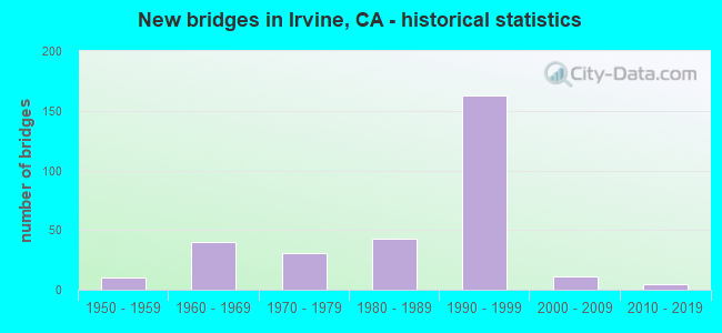
- New bridges - historical statistics
- 11920-1929
- 11930-1939
- 101950-1959
- 401960-1969
- 311970-1979
- 431980-1989
- 1631990-1999
- 112000-2009
- 52010-2019
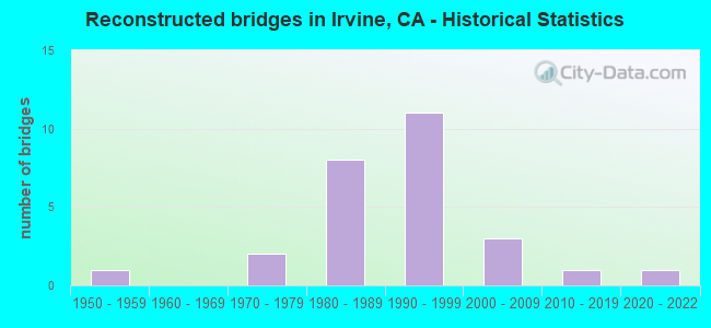
- Reconstructed bridges - Historical Statistics
- 11950-1959
- 01960-1969
- 21970-1979
- 81980-1989
- 111990-1999
- 32000-2009
- 12010-2019
- 12020-2022
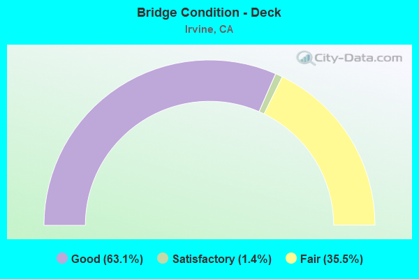
- Bridge Condition - Deck
- 63.1%Good
- 1.4%Satisfactory
- 35.5%Fair
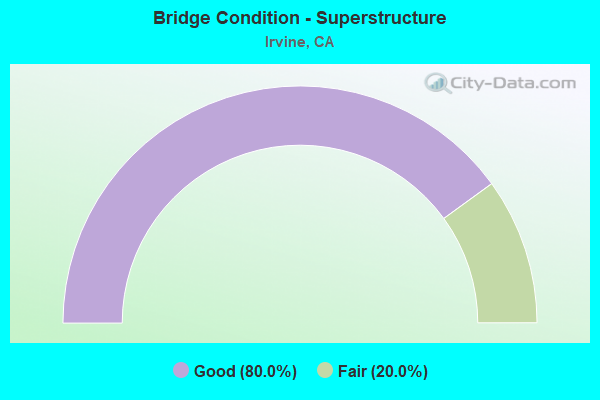
- Bridge Condition - Superstructure
- 80.0%Good
- 20.0%Fair
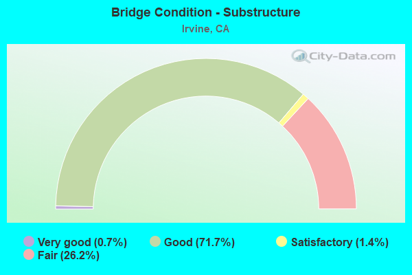
- Bridge Condition - Substructure
- 0.7%Very good
- 71.7%Good
- 1.4%Satisfactory
- 26.2%Fair
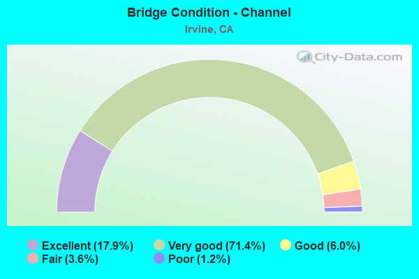
- Bridge Condition - Channel
- 17.9%Excellent
- 71.4%Very good
- 6.0%Good
- 3.6%Fair
- 1.2%Poor
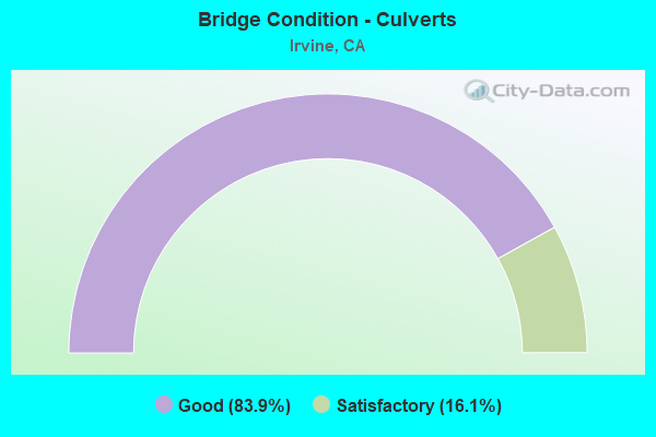
- Bridge Condition - Culverts
- 83.9%Good
- 16.1%Satisfactory
Find on map >> Show street view
Structure Number: 55 0002, Location: 12-ORA-005-R23.58-IRVN (Lat: 33.672344, Lng: -117.755222), Route carried "on" structure: Interstate 5, Year Built: 1992, Status: Open, Structure Length: 8.05m (26.41ft), Average Daily Traffic: 309,000 (year 2019), Truck Traffic: 5%, Average Future Daily Traffic: 315,000 (year 2038), Design Load: HS 20+Mod, Features Intersected: BNSF RY,AMTRAK,METROLINK
Minimum Vertical Clearance: 30+ m (98+ ft), Kilometerpoint: 23.580, Lanes on structure: 14, Lanes under structure: 2, Base Highway Network: Yes (, Subroute: 1), Owner: State Highway Agency, Approaching Roadway Width: 67.1m (220.1ft), Skew: 35 degrees, Material/Design: Prestressed concrete continuous, Design/Construction: Box Beam or Girders - Multiple, Number Of Spans In Main Unit: 2, Length of Maximum Span: 45.1m (148.0ft), Curb-To-Curb Width: 67.1m (220.1ft), Out-to-Out Width: 68.7m (225.4ft)
Condition: Deck: Good, Superstructure: Good, Substructure: Good, Operating Rating: 54.1 metric tons, Method Used To Determine Operating Rating: Assigned rating based on Load Factor Design (LFD) reported in metric tons, Inventory Rating: 32.4 metric tons, Method Used To Determine Inventory Rating: Assigned rating based on Load Factor Design (LFD) reported in metric tons, Structural Evaluation: Better than present minimum criteria, Deck Geometry: Superior to present desirable criteria, Underclear: Better than present minimum criteria, Approach Roadway Alignment: Equal to present desirable criteria, Designated Inspection Frequency: Every 24 months, Inspection Date: November 2020, Deck Structure Type: Concrete Cast-file-Place
Find on map >> Show street view
Structure Number: 55 0009, Location: 12-ORA-005-22.04-IRVN (Lat: 33.655108, Lng: -117.743122), Route carried "on" structure: Interstate 5, Year Built: 1927, Year Reconstructed: 1985, Status: Open, Structure Length: 1.93m (6.33ft), Average Daily Traffic: 201,000 (year 2019), Truck Traffic: 5%, Average Future Daily Traffic: 240,000 (year 2038), Design Load: H 15, Features Intersected: AGUA CHINON WASH
Minimum Vertical Clearance: 30+ m (98+ ft), Kilometerpoint: 22.040, Lanes on structure: 13, Base Highway Network: Yes (, Subroute: 1), Owner: State Highway Agency, Approaching Roadway Width: 33.8m (110.9ft), Skew: 32 degrees, Material/Design: Concrete continuous, Design/Construction: Culvert, Number Of Spans In Main Unit: 6, Length of Maximum Span: 6.1m (20.0ft)
Condition: Channel: Very good, Culverts: Good, Operating Rating: 40.5 metric tons, Method Used To Determine Operating Rating: Field evaluation and documented engineering judgment, Inventory Rating: 24.3 metric tons, Method Used To Determine Inventory Rating: Field evaluation and documented engineering judgment, Structural Evaluation: Equal to present minimum criteria, Waterway Adequacy: Equal to present desirable criteria, Approach Roadway Alignment: Equal to present desirable criteria, Designated Inspection Frequency: Every 24 months, Inspection Date: August 2021
Find on map >> Show street view
Structure Number: 55 0072, Location: 12-ORA-005-20.49-IRVN (Lat: 33.635208, Lng: -117.727139), Route carried "on" structure: Interstate 5, Year Built: 1958, Year Reconstructed: 1995, Status: Open, Structure Length: 1.81m (5.94ft), Average Daily Traffic: 335,000 (year 2019), Average Future Daily Traffic: 365,220 (year 2038), Features Intersected: SAN DIEGO CREEK
Minimum Vertical Clearance: 30+ m (98+ ft), Kilometerpoint: 20.490, Lanes on structure: 23, Base Highway Network: Yes (, Subroute: 1), Owner: State Highway Agency, Approaching Roadway Width: 69.0m (226.4ft), Skew: 30 degrees, Material/Design: Concrete continuous, Design/Construction: Culvert, Number Of Spans In Main Unit: 5, Length of Maximum Span: 3.6m (11.8ft)
Condition: Channel: Very good, Culverts: Good, Operating Rating: 54.1 metric tons, Method Used To Determine Operating Rating: Field evaluation and documented engineering judgment, Inventory Rating: 32.4 metric tons, Method Used To Determine Inventory Rating: Field evaluation and documented engineering judgment, Structural Evaluation: Better than present minimum criteria, Waterway Adequacy: Equal to present desirable criteria, Approach Roadway Alignment: Equal to present desirable criteria, Designated Inspection Frequency: Every 24 months, Inspection Date: July 2021
Find on map >> Show street view
Structure Number: 55 0191, Location: 12-ORA-005-30.26-TUS (Lat: 33.740831, Lng: -117.833514), Route carried "on" structure: Interstate 5, Year Built: 1955, Year Reconstructed: 1995, Status: Open, Structure Length: 6.28m (20.60ft), Average Daily Traffic: 329,500 (year 2016), Truck Traffic: 5%, Average Future Daily Traffic: 361,973 (year 2038), Design Load: HS 20, Features Intersected: ROUTE 55
Minimum Vertical Clearance: 5.59m (18.34ft), Kilometerpoint: 30.260, Lanes on structure: 12, Lanes under structure: 9, Base Highway Network: Yes (, Subroute: 1), Owner: State Highway Agency, Approaching Roadway Width: 51.8m (169.9ft), Skew: 32 degrees, Material/Design: Concrete continuous, Design/Construction: Box Beam or Girders - Multiple, Number Of Spans In Main Unit: 4, Length of Maximum Span: 19.8m (65.0ft), Curb-To-Curb Width: 51.8m (169.9ft), Out-to-Out Width: 59.9m (196.5ft)
Condition: Deck: Fair, Superstructure: Good, Substructure: Good, Operating Rating: 54.1 metric tons, Method Used To Determine Operating Rating: Assigned rating based on Load Factor Design (LFD) reported in metric tons, Inventory Rating: 32.4 metric tons, Method Used To Determine Inventory Rating: Assigned rating based on Load Factor Design (LFD) reported in metric tons, Structural Evaluation: Better than present minimum criteria, Deck Geometry: Superior to present desirable criteria, Underclear: High priority of corrective action, Approach Roadway Alignment: Equal to present desirable criteria, Designated Inspection Frequency: Every 24 months, Inspection Date: August 2021, Deck Structure Type: Concrete Cast-file-Place
Find on map >> Show street view
Structure Number: 55 0197, Location: 12-ORA-005-R26.59-IRVN (Lat: 33.710167, Lng: -117.781828), Route carried "on" structure: Interstate 5, Year Built: 1979, Year Reconstructed: 1992, Status: Open, Structure Length: 5.33m (17.49ft), Average Daily Traffic: 294,400 (year 2019), Average Future Daily Traffic: 300,967 (year 2038), Design Load: HS 20, Features Intersected: CULVER DR
Minimum Vertical Clearance: 30+ m (98+ ft), Kilometerpoint: 26.590, Lanes on structure: 14, Lanes under structure: 7, Base Highway Network: Yes (, Subroute: 1), Owner: State Highway Agency, Approaching Roadway Width: 73.7m (241.8ft), Skew: 39 degrees, Material/Design: Concrete continuous, Design/Construction: Box Beam or Girders - Multiple, Number Of Spans In Main Unit: 2, Length of Maximum Span: 28.0m (91.9ft), Curb-To-Curb Width: 73.7m (241.8ft), Out-to-Out Width: 75.4m (247.4ft)
Condition: Deck: Good, Superstructure: Fair, Substructure: Good, Operating Rating: 54.1 metric tons, Method Used To Determine Operating Rating: Assigned rating based on Load Factor Design (LFD) reported in metric tons, Inventory Rating: 32.4 metric tons, Method Used To Determine Inventory Rating: Assigned rating based on Load Factor Design (LFD) reported in metric tons, Structural Evaluation: Somewhat better than minimum adequacy, Deck Geometry: Superior to present desirable criteria, Underclear: Equal to present minimum criteria, Approach Roadway Alignment: Equal to present desirable criteria, Designated Inspection Frequency: Every 24 months, Inspection Date: August 2021, Deck Structure Type: Concrete Cast-file-Place
Find on map >> Show street view
Structure Number: 55 0245, Location: 12-ORA-091-4.26-ANA (Lat: 33.853647, Lng: -117.906981), Route carried "on" structure: State highway 91, Year Built: 1959, Year Reconstructed: 2016, Status: Open, Structure Length: 4.13m (13.55ft), Average Daily Traffic: 265,000 (year 2012), Truck Traffic: 6%, Average Future Daily Traffic: 295,000 (year 2040), Design Load: HS 20, Features Intersected: EAST STREET
Minimum Vertical Clearance: 30+ m (98+ ft), Kilometerpoint: 4.260, Lanes on structure: 10, Lanes under structure: 4, Base Highway Network: Yes (, Subroute: 1), Owner: State Highway Agency, Approaching Roadway Width: 42.7m (140.1ft), Skew: 30 degrees, Material/Design: Steel, Design/Construction: Stringer/Multi-beam, Number Of Spans In Main Unit: 4, Length of Maximum Span: 12.8m (42.0ft), Curb-To-Curb Width: 42.7m (140.1ft), Out-to-Out Width: 44.3m (145.3ft)
Condition: Deck: Good, Superstructure: Good, Substructure: Good, Operating Rating: 63.5 metric tons, Method Used To Determine Operating Rating: Load Factor (LF), Inventory Rating: 37.9 metric tons, Method Used To Determine Inventory Rating: Load Factor (LF), Structural Evaluation: Better than present minimum criteria, Deck Geometry: Equal to present minimum criteria, Underclear: Somewhat better than minimum adequacy, Approach Roadway Alignment: Equal to present desirable criteria, Designated Inspection Frequency: Every 24 months, Inspection Date: August 2021, Deck Structure Type: Concrete Cast-file-Place, Wearing Surface/Protective System: Wearing Surface: Integral Concrete
Find on map >> Show street view
Structure Number: 55 0246L, Location: 12-ORA-133-8.34-IRVN (Lat: 33.651208, Lng: -117.761422), Route carried "on" structure: State highway 133, Year Built: 1968, Status: Open, Structure Length: 12.37m (40.58ft), Average Daily Traffic: 20,000 (year 2019), Truck Traffic: 3%, Average Future Daily Traffic: 21,100 (year 2038), Design Load: HS 20, Features Intersected: INTERSTATE 405 & RAMPS
Minimum Vertical Clearance: 30+ m (98+ ft), Kilometerpoint: 8.340, Lanes on structure: 4, Lanes under structure: 13, Base Highway Network: Yes (Inventory Route: 1, Subroute: 1), Owner: State Highway Agency, Approaching Roadway Width: 19.2m (63.0ft), Material/Design: Concrete continuous, Design/Construction: Box Beam or Girders - Multiple, Number Of Spans In Main Unit: 4, Length of Maximum Span: 32.9m (107.9ft), Curb-To-Curb Width: 19.2m (63.0ft), Out-to-Out Width: 19.8m (65.0ft)
Condition: Deck: Fair, Superstructure: Fair, Substructure: Good, Operating Rating: 50.2 metric tons, Method Used To Determine Operating Rating: Load and Resistance Factor Rating (LRFR) rating reported by rating factor(RF) method using HL-93 loadings, Inventory Rating: 38.9 metric tons, Method Used To Determine Inventory Rating: Load and Resistance Factor Rating (LRFR) rating reported by rating factor(RF) method using HL-93 loadings, Structural Evaluation: Somewhat better than minimum adequacy, Deck Geometry: Somewhat better than minimum adequacy, Underclear: Somewhat better than minimum adequacy, Approach Roadway Alignment: Equal to present desirable criteria, Designated Inspection Frequency: Every 24 months, Inspection Date: November 2020, Deck Structure Type: Concrete Cast-file-Place
Find on map >> Show street view
Structure Number: 55 0246R, Location: 12-ORA-133-8.34-IRVN (Lat: 33.651136, Lng: -117.760950), Route carried "on" structure: State highway 133, Year Built: 1968, Status: Open, Structure Length: 11.89m (39.01ft), Average Daily Traffic: 20,000 (year 2019), Truck Traffic: 3%, Average Future Daily Traffic: 21,100 (year 2038), Design Load: HS 20, Features Intersected: INTERSTATE 405 & RAMPS
Minimum Vertical Clearance: 30+ m (98+ ft), Kilometerpoint: 8.340, Lanes on structure: 3, Lanes under structure: 14, Base Highway Network: Yes (Inventory Route: 1, Subroute: 1), Owner: State Highway Agency, Approaching Roadway Width: 15.4m (50.5ft), Material/Design: Concrete continuous, Design/Construction: Box Beam or Girders - Multiple, Number Of Spans In Main Unit: 4, Length of Maximum Span: 34.4m (112.9ft), Curb-To-Curb Width: 15.4m (50.5ft), Out-to-Out Width: 16.0m (52.5ft)
Condition: Deck: Good, Superstructure: Fair, Substructure: Good, Operating Rating: 81.3 metric tons, Method Used To Determine Operating Rating: Load Factor (LF), Inventory Rating: 48.6 metric tons, Method Used To Determine Inventory Rating: Load Factor (LF), Structural Evaluation: Somewhat better than minimum adequacy, Deck Geometry: Somewhat better than minimum adequacy, Underclear: Somewhat better than minimum adequacy, Approach Roadway Alignment: Equal to present desirable criteria, Designated Inspection Frequency: Every 24 months, Inspection Date: November 2020, Deck Structure Type: Concrete Cast-file-Place
Find on map >> Show street view
Structure Number: 55 0247, Location: 12-ORA-405-2.20-IRVN (Lat: 33.652206, Lng: -117.767597), Route carried "on" structure: City street M281, Year Built: 1968, Status: Open, Structure Length: 13.01m (42.68ft), Average Daily Traffic: 10,000 (year 2011), Truck Traffic: 3%, Average Future Daily Traffic: 11,797 (year 2038), Design Load: HS 20, Features Intersected: I 405, Facility Carried by Structure: LAGUNA CANYON ROAD
Minimum Vertical Clearance: 30+ m (98+ ft), Kilometerpoint: 0.000, Lanes on structure: 2, Lanes under structure: 12, Owner: State Highway Agency, Approaching Roadway Width: 8.5m (27.9ft), Skew: 3 degrees, Material/Design: Prestressed concrete continuous, Design/Construction: Box Beam or Girders - Multiple, Number Of Spans In Main Unit: 4, Length of Maximum Span: 45.7m (149.9ft), Curb or Sidewalk Widths: Left: 0.6m (2.0ft), Right: 1.5m (4.9ft), Curb-To-Curb Width: 8.5m (27.9ft), Out-to-Out Width: 11.3m (37.1ft)
Condition: Deck: Good, Superstructure: Good, Substructure: Good, Operating Rating: 54.1 metric tons, Method Used To Determine Operating Rating: Assigned rating based on Load Factor Design (LFD) reported in metric tons, Inventory Rating: 32.4 metric tons, Method Used To Determine Inventory Rating: Assigned rating based on Load Factor Design (LFD) reported in metric tons, Structural Evaluation: Better than present minimum criteria, Deck Geometry: Meets minimum limits, Underclear: High priority of corrective action, Approach Roadway Alignment: Equal to present desirable criteria, Designated Inspection Frequency: Every 24 months, Inspection Date: March 2021, Deck Structure Type: Concrete Cast-file-Place
Find on map >> Show street view
Structure Number: 55 0248, Location: 12-ORA-405-3.95-IRVN (Lat: 33.663022, Lng: -117.795056), Route carried "on" structure: City street M026, Year Built: 1968, Year Reconstructed: 2006, Status: Open, Structure Length: 10.73m (35.20ft), Average Daily Traffic: 15,000 (year 2011), Truck Traffic: 3%, Average Future Daily Traffic: 17,694 (year 2038), Design Load: HS 20, Features Intersected: INTERSTATE 405, Facility Carried by Structure: UNIVERSITY DR
Minimum Vertical Clearance: 30+ m (98+ ft), Kilometerpoint: 0.000, Lanes on structure: 6, Lanes under structure: 12, Owner: State Highway Agency, Approaching Roadway Width: 27.6m (90.6ft), Skew: 23 degrees, Material/Design: Prestressed concrete continuous, Design/Construction: Box Beam or Girders - Multiple, Number Of Spans In Main Unit: 2, Length of Maximum Span: 53.5m (175.5ft), Curb or Sidewalk Widths: Left: 1.5m (4.9ft), Right: 1.5m (4.9ft), Curb-To-Curb Width: 27.6m (90.6ft), Out-to-Out Width: 31.2m (102.4ft)
Condition: Deck: Fair, Superstructure: Good, Substructure: Good, Operating Rating: 54.1 metric tons, Method Used To Determine Operating Rating: Assigned rating based on Load Factor Design (LFD) reported in metric tons, Inventory Rating: 32.4 metric tons, Method Used To Determine Inventory Rating: Assigned rating based on Load Factor Design (LFD) reported in metric tons, Structural Evaluation: Better than present minimum criteria, Deck Geometry: Better than present minimum criteria, Underclear: High priority of corrective action, Approach Roadway Alignment: Equal to present desirable criteria, Designated Inspection Frequency: Every 24 months, Inspection Date: March 2021, Deck Structure Type: Concrete Cast-file-Place
Find on map >> Show street view
Structure Number: 55 0249, Location: 12-ORA-405-5.62-IRVN (Lat: 33.669161, Lng: -117.822867), Route carried "on" structure: City street M210, Year Built: 1968, Year Reconstructed: 1989, Status: Open, Structure Length: 7.99m (26.21ft), Average Daily Traffic: 20,000 (year 2011), Truck Traffic: 3%, Average Future Daily Traffic: 23,592 (year 2038), Design Load: HS 20, Features Intersected: I 405, Facility Carried by Structure: CULVER DR
Minimum Vertical Clearance: 30+ m (98+ ft), Kilometerpoint: 0.000, Lanes on structure: 6, Lanes under structure: 12, Owner: State Highway Agency, Approaching Roadway Width: 27.4m (89.9ft), Skew: 21 degrees, Material/Design: Prestressed concrete continuous, Design/Construction: Box Beam or Girders - Multiple, Number Of Spans In Main Unit: 2, Length of Maximum Span: 39.6m (129.9ft), Curb or Sidewalk Widths: Left: 1.5m (4.9ft), Right: 1.5m (4.9ft), Curb-To-Curb Width: 27.4m (89.9ft), Out-to-Out Width: 31.1m (102.0ft)
Condition: Deck: Good, Superstructure: Good, Substructure: Fair, Operating Rating: 54.1 metric tons, Method Used To Determine Operating Rating: Assigned rating based on Load Factor Design (LFD) reported in metric tons, Inventory Rating: 32.4 metric tons, Method Used To Determine Inventory Rating: Assigned rating based on Load Factor Design (LFD) reported in metric tons, Structural Evaluation: Somewhat better than minimum adequacy, Deck Geometry: Better than present minimum criteria, Underclear: High priority of corrective action, Approach Roadway Alignment: Equal to present desirable criteria, Designated Inspection Frequency: Every 24 months, Inspection Date: March 2021, Deck Structure Type: Concrete Cast-file-Place
Find on map >> Show street view
Structure Number: 55 0285, Location: 12-ORA-405-6.41-IRVN (Lat: 33.674042, Lng: -117.835528), Route carried "on" structure: Interstate 405, Year Built: 1968, Year Reconstructed: 1990, Status: Open, Structure Length: 8.11m (26.61ft), Average Daily Traffic: 266,000 (year 2011), Truck Traffic: 5%, Average Future Daily Traffic: 264,000 (year 2038), Design Load: HS 20, Features Intersected: SAN DIEGO CREEK CHANNEL
Minimum Vertical Clearance: 30+ m (98+ ft), Kilometerpoint: 6.410, Lanes on structure: 13, Base Highway Network: Yes (Inventory Route: 4, Subroute: 1), Owner: State Highway Agency, Approaching Roadway Width: 59.5m (195.2ft), Skew: 31 degrees, Material/Design: Concrete continuous, Design/Construction: Box Beam or Girders - Multiple, Number Of Spans In Main Unit: 3, Length of Maximum Span: 27.4m (89.9ft), Curb-To-Curb Width: 59.5m (195.2ft), Out-to-Out Width: 60.6m (198.8ft)
Condition: Deck: Good, Superstructure: Good, Substructure: Fair, Channel: Very good, Operating Rating: 54.1 metric tons, Method Used To Determine Operating Rating: Assigned rating based on Load Factor Design (LFD) reported in metric tons, Inventory Rating: 32.4 metric tons, Method Used To Determine Inventory Rating: Assigned rating based on Load Factor Design (LFD) reported in metric tons, Structural Evaluation: Somewhat better than minimum adequacy, Deck Geometry: Superior to present desirable criteria, Waterway Adequacy: Equal to present desirable criteria, Approach Roadway Alignment: Equal to present desirable criteria, Designated Inspection Frequency: Every 24 months, Inspection Date: March 2021, Deck Structure Type: Concrete Cast-file-Place
Find on map >> Show street view
Structure Number: 55 0288, Location: 12-ORA-005-20.97-IRVN (Lat: 33.640847, Lng: -117.732022), Route carried "on" structure: Interstate 5, Year Built: 1958, Year Reconstructed: 1996, Status: Open, Structure Length: 33.25m (109.09ft), Average Daily Traffic: 297,000 (year 2019), Truck Traffic: 4%, Average Future Daily Traffic: 358,000 (year 2038), Features Intersected: SERRANO CREEK
Minimum Vertical Clearance: 30+ m (98+ ft), Kilometerpoint: 20.970, Lanes on structure: 13, Base Highway Network: Yes (, Subroute: 1), Owner: State Highway Agency, Approaching Roadway Width: 61.0m (200.1ft), Skew: 30 degrees, Material/Design: Concrete, Design/Construction: Culvert, Number Of Spans In Main Unit: 1, Length of Maximum Span: 8.9m (29.2ft)
Condition: Channel: Good, Culverts: Good, Operating Rating: 54.1 metric tons, Method Used To Determine Operating Rating: Field evaluation and documented engineering judgment, Inventory Rating: 32.4 metric tons, Method Used To Determine Inventory Rating: Field evaluation and documented engineering judgment, Structural Evaluation: Better than present minimum criteria, Waterway Adequacy: Equal to present desirable criteria, Approach Roadway Alignment: Equal to present desirable criteria, Designated Inspection Frequency: Every 24 months, Inspection Date: July 2021
Find on map >> Show street view
Structure Number: 55 0290L, Location: 12-ORA-133-8.59-IRVN (Lat: 33.654539, Lng: -117.759733), Route carried "on" structure: State highway 133, Year Built: 1968, Year Reconstructed: 1999, Status: Open, Structure Length: 4.60m (15.09ft), Average Daily Traffic: 20,000 (year 2019), Truck Traffic: 5%, Average Future Daily Traffic: 22,800 (year 2038), Design Load: HS 20+Mod, Features Intersected: SAN DIEGO CREEK
Minimum Vertical Clearance: 30+ m (98+ ft), Kilometerpoint: 8.590, Lanes on structure: 2, Base Highway Network: Yes (Inventory Route: 1, Subroute: 1), Owner: State Highway Agency, Approaching Roadway Width: 13.3m (43.6ft), Material/Design: Concrete continuous, Design/Construction: Slab, Number Of Spans In Main Unit: 5, Length of Maximum Span: 9.1m (29.9ft), Curb-To-Curb Width: 13.3m (43.6ft), Out-to-Out Width: 14.3m (46.9ft)
Condition: Deck: Good, Superstructure: Good, Substructure: Fair, Channel: Good, Operating Rating: 54.1 metric tons, Method Used To Determine Operating Rating: Load Factor (LF), Inventory Rating: 32.4 metric tons, Method Used To Determine Inventory Rating: Load Factor (LF), Structural Evaluation: Somewhat better than minimum adequacy, Deck Geometry: Superior to present desirable criteria, Waterway Adequacy: Better than present minimum criteria, Approach Roadway Alignment: Equal to present desirable criteria, Designated Inspection Frequency: Every 24 months, Inspection Date: November 2020, Deck Structure Type: Concrete Cast-file-Place
Find on map >> Show street view
Structure Number: 55 0290R, Location: 12-ORA-133-8.59-IRVN (Lat: 33.654372, Lng: -117.759344), Route carried "on" structure: State highway 133, Year Built: 1958, Year Reconstructed: 1999, Status: Open, Structure Length: 4.60m (15.09ft), Average Daily Traffic: 20,000 (year 2019), Truck Traffic: 5%, Average Future Daily Traffic: 22,800 (year 2038), Design Load: HS 20+Mod, Features Intersected: SAN DIEGO CREEK
Minimum Vertical Clearance: 30+ m (98+ ft), Kilometerpoint: 8.590, Lanes on structure: 3, Base Highway Network: Yes (Inventory Route: 1, Subroute: 1), Owner: State Highway Agency, Approaching Roadway Width: 17.9m (58.7ft), Material/Design: Concrete continuous, Design/Construction: Slab, Number Of Spans In Main Unit: 5, Length of Maximum Span: 9.1m (29.9ft), Curb-To-Curb Width: 17.9m (58.7ft), Out-to-Out Width: 18.9m (62.0ft)
Condition: Deck: Fair, Superstructure: Fair, Substructure: Fair, Channel: Good, Operating Rating: 54.1 metric tons, Method Used To Determine Operating Rating: Load Factor (LF), Inventory Rating: 32.4 metric tons, Method Used To Determine Inventory Rating: Load Factor (LF), Structural Evaluation: Somewhat better than minimum adequacy, Deck Geometry: Better than present minimum criteria, Waterway Adequacy: Better than present minimum criteria, Approach Roadway Alignment: Equal to present desirable criteria, Designated Inspection Frequency: Every 24 months, Inspection Date: November 2020, Deck Structure Type: Concrete Cast-file-Place
Find on map >> Show street view
Structure Number: 55 0440R, Location: 12-ORA-405-7.80-IRVN (Lat: 33.682206, Lng: -117.857178), Route carried "on" structure: City street M034, Year Built: 1996, Status: Open, Structure Length: 10.97m (35.99ft), Average Daily Traffic: 12,000 (year 2011), Truck Traffic: 3%, Average Future Daily Traffic: 14,156 (year 2038), Design Load: HS 20+Mod, Features Intersected: INTERSTATE 405, Facility Carried by Structure: MACARTHUR BLVD
Minimum Vertical Clearance: 30+ m (98+ ft), Kilometerpoint: 0.000, Lanes on structure: 6, Lanes under structure: 15, Owner: State Highway Agency, Approaching Roadway Width: 21.9m (71.9ft), Material/Design: Prestressed concrete continuous, Design/Construction: Box Beam or Girders - Multiple, Number Of Spans In Main Unit: 4, Length of Maximum Span: 35.4m (116.1ft), Curb or Sidewalk Widths: Left: 0.0m, Right: 1.5m (4.9ft), Curb-To-Curb Width: 21.9m (71.9ft), Out-to-Out Width: 24.3m (79.7ft)
Condition: Deck: Fair, Superstructure: Good, Substructure: Fair, Operating Rating: 54.1 metric tons, Method Used To Determine Operating Rating: Assigned rating based on Load Factor Design (LFD) reported in metric tons, Inventory Rating: 32.4 metric tons, Method Used To Determine Inventory Rating: Assigned rating based on Load Factor Design (LFD) reported in metric tons, Structural Evaluation: Somewhat better than minimum adequacy, Deck Geometry: High priority of corrective action, Underclear: High priority of corrective action, Approach Roadway Alignment: Equal to present desirable criteria, Designated Inspection Frequency: Every 24 months, Inspection Date: August 2021, Deck Structure Type: Concrete Cast-file-Place, Wearing Surface/Protective System: Wearing Surface: Monolithic Concrete
Find on map >> Show street view
Structure Number: 55 0442, Location: 12-ORA-405-0.95-IRVN (Lat: 33.647450, Lng: -117.746553), Route carried "on" structure: City street W461, Year Built: 1968, Year Reconstructed: 1988, Status: Open, Structure Length: 13.81m (45.31ft), Average Daily Traffic: 10,000 (year 2011), Truck Traffic: 3%, Average Future Daily Traffic: 11,797 (year 2038), Design Load: HS 20+Mod, Features Intersected: INTERSTATE 405, Facility Carried by Structure: IRVINE CENTER DR
Minimum Vertical Clearance: 30+ m (98+ ft), Kilometerpoint: 0.000, Lanes on structure: 7, Lanes under structure: 11, Owner: State Highway Agency, Approaching Roadway Width: 29.9m (98.1ft), Skew: 14 degrees, Material/Design: Prestressed concrete continuous, Design/Construction: Box Beam or Girders - Multiple, Number Of Spans In Main Unit: 4, Length of Maximum Span: 52.7m (172.9ft), Curb or Sidewalk Widths: Left: 1.5m (4.9ft), Right: 1.5m (4.9ft), Curb-To-Curb Width: 29.9m (98.1ft), Out-to-Out Width: 33.5m (109.9ft)
Condition: Deck: Good, Superstructure: Good, Substructure: Good, Operating Rating: 54.1 metric tons, Method Used To Determine Operating Rating: Assigned rating based on Load Factor Design (LFD) reported in metric tons, Inventory Rating: 32.4 metric tons, Method Used To Determine Inventory Rating: Assigned rating based on Load Factor Design (LFD) reported in metric tons, Structural Evaluation: Better than present minimum criteria, Deck Geometry: Equal to present minimum criteria, Underclear: High priority of corrective action, Approach Roadway Alignment: Better than present minimum criteria, Designated Inspection Frequency: Every 24 months, Inspection Date: March 2021, Deck Structure Type: Concrete Cast-file-Place
Find on map >> Show street view
Structure Number: 55 0443, Location: 12-ORA-405-2.88-IRVN (Lat: 33.657333, Lng: -117.778203), Route carried "on" structure: City street W463, Year Built: 1968, Status: Open, Structure Length: 9.51m (31.20ft), Average Daily Traffic: 15,000 (year 2011), Truck Traffic: 3%, Average Future Daily Traffic: 17,694 (year 2038), Design Load: HS 20, Features Intersected: INTERSTATE 405, Facility Carried by Structure: SAND CANYON AVE
Minimum Vertical Clearance: 30+ m (98+ ft), Kilometerpoint: 0.000, Lanes on structure: 4, Lanes under structure: 14, Owner: State Highway Agency, Approaching Roadway Width: 15.8m (51.8ft), Material/Design: Prestressed concrete continuous, Design/Construction: Box Beam or Girders - Multiple, Number Of Spans In Main Unit: 2, Length of Maximum Span: 47.5m (155.8ft), Curb or Sidewalk Widths: Left: 1.5m (4.9ft), Right: 1.5m (4.9ft), Curb-To-Curb Width: 15.8m (51.8ft), Out-to-Out Width: 19.5m (64.0ft)
Condition: Deck: Good, Superstructure: Fair, Substructure: Fair, Operating Rating: 54.1 metric tons, Method Used To Determine Operating Rating: Assigned rating based on Load Factor Design (LFD) reported in metric tons, Inventory Rating: 32.4 metric tons, Method Used To Determine Inventory Rating: Assigned rating based on Load Factor Design (LFD) reported in metric tons, Structural Evaluation: Somewhat better than minimum adequacy, Deck Geometry: Meets minimum limits, Underclear: High priority of corrective action, Approach Roadway Alignment: Equal to present desirable criteria, Designated Inspection Frequency: Every 24 months, Inspection Date: March 2021, Deck Structure Type: Concrete Cast-file-Place
Find on map >> Show street view
Structure Number: 55 0451, Location: 12-ORA-405-1.50-IRVN (Lat: 33.650997, Lng: -117.756050), Route carried "on" structure: Interstate 405, Year Built: 1968, Year Reconstructed: 1990, Status: Open, Structure Length: 3.74m (12.27ft), Average Daily Traffic: 205,000 (year 2011), Truck Traffic: 5%, Average Future Daily Traffic: 229,000 (year 2038), Design Load: HS 20, Features Intersected: SAN DIEGO CREEK CHANNEL
Minimum Vertical Clearance: 30+ m (98+ ft), Kilometerpoint: 1.500, Lanes on structure: 12, Base Highway Network: Yes (Inventory Route: 4, Subroute: 1), Owner: State Highway Agency, Approaching Roadway Width: 71.0m (232.9ft), Skew: 34 degrees, Material/Design: Concrete continuous, Design/Construction: Girder and Floorbeam System, Number Of Spans In Main Unit: 2, Length of Maximum Span: 18.3m (60.0ft), Curb-To-Curb Width: 71.0m (232.9ft), Out-to-Out Width: 72.2m (236.9ft)
Condition: Deck: Good, Superstructure: Good, Substructure: Good, Channel: Very good, Operating Rating: 54.1 metric tons, Method Used To Determine Operating Rating: Assigned rating based on Load Factor Design (LFD) reported in metric tons, Inventory Rating: 32.4 metric tons, Method Used To Determine Inventory Rating: Assigned rating based on Load Factor Design (LFD) reported in metric tons, Structural Evaluation: Better than present minimum criteria, Deck Geometry: Superior to present desirable criteria, Waterway Adequacy: Equal to present desirable criteria, Approach Roadway Alignment: Equal to present desirable criteria, Designated Inspection Frequency: Every 24 months, Inspection Date: March 2021, Deck Structure Type: Concrete Cast-file-Place
Find on map >> Show street view
Structure Number: 55 0452G, Location: 12-ORA-133-8.34-IRVN (Lat: 33.650992, Lng: -117.759456), Route carried "on" structure: Ramp State highway 133, Year Built: 1968, Status: Open, Structure Length: 10.55m (34.61ft), Average Daily Traffic: 20,025 (year 2015), Truck Traffic: 3%, Average Future Daily Traffic: 21,026 (year 2037), Design Load: HS 20+Mod, Features Intersected: INTERSTATE 405 & RAMP
Minimum Vertical Clearance: 30+ m (98+ ft), Kilometerpoint: 8.340, Lanes on structure: 1, Lanes under structure: 12, Owner: State Highway Agency, Approaching Roadway Width: 8.5m (27.9ft), Skew: 1 degrees, Material/Design: Concrete continuous, Design/Construction: Box Beam or Girders - Multiple, Number Of Spans In Main Unit: 4, Length of Maximum Span: 35.4m (116.1ft), Curb or Sidewalk Widths: Left: 0.6m (2.0ft), Right: 0.6m (2.0ft), Curb-To-Curb Width: 8.5m (27.9ft), Out-to-Out Width: 10.4m (34.1ft)
Condition: Deck: Good, Superstructure: Fair, Substructure: Fair, Operating Rating: 35.6 metric tons, Method Used To Determine Operating Rating: Load and Resistance Factor Rating (LRFR) rating reported by rating factor(RF) method using HL-93 loadings, Inventory Rating: 27.5 metric tons, Method Used To Determine Inventory Rating: Load and Resistance Factor Rating (LRFR) rating reported by rating factor(RF) method using HL-93 loadings, Structural Evaluation: Somewhat better than minimum adequacy, Deck Geometry: Superior to present desirable criteria, Underclear: High priority of corrective action, Approach Roadway Alignment: Equal to present desirable criteria, Designated Inspection Frequency: Every 24 months, Inspection Date: November 2020, Deck Structure Type: Concrete Cast-file-Place
Find on map >> Show street view
Structure Number: 55 0453G, Location: 12-ORA-133-8.47-IRVN (Lat: 33.653147, Lng: -117.760858), Route carried "on" structure: Ramp State highway 133, Year Built: 1968, Status: Open, Structure Length: 7.56m (24.80ft), Average Daily Traffic: 6,063 (year 2014), Truck Traffic: 3%, Average Future Daily Traffic: 7,206 (year 2037), Design Load: HS 20, Features Intersected: STATE ROUTE 133
Minimum Vertical Clearance: 30+ m (98+ ft), Kilometerpoint: 8.470, Lanes on structure: 1, Lanes under structure: 6, Owner: State Highway Agency, Approaching Roadway Width: 8.5m (27.9ft), Material/Design: Concrete continuous, Design/Construction: Box Beam or Girders - Multiple, Number Of Spans In Main Unit: 2, Length of Maximum Span: 37.5m (123.0ft), Curb or Sidewalk Widths: Left: 0.6m (2.0ft), Right: 0.6m (2.0ft), Curb-To-Curb Width: 8.5m (27.9ft), Out-to-Out Width: 10.4m (34.1ft)
Condition: Deck: Good, Superstructure: Fair, Substructure: Good, Operating Rating: 46.3 metric tons, Method Used To Determine Operating Rating: Load and Resistance Factor Rating (LRFR) rating reported by rating factor(RF) method using HL-93 loadings, Inventory Rating: 35.6 metric tons, Method Used To Determine Inventory Rating: Load and Resistance Factor Rating (LRFR) rating reported by rating factor(RF) method using HL-93 loadings, Structural Evaluation: Somewhat better than minimum adequacy, Deck Geometry: Superior to present desirable criteria, Underclear: High priority of corrective action, Approach Roadway Alignment: Equal to present desirable criteria, Designated Inspection Frequency: Every 24 months, Inspection Date: November 2020, Deck Structure Type: Concrete Cast-file-Place
Find on map >> Show street view
Structure Number: 55 0455G, Location: 12-ORA-005-21.31-IRVN (Lat: 33.644617, Lng: -117.734619), Route carried "on" structure: Ramp Interstate 5, Year Built: 1968, Status: Open, Structure Length: 12.56m (41.21ft), Average Daily Traffic: 52,000 (year 2019), Truck Traffic: 4%, Average Future Daily Traffic: 60,933 (year 2038), Design Load: HS 20, Features Intersected: INTERSTATE 5
Minimum Vertical Clearance: 30+ m (98+ ft), Kilometerpoint: 21.310, Lanes on structure: 3, Lanes under structure: 8, Base Highway Network: Yes (, Subroute: 1), Owner: State Highway Agency, Approaching Roadway Width: 15.5m (50.9ft), Skew: 9 degrees, Material/Design: Steel, Design/Construction: Stringer/Multi-beam, Number Of Spans In Main Unit: 4, Length of Maximum Span: 46.0m (150.9ft), Curb-To-Curb Width: 15.5m (50.9ft), Out-to-Out Width: 16.2m (53.1ft)
Condition: Deck: Fair, Superstructure: Good, Substructure: Fair, Operating Rating: 54.1 metric tons, Method Used To Determine Operating Rating: Assigned rating based on Load Factor Design (LFD) reported in metric tons, Inventory Rating: 32.4 metric tons, Method Used To Determine Inventory Rating: Assigned rating based on Load Factor Design (LFD) reported in metric tons, Structural Evaluation: Somewhat better than minimum adequacy, Deck Geometry: Superior to present desirable criteria, Underclear: High priority of corrective action, Approach Roadway Alignment: Meets minimum limits, Designated Inspection Frequency: Every 24 months, Other Special Inspection Frequency: Every 48 months, Inspection Date: August 2021, Other Special Inspection Date: December 2019, Deck Structure Type: Concrete Cast-file-Place
Find on map >> Show street view
Structure Number: 55 0508, Location: 12-ORA-133-M9.23-IRVN (Lat: 33.663014, Lng: -117.755239), Route carried "on" structure: County highway , Year Built: 1970, Year Reconstructed: 1989, Status: Open, Structure Length: 7.25m (23.79ft), Average Daily Traffic: 20,000 (year 2017), Truck Traffic: 3%, Average Future Daily Traffic: 20,529 (year 2043), Design Load: HS 20+Mod, Features Intersected: STATE ROUTE 133, Facility Carried by Structure: IRVINE CENTER DR
Minimum Vertical Clearance: 30+ m (98+ ft), Kilometerpoint: 0.000, Lanes on structure: 4, Lanes under structure: 8, Owner: State Highway Agency, Approaching Roadway Width: 26.8m (87.9ft), Skew: 1 degrees, Material/Design: Concrete continuous, Design/Construction: Box Beam or Girders - Multiple, Number Of Spans In Main Unit: 2, Length of Maximum Span: 36.0m (118.1ft), Curb or Sidewalk Widths: Left: 1.5m (4.9ft), Right: 1.5m (4.9ft), Curb-To-Curb Width: 26.8m (87.9ft), Out-to-Out Width: 39.0m (128.0ft)
Condition: Deck: Fair, Superstructure: Good, Substructure: Good, Operating Rating: 54.1 metric tons, Method Used To Determine Operating Rating: Assigned rating based on Load Factor Design (LFD) reported in metric tons, Inventory Rating: 32.4 metric tons, Method Used To Determine Inventory Rating: Assigned rating based on Load Factor Design (LFD) reported in metric tons, Structural Evaluation: Better than present minimum criteria, Deck Geometry: Superior to present desirable criteria, Underclear: High priority of corrective action, Approach Roadway Alignment: Equal to present desirable criteria, Designated Inspection Frequency: Every 24 months, Inspection Date: January 2021, Deck Structure Type: Concrete Cast-file-Place, Wearing Surface/Protective System: Wearing Surface: Monolithic Concrete
Find on map >> Show street view
Structure Number: 55 0521, Location: 12-ORA-405-4.24-IRVN (Lat: 33.664400, Lng: -117.799914), Route carried "on" structure: Interstate 405, Year Built: 1968, Status: Open, Structure Length: 1.22m (4.00ft), Average Daily Traffic: 224,000 (year 2011), Truck Traffic: 5%, Average Future Daily Traffic: 264,000 (year 2038), Design Load: HS 20, Features Intersected: SAN JOAQUIN CHANNEL
Minimum Vertical Clearance: 30+ m (98+ ft), Kilometerpoint: 4.240, Lanes on structure: 12, Base Highway Network: Yes (Inventory Route: 4, Subroute: 1), Owner: State Highway Agency, Approaching Roadway Width: 56.4m (185.0ft), Skew: 3 degrees, Material/Design: Concrete, Design/Construction: Culvert, Number Of Spans In Main Unit: 3, Length of Maximum Span: 3.7m (12.1ft), Curb-To-Curb Width: 56.4m (185.0ft), Out-to-Out Width: 57.4m (188.3ft)
Condition: Channel: Very good, Culverts: Good, Operating Rating: 54.1 metric tons, Method Used To Determine Operating Rating: Assigned rating based on Load Factor Design (LFD) reported in metric tons, Inventory Rating: 32.4 metric tons, Method Used To Determine Inventory Rating: Assigned rating based on Load Factor Design (LFD) reported in metric tons, Structural Evaluation: Better than present minimum criteria, Deck Geometry: Superior to present desirable criteria, Waterway Adequacy: Equal to present desirable criteria, Approach Roadway Alignment: Equal to present desirable criteria, Designated Inspection Frequency: Every 24 months, Inspection Date: March 2021
Find on map >> Show street view
Structure Number: 55 0522, Location: 12-ORA-405-6.13-IRVN (Lat: 33.672433, Lng: -117.830714), Route carried "on" structure: Interstate 405, Year Built: 1968, Status: Open, Structure Length: 1.19m (3.90ft), Average Daily Traffic: 266,000 (year 2011), Truck Traffic: 5%, Average Future Daily Traffic: 264,000 (year 2038), Design Load: HS 20, Features Intersected: SAN JOAQUIN CHANNEL
Minimum Vertical Clearance: 30+ m (98+ ft), Kilometerpoint: 6.130, Lanes on structure: 12, Base Highway Network: Yes (Inventory Route: 4, Subroute: 1), Owner: State Highway Agency, Approaching Roadway Width: 48.8m (160.1ft), Skew: 32 degrees, Material/Design: Concrete, Design/Construction: Culvert, Number Of Spans In Main Unit: 3, Length of Maximum Span: 4.0m (13.1ft), Curb-To-Curb Width: 48.8m (160.1ft), Out-to-Out Width: 49.8m (163.4ft)
Condition: Channel: Very good, Culverts: Good, Operating Rating: 54.1 metric tons, Method Used To Determine Operating Rating: Assigned rating based on Load Factor Design (LFD) reported in metric tons, Inventory Rating: 32.4 metric tons, Method Used To Determine Inventory Rating: Assigned rating based on Load Factor Design (LFD) reported in metric tons, Structural Evaluation: Better than present minimum criteria, Deck Geometry: Somewhat better than minimum adequacy, Waterway Adequacy: Equal to present desirable criteria, Approach Roadway Alignment: Equal to present desirable criteria, Designated Inspection Frequency: Every 24 months, Inspection Date: March 2021
Find on map >> Show street view
Structure Number: 55 0523S, Location: 12-ORA-405-6.86-IRVN (Lat: 33.676433, Lng: -117.841081), Route carried "on" structure: Ramp Interstate 405, Year Built: 1968, Status: Open, Structure Length: 1.19m (3.90ft), Average Daily Traffic: 240,000 (year 2011), Truck Traffic: 5%, Average Future Daily Traffic: 262,618 (year 2038), Design Load: HS 20, Features Intersected: LANE CHANNEL
Minimum Vertical Clearance: 30+ m (98+ ft), Kilometerpoint: 6.860, Lanes on structure: 3, Base Highway Network: Yes (Inventory Route: 4, Subroute: 1), Owner: State Highway Agency, Approaching Roadway Width: 12.2m (40.0ft), Skew: 5 degrees, Material/Design: Concrete, Design/Construction: Culvert, Number Of Spans In Main Unit: 3, Length of Maximum Span: 3.7m (12.1ft), Curb-To-Curb Width: 12.2m (40.0ft), Out-to-Out Width: 13.2m (43.3ft)
Condition: Channel: Very good, Culverts: Good, Operating Rating: 54.1 metric tons, Method Used To Determine Operating Rating: Assigned rating based on Load Factor Design (LFD) reported in metric tons, Inventory Rating: 32.4 metric tons, Method Used To Determine Inventory Rating: Assigned rating based on Load Factor Design (LFD) reported in metric tons, Structural Evaluation: Better than present minimum criteria, Deck Geometry: High priority of corrective action, Waterway Adequacy: Equal to present desirable criteria, Approach Roadway Alignment: Equal to present desirable criteria, Designated Inspection Frequency: Every 24 months, Inspection Date: March 2021
Find on map >> Show street view
Structure Number: 55 0612, Location: 12-ORA-405-7.40-IRVN (Lat: 33.679725, Lng: -117.851092), Route carried "on" structure: City street M204, Year Built: 1979, Status: Open, Structure Length: 11.43m (37.50ft), Average Daily Traffic: 10,000 (year 2011), Truck Traffic: 3%, Average Future Daily Traffic: 11,797 (year 2038), Design Load: HS 20+Mod, Features Intersected: INTERSTATE 405, Facility Carried by Structure: VON KARMAN AVE
Minimum Vertical Clearance: 30+ m (98+ ft), Kilometerpoint: 0.000, Lanes on structure: 4, Lanes under structure: 14, Owner: State Highway Agency, Approaching Roadway Width: 19.5m (64.0ft), Material/Design: Prestressed concrete, Design/Construction: Box Beam or Girders - Multiple, Number Of Spans In Main Unit: 3, Length of Maximum Span: 40.8m (133.9ft), Curb or Sidewalk Widths: Left: 2.4m (7.9ft), Right: 2.4m (7.9ft), Curb-To-Curb Width: 19.5m (64.0ft), Out-to-Out Width: 25.0m (82.0ft)
Condition: Deck: Good, Superstructure: Good, Substructure: Fair, Channel: Very good, Operating Rating: 54.1 metric tons, Method Used To Determine Operating Rating: Assigned rating based on Load Factor Design (LFD) reported in metric tons, Inventory Rating: 32.4 metric tons, Method Used To Determine Inventory Rating: Assigned rating based on Load Factor Design (LFD) reported in metric tons, Structural Evaluation: Somewhat better than minimum adequacy, Deck Geometry: Better than present minimum criteria, Underclear: High priority of corrective action, Waterway Adequacy: Equal to present desirable criteria, Approach Roadway Alignment: Equal to present desirable criteria, Designated Inspection Frequency: Every 24 months, Inspection Date: April 2021, Deck Structure Type: Concrete Precast Panels, Wearing Surface/Protective System: Wearing Surface: Monolithic Concrete
Find on map >> Show street view
Structure Number: 55 0620F, Location: 12-ORA-001-R0.13-SJCP (Lat: 33.467550, Lng: -117.669447), Route carried "on" structure: Ramp State highway 1, Year Built: 1973, Status: Open, Structure Length: 4.97m (16.31ft), Average Daily Traffic: 5,750 (year 2009), Truck Traffic: 6%, Average Future Daily Traffic: 6,783 (year 2037), Design Load: HS 20, Features Intersected: SR 1 CAMINO LAS RAMBLAS
Minimum Vertical Clearance: 30+ m (98+ ft), Kilometerpoint: 0.130, Lanes on structure: 1, Lanes under structure: 5, Owner: State Highway Agency, Approaching Roadway Width: 7.3m (24.0ft), Material/Design: Concrete continuous, Design/Construction: Box Beam or Girders - Multiple, Number Of Spans In Main Unit: 2, Length of Maximum Span: 24.7m (81.0ft), Curb-To-Curb Width: 7.3m (24.0ft), Out-to-Out Width: 7.9m (25.9ft)
Condition: Deck: Good, Superstructure: Good, Substructure: Good, Operating Rating: 71.6 metric tons, Method Used To Determine Operating Rating: Load and Resistance Factor Rating (LRFR) rating reported by rating factor(RF) method using HL-93 loadings, Inventory Rating: 51.8 metric tons, Method Used To Determine Inventory Rating: Load and Resistance Factor Rating (LRFR) rating reported by rating factor(RF) method using HL-93 loadings, Structural Evaluation: Better than present minimum criteria, Deck Geometry: Better than present minimum criteria, Underclear: High priority of corrective action, Approach Roadway Alignment: Better than present minimum criteria, Designated Inspection Frequency: Every 48 months, Inspection Date: June 2019, Deck Structure Type: Concrete Cast-file-Place
Find on map >> Show street view
Structure Number: 55 0629, Location: 12-ORA-005-22.21-IRVN (Lat: 33.655514, Lng: -117.744339), Route carried "on" structure: County highway , Year Built: 1984, Status: Open, Structure Length: 8.53m (27.99ft), Average Daily Traffic: 43,000 (year 2017), Truck Traffic: 3%, Average Future Daily Traffic: 44,000 (year 2038), Design Load: HS 20+Mod, Features Intersected: INTERSTATE 5, Facility Carried by Structure: ALTON PARKWAY
Minimum Vertical Clearance: 30+ m (98+ ft), Kilometerpoint: 0.000, Lanes on structure: 6, Lanes under structure: 12, Owner: State Highway Agency, Approaching Roadway Width: 27.1m (88.9ft), Skew: 22 degrees, Material/Design: Prestressed concrete continuous, Design/Construction: Box Beam or Girders - Multiple, Number Of Spans In Main Unit: 2, Length of Maximum Span: 45.7m (149.9ft), Curb or Sidewalk Widths: Left: 1.5m (4.9ft), Right: 1.5m (4.9ft), Curb-To-Curb Width: 27.1m (88.9ft), Out-to-Out Width: 30.8m (101.0ft)
Condition: Deck: Fair, Superstructure: Good, Substructure: Good, Operating Rating: 54.1 metric tons, Method Used To Determine Operating Rating: Assigned rating based on Load Factor Design (LFD) reported in metric tons, Inventory Rating: 32.4 metric tons, Method Used To Determine Inventory Rating: Assigned rating based on Load Factor Design (LFD) reported in metric tons, Structural Evaluation: Better than present minimum criteria, Deck Geometry: Better than present minimum criteria, Underclear: Equal to present minimum criteria, Approach Roadway Alignment: Equal to present desirable criteria, Designated Inspection Frequency: Every 24 months, Inspection Date: January 2021, Deck Structure Type: Concrete Cast-file-Place
Find on map >> Show street view
Structure Number: 55 063, Location: 12-ORA-405-6.20-IRVN (Lat: 33.672183, Lng: -117.831883), Route carried "on" structure: City street , Year Built: 1983, Status: Open, Structure Length: 8.72m (28.61ft), Average Daily Traffic: 10,000 (year 2011), Truck Traffic: 3%, Average Future Daily Traffic: 11,797 (year 2038), Design Load: HS 20+Mod, Features Intersected: INTERSTATE 405, Facility Carried by Structure: HARVARD AVENUE
Minimum Vertical Clearance: 30+ m (98+ ft), Kilometerpoint: 0.000, Lanes on structure: 4, Lanes under structure: 12, Owner: State Highway Agency, Approaching Roadway Width: 17.1m (56.1ft), Material/Design: Prestressed concrete continuous, Design/Construction: Box Beam or Girders - Multiple, Number Of Spans In Main Unit: 2, Length of Maximum Span: 48.8m (160.1ft), Curb or Sidewalk Widths: Left: 1.5m (4.9ft), Right: 1.5m (4.9ft), Curb-To-Curb Width: 17.1m (56.1ft), Out-to-Out Width: 20.7m (67.9ft)
Condition: Deck: Good, Superstructure: Fair, Substructure: Fair, Operating Rating: 54.1 metric tons, Method Used To Determine Operating Rating: Assigned rating based on Load Factor Design (LFD) reported in metric tons, Inventory Rating: 32.4 metric tons, Method Used To Determine Inventory Rating: Assigned rating based on Load Factor Design (LFD) reported in metric tons, Structural Evaluation: Somewhat better than minimum adequacy, Deck Geometry: Somewhat better than minimum adequacy, Underclear: Meets minimum limits, Approach Roadway Alignment: Equal to present desirable criteria, Designated Inspection Frequency: Every 24 months, Inspection Date: March 2021, Deck Structure Type: Concrete Cast-file-Place
Find on map >> Show street view
Structure Number: 55 0637S, Location: 12-ORA-073-24.67-IRVN (Lat: 33.653750, Lng: -117.860836), Route carried "on" structure: Ramp State highway 73, Year Built: 1985, Status: Open, Structure Length: 9.88m (32.41ft), Average Daily Traffic: 5,090 (year 2011), Truck Traffic: 1%, Average Future Daily Traffic: 5,600 (year 2038), Design Load: HS 20+Mod, Features Intersected: MACARTHUR BLVD
Minimum Vertical Clearance: 30+ m (98+ ft), Kilometerpoint: 24.670, Lanes on structure: 2, Lanes under structure: 6, Base Highway Network: Yes (, Subroute: 1), Owner: State Highway Agency, Approaching Roadway Width: 11.3m (37.1ft), Skew: 9 degrees, Material/Design: Prestressed concrete continuous, Design/Construction: Box Beam or Girders - Multiple, Number Of Spans In Main Unit: 2, Length of Maximum Span: 51.8m (169.9ft), Curb-To-Curb Width: 11.3m (37.1ft), Out-to-Out Width: 12.3m (40.4ft)
Condition: Deck: Good, Superstructure: Good, Substructure: Fair, Operating Rating: 54.1 metric tons, Method Used To Determine Operating Rating: Assigned rating based on Load Factor Design (LFD) reported in metric tons, Inventory Rating: 32.4 metric tons, Method Used To Determine Inventory Rating: Assigned rating based on Load Factor Design (LFD) reported in metric tons, Structural Evaluation: Somewhat better than minimum adequacy, Deck Geometry: Superior to present desirable criteria, Underclear: Meets minimum limits, Approach Roadway Alignment: Equal to present desirable criteria, Designated Inspection Frequency: Every 24 months, Inspection Date: May 2020, Deck Structure Type: Concrete Cast-file-Place
Find on map >> Show street view
Structure Number: 55 0638, Location: 12-ORA-005-R25.80-IRVN (Lat: 33.700269, Lng: -117.775619), Route carried "on" structure: ServiceCity street , Year Built: 1984, Year Reconstructed: 1991, Status: Open, Structure Length: 7.99m (26.21ft), Average Daily Traffic: 8,000 (year 2019), Truck Traffic: 3%, Average Future Daily Traffic: 8,500 (year 2038), Design Load: HS 20+Mod, Features Intersected: INTERSTATE 5, Facility Carried by Structure: YALE AVENUE
Minimum Vertical Clearance: 30+ m (98+ ft), Kilometerpoint: 0.000, Lanes on structure: 4, Lanes under structure: 12, Owner: State Highway Agency, Approaching Roadway Width: 17.7m (58.1ft), Material/Design: Prestressed concrete continuous, Design/Construction: Box Beam or Girders - Multiple, Number Of Spans In Main Unit: 2, Length of Maximum Span: 40.2m (131.9ft), Curb or Sidewalk Widths: Left: 1.2m (3.9ft), Right: 1.2m (3.9ft), Curb-To-Curb Width: 17.7m (58.1ft), Out-to-Out Width: 20.7m (67.9ft)
Condition: Deck: Fair, Superstructure: Good, Substructure: Good, Operating Rating: 54.1 metric tons, Method Used To Determine Operating Rating: Assigned rating based on Load Factor Design (LFD) reported in metric tons, Inventory Rating: 32.4 metric tons, Method Used To Determine Inventory Rating: Assigned rating based on Load Factor Design (LFD) reported in metric tons, Structural Evaluation: Better than present minimum criteria, Deck Geometry: Somewhat better than minimum adequacy, Underclear: Somewhat better than minimum adequacy, Approach Roadway Alignment: Equal to present desirable criteria, Designated Inspection Frequency: Every 24 months, Inspection Date: August 2021, Deck Structure Type: Concrete Cast-file-Place
Find on map >> Show street view
Structure Number: 55 065, Location: 12-ORA-055-10.98-SA (Lat: 33.748058, Lng: -117.832842), Route carried "on" structure: City street M022, Year Built: 1992, Status: Open, Structure Length: 8.84m (29.00ft), Average Daily Traffic: 39,000 (year 2018), Truck Traffic: 4%, Average Future Daily Traffic: 59,062 (year 2038), Design Load: HS 20+Mod, Features Intersected: STATE ROUTE 55, Facility Carried by Structure: FOURTH STREET
Minimum Vertical Clearance: 30+ m (98+ ft), Kilometerpoint: 0.000, Lanes on structure: 8, Lanes under structure: 12, Owner: State Highway Agency, Approaching Roadway Width: 31.1m (102.0ft), Skew: 31 degrees, Material/Design: Prestressed concrete continuous, Design/Construction: Box Beam or Girders - Multiple, Number Of Spans In Main Unit: 3, Length of Maximum Span: 37.5m (123.0ft), Curb or Sidewalk Widths: Left: 1.5m (4.9ft), Right: 1.5m (4.9ft), Curb-To-Curb Width: 31.1m (102.0ft), Out-to-Out Width: 34.7m (113.8ft)
Condition: Deck: Good, Superstructure: Good, Substructure: Good, Operating Rating: 54.1 metric tons, Method Used To Determine Operating Rating: Assigned rating based on Load Factor Design (LFD) reported in metric tons, Inventory Rating: 32.4 metric tons, Method Used To Determine Inventory Rating: Assigned rating based on Load Factor Design (LFD) reported in metric tons, Structural Evaluation: Better than present minimum criteria, Deck Geometry: Somewhat better than minimum adequacy, Underclear: Meets minimum limits, Approach Roadway Alignment: Equal to present desirable criteria, Designated Inspection Frequency: Every 24 months, Inspection Date: March 2020, Deck Structure Type: Concrete Cast-file-Place
Find on map >> Show street view
Structure Number: 55 0653L, Location: 12-ORA-133-8.75-IRVN (Lat: 33.656839, Lng: -117.758622), Route carried "on" structure: City street M205, Year Built: 1987, Status: Open, Structure Length: 9.78m (32.09ft), Average Daily Traffic: 20,000 (year 2009), Truck Traffic: 3%, Average Future Daily Traffic: 22,518 (year 2037), Design Load: HS 20+Mod, Features Intersected: STATE ROUTE 133 & RAMP, Facility Carried by Structure: ALTON PARKWAY WB
Minimum Vertical Clearance: 30+ m (98+ ft), Kilometerpoint: 0.000, Lanes on structure: 2, Lanes under structure: 7, Owner: State Highway Agency, Approaching Roadway Width: 11.3m (37.1ft), Material/Design: Prestressed concrete continuous, Design/Construction: Box Beam or Girders - Multiple, Number Of Spans In Main Unit: 3, Length of Maximum Span: 38.4m (126.0ft), Curb or Sidewalk Widths: Left: 0.0m, Right: 1.5m (4.9ft), Curb-To-Curb Width: 11.3m (37.1ft), Out-to-Out Width: 13.7m (44.9ft)
Condition: Deck: Fair, Superstructure: Fair, Substructure: Fair, Operating Rating: 54.1 metric tons, Method Used To Determine Operating Rating: Assigned rating based on Load Factor Design (LFD) reported in metric tons, Inventory Rating: 32.4 metric tons, Method Used To Determine Inventory Rating: Assigned rating based on Load Factor Design (LFD) reported in metric tons, Structural Evaluation: Somewhat better than minimum adequacy, Deck Geometry: Equal to present minimum criteria, Underclear: Equal to present minimum criteria, Approach Roadway Alignment: Equal to present desirable criteria, Designated Inspection Frequency: Every 24 months, Inspection Date: November 2020, Deck Structure Type: Concrete Cast-file-Place
Find on map >> Show street view
Structure Number: 55 0653R, Location: 12-ORA-133-8.74-IRVN (Lat: 33.656689, Lng: -117.758706), Route carried "on" structure: City street M205, Year Built: 1987, Status: Open, Structure Length: 9.78m (32.09ft), Average Daily Traffic: 20,000 (year 2009), Truck Traffic: 3%, Average Future Daily Traffic: 22,518 (year 2037), Design Load: HS 20+Mod, Features Intersected: STATE ROUTE 133 & RAMP, Facility Carried by Structure: ALTON PARKWAY EB
Minimum Vertical Clearance: 30+ m (98+ ft), Kilometerpoint: 0.000, Lanes on structure: 2, Lanes under structure: 6, Owner: State Highway Agency, Approaching Roadway Width: 11.3m (37.1ft), Material/Design: Prestressed concrete continuous, Design/Construction: Box Beam or Girders - Multiple, Number Of Spans In Main Unit: 3, Length of Maximum Span: 38.4m (126.0ft), Curb or Sidewalk Widths: Left: 0.0m, Right: 1.5m (4.9ft), Curb-To-Curb Width: 11.3m (37.1ft), Out-to-Out Width: 13.7m (44.9ft)
Condition: Deck: Fair, Superstructure: Fair, Substructure: Fair, Operating Rating: 54.1 metric tons, Method Used To Determine Operating Rating: Assigned rating based on Load Factor Design (LFD) reported in metric tons, Inventory Rating: 32.4 metric tons, Method Used To Determine Inventory Rating: Assigned rating based on Load Factor Design (LFD) reported in metric tons, Structural Evaluation: Somewhat better than minimum adequacy, Deck Geometry: Equal to present minimum criteria, Underclear: Equal to present minimum criteria, Approach Roadway Alignment: Equal to present desirable criteria, Designated Inspection Frequency: Every 24 months, Inspection Date: November 2020, Deck Structure Type: Concrete Cast-file-Place
Find on map >> Show street view
Structure Number: 55 0654, Location: 12-ORA-133-9.00-IRVN (Lat: 33.658986, Lng: -117.757325), Route carried "on" structure: City street , Year Built: 1990, Status: Open, Structure Length: 8.44m (27.69ft), Average Daily Traffic: 21,000 (year 2017), Truck Traffic: 3%, Average Future Daily Traffic: 22,154 (year 2037), Design Load: HS 20+Mod, Features Intersected: STATE ROUTE 133, Facility Carried by Structure: BARRANCA PKWAY
Minimum Vertical Clearance: 30+ m (98+ ft), Kilometerpoint: 0.000, Lanes on structure: 4, Lanes under structure: 7, Owner: State Highway Agency, Approaching Roadway Width: 20.1m (65.9ft), Skew: 20 degrees, Material/Design: Prestressed concrete continuous, Design/Construction: Box Beam or Girders - Multiple, Number Of Spans In Main Unit: 2, Length of Maximum Span: 43.0m (141.1ft), Curb or Sidewalk Widths: Left: 1.5m (4.9ft), Right: 1.5m (4.9ft), Curb-To-Curb Width: 20.1m (65.9ft), Out-to-Out Width: 32.3m (106.0ft)
Condition: Deck: Fair, Superstructure: Fair, Substructure: Good, Operating Rating: 54.1 metric tons, Method Used To Determine Operating Rating: Assigned rating based on Load Factor Design (LFD) reported in metric tons, Inventory Rating: 32.4 metric tons, Method Used To Determine Inventory Rating: Assigned rating based on Load Factor Design (LFD) reported in metric tons, Structural Evaluation: Somewhat better than minimum adequacy, Deck Geometry: Better than present minimum criteria, Underclear: Meets minimum limits, Approach Roadway Alignment: Equal to present desirable criteria, Designated Inspection Frequency: Every 24 months, Inspection Date: November 2020, Deck Structure Type: Concrete Cast-file-Place
Find on map >> Show street view
Structure Number: 55 0656, Location: 12-ORA-005-27.59-IRVN (Lat: 33.719664, Lng: -117.794661), Route carried "on" structure: Interstate 5, Year Built: 1991, Status: Open, Structure Length: 5.67m (18.60ft), Average Daily Traffic: 316,400 (year 2016), Average Future Daily Traffic: 317,123 (year 2038), Design Load: HS 20+Mod, Features Intersected: JAMBOREE ROAD
Minimum Vertical Clearance: 30+ m (98+ ft), Kilometerpoint: 27.590, Lanes on structure: 14, Lanes under structure: 8, Base Highway Network: Yes (, Subroute: 1), Owner: State Highway Agency, Approaching Roadway Width: 65.8m (215.9ft), Skew: 30 degrees, Material/Design: Prestressed concrete continuous, Design/Construction: Box Beam or Girders - Multiple, Number Of Spans In Main Unit: 2, Length of Maximum Span: 28.0m (91.9ft), Curb-To-Curb Width: 65.8m (215.9ft), Out-to-Out Width: 67.5m (221.5ft)
Condition: Deck: Good, Superstructure: Good, Substructure: Good, Operating Rating: 54.1 metric tons, Method Used To Determine Operating Rating: Assigned rating based on Load Factor Design (LFD) reported in metric tons, Inventory Rating: 32.4 metric tons, Method Used To Determine Inventory Rating: Assigned rating based on Load Factor Design (LFD) reported in metric tons, Structural Evaluation: Better than present minimum criteria, Deck Geometry: Superior to present desirable criteria, Underclear: Somewhat better than minimum adequacy, Approach Roadway Alignment: Equal to present desirable criteria, Designated Inspection Frequency: Every 24 months, Inspection Date: August 2021, Deck Structure Type: Concrete Cast-file-Place
Find on map >> Show street view
Structure Number: 55 0659G, Location: 12-ORA-133-M9.48-IRVN (Lat: 33.665903, Lng: -117.752517), Route carried "on" structure: Ramp State highway 133, Year Built: 1991, Status: Open, Structure Length: 18.07m (59.28ft), Average Daily Traffic: 8,072 (year 2018), Truck Traffic: 3%, Average Future Daily Traffic: 9,763 (year 2043), Design Load: HS 20+Mod, Features Intersected: INTERSTATE 5
Minimum Vertical Clearance: 30+ m (98+ ft), Kilometerpoint: 9.480, Lanes on structure: 2, Lanes under structure: 11, Owner: State Highway Agency, Approaching Roadway Width: 11.9m (39.0ft), Skew: 3 degrees, Material/Design: Prestressed concrete continuous, Design/Construction: Box Beam or Girders - Multiple, Number Of Spans In Main Unit: 3, Length of Maximum Span: 74.7m (245.1ft), Curb-To-Curb Width: 11.9m (39.0ft), Out-to-Out Width: 13.0m (42.7ft)
Condition: Deck: Fair, Superstructure: Good, Substructure: Fair, Operating Rating: 54.1 metric tons, Method Used To Determine Operating Rating: Assigned rating based on Load Factor Design (LFD) reported in metric tons, Inventory Rating: 32.4 metric tons, Method Used To Determine Inventory Rating: Assigned rating based on Load Factor Design (LFD) reported in metric tons, Structural Evaluation: Somewhat better than minimum adequacy, Deck Geometry: Superior to present desirable criteria, Underclear: Meets minimum limits, Approach Roadway Alignment: Equal to present desirable criteria, Designated Inspection Frequency: Every 24 months, Inspection Date: January 2021, Deck Structure Type: Concrete Cast-file-Place
Find on map >> Show street view
Structure Number: 55 0660K, Location: 12-ORA-005-31.10-TUS (Lat: 33.748278, Lng: -117.843714), Route carried "on" structure: Ramp Interstate 5, Year Built: 1995, Status: Open, Structure Length: 7.32m (24.02ft), Average Daily Traffic: 11,613 (year 2015), Truck Traffic: 3%, Average Future Daily Traffic: 14,255 (year 2043), Design Load: HS 20+Mod, Features Intersected: S 5 (LANE #6)
Minimum Vertical Clearance: 30+ m (98+ ft), Kilometerpoint: 31.100, Lanes on structure: 3, Lanes under structure: 14, Base Highway Network: Yes (, Subroute: 1), Owner: State Highway Agency, Approaching Roadway Width: 13.4m (44.0ft), Skew: 9 degrees, Material/Design: Concrete continuous, Design/Construction: Slab, Number Of Spans In Main Unit: 17, Length of Maximum Span: 4.3m (14.1ft), Curb-To-Curb Width: 13.4m (44.0ft), Out-to-Out Width: 2.6m (8.5ft)
Condition: Deck: Fair, Superstructure: Fair, Substructure: Good, Operating Rating: 54.1 metric tons, Method Used To Determine Operating Rating: Assigned rating based on Load Factor Design (LFD) reported in metric tons, Inventory Rating: 32.4 metric tons, Method Used To Determine Inventory Rating: Assigned rating based on Load Factor Design (LFD) reported in metric tons, Structural Evaluation: Somewhat better than minimum adequacy, Deck Geometry: Somewhat better than minimum adequacy, Underclear: Meets minimum limits, Approach Roadway Alignment: Equal to present desirable criteria, Designated Inspection Frequency: Every 24 months, Inspection Date: November 2021, Deck Structure Type: Concrete Cast-file-Place
Find on map >> Show street view
Structure Number: 55 0663, Location: 12-ORA-005-R27.25-IRVN (Lat: 33.716586, Lng: -117.790244), Route carried "on" structure: Interstate 5, Year Built: 1992, Status: Open, Structure Length: 2.80m (9.19ft), Average Daily Traffic: 279,000 (year 2019), Average Future Daily Traffic: 300,967 (year 2038), Design Load: HS 20, Features Intersected: PETERS CANYON
Minimum Vertical Clearance: 30+ m (98+ ft), Kilometerpoint: 27.250, Lanes on structure: 14, Base Highway Network: Yes (, Subroute: 1), Owner: State Highway Agency, Approaching Roadway Width: 67.0m (219.8ft), Skew: 30 degrees, Material/Design: Prestressed concrete, Design/Construction: Box Beam or Girders - Multiple, Number Of Spans In Main Unit: 1, Length of Maximum Span: 27.4m (89.9ft), Curb-To-Curb Width: 67.0m (219.8ft), Out-to-Out Width: 68.7m (225.4ft)
Condition: Deck: Good, Superstructure: Good, Substructure: Good, Channel: Very good, Operating Rating: 54.1 metric tons, Method Used To Determine Operating Rating: Assigned rating based on Load Factor Design (LFD) reported in metric tons, Inventory Rating: 32.4 metric tons, Method Used To Determine Inventory Rating: Assigned rating based on Load Factor Design (LFD) reported in metric tons, Structural Evaluation: Better than present minimum criteria, Deck Geometry: Superior to present desirable criteria, Waterway Adequacy: Equal to present desirable criteria, Approach Roadway Alignment: Equal to present desirable criteria, Designated Inspection Frequency: Every 24 months, Inspection Date: August 2021, Deck Structure Type: Concrete Cast-file-Place