Bridge Statistics for Hillsborough, North Carolina (NC)
Condition, Traffic, Stress, Structural Evaluation, Project Costs
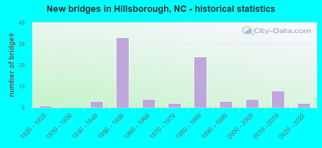
- New bridges - historical statistics
- 11920-1929
- 31940-1949
- 331950-1959
- 41960-1969
- 21970-1979
- 241980-1989
- 31990-1999
- 42000-2009
- 82010-2019
- 22020-2022
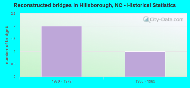
- Reconstructed bridges - Historical Statistics
- 21970-1979
- 11980-1989
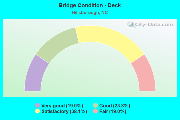
- Bridge Condition - Deck
- 19.0%Very good
- 23.8%Good
- 38.1%Satisfactory
- 19.0%Fair
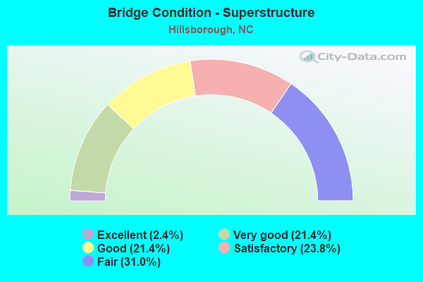
- Bridge Condition - Superstructure
- 2.4%Excellent
- 21.4%Very good
- 21.4%Good
- 23.8%Satisfactory
- 31.0%Fair
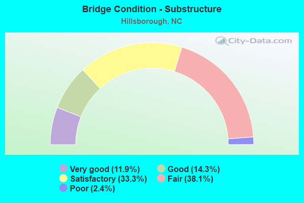
- Bridge Condition - Substructure
- 11.9%Very good
- 14.3%Good
- 33.3%Satisfactory
- 38.1%Fair
- 2.4%Poor
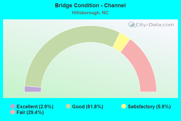
- Bridge Condition - Channel
- 2.9%Excellent
- 61.8%Good
- 5.9%Satisfactory
- 29.4%Fair
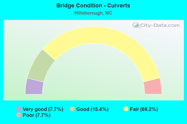
- Bridge Condition - Culverts
- 7.7%Very good
- 15.4%Good
- 69.2%Fair
- 7.7%Poor
Find on map >> Show street view
Structure Number: 1350221, Location: 0.2 MI. W. JCT. SR1134 (Lat: 36.040864, Lng: -79.143239), Route carried "on" structure: State highway 1135, Year Built: 2016, Status: Open, Structure Length: 0.76m (2.49ft), Average Daily Traffic: 240 (year 2000), Truck Traffic: 6%, Average Future Daily Traffic: 480 (year 2040), Design Load: HL 93, Features Intersected: ROCKY RUN
Minimum Vertical Clearance: 30+ m (98+ ft), Kilometerpoint: 0.000, Lanes on structure: 2, Owner: State Highway Agency, Approaching Roadway Width: 5.4m (17.7ft), Skew: 1 degrees, Material/Design: Concrete continuous, Design/Construction: Culvert, Length of Maximum Span: 3.6m (11.8ft)
Condition: Channel: Fair, Culverts: Good, Operating Rating: 58.0 metric tons, Method Used To Determine Operating Rating: Load and Resistance Factor (LRFR), Inventory Rating: 44.4 metric tons, Method Used To Determine Inventory Rating: Load and Resistance Factor (LRFR), Structural Evaluation: Better than present minimum criteria, Waterway Adequacy: Better than present minimum criteria, Approach Roadway Alignment: Equal to present minimum criteria, Designated Inspection Frequency: Every 24 months, Inspection Date: January 2021
Find on map >> Show street view
Structure Number: 1350228, Location: 0.4 MI. N. JCT. SR1723 (Lat: 36.004839, Lng: -79.107247), Route carried "on" structure: State highway 1009, Year Built: 1974, Status: Posted for load, Structure Length: 1.82m (5.97ft), Average Daily Traffic: 4,800 (year 2019), Truck Traffic: 7%, Average Future Daily Traffic: 9,600 (year 2040), Design Load: HS 20+Mod, Features Intersected: NEW HOPE CREEK
Minimum Vertical Clearance: 30+ m (98+ ft), Kilometerpoint: 0.000, Lanes on structure: 2, Owner: State Highway Agency, Approaching Roadway Width: 6.4m (21.0ft), Material/Design: Prestressed concrete, Design/Construction: Channel Beam, Number Of Spans In Main Unit: 2, Length of Maximum Span: 8.8m (28.9ft), Curb or Sidewalk Widths: Left: 0.1m (0.3ft), Right: 0.1m (0.3ft), Curb-To-Curb Width: 7.3m (24.0ft), Out-to-Out Width: 7.7m (25.3ft)
Condition: Deck: Fair, Superstructure: Fair, Substructure: Fair, Channel: Good, Operating Rating: 37.1 metric tons, Method Used To Determine Operating Rating: Load Factor (LF), Inventory Rating: 19.9 metric tons, Method Used To Determine Inventory Rating: Load Factor (LF), Structural Evaluation: Somewhat better than minimum adequacy, Deck Geometry: High priority of replacement, Waterway Adequacy: Better than present minimum criteria, Approach Roadway Alignment: Equal to present desirable criteria, Bridge Posting: Required (Relationship of Operating Rating to Maximum Legal Load: 0.1 - 9.9% below), Designated Inspection Frequency: Every 24 months, Inspection Date: October 2021, Deck Structure Type: Concrete Cast-file-Place, Wearing Surface/Protective System: Wearing Surface: Bituminous
Find on map >> Show street view
Structure Number: 1350241, Location: .02 MI.SW. JCT.NC86 (Lat: 36.072567, Lng: -79.099956), Route carried "on" structure: City street , Year Built: 1922, Status: Open, Structure Length: 7.98m (26.18ft), Average Daily Traffic: 100 (year 1985), Average Future Daily Traffic: 200 (year 2040), Design Load: H 15, Features Intersected: ENO RIVER, Facility Carried by Structure: EXCHANGE PARK LANE
Minimum Vertical Clearance: 30+ m (98+ ft), Kilometerpoint: 0.000, Lanes on structure: 2, Owner: City or Municipal Highway Agency, Approaching Roadway Width: 6.0m (19.7ft), Material/Design: Concrete, Design/Construction: Tee Beam, Number Of Spans In Main Unit: 5, Length of Maximum Span: 15.2m (49.9ft), Curb or Sidewalk Widths: Left: 1.5m (4.9ft), Right: 1.5m (4.9ft), Curb-To-Curb Width: 6.0m (19.7ft), Out-to-Out Width: 9.7m (31.8ft)
Condition: Deck: Fair, Superstructure: Fair, Substructure: Fair, Channel: Satisfactory, Operating Rating: 21.7 metric tons, Method Used To Determine Operating Rating: Field evaluation and documented engineering judgment, Inventory Rating: 16.3 metric tons, Method Used To Determine Inventory Rating: Field evaluation and documented engineering judgment, Structural Evaluation: Somewhat better than minimum adequacy, Deck Geometry: Meets minimum limits, Waterway Adequacy: Better than present minimum criteria, Approach Roadway Alignment: Equal to present desirable criteria, Designated Inspection Frequency: Every 24 months, Inspection Date: April 2020, Deck Structure Type: Concrete Cast-file-Place, Wearing Surface/Protective System: Wearing Surface: Bituminous
Find on map >> Show street view
Structure Number: 135026, Location: 2.1 MI. S. JCT. SR1009 (Lat: 36.009461, Lng: -79.084314), Route carried "on" structure: State highway 1723, Year Built: 1986, Status: Open, Structure Length: 5.76m (18.90ft), Average Daily Traffic: 4,800 (year 2017), Truck Traffic: 7%, Average Future Daily Traffic: 9,600 (year 2040), Design Load: HS 20+Mod, Features Intersected: I40
Minimum Vertical Clearance: 30+ m (98+ ft), Kilometerpoint: 80.163, Lanes on structure: 2, Lanes under structure: 4, Owner: State Highway Agency, Approaching Roadway Width: 12.1m (39.7ft), Skew: 1 degrees, Material/Design: Steel, Design/Construction: Stringer/Multi-beam, Number Of Spans In Main Unit: 2, Length of Maximum Span: 30.4m (99.7ft), Curb-To-Curb Width: 12.1m (39.7ft), Out-to-Out Width: 13.0m (42.7ft)
Condition: Deck: Satisfactory, Superstructure: Good, Substructure: Satisfactory, Operating Rating: 89.8 metric tons, Method Used To Determine Operating Rating: Load Factor (LF), Inventory Rating: 64.4 metric tons, Method Used To Determine Inventory Rating: Load Factor (LF), Structural Evaluation: Equal to present minimum criteria, Deck Geometry: Somewhat better than minimum adequacy, Underclear: Equal to present minimum criteria, Approach Roadway Alignment: Equal to present desirable criteria, Designated Inspection Frequency: Every 24 months, Inspection Date: March 2021, Deck Structure Type: Concrete Cast-file-Place, Wearing Surface/Protective System: Wearing Surface: Monolithic Concrete
Find on map >> Show street view
Structure Number: 1350262, Location: 100 FT. S. JCT. SR1133 (Lat: 36.052614, Lng: -79.122178), Route carried "on" structure: State highway 1006, Year Built: 1986, Status: Open, Structure Length: 6.15m (20.18ft), Average Daily Traffic: 5,400 (year 2019), Truck Traffic: 7%, Average Future Daily Traffic: 10,800 (year 2040), Design Load: HS 20+Mod, Features Intersected: I40
Minimum Vertical Clearance: 30+ m (98+ ft), Kilometerpoint: 0.000, Lanes on structure: 2, Lanes under structure: 4, Owner: State Highway Agency, Approaching Roadway Width: 8.5m (27.9ft), Material/Design: Steel, Design/Construction: Stringer/Multi-beam, Number Of Spans In Main Unit: 2, Number Of Approach Spans: 2, Length of Maximum Span: 30.7m (100.7ft), Curb-To-Curb Width: 8.5m (27.9ft), Out-to-Out Width: 9.4m (30.8ft)
Condition: Deck: Good, Superstructure: Good, Substructure: Fair, Operating Rating: 89.8 metric tons, Method Used To Determine Operating Rating: Load Factor (LF), Inventory Rating: 66.2 metric tons, Method Used To Determine Inventory Rating: Load Factor (LF), Structural Evaluation: Somewhat better than minimum adequacy, Deck Geometry: Meets minimum limits, Underclear: Equal to present minimum criteria, Approach Roadway Alignment: Equal to present desirable criteria, Designated Inspection Frequency: Every 24 months, Inspection Date: March 2021, Deck Structure Type: Concrete Cast-file-Place, Wearing Surface/Protective System: Wearing Surface: Monolithic Concrete
Find on map >> Show street view
Structure Number: 1350267, Location: 0.99 MI. W. JCT. SR1006 (Lat: 36.059400, Lng: -79.130411), Route carried "on" structure: Ramp Interstate 40, Year Built: 1987, Status: Open, Structure Length: 10.05m (32.97ft), Average Daily Traffic: 14,333 (year 2015), Truck Traffic: 16%, Average Future Daily Traffic: 28,666 (year 2040), Design Load: HS 20+Mod, Features Intersected: I40E,I85E, Facility Carried by Structure: I85S RAMP
Minimum Vertical Clearance: 30+ m (98+ ft), Kilometerpoint: 49.622, Lanes on structure: 2, Lanes under structure: 8, Base Highway Network: Yes (Inventory Route: 1, Subroute: 40), Owner: State Highway Agency, Approaching Roadway Width: 7.3m (24.0ft), Skew: 9 degrees, Material/Design: Prestressed concrete, Design/Construction: Stringer/Multi-beam, Number Of Spans In Main Unit: 5, Length of Maximum Span: 27.1m (88.9ft), Curb-To-Curb Width: 7.3m (24.0ft), Out-to-Out Width: 8.1m (26.6ft)
Condition: Deck: Satisfactory, Superstructure: Good, Substructure: Satisfactory, Operating Rating: 77.1 metric tons, Method Used To Determine Operating Rating: Load Factor (LF), Inventory Rating: 39.9 metric tons, Method Used To Determine Inventory Rating: Load Factor (LF), Structural Evaluation: Equal to present minimum criteria, Deck Geometry: High priority of replacement, Underclear: Somewhat better than minimum adequacy, Approach Roadway Alignment: Equal to present desirable criteria, Designated Inspection Frequency: Every 24 months, Inspection Date: May 2021, Deck Structure Type: Concrete Cast-file-Place, Wearing Surface/Protective System: Wearing Surface: Integral Concrete, Deck Protection: Epoxy Coated Reinforcing
Find on map >> Show street view
Structure Number: 1350268, Location: 0.77 MI. W. JCT. SR1006 (Lat: 36.059072, Lng: -79.125675), Route carried "on" structure: Interstate 40, Year Built: 1987, Status: Open, Structure Length: 9.78m (32.09ft), Average Daily Traffic: 31,500 (year 2019), Truck Traffic: 16%, Average Future Daily Traffic: 63,000 (year 2040), Design Load: HS 20+Mod, Features Intersected: I85
Minimum Vertical Clearance: 30+ m (98+ ft), Kilometerpoint: 78.761, Lanes on structure: 2, Lanes under structure: 7, Base Highway Network: Yes (Inventory Route: 1, Subroute: 40), Owner: State Highway Agency, Approaching Roadway Width: 10.3m (33.8ft), Skew: 9 degrees, Material/Design: Steel, Design/Construction: Stringer/Multi-beam, Number Of Spans In Main Unit: 3, Length of Maximum Span: 39.6m (129.9ft), Curb-To-Curb Width: 12.1m (39.7ft), Out-to-Out Width: 13.0m (42.7ft)
Condition: Deck: Satisfactory, Superstructure: Good, Substructure: Satisfactory, Operating Rating: 82.5 metric tons, Method Used To Determine Operating Rating: Load Factor (LF), Inventory Rating: 49.8 metric tons, Method Used To Determine Inventory Rating: Load Factor (LF), Structural Evaluation: Equal to present minimum criteria, Deck Geometry: Equal to present minimum criteria, Underclear: Somewhat better than minimum adequacy, Approach Roadway Alignment: Equal to present desirable criteria, Designated Inspection Frequency: Every 24 months, Inspection Date: May 2021, Deck Structure Type: Concrete Cast-file-Place, Wearing Surface/Protective System: Wearing Surface: Monolithic Concrete, Deck Protection: Epoxy Coated Reinforcing
Find on map >> Show street view
Structure Number: 1350269, Location: 1.5 MI. E. JCT. SR1120 (Lat: 36.062444, Lng: -79.136994), Route carried "on" structure: Interstate 40, Year Built: 1957, Year Reconstructed: 1987, Status: Open, Structure Length: 1.21m (3.97ft), Average Daily Traffic: 113,000 (year 2019), Truck Traffic: 23%, Average Future Daily Traffic: 226,000 (year 2040), Design Load: HS 20+Mod, Features Intersected: SEVEN MILE CREEK
Minimum Vertical Clearance: 30+ m (98+ ft), Kilometerpoint: 49.347, Lanes on structure: 4, Base Highway Network: Yes (Inventory Route: 1, Subroute: 85), Owner: State Highway Agency, Approaching Roadway Width: 44.1m (144.7ft), Skew: 30 degrees, Material/Design: Concrete, Design/Construction: Culvert, Number Of Spans In Main Unit: 1, Length of Maximum Span: 12.1m (39.7ft)
Condition: Channel: Good, Culverts: Fair, Operating Rating: 41.7 metric tons, Method Used To Determine Operating Rating: Field evaluation and documented engineering judgment, Inventory Rating: 32.6 metric tons, Method Used To Determine Inventory Rating: Field evaluation and documented engineering judgment, Structural Evaluation: Somewhat better than minimum adequacy, Waterway Adequacy: Better than present minimum criteria, Approach Roadway Alignment: Equal to present desirable criteria, Designated Inspection Frequency: Every 24 months, Inspection Date: August 2021
Find on map >> Show street view
Structure Number: 135027, Location: 2.5 MI. E. JCT. I85 (Lat: 36.037050, Lng: -79.097483), Route carried "on" structure: Interstate 40, Year Built: 1987, Status: Open, Structure Length: 5.21m (17.09ft), Average Daily Traffic: 38,000 (year 2017), Truck Traffic: 16%, Average Future Daily Traffic: 76,000 (year 2040), Design Load: HS 20+Mod, Features Intersected: SR1009
Minimum Vertical Clearance: 30+ m (98+ ft), Kilometerpoint: 79.553, Lanes on structure: 2, Lanes under structure: 3, Base Highway Network: Yes (Inventory Route: 1, Subroute: 40), Owner: State Highway Agency, Approaching Roadway Width: 12.8m (42.0ft), Skew: 13 degrees, Material/Design: Prestressed concrete, Design/Construction: Stringer/Multi-beam, Number Of Spans In Main Unit: 3, Length of Maximum Span: 26.5m (86.9ft), Curb-To-Curb Width: 12.1m (39.7ft), Out-to-Out Width: 13.1m (43.0ft)
Condition: Deck: Satisfactory, Superstructure: Satisfactory, Substructure: Satisfactory, Operating Rating: 67.1 metric tons, Method Used To Determine Operating Rating: Load Factor (LF), Inventory Rating: 39.9 metric tons, Method Used To Determine Inventory Rating: Load Factor (LF), Structural Evaluation: Equal to present minimum criteria, Deck Geometry: Equal to present minimum criteria, Underclear: High priority of corrective action, Approach Roadway Alignment: Equal to present desirable criteria, Designated Inspection Frequency: Every 24 months, Inspection Date: January 2021, Deck Structure Type: Concrete Cast-file-Place, Wearing Surface/Protective System: Wearing Surface: Monolithic Concrete
Find on map >> Show street view
Structure Number: 1350271, Location: 2.5 MI. E. JCT. I85 (Lat: 36.036817, Lng: -79.097408), Route carried "on" structure: Interstate 40, Year Built: 1987, Status: Open, Structure Length: 5.02m (16.47ft), Average Daily Traffic: 35,500 (year 2019), Truck Traffic: 16%, Average Future Daily Traffic: 71,000 (year 2040), Design Load: HS 20+Mod, Features Intersected: SR1009
Minimum Vertical Clearance: 30+ m (98+ ft), Kilometerpoint: 79.553, Lanes on structure: 2, Lanes under structure: 3, Base Highway Network: Yes (Inventory Route: 1, Subroute: 40), Owner: State Highway Agency, Approaching Roadway Width: 12.4m (40.7ft), Skew: 13 degrees, Material/Design: Prestressed concrete, Design/Construction: Stringer/Multi-beam, Number Of Spans In Main Unit: 3, Length of Maximum Span: 26.8m (87.9ft), Curb-To-Curb Width: 12.1m (39.7ft), Out-to-Out Width: 13.1m (43.0ft)
Condition: Deck: Satisfactory, Superstructure: Satisfactory, Substructure: Satisfactory, Operating Rating: 64.4 metric tons, Method Used To Determine Operating Rating: Load Factor (LF), Inventory Rating: 38.1 metric tons, Method Used To Determine Inventory Rating: Load Factor (LF), Structural Evaluation: Equal to present minimum criteria, Deck Geometry: Equal to present minimum criteria, Underclear: Meets minimum limits, Approach Roadway Alignment: Equal to present desirable criteria, Designated Inspection Frequency: Every 24 months, Inspection Date: January 2021, Deck Structure Type: Concrete Cast-file-Place, Wearing Surface/Protective System: Wearing Surface: Monolithic Concrete, Deck Protection: Epoxy Coated Reinforcing
Find on map >> Show street view
Structure Number: 135034, Location: 0.4 MI. S. JONES FERRY RD (Lat: 35.900214, Lng: -79.086825), Route carried "on" structure: City street , Year Built: 2010, Status: Open, Structure Length: 3.56m (11.68ft), Average Daily Traffic: 3,800 (year 2017), Truck Traffic: 7%, Average Future Daily Traffic: 7,600 (year 2040), Design Load: HS 20, Features Intersected: TOM'S CREEK, Facility Carried by Structure: BERRYHILL DR.
Minimum Vertical Clearance: 30+ m (98+ ft), Kilometerpoint: 0.000, Lanes on structure: 2, Owner: City or Municipal Highway Agency, Approaching Roadway Width: 14.0m (45.9ft), Material/Design: Prestressed concrete, Design/Construction: Slab, Number Of Spans In Main Unit: 2, Length of Maximum Span: 17.9m (58.7ft), Curb or Sidewalk Widths: Left: 1.6m (5.2ft), Right: 1.6m (5.2ft), Curb-To-Curb Width: 10.5m (34.4ft), Out-to-Out Width: 14.6m (47.9ft)
Condition: Deck: Good, Superstructure: Good, Substructure: Very good, Channel: Satisfactory, Operating Rating: 73.4 metric tons, Method Used To Determine Operating Rating: Load and Resistance Factor (LRFR), Inventory Rating: 43.5 metric tons, Method Used To Determine Inventory Rating: Load and Resistance Factor (LRFR), Structural Evaluation: Better than present minimum criteria, Deck Geometry: Somewhat better than minimum adequacy, Waterway Adequacy: Equal to present desirable criteria, Approach Roadway Alignment: Equal to present desirable criteria, Designated Inspection Frequency: Every 24 months, Inspection Date: April 2020, Deck Structure Type: Concrete Precast Panels, Wearing Surface/Protective System: Wearing Surface: Bituminous
Find on map >> Show street view
Structure Number: 1350341, Location: 0.4 MI. S. JCT. NC86 (Lat: 36.057972, Lng: -79.089189), Route carried "on" structure: Interstate 85, Year Built: 1950, Status: Open, Structure Length: 0.94m (3.08ft), Average Daily Traffic: 56,000 (year 2018), Truck Traffic: 16%, Average Future Daily Traffic: 112,000 (year 2040), Design Load: HS 20, Features Intersected: CATES CREEK
Minimum Vertical Clearance: 30+ m (98+ ft), Kilometerpoint: 50.292, Lanes on structure: 4, Base Highway Network: Yes (Inventory Route: 1, Subroute: 85), Owner: State Highway Agency, Approaching Roadway Width: 17.6m (57.7ft), Skew: 24 degrees, Material/Design: Concrete continuous, Design/Construction: Culvert, Number Of Spans In Main Unit: 3, Length of Maximum Span: 2.1m (6.9ft)
Condition: Channel: Fair, Culverts: Fair, Operating Rating: 41.7 metric tons, Method Used To Determine Operating Rating: Field evaluation and documented engineering judgment, Inventory Rating: 32.6 metric tons, Method Used To Determine Inventory Rating: Field evaluation and documented engineering judgment, Structural Evaluation: Somewhat better than minimum adequacy, Waterway Adequacy: Better than present minimum criteria, Approach Roadway Alignment: Equal to present desirable criteria, Designated Inspection Frequency: Every 24 months, Inspection Date: May 2020
Find on map >> Show street view
Structure Number: 1350346, Location: 0.2 MI. E. JCT. SR1009 (Lat: 36.048033, Lng: -79.098647), Route carried "on" structure: City street , Year Built: 2008, Status: Open, Structure Length: 1.46m (4.79ft), Average Daily Traffic: 100 (year 2017), Truck Traffic: 6%, Average Future Daily Traffic: 200 (year 2040), Design Load: HS 20, Features Intersected: CATES CREEK, Facility Carried by Structure: CATES CREEK PKWY
Minimum Vertical Clearance: 30+ m (98+ ft), Kilometerpoint: 0.000, Lanes on structure: 2, Owner: City or Municipal Highway Agency, Approaching Roadway Width: 6.7m (22.0ft), Material/Design: Concrete, Design/Construction: Culvert, Number Of Spans In Main Unit: 1, Length of Maximum Span: 14.6m (47.9ft)
Condition: Channel: Good, Culverts: Good, Operating Rating: 41.7 metric tons, Method Used To Determine Operating Rating: Field evaluation and documented engineering judgment, Inventory Rating: 32.6 metric tons, Method Used To Determine Inventory Rating: Field evaluation and documented engineering judgment, Structural Evaluation: Better than present minimum criteria, Waterway Adequacy: Better than present minimum criteria, Approach Roadway Alignment: Equal to present desirable criteria, Designated Inspection Frequency: Every 24 months, Inspection Date: April 2020
Find on map >> Show street view
Structure Number: 1350059, Location: 0.6 MI. S. JCT. US70 BUS (Lat: 36.058844, Lng: -79.082361), Route carried "under" structure: Interstate 85, Year Built: 1957, Structure Length: 0. m, Average Daily Traffic: 28,250 (year 2019), Truck Traffic: 16%, Features Intersected: NC86
Minimum Vertical Clearance: 4.64m (15.22ft), Kilometerpoint: 50.414, Lanes on structure: 2, Lanes under structure: 2, Material/Design: Steel, Design/Construction: Stringer/Multi-beam, Length of Maximum Span: 24.0m (78.7ft)
Find on map >> Show street view
Structure Number: 1350059, Location: 0.6 MI. S. JCT. US70 BUS (Lat: 36.058844, Lng: -79.082361), Route carried "under" structure: Interstate 85, Year Built: 1957, Structure Length: 0. m, Average Daily Traffic: 28,250 (year 2019), Truck Traffic: 16%, Features Intersected: NC86
Minimum Vertical Clearance: 5.18m (16.99ft), Kilometerpoint: 50.414, Lanes on structure: 2, Lanes under structure: 2, Material/Design: Steel, Design/Construction: Stringer/Multi-beam, Length of Maximum Span: 24.0m (78.7ft)
Find on map >> Show street view
Structure Number: 1350079, Location: 0.3 MI. S. JCT. I85 (Lat: 36.061606, Lng: -79.135217), Route carried "under" structure: Interstate 40, Year Built: 1986, Structure Length: 0. m, Average Daily Traffic: 62,000 (year 2018), Truck Traffic: 23%, Features Intersected: SR1134
Minimum Vertical Clearance: 5.56m (18.24ft), Kilometerpoint: 49.530, Lanes on structure: 2, Lanes under structure: 5, Material/Design: Steel, Design/Construction: Stringer/Multi-beam, Length of Maximum Span: 39.0m (128.0ft)
Find on map >> Show street view
Structure Number: 1350079, Location: 0.3 MI. S. JCT. I85 (Lat: 36.061606, Lng: -79.135217), Route carried "under" structure: Interstate 40, Year Built: 1986, Structure Length: 0. m, Average Daily Traffic: 62,000 (year 2018), Truck Traffic: 23%, Features Intersected: SR1134
Minimum Vertical Clearance: 5.18m (16.99ft), Kilometerpoint: 49.530, Lanes on structure: 2, Lanes under structure: 4, Material/Design: Steel, Design/Construction: Stringer/Multi-beam, Length of Maximum Span: 39.0m (128.0ft)
Find on map >> Show street view
Structure Number: 1350081, Location: 0.5 MI.S. JCT. SR1009 (Lat: 36.059006, Lng: -79.112317), Route carried "under" structure: State highway 1006, Year Built: 1957, Structure Length: 0. m, Average Daily Traffic: 9,500 (year 2019), Truck Traffic: 7%, Features Intersected: I85N,NC86, Facility Carried by Structure: H
Minimum Vertical Clearance: 4.39m (14.40ft), Kilometerpoint: 0.000, Lanes on structure: 2, Lanes under structure: 2, Material/Design: Steel, Design/Construction: Stringer/Multi-beam, Length of Maximum Span: 21.0m (68.9ft)
Find on map >> Show street view
Structure Number: 1350082, Location: 0.3 MI. S. JCT. SR1009 (Lat: 36.059214, Lng: -79.111978), Route carried "under" structure: State highway 1006, Year Built: 1957, Structure Length: 0. m, Average Daily Traffic: 9,500 (year 2019), Truck Traffic: 7%, Features Intersected: I85S, NC86
Minimum Vertical Clearance: 5.43m (17.81ft), Kilometerpoint: 0.000, Lanes on structure: 2, Lanes under structure: 2, Material/Design: Steel, Design/Construction: Stringer/Multi-beam, Length of Maximum Span: 21.0m (68.9ft)
Find on map >> Show street view
Structure Number: 1350083, Location: 1.3 MI. N. JCT. I40 (Lat: 36.056950, Lng: -79.104111), Route carried "under" structure: State highway 1009, Year Built: 1958, Structure Length: 0. m, Average Daily Traffic: 25,000 (year 2018), Truck Traffic: 6%, Features Intersected: I85N,NC86
Minimum Vertical Clearance: 4.59m (15.06ft), Kilometerpoint: 0.000, Lanes on structure: 2, Lanes under structure: 2, Material/Design: Prestressed concrete, Design/Construction: Stringer/Multi-beam, Length of Maximum Span: 15.2m (49.9ft)
Find on map >> Show street view
Structure Number: 1350087, Location: 1.3 MI. N. JCT. I40 (Lat: 36.057131, Lng: -79.104075), Route carried "under" structure: State highway 1009, Year Built: 1958, Structure Length: 0. m, Average Daily Traffic: 25,000 (year 2018), Truck Traffic: 6%, Features Intersected: I85S,NC86
Minimum Vertical Clearance: 4.85m (15.91ft), Kilometerpoint: 0.000, Lanes on structure: 2, Lanes under structure: 2, Material/Design: Prestressed concrete, Design/Construction: Stringer/Multi-beam, Length of Maximum Span: 15.2m (49.9ft)
Find on map >> Show street view
Structure Number: 1350095, Location: 0.3 MI. N. JCT. SR1710 (Lat: 36.053967, Lng: -79.067794), Route carried "under" structure: Interstate 85, Year Built: 1957, Structure Length: 0. m, Average Daily Traffic: 28,000 (year 2019), Truck Traffic: 16%, Features Intersected: SR1709
Minimum Vertical Clearance: 4.87m (15.98ft), Kilometerpoint: 50.688, Lanes on structure: 2, Lanes under structure: 2, Material/Design: Prestressed concrete, Design/Construction: Stringer/Multi-beam, Length of Maximum Span: 17.3m (56.8ft)
Find on map >> Show street view
Structure Number: 1350095, Location: 0.3 MI. N. JCT. SR1710 (Lat: 36.053967, Lng: -79.067794), Route carried "under" structure: Interstate 85, Year Built: 1957, Structure Length: 0. m, Average Daily Traffic: 28,000 (year 2019), Truck Traffic: 16%, Features Intersected: SR1709
Minimum Vertical Clearance: 5.56m (18.24ft), Kilometerpoint: 50.688, Lanes on structure: 2, Lanes under structure: 2, Material/Design: Prestressed concrete, Design/Construction: Stringer/Multi-beam, Length of Maximum Span: 17.3m (56.8ft)
Find on map >> Show street view
Structure Number: 1350096, Location: 0.2 MI. N. JCT. SR1817 (Lat: 36.041167, Lng: -79.030758), Route carried "under" structure: Interstate 85, Year Built: 1957, Structure Length: 0. m, Average Daily Traffic: 26,750 (year 2019), Truck Traffic: 16%, Features Intersected: SR1712
Minimum Vertical Clearance: 4.92m (16.14ft), Kilometerpoint: 51.420, Lanes on structure: 2, Lanes under structure: 2, Material/Design: Steel, Design/Construction: Stringer/Multi-beam, Length of Maximum Span: 19.5m (64.0ft)
Find on map >> Show street view
Structure Number: 1350096, Location: 0.2 MI. N. JCT. SR1817 (Lat: 36.041167, Lng: -79.030758), Route carried "under" structure: Interstate 85, Year Built: 1957, Structure Length: 0. m, Average Daily Traffic: 26,750 (year 2019), Truck Traffic: 16%, Features Intersected: SR1712
Minimum Vertical Clearance: 5.25m (17.22ft), Kilometerpoint: 51.420, Lanes on structure: 2, Lanes under structure: 2, Material/Design: Steel, Design/Construction: Stringer/Multi-beam, Length of Maximum Span: 19.5m (64.0ft)
Find on map >> Show street view
Structure Number: 1350098, Location: 0.5 MI. S. JCT. US70 (Lat: 36.038725, Lng: -79.017208), Route carried "under" structure: State highway 1713, Year Built: 1958, Structure Length: 0. m, Average Daily Traffic: 2,900 (year 2019), Truck Traffic: 6%, Features Intersected: I85N
Minimum Vertical Clearance: 6.17m (20.24ft), Kilometerpoint: 0.000, Lanes on structure: 2, Lanes under structure: 2, Material/Design: Steel, Design/Construction: Stringer/Multi-beam, Length of Maximum Span: 16.4m (53.8ft)
Find on map >> Show street view
Structure Number: 1350106, Location: 0.65 MI. N. JCT. SR1567 (Lat: 36.038678, Lng: -79.011917), Route carried "under" structure: US 70, Year Built: 1958, Structure Length: 0. m, Average Daily Traffic: 18,500 (year 2019), Truck Traffic: 6%, Features Intersected: I85S, US70W
Minimum Vertical Clearance: 5.05m (16.57ft), Kilometerpoint: 0.000, Lanes on structure: 3, Lanes under structure: 2, Material/Design: Steel, Design/Construction: Stringer/Multi-beam, Length of Maximum Span: 23.1m (75.8ft)
Find on map >> Show street view
Structure Number: 135011, Location: 0.6 MI. N. JCT. SR1712 (Lat: 36.038367, Lng: -79.008572), Route carried "under" structure: Business US 70, Year Built: 1958, Structure Length: 0. m, Average Daily Traffic: 7,700 (year 2018), Truck Traffic: 6%, Features Intersected: I85SN,US70E
Minimum Vertical Clearance: 5.33m (17.49ft), Kilometerpoint: 51.755, Lanes on structure: 3, Lanes under structure: 2, Material/Design: Steel, Design/Construction: Stringer/Multi-beam, Length of Maximum Span: 19.8m (65.0ft)
Find on map >> Show street view
Structure Number: 1350111, Location: 0.6 MI. N. JCT. SR1712 (Lat: 36.038542, Lng: -79.008781), Route carried "under" structure: Business US 70, Year Built: 1958, Structure Length: 0. m, Average Daily Traffic: 7,700 (year 2017), Truck Traffic: 6%, Features Intersected: I85 SBL
Minimum Vertical Clearance: 4.92m (16.14ft), Kilometerpoint: 0.000, Lanes on structure: 2, Lanes under structure: 2, Material/Design: Steel, Design/Construction: Stringer/Multi-beam, Length of Maximum Span: 20.7m (67.9ft)
Find on map >> Show street view
Structure Number: 135026, Location: 2.1 MI. S. JCT. SR1009 (Lat: 36.009461, Lng: -79.084314), Route carried "under" structure: Interstate 40, Year Built: 1986, Structure Length: 0. m, Average Daily Traffic: 38,000 (year 2017), Truck Traffic: 16%, Features Intersected: SR1723
Minimum Vertical Clearance: 5.43m (17.81ft), Kilometerpoint: 80.132, Lanes on structure: 2, Lanes under structure: 2, Material/Design: Steel, Design/Construction: Stringer/Multi-beam, Length of Maximum Span: 30.4m (99.7ft)
Find on map >> Show street view
Structure Number: 135026, Location: 2.1 MI. S. JCT. SR1009 (Lat: 36.009461, Lng: -79.084314), Route carried "under" structure: Interstate 40, Year Built: 1986, Structure Length: 0. m, Average Daily Traffic: 38,000 (year 2017), Truck Traffic: 16%, Features Intersected: SR1723
Minimum Vertical Clearance: 6.85m (22.47ft), Kilometerpoint: 80.132, Lanes on structure: 2, Lanes under structure: 2, Material/Design: Steel, Design/Construction: Stringer/Multi-beam, Length of Maximum Span: 30.4m (99.7ft)
Find on map >> Show street view
Structure Number: 1350262, Location: 100 FT. S. JCT. SR1133 (Lat: 36.052614, Lng: -79.122178), Route carried "under" structure: Interstate 40, Year Built: 1986, Structure Length: 0. m, Average Daily Traffic: 31,500 (year 2019), Truck Traffic: 16%, Features Intersected: SR1006
Minimum Vertical Clearance: 5.58m (18.31ft), Kilometerpoint: 78.913, Lanes on structure: 2, Lanes under structure: 2, Material/Design: Steel, Design/Construction: Stringer/Multi-beam, Length of Maximum Span: 30.7m (100.7ft)
Find on map >> Show street view
Structure Number: 1350262, Location: 100 FT. S. JCT. SR1133 (Lat: 36.052614, Lng: -79.122178), Route carried "under" structure: Interstate 40, Year Built: 1986, Structure Length: 0. m, Average Daily Traffic: 31,500 (year 2019), Truck Traffic: 16%, Features Intersected: SR1006
Minimum Vertical Clearance: 5.30m (17.39ft), Kilometerpoint: 78.913, Lanes on structure: 2, Lanes under structure: 2, Material/Design: Steel, Design/Construction: Stringer/Multi-beam, Length of Maximum Span: 30.7m (100.7ft)
Find on map >> Show street view
Structure Number: 1350267, Location: 0.99 MI. W. JCT. SR1006 (Lat: 36.059400, Lng: -79.130411), Route carried "under" structure: Interstate 85, Year Built: 1987, Structure Length: 0. m, Average Daily Traffic: 49,500 (year 2015), Truck Traffic: 16%, Features Intersected: I85S RAMP
Minimum Vertical Clearance: 6.68m (21.92ft), Kilometerpoint: 49.500, Lanes on structure: 2, Lanes under structure: 3, Material/Design: Prestressed concrete, Design/Construction: Stringer/Multi-beam, Length of Maximum Span: 27.1m (88.9ft)
Find on map >> Show street view
Structure Number: 1350267, Location: 0.99 MI. W. JCT. SR1006 (Lat: 36.059400, Lng: -79.130411), Route carried "under" structure: Interstate 85, Year Built: 1987, Structure Length: 0. m, Average Daily Traffic: 49,500 (year 2015), Truck Traffic: 16%, Features Intersected: I85S RAMP
Minimum Vertical Clearance: 7.18m (23.56ft), Kilometerpoint: 49.500, Lanes on structure: 2, Lanes under structure: 3, Material/Design: Prestressed concrete, Design/Construction: Stringer/Multi-beam, Length of Maximum Span: 27.1m (88.9ft)
Find on map >> Show street view
Structure Number: 1350267, Location: 0.99 MI. W. JCT. SR1006 (Lat: 36.059400, Lng: -79.130411), Route carried "under" structure: Interstate 40, Year Built: 1987, Structure Length: 0. m, Average Daily Traffic: 33,000 (year 2015), Truck Traffic: 16%, Features Intersected: I85S RAMP
Minimum Vertical Clearance: 5.25m (17.22ft), Kilometerpoint: 78.730, Lanes on structure: 2, Lanes under structure: 2, Material/Design: Prestressed concrete, Design/Construction: Stringer/Multi-beam, Length of Maximum Span: 27.1m (88.9ft)
Find on map >> Show street view
Structure Number: 1350268, Location: 0.77 MI. W. JCT. SR1006 (Lat: 36.059072, Lng: -79.125675), Route carried "under" structure: Interstate 85, Year Built: 1987, Structure Length: 0. m, Average Daily Traffic: 56,500 (year 2019), Truck Traffic: 16%, Features Intersected: I40W.
Minimum Vertical Clearance: 5.08m (16.67ft), Kilometerpoint: 49.591, Lanes on structure: 2, Lanes under structure: 3, Material/Design: Steel, Design/Construction: Stringer/Multi-beam, Length of Maximum Span: 39.6m (129.9ft)
Find on map >> Show street view
Structure Number: 1350268, Location: 0.77 MI. W. JCT. SR1006 (Lat: 36.059072, Lng: -79.125675), Route carried "under" structure: Interstate 85, Year Built: 1987, Structure Length: 0. m, Average Daily Traffic: 56,500 (year 2019), Truck Traffic: 16%, Features Intersected: I40W.
Minimum Vertical Clearance: 5.25m (17.22ft), Kilometerpoint: 49.591, Lanes on structure: 2, Lanes under structure: 4, Material/Design: Steel, Design/Construction: Stringer/Multi-beam, Length of Maximum Span: 39.6m (129.9ft)
Find on map >> Show street view
Structure Number: 135027, Location: 2.5 MI. E. JCT. I85 (Lat: 36.037050, Lng: -79.097483), Route carried "under" structure: State highway 1009, Year Built: 1987, Structure Length: 0. m, Average Daily Traffic: 7,500 (year 2017), Truck Traffic: 6%, Features Intersected: I40W
Minimum Vertical Clearance: 5.76m (18.90ft), Kilometerpoint: 0.000, Lanes on structure: 2, Lanes under structure: 2, Material/Design: Prestressed concrete, Design/Construction: Stringer/Multi-beam, Length of Maximum Span: 26.5m (86.9ft)
Find on map >> Show street view
Structure Number: 135027, Location: 2.5 MI. E. JCT. I85 (Lat: 36.037050, Lng: -79.097483), Route carried "under" structure: State highway 1009, Year Built: 1987, Structure Length: 0. m, Average Daily Traffic: 7,500 (year 2017), Truck Traffic: 6%, Features Intersected: I40W
Minimum Vertical Clearance: 5.91m (19.39ft), Kilometerpoint: 0.000, Lanes on structure: 2, Lanes under structure: 1, Material/Design: Prestressed concrete, Design/Construction: Stringer/Multi-beam, Length of Maximum Span: 26.5m (86.9ft)
Find on map >> Show street view
Structure Number: 1350271, Location: 2.5 MI. E. JCT. I85 (Lat: 36.036817, Lng: -79.097408), Route carried "under" structure: State highway 1009, Year Built: 1987, Structure Length: 0. m, Average Daily Traffic: 3,300 (year 2018), Truck Traffic: 7%, Features Intersected: I40E
Minimum Vertical Clearance: 5.25m (17.22ft), Kilometerpoint: 0.000, Lanes on structure: 2, Lanes under structure: 1, Material/Design: Prestressed concrete, Design/Construction: Stringer/Multi-beam, Length of Maximum Span: 26.8m (87.9ft)
Find on map >> Show street view
Structure Number: 1350271, Location: 2.5 MI. E. JCT. I85 (Lat: 36.036817, Lng: -79.097408), Route carried "under" structure: State highway 1009, Year Built: 1987, Structure Length: 0. m, Average Daily Traffic: 3,300 (year 2018), Truck Traffic: 7%, Features Intersected: I40E
Minimum Vertical Clearance: 5.13m (16.83ft), Kilometerpoint: 0.000, Lanes on structure: 2, Lanes under structure: 2, Material/Design: Prestressed concrete, Design/Construction: Stringer/Multi-beam, Length of Maximum Span: 26.8m (87.9ft)