Bridge Statistics for Hialeah, Florida (FL)
Condition, Traffic, Stress, Structural Evaluation, Project Costs
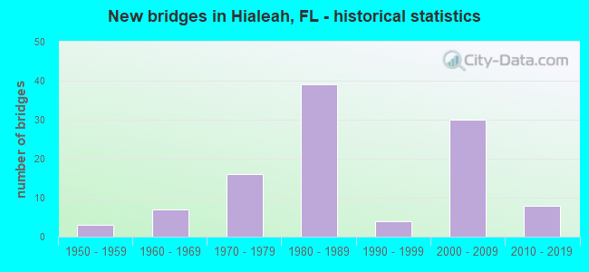
- New bridges - historical statistics
- 31950-1959
- 71960-1969
- 161970-1979
- 391980-1989
- 41990-1999
- 302000-2009
- 82010-2019
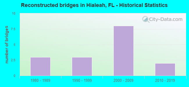
- Reconstructed bridges - Historical Statistics
- 31980-1989
- 31990-1999
- 82000-2009
- 22010-2019
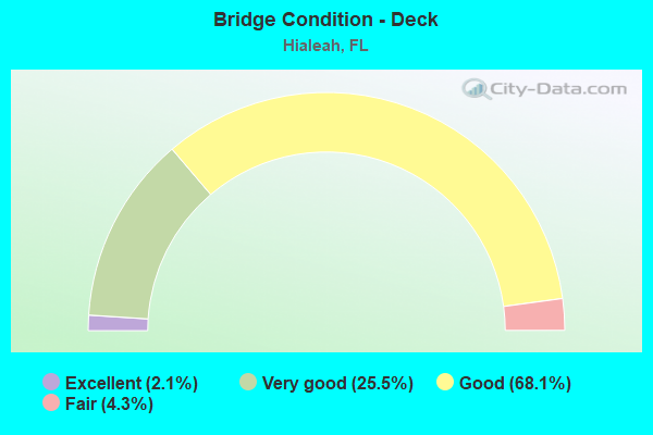
- Bridge Condition - Deck
- 2.1%Excellent
- 25.5%Very good
- 68.1%Good
- 4.3%Fair
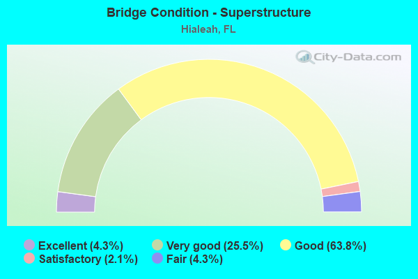
- Bridge Condition - Superstructure
- 4.3%Excellent
- 25.5%Very good
- 63.8%Good
- 2.1%Satisfactory
- 4.3%Fair
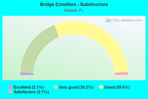
- Bridge Condition - Substructure
- 2.1%Excellent
- 36.2%Very good
- 59.6%Good
- 2.1%Satisfactory
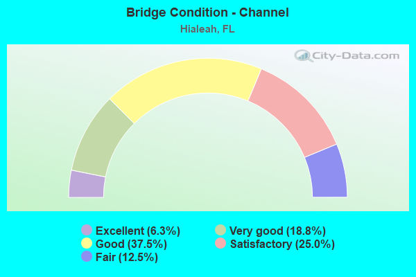
- Bridge Condition - Channel
- 6.3%Excellent
- 18.8%Very good
- 37.5%Good
- 25.0%Satisfactory
- 12.5%Fair
Find on map >> Show street view
Structure Number: 870026, Location: At US 27/SR 953 Off Ramps (Lat: 25.809722, Lng: -80.258375), Route carried "on" structure: State highway 112, Year Built: 1961, Year Reconstructed: 2003, Status: Open, Structure Length: 11.86m (38.91ft), Average Daily Traffic: 57,250 (year 2018), Truck Traffic: 8%, Average Future Daily Traffic: 99,329 (year 2040), Design Load: HS 20, Features Intersected: R/R & NW 37th Place
Minimum Vertical Clearance: 7.50m (24.61ft), Kilometerpoint: 2.060, Lanes on structure: 4, Lanes under structure: 2, Toll: On toll road, Owner: State Toll Authority, Approaching Roadway Width: 11.8m (38.7ft), Skew: 33 degrees, Material/Design: Steel, Design/Construction: Stringer/Multi-beam, Number Of Spans In Main Unit: 6, Length of Maximum Span: 20.1m (65.9ft), Curb-To-Curb Width: 11.8m (38.7ft), Out-to-Out Width: 23.5m (77.1ft)
Condition: Deck: Good, Superstructure: Good, Substructure: Very good, Operating Rating: 44.4 metric tons, Method Used To Determine Operating Rating: Load and Resistance Factor (LRFR), Inventory Rating: 34.2 metric tons, Method Used To Determine Inventory Rating: Load and Resistance Factor (LRFR), Structural Evaluation: Better than present minimum criteria, Deck Geometry: High priority of replacement, Underclear: Meets minimum limits, Approach Roadway Alignment: Equal to present desirable criteria, Designated Inspection Frequency: Every 24 months, Inspection Date: March 2021, Deck Structure Type: Concrete Cast-file-Place
Find on map >> Show street view
Structure Number: 870467, Location: I-75/SR-826 INTERCHANGE (Lat: 25.898608, Lng: -80.324303), Route carried "on" structure: State highway 826, Year Built: 1974, Year Reconstructed: 1985, Status: Open, Structure Length: 5.06m (16.60ft), Average Daily Traffic: 11,000 (year 2020), Truck Traffic: 12%, Average Future Daily Traffic: 19,085 (year 2042), Design Load: HL 93, Features Intersected: I-75 RAMP & NW 138 ST
Minimum Vertical Clearance: 5.33m (17.49ft), Kilometerpoint: 1.270, Lanes on structure: 7, Lanes under structure: 4, Base Highway Network: Yes, Owner: State Highway Agency, Approaching Roadway Width: 35.8m (117.5ft), Skew: 30 degrees, Material/Design: Prestressed concrete, Design/Construction: Stringer/Multi-beam, Number Of Spans In Main Unit: 2, Length of Maximum Span: 25.3m (83.0ft), Curb-To-Curb Width: 35.8m (117.5ft), Out-to-Out Width: 49.4m (162.1ft)
Condition: Deck: Good, Superstructure: Good, Substructure: Good, Operating Rating: 39.6 metric tons, Method Used To Determine Operating Rating: Load and Resistance Factor (LRFR), Inventory Rating: 33.7 metric tons, Method Used To Determine Inventory Rating: Load and Resistance Factor (LRFR), Structural Evaluation: Better than present minimum criteria, Deck Geometry: Superior to present desirable criteria, Underclear: Somewhat better than minimum adequacy, Approach Roadway Alignment: Equal to present desirable criteria, Designated Inspection Frequency: Every 24 months, Inspection Date: August 2020, Deck Structure Type: Concrete Cast-file-Place
Find on map >> Show street view
Structure Number: 87057, Location: N OF NW 103RD ST. (Lat: 25.869667, Lng: -80.322611), Route carried "on" structure: ServiceOther road 826, Year Built: 1968, Status: Open, Structure Length: 2.73m (8.96ft), Average Daily Traffic: 7,607 (year 2014), Average Future Daily Traffic: 13,198 (year 2036), Design Load: HL 93, Features Intersected: LITTLE RIVER CANAL C-7, Facility Carried by Structure: EAST FRONTAGE RD.
Minimum Vertical Clearance: 30+ m (98+ ft), Kilometerpoint: 0.317, Lanes on structure: 2, Owner: State Highway Agency, Approaching Roadway Width: 10.4m (34.1ft), Material/Design: Prestressed concrete, Design/Construction: Slab, Number Of Spans In Main Unit: 3, Length of Maximum Span: 9.1m (29.9ft), Curb-To-Curb Width: 10.4m (34.1ft), Out-to-Out Width: 11.0m (36.1ft)
Condition: Deck: Good, Superstructure: Good, Substructure: Good, Channel: Good, Operating Rating: 45.7 metric tons, Method Used To Determine Operating Rating: Load and Resistance Factor (LRFR), Inventory Rating: 35.3 metric tons, Method Used To Determine Inventory Rating: Load and Resistance Factor (LRFR), Structural Evaluation: Better than present minimum criteria, Deck Geometry: Meets minimum limits, Waterway Adequacy: Equal to present minimum criteria, Approach Roadway Alignment: Equal to present desirable criteria, Designated Inspection Frequency: Every 24 months, Underwater Inspection Frequency: Every 24 months, Inspection Date: March 2020, Underwater Inspection Date: March 2020, Deck Structure Type: Concrete Precast Panels, Wearing Surface/Protective System: Wearing Surface: Bituminous
Find on map >> Show street view
Structure Number: 87058, Location: 315FT W OF SR826 ON NW122 (Lat: 25.884083, Lng: -80.324856), Route carried "on" structure: City street , Year Built: 1973, Year Reconstructed: 2009, Status: Open, Structure Length: 0.70m (2.30ft), Average Daily Traffic: 30,000 (year 2020), Truck Traffic: 4%, Average Future Daily Traffic: 52,050 (year 2042), Design Load: HL 93, Features Intersected: PALMETTO CANAL, Facility Carried by Structure: NW 122 ST(W 68 ST)
Minimum Vertical Clearance: 30+ m (98+ ft), Kilometerpoint: 1.481, Lanes on structure: 7, Owner: State Highway Agency, Approaching Roadway Width: 27.4m (89.9ft), Skew: 20 degrees, Material/Design: Concrete, Design/Construction: Slab, Number Of Spans In Main Unit: 1, Length of Maximum Span: 7.0m (23.0ft), Curb or Sidewalk Widths: Left: 1.2m (3.9ft), Right: 2.0m (6.6ft), Curb-To-Curb Width: 27.4m (89.9ft), Out-to-Out Width: 38.3m (125.7ft)
Condition: Deck: Good, Superstructure: Good, Substructure: Good, Channel: Good, Operating Rating: 40.8 metric tons, Method Used To Determine Operating Rating: Load and Resistance Factor (LRFR), Inventory Rating: 32.7 metric tons, Method Used To Determine Inventory Rating: Load and Resistance Factor (LRFR), Structural Evaluation: Better than present minimum criteria, Deck Geometry: Somewhat better than minimum adequacy, Waterway Adequacy: Equal to present desirable criteria, Approach Roadway Alignment: Equal to present desirable criteria, Designated Inspection Frequency: Every 24 months, Underwater Inspection Frequency: Every 24 months, Inspection Date: May 2021, Underwater Inspection Date: May 2021, Deck Structure Type: Concrete Cast-file-Place, Wearing Surface/Protective System: Wearing Surface: Bituminous
Find on map >> Show street view
Structure Number: 870596, Location: 0.75 MI S OF SR-860 (Lat: 25.927931, Lng: -80.350389), Route carried "on" structure: City street 170, Year Built: 1984, Status: Closed, Structure Length: 11.78m (38.65ft), Average Future Daily Traffic: 4,000 (year 2037), Design Load: HL 93, Features Intersected: I-75
Minimum Vertical Clearance: 30+ m (98+ ft), Kilometerpoint: 7.113, Lanes on structure: 2, Lanes under structure: 8, Owner: State Highway Agency, Approaching Roadway Width: 13.9m (45.6ft), Material/Design: Prestressed concrete, Design/Construction: Stringer/Multi-beam, Number Of Spans In Main Unit: 5, Length of Maximum Span: 34.4m (112.9ft), Curb or Sidewalk Widths: Left: 0.0m, Right: 2.7m (8.9ft), Curb-To-Curb Width: 13.4m (44.0ft), Out-to-Out Width: 14.3m (46.9ft)
Condition: Deck: Good, Superstructure: Good, Substructure: Good, Deck Geometry: Superior to present desirable criteria, Underclear: Better than present minimum criteria, Designated Inspection Frequency: Every 24 months, Inspection Date: August 2020, Deck Structure Type: Concrete Cast-file-Place
Find on map >> Show street view
Structure Number: 8706, Location: 1 MI W OF PALMETTO EXPWY (Lat: 25.898222, Lng: -80.340250), Route carried "on" structure: City street 87, Year Built: 1984, Status: Open, Structure Length: 9.70m (31.82ft), Average Daily Traffic: 10,100 (year 2020), Truck Traffic: 3%, Average Future Daily Traffic: 17,524 (year 2042), Design Load: HS 20, Features Intersected: I-75 (SR-93)
Minimum Vertical Clearance: 30+ m (98+ ft), Kilometerpoint: 3.294, Lanes on structure: 2, Lanes under structure: 12, Owner: State Highway Agency, Approaching Roadway Width: 12.3m (40.4ft), Material/Design: Steel continuous, Design/Construction: Stringer/Multi-beam, Number Of Spans In Main Unit: 2, Length of Maximum Span: 49.1m (161.1ft), Curb-To-Curb Width: 12.3m (40.4ft), Out-to-Out Width: 13.1m (43.0ft)
Condition: Deck: Good, Superstructure: Good, Substructure: Good, Operating Rating: 60.9 metric tons, Method Used To Determine Operating Rating: Load Factor (LF), Inventory Rating: 36.5 metric tons, Method Used To Determine Inventory Rating: Load Factor (LF), Structural Evaluation: Better than present minimum criteria, Deck Geometry: Better than present minimum criteria, Underclear: Somewhat better than minimum adequacy, Approach Roadway Alignment: Equal to present desirable criteria, Designated Inspection Frequency: Every 24 months, Inspection Date: September 2020, Deck Structure Type: Concrete Cast-file-Place
Find on map >> Show street view
Structure Number: 870605, Location: 1.7MI W OF PALMETTO EXPWY (Lat: 25.902333, Lng: -80.349111), Route carried "on" structure: Ramp Interstate 75, Year Built: 1985, Status: Open, Structure Length: 14.99m (49.18ft), Average Daily Traffic: 14,000 (year 2020), Truck Traffic: 13%, Average Future Daily Traffic: 24,290 (year 2042), Design Load: HS 20, Features Intersected: I-75/I-75 EXPRESS LANES, Facility Carried by Structure: NW 92ND AVE. RAMP
Minimum Vertical Clearance: 30+ m (98+ ft), Kilometerpoint: 0.396, Lanes on structure: 2, Lanes under structure: 10, Owner: State Highway Agency, Approaching Roadway Width: 12.7m (41.7ft), Skew: 5 degrees, Material/Design: Steel continuous, Design/Construction: Stringer/Multi-beam, Number Of Spans In Main Unit: 4, Length of Maximum Span: 48.6m (159.4ft), Curb-To-Curb Width: 12.2m (40.0ft), Out-to-Out Width: 13.1m (43.0ft)
Condition: Deck: Good, Superstructure: Good, Substructure: Good, Operating Rating: 47.7 metric tons, Method Used To Determine Operating Rating: Load and Resistance Factor (LRFR), Inventory Rating: 36.8 metric tons, Method Used To Determine Inventory Rating: Load and Resistance Factor (LRFR), Structural Evaluation: Better than present minimum criteria, Deck Geometry: Superior to present desirable criteria, Underclear: Equal to present minimum criteria, Approach Roadway Alignment: Equal to present minimum criteria, Designated Inspection Frequency: Every 24 months, Inspection Date: September 2020, Deck Structure Type: Concrete Cast-file-Place
Find on map >> Show street view
Structure Number: 870608, Location: 0.2M N OF NW 103 ST (Lat: 25.870336, Lng: -80.290772), Route carried "on" structure: State highway 823, Year Built: 1958, Year Reconstructed: 2014, Status: Open, Structure Length: 2.14m (7.02ft), Average Daily Traffic: 32,000 (year 2020), Truck Traffic: 7%, Average Future Daily Traffic: 55,520 (year 2042), Design Load: HL 93, Features Intersected: LITTLE RIVER CANAL C-7
Minimum Vertical Clearance: 30+ m (98+ ft), Kilometerpoint: 4.501, Lanes on structure: 7, Owner: State Highway Agency, Approaching Roadway Width: 26.4m (86.6ft), Material/Design: Prestressed concrete, Design/Construction: Slab, Number Of Spans In Main Unit: 3, Length of Maximum Span: 9.2m (30.2ft), Curb or Sidewalk Widths: Left: 0.0m, Right: 2.0m (6.6ft), Curb-To-Curb Width: 26.4m (86.6ft), Out-to-Out Width: 27.1m (88.9ft)
Condition: Deck: Very good, Superstructure: Good, Substructure: Good, Channel: Good, Operating Rating: 49.6 metric tons, Method Used To Determine Operating Rating: Load and Resistance Factor (LRFR), Inventory Rating: 41.8 metric tons, Method Used To Determine Inventory Rating: Load and Resistance Factor (LRFR), Structural Evaluation: Better than present minimum criteria, Deck Geometry: Meets minimum limits, Waterway Adequacy: Better than present minimum criteria, Approach Roadway Alignment: Equal to present desirable criteria, Designated Inspection Frequency: Every 24 months, Underwater Inspection Frequency: Every 24 months, Inspection Date: March 2021, Underwater Inspection Date: March 2021, Deck Structure Type: Concrete Precast Panels, Wearing Surface/Protective System: Wearing Surface: Bituminous
Find on map >> Show street view
Structure Number: 870637, Location: 0.2M N OF NW 103 ST (Lat: 25.870556, Lng: -80.266833), Route carried "on" structure: State highway 953, Year Built: 1976, Status: Open, Structure Length: 2.44m (8.01ft), Average Daily Traffic: 15,500 (year 2020), Truck Traffic: 5%, Average Future Daily Traffic: 26,892 (year 2042), Design Load: HS 20, Features Intersected: LITTLE RIVER CANAL C-7
Minimum Vertical Clearance: 30+ m (98+ ft), Kilometerpoint: 15.963, Lanes on structure: 6, Owner: State Highway Agency, Approaching Roadway Width: 26.3m (86.3ft), Skew: 30 degrees, Material/Design: Prestressed concrete, Design/Construction: Slab, Number Of Spans In Main Unit: 3, Length of Maximum Span: 8.2m (26.9ft), Curb or Sidewalk Widths: Left: 1.2m (3.9ft), Right: 1.2m (3.9ft), Curb-To-Curb Width: 23.8m (78.1ft), Out-to-Out Width: 30.4m (99.7ft)
Condition: Deck: Fair, Superstructure: Fair, Substructure: Good, Channel: Good, Operating Rating: 74.7 metric tons, Method Used To Determine Operating Rating: Load Factor (LF), Inventory Rating: 47.4 metric tons, Method Used To Determine Inventory Rating: Load Factor (LF), Structural Evaluation: Somewhat better than minimum adequacy, Deck Geometry: Somewhat better than minimum adequacy, Waterway Adequacy: Better than present minimum criteria, Approach Roadway Alignment: Equal to present desirable criteria, Designated Inspection Frequency: Every 24 months, Underwater Inspection Frequency: Every 24 months, Inspection Date: August 2021, Underwater Inspection Date: August 2021, Deck Structure Type: Concrete Precast Panels, Wearing Surface/Protective System: Wearing Surface: Bituminous
Find on map >> Show street view
Structure Number: 870643, Location: I-75/SR 826 INTERCHANGE (Lat: 25.895778, Lng: -80.324528), Route carried "on" structure: Ramp Interstate 75, Year Built: 1986, Year Reconstructed: 2004, Status: Open, Structure Length: 91.93m (301.61ft), Average Daily Traffic: 32,500 (year 2020), Truck Traffic: 9%, Average Future Daily Traffic: 56,388 (year 2042), Design Load: HS 20, Features Intersected: SR-826 & I-75
Minimum Vertical Clearance: 30.18m (99.02ft), Kilometerpoint: 0.274, Lanes on structure: 2, Lanes under structure: 19, Owner: State Highway Agency, Approaching Roadway Width: 10.4m (34.1ft), Material/Design: Prestressed concrete continuous, Design/Construction: Segmental Box Girder, Number Of Spans In Main Unit: 19, Length of Maximum Span: 66.1m (216.9ft), Curb-To-Curb Width: 10.4m (34.1ft), Out-to-Out Width: 11.3m (37.1ft)
Condition: Deck: Good, Superstructure: Satisfactory, Substructure: Good, Operating Rating: 59.0 metric tons, Method Used To Determine Operating Rating: Load Factor (LF), Inventory Rating: 47.2 metric tons, Method Used To Determine Inventory Rating: Load Factor (LF), Structural Evaluation: Equal to present minimum criteria, Deck Geometry: Better than present minimum criteria, Underclear: Somewhat better than minimum adequacy, Approach Roadway Alignment: Equal to present minimum criteria, Designated Inspection Frequency: Every 24 months, Other Special Inspection Frequency: Every 12 months, Inspection Date: October 2020, Other Special Inspection Date: October 2021, Deck Structure Type: Concrete Cast-file-Place
Find on map >> Show street view
Structure Number: 870644, Location: I-75/SR 826 INTERCHANGE (Lat: 25.900194, Lng: -80.326250), Route carried "on" structure: Ramp Interstate 75, Year Built: 1986, Status: Open, Structure Length: 50.72m (166.40ft), Average Daily Traffic: 10,500 (year 2020), Truck Traffic: 16%, Average Future Daily Traffic: 18,218 (year 2042), Design Load: HS 20, Features Intersected: SR-826, Facility Carried by Structure: SR924WB TO SR826SB
Minimum Vertical Clearance: 30.18m (99.02ft), Kilometerpoint: 0.111, Lanes on structure: 1, Lanes under structure: 14, Owner: State Highway Agency, Approaching Roadway Width: 9.0m (29.5ft), Skew: 9 degrees, Material/Design: Prestressed concrete continuous, Design/Construction: Segmental Box Girder, Number Of Spans In Main Unit: 10, Length of Maximum Span: 58.5m (191.9ft), Curb-To-Curb Width: 8.2m (26.9ft), Out-to-Out Width: 9.1m (29.9ft)
Condition: Deck: Good, Superstructure: Good, Substructure: Good, Operating Rating: 51.7 metric tons, Method Used To Determine Operating Rating: Load Factor (LF), Inventory Rating: 43.5 metric tons, Method Used To Determine Inventory Rating: Load Factor (LF), Structural Evaluation: Better than present minimum criteria, Deck Geometry: Superior to present desirable criteria, Underclear: High priority of corrective action, Approach Roadway Alignment: Somewhat better than minimum adequacy, Designated Inspection Frequency: Every 24 months, Inspection Date: October 2020, Deck Structure Type: Concrete Cast-file-Place
Find on map >> Show street view
Structure Number: 870645, Location: I-75/SR-826 INTERCHANGE (Lat: 25.898728, Lng: -80.327017), Route carried "on" structure: Ramp Interstate 75, Year Built: 1986, Status: Open, Structure Length: 8.41m (27.59ft), Average Daily Traffic: 1,800 (year 2020), Truck Traffic: 7%, Average Future Daily Traffic: 3,123 (year 2042), Design Load: HS 20, Features Intersected: I-75 W-N CONN & NW138 ST
Minimum Vertical Clearance: 30+ m (98+ ft), Kilometerpoint: 0.509, Lanes on structure: 1, Lanes under structure: 4, Owner: State Highway Agency, Approaching Roadway Width: 8.1m (26.6ft), Material/Design: Prestressed concrete continuous, Design/Construction: Segmental Box Girder, Number Of Spans In Main Unit: 2, Length of Maximum Span: 42.1m (138.1ft), Curb-To-Curb Width: 8.6m (28.2ft), Out-to-Out Width: 9.4m (30.8ft)
Condition: Deck: Good, Superstructure: Good, Substructure: Good, Operating Rating: 45.7 metric tons, Method Used To Determine Operating Rating: Load Factor (LF), Inventory Rating: 35.3 metric tons, Method Used To Determine Inventory Rating: Load Factor (LF), Structural Evaluation: Better than present minimum criteria, Deck Geometry: Superior to present desirable criteria, Underclear: Somewhat better than minimum adequacy, Approach Roadway Alignment: Somewhat better than minimum adequacy, Designated Inspection Frequency: Every 24 months, Inspection Date: October 2020, Deck Structure Type: Concrete Cast-file-Place
Find on map >> Show street view
Structure Number: 870646, Location: I-75/SR-826 INTERCHANGE (Lat: 25.900278, Lng: -80.324167), Route carried "on" structure: Interstate 75, Year Built: 1986, Status: Open, Structure Length: 12.16m (39.90ft), Average Daily Traffic: 65,000 (year 2020), Truck Traffic: 8%, Average Future Daily Traffic: 112,775 (year 2042), Design Load: HS 20, Features Intersected: SR-826
Minimum Vertical Clearance: 30+ m (98+ ft), Kilometerpoint: 0.000, Lanes on structure: 4, Lanes under structure: 7, Base Highway Network: Yes, Owner: State Highway Agency, Approaching Roadway Width: 20.2m (66.3ft), Material/Design: Prestressed concrete continuous, Design/Construction: Segmental Box Girder, Number Of Spans In Main Unit: 3, Length of Maximum Span: 53.0m (173.9ft), Curb-To-Curb Width: 19.8m (65.0ft), Out-to-Out Width: 20.5m (67.3ft)
Condition: Deck: Good, Superstructure: Good, Substructure: Good, Operating Rating: 18.3 metric tons, Method Used To Determine Operating Rating: Load and Resistance Factor (LRFR), Inventory Rating: 16.3 metric tons, Method Used To Determine Inventory Rating: Load and Resistance Factor (LRFR), Structural Evaluation: Meets minimum limits, Deck Geometry: Equal to present minimum criteria, Underclear: Somewhat better than minimum adequacy, Approach Roadway Alignment: Equal to present desirable criteria, Designated Inspection Frequency: Every 24 months, Inspection Date: October 2020, Deck Structure Type: Concrete Cast-file-Place
Find on map >> Show street view
Structure Number: 870647, Location: I-75/SR 826 INTERCHANGE (Lat: 25.900889, Lng: -80.324389), Route carried "on" structure: Interstate 75, Year Built: 1986, Status: Open, Structure Length: 12.19m (39.99ft), Average Daily Traffic: 65,000 (year 2020), Truck Traffic: 8%, Average Future Daily Traffic: 112,775 (year 2042), Design Load: HS 20, Features Intersected: SR-826
Minimum Vertical Clearance: 30+ m (98+ ft), Kilometerpoint: 0.000, Lanes on structure: 3, Lanes under structure: 8, Base Highway Network: Yes, Owner: State Highway Agency, Approaching Roadway Width: 17.3m (56.8ft), Material/Design: Prestressed concrete continuous, Design/Construction: Segmental Box Girder, Number Of Spans In Main Unit: 3, Length of Maximum Span: 53.0m (173.9ft), Curb-To-Curb Width: 17.3m (56.8ft), Out-to-Out Width: 18.0m (59.1ft)
Condition: Deck: Good, Superstructure: Good, Substructure: Very good, Operating Rating: 58.1 metric tons, Method Used To Determine Operating Rating: Load Factor (LF), Inventory Rating: 34.5 metric tons, Method Used To Determine Inventory Rating: Load Factor (LF), Structural Evaluation: Better than present minimum criteria, Deck Geometry: Better than present minimum criteria, Underclear: Somewhat better than minimum adequacy, Approach Roadway Alignment: Better than present minimum criteria, Designated Inspection Frequency: Every 24 months, Inspection Date: September 2020, Deck Structure Type: Concrete Cast-file-Place
Find on map >> Show street view
Structure Number: 870648, Location: I-75/SR 826 INTERCHANGE (Lat: 25.897636, Lng: -80.329536), Route carried "on" structure: Ramp Interstate 75, Year Built: 1986, Year Reconstructed: 2012, Status: Open, Structure Length: 4.54m (14.90ft), Average Daily Traffic: 28,000 (year 2020), Truck Traffic: 8%, Average Future Daily Traffic: 48,580 (year 2042), Design Load: HS 20, Features Intersected: NW 138TH ST
Minimum Vertical Clearance: 30+ m (98+ ft), Kilometerpoint: 0.240, Lanes on structure: 2, Lanes under structure: 2, Owner: State Highway Agency, Approaching Roadway Width: 12.2m (40.0ft), Material/Design: Prestressed concrete, Design/Construction: Stringer/Multi-beam, Number Of Spans In Main Unit: 3, Length of Maximum Span: 21.0m (68.9ft), Curb-To-Curb Width: 12.2m (40.0ft), Out-to-Out Width: 12.8m (42.0ft)
Condition: Deck: Good, Superstructure: Good, Substructure: Good, Operating Rating: 49.4 metric tons, Method Used To Determine Operating Rating: Load Factor (LF), Inventory Rating: 35.6 metric tons, Method Used To Determine Inventory Rating: Load Factor (LF), Structural Evaluation: Better than present minimum criteria, Deck Geometry: Superior to present desirable criteria, Underclear: Better than present minimum criteria, Approach Roadway Alignment: Equal to present desirable criteria, Designated Inspection Frequency: Every 24 months, Inspection Date: October 2020, Deck Structure Type: Concrete Cast-file-Place
Find on map >> Show street view
Structure Number: 870649, Location: 800 ft. East of SR 826 (Lat: 25.899861, Lng: -80.322222), Route carried "on" structure: State highway 924, Year Built: 1986, Status: Open, Structure Length: 5.73m (18.80ft), Average Daily Traffic: 35,000 (year 2020), Truck Traffic: 15%, Average Future Daily Traffic: 60,725 (year 2042), Design Load: HS 20, Features Intersected: I-75 Ramp to SR 826 NB
Minimum Vertical Clearance: 30+ m (98+ ft), Kilometerpoint: 0.172, Lanes on structure: 4, Lanes under structure: 2, Base Highway Network: Yes, Toll: On toll road, Owner: State Toll Authority, Approaching Roadway Width: 19.6m (64.3ft), Material/Design: Prestressed concrete, Design/Construction: Stringer/Multi-beam, Number Of Spans In Main Unit: 3, Length of Maximum Span: 24.7m (81.0ft), Curb-To-Curb Width: 19.6m (64.3ft), Out-to-Out Width: 22.7m (74.5ft)
Condition: Deck: Very good, Superstructure: Very good, Substructure: Very good, Operating Rating: 43.3 metric tons, Method Used To Determine Operating Rating: Load and Resistance Factor (LRFR), Inventory Rating: 27.0 metric tons, Method Used To Determine Inventory Rating: Load and Resistance Factor (LRFR), Structural Evaluation: Equal to present minimum criteria, Deck Geometry: Somewhat better than minimum adequacy, Underclear: Superior to present desirable criteria, Approach Roadway Alignment: Better than present minimum criteria, Designated Inspection Frequency: Every 24 months, Inspection Date: November 2020, Deck Structure Type: Concrete Cast-file-Place, Wearing Surface/Protective System: Wearing Surface: Monolithic Concrete
Find on map >> Show street view
Structure Number: 87065, Location: 800 ft. East of SR 826 (Lat: 25.900097, Lng: -80.321639), Route carried "on" structure: State highway 924, Year Built: 1986, Status: Open, Structure Length: 4.75m (15.58ft), Average Daily Traffic: 35,000 (year 2020), Truck Traffic: 15%, Average Future Daily Traffic: 60,725 (year 2042), Design Load: HS 20, Features Intersected: I-75 Ramp to NB SR 826
Minimum Vertical Clearance: 30+ m (98+ ft), Kilometerpoint: 0.172, Lanes on structure: 4, Lanes under structure: 2, Base Highway Network: Yes, Toll: On toll road, Owner: State Toll Authority, Approaching Roadway Width: 19.3m (63.3ft), Material/Design: Prestressed concrete, Design/Construction: Stringer/Multi-beam, Number Of Spans In Main Unit: 3, Length of Maximum Span: 24.7m (81.0ft), Curb-To-Curb Width: 19.3m (63.3ft), Out-to-Out Width: 21.5m (70.5ft)
Condition: Deck: Very good, Superstructure: Very good, Substructure: Very good, Operating Rating: 34.4 metric tons, Method Used To Determine Operating Rating: Load and Resistance Factor (LRFR), Inventory Rating: 26.6 metric tons, Method Used To Determine Inventory Rating: Load and Resistance Factor (LRFR), Structural Evaluation: Equal to present minimum criteria, Deck Geometry: Somewhat better than minimum adequacy, Underclear: Equal to present minimum criteria, Approach Roadway Alignment: Equal to present desirable criteria, Designated Inspection Frequency: Every 24 months, Inspection Date: November 2020, Deck Structure Type: Concrete Cast-file-Place
Find on map >> Show street view
Structure Number: 870657, Location: 0.5M E OF NW 42 AVE (Lat: 25.867500, Lng: -80.260028), Route carried "on" structure: State highway 932, Year Built: 1950, Year Reconstructed: 1992, Status: Open, Structure Length: 9.39m (30.81ft), Average Daily Traffic: 18,500 (year 2020), Truck Traffic: 6%, Average Future Daily Traffic: 32,098 (year 2042), Design Load: HL 93, Features Intersected: SCL R/R
Minimum Vertical Clearance: 30+ m (98+ ft), Kilometerpoint: 8.138, Lanes on structure: 2, Owner: State Highway Agency, Approaching Roadway Width: 9.0m (29.5ft), Material/Design: Steel, Design/Construction: Stringer/Multi-beam, Number Of Spans In Main Unit: 6, Length of Maximum Span: 22.6m (74.1ft), Curb or Sidewalk Widths: Left: 1.8m (5.9ft), Right: 0.0m, Curb-To-Curb Width: 9.0m (29.5ft), Out-to-Out Width: 11.9m (39.0ft)
Condition: Deck: Good, Superstructure: Good, Substructure: Good, Operating Rating: 39.6 metric tons, Method Used To Determine Operating Rating: Load and Resistance Factor (LRFR), Inventory Rating: 30.4 metric tons, Method Used To Determine Inventory Rating: Load and Resistance Factor (LRFR), Structural Evaluation: Better than present minimum criteria, Deck Geometry: High priority of corrective action, Underclear: Meets minimum limits, Approach Roadway Alignment: Better than present minimum criteria, Designated Inspection Frequency: Every 24 months, Inspection Date: May 2020, Deck Structure Type: Concrete Cast-file-Place, Wearing Surface/Protective System: Wearing Surface: Bituminous
Find on map >> Show street view
Structure Number: 870708, Location: 1.0 mile East of SR 826 (Lat: 25.898653, Lng: -80.307722), Route carried "on" structure: State highway 924, Year Built: 1989, Status: Open, Structure Length: 14.72m (48.29ft), Average Daily Traffic: 70,000 (year 2020), Truck Traffic: 15%, Average Future Daily Traffic: 121,450 (year 2042), Design Load: HS 20, Features Intersected: SR 916 and NW 67th Ave
Minimum Vertical Clearance: 30+ m (98+ ft), Kilometerpoint: 1.653, Lanes on structure: 6, Lanes under structure: 9, Base Highway Network: Yes, Toll: On toll road, Owner: State Toll Authority, Approaching Roadway Width: 34.1m (111.9ft), Skew: 39 degrees, Material/Design: Prestressed concrete, Design/Construction: Stringer/Multi-beam, Number Of Spans In Main Unit: 4, Length of Maximum Span: 40.7m (133.5ft), Curb-To-Curb Width: 34.1m (111.9ft), Out-to-Out Width: 36.3m (119.1ft)
Condition: Deck: Very good, Superstructure: Very good, Substructure: Very good, Operating Rating: 51.3 metric tons, Method Used To Determine Operating Rating: Load Factor (LF), Inventory Rating: 41.5 metric tons, Method Used To Determine Inventory Rating: Load Factor (LF), Structural Evaluation: Equal to present desirable criteria, Deck Geometry: Superior to present desirable criteria, Underclear: Better than present minimum criteria, Approach Roadway Alignment: Better than present minimum criteria, Designated Inspection Frequency: Every 24 months, Inspection Date: November 2020, Deck Structure Type: Concrete Cast-file-Place, Wearing Surface/Protective System: Wearing Surface: Monolithic Concrete
Find on map >> Show street view
Structure Number: 870714, Location: NW 69 AVE (Lat: 25.840033, Lng: -80.309989), Route carried "on" structure: Alternate US 934, Year Built: 1972, Year Reconstructed: 2005, Status: Open, Structure Length: 6.22m (20.41ft), Average Daily Traffic: 23,250 (year 2020), Truck Traffic: 8%, Average Future Daily Traffic: 40,339 (year 2042), Design Load: HL 93, Features Intersected: NW 69 AVE & FEC R/R
Minimum Vertical Clearance: 30+ m (98+ ft), Kilometerpoint: 51.364, Lanes on structure: 3, Lanes under structure: 2, Owner: State Highway Agency, Approaching Roadway Width: 14.7m (48.2ft), Skew: 2 degrees, Material/Design: Prestressed concrete, Design/Construction: Stringer/Multi-beam, Number Of Spans In Main Unit: 4, Length of Maximum Span: 15.8m (51.8ft), Curb-To-Curb Width: 14.7m (48.2ft), Out-to-Out Width: 15.9m (52.2ft)
Condition: Deck: Very good, Superstructure: Very good, Substructure: Very good, Operating Rating: 49.4 metric tons, Method Used To Determine Operating Rating: Load and Resistance Factor (LRFR), Inventory Rating: 38.2 metric tons, Method Used To Determine Inventory Rating: Load and Resistance Factor (LRFR), Structural Evaluation: Equal to present desirable criteria, Deck Geometry: Somewhat better than minimum adequacy, Underclear: Equal to present minimum criteria, Approach Roadway Alignment: Equal to present minimum criteria, Designated Inspection Frequency: Every 24 months, Inspection Date: September 2021, Deck Structure Type: Concrete Cast-file-Place, Wearing Surface/Protective System: Wearing Surface: Monolithic Concrete
Find on map >> Show street view
Structure Number: 870716, Location: O.2M W OF SR-823 (FRAC) (Lat: 25.841078, Lng: -80.294131), Route carried "on" structure: Alternate US 934, Year Built: 1972, Year Reconstructed: 2006, Status: Open, Structure Length: 22.89m (75.10ft), Average Daily Traffic: 19,500 (year 2020), Truck Traffic: 8%, Average Future Daily Traffic: 33,832 (year 2042), Design Load: HL 93, Features Intersected: FEC R/R CROSS AT 5 WAY
Minimum Vertical Clearance: 30+ m (98+ ft), Kilometerpoint: 52.870, Lanes on structure: 3, Owner: State Highway Agency, Approaching Roadway Width: 15.6m (51.2ft), Skew: 8 degrees, Material/Design: Steel, Design/Construction: Stringer/Multi-beam, Number Of Spans In Main Unit: 6, Length of Maximum Span: 38.1m (125.0ft), Curb-To-Curb Width: 15.6m (51.2ft), Out-to-Out Width: 17.1m (56.1ft)
Condition: Deck: Good, Superstructure: Good, Substructure: Good, Operating Rating: 23.9 metric tons, Method Used To Determine Operating Rating: Load and Resistance Factor (LRFR), Inventory Rating: 18.4 metric tons, Method Used To Determine Inventory Rating: Load and Resistance Factor (LRFR), Structural Evaluation: Meets minimum limits, Deck Geometry: Equal to present minimum criteria, Underclear: Somewhat better than minimum adequacy, Approach Roadway Alignment: Equal to present minimum criteria, Designated Inspection Frequency: Every 24 months, Critical Feature Inspection Frequency: Every 24 months, Inspection Date: January 2021, Critical Feature Inspection Date: January 2021, Deck Structure Type: Concrete Cast-file-Place, Wearing Surface/Protective System: Wearing Surface: Monolithic Concrete
Find on map >> Show street view
Structure Number: 870717, Location: NW 69 AVE (Lat: 25.839889, Lng: -80.309950), Route carried "on" structure: Alternate US 934, Year Built: 1972, Year Reconstructed: 2005, Status: Open, Structure Length: 6.22m (20.41ft), Average Daily Traffic: 23,250 (year 2020), Truck Traffic: 8%, Average Future Daily Traffic: 40,339 (year 2042), Design Load: HL 93, Features Intersected: NW 69 AVE & FEC R/R, Facility Carried by Structure: NW 74 ST EB
Minimum Vertical Clearance: 30+ m (98+ ft), Kilometerpoint: 51.364, Lanes on structure: 3, Lanes under structure: 2, Owner: State Highway Agency, Approaching Roadway Width: 14.7m (48.2ft), Skew: 2 degrees, Material/Design: Prestressed concrete, Design/Construction: Stringer/Multi-beam, Number Of Spans In Main Unit: 4, Length of Maximum Span: 15.8m (51.8ft), Curb-To-Curb Width: 14.7m (48.2ft), Out-to-Out Width: 15.9m (52.2ft)
Condition: Deck: Very good, Superstructure: Very good, Substructure: Very good, Operating Rating: 47.6 metric tons, Method Used To Determine Operating Rating: Load and Resistance Factor (LRFR), Inventory Rating: 36.9 metric tons, Method Used To Determine Inventory Rating: Load and Resistance Factor (LRFR), Structural Evaluation: Equal to present desirable criteria, Deck Geometry: Somewhat better than minimum adequacy, Underclear: Equal to present minimum criteria, Approach Roadway Alignment: Better than present minimum criteria, Designated Inspection Frequency: Every 24 months, Inspection Date: September 2021, Deck Structure Type: Concrete Cast-file-Place, Wearing Surface/Protective System: Wearing Surface: Monolithic Concrete
Find on map >> Show street view
Structure Number: 870719, Location: 0.2M W OF SR-823 (FRAC) (Lat: 25.841019, Lng: -80.294208), Route carried "on" structure: Alternate US 934, Year Built: 1972, Year Reconstructed: 2006, Status: Open, Structure Length: 22.89m (75.10ft), Average Daily Traffic: 19,500 (year 2020), Truck Traffic: 8%, Average Future Daily Traffic: 33,832 (year 2042), Design Load: HL 93, Features Intersected: FEC R/R CROSS AT 5 WAY
Minimum Vertical Clearance: 30+ m (98+ ft), Kilometerpoint: 52.870, Lanes on structure: 3, Owner: State Highway Agency, Approaching Roadway Width: 15.6m (51.2ft), Skew: 8 degrees, Material/Design: Steel, Design/Construction: Stringer/Multi-beam, Number Of Spans In Main Unit: 6, Length of Maximum Span: 38.1m (125.0ft), Curb-To-Curb Width: 15.6m (51.2ft), Out-to-Out Width: 17.1m (56.1ft)
Condition: Deck: Good, Superstructure: Good, Substructure: Good, Operating Rating: 27.1 metric tons, Method Used To Determine Operating Rating: Load and Resistance Factor (LRFR), Inventory Rating: 21.0 metric tons, Method Used To Determine Inventory Rating: Load and Resistance Factor (LRFR), Structural Evaluation: Somewhat better than minimum adequacy, Deck Geometry: Equal to present minimum criteria, Underclear: Somewhat better than minimum adequacy, Approach Roadway Alignment: Equal to present minimum criteria, Designated Inspection Frequency: Every 24 months, Critical Feature Inspection Frequency: Every 24 months, Inspection Date: January 2021, Critical Feature Inspection Date: January 2021, Deck Structure Type: Concrete Cast-file-Place, Wearing Surface/Protective System: Wearing Surface: Monolithic Concrete
Find on map >> Show street view
Structure Number: 87072, Location: 0.5 miles West of SR 823 (Lat: 25.897083, Lng: -80.300111), Route carried "on" structure: State highway 924, Year Built: 1990, Status: Open, Structure Length: 2.62m (8.60ft), Average Daily Traffic: 70,000 (year 2020), Truck Traffic: 15%, Average Future Daily Traffic: 121,450 (year 2042), Design Load: HS 20, Features Intersected: W 8th Avenue
Minimum Vertical Clearance: 30+ m (98+ ft), Kilometerpoint: 2.424, Lanes on structure: 6, Lanes under structure: 4, Base Highway Network: Yes, Toll: On toll road, Owner: State Toll Authority, Approaching Roadway Width: 41.2m (135.2ft), Skew: 31 degrees, Material/Design: Prestressed concrete, Design/Construction: Stringer/Multi-beam, Number Of Spans In Main Unit: 1, Length of Maximum Span: 26.2m (86.0ft), Curb-To-Curb Width: 41.2m (135.2ft), Out-to-Out Width: 43.0m (141.1ft)
Condition: Deck: Very good, Superstructure: Very good, Substructure: Very good, Operating Rating: 67.0 metric tons, Method Used To Determine Operating Rating: Load and Resistance Factor (LRFR), Inventory Rating: 32.6 metric tons, Method Used To Determine Inventory Rating: Load and Resistance Factor (LRFR), Structural Evaluation: Equal to present desirable criteria, Deck Geometry: Superior to present desirable criteria, Underclear: Somewhat better than minimum adequacy, Approach Roadway Alignment: Equal to present desirable criteria, Designated Inspection Frequency: Every 24 months, Inspection Date: November 2020, Deck Structure Type: Concrete Cast-file-Place
Find on map >> Show street view
Structure Number: 870722, Location: 0.5M E OF NW 42 AVE (Lat: 25.867444, Lng: -80.259917), Route carried "on" structure: State highway 932, Year Built: 1960, Year Reconstructed: 1991, Status: Open, Structure Length: 9.39m (30.81ft), Average Daily Traffic: 18,500 (year 2020), Truck Traffic: 6%, Average Future Daily Traffic: 32,098 (year 2042), Design Load: HL 93, Features Intersected: SCL R/R
Minimum Vertical Clearance: 30+ m (98+ ft), Kilometerpoint: 8.138, Lanes on structure: 2, Owner: State Highway Agency, Approaching Roadway Width: 9.0m (29.5ft), Material/Design: Prestressed concrete, Design/Construction: Stringer/Multi-beam, Number Of Spans In Main Unit: 6, Length of Maximum Span: 22.6m (74.1ft), Curb or Sidewalk Widths: Left: 0.0m, Right: 1.8m (5.9ft), Curb-To-Curb Width: 9.0m (29.5ft), Out-to-Out Width: 11.9m (39.0ft)
Condition: Deck: Good, Superstructure: Good, Substructure: Good, Operating Rating: 43.7 metric tons, Method Used To Determine Operating Rating: Load and Resistance Factor (LRFR), Inventory Rating: 33.7 metric tons, Method Used To Determine Inventory Rating: Load and Resistance Factor (LRFR), Structural Evaluation: Better than present minimum criteria, Deck Geometry: High priority of corrective action, Underclear: Meets minimum limits, Approach Roadway Alignment: Better than present minimum criteria, Designated Inspection Frequency: Every 24 months, Inspection Date: May 2020, Deck Structure Type: Concrete Cast-file-Place, Wearing Surface/Protective System: Wearing Surface: Bituminous
Find on map >> Show street view
Structure Number: 870756, Location: 0.1M N OF SR-932 (Lat: 25.869603, Lng: -80.322728), Route carried "on" structure: Ramp State highway 826, Year Built: 2002, Status: Open, Structure Length: 2.59m (8.50ft), Average Daily Traffic: 15,000 (year 2020), Truck Traffic: 7%, Average Future Daily Traffic: 26,025 (year 2042), Design Load: HS 20, Features Intersected: LITTLE RIVER CANAL
Minimum Vertical Clearance: 30.18m (99.02ft), Kilometerpoint: 0.116, Lanes on structure: 1, Owner: State Highway Agency, Approaching Roadway Width: 8.3m (27.2ft), Material/Design: Prestressed concrete, Design/Construction: Stringer/Multi-beam, Number Of Spans In Main Unit: 1, Length of Maximum Span: 25.9m (85.0ft), Curb-To-Curb Width: 8.3m (27.2ft), Out-to-Out Width: 9.2m (30.2ft)
Condition: Deck: Very good, Superstructure: Very good, Substructure: Very good, Channel: Very good, Operating Rating: 47.0 metric tons, Method Used To Determine Operating Rating: Load and Resistance Factor (LRFR), Inventory Rating: 43.1 metric tons, Method Used To Determine Inventory Rating: Load and Resistance Factor (LRFR), Structural Evaluation: Equal to present desirable criteria, Deck Geometry: Superior to present desirable criteria, Waterway Adequacy: Meets minimum limits, Approach Roadway Alignment: Equal to present desirable criteria, Designated Inspection Frequency: Every 24 months, Inspection Date: July 2020, Deck Structure Type: Concrete Cast-file-Place
Find on map >> Show street view
Structure Number: 870757, Location: AT NW 103RD ST (Lat: 25.866689, Lng: -80.323017), Route carried "on" structure: State highway 826, Year Built: 2002, Status: Open, Structure Length: 7.39m (24.25ft), Average Daily Traffic: 11,000 (year 2021), Truck Traffic: 12%, Average Future Daily Traffic: 19,085 (year 2041), Design Load: HL 93, Features Intersected: SR-932 (NW 103RD ST)
Minimum Vertical Clearance: 30+ m (98+ ft), Kilometerpoint: 21.129, Lanes on structure: 5, Lanes under structure: 9, Base Highway Network: Yes, Owner: State Highway Agency, Approaching Roadway Width: 21.5m (70.5ft), Material/Design: Prestressed concrete, Design/Construction: Stringer/Multi-beam, Number Of Spans In Main Unit: 2, Length of Maximum Span: 43.9m (144.0ft), Curb-To-Curb Width: 21.5m (70.5ft), Out-to-Out Width: 22.3m (73.2ft)
Condition: Deck: Very good, Superstructure: Very good, Substructure: Very good, Operating Rating: 40.8 metric tons, Method Used To Determine Operating Rating: Load and Resistance Factor (LRFR), Inventory Rating: 36.3 metric tons, Method Used To Determine Inventory Rating: Load and Resistance Factor (LRFR), Structural Evaluation: Equal to present desirable criteria, Deck Geometry: Meets minimum limits, Underclear: Equal to present minimum criteria, Approach Roadway Alignment: Equal to present desirable criteria, Designated Inspection Frequency: Every 24 months, Inspection Date: September 2021, Deck Structure Type: Concrete Cast-file-Place
Find on map >> Show street view
Structure Number: 870758, Location: SR-826 over Little River (Lat: 25.869578, Lng: -80.322975), Route carried "on" structure: State highway 826, Year Built: 2002, Status: Open, Structure Length: 2.59m (8.50ft), Average Daily Traffic: 11,000 (year 2020), Truck Traffic: 11%, Average Future Daily Traffic: 19,085 (year 2042), Design Load: HS 20+Mod, Features Intersected: LITTLE RIVER CANAL
Minimum Vertical Clearance: 30.18m (99.02ft), Kilometerpoint: 4.497, Lanes on structure: 10, Base Highway Network: Yes, Owner: State Highway Agency, Approaching Roadway Width: 45.5m (149.3ft), Skew: 30 degrees, Material/Design: Prestressed concrete, Design/Construction: Stringer/Multi-beam, Number Of Spans In Main Unit: 1, Length of Maximum Span: 25.9m (85.0ft), Curb-To-Curb Width: 45.5m (149.3ft), Out-to-Out Width: 47.1m (154.5ft)
Condition: Deck: Good, Superstructure: Good, Substructure: Good, Channel: Excellent, Operating Rating: 43.5 metric tons, Method Used To Determine Operating Rating: Load and Resistance Factor (LRFR), Inventory Rating: 37.9 metric tons, Method Used To Determine Inventory Rating: Load and Resistance Factor (LRFR), Structural Evaluation: Better than present minimum criteria, Deck Geometry: Superior to present desirable criteria, Waterway Adequacy: Meets minimum limits, Approach Roadway Alignment: Equal to present desirable criteria, Designated Inspection Frequency: Every 24 months, Inspection Date: May 2021, Deck Structure Type: Concrete Cast-file-Place
Find on map >> Show street view
Structure Number: 870766, Location: 1MI S OF I-75 (Lat: 25.884042, Lng: -80.323639), Route carried "on" structure: State highway 826, Year Built: 1997, Year Reconstructed: 2018, Status: Open, Structure Length: 4.75m (15.58ft), Average Daily Traffic: 11,000 (year 2020), Truck Traffic: 12%, Average Future Daily Traffic: 19,085 (year 2042), Design Load: HL 93, Features Intersected: NW 122 ST (W 68 ST)
Minimum Vertical Clearance: 30.45m (99.90ft), Kilometerpoint: 2.881, Lanes on structure: 12, Lanes under structure: 9, Base Highway Network: Yes, Owner: State Highway Agency, Approaching Roadway Width: 55.4m (181.8ft), Skew: 30 degrees, Material/Design: Steel, Design/Construction: Stringer/Multi-beam, Number Of Spans In Main Unit: 1, Length of Maximum Span: 47.5m (155.8ft), Curb-To-Curb Width: 55.4m (181.8ft), Out-to-Out Width: 57.0m (187.0ft)
Condition: Deck: Good, Superstructure: Good, Substructure: Good, Operating Rating: 65.0 metric tons, Method Used To Determine Operating Rating: Load and Resistance Factor (LRFR), Inventory Rating: 50.0 metric tons, Method Used To Determine Inventory Rating: Load and Resistance Factor (LRFR), Structural Evaluation: Better than present minimum criteria, Deck Geometry: Superior to present desirable criteria, Underclear: Somewhat better than minimum adequacy, Approach Roadway Alignment: Equal to present desirable criteria, Designated Inspection Frequency: Every 24 months, Inspection Date: March 2021, Deck Structure Type: Concrete Cast-file-Place
Find on map >> Show street view
Structure Number: 870856, Location: SR-826 at NW 103rd St. (Lat: 25.867742, Lng: -80.322694), Route carried "on" structure: Ramp State highway 932, Year Built: 2002, Status: Open, Structure Length: 41.86m (137.34ft), Average Daily Traffic: 12,000 (year 2020), Truck Traffic: 4%, Average Future Daily Traffic: 20,820 (year 2042), Design Load: HS 20, Features Intersected: SR-826 & NW 103rd St., Facility Carried by Structure: Ramp D Flyover
Minimum Vertical Clearance: 30.18m (99.02ft), Kilometerpoint: 0.127, Lanes on structure: 2, Lanes under structure: 20, Owner: State Highway Agency, Approaching Roadway Width: 14.4m (47.2ft), Skew: 9 degrees, Material/Design: Steel continuous, Design/Construction: Stringer/Multi-beam, Number Of Spans In Main Unit: 11, Length of Maximum Span: 55.4m (181.8ft), Curb-To-Curb Width: 14.4m (47.2ft), Out-to-Out Width: 15.3m (50.2ft)
Condition: Deck: Good, Superstructure: Good, Substructure: Good, Operating Rating: 85.6 metric tons, Method Used To Determine Operating Rating: Load Factor (LF), Inventory Rating: 32.7 metric tons, Method Used To Determine Inventory Rating: Load Factor (LF), Structural Evaluation: Better than present minimum criteria, Deck Geometry: Superior to present desirable criteria, Underclear: Meets minimum limits, Approach Roadway Alignment: Better than present minimum criteria, Designated Inspection Frequency: Every 24 months, Inspection Date: June 2020, Deck Structure Type: Concrete Cast-file-Place
Find on map >> Show street view
Structure Number: 870957, Location: 0.5MI. S OF W 68TH ST. (Lat: 25.877000, Lng: -80.323333), Route carried "on" structure: State highway 826, Year Built: 2002, Status: Open, Structure Length: 3.23m (10.60ft), Average Daily Traffic: 11,000 (year 2020), Truck Traffic: 12%, Average Future Daily Traffic: 19,085 (year 2042), Design Load: HL 93, Features Intersected: W 60TH ST (NW 114TH ST)
Minimum Vertical Clearance: 30+ m (98+ ft), Kilometerpoint: 3.673, Lanes on structure: 13, Lanes under structure: 5, Base Highway Network: Yes, Owner: State Highway Agency, Approaching Roadway Width: 59.0m (193.6ft), Skew: 30 degrees, Material/Design: Prestressed concrete, Design/Construction: Stringer/Multi-beam, Number Of Spans In Main Unit: 1, Length of Maximum Span: 32.3m (106.0ft), Curb-To-Curb Width: 59.0m (193.6ft), Out-to-Out Width: 60.4m (198.2ft)
Condition: Deck: Good, Superstructure: Good, Substructure: Very good, Operating Rating: 42.5 metric tons, Method Used To Determine Operating Rating: Load and Resistance Factor (LRFR), Inventory Rating: 38.6 metric tons, Method Used To Determine Inventory Rating: Load and Resistance Factor (LRFR), Structural Evaluation: Better than present minimum criteria, Deck Geometry: Superior to present desirable criteria, Underclear: Superior to present desirable criteria, Approach Roadway Alignment: Equal to present desirable criteria, Designated Inspection Frequency: Every 24 months, Inspection Date: November 2020, Deck Structure Type: Concrete Cast-file-Place
Find on map >> Show street view
Structure Number: 870977, Location: 0.8MI S OF SR-932 (Lat: 25.855503, Lng: -80.323261), Route carried "on" structure: Ramp State highway 826, Year Built: 2007, Status: Open, Structure Length: 36.55m (119.91ft), Average Daily Traffic: 7,300 (year 2021), Truck Traffic: 16%, Average Future Daily Traffic: 12,666 (year 2041), Design Load: HS 20+Mod, Features Intersected: US27, SR-826& S RIVER DR
Minimum Vertical Clearance: 30+ m (98+ ft), Kilometerpoint: 0.135, Lanes on structure: 1, Lanes under structure: 24, Base Highway Network: Yes, Owner: State Highway Agency, Approaching Roadway Width: 9.8m (32.2ft), Skew: 9 degrees, Material/Design: Steel continuous, Design/Construction: Stringer/Multi-beam, Number Of Spans In Main Unit: 7, Length of Maximum Span: 64.0m (210.0ft), Curb-To-Curb Width: 8.1m (26.6ft), Out-to-Out Width: 9.0m (29.5ft)
Condition: Deck: Good, Superstructure: Very good, Substructure: Very good, Channel: Very good, Operating Rating: 52.3 metric tons, Method Used To Determine Operating Rating: Load Factor (LF), Inventory Rating: 32.7 metric tons, Method Used To Determine Inventory Rating: Load Factor (LF), Structural Evaluation: Equal to present desirable criteria, Deck Geometry: Superior to present desirable criteria, Underclear: High priority of corrective action, Waterway Adequacy: Equal to present desirable criteria, Approach Roadway Alignment: Equal to present minimum criteria, Designated Inspection Frequency: Every 24 months, Inspection Date: August 2021, Deck Structure Type: Concrete Cast-file-Place
Find on map >> Show street view
Structure Number: 870988, Location: NW 74st over OKEECHOBE (Lat: 25.840589, Lng: -80.304889), Route carried "on" structure: Alternate US 934, Year Built: 2005, Status: Open, Structure Length: 13.80m (45.28ft), Average Daily Traffic: 23,250 (year 2020), Truck Traffic: 8%, Average Future Daily Traffic: 40,339 (year 2042), Design Load: HL 93, Features Intersected: MIA Canal/Okeechobee RD
Minimum Vertical Clearance: 30+ m (98+ ft), Kilometerpoint: 51.861, Lanes on structure: 3, Lanes under structure: 8, Owner: State Highway Agency, Approaching Roadway Width: 15.6m (51.2ft), Skew: 3 degrees, Material/Design: Steel, Design/Construction: Stringer/Multi-beam, Number Of Spans In Main Unit: 3, Length of Maximum Span: 56.5m (185.4ft), Curb-To-Curb Width: 15.6m (51.2ft), Out-to-Out Width: 16.6m (54.5ft)
Condition: Deck: Good, Superstructure: Very good, Substructure: Very good, Operating Rating: 42.5 metric tons, Method Used To Determine Operating Rating: Load and Resistance Factor (LRFR), Inventory Rating: 32.7 metric tons, Method Used To Determine Inventory Rating: Load and Resistance Factor (LRFR), Structural Evaluation: Equal to present desirable criteria, Deck Geometry: Equal to present minimum criteria, Underclear: Meets minimum limits, Approach Roadway Alignment: Equal to present desirable criteria, Designated Inspection Frequency: Every 24 months, Inspection Date: January 2021, Deck Structure Type: Concrete Cast-file-Place, Wearing Surface/Protective System: Wearing Surface: Monolithic Concrete
Find on map >> Show street view
Structure Number: 870989, Location: NW 74 st. over Okeechobee (Lat: 25.840489, Lng: -80.304689), Route carried "on" structure: Alternate US 934, Year Built: 2005, Status: Open, Structure Length: 13.80m (45.28ft), Average Daily Traffic: 23,250 (year 2020), Truck Traffic: 8%, Average Future Daily Traffic: 40,339 (year 2042), Design Load: HL 93, Features Intersected: Mia Canal/Okeechobee RD
Minimum Vertical Clearance: 30+ m (98+ ft), Kilometerpoint: 51.861, Lanes on structure: 3, Lanes under structure: 8, Owner: State Highway Agency, Approaching Roadway Width: 15.6m (51.2ft), Skew: 3 degrees, Material/Design: Steel, Design/Construction: Stringer/Multi-beam, Number Of Spans In Main Unit: 3, Length of Maximum Span: 56.5m (185.4ft), Curb-To-Curb Width: 15.6m (51.2ft), Out-to-Out Width: 16.6m (54.5ft)
Condition: Deck: Good, Superstructure: Very good, Substructure: Very good, Operating Rating: 42.5 metric tons, Method Used To Determine Operating Rating: Load and Resistance Factor (LRFR), Inventory Rating: 32.7 metric tons, Method Used To Determine Inventory Rating: Load and Resistance Factor (LRFR), Structural Evaluation: Equal to present desirable criteria, Deck Geometry: Equal to present minimum criteria, Underclear: Meets minimum limits, Approach Roadway Alignment: Equal to present desirable criteria, Designated Inspection Frequency: Every 24 months, Inspection Date: January 2021, Deck Structure Type: Concrete Cast-file-Place, Wearing Surface/Protective System: Wearing Surface: Monolithic Concrete
Find on map >> Show street view
Structure Number: 870995, Location: AT NW 103RD ST (Lat: 25.866711, Lng: -80.322825), Route carried "on" structure: State highway 826, Year Built: 2003, Year Reconstructed: 2017, Status: Open, Structure Length: 7.39m (24.25ft), Average Daily Traffic: 10,500 (year 2021), Truck Traffic: 12%, Average Future Daily Traffic: 18,218 (year 2041), Design Load: HS 20, Features Intersected: SR-932 NW 103RD ST
Minimum Vertical Clearance: 30+ m (98+ ft), Kilometerpoint: 21.129, Lanes on structure: 5, Lanes under structure: 9, Base Highway Network: Yes, Owner: State Highway Agency, Approaching Roadway Width: 24.4m (80.1ft), Material/Design: Prestressed concrete, Design/Construction: Stringer/Multi-beam, Number Of Spans In Main Unit: 2, Length of Maximum Span: 43.9m (144.0ft), Curb-To-Curb Width: 24.4m (80.1ft), Out-to-Out Width: 25.3m (83.0ft)
Condition: Deck: Very good, Superstructure: Good, Substructure: Very good, Operating Rating: 42.1 metric tons, Method Used To Determine Operating Rating: Load and Resistance Factor (LRFR), Inventory Rating: 36.9 metric tons, Method Used To Determine Inventory Rating: Load and Resistance Factor (LRFR), Structural Evaluation: Better than present minimum criteria, Deck Geometry: Equal to present minimum criteria, Underclear: Equal to present minimum criteria, Approach Roadway Alignment: Equal to present desirable criteria, Designated Inspection Frequency: Every 24 months, Inspection Date: September 2021, Deck Structure Type: Concrete Cast-file-Place
Find on map >> Show street view
Structure Number: 871001, Location: 1MI W OF SR-826(PALMETTO) (Lat: 25.898222, Lng: -80.340444), Route carried "on" structure: City street , Year Built: 2004, Status: Open, Structure Length: 9.75m (31.99ft), Average Daily Traffic: 10,100 (year 2020), Truck Traffic: 3%, Average Future Daily Traffic: 17,524 (year 2042), Design Load: HS 20, Features Intersected: I-75, Facility Carried by Structure: NW 87TH AVE SB
Minimum Vertical Clearance: 30+ m (98+ ft), Kilometerpoint: 3.294, Lanes on structure: 2, Lanes under structure: 12, Owner: State Highway Agency, Approaching Roadway Width: 10.8m (35.4ft), Material/Design: Steel continuous, Design/Construction: Stringer/Multi-beam, Number Of Spans In Main Unit: 2, Length of Maximum Span: 48.8m (160.1ft), Curb or Sidewalk Widths: Left: 1.9m (6.2ft), Right: 0.0m, Curb-To-Curb Width: 10.8m (35.4ft), Out-to-Out Width: 14.2m (46.6ft)
Condition: Deck: Good, Superstructure: Good, Substructure: Good, Operating Rating: 50.4 metric tons, Method Used To Determine Operating Rating: Load Factor (LF), Inventory Rating: 30.2 metric tons, Method Used To Determine Inventory Rating: Load Factor (LF), Structural Evaluation: Better than present minimum criteria, Deck Geometry: Somewhat better than minimum adequacy, Underclear: Somewhat better than minimum adequacy, Approach Roadway Alignment: Equal to present desirable criteria, Designated Inspection Frequency: Every 24 months, Inspection Date: September 2020, Deck Structure Type: Concrete Cast-file-Place
Find on map >> Show street view
Structure Number: 871096, Location: SR 826/I-75 INTERCHANGE (Lat: 25.897719, Lng: -80.324547), Route carried "on" structure: Ramp Interstate 75, Year Built: 2018, Status: Open, Structure Length: 25.76m (84.51ft), Average Daily Traffic: 4,900 (year 2021), Truck Traffic: 12%, Average Future Daily Traffic: 8,502 (year 2041), Design Load: HL 93, Features Intersected: SR 826 & I-75
Minimum Vertical Clearance: 30+ m (98+ ft), Kilometerpoint: 8.718, Lanes on structure: 2, Lanes under structure: 8, Base Highway Network: Yes, Owner: State Highway Agency, Approaching Roadway Width: 20.8m (68.2ft), Material/Design: Steel, Design/Construction: Box Beam or Girders - Single/Spread, Number Of Spans In Main Unit: 4, Length of Maximum Span: 82.8m (271.7ft), Curb-To-Curb Width: 20.8m (68.2ft), Out-to-Out Width: 21.9m (71.9ft)
Condition: Deck: Very good, Superstructure: Excellent, Substructure: Very good, Operating Rating: 45.7 metric tons, Method Used To Determine Operating Rating: Load and Resistance Factor (LRFR), Inventory Rating: 35.3 metric tons, Method Used To Determine Inventory Rating: Load and Resistance Factor (LRFR), Structural Evaluation: Equal to present desirable criteria, Deck Geometry: Superior to present desirable criteria, Underclear: Somewhat better than minimum adequacy, Approach Roadway Alignment: Equal to present minimum criteria, Designated Inspection Frequency: Every 24 months, Critical Feature Inspection Frequency: Every 24 months, Inspection Date: September 2021, Critical Feature Inspection Date: September 2021, Deck Structure Type: Concrete Cast-file-Place, Wearing Surface/Protective System: Wearing Surface: Monolithic Concrete
Find on map >> Show street view
Structure Number: 871097, Location: I-75 & SR 826 Interchange (Lat: 25.898639, Lng: -80.324611), Route carried "on" structure: Ramp State highway 826, Year Built: 2016, Status: Open, Structure Length: 3.73m (12.24ft), Average Daily Traffic: 1,800 (year 2020), Truck Traffic: 7%, Average Future Daily Traffic: 3,123 (year 2042), Design Load: HL 93, Features Intersected: NW 138th St.
Minimum Vertical Clearance: 30+ m (98+ ft), Kilometerpoint: 0.039, Lanes on structure: 1, Lanes under structure: 3, Base Highway Network: Yes, Owner: State Highway Agency, Approaching Roadway Width: 8.2m (26.9ft), Material/Design: Prestressed concrete, Design/Construction: Stringer/Multi-beam, Number Of Spans In Main Unit: 1, Length of Maximum Span: 37.3m (122.4ft), Curb-To-Curb Width: 8.2m (26.9ft), Out-to-Out Width: 9.5m (31.2ft)
Condition: Deck: Excellent, Superstructure: Excellent, Substructure: Excellent, Operating Rating: 50.3 metric tons, Method Used To Determine Operating Rating: Load and Resistance Factor (LRFR), Inventory Rating: 46.4 metric tons, Method Used To Determine Inventory Rating: Load and Resistance Factor (LRFR), Structural Evaluation: Superior to present desirable criteria, Deck Geometry: Superior to present desirable criteria, Underclear: Superior to present desirable criteria, Approach Roadway Alignment: Better than present minimum criteria, Designated Inspection Frequency: Every 24 months, Inspection Date: August 2020, Deck Structure Type: Concrete Cast-file-Place, Wearing Surface/Protective System: Wearing Surface: Monolithic Concrete
Find on map >> Show street view
Structure Number: 874009, Location: Okeechobee Intersection (Lat: 25.847561, Lng: -80.314333), Route carried "on" structure: City street , Year Built: 2010, Status: Open, Structure Length: 3.89m (12.76ft), Average Daily Traffic: 20,000 (year 2020), Truck Traffic: 10%, Average Future Daily Traffic: 50,000 (year 2042), Design Load: HL 93, Features Intersected: Miami Canal, Facility Carried by Structure: NW 72nd Ave.
Minimum Vertical Clearance: 30.45m (99.90ft), Kilometerpoint: 0.822, Lanes on structure: 6, Owner: County Highway Agency, Approaching Roadway Width: 17.1m (56.1ft), Skew: 4 degrees, Material/Design: Concrete, Design/Construction: Slab, Number Of Spans In Main Unit: 3, Length of Maximum Span: 13.4m (44.0ft), Curb or Sidewalk Widths: Left: 2.5m (8.2ft), Right: 0.0m, Curb-To-Curb Width: 22.6m (74.1ft), Out-to-Out Width: 26.1m (85.6ft)
Condition: Deck: Good, Superstructure: Good, Substructure: Good, Channel: Satisfactory, Operating Rating: 75.7 metric tons, Method Used To Determine Operating Rating: Load and Resistance Factor (LRFR), Inventory Rating: 58.3 metric tons, Method Used To Determine Inventory Rating: Load and Resistance Factor (LRFR), Structural Evaluation: Better than present minimum criteria, Deck Geometry: Meets minimum limits, Waterway Adequacy: Equal to present desirable criteria, Approach Roadway Alignment: Better than present minimum criteria, Designated Inspection Frequency: Every 24 months, Underwater Inspection Frequency: Every 24 months, Inspection Date: December 2020, Underwater Inspection Date: December 2020, Deck Structure Type: Concrete Cast-file-Place, Wearing Surface/Protective System: Wearing Surface: Integral Concrete
Find on map >> Show street view
Structure Number: 874095, Location: At Okeechobee Rd (US27) (Lat: 25.841583, Lng: -80.306333), Route carried "on" structure: County highway , Year Built: 1980, Status: Open, Structure Length: 4.14m (13.58ft), Average Daily Traffic: 18,925 (year 2020), Truck Traffic: 3%, Average Future Daily Traffic: 20,400 (year 2042), Design Load: HL 93, Features Intersected: Miami Canal, Facility Carried by Structure: NW 74th Street
Minimum Vertical Clearance: 30+ m (98+ ft), Kilometerpoint: 0.793, Lanes on structure: 5, Owner: County Highway Agency, Approaching Roadway Width: 17.1m (56.1ft), Skew: 1 degrees, Material/Design: Prestressed concrete, Design/Construction: Slab, Number Of Spans In Main Unit: 3, Length of Maximum Span: 14.2m (46.6ft), Curb or Sidewalk Widths: Left: 1.5m (4.9ft), Right: 1.5m (4.9ft), Curb-To-Curb Width: 18.0m (59.1ft), Out-to-Out Width: 23.1m (75.8ft)
Condition: Deck: Fair, Superstructure: Fair, Substructure: Good, Channel: Satisfactory, Operating Rating: 52.3 metric tons, Method Used To Determine Operating Rating: Load and Resistance Factor (LRFR), Inventory Rating: 40.3 metric tons, Method Used To Determine Inventory Rating: Load and Resistance Factor (LRFR), Structural Evaluation: Somewhat better than minimum adequacy, Deck Geometry: High priority of replacement, Waterway Adequacy: Better than present minimum criteria, Approach Roadway Alignment: Somewhat better than minimum adequacy, Designated Inspection Frequency: Every 24 months, Underwater Inspection Frequency: Every 24 months, Inspection Date: July 2020, Underwater Inspection Date: July 2020, Deck Structure Type: Concrete Precast Panels, Wearing Surface/Protective System: Wearing Surface: Bituminous
Find on map >> Show street view
Structure Number: 874372, Location: 0.2Mile N of NW 103rd St. (Lat: 25.869611, Lng: -80.306917), Route carried "on" structure: City street , Year Built: 1976, Status: Open, Structure Length: 2.09m (6.86ft), Average Daily Traffic: 21,068 (year 2020), Truck Traffic: 2%, Average Future Daily Traffic: 35,837 (year 2042), Design Load: HS 20, Features Intersected: Little River Canal, Facility Carried by Structure: W 12th Ave.
Minimum Vertical Clearance: 30+ m (98+ ft), Kilometerpoint: 3.077, Lanes on structure: 4, Owner: County Highway Agency, Approaching Roadway Width: 17.6m (57.7ft), Material/Design: Prestressed concrete, Design/Construction: Slab, Number Of Spans In Main Unit: 2, Length of Maximum Span: 10.4m (34.1ft), Curb or Sidewalk Widths: Left: 1.6m (5.2ft), Right: 1.6m (5.2ft), Curb-To-Curb Width: 17.6m (57.7ft), Out-to-Out Width: 21.6m (70.9ft)
Condition: Deck: Good, Superstructure: Good, Substructure: Good, Channel: Satisfactory, Operating Rating: 51.7 metric tons, Method Used To Determine Operating Rating: Load Factor (LF), Inventory Rating: 30.9 metric tons, Method Used To Determine Inventory Rating: Load Factor (LF), Structural Evaluation: Better than present minimum criteria, Deck Geometry: Somewhat better than minimum adequacy, Waterway Adequacy: Equal to present minimum criteria, Approach Roadway Alignment: Equal to present desirable criteria, Designated Inspection Frequency: Every 24 months, Underwater Inspection Frequency: Every 24 months, Inspection Date: April 2020, Underwater Inspection Date: April 2020, Deck Structure Type: Concrete Precast Panels, Wearing Surface/Protective System: Wearing Surface: Bituminous
Find on map >> Show street view
Structure Number: 8758, Location: 1/4 Mile N of NW 103rd St (Lat: 25.870278, Lng: -80.274722), Route carried "on" structure: City street , Year Built: 1970, Status: Open, Structure Length: 1.22m (4.00ft), Average Daily Traffic: 11,261 (year 2021), Truck Traffic: 2%, Average Future Daily Traffic: 18,300 (year 2042), Design Load: HS 20, Features Intersected: Little River, Facility Carried by Structure: East 4th Avenue
Minimum Vertical Clearance: 30+ m (98+ ft), Kilometerpoint: 2.844, Lanes on structure: 4, Owner: City or Municipal Highway Agency, Approaching Roadway Width: 16.8m (55.1ft), Material/Design: Prestressed concrete, Design/Construction: Slab, Number Of Spans In Main Unit: 2, Length of Maximum Span: 6.1m (20.0ft), Curb or Sidewalk Widths: Left: 2.0m (6.6ft), Right: 2.0m (6.6ft), Curb-To-Curb Width: 16.8m (55.1ft), Out-to-Out Width: 21.7m (71.2ft)
Condition: Deck: Good, Superstructure: Good, Substructure: Satisfactory, Channel: Good, Operating Rating: 64.6 metric tons, Method Used To Determine Operating Rating: Load Factor (LF), Inventory Rating: 38.6 metric tons, Method Used To Determine Inventory Rating: Load Factor (LF), Structural Evaluation: Equal to present minimum criteria, Deck Geometry: Somewhat better than minimum adequacy, Waterway Adequacy: Equal to present desirable criteria, Approach Roadway Alignment: Equal to present desirable criteria, Designated Inspection Frequency: Every 24 months, Underwater Inspection Frequency: Every 24 months, Inspection Date: June 2021, Underwater Inspection Date: June 2021, Deck Structure Type: Concrete Precast Panels, Wearing Surface/Protective System: Wearing Surface: Bituminous