Bridge Statistics for Hartsville/Trousdale County, Tennessee (TN)
Condition, Traffic, Stress, Structural Evaluation, Project Costs
- National Bridge Inventory (NBI) Statistics
- 161Number of bridges
- 984ft / 300mTotal length
- $34,002,000Total costs
- 140,467Total average daily traffic
- 8,996Total average daily truck traffic
- 229,672Total future (year 2038) average daily traffic
- National Bridge Inventory (NBI) Registered Bridges for Hartsville/Trousdale County
- No street view available for this location
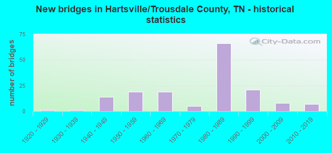
- New bridges - historical statistics
- 11920-1929
- 11930-1939
- 141940-1949
- 191950-1959
- 191960-1969
- 51970-1979
- 661980-1989
- 211990-1999
- 82000-2009
- 72010-2019
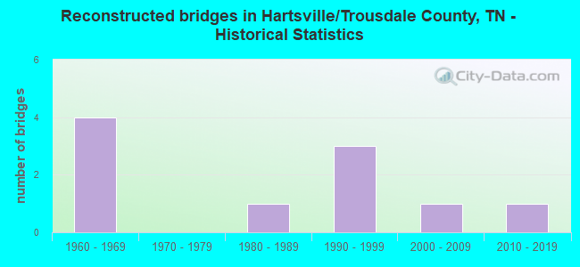
- Reconstructed bridges - Historical Statistics
- 41960-1969
- 01970-1979
- 11980-1989
- 31990-1999
- 12000-2009
- 12010-2019
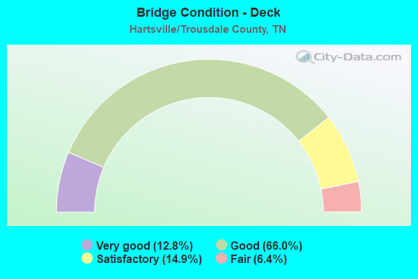
- Bridge Condition - Deck
- 12.8%Very good
- 66.0%Good
- 14.9%Satisfactory
- 6.4%Fair
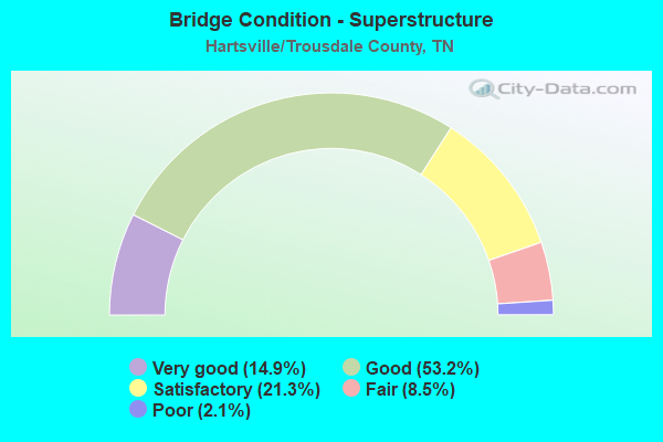
- Bridge Condition - Superstructure
- 14.9%Very good
- 53.2%Good
- 21.3%Satisfactory
- 8.5%Fair
- 2.1%Poor
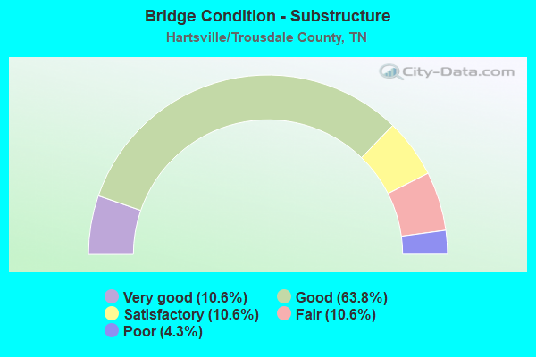
- Bridge Condition - Substructure
- 10.6%Very good
- 63.8%Good
- 10.6%Satisfactory
- 10.6%Fair
- 4.3%Poor
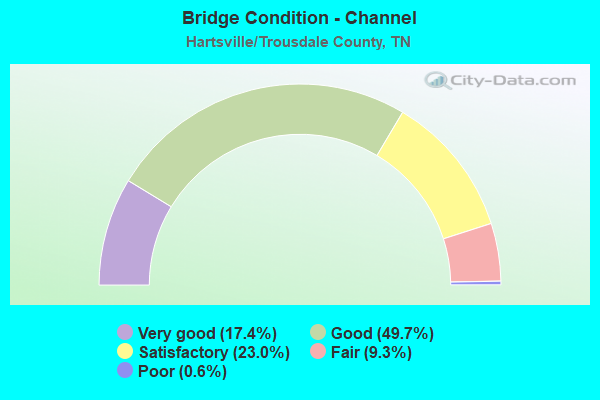
- Bridge Condition - Channel
- 17.4%Very good
- 49.7%Good
- 23.0%Satisfactory
- 9.3%Fair
- 0.6%Poor
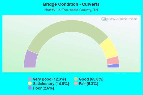
- Bridge Condition - Culverts
- 12.3%Very good
- 65.8%Good
- 14.0%Satisfactory
- 5.3%Fair
- 2.6%Poor
Find on map >> Show street view
Structure Number: 850B1090001, Location: 1.1 M SE JCT SR 141&SR260 (Lat: 36.450775, Lng: -86.253242), Route carried "on" structure: County highway 109, Year Built: 2007, Status: Open, Structure Length: 0.82m (2.69ft), Average Daily Traffic: 420 (year 2022), Truck Traffic: 1%, Average Future Daily Traffic: 672 (year 2041), Design Load: HS 20, Features Intersected: BRANCH
Minimum Vertical Clearance: 30+ m (98+ ft), Kilometerpoint: 0.113, Lanes on structure: 2, Owner: County Highway Agency, Approaching Roadway Width: 7.9m (25.9ft), Material/Design: Concrete continuous, Design/Construction: Culvert, Number Of Spans In Main Unit: 2, Length of Maximum Span: 3.7m (12.1ft), Curb-To-Curb Width: 9.4m (30.8ft), Out-to-Out Width: 10.9m (35.8ft)
Condition: Channel: Satisfactory, Culverts: Good, Operating Rating: 54.1 metric tons, Method Used To Determine Operating Rating: Assigned ratings based on Load and Resistance Factor Design (LRFD) reported by rating factor (RF) using HL93 loadings, Inventory Rating: 32.4 metric tons, Method Used To Determine Inventory Rating: Assigned ratings based on Load and Resistance Factor Design (LRFD) reported by rating factor (RF) using HL93 loadings, Structural Evaluation: Better than present minimum criteria, Deck Geometry: Equal to present minimum criteria, Waterway Adequacy: Better than present minimum criteria, Approach Roadway Alignment: Equal to present desirable criteria, Designated Inspection Frequency: Every 24 months, Inspection Date: Febuary 2021, Deck Structure Type: Concrete Cast-file-Place, Wearing Surface/Protective System: Wearing Surface: Bituminous
Find on map >> Show street view
Structure Number: 850B1300001, Location: 1.1 M SE JCT SR 141&SR260 (Lat: 36.409839, Lng: -86.176483), Route carried "on" structure: County highway 130, Year Built: 1985, Status: Open, Structure Length: 0.82m (2.69ft), Average Daily Traffic: 420 (year 2022), Truck Traffic: 1%, Average Future Daily Traffic: 672 (year 2041), Design Load: HS 20, Features Intersected: LITTLE GOOSE CR OVERFLOW
Minimum Vertical Clearance: 30+ m (98+ ft), Kilometerpoint: 0.039, Lanes on structure: 2, Owner: County Highway Agency, Approaching Roadway Width: 7.9m (25.9ft), Material/Design: Concrete continuous, Design/Construction: Culvert, Number Of Spans In Main Unit: 2, Length of Maximum Span: 3.7m (12.1ft), Curb-To-Curb Width: 9.4m (30.8ft), Out-to-Out Width: 10.9m (35.8ft)
Condition: Channel: Good, Culverts: Good, Operating Rating: 61.2 metric tons, Method Used To Determine Operating Rating: Load Factor (LF), Inventory Rating: 32.4 metric tons, Method Used To Determine Inventory Rating: Load Factor (LF), Structural Evaluation: Better than present minimum criteria, Deck Geometry: Equal to present minimum criteria, Waterway Adequacy: Better than present minimum criteria, Approach Roadway Alignment: Equal to present desirable criteria, Designated Inspection Frequency: Every 24 months, Inspection Date: Febuary 2021, Deck Structure Type: Concrete Cast-file-Place, Wearing Surface/Protective System: Wearing Surface: Bituminous
Find on map >> Show street view
Structure Number: 850B1300003, Location: 1.2 M SE JCT SR 141&SR260 (Lat: 36.408919, Lng: -86.177956), Route carried "on" structure: County highway 130, Year Built: 1985, Status: Open, Structure Length: 4.82m (15.81ft), Average Daily Traffic: 420 (year 2022), Truck Traffic: 1%, Average Future Daily Traffic: 672 (year 2041), Design Load: HS 20, Features Intersected: LITTLE GOOSE CREEK
Minimum Vertical Clearance: 30+ m (98+ ft), Kilometerpoint: 0.200, Lanes on structure: 2, Owner: County Highway Agency, Approaching Roadway Width: 6.7m (22.0ft), Skew: 1 degrees, Material/Design: Prestressed concrete continuous, Design/Construction: Box Beam or Girders - Single/Spread, Number Of Spans In Main Unit: 4, Length of Maximum Span: 11.9m (39.0ft), Curb-To-Curb Width: 9.1m (29.9ft), Out-to-Out Width: 9.9m (32.5ft)
Condition: Deck: Good, Superstructure: Good, Substructure: Good, Channel: Satisfactory, Operating Rating: 66.6 metric tons, Method Used To Determine Operating Rating: Load Factor (LF), Inventory Rating: 27.0 metric tons, Method Used To Determine Inventory Rating: Load Factor (LF), Structural Evaluation: Equal to present minimum criteria, Deck Geometry: Equal to present minimum criteria, Waterway Adequacy: Equal to present minimum criteria, Approach Roadway Alignment: Equal to present desirable criteria, Designated Inspection Frequency: Every 24 months, Inspection Date: Febuary 2021, Deck Structure Type: Concrete Precast Panels, Wearing Surface/Protective System: Wearing Surface: Monolithic Concrete, Deck Protection: Epoxy Coated Reinforcing
Find on map >> Show street view
Structure Number: 85F00070001, Location: 2 MI W OF SMITH CO. (Lat: 36.332400, Lng: -86.137567), Route carried "on" structure: County highway 1070, Year Built: 1986, Status: Open, Structure Length: 1.40m (4.59ft), Average Daily Traffic: 213 (year 2020), Truck Traffic: 3%, Average Future Daily Traffic: 384 (year 2041), Design Load: HS 20, Features Intersected: WARD BRANCH
Minimum Vertical Clearance: 30+ m (98+ ft), Kilometerpoint: 3.178, Lanes on structure: 2, Owner: County Highway Agency, Approaching Roadway Width: 6.4m (21.0ft), Skew: 4 degrees, Material/Design: Concrete continuous, Design/Construction: Culvert, Number Of Spans In Main Unit: 2, Length of Maximum Span: 4.6m (15.1ft), Curb-To-Curb Width: 6.8m (22.3ft), Out-to-Out Width: 7.8m (25.6ft)
Condition: Channel: Good, Culverts: Good, Operating Rating: 89.1 metric tons, Method Used To Determine Operating Rating: Load Factor (LF), Inventory Rating: 32.4 metric tons, Method Used To Determine Inventory Rating: Load Factor (LF), Structural Evaluation: Better than present minimum criteria, Deck Geometry: Meets minimum limits, Waterway Adequacy: Better than present minimum criteria, Approach Roadway Alignment: Equal to present desirable criteria, Designated Inspection Frequency: Every 24 months, Inspection Date: Febuary 2021, Deck Structure Type: Concrete Cast-file-Place, Wearing Surface/Protective System: Wearing Surface: Bituminous
Find on map >> Show street view
Structure Number: 85F00070003, Location: 2 MI W OF SMITH CO. (Lat: 36.330633, Lng: -86.132028), Route carried "on" structure: County highway 1070, Year Built: 1986, Status: Open, Structure Length: 1.13m (3.71ft), Average Daily Traffic: 213 (year 2020), Truck Traffic: 3%, Average Future Daily Traffic: 384 (year 2041), Design Load: HS 20, Features Intersected: STONE BRANCH
Minimum Vertical Clearance: 30+ m (98+ ft), Kilometerpoint: 3.750, Lanes on structure: 2, Owner: County Highway Agency, Approaching Roadway Width: 6.7m (22.0ft), Skew: 4 degrees, Material/Design: Concrete continuous, Design/Construction: Culvert, Number Of Spans In Main Unit: 2, Length of Maximum Span: 3.7m (12.1ft), Curb-To-Curb Width: 6.8m (22.3ft), Out-to-Out Width: 7.8m (25.6ft)
Condition: Channel: Good, Culverts: Good, Operating Rating: 54.9 metric tons, Method Used To Determine Operating Rating: Load Factor (LF), Inventory Rating: 32.4 metric tons, Method Used To Determine Inventory Rating: Load Factor (LF), Structural Evaluation: Better than present minimum criteria, Deck Geometry: Meets minimum limits, Waterway Adequacy: Better than present minimum criteria, Approach Roadway Alignment: Better than present minimum criteria, Designated Inspection Frequency: Every 24 months, Inspection Date: Febuary 2021, Deck Structure Type: Concrete Cast-file-Place, Wearing Surface/Protective System: Wearing Surface: Bituminous
Find on map >> Show street view
Structure Number: 85S61330003, Location: .6 M E JCT SR260&SR376 (Lat: 36.422350, Lng: -86.183250), Route carried "on" structure: State highway 260, Year Built: 2017, Status: Open, Structure Length: 5.12m (16.80ft), Average Daily Traffic: 640 (year 2020), Truck Traffic: 6%, Average Future Daily Traffic: 1,024 (year 2041), Design Load: HL 93, Features Intersected: LITTLE GOOSE CREEK
Minimum Vertical Clearance: 30+ m (98+ ft), Kilometerpoint: 8.980, Lanes on structure: 2, Owner: State Highway Agency, Approaching Roadway Width: 11.0m (36.1ft), Skew: 3 degrees, Material/Design: Prestressed concrete continuous, Design/Construction: Box Beam or Girders - Single/Spread, Number Of Spans In Main Unit: 3, Length of Maximum Span: 15.2m (49.9ft), Curb-To-Curb Width: 10.9m (35.8ft), Out-to-Out Width: 11.5m (37.7ft)
Condition: Deck: Very good, Superstructure: Very good, Substructure: Very good, Channel: Good, Operating Rating: 44.1 metric tons, Method Used To Determine Operating Rating: Assigned ratings based on Load and Resistance Factor Design (LRFD) reported by rating factor (RF) using HL93 loadings, Inventory Rating: 32.4 metric tons, Method Used To Determine Inventory Rating: Assigned ratings based on Load and Resistance Factor Design (LRFD) reported by rating factor (RF) using HL93 loadings, Structural Evaluation: Equal to present desirable criteria, Deck Geometry: Equal to present minimum criteria, Waterway Adequacy: Better than present minimum criteria, Approach Roadway Alignment: Equal to present desirable criteria, Designated Inspection Frequency: Every 24 months, Inspection Date: Febuary 2021, Deck Structure Type: Corrugated Steel, Wearing Surface/Protective System: Wearing Surface: Monolithic Concrete
Find on map >> Show street view
Structure Number: 85S61330009, Location: 4.73 MI W SR-141 (Lat: 36.449583, Lng: -86.253200), Route carried "on" structure: State highway 260, Year Built: 1940, Status: Open, Structure Length: 0.94m (3.08ft), Average Daily Traffic: 339 (year 2020), Truck Traffic: 5%, Average Future Daily Traffic: 542 (year 2041), Design Load: H 15, Features Intersected: BRANCH
Minimum Vertical Clearance: 30+ m (98+ ft), Kilometerpoint: 1.304, Lanes on structure: 2, Owner: State Highway Agency, Approaching Roadway Width: 6.7m (22.0ft), Skew: 4 degrees, Material/Design: Concrete continuous, Design/Construction: Culvert, Number Of Spans In Main Unit: 2, Length of Maximum Span: 3.0m (9.8ft), Curb-To-Curb Width: 6.4m (21.0ft), Out-to-Out Width: 7.0m (23.0ft)
Condition: Channel: Good, Culverts: Satisfactory, Operating Rating: 84.6 metric tons, Method Used To Determine Operating Rating: Load Factor (LF), Inventory Rating: 32.4 metric tons, Method Used To Determine Inventory Rating: Load Factor (LF), Structural Evaluation: Equal to present minimum criteria, Deck Geometry: Meets minimum limits, Waterway Adequacy: Equal to present minimum criteria, Approach Roadway Alignment: Equal to present desirable criteria, Length Of Structure Improvement: 0.94m (3.08ft), Designated Inspection Frequency: Every 24 months, Inspection Date: Febuary 2021, Bridge Improvement Cost: $70,000, Roadway Improvement Cost: $8,000, Total Project Cost: $106,000 ( Estimate for 2021)
Find on map >> Show street view
Structure Number: 85S62890001, Location: 1 MI S OF MACON CO. (Lat: 36.425928, Lng: -86.135256), Route carried "on" structure: County highway 1082, Year Built: 1945, Status: Open, Structure Length: 1.01m (3.31ft), Average Daily Traffic: 1,095 (year 2020), Truck Traffic: 3%, Average Future Daily Traffic: 1,488 (year 2041), Design Load: H 15, Features Intersected: HICKERSON BRANCH
Minimum Vertical Clearance: 30+ m (98+ ft), Kilometerpoint: 4.152, Lanes on structure: 2, Owner: County Highway Agency, Approaching Roadway Width: 6.7m (22.0ft), Material/Design: Concrete continuous, Design/Construction: Culvert, Number Of Spans In Main Unit: 2, Length of Maximum Span: 4.6m (15.1ft), Curb-To-Curb Width: 6.7m (22.0ft), Out-to-Out Width: 7.3m (24.0ft)
Condition: Channel: Good, Culverts: Good, Operating Rating: 89.1 metric tons, Method Used To Determine Operating Rating: Load Factor (LF), Inventory Rating: 32.4 metric tons, Method Used To Determine Inventory Rating: Load Factor (LF), Structural Evaluation: Better than present minimum criteria, Deck Geometry: High priority of corrective action, Waterway Adequacy: Better than present minimum criteria, Approach Roadway Alignment: Equal to present desirable criteria, Length Of Structure Improvement: 1.01m (3.31ft), Designated Inspection Frequency: Every 24 months, Inspection Date: March 2021, Bridge Improvement Cost: $81,000, Roadway Improvement Cost: $9,000, Total Project Cost: $122,000 ( Estimate for 2021), Deck Structure Type: Concrete Cast-file-Place, Wearing Surface/Protective System: Wearing Surface: Bituminous
Find on map >> Show street view
Structure Number: 85S62900001, Location: 0.3 MI E OF SR10 (Lat: 36.391839, Lng: -86.107225), Route carried "on" structure: County highway 1074, Year Built: 1985, Status: Open, Structure Length: 0.82m (2.69ft), Average Daily Traffic: 560 (year 2020), Truck Traffic: 4%, Average Future Daily Traffic: 1,216 (year 2041), Design Load: HS 20, Features Intersected: BRANCH
Minimum Vertical Clearance: 30+ m (98+ ft), Kilometerpoint: 0.515, Lanes on structure: 2, Owner: County Highway Agency, Approaching Roadway Width: 8.5m (27.9ft), Skew: 1 degrees, Material/Design: Concrete continuous, Design/Construction: Culvert, Number Of Spans In Main Unit: 2, Length of Maximum Span: 3.7m (12.1ft), Curb-To-Curb Width: 8.6m (28.2ft), Out-to-Out Width: 9.6m (31.5ft)
Condition: Channel: Satisfactory, Culverts: Satisfactory, Operating Rating: 64.8 metric tons, Method Used To Determine Operating Rating: Load Factor (LF), Inventory Rating: 32.4 metric tons, Method Used To Determine Inventory Rating: Load Factor (LF), Structural Evaluation: Equal to present minimum criteria, Deck Geometry: Somewhat better than minimum adequacy, Waterway Adequacy: Better than present minimum criteria, Approach Roadway Alignment: Equal to present desirable criteria, Designated Inspection Frequency: Every 24 months, Inspection Date: March 2021, Deck Structure Type: Concrete Cast-file-Place, Wearing Surface/Protective System: Wearing Surface: Bituminous
Find on map >> Show street view
Structure Number: 85S62900003, Location: 2 MI N OF SR25 (Lat: 36.385744, Lng: -86.065208), Route carried "on" structure: County highway 1074, Year Built: 1985, Status: Open, Structure Length: 1.19m (3.90ft), Average Daily Traffic: 560 (year 2020), Truck Traffic: 4%, Average Future Daily Traffic: 1,216 (year 2041), Design Load: HS 20, Features Intersected: LICK CREEK
Minimum Vertical Clearance: 30+ m (98+ ft), Kilometerpoint: 4.828, Lanes on structure: 2, Owner: County Highway Agency, Approaching Roadway Width: 7.9m (25.9ft), Material/Design: Concrete continuous, Design/Construction: Culvert, Number Of Spans In Main Unit: 3, Length of Maximum Span: 3.7m (12.1ft)
Condition: Channel: Good, Culverts: Satisfactory, Operating Rating: 45.0 metric tons, Method Used To Determine Operating Rating: Load Factor (LF), Inventory Rating: 26.1 metric tons, Method Used To Determine Inventory Rating: Load Factor (LF), Structural Evaluation: Equal to present minimum criteria, Waterway Adequacy: Better than present minimum criteria, Approach Roadway Alignment: Equal to present desirable criteria, Designated Inspection Frequency: Every 24 months, Inspection Date: March 2021
Find on map >> Show street view
Structure Number: 85S62900005, Location: 2 MI W OF SMITH CO. (Lat: 36.397244, Lng: -86.034214), Route carried "on" structure: County highway 1074, Year Built: 1992, Status: Open, Structure Length: 1.07m (3.51ft), Average Daily Traffic: 324 (year 2020), Truck Traffic: 3%, Average Future Daily Traffic: 528 (year 2041), Design Load: HS 20, Features Intersected: DOG BRANCH
Minimum Vertical Clearance: 30+ m (98+ ft), Kilometerpoint: 8.127, Lanes on structure: 2, Owner: County Highway Agency, Approaching Roadway Width: 6.7m (22.0ft), Skew: 3 degrees, Material/Design: Concrete, Design/Construction: Culvert, Number Of Spans In Main Unit: 1, Length of Maximum Span: 10.4m (34.1ft), Curb-To-Curb Width: 7.9m (25.9ft), Out-to-Out Width: 8.7m (28.5ft)
Condition: Channel: Good, Culverts: Good, Operating Rating: 44.1 metric tons, Method Used To Determine Operating Rating: Assigned rating based on Load Factor Design (LFD) reported in metric tons, Inventory Rating: 32.4 metric tons, Method Used To Determine Inventory Rating: Assigned rating based on Load Factor Design (LFD) reported in metric tons, Structural Evaluation: Better than present minimum criteria, Deck Geometry: Somewhat better than minimum adequacy, Waterway Adequacy: Equal to present minimum criteria, Approach Roadway Alignment: Equal to present desirable criteria, Designated Inspection Frequency: Every 24 months, Inspection Date: March 2021, Deck Structure Type: Concrete Cast-file-Place, Wearing Surface/Protective System: Wearing Surface: Monolithic Concrete, Deck Protection: Epoxy Coated Reinforcing
Find on map >> Show street view
Structure Number: 85SR0100003, Location: 4.5 MI SW OF HARTSVILLE (Lat: 36.390236, Lng: -86.255861), Route carried "on" structure: State highway 10, Year Built: 1952, Status: Open, Structure Length: 0.82m (2.69ft), Average Daily Traffic: 5,185 (year 2020), Truck Traffic: 6%, Average Future Daily Traffic: 8,296 (year 2041), Design Load: H 20, Features Intersected: BRANCH
Minimum Vertical Clearance: 30+ m (98+ ft), Kilometerpoint: 10.638, Lanes on structure: 2, Base Highway Network: Yes, Owner: State Highway Agency, Approaching Roadway Width: 9.1m (29.9ft), Skew: 3 degrees, Material/Design: Concrete continuous, Design/Construction: Culvert, Number Of Spans In Main Unit: 2, Length of Maximum Span: 3.0m (9.8ft)
Condition: Channel: Good, Culverts: Satisfactory, Operating Rating: 36.0 metric tons, Method Used To Determine Operating Rating: Load Factor (LF), Inventory Rating: 22.5 metric tons, Method Used To Determine Inventory Rating: Load Factor (LF), Structural Evaluation: Somewhat better than minimum adequacy, Waterway Adequacy: Better than present minimum criteria, Approach Roadway Alignment: Equal to present desirable criteria, Length Of Structure Improvement: 0.82m (2.69ft), Designated Inspection Frequency: Every 24 months, Inspection Date: Febuary 2021, Bridge Improvement Cost: $253,000, Roadway Improvement Cost: $26,000, Total Project Cost: $380,000 ( Estimate for 2021)
Find on map >> Show street view
Structure Number: 85SR0100005, Location: 4.4 MI SW OF HARTSVILLE (Lat: 36.390117, Lng: -86.254317), Route carried "on" structure: State highway 10, Year Built: 1952, Status: Open, Structure Length: 0.70m (2.30ft), Average Daily Traffic: 5,185 (year 2020), Truck Traffic: 6%, Average Future Daily Traffic: 8,296 (year 2041), Design Load: H 20, Features Intersected: BRANCH
Minimum Vertical Clearance: 30+ m (98+ ft), Kilometerpoint: 10.767, Lanes on structure: 2, Base Highway Network: Yes, Owner: State Highway Agency, Approaching Roadway Width: 9.1m (29.9ft), Material/Design: Concrete continuous, Design/Construction: Culvert, Number Of Spans In Main Unit: 2, Length of Maximum Span: 3.0m (9.8ft)
Condition: Channel: Satisfactory, Culverts: Good, Operating Rating: 39.6 metric tons, Method Used To Determine Operating Rating: Load Factor (LF), Inventory Rating: 25.2 metric tons, Method Used To Determine Inventory Rating: Load Factor (LF), Structural Evaluation: Equal to present minimum criteria, Waterway Adequacy: Better than present minimum criteria, Approach Roadway Alignment: Equal to present desirable criteria, Length Of Structure Improvement: 0.70m (2.30ft), Designated Inspection Frequency: Every 24 months, Inspection Date: Febuary 2021, Bridge Improvement Cost: $166,000, Roadway Improvement Cost: $17,000, Total Project Cost: $250,000 ( Estimate for 2021)
Find on map >> Show street view
Structure Number: 85SR0100007, Location: 4.3 MI SW OF HARTSVILLE (Lat: 36.389900, Lng: -86.251333), Route carried "on" structure: State highway 10, Year Built: 1952, Year Reconstructed: 1994, Status: Open, Structure Length: 2.62m (8.60ft), Average Daily Traffic: 5,185 (year 2020), Truck Traffic: 6%, Average Future Daily Traffic: 8,296 (year 2041), Design Load: H 20, Features Intersected: ROCKY CREEK
Minimum Vertical Clearance: 30+ m (98+ ft), Kilometerpoint: 11.040, Lanes on structure: 2, Base Highway Network: Yes, Owner: State Highway Agency, Approaching Roadway Width: 9.1m (29.9ft), Material/Design: Concrete, Design/Construction: Tee Beam, Number Of Spans In Main Unit: 3, Length of Maximum Span: 8.8m (28.9ft), Curb-To-Curb Width: 10.4m (34.1ft), Out-to-Out Width: 11.0m (36.1ft)
Condition: Deck: Satisfactory, Superstructure: Satisfactory, Substructure: Satisfactory, Channel: Good, Operating Rating: 54.9 metric tons, Method Used To Determine Operating Rating: Load Factor (LF), Inventory Rating: 32.4 metric tons, Method Used To Determine Inventory Rating: Load Factor (LF), Structural Evaluation: Equal to present minimum criteria, Deck Geometry: Meets minimum limits, Waterway Adequacy: Better than present minimum criteria, Approach Roadway Alignment: Equal to present desirable criteria, Designated Inspection Frequency: Every 24 months, Inspection Date: Febuary 2021, Deck Structure Type: Concrete Cast-file-Place, Wearing Surface/Protective System: Wearing Surface: Bituminous
Find on map >> Show street view
Structure Number: 85SR0100009, Location: 1.9 MI W OF HARTSVILLE (Lat: 36.400378, Lng: -86.213472), Route carried "on" structure: State highway 10, Year Built: 1952, Status: Open, Structure Length: 0.85m (2.79ft), Average Daily Traffic: 5,185 (year 2020), Truck Traffic: 6%, Average Future Daily Traffic: 8,296 (year 2041), Design Load: HS 20, Features Intersected: SECOND CREEK
Minimum Vertical Clearance: 30+ m (98+ ft), Kilometerpoint: 14.838, Lanes on structure: 2, Base Highway Network: Yes, Owner: State Highway Agency, Approaching Roadway Width: 9.1m (29.9ft), Skew: 1 degrees, Material/Design: Concrete continuous, Design/Construction: Culvert, Number Of Spans In Main Unit: 2, Length of Maximum Span: 3.7m (12.1ft)
Condition: Channel: Satisfactory, Culverts: Satisfactory, Operating Rating: 86.4 metric tons, Method Used To Determine Operating Rating: Load Factor (LF), Inventory Rating: 32.4 metric tons, Method Used To Determine Inventory Rating: Load Factor (LF), Structural Evaluation: Equal to present minimum criteria, Waterway Adequacy: Better than present minimum criteria, Approach Roadway Alignment: Equal to present desirable criteria, Designated Inspection Frequency: Every 24 months, Inspection Date: Febuary 2021
Find on map >> Show street view
Structure Number: 85SR0100021, Location: 1.7 MI.E.OF HARTSVILLE (Lat: 36.394917, Lng: -86.110633), Route carried "on" structure: State highway 10, Year Built: 1948, Status: Open, Structure Length: 0.70m (2.30ft), Average Daily Traffic: 3,642 (year 2020), Truck Traffic: 7%, Average Future Daily Traffic: 5,827 (year 2041), Design Load: H 15, Features Intersected: BRANCH
Minimum Vertical Clearance: 30+ m (98+ ft), Kilometerpoint: 25.685, Lanes on structure: 2, Base Highway Network: Yes, Owner: State Highway Agency, Approaching Roadway Width: 9.1m (29.9ft), Skew: 1 degrees, Material/Design: Concrete continuous, Design/Construction: Culvert, Number Of Spans In Main Unit: 2, Length of Maximum Span: 3.0m (9.8ft)
Condition: Channel: Good, Culverts: Good, Operating Rating: 26.1 metric tons, Method Used To Determine Operating Rating: Load Factor (LF), Inventory Rating: 24.3 metric tons, Method Used To Determine Inventory Rating: Load Factor (LF), Structural Evaluation: Equal to present minimum criteria, Waterway Adequacy: Equal to present minimum criteria, Approach Roadway Alignment: Equal to present desirable criteria, Designated Inspection Frequency: Every 24 months, Inspection Date: Febuary 2021
Find on map >> Show street view
Structure Number: 85SR0100023, Location: 2.7 MI.E.OF HARTSVILLE (Lat: 36.407333, Lng: -86.102233), Route carried "on" structure: State highway 10, Year Built: 1948, Status: Open, Structure Length: 0.88m (2.89ft), Average Daily Traffic: 3,642 (year 2020), Truck Traffic: 7%, Average Future Daily Traffic: 5,827 (year 2041), Design Load: H 15, Features Intersected: FINLEY BRANCH
Minimum Vertical Clearance: 30+ m (98+ ft), Kilometerpoint: 27.343, Lanes on structure: 2, Base Highway Network: Yes, Owner: State Highway Agency, Approaching Roadway Width: 8.9m (29.2ft), Material/Design: Concrete, Design/Construction: Tee Beam, Number Of Spans In Main Unit: 1, Length of Maximum Span: 8.2m (26.9ft), Curb-To-Curb Width: 8.0m (26.2ft), Out-to-Out Width: 9.2m (30.2ft)
Condition: Deck: Good, Superstructure: Good, Substructure: Good, Channel: Good, Operating Rating: 32.4 metric tons, Method Used To Determine Operating Rating: Load Factor (LF), Inventory Rating: 18.9 metric tons, Method Used To Determine Inventory Rating: Load Factor (LF), Structural Evaluation: Somewhat better than minimum adequacy, Deck Geometry: High priority of corrective action, Waterway Adequacy: Better than present minimum criteria, Approach Roadway Alignment: Equal to present desirable criteria, Length Of Structure Improvement: 0.88m (2.89ft), Designated Inspection Frequency: Every 24 months, Inspection Date: Febuary 2021, Bridge Improvement Cost: $98,000, Roadway Improvement Cost: $10,000, Total Project Cost: $148,000 ( Estimate for 2021), Deck Structure Type: Concrete Cast-file-Place, Wearing Surface/Protective System: Wearing Surface: Bituminous
Find on map >> Show street view
Structure Number: 85SR0100025, Location: 5.3 MI.E. OF HARTSVILLE (Lat: 36.434733, Lng: -86.073333), Route carried "on" structure: State highway 10, Year Built: 1946, Status: Open, Structure Length: 0.88m (2.89ft), Average Daily Traffic: 3,642 (year 2020), Truck Traffic: 7%, Average Future Daily Traffic: 5,827 (year 2041), Design Load: H 15, Features Intersected: PUMPKIN BRANCH
Minimum Vertical Clearance: 30+ m (98+ ft), Kilometerpoint: 31.463, Lanes on structure: 2, Base Highway Network: Yes, Owner: State Highway Agency, Approaching Roadway Width: 9.1m (29.9ft), Skew: 3 degrees, Material/Design: Concrete, Design/Construction: Tee Beam, Number Of Spans In Main Unit: 1, Length of Maximum Span: 8.2m (26.9ft), Curb-To-Curb Width: 8.5m (27.9ft), Out-to-Out Width: 9.1m (29.9ft)
Condition: Deck: Good, Superstructure: Good, Substructure: Good, Channel: Good, Operating Rating: 32.4 metric tons, Method Used To Determine Operating Rating: Load Factor (LF), Inventory Rating: 18.9 metric tons, Method Used To Determine Inventory Rating: Load Factor (LF), Structural Evaluation: Somewhat better than minimum adequacy, Deck Geometry: Meets minimum limits, Waterway Adequacy: Better than present minimum criteria, Approach Roadway Alignment: Equal to present desirable criteria, Length Of Structure Improvement: 0.88m (2.89ft), Designated Inspection Frequency: Every 24 months, Inspection Date: Febuary 2021, Bridge Improvement Cost: $100,000, Roadway Improvement Cost: $11,000, Total Project Cost: $151,000 ( Estimate for 2021), Deck Structure Type: Concrete Cast-file-Place, Wearing Surface/Protective System: Wearing Surface: Bituminous
Find on map >> Show street view
Structure Number: 85SR0102001, Location: NEAR HARTSVILLE (Lat: 36.395467, Lng: -86.264367), Route carried "on" structure: US 231, Year Built: 1943, Status: Open, Structure Length: 0.98m (3.22ft), Average Daily Traffic: 3,784 (year 2020), Truck Traffic: 11%, Average Future Daily Traffic: 6,054 (year 2041), Design Load: H 15, Features Intersected: ROCKY CREEK, Facility Carried by Structure: FAP 376
Minimum Vertical Clearance: 30+ m (98+ ft), Kilometerpoint: 0.789, Lanes on structure: 2, Base Highway Network: Yes, Owner: State Highway Agency, Approaching Roadway Width: 10.4m (34.1ft), Skew: 4 degrees, Material/Design: Concrete continuous, Design/Construction: Culvert, Number Of Spans In Main Unit: 2, Length of Maximum Span: 3.0m (9.8ft)
Condition: Channel: Good, Culverts: Satisfactory, Operating Rating: 89.1 metric tons, Method Used To Determine Operating Rating: Load Factor (LF), Inventory Rating: 32.4 metric tons, Method Used To Determine Inventory Rating: Load Factor (LF), Structural Evaluation: Equal to present minimum criteria, Waterway Adequacy: Better than present minimum criteria, Approach Roadway Alignment: Equal to present desirable criteria, Designated Inspection Frequency: Every 24 months, Inspection Date: Febuary 2021
Find on map >> Show street view
Structure Number: 85SR0102003, Location: NEAR HARTSVILLE (Lat: 36.450617, Lng: -86.267000), Route carried "on" structure: US 231, Year Built: 1940, Status: Open, Structure Length: 2.62m (8.60ft), Average Daily Traffic: 3,239 (year 2020), Truck Traffic: 11%, Average Future Daily Traffic: 5,182 (year 2041), Design Load: H 15, Features Intersected: EAST FORK BLEDSOE CREEK, Facility Carried by Structure: FAP 376
Minimum Vertical Clearance: 30+ m (98+ ft), Kilometerpoint: 6.936, Lanes on structure: 2, Base Highway Network: Yes, Owner: State Highway Agency, Approaching Roadway Width: 10.4m (34.1ft), Material/Design: Concrete, Design/Construction: Tee Beam, Number Of Spans In Main Unit: 3, Length of Maximum Span: 8.8m (28.9ft), Curb-To-Curb Width: 7.3m (24.0ft), Out-to-Out Width: 8.4m (27.6ft)
Condition: Deck: Satisfactory, Superstructure: Fair, Substructure: Good, Channel: Good, Operating Rating: 39.6 metric tons, Method Used To Determine Operating Rating: Load Factor (LF), Inventory Rating: 23.4 metric tons, Method Used To Determine Inventory Rating: Load Factor (LF), Structural Evaluation: Somewhat better than minimum adequacy, Deck Geometry: High priority of replacement, Waterway Adequacy: Better than present minimum criteria, Approach Roadway Alignment: Equal to present desirable criteria, Length Of Structure Improvement: 2.62m (8.60ft), Designated Inspection Frequency: Every 24 months, Inspection Date: Febuary 2021, Bridge Improvement Cost: $279,000, Roadway Improvement Cost: $28,000, Total Project Cost: $419,000 ( Estimate for 2021), Deck Structure Type: Concrete Cast-file-Place, Wearing Surface/Protective System: Wearing Surface: Bituminous
Find on map >> Show street view
Structure Number: 85SR1410007, Location: .25 MI.S.OF HARTSVILLE (Lat: 36.370781, Lng: -86.175906), Route carried "on" structure: State highway 141, Year Built: 1979, Status: Open, Structure Length: 1.04m (3.41ft), Average Daily Traffic: 4,301 (year 2020), Truck Traffic: 4%, Average Future Daily Traffic: 7,104 (year 2041), Design Load: HS 20, Features Intersected: OVERFLOW CUMBERLAND RIVE
Minimum Vertical Clearance: 30+ m (98+ ft), Kilometerpoint: 10.461, Lanes on structure: 2, Owner: State Highway Agency, Approaching Roadway Width: 15.8m (51.8ft), Material/Design: Concrete continuous, Design/Construction: Culvert, Number Of Spans In Main Unit: 2, Length of Maximum Span: 4.6m (15.1ft)
Condition: Channel: Good, Culverts: Poor, Operating Rating: 89.1 metric tons, Method Used To Determine Operating Rating: Load Factor (LF), Inventory Rating: 32.4 metric tons, Method Used To Determine Inventory Rating: Load Factor (LF), Structural Evaluation: Meets minimum limits, Waterway Adequacy: Better than present minimum criteria, Approach Roadway Alignment: Equal to present desirable criteria, Length Of Structure Improvement: 1.04m (3.41ft), Designated Inspection Frequency: Every 24 months, Inspection Date: Febuary 2021, Bridge Improvement Cost: $219,000, Roadway Improvement Cost: $22,000, Total Project Cost: $329,000 ( Estimate for 2021)
Find on map >> Show street view
Structure Number: 95010620001, Location: 5.9 MI NE JCT SR10&SR26 (Lat: 36.283250, Lng: -86.263000), Route carried "on" structure: County highway 1062, Year Built: 1988, Status: Open, Structure Length: 0.79m (2.59ft), Average Daily Traffic: 358 (year 2020), Truck Traffic: 3%, Average Future Daily Traffic: 576 (year 2038), Design Load: HS 20, Features Intersected: WILBORN BRANCH
Minimum Vertical Clearance: 30+ m (98+ ft), Kilometerpoint: 0.901, Lanes on structure: 2, Owner: County Highway Agency, Approaching Roadway Width: 6.1m (20.0ft), Skew: 4 degrees, Material/Design: Concrete continuous, Design/Construction: Culvert, Number Of Spans In Main Unit: 2, Length of Maximum Span: 2.4m (7.9ft), Curb-To-Curb Width: 7.3m (24.0ft), Out-to-Out Width: 8.0m (26.2ft)
Condition: Channel: Very good, Culverts: Good, Operating Rating: 48.6 metric tons, Method Used To Determine Operating Rating: Load Factor (LF), Inventory Rating: 28.8 metric tons, Method Used To Determine Inventory Rating: Load Factor (LF), Structural Evaluation: Better than present minimum criteria, Deck Geometry: Somewhat better than minimum adequacy, Waterway Adequacy: Better than present minimum criteria, Approach Roadway Alignment: Equal to present desirable criteria, Designated Inspection Frequency: Every 24 months, Inspection Date: April 2020, Deck Structure Type: Concrete Cast-file-Place, Wearing Surface/Protective System: Wearing Surface: Monolithic Concrete
Find on map >> Show street view
Structure Number: 950A0890001, Location: ON MITCHELL RD (Lat: 36.298750, Lng: -86.159917), Route carried "on" structure: County highway 89, Year Built: 1985, Status: Open, Structure Length: 1.71m (5.61ft), Average Daily Traffic: 70 (year 2022), Truck Traffic: 1%, Average Future Daily Traffic: 112 (year 2040), Design Load: HS 20, Features Intersected: BRANCH
Minimum Vertical Clearance: 30+ m (98+ ft), Kilometerpoint: 1.339, Lanes on structure: 2, Owner: County Highway Agency, Approaching Roadway Width: 9.8m (32.2ft), Skew: 3 degrees, Material/Design: Concrete continuous, Design/Construction: Culvert, Number Of Spans In Main Unit: 3, Length of Maximum Span: 4.6m (15.1ft), Curb-To-Curb Width: 7.9m (25.9ft), Out-to-Out Width: 8.5m (27.9ft)
Condition: Channel: Very good, Culverts: Good, Operating Rating: 90.9 metric tons, Method Used To Determine Operating Rating: Load Factor (LF), Inventory Rating: 32.4 metric tons, Method Used To Determine Inventory Rating: Load Factor (LF), Structural Evaluation: Better than present minimum criteria, Deck Geometry: Equal to present minimum criteria, Waterway Adequacy: Better than present minimum criteria, Approach Roadway Alignment: Equal to present desirable criteria, Designated Inspection Frequency: Every 24 months, Inspection Date: April 2020, Deck Structure Type: Concrete Cast-file-Place, Wearing Surface/Protective System: Wearing Surface: Bituminous
Find on map >> Show street view
Structure Number: 950A0950001, Location: 1.2 MI WEST OF SR141 (Lat: 36.301217, Lng: -86.219467), Route carried "on" structure: County highway 2039, Year Built: 1965, Status: Posted for load, Structure Length: 7.32m (24.02ft), Average Daily Traffic: 762 (year 2020), Truck Traffic: 3%, Average Future Daily Traffic: 1,184 (year 2041), Features Intersected: CEDAR CREEK
Minimum Vertical Clearance: 30+ m (98+ ft), Kilometerpoint: 2.849, Lanes on structure: 2, Owner: County Highway Agency, Approaching Roadway Width: 6.1m (20.0ft), Skew: 3 degrees, Material/Design: Steel, Design/Construction: Stringer/Multi-beam, Number Of Spans In Main Unit: 12, Length of Maximum Span: 5.8m (19.0ft), Curb-To-Curb Width: 5.5m (18.0ft), Out-to-Out Width: 5.9m (19.4ft)
Condition: Deck: Satisfactory, Superstructure: Fair, Substructure: Fair, Channel: Satisfactory, Operating Rating: 12.3 metric tons, Method Used To Determine Operating Rating: Load and Resistance Factor Rating (LRFR) rating reported by rating factor(RF) method using HL-93 loadings, Inventory Rating: 9.4 metric tons, Method Used To Determine Inventory Rating: Load and Resistance Factor Rating (LRFR) rating reported by rating factor(RF) method using HL-93 loadings, Structural Evaluation: High priority of replacement, Deck Geometry: High priority of replacement, Waterway Adequacy: Equal to present minimum criteria, Approach Roadway Alignment: Equal to present minimum criteria, Bridge Posting: Required (Relationship of Operating Rating to Maximum Legal Load: 10.0 - 19.9% below), Length Of Structure Improvement: 8.35m (27.40ft), Designated Inspection Frequency: Every 24 months, Inspection Date: April 2020, Bridge Improvement Cost: $1,525,000, Roadway Improvement Cost: $153,000, Total Project Cost: $2,288,000 ( Estimate for 2021), Deck Structure Type: Concrete Cast-file-Place, Wearing Surface/Protective System: Wearing Surface: Monolithic Concrete
Find on map >> Show street view
Structure Number: 950A1860001, Location: NEAR SR141 ON JOHNSON RD (Lat: 36.290233, Lng: -86.207217), Route carried "on" structure: County highway 186, Year Built: 1993, Status: Open, Structure Length: 0.91m (2.99ft), Average Daily Traffic: 250 (year 2022), Truck Traffic: 2%, Average Future Daily Traffic: 400 (year 2038), Design Load: HS 20, Features Intersected: BRANCH
Minimum Vertical Clearance: 30+ m (98+ ft), Kilometerpoint: 2.282, Lanes on structure: 2, Owner: County Highway Agency, Approaching Roadway Width: 7.6m (24.9ft), Skew: 4 degrees, Material/Design: Concrete continuous, Design/Construction: Culvert, Number Of Spans In Main Unit: 2, Length of Maximum Span: 3.0m (9.8ft), Curb-To-Curb Width: 7.5m (24.6ft), Out-to-Out Width: 9.2m (30.2ft)
Condition: Channel: Very good, Culverts: Satisfactory, Operating Rating: 64.8 metric tons, Method Used To Determine Operating Rating: Load Factor (LF), Inventory Rating: 32.4 metric tons, Method Used To Determine Inventory Rating: Load Factor (LF), Structural Evaluation: Equal to present minimum criteria, Deck Geometry: Somewhat better than minimum adequacy, Waterway Adequacy: Better than present minimum criteria, Approach Roadway Alignment: Equal to present desirable criteria, Designated Inspection Frequency: Every 24 months, Inspection Date: April 2020, Wearing Surface/Protective System: Wearing Surface: Bituminous
Find on map >> Show street view
Structure Number: 950A1950001, Location: 1.2 MI EAST OF SR141 (Lat: 36.277483, Lng: -86.185983), Route carried "on" structure: County highway 195, Year Built: 1965, Year Reconstructed: 1990, Status: Open, Structure Length: 0.66m (2.17ft), Average Daily Traffic: 150 (year 2022), Truck Traffic: 2%, Average Future Daily Traffic: 240 (year 2041), Features Intersected: CLENDENON BRANCH
Minimum Vertical Clearance: 30+ m (98+ ft), Kilometerpoint: 5.345, Lanes on structure: 2, Owner: County Highway Agency, Approaching Roadway Width: 6.1m (20.0ft), Skew: 1 degrees, Material/Design: Concrete continuous, Design/Construction: Culvert, Number Of Spans In Main Unit: 2, Length of Maximum Span: 3.0m (9.8ft), Curb-To-Curb Width: 8.5m (27.9ft), Out-to-Out Width: 9.1m (29.9ft)
Condition: Channel: Good, Culverts: Good, Operating Rating: 35.1 metric tons, Method Used To Determine Operating Rating: Load Factor (LF), Inventory Rating: 22.5 metric tons, Method Used To Determine Inventory Rating: Load Factor (LF), Structural Evaluation: Equal to present minimum criteria, Deck Geometry: Equal to present minimum criteria, Waterway Adequacy: Better than present minimum criteria, Approach Roadway Alignment: Equal to present desirable criteria, Designated Inspection Frequency: Every 24 months, Inspection Date: April 2020, Deck Structure Type: Concrete Cast-file-Place, Wearing Surface/Protective System: Wearing Surface: Monolithic Concrete
Find on map >> Show street view
Structure Number: 950A1950003, Location: 1.5 MI WEST OF SMITH CO (Lat: 36.282533, Lng: -86.156617), Route carried "on" structure: County highway 195, Year Built: 1950, Year Reconstructed: 1990, Status: Open, Structure Length: 0.70m (2.30ft), Average Daily Traffic: 120 (year 2022), Truck Traffic: 2%, Average Future Daily Traffic: 192 (year 2040), Features Intersected: CLENDENON BRANCH
Minimum Vertical Clearance: 30+ m (98+ ft), Kilometerpoint: 9.495, Lanes on structure: 2, Owner: County Highway Agency, Approaching Roadway Width: 6.1m (20.0ft), Skew: 2 degrees, Material/Design: Concrete continuous, Design/Construction: Culvert, Number Of Spans In Main Unit: 2, Length of Maximum Span: 3.0m (9.8ft), Curb-To-Curb Width: 8.5m (27.9ft), Out-to-Out Width: 9.1m (29.9ft)
Condition: Channel: Satisfactory, Culverts: Satisfactory, Operating Rating: 38.7 metric tons, Method Used To Determine Operating Rating: Load Factor (LF), Inventory Rating: 22.5 metric tons, Method Used To Determine Inventory Rating: Load Factor (LF), Structural Evaluation: Equal to present minimum criteria, Deck Geometry: Equal to present minimum criteria, Waterway Adequacy: Equal to present minimum criteria, Approach Roadway Alignment: Equal to present desirable criteria, Designated Inspection Frequency: Every 24 months, Inspection Date: April 2020, Deck Structure Type: Concrete Cast-file-Place, Wearing Surface/Protective System: Wearing Surface: Monolithic Concrete
Find on map >> Show street view
Structure Number: 950A2970001, Location: 5.2 MI NW JCT SR10&SR26 (Lat: 36.291417, Lng: -86.295633), Route carried "on" structure: County highway 297, Year Built: 1986, Status: Open, Structure Length: 1.77m (5.81ft), Average Daily Traffic: 230 (year 2022), Truck Traffic: 1%, Average Future Daily Traffic: 368 (year 2038), Design Load: HS 20, Features Intersected: GRAVES BRANCH
Minimum Vertical Clearance: 30+ m (98+ ft), Kilometerpoint: 1.091, Lanes on structure: 2, Owner: County Highway Agency, Approaching Roadway Width: 7.9m (25.9ft), Material/Design: Concrete continuous, Design/Construction: Culvert, Number Of Spans In Main Unit: 3, Length of Maximum Span: 5.5m (18.0ft), Curb-To-Curb Width: 8.5m (27.9ft), Out-to-Out Width: 9.3m (30.5ft)
Condition: Channel: Very good, Culverts: Very good, Operating Rating: 71.1 metric tons, Method Used To Determine Operating Rating: Load Factor (LF), Inventory Rating: 32.4 metric tons, Method Used To Determine Inventory Rating: Load Factor (LF), Structural Evaluation: Equal to present desirable criteria, Deck Geometry: Equal to present minimum criteria, Waterway Adequacy: Better than present minimum criteria, Approach Roadway Alignment: Equal to present desirable criteria, Designated Inspection Frequency: Every 24 months, Inspection Date: April 2020, Deck Structure Type: Concrete Cast-file-Place, Wearing Surface/Protective System: Wearing Surface: Bituminous
Find on map >> Show street view
Structure Number: 950A2970003, Location: ON BURFORD RD (Lat: 36.284800, Lng: -86.279000), Route carried "on" structure: County highway 297, Year Built: 1980, Status: Open, Structure Length: 1.19m (3.90ft), Average Daily Traffic: 230 (year 2022), Truck Traffic: 1%, Average Future Daily Traffic: 368 (year 2040), Design Load: HS 20, Features Intersected: BRANCH
Minimum Vertical Clearance: 30+ m (98+ ft), Kilometerpoint: 3.399, Lanes on structure: 2, Owner: County Highway Agency, Approaching Roadway Width: 6.7m (22.0ft), Skew: 1 degrees, Material/Design: Concrete continuous, Design/Construction: Culvert, Number Of Spans In Main Unit: 3, Length of Maximum Span: 3.7m (12.1ft), Curb-To-Curb Width: 8.4m (27.6ft), Out-to-Out Width: 8.8m (28.9ft)
Condition: Channel: Good, Culverts: Good, Operating Rating: 42.3 metric tons, Method Used To Determine Operating Rating: Load Factor (LF), Inventory Rating: 26.1 metric tons, Method Used To Determine Inventory Rating: Load Factor (LF), Structural Evaluation: Equal to present minimum criteria, Deck Geometry: Somewhat better than minimum adequacy, Waterway Adequacy: Equal to present minimum criteria, Approach Roadway Alignment: Equal to present desirable criteria, Designated Inspection Frequency: Every 24 months, Inspection Date: April 2020, Deck Structure Type: Concrete Cast-file-Place, Wearing Surface/Protective System: Wearing Surface: Bituminous
Find on map >> Show street view
Structure Number: 950A7180001, Location: 2.0 MI EAST OF SR10 (Lat: 36.290717, Lng: -86.235633), Route carried "on" structure: County highway 718, Year Built: 1960, Year Reconstructed: 1990, Status: Open, Structure Length: 0.91m (2.99ft), Average Daily Traffic: 410 (year 2022), Truck Traffic: 2%, Average Future Daily Traffic: 656 (year 2040), Features Intersected: BRANCH
Minimum Vertical Clearance: 30+ m (98+ ft), Kilometerpoint: 3.325, Lanes on structure: 2, Owner: County Highway Agency, Approaching Roadway Width: 5.5m (18.0ft), Skew: 3 degrees, Material/Design: Concrete continuous, Design/Construction: Culvert, Number Of Spans In Main Unit: 2, Length of Maximum Span: 3.7m (12.1ft), Curb-To-Curb Width: 8.2m (26.9ft), Out-to-Out Width: 8.6m (28.2ft)
Condition: Channel: Satisfactory, Culverts: Very good, Operating Rating: 45.0 metric tons, Method Used To Determine Operating Rating: Load Factor (LF), Inventory Rating: 25.2 metric tons, Method Used To Determine Inventory Rating: Load Factor (LF), Structural Evaluation: Equal to present minimum criteria, Deck Geometry: Somewhat better than minimum adequacy, Waterway Adequacy: Equal to present minimum criteria, Approach Roadway Alignment: Equal to present desirable criteria, Designated Inspection Frequency: Every 24 months, Inspection Date: April 2020, Deck Structure Type: Concrete Cast-file-Place, Wearing Surface/Protective System: Wearing Surface: Gravel
Find on map >> Show street view
Structure Number: 950A7180003, Location: 0.8 MI WEST OF SR141 (Lat: 36.291900, Lng: -86.223317), Route carried "on" structure: County highway 718, Year Built: 1945, Year Reconstructed: 1965, Status: Posted for load, Structure Length: 0.76m (2.49ft), Average Daily Traffic: 410 (year 2022), Truck Traffic: 2%, Average Future Daily Traffic: 656 (year 2040), Features Intersected: NANCY BRANCH
Minimum Vertical Clearance: 30+ m (98+ ft), Kilometerpoint: 4.699, Lanes on structure: 2, Owner: County Highway Agency, Approaching Roadway Width: 7.0m (23.0ft), Skew: 1 degrees, Material/Design: Steel, Design/Construction: Stringer/Multi-beam, Number Of Spans In Main Unit: 1, Length of Maximum Span: 7.0m (23.0ft), Curb-To-Curb Width: 7.8m (25.6ft), Out-to-Out Width: 8.3m (27.2ft)
Condition: Deck: Good, Superstructure: Poor, Substructure: Good, Channel: Good, Operating Rating: 8.1 metric tons, Method Used To Determine Operating Rating: Load and Resistance Factor Rating (LRFR) rating reported by rating factor(RF) method using HL-93 loadings, Inventory Rating: 6.2 metric tons, Method Used To Determine Inventory Rating: Load and Resistance Factor Rating (LRFR) rating reported by rating factor(RF) method using HL-93 loadings, Structural Evaluation: High priority of corrective action, Deck Geometry: Meets minimum limits, Waterway Adequacy: Somewhat better than minimum adequacy, Approach Roadway Alignment: Equal to present desirable criteria, Bridge Posting: Required (Relationship of Operating Rating to Maximum Legal Load: 10.0 - 19.9% below), Length Of Structure Improvement: 0.76m (2.49ft), Designated Inspection Frequency: Every 24 months, Inspection Date: April 2020, Bridge Improvement Cost: $50,000, Roadway Improvement Cost: $6,000, Total Project Cost: $76,000 ( Estimate for 2020), Deck Structure Type: Corrugated Steel, Wearing Surface/Protective System: Wearing Surface: Bituminous
Find on map >> Show street view
Structure Number: 950A7190001, Location: 1.3 MI EAST OF SR141 (Lat: 36.275100, Lng: -86.202133), Route carried "on" structure: County highway 719, Year Built: 1986, Status: Open, Structure Length: 3.96m (12.99ft), Average Daily Traffic: 630 (year 2022), Truck Traffic: 2%, Average Future Daily Traffic: 1,008 (year 2042), Design Load: HS 20, Features Intersected: CEDAR CREEK
Minimum Vertical Clearance: 30+ m (98+ ft), Kilometerpoint: 2.350, Lanes on structure: 2, Owner: County Highway Agency, Approaching Roadway Width: 3.7m (12.1ft), Skew: 2 degrees, Material/Design: Prestressed concrete, Design/Construction: Stringer/Multi-beam, Number Of Spans In Main Unit: 3, Length of Maximum Span: 13.4m (44.0ft), Curb-To-Curb Width: 7.9m (25.9ft), Out-to-Out Width: 9.0m (29.5ft)
Condition: Deck: Good, Superstructure: Good, Substructure: Satisfactory, Channel: Very good, Operating Rating: 45.0 metric tons, Method Used To Determine Operating Rating: Load and Resistance Factor Rating (LRFR) rating reported by rating factor(RF) method using HL-93 loadings, Inventory Rating: 34.7 metric tons, Method Used To Determine Inventory Rating: Load and Resistance Factor Rating (LRFR) rating reported by rating factor(RF) method using HL-93 loadings, Structural Evaluation: Equal to present minimum criteria, Deck Geometry: Somewhat better than minimum adequacy, Waterway Adequacy: Better than present minimum criteria, Approach Roadway Alignment: Equal to present minimum criteria, Designated Inspection Frequency: Every 24 months, Inspection Date: April 2020, Deck Structure Type: Concrete Cast-file-Place, Wearing Surface/Protective System: Wearing Surface: Monolithic Concrete
Find on map >> Show street view
Structure Number: 95SR0100015, Location: 1.5 M SW TROUSDALE CO LN (Lat: 36.280533, Lng: -86.275233), Route carried "on" structure: US 231, Year Built: 1955, Status: Open, Structure Length: 7.41m (24.31ft), Average Daily Traffic: 7,193 (year 2020), Truck Traffic: 11%, Average Future Daily Traffic: 13,376 (year 2040), Design Load: HS 20, Features Intersected: SPRING CREEK, Facility Carried by Structure: FAP 10
Minimum Vertical Clearance: 30+ m (98+ ft), Kilometerpoint: 31.342, Lanes on structure: 2, Base Highway Network: Yes, Owner: State Highway Agency, Approaching Roadway Width: 9.1m (29.9ft), Skew: 1 degrees, Material/Design: Concrete, Design/Construction: Tee Beam, Number Of Spans In Main Unit: 7, Length of Maximum Span: 13.1m (43.0ft), Curb-To-Curb Width: 7.9m (25.9ft), Out-to-Out Width: 9.9m (32.5ft)
Condition: Deck: Good, Superstructure: Good, Substructure: Good, Channel: Good, Operating Rating: 53.1 metric tons, Method Used To Determine Operating Rating: Load Factor (LF), Inventory Rating: 32.4 metric tons, Method Used To Determine Inventory Rating: Load Factor (LF), Structural Evaluation: Better than present minimum criteria, Deck Geometry: High priority of corrective action, Waterway Adequacy: Equal to present minimum criteria, Approach Roadway Alignment: Equal to present desirable criteria, Length Of Structure Improvement: 7.41m (24.31ft), Designated Inspection Frequency: Every 24 months, Inspection Date: November 2021, Bridge Improvement Cost: $685,000, Roadway Improvement Cost: $69,000, Total Project Cost: $1,028,000 ( Estimate for 2020), Deck Structure Type: Concrete Cast-file-Place, Wearing Surface/Protective System: Wearing Surface: Bituminous
Find on map >> Show street view
Structure Number: 95SR0100017, Location: IS WILSON-TROUSDALE LINE (Lat: 36.298700, Lng: -86.263467), Route carried "on" structure: US 231, Year Built: 1991, Status: Open, Structure Length: 26.76m (87.80ft), Average Daily Traffic: 7,193 (year 2020), Truck Traffic: 11%, Average Future Daily Traffic: 13,808 (year 2040), Design Load: HS 20, Features Intersected: CUMBERLAND RIVER, Facility Carried by Structure: FAP 10
Minimum Vertical Clearance: 30+ m (98+ ft), Kilometerpoint: 33.652, Lanes on structure: 2, Base Highway Network: Yes, Owner: State Highway Agency, Approaching Roadway Width: 14.6m (47.9ft), Navigation Control: Yes ( Vertical Clearance: 16.1m (52.8ft), Horizontal Clearance: 108.2m (355.0ft)), Material/Design: Steel continuous, Design/Construction: Stringer/Multi-beam, Number Of Spans In Main Unit: 3, Length of Maximum Span: 132.6m (435.0ft), Curb-To-Curb Width: 14.6m (47.9ft), Out-to-Out Width: 15.2m (49.9ft)
Condition: Deck: Good, Superstructure: Good, Substructure: Poor, Channel: Very good, Operating Rating: 51.3 metric tons, Method Used To Determine Operating Rating: Load Factor (LF), Inventory Rating: 30.6 metric tons, Method Used To Determine Inventory Rating: Load Factor (LF), Structural Evaluation: Meets minimum limits, Deck Geometry: Superior to present desirable criteria, Waterway Adequacy: Better than present minimum criteria, Approach Roadway Alignment: Equal to present desirable criteria, Length Of Structure Improvement: 26.76m (87.80ft), Designated Inspection Frequency: Every 24 months, Underwater Inspection Frequency: Every 60 months, Inspection Date: March 2020, Underwater Inspection Date: September 2017, Bridge Improvement Cost: $14,117,000, Roadway Improvement Cost: $1,412,000, Total Project Cost: $21,176,000 ( Estimate for 2020), Deck Structure Type: Concrete Precast Panels, Wearing Surface/Protective System: Wearing Surface: Monolithic Concrete, Deck Protection: Epoxy Coated Reinforcing
Find on map >> Show street view
Structure Number: 95SR1410003, Location: 3.4 M SW TROUSDALE CO LN (Lat: 36.289917, Lng: -86.206167), Route carried "on" structure: State highway 141, Year Built: 2016, Status: Open, Structure Length: 1.62m (5.31ft), Average Daily Traffic: 4,570 (year 2020), Truck Traffic: 7%, Average Future Daily Traffic: 6,656 (year 2040), Design Load: HL 93, Features Intersected: BRANCH
Minimum Vertical Clearance: 30+ m (98+ ft), Kilometerpoint: 5.246, Lanes on structure: 2, Base Highway Network: Yes, Owner: State Highway Agency, Approaching Roadway Width: 14.0m (45.9ft), Skew: 4 degrees, Material/Design: Concrete continuous, Design/Construction: Culvert, Number Of Spans In Main Unit: 3, Length of Maximum Span: 3.7m (12.1ft)
Condition: Channel: Very good, Culverts: Very good, Operating Rating: 54.1 metric tons, Method Used To Determine Operating Rating: Assigned ratings based on Load and Resistance Factor Design (LRFD) reported by rating factor (RF) using HL93 loadings, Inventory Rating: 32.4 metric tons, Method Used To Determine Inventory Rating: Assigned ratings based on Load and Resistance Factor Design (LRFD) reported by rating factor (RF) using HL93 loadings, Structural Evaluation: Equal to present desirable criteria, Waterway Adequacy: Equal to present minimum criteria, Approach Roadway Alignment: Equal to present desirable criteria, Designated Inspection Frequency: Every 24 months, Inspection Date: March 2020
Find on map >> Show street view
Structure Number: 95SR1410005, Location: 3.5 M SW TROUSDALE CO LN (Lat: 36.289183, Lng: -86.207850), Route carried "on" structure: State highway 141, Year Built: 2016, Status: Open, Structure Length: 6.83m (22.41ft), Average Daily Traffic: 6,497 (year 2020), Truck Traffic: 7%, Average Future Daily Traffic: 10,192 (year 2040), Design Load: HL 93, Features Intersected: CEDAR CREEK
Minimum Vertical Clearance: 30+ m (98+ ft), Kilometerpoint: 5.432, Lanes on structure: 2, Base Highway Network: Yes, Owner: State Highway Agency, Approaching Roadway Width: 14.3m (46.9ft), Material/Design: Prestressed concrete, Design/Construction: Stringer/Multi-beam, Number Of Spans In Main Unit: 3, Length of Maximum Span: 22.9m (75.1ft), Curb-To-Curb Width: 14.3m (46.9ft), Out-to-Out Width: 15.0m (49.2ft)
Condition: Deck: Very good, Superstructure: Very good, Substructure: Very good, Channel: Very good, Operating Rating: 44.1 metric tons, Method Used To Determine Operating Rating: Assigned ratings based on Load and Resistance Factor Design (LRFD) reported by rating factor (RF) using HL93 loadings, Inventory Rating: 32.4 metric tons, Method Used To Determine Inventory Rating: Assigned ratings based on Load and Resistance Factor Design (LRFD) reported by rating factor (RF) using HL93 loadings, Structural Evaluation: Equal to present desirable criteria, Deck Geometry: Superior to present desirable criteria, Waterway Adequacy: Better than present minimum criteria, Approach Roadway Alignment: Equal to present desirable criteria, Designated Inspection Frequency: Every 24 months, Inspection Date: March 2020, Deck Structure Type: Concrete Cast-file-Place, Wearing Surface/Protective System: Wearing Surface: Bituminous