Bridge Statistics for Hartford, Connecticut (CT)
Condition, Traffic, Stress, Structural Evaluation, Project Costs
- National Bridge Inventory (NBI) Statistics
- 229Number of bridges
- 5,407ft / 1,648mTotal length
- $147,465,000Total costs
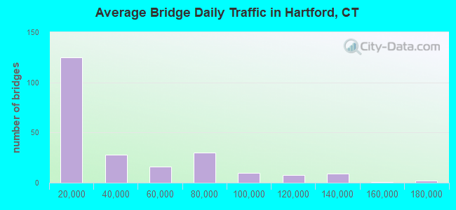
- 8,379,506Total average daily traffic
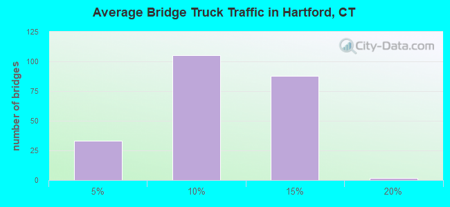
- 936,650Total average daily truck traffic
- National Bridge Inventory (NBI) Registered Bridges for Hartford
- No street view available for this location
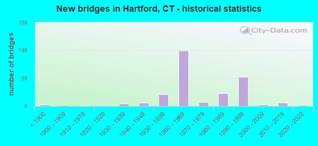
- New bridges - historical statistics
- 3Before 1900
- 21900-1909
- 11910-1919
- 41930-1939
- 61940-1949
- 211950-1959
- 991960-1969
- 71970-1979
- 231980-1989
- 521990-1999
- 32000-2009
- 62010-2019
- 22020-2022
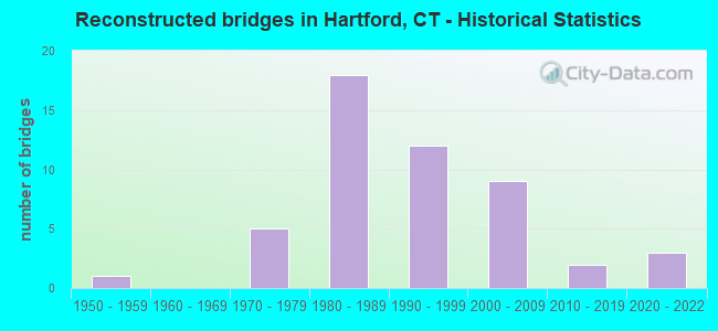
- Reconstructed bridges - Historical Statistics
- 11950-1959
- 01960-1969
- 51970-1979
- 181980-1989
- 121990-1999
- 92000-2009
- 22010-2019
- 32020-2022
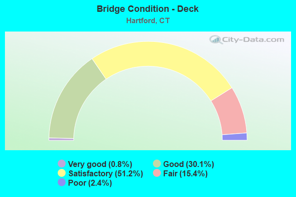
- Bridge Condition - Deck
- 0.8%Very good
- 30.1%Good
- 51.2%Satisfactory
- 15.4%Fair
- 2.4%Poor
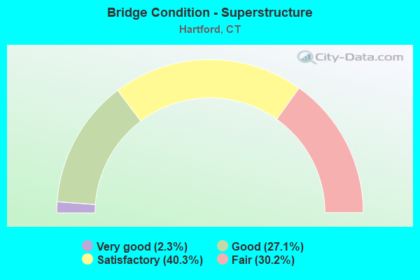
- Bridge Condition - Superstructure
- 2.3%Very good
- 27.1%Good
- 40.3%Satisfactory
- 30.2%Fair
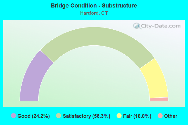
- Bridge Condition - Substructure
- 24.2%Very good
- 56.3%Good
- 18.0%Satisfactory
- 1.6%Fair
- 0.8%Poor
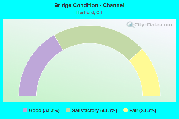
- Bridge Condition - Channel
- 33.3%Good
- 43.3%Satisfactory
- 23.3%Fair
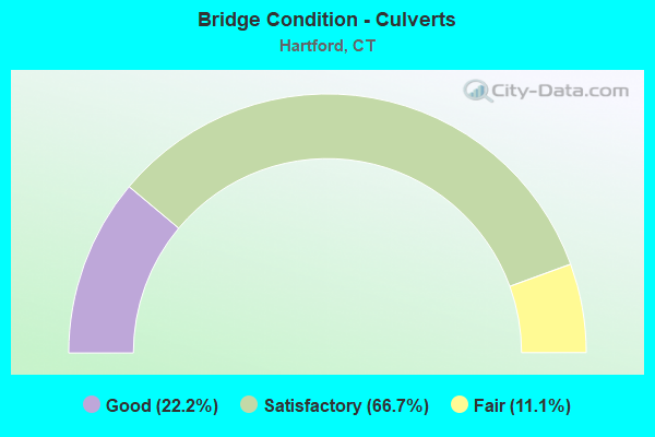
- Bridge Condition - Culverts
- 22.2%Good
- 66.7%Satisfactory
- 11.1%Fair
Find on map >> Show street view
Structure Number: 1764, Location: BR AT INT OF I-84 EB (Lat: 41.768133, Lng: -72.683919), Route carried "under" structure: Interstate 84, Year Built: 1966, Structure Length: 0. m, Average Daily Traffic: 76,350 (year 2015), Truck Traffic: 9%, Features Intersected: I-84 WESTBOUND, Facility Carried by Structure: ASYLUM STREET
Minimum Vertical Clearance: 6.15m (20.18ft), Kilometerpoint: 99.184, Lanes on structure: 6, Lanes under structure: 4, Material/Design: Steel, Design/Construction: Stringer/Multi-beam, Length of Maximum Span: 24.4m (80.1ft)
Find on map >> Show street view
Structure Number: 1855, Location: 0.1 MI W OF JCT I-91 (Lat: 41.760750, Lng: -72.668053), Route carried "under" structure: State highway 598, Year Built: 1964, Structure Length: 0. m, Average Daily Traffic: 34,900 (year 2019), Truck Traffic: 8%, Features Intersected: SR 598, Facility Carried by Structure: COMMERCE STREET
Minimum Vertical Clearance: 5.21m (17.09ft), Kilometerpoint: 0.676, Lanes on structure: 2, Lanes under structure: 6, Material/Design: Steel continuous, Design/Construction: Girder and Floorbeam System, Length of Maximum Span: 41.6m (136.5ft)
Find on map >> Show street view
Structure Number: 1863, Location: RAMP FROM SR598 TO I91 NB (Lat: 41.760469, Lng: -72.666022), Route carried "under" structure: Ramp Interstate 598, Year Built: 1964, Structure Length: 0. m, Average Daily Traffic: 6,800 (year 2019), Truck Traffic: 14%, Features Intersected: SR 598 WB &CONN SOUTHERN
Minimum Vertical Clearance: 4.65m (15.26ft), Kilometerpoint: 0.837, Lanes on structure: 1, Lanes under structure: 2, Material/Design: Steel continuous, Design/Construction: Stringer/Multi-beam, Length of Maximum Span: 20.7m (67.9ft)
Find on map >> Show street view
Structure Number: 3301, Location: 1.17 MI S OF JCT US 44 WB (Lat: 41.766456, Lng: -72.685725), Route carried "under" structure: Ramp Interstate 84, Year Built: 1966, Structure Length: 0. m, Average Daily Traffic: 17,200 (year 2015), Truck Traffic: 9%, Features Intersected: BROAD ST, I-84 RAMP 191
Minimum Vertical Clearance: 7.62m (25.00ft), Kilometerpoint: 0.499, Lanes on structure: 3, Lanes under structure: 1, Material/Design: Steel, Design/Construction: Stringer/Multi-beam, Length of Maximum Span: 28.7m (94.2ft)
Find on map >> Show street view
Structure Number: 3302, Location: .5MI W OF HIGH ST & I84WB (Lat: 41.766736, Lng: -72.686325), Route carried "under" structure: Interstate 84, Year Built: 1966, Structure Length: 0. m, Average Daily Traffic: 73,600 (year 2018), Truck Traffic: 14%, Features Intersected: I-84 WB & I-84 RAMP 191, Facility Carried by Structure: BROAD STREET
Minimum Vertical Clearance: 5.36m (17.59ft), Kilometerpoint: 98.910, Lanes on structure: 5, Lanes under structure: 4, Material/Design: Steel, Design/Construction: Stringer/Multi-beam, Length of Maximum Span: 38.1m (125.0ft)
Find on map >> Show street view
Structure Number: 3302, Location: .5MI W OF HIGH ST & I84WB (Lat: 41.766736, Lng: -72.686325), Route carried "under" structure: Ramp Interstate 84, Year Built: 1966, Structure Length: 0. m, Average Daily Traffic: 9,900 (year 2014), Truck Traffic: 14%, Features Intersected: I-84 WB & I-84 RAMP 191, Facility Carried by Structure: BROAD STREET
Minimum Vertical Clearance: 4.37m (14.34ft), Kilometerpoint: 98.878, Lanes on structure: 5, Lanes under structure: 1, Material/Design: Steel, Design/Construction: Stringer/Multi-beam, Length of Maximum Span: 38.1m (125.0ft)
Find on map >> Show street view
Structure Number: 3305, Location: CAPITOL AVE RAMP TO 84 WB (Lat: 41.766250, Lng: -72.683586), Route carried "under" structure: Ramp Interstate 84, Year Built: 1966, Structure Length: 0. m, Average Daily Traffic: 5,600 (year 2018), Truck Traffic: 14%, Features Intersected: INTERSTATE 84 RAMP 191, Facility Carried by Structure: AMTRAK
Minimum Vertical Clearance: 5.00m (16.40ft), Kilometerpoint: 0.370, Lanes under structure: 1, Material/Design: Steel, Design/Construction: Girder and Floorbeam System, Length of Maximum Span: 24.7m (81.0ft)
Find on map >> Show street view
Structure Number: 3367, Location: NEW PARK AV,AMTRAK,SR504 (Lat: 41.749478, Lng: -72.708800), Route carried "under" structure: Ramp State highway 504, Year Built: 1967, Structure Length: 0. m, Average Daily Traffic: 10,600 (year 2018), Truck Traffic: 8%, Features Intersected: NEW PARK AV,AMTRAK,SR504, Facility Carried by Structure: INTERSTATE-84 EAST
Minimum Vertical Clearance: 5.03m (16.50ft), Kilometerpoint: 0.933, Lanes on structure: 3, Lanes under structure: 1, Material/Design: Steel, Design/Construction: Stringer/Multi-beam, Length of Maximum Span: 37.5m (123.0ft)
Find on map >> Show street view
Structure Number: 3385, Location: CAPITOL AVE RAMP TO I84WB (Lat: 41.766175, Lng: -72.683483), Route carried "under" structure: Ramp Interstate 84, Year Built: 1966, Structure Length: 0. m, Average Daily Traffic: 5,600 (year 2018), Truck Traffic: 7%, Features Intersected: I-84 RAMP 191, Facility Carried by Structure: PEDESTRIAN WALKWAY
Minimum Vertical Clearance: 4.34m (14.24ft), Kilometerpoint: 0.354, Lanes under structure: 1, Material/Design: Steel, Design/Construction: Stringer/Multi-beam, Length of Maximum Span: 23.7m (77.8ft)
Find on map >> Show street view
Structure Number: 3400C, Location: RAMP I-84EB TO SISSON AVE (Lat: 41.760506, Lng: -72.699889), Route carried "under" structure: Interstate 84, Year Built: 1969, Structure Length: 0. m, Average Daily Traffic: 67,200 (year 2018), Truck Traffic: 14%, Features Intersected: I84,503,RR,CAP AV,FOREST
Minimum Vertical Clearance: 8.71m (28.58ft), Kilometerpoint: 97.591, Lanes on structure: 1, Lanes under structure: 3, Material/Design: Steel, Design/Construction: Stringer/Multi-beam, Length of Maximum Span: 41.1m (134.8ft)
Find on map >> Show street view
Structure Number: 3400C, Location: RAMP I-84EB TO SISSON AVE (Lat: 41.760506, Lng: -72.699889), Route carried "under" structure: Ramp State highway 503, Year Built: 1969, Structure Length: 0. m, Average Daily Traffic: 20,600 (year 2018), Truck Traffic: 4%, Features Intersected: I84,503,RR,CAP AV,FOREST, Facility Carried by Structure: I-84 TR 823
Minimum Vertical Clearance: 5.16m (16.93ft), Kilometerpoint: 0.612, Lanes on structure: 1, Lanes under structure: 1, Material/Design: Steel, Design/Construction: Stringer/Multi-beam, Length of Maximum Span: 41.1m (134.8ft)
Find on map >> Show street view
Structure Number: 3401B, Location: .26 MILES S OF JCT I-84WB (Lat: 41.761089, Lng: -72.698881), Route carried "under" structure: Interstate 84, Year Built: 1969, Structure Length: 0. m, Average Daily Traffic: 130,600 (year 2018), Truck Traffic: 9%, Features Intersected: I-84&AMTRAK&LOCAL RDS, Facility Carried by Structure: SR 503 EASTBOUND
Minimum Vertical Clearance: 5.51m (18.08ft), Kilometerpoint: 97.671, Lanes on structure: 1, Lanes under structure: 6, Material/Design: Steel, Design/Construction: Stringer/Multi-beam, Length of Maximum Span: 32.3m (106.0ft)
Find on map >> Show street view
Structure Number: 4295, Location: EB ON RAMP FROM BROAD ST (Lat: 41.766583, Lng: -72.684544), Route carried "under" structure: Ramp Interstate 84, Year Built: 1979, Structure Length: 0. m, Average Daily Traffic: 9,900 (year 2018), Truck Traffic: 14%, Features Intersected: I-84 WB EXIT 48 ON RAMP
Minimum Vertical Clearance: 12.50m (41.01ft), Kilometerpoint: 0.451, Lanes on structure: 1, Lanes under structure: 2, Material/Design: Steel continuous, Design/Construction: Stringer/Multi-beam, Length of Maximum Span: 38.1m (125.0ft)
Find on map >> Show street view
Structure Number: 5654, Location: LEGISLATIVE OFFICE BLDG. (Lat: 41.763858, Lng: -72.683842), Route carried "under" structure: Ramp Interstate 84, Year Built: 1987, Structure Length: 0. m, Average Daily Traffic: 8,015 (year 2017), Truck Traffic: 3%, Features Intersected: I-84 CAPITOL AVE. RAMPS, Facility Carried by Structure: PEDESTRIAN WALKWAY
Minimum Vertical Clearance: 5.18m (16.99ft), Kilometerpoint: 0.563, Lanes under structure: 3, Material/Design: Steel, Design/Construction: Stringer/Multi-beam, Length of Maximum Span: 21.6m (70.9ft)
Find on map >> Show street view
Structure Number: 5654, Location: LEGISLATIVE OFFICE BLDG. (Lat: 41.763858, Lng: -72.683842), Route carried "under" structure: Ramp Interstate 84, Year Built: 1987, Structure Length: 0. m, Average Daily Traffic: 7,075 (year 2017), Truck Traffic: 3%, Features Intersected: I-84 CAPITOL AVE. RAMPS, Facility Carried by Structure: PEDESTRIAN WALKWAY
Minimum Vertical Clearance: 5.00m (16.40ft), Kilometerpoint: 0.644, Lanes under structure: 1, Material/Design: Steel, Design/Construction: Stringer/Multi-beam, Length of Maximum Span: 21.6m (70.9ft)
Find on map >> Show street view
Structure Number: 5762, Location: I-84 EB EXIT 48A OFF RAMP (Lat: 41.766236, Lng: -72.684186), Route carried "under" structure: Ramp Interstate 84, Year Built: 1987, Structure Length: 0. m, Average Daily Traffic: 10,600 (year 2014), Truck Traffic: 7%, Features Intersected: I-84 RAMP 191 & 06871T
Minimum Vertical Clearance: 4.88m (16.01ft), Kilometerpoint: 0.000, Lanes on structure: 1, Lanes under structure: 1, Material/Design: Steel continuous, Design/Construction: Stringer/Multi-beam, Length of Maximum Span: 43.6m (143.0ft)
Find on map >> Show street view
Structure Number: 5865, Location: .4 MI NO OF I-84/91 INTER (Lat: 41.787464, Lng: -72.657575), Route carried "under" structure: Interstate 91, Year Built: 1989, Structure Length: 0. m, Average Daily Traffic: 133,900 (year 2015), Truck Traffic: 14%, Features Intersected: INTERSTATE-91, Facility Carried by Structure: JENNINGS ROAD
Minimum Vertical Clearance: 5.59m (18.34ft), Kilometerpoint: 64.148, Lanes on structure: 6, Lanes under structure: 11, Material/Design: Steel continuous, Design/Construction: Box Beam or Girders - Single/Spread, Length of Maximum Span: 43.6m (143.0ft)
Find on map >> Show street view
Structure Number: 5867, Location: 0.26 MILES NORTH OF I-84 (Lat: 41.773247, Lng: -72.668458), Route carried "under" structure: Ramp Interstate 91, Year Built: 1990, Structure Length: 0. m, Average Daily Traffic: 33,700 (year 2015), Truck Traffic: 9%, Features Intersected: I-91 & TR 826, 839, 841, Facility Carried by Structure: PEDESTRIAN WALKWAY
Minimum Vertical Clearance: 5.44m (17.85ft), Kilometerpoint: 0.000, Lanes under structure: 1, Material/Design: Steel continuous, Design/Construction: Stringer/Multi-beam, Length of Maximum Span: 71.9m (235.9ft)
Find on map >> Show street view
Structure Number: 5867, Location: 0.26 MILES NORTH OF I-84 (Lat: 41.773247, Lng: -72.668458), Route carried "under" structure: Interstate 91, Year Built: 1990, Structure Length: 0. m, Average Daily Traffic: 90,400 (year 2015), Truck Traffic: 9%, Features Intersected: I-91 & TR 826, 839, 841, Facility Carried by Structure: PEDESTRIAN WALKWAY
Minimum Vertical Clearance: 6.83m (22.41ft), Kilometerpoint: 62.282, Lanes under structure: 16, Material/Design: Steel continuous, Design/Construction: Stringer/Multi-beam, Length of Maximum Span: 71.9m (235.9ft)
Find on map >> Show street view
Structure Number: 5867, Location: 0.26 MILES NORTH OF I-84 (Lat: 41.773247, Lng: -72.668458), Route carried "under" structure: Ramp Interstate 91, Year Built: 1990, Structure Length: 0. m, Average Daily Traffic: 12,200 (year 2015), Truck Traffic: 9%, Features Intersected: I-91 & TR 826, 839, 841, Facility Carried by Structure: PEDESTRIAN WALKWAY
Minimum Vertical Clearance: 5.66m (18.57ft), Kilometerpoint: 0.000, Lanes under structure: 1, Material/Design: Steel continuous, Design/Construction: Stringer/Multi-beam, Length of Maximum Span: 71.9m (235.9ft)
Find on map >> Show street view
Structure Number: 5867, Location: 0.26 MILES NORTH OF I-84 (Lat: 41.773247, Lng: -72.668458), Route carried "under" structure: Ramp Interstate 91, Year Built: 1990, Structure Length: 0. m, Average Daily Traffic: 68,400 (year 2015), Truck Traffic: 9%, Features Intersected: I-91 & TR 826, 839, 841, Facility Carried by Structure: PEDESTRIAN WALKWAY
Minimum Vertical Clearance: 6.17m (20.24ft), Kilometerpoint: 0.000, Lanes under structure: 1, Material/Design: Steel continuous, Design/Construction: Stringer/Multi-beam, Length of Maximum Span: 71.9m (235.9ft)
Find on map >> Show street view
Structure Number: 5868, Location: FLY-OVER (Lat: 41.769792, Lng: -72.668603), Route carried "under" structure: US 44, Year Built: 1990, Structure Length: 0. m, Average Daily Traffic: 21,500 (year 2018), Truck Traffic: 6%, Features Intersected: I-84/91 RAMPS, CSO RR, Facility Carried by Structure: W-N TURNING RDWY
Minimum Vertical Clearance: 30+ m (98+ ft), Kilometerpoint: 86.357, Lanes on structure: 1, Lanes under structure: 3, Material/Design: Steel continuous, Design/Construction: Box Beam or Girders - Single/Spread, Length of Maximum Span: 68.0m (223.1ft)
Find on map >> Show street view
Structure Number: 5868, Location: FLY-OVER (Lat: 41.769792, Lng: -72.668603), Route carried "under" structure: Ramp Interstate 84, Year Built: 1990, Structure Length: 0. m, Average Daily Traffic: 9,800 (year 2018), Truck Traffic: 9%, Features Intersected: I-84/91 RAMPS, CSO RR, Facility Carried by Structure: W-N TURNING RDWY
Minimum Vertical Clearance: 6.99m (22.93ft), Kilometerpoint: 0.000, Lanes on structure: 1, Lanes under structure: 1, Material/Design: Steel continuous, Design/Construction: Box Beam or Girders - Single/Spread, Length of Maximum Span: 68.0m (223.1ft)
Find on map >> Show street view
Structure Number: 5868, Location: FLY-OVER (Lat: 41.769792, Lng: -72.668603), Route carried "under" structure: Ramp Interstate 91, Year Built: 1990, Structure Length: 0. m, Average Daily Traffic: 5,200 (year 2018), Truck Traffic: 9%, Features Intersected: I-84/91 RAMPS, CSO RR, Facility Carried by Structure: W-N TURNING RDWY
Minimum Vertical Clearance: 12.19m (39.99ft), Kilometerpoint: 61.944, Lanes on structure: 1, Lanes under structure: 2, Material/Design: Steel continuous, Design/Construction: Box Beam or Girders - Single/Spread, Length of Maximum Span: 68.0m (223.1ft)
Find on map >> Show street view
Structure Number: 5868, Location: FLY-OVER (Lat: 41.769792, Lng: -72.668603), Route carried "under" structure: Ramp Interstate 91, Year Built: 1990, Structure Length: 0. m, Average Daily Traffic: 1,100 (year 2020), Truck Traffic: 9%, Features Intersected: I-84/91 RAMPS, CSO RR, Facility Carried by Structure: W-N TURNING RDWY
Minimum Vertical Clearance: 5.39m (17.68ft), Kilometerpoint: 61.944, Lanes on structure: 1, Lanes under structure: 1, Material/Design: Steel continuous, Design/Construction: Box Beam or Girders - Single/Spread, Length of Maximum Span: 68.0m (223.1ft)
Find on map >> Show street view
Structure Number: 5868, Location: FLY-OVER (Lat: 41.769792, Lng: -72.668603), Route carried "under" structure: Ramp Interstate 91, Year Built: 1990, Structure Length: 0. m, Average Daily Traffic: 17,000 (year 2018), Truck Traffic: 13%, Features Intersected: I-84/91 RAMPS, CSO RR, Facility Carried by Structure: W-N TURNING RDWY
Minimum Vertical Clearance: 5.89m (19.32ft), Kilometerpoint: 61.944, Lanes on structure: 1, Lanes under structure: 1, Material/Design: Steel continuous, Design/Construction: Box Beam or Girders - Single/Spread, Length of Maximum Span: 68.0m (223.1ft)
Find on map >> Show street view
Structure Number: 5868, Location: FLY-OVER (Lat: 41.769792, Lng: -72.668603), Route carried "under" structure: Ramp Interstate 84, Year Built: 1990, Structure Length: 0. m, Average Daily Traffic: 15,800 (year 2018), Truck Traffic: 14%, Features Intersected: I-84/91 RAMPS, CSO RR, Facility Carried by Structure: W-N TURNING RDWY
Minimum Vertical Clearance: 7.62m (25.00ft), Kilometerpoint: 0.000, Lanes on structure: 1, Lanes under structure: 1, Material/Design: Steel continuous, Design/Construction: Box Beam or Girders - Single/Spread, Length of Maximum Span: 68.0m (223.1ft)
Find on map >> Show street view
Structure Number: 5868, Location: FLY-OVER (Lat: 41.769792, Lng: -72.668603), Route carried "under" structure: Ramp Interstate 91, Year Built: 1990, Structure Length: 0. m, Average Daily Traffic: 81,900 (year 2018), Truck Traffic: 14%, Features Intersected: I-84/91 RAMPS, CSO RR, Facility Carried by Structure: W-N TURNING RDWY
Minimum Vertical Clearance: 7.62m (25.00ft), Kilometerpoint: 61.799, Lanes on structure: 1, Lanes under structure: 4, Material/Design: Steel continuous, Design/Construction: Box Beam or Girders - Single/Spread, Length of Maximum Span: 68.0m (223.1ft)
Find on map >> Show street view
Structure Number: 5868, Location: FLY-OVER (Lat: 41.769792, Lng: -72.668603), Route carried "under" structure: Interstate 84, Year Built: 1990, Structure Length: 0. m, Average Daily Traffic: 89,900 (year 2018), Truck Traffic: 14%, Features Intersected: I-84/91 RAMPS, CSO RR, Facility Carried by Structure: W-N TURNING RDWY
Minimum Vertical Clearance: 8.23m (27.00ft), Kilometerpoint: 100.584, Lanes on structure: 1, Lanes under structure: 4, Material/Design: Steel continuous, Design/Construction: Box Beam or Girders - Single/Spread, Length of Maximum Span: 68.0m (223.1ft)
Find on map >> Show street view
Structure Number: 592, Location: SO END OF BR CHAPEL ST SO (Lat: 41.771097, Lng: -72.678908), Route carried "under" structure: Interstate 84, Year Built: 1988, Structure Length: 0. m, Average Daily Traffic: 165,900 (year 2018), Truck Traffic: 14%, Features Intersected: INTERSTATE 84 & RAMPS, Facility Carried by Structure: HIGH STREET
Minimum Vertical Clearance: 5.36m (17.59ft), Kilometerpoint: 99.763, Lanes on structure: 3, Lanes under structure: 8, Material/Design: Steel continuous, Design/Construction: Stringer/Multi-beam, Length of Maximum Span: 26.8m (87.9ft)
Find on map >> Show street view
Structure Number: 5921, Location: I-91 SB EXIT 32A TO 84 WB (Lat: 41.770794, Lng: -72.669511), Route carried "under" structure: Ramp Interstate 91, Year Built: 1990, Structure Length: 0. m, Average Daily Traffic: 5,200 (year 2015), Truck Traffic: 14%, Features Intersected: I-91 RAMP 186
Minimum Vertical Clearance: 5.44m (17.85ft), Kilometerpoint: 0.000, Lanes on structure: 1, Lanes under structure: 3, Material/Design: Steel, Design/Construction: Stringer/Multi-beam, Length of Maximum Span: 30.8m (101.0ft)
Find on map >> Show street view
Structure Number: 5922, Location: .54 MI NO OF SR 530 (Lat: 41.745539, Lng: -72.660678), Route carried "under" structure: US 5, Year Built: 1990, Structure Length: 0. m, Average Daily Traffic: 36,800 (year 2015), Truck Traffic: 9%, Features Intersected: US5, RTE 15 & I-91 TR861, Facility Carried by Structure: INTERSTATE-91 NB
Minimum Vertical Clearance: 5.59m (18.34ft), Kilometerpoint: 54.235, Lanes on structure: 3, Lanes under structure: 4, Material/Design: Steel continuous, Design/Construction: Stringer/Multi-beam, Length of Maximum Span: 76.2m (250.0ft)
Find on map >> Show street view
Structure Number: 5922, Location: .54 MI NO OF SR 530 (Lat: 41.745539, Lng: -72.660678), Route carried "under" structure: Ramp Interstate 91, Year Built: 1990, Structure Length: 0. m, Average Daily Traffic: 19,900 (year 2012), Truck Traffic: 8%, Features Intersected: US5, RTE 15 & I-91 TR861
Minimum Vertical Clearance: 5.13m (16.83ft), Kilometerpoint: 0.000, Lanes on structure: 3, Lanes under structure: 2, Material/Design: Steel continuous, Design/Construction: Stringer/Multi-beam, Length of Maximum Span: 76.2m (250.0ft)
Find on map >> Show street view
Structure Number: 5925, Location: RAMPS FROM 91 NB&SB TO 84 (Lat: 41.769922, Lng: -72.670900), Route carried "under" structure: US 44, Year Built: 1990, Structure Length: 0. m, Average Daily Traffic: 7,300 (year 2018), Truck Traffic: 6%, Features Intersected: U.S. 44 WB & MARKET ST, Facility Carried by Structure: I-84/91 TR841/858
Minimum Vertical Clearance: 4.93m (16.17ft), Kilometerpoint: 86.309, Lanes on structure: 2, Lanes under structure: 3, Material/Design: Steel, Design/Construction: Stringer/Multi-beam, Length of Maximum Span: 40.2m (131.9ft)
Find on map >> Show street view
Structure Number: 6000A, Location: 0.3 MI NORTH OF I-91 NB (Lat: 41.752967, Lng: -72.654031), Route carried "under" structure: Ramp State highway 15, Year Built: 1991, Structure Length: 0. m, Average Daily Traffic: 29,000 (year 2020), Truck Traffic: 8%, Features Intersected: I-91 NB,RT 2,CT RIVER,RR
Minimum Vertical Clearance: 5.49m (18.01ft), Kilometerpoint: 131.162, Lanes on structure: 2, Lanes under structure: 2, Material/Design: Steel continuous, Design/Construction: Box Beam or Girders - Multiple, Length of Maximum Span: 93.0m (305.1ft)
Find on map >> Show street view
Structure Number: 6000A, Location: 0.3 MI NORTH OF I-91 NB (Lat: 41.752967, Lng: -72.654031), Route carried "under" structure: State highway 2, Year Built: 1991, Structure Length: 0. m, Average Daily Traffic: 74,600 (year 2018), Truck Traffic: 8%, Features Intersected: I-91 NB,RT 2,CT RIVER,RR, Facility Carried by Structure: ROUTE 15 NORTHBOUN
Minimum Vertical Clearance: 7.62m (25.00ft), Kilometerpoint: 2.350, Lanes on structure: 2, Lanes under structure: 7, Material/Design: Steel continuous, Design/Construction: Box Beam or Girders - Multiple, Length of Maximum Span: 93.0m (305.1ft)
Find on map >> Show street view
Structure Number: 6000A, Location: 0.3 MI NORTH OF I-91 NB (Lat: 41.752967, Lng: -72.654031), Route carried "under" structure: Interstate 91, Year Built: 1991, Structure Length: 0. m, Average Daily Traffic: 56,200 (year 2015), Truck Traffic: 9%, Features Intersected: I-91 NB,RT 2,CT RIVER,RR, Facility Carried by Structure: ROUTE 15 NORTHBOUN
Minimum Vertical Clearance: 5.26m (17.26ft), Kilometerpoint: 59.514, Lanes on structure: 2, Lanes under structure: 3, Material/Design: Steel continuous, Design/Construction: Box Beam or Girders - Multiple, Length of Maximum Span: 93.0m (305.1ft)
Find on map >> Show street view
Structure Number: 6000B, Location: 0.3 MI NORTH OF I-91 NB (Lat: 41.753122, Lng: -72.654181), Route carried "under" structure: State highway 2, Year Built: 1991, Structure Length: 0. m, Average Daily Traffic: 74,500 (year 2015), Truck Traffic: 6%, Features Intersected: I-91 NB,RT 2,CT RIVER,RR, Facility Carried by Structure: ROUTE 15 SOUTHBOUN
Minimum Vertical Clearance: 7.49m (24.57ft), Kilometerpoint: 2.285, Lanes on structure: 3, Lanes under structure: 7, Material/Design: Steel continuous, Design/Construction: Stringer/Multi-beam, Length of Maximum Span: 93.0m (305.1ft)
Find on map >> Show street view
Structure Number: 6000B, Location: 0.3 MI NORTH OF I-91 NB (Lat: 41.753122, Lng: -72.654181), Route carried "under" structure: Interstate 91, Year Built: 1991, Structure Length: 0. m, Average Daily Traffic: 54,650 (year 2015), Truck Traffic: 9%, Features Intersected: I-91 NB,RT 2,CT RIVER,RR, Facility Carried by Structure: ROUTE 15 SOUTHBOUN
Minimum Vertical Clearance: 5.64m (18.50ft), Kilometerpoint: 59.626, Lanes on structure: 3, Lanes under structure: 5, Material/Design: Steel continuous, Design/Construction: Stringer/Multi-beam, Length of Maximum Span: 93.0m (305.1ft)
Find on map >> Show street view
Structure Number: 6047, Location: .24 MI W OF O-PASS RTE 44 (Lat: 41.770564, Lng: -72.677286), Route carried "under" structure: Ramp Interstate 84, Year Built: 1991, Structure Length: 0. m, Average Daily Traffic: 3,000 (year 2018), Truck Traffic: 3%, Features Intersected: INTERSTATE-84 & RAMPS, Facility Carried by Structure: ANN UCCELLO STREET
Minimum Vertical Clearance: 5.03m (16.50ft), Kilometerpoint: 0.000, Lanes on structure: 5, Lanes under structure: 1, Material/Design: Steel continuous, Design/Construction: Stringer/Multi-beam, Length of Maximum Span: 26.8m (87.9ft)
Find on map >> Show street view
Structure Number: 6047, Location: .24 MI W OF O-PASS RTE 44 (Lat: 41.770564, Lng: -72.677286), Route carried "under" structure: Interstate 84, Year Built: 1991, Structure Length: 0. m, Average Daily Traffic: 160,300 (year 2018), Truck Traffic: 19%, Features Intersected: INTERSTATE-84 & RAMPS, Facility Carried by Structure: ANN UCCELLO STREET
Minimum Vertical Clearance: 5.79m (19.00ft), Kilometerpoint: 99.892, Lanes on structure: 5, Lanes under structure: 10, Material/Design: Steel continuous, Design/Construction: Stringer/Multi-beam, Length of Maximum Span: 26.8m (87.9ft)
Find on map >> Show street view
Structure Number: 6047, Location: .24 MI W OF O-PASS RTE 44 (Lat: 41.770564, Lng: -72.677286), Route carried "under" structure: Ramp Interstate 84, Year Built: 1991, Structure Length: 0. m, Average Daily Traffic: 2,600 (year 2018), Truck Traffic: 3%, Features Intersected: INTERSTATE-84 & RAMPS, Facility Carried by Structure: ANN UCCELLO STREET
Minimum Vertical Clearance: 4.98m (16.34ft), Kilometerpoint: 0.000, Lanes on structure: 5, Lanes under structure: 1, Material/Design: Steel continuous, Design/Construction: Stringer/Multi-beam, Length of Maximum Span: 26.8m (87.9ft)
Find on map >> Show street view
Structure Number: 6048, Location: AT WEST END BULKELEY BRG (Lat: 41.769667, Lng: -72.668403), Route carried "under" structure: Ramp Interstate 91, Year Built: 1989, Structure Length: 0. m, Average Daily Traffic: 18,100 (year 2018), Truck Traffic: 14%, Features Intersected: I-91 NB, C-D RDWY & RAMP, Facility Carried by Structure: US ROUTE 44 WB
Minimum Vertical Clearance: 5.00m (16.40ft), Kilometerpoint: 0.000, Lanes on structure: 2, Lanes under structure: 1, Material/Design: Steel, Design/Construction: Stringer/Multi-beam, Length of Maximum Span: 17.1m (56.1ft)
Find on map >> Show street view
Structure Number: 6048, Location: AT WEST END BULKELEY BRG (Lat: 41.769667, Lng: -72.668403), Route carried "under" structure: Interstate 91, Year Built: 1989, Structure Length: 0. m, Average Daily Traffic: 28,900 (year 2018), Truck Traffic: 14%, Features Intersected: I-91 NB, C-D RDWY & RAMP, Facility Carried by Structure: US ROUTE 44 WB
Minimum Vertical Clearance: 5.21m (17.09ft), Kilometerpoint: 61.895, Lanes on structure: 2, Lanes under structure: 2, Material/Design: Steel, Design/Construction: Stringer/Multi-beam, Length of Maximum Span: 17.1m (56.1ft)
Find on map >> Show street view
Structure Number: 6048, Location: AT WEST END BULKELEY BRG (Lat: 41.769667, Lng: -72.668403), Route carried "under" structure: Ramp Interstate 91, Year Built: 1989, Structure Length: 0. m, Average Daily Traffic: 13,700 (year 2018), Truck Traffic: 14%, Features Intersected: I-91 NB, C-D RDWY & RAMP, Facility Carried by Structure: US ROUTE 44 WB
Minimum Vertical Clearance: 5.13m (16.83ft), Kilometerpoint: 0.563, Lanes on structure: 2, Lanes under structure: 2, Material/Design: Steel, Design/Construction: Stringer/Multi-beam, Length of Maximum Span: 17.1m (56.1ft)
Find on map >> Show street view
Structure Number: 6049, Location: ACCESS 84EB FROM MORGANST (Lat: 41.769342, Lng: -72.668272), Route carried "under" structure: Ramp Interstate 91, Year Built: 1989, Structure Length: 0. m, Average Daily Traffic: 18,100 (year 2018), Truck Traffic: 5%, Features Intersected: I-91 NB,I-91 COL,SW RDWY, Facility Carried by Structure: US ROUTE 44 EB
Minimum Vertical Clearance: 5.72m (18.77ft), Kilometerpoint: 0.000, Lanes on structure: 2, Lanes under structure: 1, Material/Design: Steel, Design/Construction: Stringer/Multi-beam, Length of Maximum Span: 14.6m (47.9ft)
Find on map >> Show street view
Structure Number: 6049, Location: ACCESS 84EB FROM MORGANST (Lat: 41.769342, Lng: -72.668272), Route carried "under" structure: Interstate 91, Year Built: 1989, Structure Length: 0. m, Average Daily Traffic: 28,900 (year 2018), Truck Traffic: 14%, Features Intersected: I-91 NB,I-91 COL,SW RDWY, Facility Carried by Structure: US ROUTE 44 EB
Minimum Vertical Clearance: 5.79m (19.00ft), Kilometerpoint: 61.863, Lanes on structure: 2, Lanes under structure: 2, Material/Design: Steel, Design/Construction: Stringer/Multi-beam, Length of Maximum Span: 14.6m (47.9ft)
Find on map >> Show street view
Structure Number: 6049, Location: ACCESS 84EB FROM MORGANST (Lat: 41.769342, Lng: -72.668272), Route carried "under" structure: Ramp Interstate 91, Year Built: 1989, Structure Length: 0. m, Average Daily Traffic: 13,700 (year 2018), Truck Traffic: 14%, Features Intersected: I-91 NB,I-91 COL,SW RDWY, Facility Carried by Structure: US ROUTE 44 EB
Minimum Vertical Clearance: 5.97m (19.59ft), Kilometerpoint: 61.799, Lanes on structure: 2, Lanes under structure: 2, Material/Design: Steel, Design/Construction: Stringer/Multi-beam, Length of Maximum Span: 14.6m (47.9ft)
Find on map >> Show street view
Structure Number: 6555, Location: 400' SOUTH OF FOUNDERS BR (Lat: 41.764542, Lng: -72.667475), Route carried "under" structure: Ramp Interstate 91, Year Built: 1998, Structure Length: 0. m, Average Daily Traffic: 2,100 (year 2015), Truck Traffic: 14%, Features Intersected: I-91 NORTHBOUND RAMP 188
Minimum Vertical Clearance: 5.11m (16.77ft), Kilometerpoint: 61.332, Lanes on structure: 9, Lanes under structure: 1, Material/Design: Concrete, Design/Construction: Frame, Length of Maximum Span: 14.3m (46.9ft)
Find on map >> Show street view
Structure Number: 6556, Location: 400' SOUTH OF FOUNDERS BR (Lat: 41.764722, Lng: -72.667794), Route carried "under" structure: Ramp Interstate 91, Year Built: 1998, Structure Length: 0. m, Average Daily Traffic: 1,700 (year 2015), Truck Traffic: 14%, Features Intersected: I-84 ACCESS RAMP 331
Minimum Vertical Clearance: 4.90m (16.08ft), Kilometerpoint: 61.364, Lanes on structure: 4, Lanes under structure: 1, Material/Design: Concrete, Design/Construction: Frame, Length of Maximum Span: 23.8m (78.1ft)
Find on map >> Show street view
Structure Number: 6870T, Location: JUNC BUSWAY & CAPITOL AVE (Lat: 41.766269, Lng: -72.683739), Route carried "under" structure: Ramp Interstate 84, Year Built: 2015, Structure Length: 0. m, Average Daily Traffic: 7,062 (year 2015), Truck Traffic: 6%, Features Intersected: I-84 WB CAPITOL AVE RAMP, Facility Carried by Structure: NB BUSWAY
Minimum Vertical Clearance: 5.94m (19.49ft), Kilometerpoint: 0.322, Lanes on structure: 1, Lanes under structure: 1, Material/Design: Steel, Design/Construction: Stringer/Multi-beam, Length of Maximum Span: 32.7m (107.3ft)
Find on map >> Show street view
Structure Number: 6871T, Location: JUNC BUSWAY & CAPITOL AVE (Lat: 41.766464, Lng: -72.683700), Route carried "under" structure: Ramp Interstate 84, Year Built: 2015, Structure Length: 0. m, Average Daily Traffic: 7,062 (year 2015), Truck Traffic: 6%, Features Intersected: I-84 WB CAPITOL AVE, Facility Carried by Structure: SB BUSWAY
Minimum Vertical Clearance: 5.18m (16.99ft), Kilometerpoint: 0.322, Lanes on structure: 1, Lanes under structure: 1, Material/Design: Steel, Design/Construction: Stringer/Multi-beam, Length of Maximum Span: 23.9m (78.4ft)
Find on map >> Show street view
Structure Number: 6947, Location: I-91 NORTHBOUND, EXIT 29 (Lat: 41.746961, Lng: -72.660419), Route carried "under" structure: US 5, Year Built: 2021, Structure Length: 0. m, Average Daily Traffic: 18,600 (year 2019), Truck Traffic: 8%, Features Intersected: ROUTE 5/15 SB
Minimum Vertical Clearance: 5.79m (19.00ft), Kilometerpoint: 58.419, Lanes on structure: 2, Lanes under structure: 2, Material/Design: Steel continuous, Design/Construction: Box Beam or Girders - Multiple, Length of Maximum Span: 65.5m (214.9ft)