Bridge Statistics for Hamilton, Ohio (OH)
Condition, Traffic, Stress, Structural Evaluation, Project Costs
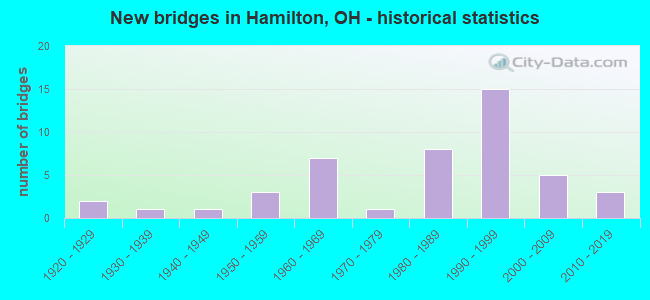
- New bridges - historical statistics
- 21920-1929
- 11930-1939
- 11940-1949
- 31950-1959
- 71960-1969
- 11970-1979
- 81980-1989
- 151990-1999
- 52000-2009
- 32010-2019
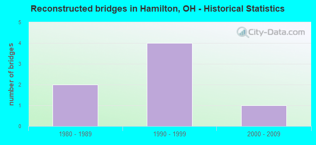
- Reconstructed bridges - Historical Statistics
- 21980-1989
- 41990-1999
- 12000-2009
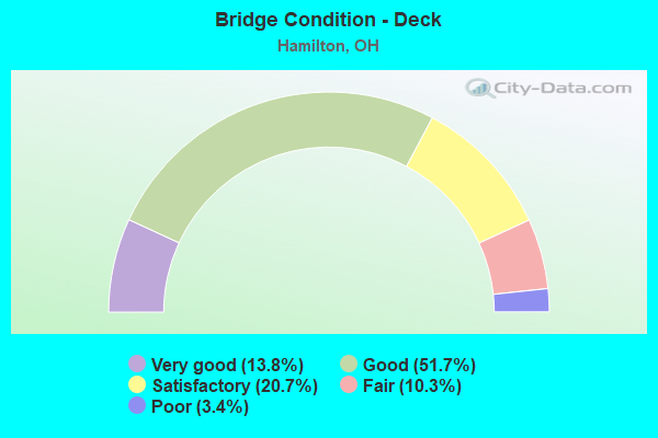
- Bridge Condition - Deck
- 13.8%Very good
- 51.7%Good
- 20.7%Satisfactory
- 10.3%Fair
- 3.4%Poor
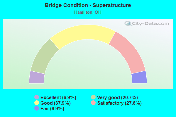
- Bridge Condition - Superstructure
- 6.9%Excellent
- 20.7%Very good
- 37.9%Good
- 27.6%Satisfactory
- 6.9%Fair
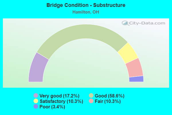
- Bridge Condition - Substructure
- 17.2%Very good
- 58.6%Good
- 10.3%Satisfactory
- 10.3%Fair
- 3.4%Poor
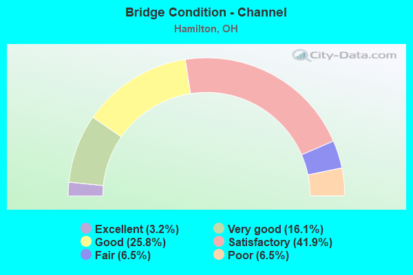
- Bridge Condition - Channel
- 3.2%Excellent
- 16.1%Very good
- 25.8%Good
- 41.9%Satisfactory
- 6.5%Fair
- 6.5%Poor
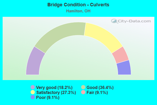
- Bridge Condition - Culverts
- 18.2%Very good
- 36.4%Good
- 27.3%Satisfactory
- 9.1%Fair
- 9.1%Poor
Find on map >> Show street view
Structure Number: 900052, Location: .22 MILES SOUTH OF SR-4 (Lat: 39.406269, Lng: -84.502461), Route carried "under" structure: Bypass State highway 4B, Year Built: 2000, Structure Length: 0. m, Average Daily Traffic: 14,436 (year 2016), Truck Traffic: 4%, Features Intersected: MILLIKIN RD CR-22, Facility Carried by Structure: MILLIKIN ROAD CR-2
Minimum Vertical Clearance: 7.62m (25.00ft), Kilometerpoint: 9.310, Lanes on structure: 2, Lanes under structure: 2, Material/Design: Prestressed concrete, Design/Construction: Box Beam or Girders - Multiple, Length of Maximum Span: 28.3m (92.8ft)
Find on map >> Show street view
Structure Number: 900567, Location: 4.35 N.OF SR-4 (Lat: 39.385711, Lng: -84.506211), Route carried "under" structure: State highway 129, Year Built: 1998, Structure Length: 0. m, Average Daily Traffic: 28,710 (year 2011), Truck Traffic: 5%, Features Intersected: BY-PASS SR-4B, Facility Carried by Structure: BYPASS 4
Minimum Vertical Clearance: 5.41m (17.75ft), Kilometerpoint: 28.695, Lanes on structure: 6, Lanes under structure: 4, Material/Design: Prestressed concrete continuous, Design/Construction: Stringer/Multi-beam, Length of Maximum Span: 33.3m (109.3ft)
Find on map >> Show street view
Structure Number: 90314, Location: .53 W OF SR 4 (Lat: 39.398550, Lng: -84.557461), Route carried "under" structure: State highway 129, Year Built: 1984, Structure Length: 0. m, Average Daily Traffic: 46,630 (year 2016), Truck Traffic: 7%, Features Intersected: WITT WAY MR-413, Facility Carried by Structure: WITT WAY MR-413
Minimum Vertical Clearance: 4.34m (14.24ft), Kilometerpoint: 23.796, Lanes on structure: 2, Lanes under structure: 4, Material/Design: Prestressed concrete, Design/Construction: Box Beam or Girders - Multiple, Length of Maximum Span: 21.0m (68.9ft)
Find on map >> Show street view
Structure Number: 903388, Location: 2.02 MI EAST OF SR 4 (Lat: 39.386589, Lng: -84.515461), Route carried "under" structure: County highway T-99, Year Built: 1999, Structure Length: 0. m, Average Daily Traffic: 1 (year 2000), Truck Traffic: 99%, Features Intersected: SR 129, Facility Carried by Structure: SR 129
Minimum Vertical Clearance: 4.42m (14.50ft), Lanes on structure: 4, Lanes under structure: 2, Material/Design: Prestressed concrete continuous, Design/Construction: Stringer/Multi-beam, Length of Maximum Span: 18.7m (61.4ft)
Find on map >> Show street view
Structure Number: 903477, Location: 3.03 MI. EAST OF SR 4 (Lat: 39.385339, Lng: -84.496769), Route carried "under" structure: County highway T-106, Year Built: 1999, Structure Length: 0. m, Average Daily Traffic: 1 (year 2000), Truck Traffic: 99%, Features Intersected: SR 129, Facility Carried by Structure: SR 129
Minimum Vertical Clearance: 4.60m (15.09ft), Lanes on structure: 2, Lanes under structure: 2, Material/Design: Prestressed concrete continuous, Design/Construction: Stringer/Multi-beam, Length of Maximum Span: 21.4m (70.2ft)
Find on map >> Show street view
Structure Number: 903485, Location: 3.03 MI. EAST OF SR 4 (Lat: 39.385131, Lng: -84.496789), Route carried "under" structure: County highway T-106, Year Built: 1999, Structure Length: 0. m, Average Daily Traffic: 5 (year 2003), Truck Traffic: 20%, Features Intersected: SR 129, Facility Carried by Structure: SR 129
Minimum Vertical Clearance: 4.60m (15.09ft), Lanes on structure: 2, Lanes under structure: 2, Material/Design: Prestressed concrete continuous, Design/Construction: Stringer/Multi-beam, Length of Maximum Span: 21.4m (70.2ft)