Bridge Statistics for Greenburgh, New York (NY)
Condition, Traffic, Stress, Structural Evaluation, Project Costs
- National Bridge Inventory (NBI) Statistics
- 78Number of bridges
- 814ft / 248mTotal length
- $338,105,000Total costs
- 1,210,566Total average daily traffic
- 55,428Total average daily truck traffic
- National Bridge Inventory (NBI) Registered Bridges for Greenburgh
- No street view available for this location
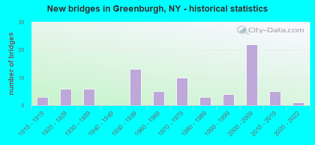
- New bridges - historical statistics
- 31910-1919
- 61920-1929
- 61930-1939
- 131950-1959
- 51960-1969
- 101970-1979
- 31980-1989
- 41990-1999
- 222000-2009
- 52010-2019
- 12020-2022
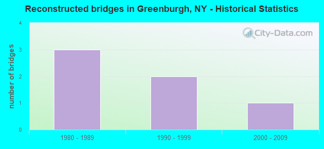
- Reconstructed bridges - Historical Statistics
- 31980-1989
- 21990-1999
- 12000-2009

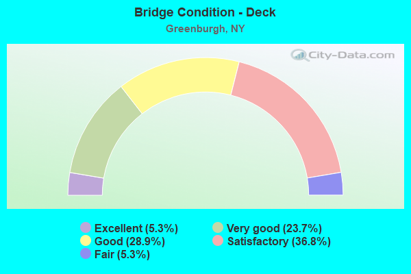
- Bridge Condition - Deck
- 5.3%Excellent
- 23.7%Very good
- 28.9%Good
- 36.8%Satisfactory
- 5.3%Fair
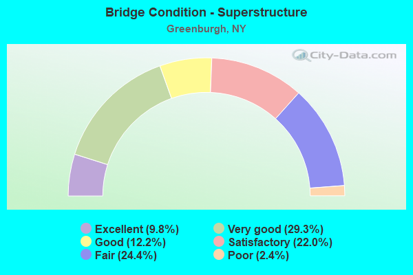
- Bridge Condition - Superstructure
- 9.8%Excellent
- 29.3%Very good
- 12.2%Good
- 22.0%Satisfactory
- 24.4%Fair
- 2.4%Poor
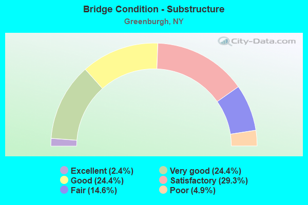
- Bridge Condition - Substructure
- 2.4%Excellent
- 24.4%Very good
- 24.4%Good
- 29.3%Satisfactory
- 14.6%Fair
- 4.9%Poor
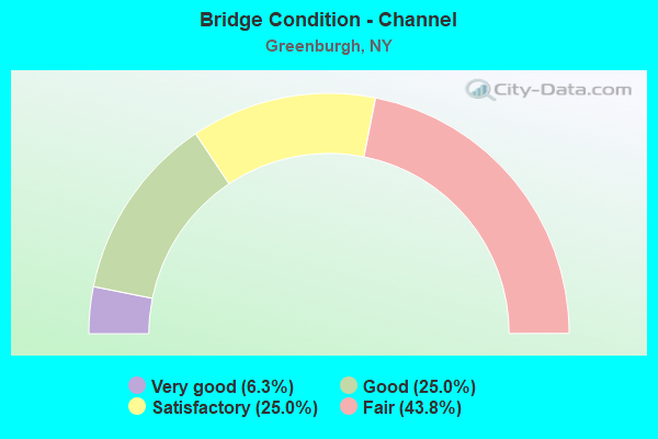
- Bridge Condition - Channel
- 6.3%Very good
- 25.0%Good
- 25.0%Satisfactory
- 43.8%Fair
Find on map >> Show street view
Structure Number: 100611, Location: jct rts 9A + 100C (Lat: 41.076283, Lng: -73.817783), Route carried "on" structure: US 100, Year Built: 2021, Status: Open, Structure Length: 2.90m (9.51ft), Average Daily Traffic: 10,302 (year 2017), Truck Traffic: 6%, Average Future Daily Traffic: 10,350 (year 2040), Design Load: HL 93, Features Intersected: 9A87032076
Minimum Vertical Clearance: 32.69m (107.25ft), Kilometerpoint: 0.434, Lanes on structure: 4, Lanes under structure: 4, Owner: State Highway Agency, Approaching Roadway Width: 20.4m (66.9ft), Material/Design: Steel, Design/Construction: Stringer/Multi-beam, Number Of Spans In Main Unit: 1, Length of Maximum Span: 27.4m (89.9ft), Curb or Sidewalk Widths: Left: 1.7m (5.6ft), Right: 1.7m (5.6ft), Curb-To-Curb Width: 17.1m (56.1ft), Out-to-Out Width: 20.9m (68.6ft)
Condition: Deck: Excellent, Superstructure: Excellent, Substructure: Very good, Operating Rating: 66.2 metric tons, Method Used To Determine Operating Rating: Load Factor (LF), Inventory Rating: 39.0 metric tons, Method Used To Determine Inventory Rating: Load Factor (LF), Structural Evaluation: Equal to present desirable criteria, Deck Geometry: Somewhat better than minimum adequacy, Underclear: Meets minimum limits, Approach Roadway Alignment: Meets minimum limits, Designated Inspection Frequency: Every 24 months, Inspection Date: December 2021, Deck Structure Type: Concrete Cast-file-Place, Wearing Surface/Protective System: Wearing Surface: Integral Concrete, Deck Protection: Epoxy Coated Reinforcing
Find on map >> Show street view
Structure Number: 103608, Location: .2 MI E JCT SH100 & SH119 (Lat: 41.040456, Lng: -73.787364), Route carried "on" structure: Ramp Interstate , Year Built: 2001, Status: Open, Structure Length: 5.88m (19.29ft), Average Daily Traffic: 10,478 (year 2016), Truck Traffic: 3%, Average Future Daily Traffic: 17,743 (year 2040), Design Load: HS 25 or greater, Features Intersected: 100 100 87014005 EB, R, Facility Carried by Structure: EB287toEB100+119
Minimum Vertical Clearance: 30+ m (98+ ft), Kilometerpoint: 0.611, Lanes on structure: 2, Lanes under structure: 6, Owner: State Highway Agency, Approaching Roadway Width: 11.6m (38.1ft), Skew: 3 degrees, Material/Design: Prestressed concrete continuous, Design/Construction: Stringer/Multi-beam, Number Of Spans In Main Unit: 2, Length of Maximum Span: 28.5m (93.5ft), Curb-To-Curb Width: 11.7m (38.4ft), Out-to-Out Width: 12.8m (42.0ft)
Condition: Deck: Good, Superstructure: Very good, Substructure: Very good, Operating Rating: 76.1 metric tons, Method Used To Determine Operating Rating: Load and Resistance Factor Rating (LRFR) rating reported by rating factor(RF) method using HL-93 loadings, Inventory Rating: 53.8 metric tons, Method Used To Determine Inventory Rating: Load and Resistance Factor Rating (LRFR) rating reported by rating factor(RF) method using HL-93 loadings, Structural Evaluation: Equal to present desirable criteria, Deck Geometry: Superior to present desirable criteria, Underclear: Meets minimum limits, Approach Roadway Alignment: Equal to present desirable criteria, Length Of Structure Improvement: 5.88m (19.29ft), Designated Inspection Frequency: Every 24 months, Inspection Date: April 2021, Bridge Improvement Cost: $2,377,000, Roadway Improvement Cost: $1,392,000, Total Project Cost: $3,768,000 ( Estimate for 2021), Deck Structure Type: Concrete Cast-file-Place, Wearing Surface/Protective System: Wearing Surface: Monolithic Concrete, Deck Protection: Epoxy Coated Reinforcing
Find on map >> Show street view
Structure Number: 103609, Location: EXIT 5-I287 TO SH 100 (Lat: 41.040800, Lng: -73.786711), Route carried "on" structure: Ramp State highway , Year Built: 1960, Status: Open, Structure Length: 1.04m (3.41ft), Average Daily Traffic: 14,612 (year 2016), Truck Traffic: 4%, Average Future Daily Traffic: 24,743 (year 2040), Design Load: HS 20, Features Intersected: MANHATTEN BROOK, Facility Carried by Structure: RAMP TO I287
Minimum Vertical Clearance: 30+ m (98+ ft), Kilometerpoint: 0.080, Lanes on structure: 1, Owner: State Highway Agency, Approaching Roadway Width: 10.4m (34.1ft), Skew: 6 degrees, Material/Design: Concrete continuous, Design/Construction: Culvert, Number Of Spans In Main Unit: 2, Length of Maximum Span: 4.8m (15.7ft)
Condition: Channel: Fair, Culverts: Satisfactory, Structural Evaluation: Equal to present minimum criteria, Waterway Adequacy: Equal to present desirable criteria, Approach Roadway Alignment: Equal to present desirable criteria, Length Of Structure Improvement: 1.03m (3.38ft), Designated Inspection Frequency: Every 24 months, Inspection Date: March 2020, Bridge Improvement Cost: $302,000, Roadway Improvement Cost: $177,000, Total Project Cost: $479,000 ( Estimate for 2021)
Find on map >> Show street view
Structure Number: 10362, Location: JCT RTS 100A+119 (Lat: 41.045536, Lng: -73.804783), Route carried "on" structure: State highway 100A, Year Built: 1932, Status: Open, Structure Length: 1.80m (5.91ft), Average Daily Traffic: 17,585 (year 2011), Truck Traffic: 6%, Average Future Daily Traffic: 21,362 (year 2040), Features Intersected: RTE 119
Minimum Vertical Clearance: 30+ m (98+ ft), Kilometerpoint: 3.524, Lanes on structure: 4, Lanes under structure: 4, Base Highway Network: Yes, Owner: State Highway Agency, Approaching Roadway Width: 15.2m (49.9ft), Skew: 2 degrees, Material/Design: Concrete, Design/Construction: Frame, Number Of Spans In Main Unit: 1, Length of Maximum Span: 16.1m (52.8ft), Curb or Sidewalk Widths: Left: 1.6m (5.2ft), Right: 1.6m (5.2ft), Curb-To-Curb Width: 12.2m (40.0ft), Out-to-Out Width: 16.3m (53.5ft)
Condition: Superstructure: Satisfactory, Substructure: Good, Operating Rating: 55.4 metric tons, Method Used To Determine Operating Rating: Field evaluation and documented engineering judgment, Inventory Rating: 20.5 metric tons, Method Used To Determine Inventory Rating: Field evaluation and documented engineering judgment, Structural Evaluation: Somewhat better than minimum adequacy, Deck Geometry: High priority of replacement, Underclear: High priority of corrective action, Approach Roadway Alignment: Meets minimum limits, Length Of Structure Improvement: 1.79m (5.87ft), Designated Inspection Frequency: Every 24 months, Inspection Date: April 2020, Bridge Improvement Cost: $1,685,000, Roadway Improvement Cost: $987,000, Total Project Cost: $2,672,000 ( Estimate for 2021), Deck Structure Type: Concrete Cast-file-Place, Wearing Surface/Protective System: Wearing Surface: Bituminous
Find on map >> Show street view
Structure Number: 103622, Location: 0.1 MI W JCT RTS 100B+119 (Lat: 41.041272, Lng: -73.795081), Route carried "on" structure: State highway 100B, Year Built: 1932, Status: Open, Structure Length: 0.82m (2.69ft), Average Daily Traffic: 8,499 (year 2019), Truck Traffic: 3%, Average Future Daily Traffic: 10,324 (year 2040), Design Load: HS 20, Features Intersected: MANHATTAN BROOK
Minimum Vertical Clearance: 30+ m (98+ ft), Kilometerpoint: 4.457, Lanes on structure: 2, Base Highway Network: Yes, Owner: State Highway Agency, Approaching Roadway Width: 10.7m (35.1ft), Material/Design: Concrete, Design/Construction: Slab, Number Of Spans In Main Unit: 1, Length of Maximum Span: 7.3m (24.0ft), Curb or Sidewalk Widths: Left: 1.5m (4.9ft), Right: 1.5m (4.9ft), Curb-To-Curb Width: 10.7m (35.1ft), Out-to-Out Width: 14.1m (46.3ft)
Condition: Deck: Fair, Superstructure: Fair, Substructure: Fair, Channel: Fair, Operating Rating: 97.2 metric tons, Method Used To Determine Operating Rating: Load and Resistance Factor Rating (LRFR) rating reported by rating factor(RF) method using HL-93 loadings, Inventory Rating: 97.2 metric tons, Method Used To Determine Inventory Rating: Load and Resistance Factor Rating (LRFR) rating reported by rating factor(RF) method using HL-93 loadings, Structural Evaluation: Somewhat better than minimum adequacy, Deck Geometry: Meets minimum limits, Waterway Adequacy: Equal to present desirable criteria, Approach Roadway Alignment: Meets minimum limits, Length Of Structure Improvement: 0.82m (2.69ft), Designated Inspection Frequency: Every 24 months, Inspection Date: March 2020, Bridge Improvement Cost: $547,000, Roadway Improvement Cost: $320,000, Total Project Cost: $867,000 ( Estimate for 2021), Wearing Surface/Protective System: Wearing Surface: Bituminous
Find on map >> Show street view
Structure Number: 10446, Location: JCT I287 & SH 100A (Lat: 41.047114, Lng: -73.803983), Route carried "on" structure: State highway 100A, Year Built: 2004, Status: Open, Structure Length: 5.82m (19.09ft), Average Daily Traffic: 17,585 (year 2020), Truck Traffic: 10%, Average Future Daily Traffic: 21,362 (year 2040), Design Load: HS 25 or greater, Features Intersected: 287I287I87011018 WB, RTE
Minimum Vertical Clearance: 30+ m (98+ ft), Kilometerpoint: 3.701, Lanes on structure: 4, Lanes under structure: 7, Base Highway Network: Yes, Owner: State Highway Agency, Approaching Roadway Width: 21.3m (69.9ft), Material/Design: Steel continuous, Design/Construction: Stringer/Multi-beam, Number Of Spans In Main Unit: 2, Length of Maximum Span: 28.7m (94.2ft), Curb or Sidewalk Widths: Left: 1.5m (4.9ft), Right: 1.5m (4.9ft), Curb-To-Curb Width: 21.3m (69.9ft), Out-to-Out Width: 24.9m (81.7ft)
Condition: Deck: Very good, Superstructure: Very good, Substructure: Very good, Operating Rating: 68.9 metric tons, Method Used To Determine Operating Rating: Load Factor (LF), Inventory Rating: 49.0 metric tons, Method Used To Determine Inventory Rating: Load Factor (LF), Structural Evaluation: Equal to present desirable criteria, Deck Geometry: Superior to present desirable criteria, Underclear: High priority of corrective action, Approach Roadway Alignment: Equal to present desirable criteria, Length Of Structure Improvement: 5.82m (19.09ft), Designated Inspection Frequency: Every 24 months, Inspection Date: October 2021, Bridge Improvement Cost: $7,265,000, Roadway Improvement Cost: $4,255,000, Total Project Cost: $11,520,000 ( Estimate for 2021), Deck Structure Type: Concrete Cast-file-Place, Wearing Surface/Protective System: Wearing Surface: Integral Concrete, Deck Protection: Galvanized Reinforcing
Find on map >> Show street view
Structure Number: 1044629, Location: 1.4 MI E JCT I287 & SH 9A (Lat: 41.045881, Lng: -73.797031), Route carried "on" structure: Interstate 287, Year Built: 2004, Status: Open, Structure Length: 2.56m (8.40ft), Truck Traffic: 15%, Design Load: HS 25 or greater, Features Intersected: MANHATTAN AVENUE
Minimum Vertical Clearance: 30+ m (98+ ft), Kilometerpoint: 9.413, Lanes on structure: 7, Lanes under structure: 2, Base Highway Network: Yes, Owner: State Highway Agency, Approaching Roadway Width: 35.1m (115.2ft), Skew: 20 degrees, Material/Design: Prestressed concrete, Design/Construction: Stringer/Multi-beam, Number Of Spans In Main Unit: 1, Length of Maximum Span: 24.5m (80.4ft), Curb-To-Curb Width: 35.0m (114.8ft), Out-to-Out Width: 40.2m (131.9ft)
Condition: Deck: Satisfactory, Superstructure: Very good, Substructure: Good, Operating Rating: 93.4 metric tons, Method Used To Determine Operating Rating: Load Factor (LF), Inventory Rating: 53.5 metric tons, Method Used To Determine Inventory Rating: Load Factor (LF), Structural Evaluation: Better than present minimum criteria, Deck Geometry: Superior to present desirable criteria, Underclear: Somewhat better than minimum adequacy, Approach Roadway Alignment: Equal to present desirable criteria, Length Of Structure Improvement: 2.56m (8.40ft), Designated Inspection Frequency: Every 24 months, Inspection Date: December 2020, Bridge Improvement Cost: $6,646,000, Roadway Improvement Cost: $3,892,000, Total Project Cost: $10,538,000 ( Estimate for 2021), Deck Structure Type: Concrete Cast-file-Place, Wearing Surface/Protective System: Wearing Surface: Monolithic Concrete, Deck Protection: Galvanized Reinforcing
Find on map >> Show street view
Structure Number: 104463, Location: JCT RTDS I287 & RT 100 (Lat: 41.044800, Lng: -73.790458), Route carried "on" structure: State highway 100, Year Built: 2001, Status: Open, Structure Length: 8.35m (27.40ft), Average Daily Traffic: 12,660 (year 2019), Truck Traffic: 6%, Average Future Daily Traffic: 15,379 (year 2040), Design Load: HS 25 or greater, Features Intersected: 287I287I87011025 WB, RT
Minimum Vertical Clearance: 30+ m (98+ ft), Kilometerpoint: 15.173, Lanes on structure: 4, Lanes under structure: 7, Base Highway Network: Yes, Owner: State Highway Agency, Approaching Roadway Width: 14.9m (48.9ft), Skew: 2 degrees, Material/Design: Steel continuous, Design/Construction: Stringer/Multi-beam, Number Of Spans In Main Unit: 3, Length of Maximum Span: 28.5m (93.5ft), Curb or Sidewalk Widths: Left: 1.5m (4.9ft), Right: 1.5m (4.9ft), Curb-To-Curb Width: 15.0m (49.2ft), Out-to-Out Width: 18.6m (61.0ft)
Condition: Deck: Good, Superstructure: Very good, Substructure: Good, Inventory Rating: 62.6 metric tons, Method Used To Determine Inventory Rating: Load Factor (LF), Structural Evaluation: Better than present minimum criteria, Deck Geometry: High priority of replacement, Underclear: High priority of corrective action, Approach Roadway Alignment: Equal to present desirable criteria, Length Of Structure Improvement: 8.35m (27.40ft), Designated Inspection Frequency: Every 24 months, Inspection Date: November 2021, Bridge Improvement Cost: $6,299,000, Roadway Improvement Cost: $3,689,000, Total Project Cost: $9,988,000 ( Estimate for 2021), Deck Structure Type: Concrete Cast-file-Place, Wearing Surface/Protective System: Wearing Surface: Integral Concrete, Deck Protection: Epoxy Coated Reinforcing
Find on map >> Show street view
Structure Number: 104464, Location: .1 MI E JCT I287 & SH 100 (Lat: 41.043367, Lng: -73.788239), Route carried "on" structure: Ramp Interstate , Year Built: 2001, Status: Open, Structure Length: 8.02m (26.31ft), Average Daily Traffic: 9,756 (year 2016), Truck Traffic: 3%, Average Future Daily Traffic: 16,520 (year 2040), Design Load: HS 25 or greater, Features Intersected: 287I287I87011027 WB, RTE, Facility Carried by Structure: RAMP P TO I287
Minimum Vertical Clearance: 30+ m (98+ ft), Kilometerpoint: 0.274, Lanes on structure: 1, Lanes under structure: 6, Owner: State Highway Agency, Approaching Roadway Width: 7.9m (25.9ft), Skew: 4 degrees, Material/Design: Steel continuous, Design/Construction: Stringer/Multi-beam, Number Of Spans In Main Unit: 2, Length of Maximum Span: 39.0m (128.0ft), Curb-To-Curb Width: 7.8m (25.6ft), Out-to-Out Width: 8.7m (28.5ft)
Condition: Deck: Good, Superstructure: Very good, Substructure: Very good, Operating Rating: 94.3 metric tons, Method Used To Determine Operating Rating: Load Factor (LF), Inventory Rating: 56.2 metric tons, Method Used To Determine Inventory Rating: Load Factor (LF), Structural Evaluation: Equal to present desirable criteria, Deck Geometry: Better than present minimum criteria, Underclear: High priority of corrective action, Approach Roadway Alignment: Equal to present desirable criteria, Length Of Structure Improvement: 8.01m (26.28ft), Designated Inspection Frequency: Every 24 months, Inspection Date: November 2021, Bridge Improvement Cost: $3,376,000, Roadway Improvement Cost: $1,977,000, Total Project Cost: $5,353,000 ( Estimate for 2021), Deck Structure Type: Concrete Cast-file-Place, Wearing Surface/Protective System: Wearing Surface: Integral Concrete, Deck Protection: Epoxy Coated Reinforcing
Find on map >> Show street view
Structure Number: 1044659, Location: JCT RTE I287 & BRP (Lat: 41.044008, Lng: -73.775983), Route carried "on" structure: Interstate 287, Year Built: 1999, Status: Open, Structure Length: 39.29m (128.90ft), Average Daily Traffic: 105,783 (year 2019), Truck Traffic: 12%, Average Future Daily Traffic: 179,132 (year 2040), Design Load: HS 25 or greater, Features Intersected: Old Kensico Rd, Ferris A
Minimum Vertical Clearance: 30+ m (98+ ft), Kilometerpoint: 11.150, Lanes on structure: 7, Lanes under structure: 8, Base Highway Network: Yes, Owner: State Highway Agency, Approaching Roadway Width: 40.5m (132.9ft), Skew: 23 degrees, Material/Design: Steel continuous, Design/Construction: Box Beam or Girders - Multiple, Number Of Spans In Main Unit: 9, Length of Maximum Span: 47.2m (154.9ft), Curb-To-Curb Width: 40.5m (132.9ft), Out-to-Out Width: 42.2m (138.5ft)
Condition: Deck: Very good, Superstructure: Good, Substructure: Good, Channel: Good, Operating Rating: 96.5 metric tons, Method Used To Determine Operating Rating: Field evaluation and documented engineering judgment, Inventory Rating: 40.8 metric tons, Method Used To Determine Inventory Rating: Field evaluation and documented engineering judgment, Structural Evaluation: Better than present minimum criteria, Deck Geometry: Superior to present desirable criteria, Underclear: High priority of corrective action, Waterway Adequacy: Equal to present minimum criteria, Approach Roadway Alignment: Equal to present desirable criteria, Length Of Structure Improvement: 39.28m (128.87ft), Designated Inspection Frequency: Every 24 months, Inspection Date: November 2021, Bridge Improvement Cost: $38,133,000, Roadway Improvement Cost: $22,331,000, Total Project Cost: $60,464,000 ( Estimate for 2021), Deck Structure Type: Concrete Precast Panels, Wearing Surface/Protective System: Wearing Surface: Integral Concrete
Find on map >> Show street view
Structure Number: 1070481, Location: 0.6MI N INT 287I & SBSP (Lat: 41.062353, Lng: -73.807297), Route carried "on" structure: Other road 987F, Year Built: 2017, Status: Open, Structure Length: 2.80m (9.19ft), Average Daily Traffic: 43,572 (year 2014), Truck Traffic: 1%, Average Future Daily Traffic: 61,467 (year 2040), Design Load: HS 20, Features Intersected: PAYNE ST
Minimum Vertical Clearance: 30+ m (98+ ft), Kilometerpoint: 15.511, Lanes on structure: 3, Lanes under structure: 2, Base Highway Network: Yes, Owner: State Highway Agency, Approaching Roadway Width: 15.8m (51.8ft), Skew: 2 degrees, Material/Design: Steel, Design/Construction: Stringer/Multi-beam, Number Of Spans In Main Unit: 1, Length of Maximum Span: 27.4m (89.9ft), Curb-To-Curb Width: 15.8m (51.8ft), Out-to-Out Width: 17.1m (56.1ft)
Condition: Deck: Very good, Superstructure: Very good, Substructure: Very good, Operating Rating: 74.4 metric tons, Method Used To Determine Operating Rating: Load Factor (LF), Inventory Rating: 44.5 metric tons, Method Used To Determine Inventory Rating: Load Factor (LF), Structural Evaluation: Equal to present desirable criteria, Deck Geometry: Somewhat better than minimum adequacy, Underclear: Somewhat better than minimum adequacy, Approach Roadway Alignment: Equal to present desirable criteria, Length Of Structure Improvement: 2.80m (9.19ft), Designated Inspection Frequency: Every 24 months, Inspection Date: April 2020, Bridge Improvement Cost: $3,762,000, Roadway Improvement Cost: $2,203,000, Total Project Cost: $5,964,000 ( Estimate for 2021), Deck Structure Type: Concrete Cast-file-Place, Wearing Surface/Protective System: Wearing Surface: Integral Concrete, Deck Protection: Epoxy Coated Reinforcing
Find on map >> Show street view
Structure Number: 1070482, Location: 0.6MI N INT 287I & SBSP (Lat: 41.062375, Lng: -73.807078), Route carried "on" structure: Other road 987F, Year Built: 1981, Status: Open, Structure Length: 2.01m (6.59ft), Average Daily Traffic: 43,572 (year 2014), Truck Traffic: 1%, Average Future Daily Traffic: 61,467 (year 2040), Design Load: HS 20, Features Intersected: PAYNE ST
Minimum Vertical Clearance: 30+ m (98+ ft), Kilometerpoint: 15.511, Lanes on structure: 3, Lanes under structure: 2, Base Highway Network: Yes, Owner: State Highway Agency, Approaching Roadway Width: 15.8m (51.8ft), Skew: 2 degrees, Material/Design: Prestressed concrete, Design/Construction: Box Beam or Girders - Multiple, Number Of Spans In Main Unit: 1, Length of Maximum Span: 19.5m (64.0ft), Curb-To-Curb Width: 15.7m (51.5ft), Out-to-Out Width: 16.9m (55.4ft)
Condition: Deck: Satisfactory, Superstructure: Satisfactory, Substructure: Satisfactory, Operating Rating: 88.9 metric tons, Method Used To Determine Operating Rating: Load Factor (LF), Inventory Rating: 52.6 metric tons, Method Used To Determine Inventory Rating: Load Factor (LF), Structural Evaluation: Equal to present minimum criteria, Deck Geometry: Somewhat better than minimum adequacy, Underclear: Equal to present minimum criteria, Approach Roadway Alignment: Equal to present desirable criteria, Length Of Structure Improvement: 2.01m (6.59ft), Designated Inspection Frequency: Every 24 months, Inspection Date: April 2020, Bridge Improvement Cost: $922,000, Roadway Improvement Cost: $540,000, Total Project Cost: $1,462,000 ( Estimate for 2021), Wearing Surface/Protective System: Wearing Surface: Monolithic Concrete
Find on map >> Show street view
Structure Number: 107791, Location: I87 NB RAMP X TO I287 EB (Lat: 41.056667, Lng: -73.834422), Route carried "on" structure: Ramp Interstate , Year Built: 2003, Status: Open, Structure Length: 3.23m (10.60ft), Average Daily Traffic: 7,448 (year 2020), Truck Traffic: 26%, Average Future Daily Traffic: 12,612 (year 2040), Design Load: HS 25 or greater, Features Intersected: RAMP W I87 TO 119, Facility Carried by Structure: RAMP X I87 N TO I2
Minimum Vertical Clearance: 30+ m (98+ ft), Kilometerpoint: 0.274, Lanes on structure: 2, Lanes under structure: 1, Toll: On Interstate toll segment, Owner: State Toll Authority, Approaching Roadway Width: 11.9m (39.0ft), Skew: 4 degrees, Material/Design: Steel, Design/Construction: Stringer/Multi-beam, Number Of Spans In Main Unit: 1, Length of Maximum Span: 29.9m (98.1ft), Curb-To-Curb Width: 11.8m (38.7ft), Out-to-Out Width: 12.7m (41.7ft)
Condition: Deck: Excellent, Superstructure: Excellent, Substructure: Very good, Operating Rating: 76.2 metric tons, Method Used To Determine Operating Rating: Load Factor (LF), Inventory Rating: 45.4 metric tons, Method Used To Determine Inventory Rating: Load Factor (LF), Structural Evaluation: Equal to present desirable criteria, Deck Geometry: Superior to present desirable criteria, Underclear: Somewhat better than minimum adequacy, Approach Roadway Alignment: Equal to present minimum criteria, Length Of Structure Improvement: 3.23m (10.60ft), Designated Inspection Frequency: Every 24 months, Inspection Date: November 2021, Bridge Improvement Cost: $2,846,000, Roadway Improvement Cost: $1,666,000, Total Project Cost: $4,512,000 ( Estimate for 2021), Deck Structure Type: Concrete Cast-file-Place, Wearing Surface/Protective System: Wearing Surface: Integral Concrete, Deck Protection: Galvanized Reinforcing
Find on map >> Show street view
Structure Number: 107792, Location: JCT OF I-87 & I-287 (Lat: 41.057700, Lng: -73.834367), Route carried "on" structure: Ramp Other road , Year Built: 2003, Status: Open, Structure Length: 9.75m (31.99ft), Average Daily Traffic: 11,412 (year 2020), Truck Traffic: 21%, Average Future Daily Traffic: 19,325 (year 2040), Design Load: HS 25 or greater, Features Intersected: 287IX EB, 287IX, Facility Carried by Structure: 87IXINT 8 RAMP V
Minimum Vertical Clearance: 30+ m (98+ ft), Kilometerpoint: 0.370, Lanes on structure: 2, Lanes under structure: 6, Toll: On Interstate toll segment, Owner: State Toll Authority, Approaching Roadway Width: 10.7m (35.1ft), Skew: 5 degrees, Material/Design: Steel, Design/Construction: Box Beam or Girders - Multiple, Number Of Spans In Main Unit: 2, Length of Maximum Span: 50.0m (164.0ft), Curb-To-Curb Width: 10.5m (34.4ft), Out-to-Out Width: 11.4m (37.4ft)
Condition: Deck: Very good, Superstructure: Very good, Substructure: Very good, Inventory Rating: 50.3 metric tons, Method Used To Determine Inventory Rating: Allowable Stress (AS), Structural Evaluation: Equal to present desirable criteria, Deck Geometry: Better than present minimum criteria, Underclear: High priority of corrective action, Approach Roadway Alignment: Equal to present minimum criteria, Length Of Structure Improvement: 9.75m (31.99ft), Designated Inspection Frequency: Every 24 months, Critical Feature Inspection Frequency: Every 24 months, Inspection Date: November 2021, Critical Feature Inspection Date: November 2021, Bridge Improvement Cost: $4,783,000, Roadway Improvement Cost: $2,801,000, Total Project Cost: $7,585,000 ( Estimate for 2021), Deck Structure Type: Concrete Cast-file-Place, Wearing Surface/Protective System: Wearing Surface: Integral Concrete, Deck Protection: Galvanized Reinforcing
Find on map >> Show street view
Structure Number: 109136, Location: 1 MI E JCT SH119 & SH100A (Lat: 41.040586, Lng: -73.787286), Route carried "on" structure: State highway 100, Year Built: 1958, Status: Open, Structure Length: 0.73m (2.40ft), Average Daily Traffic: 42,903 (year 2017), Truck Traffic: 3%, Average Future Daily Traffic: 43,104 (year 2040), Design Load: HS 20, Features Intersected: 287 RAMP, MANHATTEN PARK
Minimum Vertical Clearance: 4.52m (14.83ft), Kilometerpoint: 14.481, Lanes on structure: 6, Base Highway Network: Yes, Owner: State Highway Agency, Approaching Roadway Width: 24.4m (80.1ft), Skew: 34 degrees, Material/Design: Concrete, Design/Construction: Culvert, Number Of Spans In Main Unit: 2, Length of Maximum Span: 3.3m (10.8ft), Curb or Sidewalk Widths: Left: 1.8m (5.9ft), Right: 0.0m
Condition: Channel: Fair, Culverts: Satisfactory, Inventory Rating: 81.6 metric tons, Method Used To Determine Inventory Rating: Load Factor (LF), Structural Evaluation: Equal to present minimum criteria, Waterway Adequacy: Superior to present desirable criteria, Approach Roadway Alignment: Equal to present desirable criteria, Length Of Structure Improvement: 0.73m (2.40ft), Designated Inspection Frequency: Every 24 months, Inspection Date: September 2020, Bridge Improvement Cost: $985,000, Roadway Improvement Cost: $577,000, Total Project Cost: $1,561,000 ( Estimate for 2021)
Find on map >> Show street view
Structure Number: 109148, Location: JCT RTE 100B+SBP (Lat: 41.035672, Lng: -73.816719), Route carried "on" structure: State highway 100B, Year Built: 1970, Status: Open, Structure Length: 4.94m (16.21ft), Average Daily Traffic: 14,681 (year 2020), Truck Traffic: 4%, Average Future Daily Traffic: 17,834 (year 2040), Design Load: HS 20, Features Intersected: 987F987F87012038 SB, RTE
Minimum Vertical Clearance: 30+ m (98+ ft), Kilometerpoint: 2.462, Lanes on structure: 4, Lanes under structure: 6, Base Highway Network: Yes, Owner: State Highway Agency, Approaching Roadway Width: 14.6m (47.9ft), Skew: 3 degrees, Material/Design: Steel, Design/Construction: Stringer/Multi-beam, Number Of Spans In Main Unit: 2, Length of Maximum Span: 23.7m (77.8ft), Curb-To-Curb Width: 16.1m (52.8ft), Out-to-Out Width: 17.2m (56.4ft)
Condition: Deck: Satisfactory, Superstructure: Fair, Substructure: Satisfactory, Operating Rating: 70.3 metric tons, Method Used To Determine Operating Rating: Load and Resistance Factor Rating (LRFR) rating reported by rating factor(RF) method using HL-93 loadings, Inventory Rating: 54.4 metric tons, Method Used To Determine Inventory Rating: Load and Resistance Factor Rating (LRFR) rating reported by rating factor(RF) method using HL-93 loadings, Structural Evaluation: Somewhat better than minimum adequacy, Deck Geometry: Meets minimum limits, Underclear: Meets minimum limits, Approach Roadway Alignment: Equal to present desirable criteria, Length Of Structure Improvement: 4.93m (16.17ft), Designated Inspection Frequency: Every 24 months, Inspection Date: August 2020, Bridge Improvement Cost: $4,773,000, Roadway Improvement Cost: $2,795,000, Total Project Cost: $7,569,000 ( Estimate for 2021), Deck Structure Type: Concrete Cast-file-Place, Wearing Surface/Protective System: Wearing Surface: Bituminous
Find on map >> Show street view
Structure Number: 226521, Location: 2.1 MILES EAST OF ARDSLEY (Lat: 41.010347, Lng: -73.796308), Route carried "on" structure: Other road , Year Built: 1912, Year Reconstructed: 1987, Status: Open, Structure Length: 3.84m (12.60ft), Average Daily Traffic: 12,768 (year 2010), Truck Traffic: 4%, Average Future Daily Traffic: 15,510 (year 2040), Design Load: HS 20, Features Intersected: PIPE LINE ROAD, MNRR HA, Facility Carried by Structure: FENIMORE ROAD
Minimum Vertical Clearance: 30+ m (98+ ft), Kilometerpoint: 0.016, Lanes on structure: 2, Lanes under structure: 2, Owner: Railroad, Maintenance Responsibility: Town or Township Highway Agency, Approaching Roadway Width: 9.1m (29.9ft), Material/Design: Prestressed concrete continuous, Design/Construction: Box Beam or Girders - Multiple, Number Of Spans In Main Unit: 2, Length of Maximum Span: 20.1m (65.9ft), Curb or Sidewalk Widths: Left: 0.0m, Right: 2.4m (7.9ft), Curb-To-Curb Width: 9.1m (29.9ft), Out-to-Out Width: 12.3m (40.4ft)
Condition: Deck: Good, Superstructure: Excellent, Substructure: Good, Operating Rating: 29.2 metric tons, Method Used To Determine Operating Rating: Load and Resistance Factor Rating (LRFR) rating reported by rating factor(RF) method using HL-93 loadings, Inventory Rating: 21.1 metric tons, Method Used To Determine Inventory Rating: Load and Resistance Factor Rating (LRFR) rating reported by rating factor(RF) method using HL-93 loadings, Structural Evaluation: Somewhat better than minimum adequacy, Deck Geometry: High priority of corrective action, Underclear: High priority of corrective action, Approach Roadway Alignment: Meets minimum limits, Length Of Structure Improvement: 3.84m (12.60ft), Designated Inspection Frequency: Every 24 months, Inspection Date: August 2021, Bridge Improvement Cost: $1,407,000, Roadway Improvement Cost: $824,000, Total Project Cost: $2,232,000 ( Estimate for 2021), Wearing Surface/Protective System: Wearing Surface: Monolithic Concrete
Find on map >> Show street view
Structure Number: 226524, Location: 1.0MI S OF ARDSLEY (Lat: 41.001786, Lng: -73.854469), Route carried "on" structure: Other road , Year Built: 1984, Status: Open, Structure Length: 1.25m (4.10ft), Average Daily Traffic: 4,174 (year 2020), Truck Traffic: 2%, Average Future Daily Traffic: 5,844 (year 2040), Design Load: HS 20, Features Intersected: SAW MILL RIVER, Facility Carried by Structure: LAWRENCE STREET
Minimum Vertical Clearance: 30+ m (98+ ft), Kilometerpoint: 0.129, Lanes on structure: 2, Owner: Town or Township Highway Agency, Approaching Roadway Width: 7.3m (24.0ft), Material/Design: Prestressed concrete, Design/Construction: Box Beam or Girders - Multiple, Number Of Spans In Main Unit: 1, Length of Maximum Span: 10.9m (35.8ft), Curb or Sidewalk Widths: Left: 1.8m (5.9ft), Right: 1.8m (5.9ft), Curb-To-Curb Width: 7.3m (24.0ft), Out-to-Out Width: 11.3m (37.1ft)
Condition: Deck: Satisfactory, Superstructure: Good, Substructure: Good, Channel: Satisfactory, Operating Rating: 53.1 metric tons, Method Used To Determine Operating Rating: Load and Resistance Factor Rating (LRFR) rating reported by rating factor(RF) method using HL-93 loadings, Inventory Rating: 41.1 metric tons, Method Used To Determine Inventory Rating: Load and Resistance Factor Rating (LRFR) rating reported by rating factor(RF) method using HL-93 loadings, Structural Evaluation: Better than present minimum criteria, Deck Geometry: High priority of replacement, Waterway Adequacy: Somewhat better than minimum adequacy, Approach Roadway Alignment: Equal to present desirable criteria, Length Of Structure Improvement: 1.24m (4.07ft), Designated Inspection Frequency: Every 24 months, Inspection Date: June 2021, Bridge Improvement Cost: $618,000, Roadway Improvement Cost: $362,000, Total Project Cost: $980,000 ( Estimate for 2021), Deck Structure Type: Concrete Cast-file-Place, Wearing Surface/Protective System: Wearing Surface: Integral Concrete, Deck Protection: Epoxy Coated Reinforcing
Find on map >> Show street view
Structure Number: 226584, Location: 2.2 MI E OF ARDSLEY (Lat: 41.009617, Lng: -73.796656), Route carried "on" structure: Ramp Other road , Year Built: 1912, Status: Posted for load, Structure Length: 1.19m (3.90ft), Average Daily Traffic: 2,369 (year 1996), Truck Traffic: 3%, Average Future Daily Traffic: 3,317 (year 2016), Features Intersected: BRONX RIVER, Facility Carried by Structure: ACCESS RD PKG LOT
Minimum Vertical Clearance: 30+ m (98+ ft), Kilometerpoint: 0.000, Lanes on structure: 2, Owner: Town or Township Highway Agency, Approaching Roadway Width: 6.1m (20.0ft), Skew: 2 degrees, Material/Design: Steel, Design/Construction: Stringer/Multi-beam, Number Of Spans In Main Unit: 1, Length of Maximum Span: 11.2m (36.7ft), Curb-To-Curb Width: 6.1m (20.0ft), Out-to-Out Width: 6.1m (20.0ft)
Condition: Deck: Satisfactory, Superstructure: Poor, Substructure: Satisfactory, Channel: Fair, Operating Rating: 16.2 metric tons, Method Used To Determine Operating Rating: Load and Resistance Factor Rating (LRFR) rating reported by rating factor(RF) method using HL-93 loadings, Inventory Rating: 12.6 metric tons, Method Used To Determine Inventory Rating: Load and Resistance Factor Rating (LRFR) rating reported by rating factor(RF) method using HL-93 loadings, Structural Evaluation: Meets minimum limits, Deck Geometry: High priority of replacement, Waterway Adequacy: Equal to present desirable criteria, Approach Roadway Alignment: Meets minimum limits, Bridge Posting: Required (Relationship of Operating Rating to Maximum Legal Load: > 39.9% below), Length Of Structure Improvement: 1.18m (3.87ft), Designated Inspection Frequency: Every 12 months, Inspection Date: April 2021, Bridge Improvement Cost: $629,000, Roadway Improvement Cost: $368,000, Total Project Cost: $997,000 ( Estimate for 2021), Deck Structure Type: Concrete Cast-file-Place, Wearing Surface/Protective System: Wearing Surface: Bituminous
Find on map >> Show street view
Structure Number: 226957, Location: IN ELMSFORD (Lat: 41.066481, Lng: -73.818083), Route carried "on" structure: Other road , Year Built: 1970, Status: Open, Structure Length: 2.93m (9.61ft), Average Daily Traffic: 2,721 (year 2016), Truck Traffic: 21%, Average Future Daily Traffic: 3,809 (year 2036), Design Load: HS 20, Features Intersected: SAW MILL RIVER, Facility Carried by Structure: FAIRVIEW PK DRIVE
Minimum Vertical Clearance: 32.69m (107.25ft), Kilometerpoint: 0.853, Lanes on structure: 2, Owner: Town or Township Highway Agency, Approaching Roadway Width: 14.0m (45.9ft), Skew: 5 degrees, Material/Design: Prestressed concrete, Design/Construction: Box Beam or Girders - Multiple, Number Of Spans In Main Unit: 3, Length of Maximum Span: 12.2m (40.0ft), Curb or Sidewalk Widths: Left: 1.5m (4.9ft), Right: 0.6m (2.0ft), Curb-To-Curb Width: 12.5m (41.0ft), Out-to-Out Width: 14.6m (47.9ft)
Condition: Deck: Fair, Superstructure: Fair, Substructure: Poor, Channel: Fair, Operating Rating: 76.5 metric tons, Method Used To Determine Operating Rating: Field evaluation and documented engineering judgment, Inventory Rating: 29.4 metric tons, Method Used To Determine Inventory Rating: Field evaluation and documented engineering judgment, Structural Evaluation: Meets minimum limits, Deck Geometry: Equal to present minimum criteria, Waterway Adequacy: Equal to present desirable criteria, Approach Roadway Alignment: Equal to present minimum criteria, Length Of Structure Improvement: 2.92m (9.58ft), Designated Inspection Frequency: Every 24 months, Inspection Date: May 2021, Bridge Improvement Cost: $5,815,000, Roadway Improvement Cost: $3,405,000, Total Project Cost: $9,220,000 ( Estimate for 2021), Wearing Surface/Protective System: Wearing Surface: Bituminous
Find on map >> Show street view
Structure Number: 22706, Location: 1 MI N JCT 287I & 907G (Lat: 41.053522, Lng: -73.772678), Route carried "on" structure: Other road , Year Built: 1999, Year Reconstructed: 2011, Status: Open, Structure Length: 0.88m (2.89ft), Average Daily Traffic: 4,531 (year 2017), Truck Traffic: 1%, Average Future Daily Traffic: 5,606 (year 2040), Features Intersected: Bronx River, Facility Carried by Structure: Fisher Lane
Minimum Vertical Clearance: 30+ m (98+ ft), Kilometerpoint: 0.322, Lanes on structure: 2, Owner: Town or Township Highway Agency, Approaching Roadway Width: 6.1m (20.0ft), Material/Design: Steel, Design/Construction: Stringer/Multi-beam, Number Of Spans In Main Unit: 1, Length of Maximum Span: 8.2m (26.9ft), Curb or Sidewalk Widths: Left: 0.0m, Right: 1.2m (3.9ft), Curb-To-Curb Width: 6.1m (20.0ft), Out-to-Out Width: 7.6m (24.9ft)
Condition: Deck: Good, Superstructure: Very good, Substructure: Fair, Channel: Fair, Operating Rating: 68.4 metric tons, Method Used To Determine Operating Rating: Load and Resistance Factor Rating (LRFR) rating reported by rating factor(RF) method using HL-93 loadings, Inventory Rating: 52.8 metric tons, Method Used To Determine Inventory Rating: Load and Resistance Factor Rating (LRFR) rating reported by rating factor(RF) method using HL-93 loadings, Structural Evaluation: Somewhat better than minimum adequacy, Deck Geometry: High priority of replacement, Waterway Adequacy: Meets minimum limits, Approach Roadway Alignment: Equal to present desirable criteria, Length Of Structure Improvement: 0.88m (2.89ft), Designated Inspection Frequency: Every 24 months, Inspection Date: June 2021, Bridge Improvement Cost: $231,000, Roadway Improvement Cost: $135,000, Total Project Cost: $367,000 ( Estimate for 2021), Deck Structure Type: Open Grating, Wearing Surface/Protective System: Wearing Surface: Other
Find on map >> Show street view
Structure Number: 334862, Location: 0.5 MI N JCT RTS BRP<287 (Lat: 41.051053, Lng: -73.774925), Route carried "on" structure: Other road 907G, Year Built: 1923, Year Reconstructed: 1987, Status: Open, Structure Length: 0.85m (2.79ft), Average Daily Traffic: 15,983 (year 2010), Truck Traffic: 2%, Average Future Daily Traffic: 22,547 (year 2040), Features Intersected: BRONX RIVER
Minimum Vertical Clearance: 30+ m (98+ ft), Kilometerpoint: 19.260, Lanes on structure: 4, Owner: County Highway Agency, Approaching Roadway Width: 14.6m (47.9ft), Skew: 20 degrees, Material/Design: Prestressed concrete, Design/Construction: Box Beam or Girders - Multiple, Number Of Spans In Main Unit: 1, Length of Maximum Span: 7.3m (24.0ft), Curb-To-Curb Width: 17.7m (58.1ft), Out-to-Out Width: 20.0m (65.6ft)
Condition: Deck: Good, Superstructure: Good, Substructure: Satisfactory, Channel: Good, Operating Rating: 52.8 metric tons, Method Used To Determine Operating Rating: Field evaluation and documented engineering judgment, Inventory Rating: 24.5 metric tons, Method Used To Determine Inventory Rating: Field evaluation and documented engineering judgment, Structural Evaluation: Equal to present minimum criteria, Deck Geometry: Meets minimum limits, Waterway Adequacy: High priority of replacement, Approach Roadway Alignment: Meets minimum limits, Length Of Structure Improvement: 0.85m (2.79ft), Designated Inspection Frequency: Every 24 months, Inspection Date: June 2021, Bridge Improvement Cost: $1,420,000, Roadway Improvement Cost: $832,000, Total Project Cost: $2,252,000 ( Estimate for 2021), Wearing Surface/Protective System: Wearing Surface: Bituminous
Find on map >> Show street view
Structure Number: 334863, Location: 0.3 MI N JCT RTS BRP+287 (Lat: 41.048322, Lng: -73.775050), Route carried "on" structure: Other road , Year Built: 1923, Status: Open, Structure Length: 0.79m (2.59ft), Average Daily Traffic: 14,142 (year 2010), Truck Traffic: 2%, Average Future Daily Traffic: 19,950 (year 2040), Features Intersected: BRONX RIVER, Facility Carried by Structure: 907GX
Minimum Vertical Clearance: 30+ m (98+ ft), Kilometerpoint: 18.954, Lanes on structure: 4, Owner: County Highway Agency, Approaching Roadway Width: 14.6m (47.9ft), Skew: 20 degrees, Material/Design: Prestressed concrete, Design/Construction: Box Beam or Girders - Multiple, Number Of Spans In Main Unit: 1, Length of Maximum Span: 7.6m (24.9ft), Curb or Sidewalk Widths: Left: 0.2m (0.7ft), Right: 0.2m (0.7ft), Curb-To-Curb Width: 18.5m (60.7ft), Out-to-Out Width: 20.0m (65.6ft)
Condition: Deck: Good, Superstructure: Good, Substructure: Satisfactory, Channel: Satisfactory, Operating Rating: 51.2 metric tons, Method Used To Determine Operating Rating: Field evaluation and documented engineering judgment, Inventory Rating: 23.6 metric tons, Method Used To Determine Inventory Rating: Field evaluation and documented engineering judgment, Structural Evaluation: Somewhat better than minimum adequacy, Deck Geometry: Meets minimum limits, Waterway Adequacy: Meets minimum limits, Approach Roadway Alignment: Meets minimum limits, Length Of Structure Improvement: 0.79m (2.59ft), Designated Inspection Frequency: Every 24 months, Inspection Date: May 2021, Bridge Improvement Cost: $1,184,000, Roadway Improvement Cost: $693,000, Total Project Cost: $1,877,000 ( Estimate for 2021), Wearing Surface/Protective System: Wearing Surface: Bituminous
Find on map >> Show street view
Structure Number: 334867, Location: 0.3 MI S JCT RTS BRP+287 (Lat: 41.039419, Lng: -73.777267), Route carried "on" structure: Other road , Year Built: 1923, Status: Open, Structure Length: 1.01m (3.31ft), Average Daily Traffic: 12,015 (year 2020), Truck Traffic: 1%, Average Future Daily Traffic: 16,949 (year 2040), Features Intersected: BRONX RIVER, Facility Carried by Structure: 907GX
Minimum Vertical Clearance: 30+ m (98+ ft), Kilometerpoint: 17.924, Lanes on structure: 2, Owner: County Highway Agency, Approaching Roadway Width: 6.4m (21.0ft), Material/Design: Concrete, Design/Construction: Arch - Deck, Number Of Spans In Main Unit: 1, Length of Maximum Span: 9.4m (30.8ft), Curb-To-Curb Width: 6.4m (21.0ft), Out-to-Out Width: 7.5m (24.6ft)
Condition: Deck: Satisfactory, Superstructure: Satisfactory, Substructure: Satisfactory, Channel: Fair, Operating Rating: 50.8 metric tons, Method Used To Determine Operating Rating: Allowable Stress (AS), Inventory Rating: 36.3 metric tons, Method Used To Determine Inventory Rating: Allowable Stress (AS), Structural Evaluation: Equal to present minimum criteria, Deck Geometry: High priority of replacement, Waterway Adequacy: Meets minimum limits, Approach Roadway Alignment: Equal to present desirable criteria, Length Of Structure Improvement: 1.00m (3.28ft), Designated Inspection Frequency: Every 24 months, Inspection Date: May 2021, Bridge Improvement Cost: $354,000, Roadway Improvement Cost: $208,000, Total Project Cost: $562,000 ( Estimate for 2021)
Find on map >> Show street view
Structure Number: 334873, Location: 2.3 MILES EAST OF ARDSLEY (Lat: 41.011217, Lng: -73.795050), Route carried "on" structure: Other road , Year Built: 1925, Year Reconstructed: 1988, Status: Open, Structure Length: 1.31m (4.30ft), Average Daily Traffic: 1,451 (year 1996), Truck Traffic: 10%, Average Future Daily Traffic: 2,031 (year 2016), Design Load: HS 20+Mod, Features Intersected: BRONX RIVER, Facility Carried by Structure: GREENACRES AVENUE
Minimum Vertical Clearance: 30+ m (98+ ft), Kilometerpoint: 0.000, Lanes on structure: 2, Owner: County Highway Agency, Approaching Roadway Width: 7.9m (25.9ft), Skew: 2 degrees, Material/Design: Prestressed concrete, Design/Construction: Box Beam or Girders - Multiple, Number Of Spans In Main Unit: 1, Length of Maximum Span: 11.2m (36.7ft), Curb or Sidewalk Widths: Left: 2.4m (7.9ft), Right: 0.0m, Curb-To-Curb Width: 7.2m (23.6ft), Out-to-Out Width: 10.9m (35.8ft)
Condition: Deck: Satisfactory, Superstructure: Satisfactory, Substructure: Satisfactory, Channel: Satisfactory, Operating Rating: 65.8 metric tons, Method Used To Determine Operating Rating: Load and Resistance Factor Rating (LRFR) rating reported by rating factor(RF) method using HL-93 loadings, Inventory Rating: 47.6 metric tons, Method Used To Determine Inventory Rating: Load and Resistance Factor Rating (LRFR) rating reported by rating factor(RF) method using HL-93 loadings, Structural Evaluation: Equal to present minimum criteria, Deck Geometry: High priority of replacement, Waterway Adequacy: Meets minimum limits, Approach Roadway Alignment: Equal to present minimum criteria, Length Of Structure Improvement: 1.31m (4.30ft), Designated Inspection Frequency: Every 24 months, Inspection Date: May 2021, Bridge Improvement Cost: $818,000, Roadway Improvement Cost: $479,000, Total Project Cost: $1,298,000 ( Estimate for 2021), Wearing Surface/Protective System: Wearing Surface: Bituminous
Find on map >> Show street view
Structure Number: 3348779, Location: 4.0 MI N JCT RTS BRP&SBSP (Lat: 40.991489, Lng: -73.808606), Route carried "on" structure: Other road 907G, Year Built: 2015, Status: Open, Structure Length: 11.40m (37.40ft), Average Daily Traffic: 23,973 (year 2020), Average Future Daily Traffic: 33,818 (year 2040), Design Load: HL 93, Features Intersected: BRONX RIVER
Minimum Vertical Clearance: 30+ m (98+ ft), Kilometerpoint: 11.520, Lanes on structure: 4, Base Highway Network: Yes, Owner: County Highway Agency, Approaching Roadway Width: 17.7m (58.1ft), Skew: 20 degrees, Material/Design: Steel, Number Of Spans In Main Unit: 7, Length of Maximum Span: 18.9m (62.0ft), Curb-To-Curb Width: 17.4m (57.1ft), Out-to-Out Width: 19.3m (63.3ft)
Condition: Deck: Very good, Superstructure: Very good, Substructure: Very good, Channel: Good, Operating Rating: 66.2 metric tons, Method Used To Determine Operating Rating: Load Factor (LF), Inventory Rating: 39.0 metric tons, Method Used To Determine Inventory Rating: Load Factor (LF), Structural Evaluation: Equal to present desirable criteria, Deck Geometry: Meets minimum limits, Waterway Adequacy: Equal to present minimum criteria, Approach Roadway Alignment: Equal to present desirable criteria, Length Of Structure Improvement: 11.39m (37.37ft), Designated Inspection Frequency: Every 24 months, Inspection Date: December 2021, Bridge Improvement Cost: $8,868,000, Roadway Improvement Cost: $5,193,000, Total Project Cost: $14,060,000 ( Estimate for 2021), Deck Structure Type: Concrete Cast-file-Place, Wearing Surface/Protective System: Wearing Surface: Bituminous, Membrane: Other, Deck Protection: Galvanized Reinforcing
Find on map >> Show street view
Structure Number: 334879, Location: 3.9 MI N JCT BRP & SBSP (Lat: 40.988947, Lng: -73.810489), Route carried "on" structure: County highway , Year Built: 1925, Status: Open, Structure Length: 1.49m (4.89ft), Average Daily Traffic: 9,212 (year 2010), Truck Traffic: 6%, Average Future Daily Traffic: 9,255 (year 2040), Features Intersected: 907 BRP SB, 907G BRP, Facility Carried by Structure: ARDSLEY ROAD
Minimum Vertical Clearance: 30+ m (98+ ft), Kilometerpoint: 0.000, Lanes on structure: 3, Lanes under structure: 4, Owner: County Highway Agency, Approaching Roadway Width: 9.1m (29.9ft), Skew: 1 degrees, Material/Design: Concrete, Design/Construction: Frame, Number Of Spans In Main Unit: 1, Length of Maximum Span: 13.1m (43.0ft), Curb or Sidewalk Widths: Left: 0.0m, Right: 1.8m (5.9ft), Curb-To-Curb Width: 10.7m (35.1ft), Out-to-Out Width: 14.0m (45.9ft)
Condition: Superstructure: Satisfactory, Substructure: Satisfactory, Operating Rating: 49.0 metric tons, Method Used To Determine Operating Rating: Allowable Stress (AS), Inventory Rating: 15.4 metric tons, Method Used To Determine Inventory Rating: Allowable Stress (AS), Structural Evaluation: High priority of corrective action, Deck Geometry: High priority of replacement, Underclear: High priority of corrective action, Approach Roadway Alignment: Better than present minimum criteria, Length Of Structure Improvement: 1.49m (4.89ft), Designated Inspection Frequency: Every 24 months, Inspection Date: May 2021, Bridge Improvement Cost: $1,125,000, Roadway Improvement Cost: $659,000, Total Project Cost: $1,784,000 ( Estimate for 2021)
Find on map >> Show street view
Structure Number: 5500719, Location: 0.1 MI N JCT RTS SMRP(Lat: 41.044047, Lng: -73.835003), Route carried "on" structure: Other road 987D, Year Built: 2019, Status: Open, Structure Length: 5.85m (19.19ft), Truck Traffic: 2%, Design Load: HL 93, Features Intersected: SAW MILL RIVER
Minimum Vertical Clearance: 30+ m (98+ ft), Kilometerpoint: 16.010, Lanes on structure: 4, Base Highway Network: Yes, Owner: State Highway Agency, Approaching Roadway Width: 19.8m (65.0ft), Skew: 26 degrees, Material/Design: Steel continuous, Design/Construction: Stringer/Multi-beam, Number Of Spans In Main Unit: 3, Length of Maximum Span: 22.9m (75.1ft), Curb-To-Curb Width: 19.9m (65.3ft), Out-to-Out Width: 21.4m (70.2ft)
Condition: Deck: Very good, Superstructure: Very good, Substructure: Very good, Channel: Satisfactory, Inventory Rating: 86.2 metric tons, Method Used To Determine Inventory Rating: Load Factor (LF), Structural Evaluation: Equal to present desirable criteria, Deck Geometry: Equal to present minimum criteria, Waterway Adequacy: Meets minimum limits, Approach Roadway Alignment: Equal to present minimum criteria, Length Of Structure Improvement: 5.85m (19.19ft), Designated Inspection Frequency: Every 24 months, Inspection Date: May 2020, Bridge Improvement Cost: $5,552,000, Roadway Improvement Cost: $3,251,000, Total Project Cost: $8,803,000 ( Estimate for 2021), Deck Structure Type: Concrete Cast-file-Place, Wearing Surface/Protective System: Wearing Surface: Integral Concrete, Deck Protection: Galvanized Reinforcing
Structure Number: 5500719, Location: 0.1 MI N JCT RTS SMRP
Minimum Vertical Clearance: 30+ m (98+ ft), Kilometerpoint: 16.010, Lanes on structure: 4, Base Highway Network: Yes, Owner: State Highway Agency, Approaching Roadway Width: 19.8m (65.0ft), Skew: 26 degrees, Material/Design: Steel continuous, Design/Construction: Stringer/Multi-beam, Number Of Spans In Main Unit: 3, Length of Maximum Span: 22.9m (75.1ft), Curb-To-Curb Width: 19.9m (65.3ft), Out-to-Out Width: 21.4m (70.2ft)
Condition: Deck: Very good, Superstructure: Very good, Substructure: Very good, Channel: Satisfactory, Inventory Rating: 86.2 metric tons, Method Used To Determine Inventory Rating: Load Factor (LF), Structural Evaluation: Equal to present desirable criteria, Deck Geometry: Equal to present minimum criteria, Waterway Adequacy: Meets minimum limits, Approach Roadway Alignment: Equal to present minimum criteria, Length Of Structure Improvement: 5.85m (19.19ft), Designated Inspection Frequency: Every 24 months, Inspection Date: May 2020, Bridge Improvement Cost: $5,552,000, Roadway Improvement Cost: $3,251,000, Total Project Cost: $8,803,000 ( Estimate for 2021), Deck Structure Type: Concrete Cast-file-Place, Wearing Surface/Protective System: Wearing Surface: Integral Concrete, Deck Protection: Galvanized Reinforcing
Find on map >> Show street view
Structure Number: 5500739, Location: .3 MI N JCT SMRP & I87 (Lat: 41.046128, Lng: -73.831956), Route carried "on" structure: State highway 987D, Year Built: 2019, Status: Open, Structure Length: 4.63m (15.19ft), Truck Traffic: 2%, Design Load: HL 93, Features Intersected: SAW MILL RIVER
Minimum Vertical Clearance: 30+ m (98+ ft), Kilometerpoint: 16.364, Lanes on structure: 5, Base Highway Network: Yes, Owner: State Highway Agency, Approaching Roadway Width: 23.2m (76.1ft), Skew: 30 degrees, Material/Design: Steel, Design/Construction: Stringer/Multi-beam, Number Of Spans In Main Unit: 3, Length of Maximum Span: 18.3m (60.0ft), Curb-To-Curb Width: 23.2m (76.1ft), Out-to-Out Width: 25.1m (82.3ft)
Condition: Deck: Very good, Superstructure: Excellent, Substructure: Excellent, Channel: Good, Operating Rating: 97.2 metric tons, Method Used To Determine Operating Rating: Load and Resistance Factor Rating (LRFR) rating reported by rating factor(RF) method using HL-93 loadings, Inventory Rating: 75.2 metric tons, Method Used To Determine Inventory Rating: Load and Resistance Factor Rating (LRFR) rating reported by rating factor(RF) method using HL-93 loadings, Structural Evaluation: Superior to present desirable criteria, Deck Geometry: Somewhat better than minimum adequacy, Waterway Adequacy: Meets minimum limits, Approach Roadway Alignment: Equal to present desirable criteria, Length Of Structure Improvement: 4.63m (15.19ft), Designated Inspection Frequency: Every 24 months, Inspection Date: July 2021, Bridge Improvement Cost: $4,404,000, Roadway Improvement Cost: $2,579,000, Total Project Cost: $6,982,000 ( Estimate for 2021), Deck Structure Type: Concrete Cast-file-Place, Wearing Surface/Protective System: Wearing Surface: Integral Concrete, Deck Protection: Epoxy Coated Reinforcing
Find on map >> Show street view
Structure Number: 5500759, Location: 2.6 MI S JCT RTS SMRP(Lat: 41.081433, Lng: -73.829253), Route carried "on" structure: State highway 987D, Year Built: 1933, Status: Open, Structure Length: 1.65m (5.41ft), Average Daily Traffic: 40,435 (year 2020), Truck Traffic: 1%, Average Future Daily Traffic: 57,041 (year 2040), Design Load: HS 20, Features Intersected: OLD SAWMILLRIV.RD
Minimum Vertical Clearance: 30+ m (98+ ft), Kilometerpoint: 21.271, Lanes on structure: 5, Lanes under structure: 4, Base Highway Network: Yes, Owner: State Highway Agency, Approaching Roadway Width: 23.8m (78.1ft), Skew: 21 degrees, Material/Design: Concrete, Design/Construction: Frame, Number Of Spans In Main Unit: 1, Length of Maximum Span: 15.8m (51.8ft), Curb or Sidewalk Widths: Left: 1.2m (3.9ft), Right: 0.0m, Curb-To-Curb Width: 21.5m (70.5ft), Out-to-Out Width: 24.7m (81.0ft)
Condition: Superstructure: Fair, Substructure: Fair, Operating Rating: 82.7 metric tons, Method Used To Determine Operating Rating: Field evaluation and documented engineering judgment, Inventory Rating: 29.4 metric tons, Method Used To Determine Inventory Rating: Field evaluation and documented engineering judgment, Structural Evaluation: Somewhat better than minimum adequacy, Deck Geometry: Meets minimum limits, Underclear: Meets minimum limits, Approach Roadway Alignment: Equal to present desirable criteria, Length Of Structure Improvement: 1.64m (5.38ft), Designated Inspection Frequency: Every 24 months, Inspection Date: September 2020, Bridge Improvement Cost: $2,269,000, Roadway Improvement Cost: $1,328,000, Total Project Cost: $3,597,000 ( Estimate for 2021)
Structure Number: 5500759, Location: 2.6 MI S JCT RTS SMRP
Minimum Vertical Clearance: 30+ m (98+ ft), Kilometerpoint: 21.271, Lanes on structure: 5, Lanes under structure: 4, Base Highway Network: Yes, Owner: State Highway Agency, Approaching Roadway Width: 23.8m (78.1ft), Skew: 21 degrees, Material/Design: Concrete, Design/Construction: Frame, Number Of Spans In Main Unit: 1, Length of Maximum Span: 15.8m (51.8ft), Curb or Sidewalk Widths: Left: 1.2m (3.9ft), Right: 0.0m, Curb-To-Curb Width: 21.5m (70.5ft), Out-to-Out Width: 24.7m (81.0ft)
Condition: Superstructure: Fair, Substructure: Fair, Operating Rating: 82.7 metric tons, Method Used To Determine Operating Rating: Field evaluation and documented engineering judgment, Inventory Rating: 29.4 metric tons, Method Used To Determine Inventory Rating: Field evaluation and documented engineering judgment, Structural Evaluation: Somewhat better than minimum adequacy, Deck Geometry: Meets minimum limits, Underclear: Meets minimum limits, Approach Roadway Alignment: Equal to present desirable criteria, Length Of Structure Improvement: 1.64m (5.38ft), Designated Inspection Frequency: Every 24 months, Inspection Date: September 2020, Bridge Improvement Cost: $2,269,000, Roadway Improvement Cost: $1,328,000, Total Project Cost: $3,597,000 ( Estimate for 2021)
Find on map >> Show street view
Structure Number: 550165, Location: N END GRASSY SPRAIN RES (Lat: 40.988236, Lng: -73.838925), Route carried "on" structure: Other road , Year Built: 1966, Status: Open, Structure Length: 2.10m (6.89ft), Average Daily Traffic: 14,077 (year 2018), Truck Traffic: 4%, Average Future Daily Traffic: 17,100 (year 2040), Design Load: HS 20, Features Intersected: RTE 987F, Facility Carried by Structure: JACKSON AVENUE
Minimum Vertical Clearance: 30+ m (98+ ft), Kilometerpoint: 2.269, Lanes on structure: 4, Lanes under structure: 4, Owner: State Highway Agency, Approaching Roadway Width: 14.6m (47.9ft), Skew: 2 degrees, Material/Design: Steel, Design/Construction: Stringer/Multi-beam, Number Of Spans In Main Unit: 1, Length of Maximum Span: 19.5m (64.0ft), Curb or Sidewalk Widths: Left: 1.1m (3.6ft), Right: 1.1m (3.6ft), Curb-To-Curb Width: 14.6m (47.9ft), Out-to-Out Width: 17.3m (56.8ft)
Condition: Deck: Satisfactory, Superstructure: Satisfactory, Substructure: Fair, Operating Rating: 71.9 metric tons, Method Used To Determine Operating Rating: Load and Resistance Factor Rating (LRFR) rating reported by rating factor(RF) method using HL-93 loadings, Inventory Rating: 55.4 metric tons, Method Used To Determine Inventory Rating: Load and Resistance Factor Rating (LRFR) rating reported by rating factor(RF) method using HL-93 loadings, Structural Evaluation: Somewhat better than minimum adequacy, Deck Geometry: High priority of replacement, Underclear: High priority of corrective action, Approach Roadway Alignment: Equal to present desirable criteria, Length Of Structure Improvement: 2.10m (6.89ft), Designated Inspection Frequency: Every 24 months, Inspection Date: October 2020, Bridge Improvement Cost: $2,984,000, Roadway Improvement Cost: $1,748,000, Total Project Cost: $4,732,000 ( Estimate for 2021), Deck Structure Type: Concrete Cast-file-Place, Wearing Surface/Protective System: Wearing Surface: Bituminous
Find on map >> Show street view
Structure Number: 550166, Location: N END GRASSY SPRAIN RES (Lat: 40.988625, Lng: -73.840533), Route carried "on" structure: Other road , Year Built: 1965, Status: Open, Structure Length: 1.74m (5.71ft), Average Daily Traffic: 14,077 (year 2018), Truck Traffic: 4%, Average Future Daily Traffic: 17,100 (year 2040), Features Intersected: RTE 987F, Facility Carried by Structure: JACKSON AVENUE
Minimum Vertical Clearance: 30+ m (98+ ft), Kilometerpoint: 2.124, Lanes on structure: 4, Lanes under structure: 3, Owner: State Highway Agency, Approaching Roadway Width: 14.6m (47.9ft), Skew: 1 degrees, Material/Design: Steel, Design/Construction: Stringer/Multi-beam, Number Of Spans In Main Unit: 1, Length of Maximum Span: 16.4m (53.8ft), Curb or Sidewalk Widths: Left: 1.1m (3.6ft), Right: 1.1m (3.6ft), Curb-To-Curb Width: 14.6m (47.9ft), Out-to-Out Width: 17.4m (57.1ft)
Condition: Deck: Satisfactory, Superstructure: Satisfactory, Substructure: Fair, Operating Rating: 66.7 metric tons, Method Used To Determine Operating Rating: Load and Resistance Factor Rating (LRFR) rating reported by rating factor(RF) method using HL-93 loadings, Inventory Rating: 51.2 metric tons, Method Used To Determine Inventory Rating: Load and Resistance Factor Rating (LRFR) rating reported by rating factor(RF) method using HL-93 loadings, Structural Evaluation: Somewhat better than minimum adequacy, Deck Geometry: High priority of replacement, Underclear: High priority of corrective action, Approach Roadway Alignment: Equal to present desirable criteria, Length Of Structure Improvement: 1.73m (5.68ft), Designated Inspection Frequency: Every 24 months, Inspection Date: July 2020, Bridge Improvement Cost: $2,481,000, Roadway Improvement Cost: $1,453,000, Total Project Cost: $3,933,000 ( Estimate for 2021), Deck Structure Type: Concrete Cast-file-Place, Wearing Surface/Protective System: Wearing Surface: Bituminous
Find on map >> Show street view
Structure Number: 550167, Location: 1.0 MI SE OF ARDSLEY (Lat: 40.999706, Lng: -73.831681), Route carried "on" structure: Other road , Year Built: 1970, Status: Open, Structure Length: 5.73m (18.80ft), Average Daily Traffic: 7,349 (year 2018), Truck Traffic: 3%, Average Future Daily Traffic: 7,383 (year 2040), Design Load: HS 20, Features Intersected: 987FX SB, RTE 987F, Facility Carried by Structure: ARDSLEY ROAD
Minimum Vertical Clearance: 30+ m (98+ ft), Kilometerpoint: 0.547, Lanes on structure: 2, Lanes under structure: 6, Owner: State Highway Agency, Approaching Roadway Width: 16.3m (53.5ft), Skew: 3 degrees, Material/Design: Steel, Design/Construction: Stringer/Multi-beam, Number Of Spans In Main Unit: 2, Length of Maximum Span: 27.7m (90.9ft), Curb-To-Curb Width: 16.3m (53.5ft), Out-to-Out Width: 17.2m (56.4ft)
Condition: Deck: Good, Superstructure: Satisfactory, Substructure: Poor, Operating Rating: 64.5 metric tons, Method Used To Determine Operating Rating: Load and Resistance Factor Rating (LRFR) rating reported by rating factor(RF) method using HL-93 loadings, Inventory Rating: 49.9 metric tons, Method Used To Determine Inventory Rating: Load and Resistance Factor Rating (LRFR) rating reported by rating factor(RF) method using HL-93 loadings, Structural Evaluation: Meets minimum limits, Deck Geometry: Superior to present desirable criteria, Underclear: High priority of corrective action, Approach Roadway Alignment: Equal to present desirable criteria, Length Of Structure Improvement: 5.73m (18.80ft), Designated Inspection Frequency: Every 24 months, Inspection Date: September 2021, Bridge Improvement Cost: $5,372,000, Roadway Improvement Cost: $3,146,000, Total Project Cost: $8,518,000 ( Estimate for 2021), Deck Structure Type: Concrete Cast-file-Place, Wearing Surface/Protective System: Wearing Surface: Bituminous
Find on map >> Show street view
Structure Number: 550168, Location: 3.4 MI S JCT RTS SBSP+287 (Lat: 41.008369, Lng: -73.829508), Route carried "on" structure: Other road , Year Built: 1970, Status: Open, Structure Length: 4.79m (15.72ft), Average Daily Traffic: 2,478 (year 2018), Truck Traffic: 3%, Average Future Daily Traffic: 3,066 (year 2040), Design Load: HS 20, Features Intersected: 987F 987F87012001 SB, RT, Facility Carried by Structure: UNDERHILL ROAD
Minimum Vertical Clearance: 30+ m (98+ ft), Kilometerpoint: 0.161, Lanes on structure: 2, Lanes under structure: 6, Owner: State Highway Agency, Approaching Roadway Width: 8.5m (27.9ft), Skew: 1 degrees, Material/Design: Steel, Design/Construction: Stringer/Multi-beam, Number Of Spans In Main Unit: 2, Length of Maximum Span: 23.5m (77.1ft), Curb-To-Curb Width: 9.5m (31.2ft), Out-to-Out Width: 11.2m (36.7ft)
Condition: Deck: Good, Superstructure: Satisfactory, Substructure: Satisfactory, Operating Rating: 69.7 metric tons, Method Used To Determine Operating Rating: Load and Resistance Factor Rating (LRFR) rating reported by rating factor(RF) method using HL-93 loadings, Inventory Rating: 53.8 metric tons, Method Used To Determine Inventory Rating: Load and Resistance Factor Rating (LRFR) rating reported by rating factor(RF) method using HL-93 loadings, Structural Evaluation: Equal to present minimum criteria, Deck Geometry: Meets minimum limits, Underclear: High priority of corrective action, Approach Roadway Alignment: Equal to present desirable criteria, Length Of Structure Improvement: 4.78m (15.68ft), Designated Inspection Frequency: Every 24 months, Inspection Date: June 2021, Bridge Improvement Cost: $2,782,000, Roadway Improvement Cost: $1,629,000, Total Project Cost: $4,412,000 ( Estimate for 2021), Deck Structure Type: Concrete Cast-file-Place, Wearing Surface/Protective System: Wearing Surface: Bituminous, Membrane: Other
Find on map >> Show street view
Structure Number: 550169, Location: 2.7 MI S JCT RTS SBSP+287 (Lat: 41.017375, Lng: -73.825139), Route carried "on" structure: Other road , Year Built: 1970, Status: Open, Structure Length: 11.64m (38.19ft), Truck Traffic: 4%, Design Load: HS 20, Features Intersected: 987FX NB, RTE 987F, CATS, Facility Carried by Structure: HEATHERDELL ROAD
Minimum Vertical Clearance: 30+ m (98+ ft), Kilometerpoint: 0.000, Lanes on structure: 2, Owner: State Highway Agency, Approaching Roadway Width: 9.1m (29.9ft), Skew: 2 degrees, Material/Design: Steel, Design/Construction: Stringer/Multi-beam, Number Of Spans In Main Unit: 5, Length of Maximum Span: 23.7m (77.8ft), Curb-To-Curb Width: 10.4m (34.1ft), Out-to-Out Width: 11.2m (36.7ft)
Condition: Deck: Satisfactory, Superstructure: Fair, Substructure: Good, Operating Rating: 90.7 metric tons, Method Used To Determine Operating Rating: Load Factor (LF), Inventory Rating: 54.4 metric tons, Method Used To Determine Inventory Rating: Load Factor (LF), Structural Evaluation: Somewhat better than minimum adequacy, Deck Geometry: Superior to present desirable criteria, Approach Roadway Alignment: Equal to present desirable criteria, Length Of Structure Improvement: 11.64m (38.19ft), Designated Inspection Frequency: Every 24 months, Inspection Date: December 2021, Bridge Improvement Cost: $5,311,000, Roadway Improvement Cost: $3,110,000, Total Project Cost: $8,422,000 ( Estimate for 2021), Deck Structure Type: Concrete Cast-file-Place, Wearing Surface/Protective System: Wearing Surface: Bituminous
Find on map >> Show street view
Structure Number: 55017, Location: 2.0 MI S JCT RTS SBSP+287 (Lat: 41.027606, Lng: -73.821067), Route carried "on" structure: Other road , Year Built: 1970, Status: Open, Structure Length: 9.17m (30.09ft), Average Daily Traffic: 3,105 (year 2017), Truck Traffic: 3%, Average Future Daily Traffic: 3,841 (year 2040), Design Load: HS 20, Features Intersected: 987FX NB, RTE 987F, CATS, Facility Carried by Structure: SECOR ROAD
Minimum Vertical Clearance: 30+ m (98+ ft), Kilometerpoint: 1.866, Lanes on structure: 2, Lanes under structure: 6, Owner: State Highway Agency, Approaching Roadway Width: 10.1m (33.1ft), Material/Design: Steel, Design/Construction: Stringer/Multi-beam, Number Of Spans In Main Unit: 4, Length of Maximum Span: 24.0m (78.7ft), Curb-To-Curb Width: 10.0m (32.8ft), Out-to-Out Width: 11.2m (36.7ft)
Condition: Deck: Good, Superstructure: Fair, Substructure: Fair, Operating Rating: 67.1 metric tons, Method Used To Determine Operating Rating: Load and Resistance Factor Rating (LRFR) rating reported by rating factor(RF) method using HL-93 loadings, Inventory Rating: 51.8 metric tons, Method Used To Determine Inventory Rating: Load and Resistance Factor Rating (LRFR) rating reported by rating factor(RF) method using HL-93 loadings, Structural Evaluation: Somewhat better than minimum adequacy, Deck Geometry: Meets minimum limits, Underclear: High priority of corrective action, Approach Roadway Alignment: Equal to present desirable criteria, Length Of Structure Improvement: 9.17m (30.09ft), Designated Inspection Frequency: Every 24 months, Inspection Date: September 2020, Bridge Improvement Cost: $4,301,000, Roadway Improvement Cost: $2,519,000, Total Project Cost: $6,819,000 ( Estimate for 2021), Deck Structure Type: Concrete Cast-file-Place, Wearing Surface/Protective System: Wearing Surface: Bituminous
Find on map >> Show street view
Structure Number: 551387, Location: 4.1 MI S JCT I87 & SMRP (Lat: 40.985764, Lng: -73.853378), Route carried "on" structure: Other road , Year Built: 1953, Year Reconstructed: 2003, Status: Open, Structure Length: 7.56m (24.80ft), Average Daily Traffic: 13,432 (year 2018), Truck Traffic: 2%, Average Future Daily Traffic: 16,317 (year 2040), Design Load: HS 20, Features Intersected: 87IX, RTE I87, ARDSLEY S, Facility Carried by Structure: JACKSON AVENUE
Minimum Vertical Clearance: 30+ m (98+ ft), Kilometerpoint: 0.885, Lanes on structure: 2, Lanes under structure: 7, Owner: State Toll Authority, Approaching Roadway Width: 11.0m (36.1ft), Skew: 1 degrees, Material/Design: Steel, Design/Construction: Stringer/Multi-beam, Number Of Spans In Main Unit: 4, Length of Maximum Span: 22.9m (75.1ft), Curb or Sidewalk Widths: Left: 0.8m (2.6ft), Right: 0.8m (2.6ft), Curb-To-Curb Width: 11.0m (36.1ft), Out-to-Out Width: 13.1m (43.0ft)
Condition: Deck: Satisfactory, Superstructure: Fair, Substructure: Satisfactory, Operating Rating: 58.1 metric tons, Method Used To Determine Operating Rating: Load Factor (LF), Inventory Rating: 34.5 metric tons, Method Used To Determine Inventory Rating: Load Factor (LF), Structural Evaluation: Somewhat better than minimum adequacy, Deck Geometry: Meets minimum limits, Underclear: High priority of corrective action, Approach Roadway Alignment: Equal to present desirable criteria, Length Of Structure Improvement: 7.55m (24.77ft), Designated Inspection Frequency: Every 24 months, Inspection Date: June 2021, Bridge Improvement Cost: $4,054,000, Roadway Improvement Cost: $2,374,000, Total Project Cost: $6,427,000 ( Estimate for 2021), Deck Structure Type: Concrete Cast-file-Place, Wearing Surface/Protective System: Wearing Surface: Monolithic Concrete