Bridge Statistics for Grand Island, Nebraska (NE)
Condition, Traffic, Stress, Structural Evaluation, Project Costs
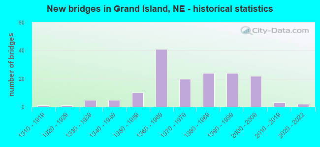
- New bridges - historical statistics
- 11910-1919
- 11920-1929
- 51930-1939
- 51940-1949
- 101950-1959
- 411960-1969
- 201970-1979
- 241980-1989
- 241990-1999
- 222000-2009
- 32010-2019
- 22020-2022
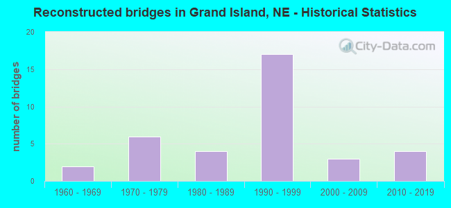
- Reconstructed bridges - Historical Statistics
- 21960-1969
- 61970-1979
- 41980-1989
- 171990-1999
- 32000-2009
- 42010-2019
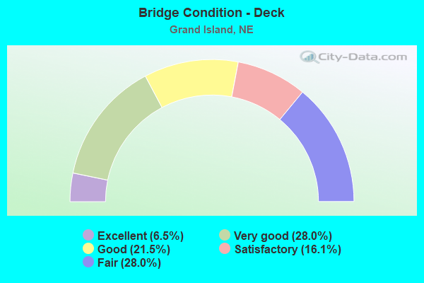
- Bridge Condition - Deck
- 6.5%Excellent
- 28.0%Very good
- 21.5%Good
- 16.1%Satisfactory
- 28.0%Fair
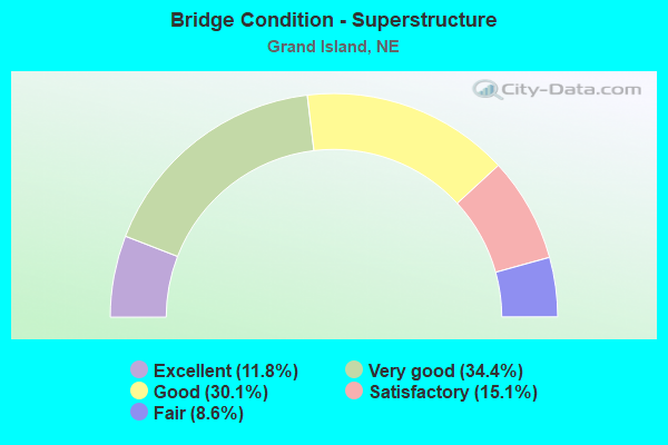
- Bridge Condition - Superstructure
- 11.8%Excellent
- 34.4%Very good
- 30.1%Good
- 15.1%Satisfactory
- 8.6%Fair
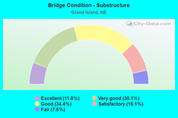
- Bridge Condition - Substructure
- 11.8%Excellent
- 30.1%Very good
- 34.4%Good
- 16.1%Satisfactory
- 7.5%Fair
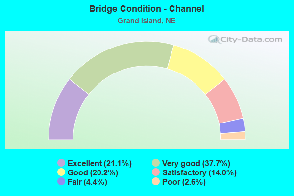
- Bridge Condition - Channel
- 21.1%Excellent
- 37.7%Very good
- 20.2%Good
- 14.0%Satisfactory
- 4.4%Fair
- 2.6%Poor
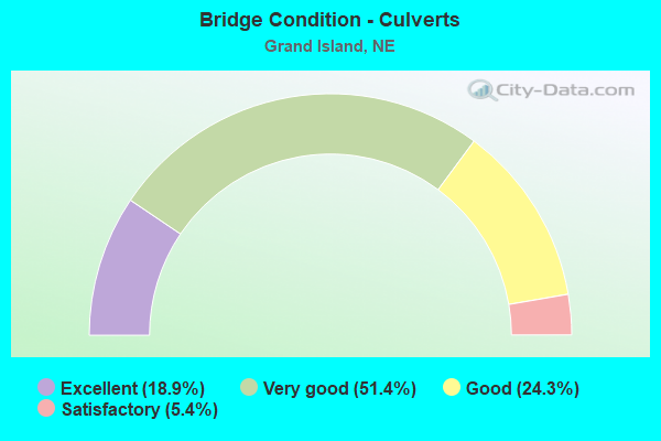
- Bridge Condition - Culverts
- 18.9%Excellent
- 51.4%Very good
- 24.3%Good
- 5.4%Satisfactory
Find on map >> Show street view
Structure Number: U1045W3904, Location: S. FRONT & SYCAMORE (Lat: 40.927200, Lng: -98.339500), Route carried "on" structure: City street W39, Year Built: 2020, Status: Open, Structure Length: 0.85m (2.79ft), Average Daily Traffic: 1,000 (year 2003), Truck Traffic: 10%, Average Future Daily Traffic: 1,450 (year 2033), Design Load: HL 93, Features Intersected: SYCAMORE STREET, Facility Carried by Structure: S. FRONT STREET
Minimum Vertical Clearance: 30+ m (98+ ft), Kilometerpoint: 0.000, Lanes on structure: 2, Lanes under structure: 2, Owner: City or Municipal Highway Agency, Approaching Roadway Width: 7.8m (25.6ft), Material/Design: Concrete, Design/Construction: Frame, Number Of Spans In Main Unit: 1, Length of Maximum Span: 8.5m (27.9ft), Curb or Sidewalk Widths: Left: 2.4m (7.9ft), Right: 0.8m (2.6ft), Curb-To-Curb Width: 7.8m (25.6ft), Out-to-Out Width: 11.7m (38.4ft)
Condition: Deck: Excellent, Superstructure: Excellent, Substructure: Excellent, Operating Rating: 74.0 metric tons, Method Used To Determine Operating Rating: Load and Resistance Factor (LRFR), Inventory Rating: 57.0 metric tons, Method Used To Determine Inventory Rating: Load and Resistance Factor (LRFR), Structural Evaluation: Superior to present desirable criteria, Deck Geometry: Meets minimum limits, Underclear: High priority of corrective action, Approach Roadway Alignment: Equal to present minimum criteria, Length Of Structure Improvement: 0.94m (3.08ft), Designated Inspection Frequency: Every 24 months, Inspection Date: April 2021, Deck Structure Type: Concrete Cast-file-Place, Wearing Surface/Protective System: Wearing Surface: Monolithic Concrete
Find on map >> Show street view
Structure Number: U1045W3906, Location: IND OVR & SYCAMORE (Lat: 40.927600, Lng: -98.339800), Route carried "on" structure: City street W39, Year Built: 1950, Status: Open, Structure Length: 0.94m (3.08ft), Average Daily Traffic: 65 (year 2013), Truck Traffic: 3%, Average Future Daily Traffic: 115 (year 2033), Design Load: HS 20, Features Intersected: SYCAMORE STREET, Facility Carried by Structure: INDUSTRY OVERPASS
Minimum Vertical Clearance: 30+ m (98+ ft), Kilometerpoint: 0.000, Lanes on structure: 2, Lanes under structure: 2, Owner: City or Municipal Highway Agency, Approaching Roadway Width: 7.6m (24.9ft), Material/Design: Concrete, Design/Construction: Frame, Number Of Spans In Main Unit: 1, Length of Maximum Span: 9.4m (30.8ft), Curb or Sidewalk Widths: Left: 0.3m (1.0ft), Right: 2.1m (6.9ft), Curb-To-Curb Width: 7.6m (24.9ft), Out-to-Out Width: 9.8m (32.2ft)
Condition: Deck: Fair, Superstructure: Very good, Substructure: Very good, Operating Rating: 45.0 metric tons, Method Used To Determine Operating Rating: Load Factor (LF), Inventory Rating: 26.0 metric tons, Method Used To Determine Inventory Rating: Load Factor (LF), Structural Evaluation: Equal to present minimum criteria, Deck Geometry: Equal to present minimum criteria, Underclear: High priority of corrective action, Approach Roadway Alignment: High priority of corrective action, Length Of Structure Improvement: 0.94m (3.08ft), Designated Inspection Frequency: Every 24 months, Inspection Date: April 2021, Deck Structure Type: Concrete Cast-file-Place, Wearing Surface/Protective System: Wearing Surface: Monolithic Concrete
Find on map >> Show street view
Structure Number: S030 31293, Location: JCT US30/281 GRAND ISLAND (Lat: 40.914000, Lng: -98.383300), Route carried "under" structure: US 281, Year Built: 1986, Structure Length: 0. m, Average Daily Traffic: 23,030 (year 2013), Truck Traffic: 9%, Features Intersected: US-281/N-2, Facility Carried by Structure: US30
Minimum Vertical Clearance: 5.18m (16.99ft), Kilometerpoint: 11.151, Lanes on structure: 4, Lanes under structure: 4, Material/Design: Steel continuous, Design/Construction: Stringer/Multi-beam, Length of Maximum Span: 28.7m (94.2ft)
Find on map >> Show street view
Structure Number: S030 31379, Location: IN GRAND ISLAND (Lat: 40.915800, Lng: -98.367900), Route carried "under" structure: City street P37, Year Built: 1985, Structure Length: 0. m, Average Daily Traffic: 1,500 (year 1997), Truck Traffic: 10%, Features Intersected: BLAINE ST, Facility Carried by Structure: US30
Minimum Vertical Clearance: 6.45m (21.16ft), Kilometerpoint: 0.000, Lanes on structure: 2, Lanes under structure: 2, Material/Design: Steel continuous, Design/Construction: Stringer/Multi-beam, Length of Maximum Span: 21.6m (70.9ft)
Find on map >> Show street view
Structure Number: S030 31389, Location: IN GRAND ISLAND (Lat: 40.915600, Lng: -98.366600), Route carried "under" structure: City street A20, Year Built: 1985, Structure Length: 0. m, Average Daily Traffic: 4,080 (year 2006), Features Intersected: UPRR/W 3RD/ARTHUR ST, Facility Carried by Structure: US30
Minimum Vertical Clearance: 7.97m (26.15ft), Kilometerpoint: 0.000, Lanes on structure: 4, Lanes under structure: 4, Material/Design: Steel continuous, Design/Construction: Stringer/Multi-beam, Length of Maximum Span: 46.0m (150.9ft)
Find on map >> Show street view
Structure Number: S030 31389, Location: IN GRAND ISLAND (Lat: 40.915600, Lng: -98.366600), Route carried "under" structure: City street I37, Year Built: 1985, Structure Length: 0. m, Average Daily Traffic: 500 (year 2006), Features Intersected: UPRR/W 3RD/ARTHUR ST, Facility Carried by Structure: US30
Minimum Vertical Clearance: 7.97m (26.15ft), Kilometerpoint: 0.000, Lanes on structure: 4, Lanes under structure: 4, Material/Design: Steel continuous, Design/Construction: Stringer/Multi-beam, Length of Maximum Span: 46.0m (150.9ft)
Find on map >> Show street view
Structure Number: S030 31593L, Location: IN GRAND ISLAND (Lat: 40.927500, Lng: -98.333200), Route carried "under" structure: US 30R, Year Built: 1994, Structure Length: 0. m, Average Daily Traffic: 6,835 (year 2008), Truck Traffic: 4%, Features Intersected: BNSF RR 083-084-B, Facility Carried by Structure: BNSF RR
Minimum Vertical Clearance: 9.60m (31.50ft), Kilometerpoint: 50.844, Lanes on structure: 2, Lanes under structure: 2, Material/Design: Prestressed concrete, Design/Construction: Stringer/Multi-beam, Length of Maximum Span: 21.3m (69.9ft)
Find on map >> Show street view
Structure Number: S030 31593R, Location: IN GRAND ISLAND (Lat: 40.926700, Lng: -98.332300), Route carried "under" structure: US 30, Year Built: 1996, Structure Length: 0. m, Average Daily Traffic: 6,650 (year 2008), Truck Traffic: 4%, Features Intersected: BNSF RR 083-084-B, Facility Carried by Structure: BNSF RR
Minimum Vertical Clearance: 9.60m (31.50ft), Kilometerpoint: 50.844, Lanes under structure: 2, Material/Design: Prestressed concrete, Design/Construction: Stringer/Multi-beam, Length of Maximum Span: 21.3m (69.9ft)
Find on map >> Show street view
Structure Number: S080 3121, Location: HASTINGS INTRCHG (Lat: 40.820000, Lng: -98.378600), Route carried "under" structure: Ramp Interstate 80, Year Built: 1962, Structure Length: 0. m, Average Daily Traffic: 8,600 (year 2006), Features Intersected: I80, Facility Carried by Structure: SB-US34/US281
Minimum Vertical Clearance: 5.05m (16.57ft), Kilometerpoint: 0.000, Lanes on structure: 6, Lanes under structure: 6, Material/Design: Prestressed concrete continuous, Design/Construction: Stringer/Multi-beam, Length of Maximum Span: 39.3m (128.9ft)
Find on map >> Show street view
Structure Number: S080 3121, Location: HASTINGS INTRCHG (Lat: 40.820000, Lng: -98.378600), Route carried "under" structure: US 34, Year Built: 1962, Structure Length: 0. m, Average Daily Traffic: 6,645 (year 2006), Truck Traffic: 17%, Features Intersected: I80
Minimum Vertical Clearance: 5.15m (16.90ft), Kilometerpoint: 36.444, Lanes on structure: 4, Lanes under structure: 6, Material/Design: Prestressed concrete continuous, Design/Construction: Stringer/Multi-beam, Length of Maximum Span: 39.3m (128.9ft)
Find on map >> Show street view
Structure Number: S080 3121, Location: HASTINGS INTRCHG (Lat: 40.820000, Lng: -98.378600), Route carried "under" structure: Ramp Interstate 80, Year Built: 1962, Structure Length: 0. m, Average Daily Traffic: 8,600 (year 2006), Features Intersected: I80, Facility Carried by Structure: SB-US34/US281
Minimum Vertical Clearance: 5.05m (16.57ft), Kilometerpoint: 0.000, Lanes on structure: 6, Lanes under structure: 6, Material/Design: Prestressed concrete continuous, Design/Construction: Stringer/Multi-beam, Length of Maximum Span: 39.3m (128.9ft)
Find on map >> Show street view
Structure Number: S080 3121, Location: HASTINGS INTRCHG (Lat: 40.820000, Lng: -98.378600), Route carried "under" structure: Interstate 80, Year Built: 1962, Structure Length: 0. m, Average Daily Traffic: 8,600 (year 2006), Features Intersected: I80, Facility Carried by Structure: SB-US34/US281
Minimum Vertical Clearance: 5.15m (16.90ft), Kilometerpoint: 0.000, Lanes on structure: 6, Lanes under structure: 6, Material/Design: Prestressed concrete continuous, Design/Construction: Stringer/Multi-beam, Length of Maximum Span: 39.3m (128.9ft)
Find on map >> Show street view
Structure Number: S080 31211, Location: HASTINGS INTRCHG (Lat: 40.820100, Lng: -98.378300), Route carried "under" structure: Ramp Interstate 80, Year Built: 1962, Structure Length: 0. m, Average Daily Traffic: 8,600 (year 2006), Features Intersected: I80, Facility Carried by Structure: NB-US34/US281
Minimum Vertical Clearance: 5.05m (16.57ft), Kilometerpoint: 0.000, Lanes on structure: 6, Lanes under structure: 6, Material/Design: Prestressed concrete continuous, Design/Construction: Stringer/Multi-beam, Length of Maximum Span: 39.3m (128.9ft)
Find on map >> Show street view
Structure Number: S080 31211, Location: HASTINGS INTRCHG (Lat: 40.820100, Lng: -98.378300), Route carried "under" structure: US 34, Year Built: 1962, Structure Length: 0. m, Average Daily Traffic: 6,645 (year 2006), Truck Traffic: 17%, Features Intersected: I80
Minimum Vertical Clearance: 5.23m (17.16ft), Kilometerpoint: 36.444, Lanes on structure: 4, Lanes under structure: 6, Material/Design: Prestressed concrete continuous, Design/Construction: Stringer/Multi-beam, Length of Maximum Span: 39.3m (128.9ft)
Find on map >> Show street view
Structure Number: S080 31211, Location: HASTINGS INTRCHG (Lat: 40.820100, Lng: -98.378300), Route carried "under" structure: Interstate 80, Year Built: 1962, Structure Length: 0. m, Average Daily Traffic: 8,600 (year 2006), Features Intersected: I80, Facility Carried by Structure: NB-US34/US281
Minimum Vertical Clearance: 5.05m (16.57ft), Kilometerpoint: 0.000, Lanes on structure: 6, Lanes under structure: 6, Material/Design: Prestressed concrete continuous, Design/Construction: Stringer/Multi-beam, Length of Maximum Span: 39.3m (128.9ft)
Find on map >> Show street view
Structure Number: S080 31414, Location: LOCUST ST INTRCHG (Lat: 40.825700, Lng: -98.340400), Route carried "under" structure: County highway 2235, Year Built: 2002, Structure Length: 0. m, Average Daily Traffic: 1,630 (year 2007), Features Intersected: I80&EB I80 ENTRANCE RMP
Minimum Vertical Clearance: 5.25m (17.22ft), Kilometerpoint: 1.629, Lanes on structure: 4, Lanes under structure: 5, Material/Design: Prestressed concrete continuous, Design/Construction: Stringer/Multi-beam, Length of Maximum Span: 41.1m (134.8ft)
Find on map >> Show street view
Structure Number: S080 31414, Location: LOCUST ST INTRCHG (Lat: 40.825700, Lng: -98.340400), Route carried "under" structure: Interstate 80, Year Built: 2002, Structure Length: 0. m, Average Daily Traffic: 8,600 (year 2007), Features Intersected: I80&EB I80 ENTRANCE RMP, Facility Carried by Structure: FAS 2235
Minimum Vertical Clearance: 5.02m (16.47ft), Kilometerpoint: 50.556, Lanes on structure: 5, Lanes under structure: 5, Material/Design: Prestressed concrete continuous, Design/Construction: Stringer/Multi-beam, Length of Maximum Span: 41.1m (134.8ft)
Find on map >> Show street view
Structure Number: S080 31414, Location: LOCUST ST INTRCHG (Lat: 40.825700, Lng: -98.340400), Route carried "under" structure: Ramp Interstate 80, Year Built: 2002, Structure Length: 0. m, Average Daily Traffic: 8,600 (year 2007), Features Intersected: I80&EB I80 ENTRANCE RMP, Facility Carried by Structure: FAS 2235
Minimum Vertical Clearance: 5.02m (16.47ft), Kilometerpoint: 50.556, Lanes on structure: 1, Lanes under structure: 5, Material/Design: Prestressed concrete continuous, Design/Construction: Stringer/Multi-beam, Length of Maximum Span: 41.1m (134.8ft)
Find on map >> Show street view
Structure Number: S080 31619, Location: 2W GRAND ISLAND INTRCHG (Lat: 40.821000, Lng: -98.301800), Route carried "under" structure: Interstate 80, Year Built: 1965, Structure Length: 0. m, Average Daily Traffic: 20,695 (year 2013), Truck Traffic: 37%, Features Intersected: I80, Facility Carried by Structure: COUNTY HIGHWAY
Minimum Vertical Clearance: 5.05m (16.57ft), Kilometerpoint: 50.886, Lanes on structure: 4, Lanes under structure: 4, Material/Design: Prestressed concrete, Design/Construction: Stringer/Multi-beam, Length of Maximum Span: 21.3m (69.9ft)
Find on map >> Show street view
Structure Number: S281 0689, Location: IN GRAND ISLAND (Lat: 40.908500, Lng: -98.383200), Route carried "under" structure: City street 5400, Year Built: 1961, Structure Length: 0. m, Average Daily Traffic: 3,115 (year 2013), Features Intersected: OLD US30/UPRR, Facility Carried by Structure: US281/N2
Minimum Vertical Clearance: 7.29m (23.92ft), Kilometerpoint: 16.293, Lanes on structure: 2, Lanes under structure: 2, Material/Design: Steel continuous, Design/Construction: Stringer/Multi-beam, Length of Maximum Span: 24.1m (79.1ft)
Find on map >> Show street view
Structure Number: S281 07202, Location: IN GRAND ISLAND (Lat: 40.953600, Lng: -98.384400), Route carried "under" structure: State highway 2, Year Built: 1983, Structure Length: 0. m, Average Daily Traffic: 4,535 (year 2012), Truck Traffic: 7%, Features Intersected: N2
Minimum Vertical Clearance: 7.95m (26.08ft), Kilometerpoint: 57.288, Lanes on structure: 4, Lanes under structure: 4, Material/Design: Steel continuous, Design/Construction: Stringer/Multi-beam, Length of Maximum Span: 24.4m (80.1ft)
Find on map >> Show street view
Structure Number: U104511625, Location: CAPITAL AVE GRAND ISLAND (Lat: 40.945700, Lng: -98.348100), Route carried "under" structure: City street 5430, Year Built: 1994, Structure Length: 0. m, Average Daily Traffic: 5,625 (year 2008), Features Intersected: BNSF RR 083-073-N, Facility Carried by Structure: BNSF RR
Minimum Vertical Clearance: 4.72m (15.49ft), Kilometerpoint: 16.670, Lanes on structure: 2, Lanes under structure: 2, Material/Design: Prestressed concrete, Design/Construction: Stringer/Multi-beam, Length of Maximum Span: 25.9m (85.0ft)
Find on map >> Show street view
Structure Number: U1045G163, Location: 18TH ST GRAND ISLAND (Lat: 40.942500, Lng: -98.344600), Route carried "under" structure: City street G16, Year Built: 1994, Structure Length: 0. m, Average Daily Traffic: 700 (year 2003), Truck Traffic: 1%, Features Intersected: BNSF RR 083-074-V, Facility Carried by Structure: BNSF RR
Minimum Vertical Clearance: 6.40m (21.00ft), Kilometerpoint: 0.000, Lanes on structure: 2, Lanes under structure: 2, Material/Design: Prestressed concrete, Design/Construction: Stringer/Multi-beam, Length of Maximum Span: 15.2m (49.9ft)
Find on map >> Show street view
Structure Number: U1045I183, Location: 4TH ST GRAND ISLAND (Lat: 40.930800, Lng: -98.336100), Route carried "under" structure: City street 5424, Year Built: 1994, Structure Length: 0. m, Average Daily Traffic: 6,220 (year 2008), Features Intersected: BNSF RR 083-080-Y, Facility Carried by Structure: BNSF RR
Minimum Vertical Clearance: 7.06m (23.16ft), Kilometerpoint: 16.311, Lanes on structure: 1, Lanes under structure: 2, Material/Design: Prestressed concrete, Design/Construction: Stringer/Multi-beam, Length of Maximum Span: 21.3m (69.9ft)
Find on map >> Show street view
Structure Number: U1045J3905, Location: GRAND ISLAND S FRONT&EDDY (Lat: 40.923600, Lng: -98.348300), Route carried "under" structure: City street 5413, Year Built: 1950, Structure Length: 0. m, Average Daily Traffic: 10,060 (year 2013), Truck Traffic: 2%, Features Intersected: EDDY ST, Facility Carried by Structure: UPRR/S FRONT ST
Minimum Vertical Clearance: 4.24m (13.91ft), Kilometerpoint: 16.195, Lanes on structure: 2, Lanes under structure: 4, Material/Design: Steel, Design/Construction: Stringer/Multi-beam, Length of Maximum Span: 16.8m (55.1ft)
Find on map >> Show street view
Structure Number: U1045P163, Location: 10TH ST GRAND ISLAND (Lat: 40.936100, Lng: -98.339900), Route carried "under" structure: City street 5428, Year Built: 1994, Structure Length: 0. m, Average Daily Traffic: 3,435 (year 2008), Features Intersected: BNSF RR 083-076-J, Facility Carried by Structure: BNSF RR
Minimum Vertical Clearance: 4.90m (16.08ft), Kilometerpoint: 16.275, Lanes on structure: 2, Lanes under structure: 2, Material/Design: Prestressed concrete, Design/Construction: Stringer/Multi-beam, Length of Maximum Span: 16.8m (55.1ft)
Find on map >> Show street view
Structure Number: U1045W3904, Location: S. FRONT & SYCAMORE (Lat: 40.927200, Lng: -98.339500), Route carried "under" structure: City street 5419, Year Built: 2020, Structure Length: 0. m, Average Daily Traffic: 6,960 (year 2013), Features Intersected: SYCAMORE STREET, Facility Carried by Structure: S. FRONT STREET
Minimum Vertical Clearance: 4.94m (16.21ft), Kilometerpoint: 16.126, Lanes on structure: 2, Lanes under structure: 2, Material/Design: Concrete, Design/Construction: Frame, Length of Maximum Span: 8.5m (27.9ft)
Find on map >> Show street view
Structure Number: U1045W3905, Location: GRAND ISLAND FRONT@SYCMOR (Lat: 40.927600, Lng: -98.339800), Route carried "under" structure: City street 5419, Year Built: 1950, Structure Length: 0. m, Average Daily Traffic: 6,960 (year 2013), Features Intersected: SYCAMORE ST 817-620-Y, Facility Carried by Structure: UPRR
Minimum Vertical Clearance: 4.26m (13.98ft), Kilometerpoint: 16.130, Lanes on structure: 2, Lanes under structure: 2, Material/Design: Steel, Design/Construction: Stringer/Multi-beam, Length of Maximum Span: 9.4m (30.8ft)
Find on map >> Show street view
Structure Number: U1045W3906, Location: IND OVR & SYCAMORE (Lat: 40.927600, Lng: -98.339800), Route carried "under" structure: City street 5419, Year Built: 1950, Structure Length: 0. m, Average Daily Traffic: 6,960 (year 2013), Features Intersected: SYCAMORE STREET, Facility Carried by Structure: INDUSTRY OVERPASS
Minimum Vertical Clearance: 4.27m (14.01ft), Kilometerpoint: 16.132, Lanes on structure: 2, Lanes under structure: 2, Material/Design: Concrete, Design/Construction: Frame, Length of Maximum Span: 9.4m (30.8ft)