Bridge Statistics for Golden Valley, Minnesota (MN)
Condition, Traffic, Stress, Structural Evaluation, Project Costs
- National Bridge Inventory (NBI) Statistics
- 117Number of bridges
- 1,335ft / 407mTotal length
- $6,235,996,000Total costs
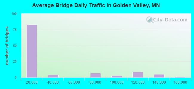
- 2,990,545Total average daily traffic
- 91,621Total average daily truck traffic
- National Bridge Inventory (NBI) Registered Bridges for Golden Valley
- No street view available for this location
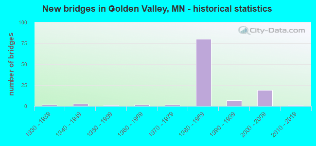
- New bridges - historical statistics
- 21930-1939
- 31940-1949
- 11950-1959
- 21960-1969
- 21970-1979
- 801980-1989
- 71990-1999
- 192000-2009
- 12010-2019
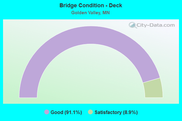
- Bridge Condition - Deck
- 91.1%Good
- 8.9%Satisfactory
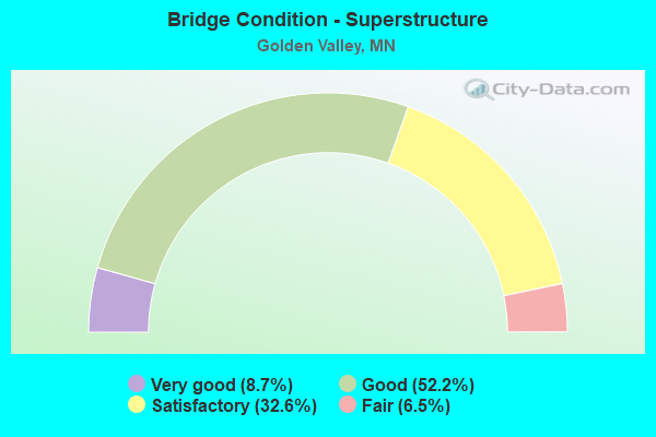
- Bridge Condition - Superstructure
- 8.7%Very good
- 52.2%Good
- 32.6%Satisfactory
- 6.5%Fair
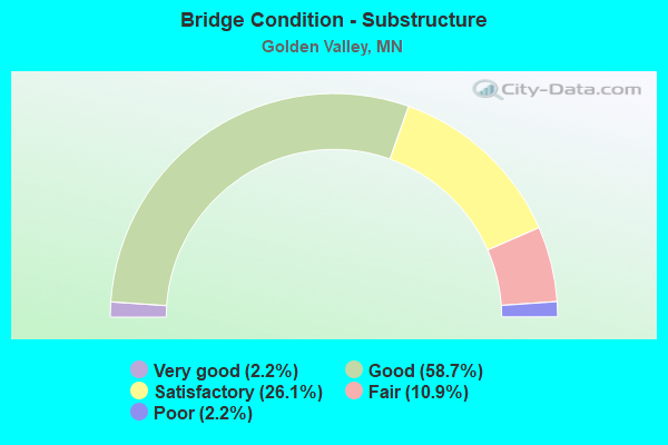
- Bridge Condition - Substructure
- 2.2%Very good
- 58.7%Good
- 26.1%Satisfactory
- 10.9%Fair
- 2.2%Poor
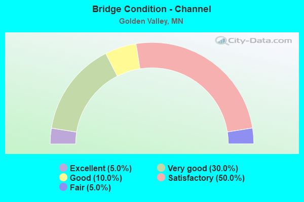
- Bridge Condition - Channel
- 5.0%Excellent
- 30.0%Very good
- 10.0%Good
- 50.0%Satisfactory
- 5.0%Fair
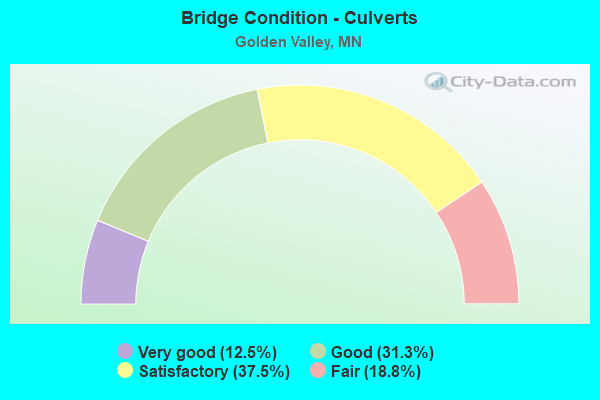
- Bridge Condition - Culverts
- 12.5%Very good
- 31.3%Good
- 37.5%Satisfactory
- 18.8%Fair
Find on map >> Show street view
Structure Number: 27A71, Location: 1.7 MI N OF JCT TH 55 (Lat: 45.008675, Lng: -93.349297), Route carried "on" structure: , Year Built: 2003, Status: Open, Structure Length: 24.82m (81.43ft), Features Intersected: TH 100; E FRT RD, Facility Carried by Structure: PEDESTRIAN
Lanes under structure: 16, Owner: City or Municipal Highway Agency, Skew: 1 degrees, Material/Design: Prestressed concrete, Design/Construction: Stringer/Multi-beam, Number Of Spans In Main Unit: 2, Number Of Approach Spans: 9, Length of Maximum Span: 22.6m (74.1ft), Out-to-Out Width: 4.6m (15.1ft)
Condition: Deck: Good, Superstructure: Good, Substructure: Good, Underclear: Meets minimum limits, Bridge Posting: Required (Relationship of Operating Rating to Maximum Legal Load: > 39.9% below), Designated Inspection Frequency: Every 24 months, Inspection Date: July 2021, Deck Structure Type: Concrete Cast-file-Place, Wearing Surface/Protective System: Wearing Surface: Monolithic Concrete, Deck Protection: Epoxy Coated Reinforcing
Find on map >> Show street view
Structure Number: 27J03, Location: 0.2 MI N OF CSAH 66 (Lat: 45.003247, Lng: -93.353775), Route carried "on" structure: City street 165, Year Built: 1993, Status: Open, Structure Length: 0.79m (2.59ft), Average Daily Traffic: 100 (year 1995), Average Future Daily Traffic: 100 (year 2029), Design Load: HS 20, Features Intersected: BASSETT CREEK
Minimum Vertical Clearance: 30+ m (98+ ft), Kilometerpoint: 0.000, Lanes on structure: 2, Owner: City or Municipal Highway Agency, Approaching Roadway Width: 8.8m (28.9ft), Material/Design: Concrete, Design/Construction: Culvert, Number Of Spans In Main Unit: 1, Length of Maximum Span: 7.3m (24.0ft)
Condition: Channel: Very good, Culverts: Good, Operating Rating: 49.0 metric tons, Method Used To Determine Operating Rating: Field evaluation and documented engineering judgment, Inventory Rating: 32.7 metric tons, Method Used To Determine Inventory Rating: Field evaluation and documented engineering judgment, Structural Evaluation: Better than present minimum criteria, Waterway Adequacy: Superior to present desirable criteria, Approach Roadway Alignment: Equal to present desirable criteria, Designated Inspection Frequency: Every 48 months, Inspection Date: October 2018
Find on map >> Show street view
Structure Number: 27J16, Location: 0.3 MI E OF JCT CSAH 102 (Lat: 44.996433, Lng: -93.354867), Route carried "on" structure: City street 179, Year Built: 1999, Status: Open, Structure Length: 0.84m (2.76ft), Average Daily Traffic: 250 (year 1974), Average Future Daily Traffic: 250 (year 2029), Design Load: HS 25 or greater, Features Intersected: BASSETT CREEK
Minimum Vertical Clearance: 30+ m (98+ ft), Kilometerpoint: 0.000, Lanes on structure: 2, Owner: City or Municipal Highway Agency, Approaching Roadway Width: 8.8m (28.9ft), Material/Design: Concrete, Design/Construction: Culvert, Number Of Spans In Main Unit: 2, Length of Maximum Span: 3.5m (11.5ft)
Condition: Channel: Satisfactory, Culverts: Good, Operating Rating: 68.6 metric tons, Method Used To Determine Operating Rating: Assigned ratings based on Allowable Stress Design (ASD) reported in metric tons, Inventory Rating: 40.8 metric tons, Method Used To Determine Inventory Rating: Assigned ratings based on Allowable Stress Design (ASD) reported in metric tons, Structural Evaluation: Better than present minimum criteria, Waterway Adequacy: Superior to present desirable criteria, Approach Roadway Alignment: Equal to present desirable criteria, Designated Inspection Frequency: Every 24 months, Inspection Date: October 2021
Find on map >> Show street view
Structure Number: 27J21, Location: 0.1 MI W OF JCT CSAH 102 (Lat: 44.992794, Lng: -93.362672), Route carried "on" structure: City street 94, Year Built: 2000, Status: Open, Structure Length: 0.66m (2.17ft), Average Daily Traffic: 750 (year 2017), Average Future Daily Traffic: 750 (year 2039), Design Load: HS 25 or greater, Features Intersected: BASSETT CREEK
Minimum Vertical Clearance: 30+ m (98+ ft), Kilometerpoint: 0.000, Lanes on structure: 2, Owner: City or Municipal Highway Agency, Approaching Roadway Width: 9.8m (32.2ft), Material/Design: Concrete, Design/Construction: Culvert, Number Of Spans In Main Unit: 2, Length of Maximum Span: 3.0m (9.8ft)
Condition: Channel: Satisfactory, Culverts: Very good, Operating Rating: 68.6 metric tons, Method Used To Determine Operating Rating: Assigned rating based on Load Factor Design (LFD) reported in metric tons, Inventory Rating: 40.8 metric tons, Method Used To Determine Inventory Rating: Assigned rating based on Load Factor Design (LFD) reported in metric tons, Structural Evaluation: Equal to present desirable criteria, Waterway Adequacy: Superior to present desirable criteria, Approach Roadway Alignment: Equal to present desirable criteria, Designated Inspection Frequency: Every 48 months, Inspection Date: October 2019
Find on map >> Show street view
Structure Number: 27J38, Location: 0.4 MI N OF JCT CSAH 66 (Lat: 45.003739, Lng: -93.331314), Route carried "on" structure: City street 162, Year Built: 2007, Status: Open, Structure Length: 0.79m (2.59ft), Average Daily Traffic: 1 (year 2018), Average Future Daily Traffic: 1 (year 2038), Features Intersected: BASSETT CREEK
Minimum Vertical Clearance: 30+ m (98+ ft), Kilometerpoint: 0.000, Lanes on structure: 2, Owner: City or Municipal Highway Agency, Approaching Roadway Width: 7.3m (24.0ft), Material/Design: Steel, Design/Construction: Culvert, Number Of Spans In Main Unit: 2, Length of Maximum Span: 3.5m (11.5ft)
Condition: Channel: Satisfactory, Culverts: Fair, Operating Rating: 39.5 metric tons, Method Used To Determine Operating Rating: Load and Resistance Factor Rating (LRFR) rating reported by rating factor(RF) method using HL-93 loadings, Inventory Rating: 30.5 metric tons, Method Used To Determine Inventory Rating: Load and Resistance Factor Rating (LRFR) rating reported by rating factor(RF) method using HL-93 loadings, Structural Evaluation: Somewhat better than minimum adequacy, Waterway Adequacy: Equal to present desirable criteria, Approach Roadway Alignment: Equal to present desirable criteria, Designated Inspection Frequency: Every 24 months, Inspection Date: October 2020
Find on map >> Show street view
Structure Number: 27J68, Location: 0.1 MI E OF WINNETKA AVE (Lat: 44.989028, Lng: -93.378822), Route carried "on" structure: City street 412, Year Built: 2017, Status: Open, Structure Length: 0.84m (2.76ft), Average Daily Traffic: 2,850 (year 2017), Average Future Daily Traffic: 3,570 (year 2037), Design Load: HL 93, Features Intersected: BASSETT CREEK
Minimum Vertical Clearance: 30+ m (98+ ft), Kilometerpoint: 0.000, Lanes on structure: 2, Owner: City or Municipal Highway Agency, Approaching Roadway Width: 14.6m (47.9ft), Skew: 4 degrees, Material/Design: Concrete, Design/Construction: Culvert, Number Of Spans In Main Unit: 2, Length of Maximum Span: 2.4m (7.9ft)
Condition: Channel: Excellent, Culverts: Very good, Operating Rating: 42.1 metric tons, Method Used To Determine Operating Rating: Assigned ratings based on Load and Resistance Factor Design (LRFD) reported by rating factor (RF) using HL93 loadings, Inventory Rating: 32.4 metric tons, Method Used To Determine Inventory Rating: Assigned ratings based on Load and Resistance Factor Design (LRFD) reported by rating factor (RF) using HL93 loadings, Structural Evaluation: Equal to present desirable criteria, Waterway Adequacy: Superior to present desirable criteria, Approach Roadway Alignment: Equal to present desirable criteria, Designated Inspection Frequency: Every 48 months, Inspection Date: October 2021
Find on map >> Show street view
Structure Number: 5642, Location: 1.7 MI N OF JCT TH 55 (Lat: 45.008658, Lng: -93.348831), Route carried "on" structure: State highway 100, Year Built: 1936, Status: Open, Structure Length: 0.68m (2.23ft), Average Daily Traffic: 101,000 (year 2019), Truck Traffic: 4%, Average Future Daily Traffic: 91,000 (year 2039), Design Load: H 15, Features Intersected: Bassett Creek
Minimum Vertical Clearance: 30+ m (98+ ft), Kilometerpoint: 0.000, Lanes on structure: 4, Base Highway Network: Yes, Owner: State Highway Agency, Approaching Roadway Width: 21.9m (71.9ft), Skew: 30 degrees, Material/Design: Concrete, Design/Construction: Culvert, Number Of Spans In Main Unit: 2, Length of Maximum Span: 3.0m (9.8ft)
Condition: Channel: Satisfactory, Culverts: Satisfactory, Operating Rating: 39.2 metric tons, Method Used To Determine Operating Rating: Assigned ratings based on Allowable Stress Design (ASD) reported in metric tons, Inventory Rating: 29.4 metric tons, Method Used To Determine Inventory Rating: Assigned ratings based on Allowable Stress Design (ASD) reported in metric tons, Structural Evaluation: Equal to present minimum criteria, Waterway Adequacy: Equal to present desirable criteria, Approach Roadway Alignment: Equal to present desirable criteria, Length Of Structure Improvement: 0.34m (1.12ft), Designated Inspection Frequency: Every 24 months, Underwater Inspection Frequency: Every 60 months, Inspection Date: August 2021, Underwater Inspection Date: July 2020, Bridge Improvement Cost: $118,000,000, Roadway Improvement Cost: $5,000,000, Total Project Cost: $79,000,000
Find on map >> Show street view
Structure Number: 5642A, Location: 1.7 MI N OF JCT TH 55 (Lat: 45.009022, Lng: -93.349425), Route carried "on" structure: ServiceState highway 100, Year Built: 2000, Status: Open, Structure Length: 0.70m (2.30ft), Average Daily Traffic: 101,000 (year 2019), Truck Traffic: 4%, Average Future Daily Traffic: 1 (year 2039), Design Load: HS 25 or greater, Features Intersected: Bassett Creek
Minimum Vertical Clearance: 30+ m (98+ ft), Kilometerpoint: 0.000, Lanes on structure: 2, Base Highway Network: Yes, Owner: State Highway Agency, Approaching Roadway Width: 8.4m (27.6ft), Material/Design: Concrete, Design/Construction: Culvert, Number Of Spans In Main Unit: 2, Length of Maximum Span: 3.0m (9.8ft)
Condition: Channel: Satisfactory, Culverts: Good, Operating Rating: 68.6 metric tons, Method Used To Determine Operating Rating: Assigned rating based on Load Factor Design (LFD) reported in metric tons, Inventory Rating: 40.8 metric tons, Method Used To Determine Inventory Rating: Assigned rating based on Load Factor Design (LFD) reported in metric tons, Structural Evaluation: Better than present minimum criteria, Waterway Adequacy: Equal to present desirable criteria, Approach Roadway Alignment: Equal to present desirable criteria, Designated Inspection Frequency: Every 48 months, Underwater Inspection Frequency: Every 60 months, Inspection Date: July 2019, Underwater Inspection Date: July 2020
Find on map >> Show street view
Structure Number: 5891, Location: 0.6 Mi East of Jct TH 100 (Lat: 44.984297, Lng: -93.337672), Route carried "on" structure: State highway 55, Year Built: 1942, Status: Open, Structure Length: 7.24m (23.75ft), Average Daily Traffic: 28,146 (year 2019), Truck Traffic: 3%, Average Future Daily Traffic: 27,500 (year 2039), Design Load: HS 20, Features Intersected: CP RAIL
Minimum Vertical Clearance: 30+ m (98+ ft), Kilometerpoint: 0.000, Lanes on structure: 4, Base Highway Network: Yes, Owner: State Highway Agency, Approaching Roadway Width: 24.4m (80.1ft), Skew: 23 degrees, Material/Design: Steel continuous, Design/Construction: Stringer/Multi-beam, Number Of Spans In Main Unit: 6, Length of Maximum Span: 11.9m (39.0ft), Curb or Sidewalk Widths: Left: 1.8m (5.9ft), Right: 1.8m (5.9ft), Curb-To-Curb Width: 22.6m (74.1ft), Out-to-Out Width: 29.5m (96.8ft)
Condition: Deck: Satisfactory, Superstructure: Fair, Substructure: Satisfactory, Operating Rating: 51.9 metric tons, Method Used To Determine Operating Rating: Load Factor (LF), Inventory Rating: 29.6 metric tons, Method Used To Determine Inventory Rating: Load Factor (LF), Structural Evaluation: Somewhat better than minimum adequacy, Deck Geometry: Superior to present desirable criteria, Underclear: Meets minimum limits, Approach Roadway Alignment: Equal to present desirable criteria, Designated Inspection Frequency: Every 24 months, Inspection Date: June 2021, Deck Structure Type: Concrete Cast-file-Place, Wearing Surface/Protective System: Wearing Surface: Low Slump Concrete, Deck Protection: Other
Find on map >> Show street view
Structure Number: 5908, Location: 1.5 MI E OF JCT TH 100 (Lat: 44.984058, Lng: -93.319153), Route carried "on" structure: State highway 55, Year Built: 1947, Status: Open, Structure Length: 0.68m (2.23ft), Average Daily Traffic: 18,308 (year 2019), Truck Traffic: 3%, Average Future Daily Traffic: 18,200 (year 2039), Design Load: H 15, Features Intersected: Bassett Creek
Minimum Vertical Clearance: 30+ m (98+ ft), Kilometerpoint: 0.000, Lanes on structure: 4, Base Highway Network: Yes, Owner: State Highway Agency, Approaching Roadway Width: 21.6m (70.9ft), Skew: 20 degrees, Material/Design: Concrete, Design/Construction: Culvert, Number Of Spans In Main Unit: 2, Length of Maximum Span: 3.0m (9.8ft)
Condition: Channel: Satisfactory, Culverts: Fair, Operating Rating: 39.2 metric tons, Method Used To Determine Operating Rating: Assigned ratings based on Allowable Stress Design (ASD) reported in metric tons, Inventory Rating: 29.4 metric tons, Method Used To Determine Inventory Rating: Assigned ratings based on Allowable Stress Design (ASD) reported in metric tons, Structural Evaluation: Somewhat better than minimum adequacy, Waterway Adequacy: Equal to present desirable criteria, Approach Roadway Alignment: Equal to present desirable criteria, Designated Inspection Frequency: Every 24 months, Underwater Inspection Frequency: Every 60 months, Inspection Date: Febuary 2021, Underwater Inspection Date: July 2020
Find on map >> Show street view
Structure Number: 6247, Location: 0.5 MI W OF JCT CSAH 2 (Lat: 44.991536, Lng: -93.319528), Route carried "on" structure: City street 65, Year Built: 1930, Status: Open, Structure Length: 6.64m (21.78ft), Average Daily Traffic: 5,320 (year 2017), Average Future Daily Traffic: 5,320 (year 2034), Design Load: HS 25 or greater, Features Intersected: BNSF RR; BASSETT CREEK
Minimum Vertical Clearance: 30+ m (98+ ft), Kilometerpoint: 0.000, Lanes on structure: 2, Owner: City or Municipal Highway Agency, Approaching Roadway Width: 11.6m (38.1ft), Material/Design: Concrete continuous, Design/Construction: Slab, Number Of Spans In Main Unit: 7, Length of Maximum Span: 10.2m (33.5ft), Curb or Sidewalk Widths: Left: 2.4m (7.9ft), Right: 2.4m (7.9ft), Curb-To-Curb Width: 11.0m (36.1ft), Out-to-Out Width: 16.7m (54.8ft)
Condition: Deck: Good, Superstructure: Good, Substructure: Good, Channel: Very good, Operating Rating: 44.1 metric tons, Method Used To Determine Operating Rating: Load Factor (LF), Inventory Rating: 26.3 metric tons, Method Used To Determine Inventory Rating: Load Factor (LF), Structural Evaluation: Equal to present minimum criteria, Deck Geometry: Meets minimum limits, Underclear: Equal to present minimum criteria, Waterway Adequacy: Superior to present desirable criteria, Approach Roadway Alignment: Better than present minimum criteria, Length Of Structure Improvement: 1.74m (5.71ft), Designated Inspection Frequency: Every 24 months, Inspection Date: July 2021, Bridge Improvement Cost: $838,000,000, Roadway Improvement Cost: $55,000,000, Total Project Cost: $838,000,000, Deck Structure Type: Concrete Cast-file-Place, Wearing Surface/Protective System: Wearing Surface: Low Slump Concrete, Deck Protection: Epoxy Coated Reinforcing
Find on map >> Show street view
Structure Number: 6732, Location: 0.6 Mi East of Jct TH 16 (Lat: 44.984736, Lng: -93.388008), Route carried "on" structure: State highway 55, Year Built: 1951, Status: Open, Structure Length: 0.88m (2.89ft), Average Daily Traffic: 38,894 (year 2019), Truck Traffic: 4%, Average Future Daily Traffic: 38,000 (year 2039), Design Load: H 20, Features Intersected: BASSETT CREEK
Minimum Vertical Clearance: 30+ m (98+ ft), Kilometerpoint: 0.000, Lanes on structure: 4, Base Highway Network: Yes, Owner: State Highway Agency, Approaching Roadway Width: 34.7m (113.8ft), Skew: 12 degrees, Material/Design: Concrete, Design/Construction: Culvert, Number Of Spans In Main Unit: 1, Length of Maximum Span: 6.1m (20.0ft)
Condition: Channel: Satisfactory, Culverts: Satisfactory, Operating Rating: 39.2 metric tons, Method Used To Determine Operating Rating: Assigned ratings based on Allowable Stress Design (ASD) reported in metric tons, Inventory Rating: 29.4 metric tons, Method Used To Determine Inventory Rating: Assigned ratings based on Allowable Stress Design (ASD) reported in metric tons, Structural Evaluation: Equal to present minimum criteria, Waterway Adequacy: Equal to present desirable criteria, Approach Roadway Alignment: Equal to present desirable criteria, Designated Inspection Frequency: Every 24 months, Inspection Date: June 2021
Find on map >> Show street view
Structure Number: 91042, Location: 0.3 MI E OF JCT CSAH 102 (Lat: 44.999553, Lng: -93.354806), Route carried "on" structure: County highway 66, Year Built: 1963, Status: Open, Structure Length: 0.68m (2.23ft), Average Daily Traffic: 15,100 (year 2015), Truck Traffic: 3%, Average Future Daily Traffic: 15,100 (year 2039), Features Intersected: BASSETT CREEK
Minimum Vertical Clearance: 30+ m (98+ ft), Kilometerpoint: 0.000, Lanes on structure: 4, Owner: County Highway Agency, Approaching Roadway Width: 17.4m (57.1ft), Skew: 20 degrees, Material/Design: Concrete, Design/Construction: Culvert, Number Of Spans In Main Unit: 2, Length of Maximum Span: 3.0m (9.8ft), Curb or Sidewalk Widths: Left: 1.5m (4.9ft), Right: 2.4m (7.9ft)
Condition: Channel: Fair, Culverts: Satisfactory, Operating Rating: 63.9 metric tons, Method Used To Determine Operating Rating: Assigned ratings based on Allowable Stress Design (ASD) reported in metric tons, Inventory Rating: 42.0 metric tons, Method Used To Determine Inventory Rating: Assigned ratings based on Allowable Stress Design (ASD) reported in metric tons, Structural Evaluation: Equal to present minimum criteria, Waterway Adequacy: Equal to present desirable criteria, Approach Roadway Alignment: Better than present minimum criteria, Designated Inspection Frequency: Every 24 months, Inspection Date: May 2020
Find on map >> Show street view
Structure Number: 92638, Location: 0.3 MI S OF JCT TH 55 (Lat: 44.979531, Lng: -93.390464), Route carried "on" structure: City street 407, Year Built: 1969, Status: Open, Structure Length: 0.80m (2.62ft), Average Daily Traffic: 7,900 (year 2017), Average Future Daily Traffic: 7,900 (year 2039), Design Load: H 20, Features Intersected: BASSETT CREEK
Minimum Vertical Clearance: 30+ m (98+ ft), Kilometerpoint: 0.000, Lanes on structure: 2, Owner: City or Municipal Highway Agency, Approaching Roadway Width: 13.4m (44.0ft), Skew: 3 degrees, Material/Design: Concrete, Design/Construction: Culvert, Number Of Spans In Main Unit: 2, Length of Maximum Span: 3.7m (12.1ft)
Condition: Channel: Good, Culverts: Fair, Operating Rating: 49.0 metric tons, Method Used To Determine Operating Rating: Assigned ratings based on Allowable Stress Design (ASD) reported in metric tons, Inventory Rating: 32.7 metric tons, Method Used To Determine Inventory Rating: Assigned ratings based on Allowable Stress Design (ASD) reported in metric tons, Structural Evaluation: Somewhat better than minimum adequacy, Waterway Adequacy: Equal to present desirable criteria, Approach Roadway Alignment: Equal to present desirable criteria, Designated Inspection Frequency: Every 24 months, Inspection Date: October 2020
Find on map >> Show street view
Structure Number: 95924, Location: 0.2 MI N OF GLDN VALL RD (Lat: 45.003647, Lng: -93.338767), Route carried "on" structure: City street 333, Year Built: 1983, Status: Open, Structure Length: 0.91m (2.99ft), Average Daily Traffic: 2,850 (year 2017), Average Future Daily Traffic: 2,850 (year 2039), Design Load: HS 20, Features Intersected: BASSETT CREEK
Minimum Vertical Clearance: 30+ m (98+ ft), Kilometerpoint: 0.000, Lanes on structure: 2, Owner: City or Municipal Highway Agency, Approaching Roadway Width: 14.6m (47.9ft), Material/Design: Concrete, Design/Construction: Culvert, Number Of Spans In Main Unit: 1, Length of Maximum Span: 9.1m (29.9ft), Curb or Sidewalk Widths: Left: 1.5m (4.9ft), Right: 1.5m (4.9ft)
Condition: Channel: Satisfactory, Culverts: Satisfactory, Operating Rating: 39.2 metric tons, Method Used To Determine Operating Rating: Field evaluation and documented engineering judgment, Inventory Rating: 29.4 metric tons, Method Used To Determine Inventory Rating: Field evaluation and documented engineering judgment, Structural Evaluation: Equal to present minimum criteria, Waterway Adequacy: Equal to present desirable criteria, Approach Roadway Alignment: Equal to present desirable criteria, Designated Inspection Frequency: Every 24 months, Inspection Date: October 2020
Find on map >> Show street view
Structure Number: 96471, Location: 0.4 MI W OF JCT CSAH 156 (Lat: 44.985942, Lng: -93.388625), Route carried "on" structure: City street 389, Year Built: 1986, Status: Open, Structure Length: 0.69m (2.26ft), Average Daily Traffic: 3,600 (year 2017), Average Future Daily Traffic: 3,600 (year 2039), Design Load: HS 20, Features Intersected: BASSETT CREEK
Minimum Vertical Clearance: 30+ m (98+ ft), Kilometerpoint: 0.000, Lanes on structure: 4, Owner: City or Municipal Highway Agency, Approaching Roadway Width: 15.9m (52.2ft), Material/Design: Concrete, Design/Construction: Culvert, Number Of Spans In Main Unit: 2, Length of Maximum Span: 3.0m (9.8ft)
Condition: Channel: Satisfactory, Culverts: Good, Operating Rating: 58.8 metric tons, Method Used To Determine Operating Rating: Assigned rating based on Load Factor Design (LFD) reported in metric tons, Inventory Rating: 39.2 metric tons, Method Used To Determine Inventory Rating: Assigned rating based on Load Factor Design (LFD) reported in metric tons, Structural Evaluation: Better than present minimum criteria, Waterway Adequacy: Superior to present desirable criteria, Approach Roadway Alignment: Equal to present desirable criteria, Designated Inspection Frequency: Every 48 months, Inspection Date: October 2018
Find on map >> Show street view
Structure Number: L9327, Location: 0.5 MI S OF JCT CSAH 66 (Lat: 44.993503, Lng: -93.321511), Route carried "on" structure: City street 57, Year Built: 1940, Status: Open, Structure Length: 1.52m (4.99ft), Average Daily Traffic: 4,530 (year 2017), Average Future Daily Traffic: 4,530 (year 2034), Features Intersected: BASSETT CREEK
Minimum Vertical Clearance: 30+ m (98+ ft), Kilometerpoint: 0.000, Lanes on structure: 2, Owner: Local Park, Forest, or Reservation Agency, Approaching Roadway Width: 7.3m (24.0ft), Material/Design: Concrete, Design/Construction: Arch - Deck, Number Of Spans In Main Unit: 1, Length of Maximum Span: 5.5m (18.0ft), Curb or Sidewalk Widths: Left: 3.7m (12.1ft), Right: 3.0m (9.8ft), Curb-To-Curb Width: 7.3m (24.0ft), Out-to-Out Width: 15.2m (49.9ft)
Condition: Superstructure: Good, Substructure: Good, Channel: Good, Operating Rating: 29.4 metric tons, Method Used To Determine Operating Rating: Field evaluation and documented engineering judgment, Inventory Rating: 19.6 metric tons, Method Used To Determine Inventory Rating: Field evaluation and documented engineering judgment, Structural Evaluation: Somewhat better than minimum adequacy, Deck Geometry: High priority of replacement, Waterway Adequacy: Better than present minimum criteria, Approach Roadway Alignment: Equal to present minimum criteria, Length Of Structure Improvement: 0.64m (2.10ft), Designated Inspection Frequency: Every 24 months, Inspection Date: September 2021, Bridge Improvement Cost: $443,000,000, Roadway Improvement Cost: $6,000,000, Total Project Cost: $99,000,000, Wearing Surface/Protective System: Wearing Surface: Bituminous
Find on map >> Show street view
Structure Number: R003, Location: 0.3 MI N OF DULUTH ST (Lat: 45.002628, Lng: -93.343856), Route carried "on" structure: City street 134, Year Built: 1982, Status: Open, Structure Length: 0.91m (2.99ft), Average Daily Traffic: 400 (year 1982), Average Future Daily Traffic: 400 (year 2029), Design Load: HS 20, Features Intersected: BASSETT CREEK
Minimum Vertical Clearance: 30+ m (98+ ft), Kilometerpoint: 0.000, Lanes on structure: 2, Owner: City or Municipal Highway Agency, Approaching Roadway Width: 9.8m (32.2ft), Skew: 3 degrees, Material/Design: Concrete, Design/Construction: Culvert, Number Of Spans In Main Unit: 1, Length of Maximum Span: 9.1m (29.9ft)
Condition: Channel: Satisfactory, Culverts: Good, Operating Rating: 39.2 metric tons, Method Used To Determine Operating Rating: Field evaluation and documented engineering judgment, Inventory Rating: 29.4 metric tons, Method Used To Determine Inventory Rating: Field evaluation and documented engineering judgment, Structural Evaluation: Better than present minimum criteria, Waterway Adequacy: Superior to present desirable criteria, Approach Roadway Alignment: Equal to present desirable criteria, Designated Inspection Frequency: Every 24 months, Inspection Date: October 2020
Find on map >> Show street view
Structure Number: R0271, Location: 0.4 NE OF JCT CSAH 156 (Lat: 44.990892, Lng: -93.375267), Route carried "on" structure: City street 72, Year Built: 1989, Status: Open, Structure Length: 0.77m (2.53ft), Average Daily Traffic: 250 (year 1974), Average Future Daily Traffic: 250 (year 2029), Design Load: HS 20, Features Intersected: BASSETT CREEK
Minimum Vertical Clearance: 30+ m (98+ ft), Kilometerpoint: 0.000, Lanes on structure: 2, Owner: City or Municipal Highway Agency, Approaching Roadway Width: 8.5m (27.9ft), Skew: 4 degrees, Material/Design: Concrete, Design/Construction: Culvert, Number Of Spans In Main Unit: 2, Length of Maximum Span: 3.2m (10.5ft)
Condition: Channel: Very good, Culverts: Satisfactory, Operating Rating: 39.2 metric tons, Method Used To Determine Operating Rating: Assigned rating based on Load Factor Design (LFD) reported in metric tons, Inventory Rating: 29.4 metric tons, Method Used To Determine Inventory Rating: Assigned rating based on Load Factor Design (LFD) reported in metric tons, Structural Evaluation: Equal to present minimum criteria, Waterway Adequacy: Equal to present desirable criteria, Approach Roadway Alignment: Equal to present desirable criteria, Designated Inspection Frequency: Every 24 months, Inspection Date: October 2020
Find on map >> Show street view
Structure Number: R0393, Location: 0.1 MI N OF GOLDEN VLY R (Lat: 44.992264, Lng: -93.364569), Route carried "on" structure: City street 245, Year Built: 1993, Status: Open, Structure Length: 1.02m (3.35ft), Average Daily Traffic: 150 (year 1993), Average Future Daily Traffic: 150 (year 2029), Design Load: HS 25 or greater, Features Intersected: BASSETT CREEK
Minimum Vertical Clearance: 30+ m (98+ ft), Kilometerpoint: 0.000, Lanes on structure: 2, Owner: City or Municipal Highway Agency, Approaching Roadway Width: 9.1m (29.9ft), Skew: 4 degrees, Material/Design: Concrete, Design/Construction: Culvert, Number Of Spans In Main Unit: 2, Length of Maximum Span: 4.0m (13.1ft)
Condition: Channel: Very good, Culverts: Satisfactory, Operating Rating: 58.8 metric tons, Method Used To Determine Operating Rating: Assigned rating based on Load Factor Design (LFD) reported in metric tons, Inventory Rating: 39.2 metric tons, Method Used To Determine Inventory Rating: Assigned rating based on Load Factor Design (LFD) reported in metric tons, Structural Evaluation: Equal to present minimum criteria, Waterway Adequacy: Equal to present desirable criteria, Approach Roadway Alignment: Equal to present desirable criteria, Designated Inspection Frequency: Every 48 months, Inspection Date: October 2019
Find on map >> Show street view
Structure Number: 27023, Location: 0.6 MI N OF JCT TH 394 (Lat: 44.977439, Lng: -93.344208), Route carried "under" structure: Ramp State highway 4232, Year Built: 1989, Structure Length: 0. m, Average Daily Traffic: 1 (year 2019), Features Intersected: CSAH 40; TH 100, Facility Carried by Structure: CSAH 40
Minimum Vertical Clearance: 5.03m (16.50ft), Kilometerpoint: 0.000, Lanes under structure: 1, Material/Design: Steel continuous, Design/Construction: Stringer/Multi-beam, Length of Maximum Span: 48.8m (160.1ft)
Find on map >> Show street view
Structure Number: 27023, Location: 0.6 MI N OF JCT TH 394 (Lat: 44.977439, Lng: -93.344208), Route carried "under" structure: State highway 100, Year Built: 1989, Structure Length: 0. m, Average Daily Traffic: 119,000 (year 2019), Truck Traffic: 3%, Features Intersected: CSAH 40; TH 100, Facility Carried by Structure: CSAH 40
Minimum Vertical Clearance: 5.15m (16.90ft), Kilometerpoint: 0.000, Lanes on structure: 3, Lanes under structure: 8, Material/Design: Steel continuous, Design/Construction: Stringer/Multi-beam, Length of Maximum Span: 48.8m (160.1ft)
Find on map >> Show street view
Structure Number: 27121, Location: AT THE JCT TH 55; 100 (Lat: 44.984547, Lng: -93.349097), Route carried "under" structure: State highway 55, Year Built: 2000, Structure Length: 0. m, Average Daily Traffic: 28,146 (year 2019), Truck Traffic: 3%, Features Intersected: TH 55, Facility Carried by Structure: MN 100
Minimum Vertical Clearance: 4.97m (16.31ft), Kilometerpoint: 0.000, Lanes on structure: 6, Lanes under structure: 4, Material/Design: Steel, Design/Construction: Stringer/Multi-beam, Length of Maximum Span: 66.8m (219.2ft)
Find on map >> Show street view
Structure Number: 27254, Location: 0.9 MI NW OF JCT TH 12 (Lat: 44.980708, Lng: -93.348069), Route carried "under" structure: City street 340, Year Built: 2000, Structure Length: 0. m, Average Daily Traffic: 500 (year 1974), Features Intersected: CPR RR; N LILAC DR, Facility Carried by Structure: MN 100
Minimum Vertical Clearance: 4.88m (16.01ft), Kilometerpoint: 0.000, Lanes on structure: 8, Lanes under structure: 2, Material/Design: Prestressed concrete, Design/Construction: Stringer/Multi-beam, Length of Maximum Span: 26.3m (86.3ft)
Find on map >> Show street view
Structure Number: 27258, Location: 0.2 MI N OF JCT TH 55 (Lat: 44.987983, Lng: -93.349425), Route carried "under" structure: City street 542, Year Built: 2000, Structure Length: 0. m, Average Daily Traffic: 1 (year 2009), Features Intersected: UP RR; KQRS DRIVE, Facility Carried by Structure: MN 100
Minimum Vertical Clearance: 6.55m (21.49ft), Kilometerpoint: 0.000, Lanes on structure: 7, Lanes under structure: 2, Material/Design: Prestressed concrete, Design/Construction: Stringer/Multi-beam, Length of Maximum Span: 28.7m (94.2ft)
Find on map >> Show street view
Structure Number: 27259, Location: 0.2 MI N OF JCT TH 55 (Lat: 44.988003, Lng: -93.349825), Route carried "under" structure: City street 542, Year Built: 2000, Structure Length: 0. m, Average Daily Traffic: 1 (year 2009), Features Intersected: UP RR; KQRS DRIVE, Facility Carried by Structure: MSAS 420
Minimum Vertical Clearance: 6.61m (21.69ft), Kilometerpoint: 0.000, Lanes on structure: 2, Lanes under structure: 2, Material/Design: Prestressed concrete, Design/Construction: Stringer/Multi-beam, Length of Maximum Span: 28.4m (93.2ft)
Find on map >> Show street view
Structure Number: 27265, Location: 0.2 MI N OF JCT TH 55 (Lat: 44.987867, Lng: -93.349075), Route carried "under" structure: City street 542, Year Built: 2000, Structure Length: 0. m, Average Daily Traffic: 1 (year 2009), Features Intersected: UP RR; KQRS DR, Facility Carried by Structure: CON 3682
Minimum Vertical Clearance: 7.13m (23.39ft), Kilometerpoint: 0.000, Lanes on structure: 1, Lanes under structure: 2, Material/Design: Prestressed concrete, Design/Construction: Stringer/Multi-beam, Length of Maximum Span: 29.3m (96.1ft)
Find on map >> Show street view
Structure Number: 27283, Location: 1.0 mi N of jct TH 55 (Lat: 44.999231, Lng: -93.349372), Route carried "under" structure: County highway 66, Year Built: 2003, Structure Length: 0. m, Average Daily Traffic: 16,500 (year 2005), Features Intersected: Duluth St, Facility Carried by Structure: MN 100
Minimum Vertical Clearance: 5.00m (16.40ft), Kilometerpoint: 0.000, Lanes on structure: 6, Lanes under structure: 8, Material/Design: Prestressed concrete, Design/Construction: Stringer/Multi-beam, Length of Maximum Span: 28.3m (92.8ft)
Find on map >> Show street view
Structure Number: 27604, Location: 1.0 Mi East of Jct TH 16 (Lat: 44.983836, Lng: -93.380944), Route carried "under" structure: State highway 55, Year Built: 1978, Structure Length: 0. m, Average Daily Traffic: 38,894 (year 2019), Truck Traffic: 4%, Features Intersected: MN 55, Facility Carried by Structure: PEDESTRIAN
Minimum Vertical Clearance: 5.43m (17.81ft), Kilometerpoint: 0.000, Lanes on structure: 4, Lanes under structure: 4, Material/Design: Prestressed concrete, Design/Construction: Stringer/Multi-beam, Length of Maximum Span: 28.4m (93.2ft)
Find on map >> Show street view
Structure Number: 2771, Location: 1.3 MI W OF JCT TH 100 (Lat: 44.971328, Lng: -93.377608), Route carried "under" structure: Interstate 394, Year Built: 1989, Structure Length: 0. m, Average Daily Traffic: 123,000 (year 2019), Truck Traffic: 3%, Features Intersected: I 394, Facility Carried by Structure: PEDESTRIAN
Minimum Vertical Clearance: 5.46m (17.91ft), Kilometerpoint: 0.000, Lanes on structure: 7, Lanes under structure: 7, Material/Design: Steel continuous, Design/Construction: Stringer/Multi-beam, Length of Maximum Span: 26.6m (87.3ft)
Find on map >> Show street view
Structure Number: 27711, Location: 1.2 MI W OF JCT TH 100 (Lat: 44.971431, Lng: -93.365081), Route carried "under" structure: Interstate 394, Year Built: 1989, Structure Length: 0. m, Average Daily Traffic: 127,000 (year 2019), Truck Traffic: 3%, Features Intersected: I 394, Facility Carried by Structure: PEDESTRIAN
Minimum Vertical Clearance: 5.36m (17.59ft), Kilometerpoint: 0.000, Lanes on structure: 8, Lanes under structure: 8, Material/Design: Steel continuous, Design/Construction: Stringer/Multi-beam, Length of Maximum Span: 33.8m (110.9ft)
Find on map >> Show street view
Structure Number: 27741, Location: AT THE JCT TH 169; 394 (Lat: 44.971519, Lng: -93.400075), Route carried "under" structure: City street 427, Year Built: 1987, Structure Length: 0. m, Average Daily Traffic: 600 (year 1987), Features Intersected: SOUTH FRONTAGE RD, Facility Carried by Structure: CON 4083
Minimum Vertical Clearance: 4.94m (16.21ft), Kilometerpoint: 0.000, Lanes on structure: 1, Lanes under structure: 2, Material/Design: Steel, Design/Construction: Stringer/Multi-beam, Length of Maximum Span: 24.4m (80.1ft)
Find on map >> Show street view
Structure Number: 27743, Location: 0.5 M East of Jct TH 169 (Lat: 44.974186, Lng: -93.390883), Route carried "under" structure: City street 407, Year Built: 1987, Structure Length: 0. m, Average Daily Traffic: 7,200 (year 2005), Features Intersected: GENERAL MILLS BLVD., Facility Carried by Structure: I 394
Minimum Vertical Clearance: 5.03m (16.50ft), Kilometerpoint: 0.000, Lanes on structure: 6, Lanes under structure: 4, Material/Design: Prestressed concrete, Design/Construction: Stringer/Multi-beam, Length of Maximum Span: 33.5m (109.9ft)
Find on map >> Show street view
Structure Number: 27743A, Location: 0.5 Mi East of Jct TH 169 (Lat: 44.974289, Lng: -93.390869), Route carried "under" structure: City street 407, Year Built: 1987, Structure Length: 0. m, Average Daily Traffic: 7,200 (year 2005), Features Intersected: General Mills Blvd, Facility Carried by Structure: CON 2262
Minimum Vertical Clearance: 5.03m (16.50ft), Kilometerpoint: 0.000, Lanes on structure: 3, Lanes under structure: 4, Material/Design: Prestressed concrete, Design/Construction: Stringer/Multi-beam, Length of Maximum Span: 33.5m (109.9ft)
Find on map >> Show street view
Structure Number: 27743B, Location: 0.5 Mi East of Jct TH 169 (Lat: 44.973869, Lng: -93.391525), Route carried "under" structure: City street 407, Year Built: 1987, Structure Length: 0. m, Average Daily Traffic: 7,200 (year 2005), Features Intersected: General Mills Blvd, Facility Carried by Structure: CON 4153
Minimum Vertical Clearance: 5.03m (16.50ft), Kilometerpoint: 0.000, Lanes on structure: 2, Lanes under structure: 4, Material/Design: Prestressed concrete, Design/Construction: Stringer/Multi-beam, Length of Maximum Span: 33.5m (109.9ft)
Find on map >> Show street view
Structure Number: 27744, Location: 2.1 MI W OF JCT TH 100 (Lat: 44.972019, Lng: -93.381850), Route carried "under" structure: Interstate 394, Year Built: 1988, Structure Length: 0. m, Average Daily Traffic: 123,000 (year 2019), Truck Traffic: 3%, Features Intersected: I 394, Facility Carried by Structure: MSAS 331
Minimum Vertical Clearance: 5.91m (19.39ft), Kilometerpoint: 0.000, Lanes on structure: 4, Lanes under structure: 7, Material/Design: Prestressed concrete, Design/Construction: Stringer/Multi-beam, Length of Maximum Span: 28.0m (91.9ft)
Find on map >> Show street view
Structure Number: 27745, Location: 1.4 MI W OF JCT TH 100 (Lat: 44.971419, Lng: -93.370589), Route carried "under" structure: Interstate 394, Year Built: 1988, Structure Length: 0. m, Average Daily Traffic: 123,000 (year 2019), Truck Traffic: 3%, Features Intersected: I 394, Facility Carried by Structure: MSAS 388
Minimum Vertical Clearance: 5.12m (16.80ft), Kilometerpoint: 0.000, Lanes on structure: 7, Lanes under structure: 6, Material/Design: Prestressed concrete, Design/Construction: Stringer/Multi-beam, Length of Maximum Span: 28.3m (92.8ft)
Find on map >> Show street view
Structure Number: 27748, Location: AT THE JCT TH 394; 100 (Lat: 44.968719, Lng: -93.342728), Route carried "under" structure: City street 521, Year Built: 1989, Structure Length: 0. m, Average Daily Traffic: 3,400 (year 1989), Features Intersected: WAYZATA BLVD S FRTAGE RD, Facility Carried by Structure: CON 4193
Minimum Vertical Clearance: 4.97m (16.31ft), Kilometerpoint: 0.000, Lanes on structure: 2, Lanes under structure: 2, Material/Design: Prestressed concrete, Design/Construction: Stringer/Multi-beam, Length of Maximum Span: 32.5m (106.6ft)
Find on map >> Show street view
Structure Number: 27749, Location: 0.1 MI S OF JCT TH 394 (Lat: 44.968628, Lng: -93.341706), Route carried "under" structure: City street 521, Year Built: 1989, Structure Length: 0. m, Average Daily Traffic: 3,400 (year 1989), Features Intersected: South Frontage Road, Facility Carried by Structure: MN 100
Minimum Vertical Clearance: 4.97m (16.31ft), Kilometerpoint: 0.000, Lanes on structure: 6, Lanes under structure: 2, Material/Design: Prestressed concrete, Design/Construction: Stringer/Multi-beam, Length of Maximum Span: 31.8m (104.3ft)
Find on map >> Show street view
Structure Number: 2775, Location: JCT TH 394; 100 (Lat: 44.968389, Lng: -93.340972), Route carried "under" structure: City street 521, Year Built: 1989, Structure Length: 0. m, Average Daily Traffic: 3,400 (year 1989), Features Intersected: NB TH 100, Facility Carried by Structure: CON 6614
Minimum Vertical Clearance: 5.24m (17.19ft), Kilometerpoint: 0.000, Lanes on structure: 2, Lanes under structure: 2, Material/Design: Prestressed concrete, Design/Construction: Stringer/Multi-beam, Length of Maximum Span: 27.6m (90.6ft)
Find on map >> Show street view
Structure Number: 27750A, Location: AT THE JCT TH 394; 100 (Lat: 44.968442, Lng: -93.341064), Route carried "under" structure: City street 521, Year Built: 1989, Structure Length: 0. m, Average Daily Traffic: 3,400 (year 1989), Features Intersected: TH 100 NB, Facility Carried by Structure: CON 6613
Minimum Vertical Clearance: 5.24m (17.19ft), Kilometerpoint: 0.000, Lanes on structure: 1, Lanes under structure: 2, Material/Design: Prestressed concrete, Design/Construction: Stringer/Multi-beam, Length of Maximum Span: 27.6m (90.6ft)
Find on map >> Show street view
Structure Number: 27751, Location: AT THE JCT TH 394; 100 (Lat: 44.970622, Lng: -93.342986), Route carried "under" structure: Ramp Interstate 4643, Year Built: 1989, Structure Length: 0. m, Average Daily Traffic: 5,000 (year 1994), Features Intersected: TH 100 SB, Facility Carried by Structure: CON 1283
Minimum Vertical Clearance: 5.21m (17.09ft), Kilometerpoint: 0.000, Lanes on structure: 1, Lanes under structure: 1, Material/Design: Steel continuous, Design/Construction: Stringer/Multi-beam, Length of Maximum Span: 33.2m (108.9ft)
Find on map >> Show street view
Structure Number: 27751, Location: AT THE JCT TH 394; 100 (Lat: 44.970622, Lng: -93.342986), Route carried "under" structure: Interstate 394, Year Built: 1989, Structure Length: 0. m, Average Daily Traffic: 67,000 (year 2004), Truck Traffic: 4%, Features Intersected: TH 100 SB, Facility Carried by Structure: CON 1283
Minimum Vertical Clearance: 5.24m (17.19ft), Kilometerpoint: 0.000, Lanes on structure: 1, Lanes under structure: 2, Material/Design: Steel continuous, Design/Construction: Stringer/Multi-beam, Length of Maximum Span: 33.2m (108.9ft)
Find on map >> Show street view
Structure Number: 27751, Location: AT THE JCT TH 394; 100 (Lat: 44.970622, Lng: -93.342986), Route carried "under" structure: Interstate 394, Year Built: 1989, Structure Length: 0. m, Average Daily Traffic: 6,150 (year 2019), Truck Traffic: 4%, Features Intersected: TH 100 SB, Facility Carried by Structure: CON 1283
Minimum Vertical Clearance: 5.21m (17.09ft), Kilometerpoint: 0.000, Lanes on structure: 1, Lanes under structure: 1, Material/Design: Steel continuous, Design/Construction: Stringer/Multi-beam, Length of Maximum Span: 33.2m (108.9ft)
Find on map >> Show street view
Structure Number: 27751A, Location: AT THE JCT TH 394; 100 (Lat: 44.970500, Lng: -93.343261), Route carried "under" structure: Ramp Interstate 2041, Year Built: 1989, Structure Length: 0. m, Average Daily Traffic: 5,000 (year 1994), Features Intersected: TH 100 SB, Facility Carried by Structure: CON 5129
Minimum Vertical Clearance: 5.27m (17.29ft), Kilometerpoint: 0.000, Lanes on structure: 1, Lanes under structure: 1, Material/Design: Steel continuous, Design/Construction: Stringer/Multi-beam, Length of Maximum Span: 35.2m (115.5ft)
Find on map >> Show street view
Structure Number: 27751A, Location: AT THE JCT TH 394; 100 (Lat: 44.970500, Lng: -93.343261), Route carried "under" structure: Interstate 394, Year Built: 1989, Structure Length: 0. m, Average Daily Traffic: 63,500 (year 2019), Truck Traffic: 3%, Features Intersected: TH 100 SB, Facility Carried by Structure: CON 5129
Minimum Vertical Clearance: 5.21m (17.09ft), Kilometerpoint: 0.000, Lanes on structure: 1, Lanes under structure: 2, Material/Design: Steel continuous, Design/Construction: Stringer/Multi-beam, Length of Maximum Span: 35.2m (115.5ft)
Find on map >> Show street view
Structure Number: 27752, Location: AT THE JCT TH 100; 394 (Lat: 44.970650, Lng: -93.340881), Route carried "under" structure: Ramp State highway 1274, Year Built: 1989, Structure Length: 0. m, Average Daily Traffic: 5,000 (year 1994), Features Intersected: I 394, I 394R, Facility Carried by Structure: MN 100
Minimum Vertical Clearance: 6.07m (19.91ft), Kilometerpoint: 0.000, Lanes on structure: 7, Lanes under structure: 2, Material/Design: Steel continuous, Design/Construction: Stringer/Multi-beam, Length of Maximum Span: 49.5m (162.4ft)
Find on map >> Show street view
Structure Number: 27752, Location: AT THE JCT TH 100; 394 (Lat: 44.970650, Lng: -93.340881), Route carried "under" structure: Ramp Interstate 4613, Year Built: 1989, Structure Length: 0. m, Average Daily Traffic: 1 (year 2021), Features Intersected: I 394, I 394R, Facility Carried by Structure: MN 100
Minimum Vertical Clearance: 5.03m (16.50ft), Kilometerpoint: 0.000, Lanes under structure: 1, Material/Design: Steel continuous, Design/Construction: Stringer/Multi-beam, Length of Maximum Span: 49.5m (162.4ft)
Find on map >> Show street view
Structure Number: 27752, Location: AT THE JCT TH 100; 394 (Lat: 44.970650, Lng: -93.340881), Route carried "under" structure: Ramp State highway 2305, Year Built: 1989, Structure Length: 0. m, Average Daily Traffic: 5,000 (year 1994), Features Intersected: I 394, I 394R, Facility Carried by Structure: MN 100
Minimum Vertical Clearance: 5.67m (18.60ft), Kilometerpoint: 0.000, Lanes on structure: 7, Lanes under structure: 2, Material/Design: Steel continuous, Design/Construction: Stringer/Multi-beam, Length of Maximum Span: 49.5m (162.4ft)
Find on map >> Show street view
Structure Number: 27752, Location: AT THE JCT TH 100; 394 (Lat: 44.970650, Lng: -93.340881), Route carried "under" structure: Interstate 394, Year Built: 1989, Structure Length: 0. m, Average Daily Traffic: 6,150 (year 2019), Truck Traffic: 4%, Features Intersected: I 394, I 394R, Facility Carried by Structure: MN 100
Minimum Vertical Clearance: 5.00m (16.40ft), Kilometerpoint: 0.000, Lanes on structure: 7, Lanes under structure: 2, Material/Design: Steel continuous, Design/Construction: Stringer/Multi-beam, Length of Maximum Span: 49.5m (162.4ft)
Find on map >> Show street view
Structure Number: 27752, Location: AT THE JCT TH 100; 394 (Lat: 44.970650, Lng: -93.340881), Route carried "under" structure: Interstate 394, Year Built: 1989, Structure Length: 0. m, Average Daily Traffic: 75,500 (year 2004), Truck Traffic: 4%, Features Intersected: I 394, I 394R, Facility Carried by Structure: MN 100
Minimum Vertical Clearance: 5.55m (18.21ft), Kilometerpoint: 0.000, Lanes on structure: 7, Lanes under structure: 2, Material/Design: Steel continuous, Design/Construction: Stringer/Multi-beam, Length of Maximum Span: 49.5m (162.4ft)
Find on map >> Show street view
Structure Number: 27752, Location: AT THE JCT TH 100; 394 (Lat: 44.970650, Lng: -93.340881), Route carried "under" structure: Interstate 394, Year Built: 1989, Structure Length: 0. m, Average Daily Traffic: 81,089 (year 2019), Truck Traffic: 4%, Features Intersected: I 394, I 394R, Facility Carried by Structure: MN 100
Minimum Vertical Clearance: 5.70m (18.70ft), Kilometerpoint: 0.000, Lanes on structure: 7, Lanes under structure: 2, Material/Design: Steel continuous, Design/Construction: Stringer/Multi-beam, Length of Maximum Span: 49.5m (162.4ft)
Find on map >> Show street view
Structure Number: 27752A, Location: AT THE JCT TH 100; 394 (Lat: 44.970192, Lng: -93.341308), Route carried "under" structure: Ramp State highway 2305, Year Built: 1989, Structure Length: 0. m, Average Daily Traffic: 5,000 (year 1994), Features Intersected: I 394, I 394R, Facility Carried by Structure: CON 6478
Minimum Vertical Clearance: 5.67m (18.60ft), Kilometerpoint: 0.000, Lanes on structure: 2, Lanes under structure: 2, Material/Design: Steel continuous, Design/Construction: Stringer/Multi-beam, Length of Maximum Span: 49.5m (162.4ft)
Find on map >> Show street view
Structure Number: 27752A, Location: AT THE JCT TH 100; 394 (Lat: 44.970192, Lng: -93.341308), Route carried "under" structure: Ramp Interstate 4613, Year Built: 1989, Structure Length: 0. m, Average Daily Traffic: 1 (year 2021), Features Intersected: I 394, I 394R, Facility Carried by Structure: CON 6478
Minimum Vertical Clearance: 5.03m (16.50ft), Kilometerpoint: 0.000, Lanes under structure: 1, Material/Design: Steel continuous, Design/Construction: Stringer/Multi-beam, Length of Maximum Span: 49.5m (162.4ft)
Find on map >> Show street view
Structure Number: 27752A, Location: AT THE JCT TH 100; 394 (Lat: 44.970192, Lng: -93.341308), Route carried "under" structure: Interstate 394, Year Built: 1989, Structure Length: 0. m, Average Daily Traffic: 75,500 (year 2004), Truck Traffic: 4%, Features Intersected: I 394, I 394R, Facility Carried by Structure: CON 6478
Minimum Vertical Clearance: 5.55m (18.21ft), Kilometerpoint: 0.000, Lanes on structure: 2, Lanes under structure: 2, Material/Design: Steel continuous, Design/Construction: Stringer/Multi-beam, Length of Maximum Span: 49.5m (162.4ft)
Find on map >> Show street view
Structure Number: 27752A, Location: AT THE JCT TH 100; 394 (Lat: 44.970192, Lng: -93.341308), Route carried "under" structure: Interstate 394, Year Built: 1989, Structure Length: 0. m, Average Daily Traffic: 6,150 (year 2019), Truck Traffic: 4%, Features Intersected: I 394, I 394R, Facility Carried by Structure: CON 6478
Minimum Vertical Clearance: 5.00m (16.40ft), Kilometerpoint: 0.000, Lanes on structure: 2, Lanes under structure: 2, Material/Design: Steel continuous, Design/Construction: Stringer/Multi-beam, Length of Maximum Span: 49.5m (162.4ft)
Find on map >> Show street view
Structure Number: 27752A, Location: AT THE JCT TH 100; 394 (Lat: 44.970192, Lng: -93.341308), Route carried "under" structure: Ramp State highway 1274, Year Built: 1989, Structure Length: 0. m, Average Daily Traffic: 5,000 (year 1994), Features Intersected: I 394, I 394R, Facility Carried by Structure: CON 6478
Minimum Vertical Clearance: 6.07m (19.91ft), Kilometerpoint: 0.000, Lanes on structure: 2, Lanes under structure: 2, Material/Design: Steel continuous, Design/Construction: Stringer/Multi-beam, Length of Maximum Span: 49.5m (162.4ft)
Find on map >> Show street view
Structure Number: 27752A, Location: AT THE JCT TH 100; 394 (Lat: 44.970192, Lng: -93.341308), Route carried "under" structure: Interstate 394, Year Built: 1989, Structure Length: 0. m, Average Daily Traffic: 63,500 (year 2019), Truck Traffic: 3%, Features Intersected: I 394, I 394R, Facility Carried by Structure: CON 6478
Minimum Vertical Clearance: 5.70m (18.70ft), Kilometerpoint: 0.000, Lanes on structure: 2, Lanes under structure: 2, Material/Design: Steel continuous, Design/Construction: Stringer/Multi-beam, Length of Maximum Span: 49.5m (162.4ft)
Find on map >> Show street view
Structure Number: 27753, Location: AT THE JCT TH 100; 394 (Lat: 44.970550, Lng: -93.337136), Route carried "under" structure: Interstate 394, Year Built: 1989, Structure Length: 0. m, Average Daily Traffic: 81,089 (year 2019), Truck Traffic: 4%, Features Intersected: I 394 EB, Facility Carried by Structure: CON 1342
Minimum Vertical Clearance: 5.55m (18.21ft), Kilometerpoint: 0.000, Lanes on structure: 1, Lanes under structure: 3, Material/Design: Steel continuous, Design/Construction: Stringer/Multi-beam, Length of Maximum Span: 34.2m (112.2ft)
Find on map >> Show street view
Structure Number: 27753, Location: AT THE JCT TH 100; 394 (Lat: 44.970550, Lng: -93.337136), Route carried "under" structure: Ramp State highway 5680, Year Built: 1989, Structure Length: 0. m, Average Daily Traffic: 1 (year 2021), Features Intersected: I 394 EB, Facility Carried by Structure: CON 1342
Minimum Vertical Clearance: 5.55m (18.21ft), Kilometerpoint: 0.000, Lanes under structure: 1, Material/Design: Steel continuous, Design/Construction: Stringer/Multi-beam, Length of Maximum Span: 34.2m (112.2ft)
Find on map >> Show street view
Structure Number: 27753A, Location: AT THE JCT TH 100; 394 (Lat: 44.970711, Lng: -93.337775), Route carried "under" structure: Ramp Interstate 2087, Year Built: 1989, Structure Length: 0. m, Average Daily Traffic: 5,000 (year 1994), Features Intersected: WB 394; 394R; OFF RAMP, Facility Carried by Structure: CON 3768
Minimum Vertical Clearance: 5.36m (17.59ft), Kilometerpoint: 0.000, Lanes on structure: 1, Lanes under structure: 2, Material/Design: Steel continuous, Design/Construction: Stringer/Multi-beam, Length of Maximum Span: 41.9m (137.5ft)
Find on map >> Show street view
Structure Number: 27753A, Location: AT THE JCT TH 100; 394 (Lat: 44.970711, Lng: -93.337775), Route carried "under" structure: Interstate 394, Year Built: 1989, Structure Length: 0. m, Average Daily Traffic: 6,150 (year 2019), Truck Traffic: 4%, Features Intersected: WB 394; 394R; OFF RAMP, Facility Carried by Structure: CON 3768
Minimum Vertical Clearance: 4.94m (16.21ft), Kilometerpoint: 0.000, Lanes on structure: 1, Lanes under structure: 2, Material/Design: Steel continuous, Design/Construction: Stringer/Multi-beam, Length of Maximum Span: 41.9m (137.5ft)
Find on map >> Show street view
Structure Number: 27753A, Location: AT THE JCT TH 100; 394 (Lat: 44.970711, Lng: -93.337775), Route carried "under" structure: Interstate 394, Year Built: 1989, Structure Length: 0. m, Average Daily Traffic: 75,500 (year 2004), Truck Traffic: 4%, Features Intersected: WB 394; 394R; OFF RAMP, Facility Carried by Structure: CON 3768
Minimum Vertical Clearance: 5.52m (18.11ft), Kilometerpoint: 0.000, Lanes on structure: 1, Lanes under structure: 2, Material/Design: Steel continuous, Design/Construction: Stringer/Multi-beam, Length of Maximum Span: 41.9m (137.5ft)
Find on map >> Show street view
Structure Number: 27755, Location: 0.4 MI E OF JCT TH 100 (Lat: 44.970469, Lng: -93.335328), Route carried "under" structure: Ramp Interstate 2087, Year Built: 1989, Structure Length: 0. m, Average Daily Traffic: 3,000 (year 1994), Features Intersected: I 394; 394R FRONTAGE RD, Facility Carried by Structure: PEDESTRIAN
Minimum Vertical Clearance: 5.64m (18.50ft), Kilometerpoint: 0.000, Lanes on structure: 2, Lanes under structure: 1, Material/Design: Steel continuous, Design/Construction: Stringer/Multi-beam, Length of Maximum Span: 51.2m (168.0ft)
Find on map >> Show street view
Structure Number: 27755, Location: 0.4 MI E OF JCT TH 100 (Lat: 44.970469, Lng: -93.335328), Route carried "under" structure: Interstate 394, Year Built: 1989, Structure Length: 0. m, Average Daily Traffic: 6,150 (year 2019), Truck Traffic: 4%, Features Intersected: I 394; 394R FRONTAGE RD, Facility Carried by Structure: PEDESTRIAN
Minimum Vertical Clearance: 5.33m (17.49ft), Kilometerpoint: 0.000, Lanes on structure: 2, Lanes under structure: 2, Material/Design: Steel continuous, Design/Construction: Stringer/Multi-beam, Length of Maximum Span: 51.2m (168.0ft)
Find on map >> Show street view
Structure Number: 27755, Location: 0.4 MI E OF JCT TH 100 (Lat: 44.970469, Lng: -93.335328), Route carried "under" structure: Ramp Interstate 6614, Year Built: 1989, Structure Length: 0. m, Average Daily Traffic: 4,000 (year 1994), Features Intersected: I 394; 394R FRONTAGE RD, Facility Carried by Structure: PEDESTRIAN
Minimum Vertical Clearance: 7.22m (23.69ft), Kilometerpoint: 0.000, Lanes on structure: 2, Lanes under structure: 2, Material/Design: Steel continuous, Design/Construction: Stringer/Multi-beam, Length of Maximum Span: 51.2m (168.0ft)
Find on map >> Show street view
Structure Number: 27755, Location: 0.4 MI E OF JCT TH 100 (Lat: 44.970469, Lng: -93.335328), Route carried "under" structure: Ramp Interstate 817, Year Built: 1989, Structure Length: 0. m, Average Daily Traffic: 2,000 (year 1996), Features Intersected: I 394; 394R FRONTAGE RD, Facility Carried by Structure: PEDESTRIAN
Minimum Vertical Clearance: 5.33m (17.49ft), Kilometerpoint: 0.000, Lanes on structure: 1, Lanes under structure: 1, Material/Design: Steel continuous, Design/Construction: Stringer/Multi-beam, Length of Maximum Span: 51.2m (168.0ft)
Find on map >> Show street view
Structure Number: 27755, Location: 0.4 MI E OF JCT TH 100 (Lat: 44.970469, Lng: -93.335328), Route carried "under" structure: Interstate 394, Year Built: 1989, Structure Length: 0. m, Average Daily Traffic: 81,089 (year 2019), Truck Traffic: 4%, Features Intersected: I 394; 394R FRONTAGE RD, Facility Carried by Structure: PEDESTRIAN
Minimum Vertical Clearance: 7.19m (23.59ft), Kilometerpoint: 0.000, Lanes on structure: 2, Lanes under structure: 3, Material/Design: Steel continuous, Design/Construction: Stringer/Multi-beam, Length of Maximum Span: 51.2m (168.0ft)
Find on map >> Show street view
Structure Number: 27755, Location: 0.4 MI E OF JCT TH 100 (Lat: 44.970469, Lng: -93.335328), Route carried "under" structure: Interstate 394, Year Built: 1989, Structure Length: 0. m, Average Daily Traffic: 75,500 (year 2004), Truck Traffic: 4%, Features Intersected: I 394; 394R FRONTAGE RD, Facility Carried by Structure: PEDESTRIAN
Minimum Vertical Clearance: 5.94m (19.49ft), Kilometerpoint: 0.000, Lanes on structure: 2, Lanes under structure: 3, Material/Design: Steel continuous, Design/Construction: Stringer/Multi-beam, Length of Maximum Span: 51.2m (168.0ft)
Find on map >> Show street view
Structure Number: 27789, Location: 0.4 MI S OF JCT TH 394 (Lat: 44.967253, Lng: -93.342872), Route carried "under" structure: Ramp State highway 4829, Year Built: 1989, Structure Length: 0. m, Average Daily Traffic: 1,000 (year 1996), Features Intersected: SB CD R; FRNT RD, Facility Carried by Structure: CON 6616
Minimum Vertical Clearance: 4.94m (16.21ft), Kilometerpoint: 0.000, Lanes on structure: 1, Lanes under structure: 2, Material/Design: Steel continuous, Design/Construction: Stringer/Multi-beam, Length of Maximum Span: 28.3m (92.8ft)
Find on map >> Show street view
Structure Number: 27789, Location: 0.4 MI S OF JCT TH 394 (Lat: 44.967253, Lng: -93.342872), Route carried "under" structure: Ramp State highway 4829, Year Built: 1989, Structure Length: 0. m, Average Daily Traffic: 1,000 (year 1994), Features Intersected: SB CD R; FRNT RD, Facility Carried by Structure: CON 6616
Minimum Vertical Clearance: 4.94m (16.21ft), Kilometerpoint: 0.000, Lanes on structure: 1, Lanes under structure: 2, Material/Design: Steel continuous, Design/Construction: Stringer/Multi-beam, Length of Maximum Span: 28.3m (92.8ft)
Find on map >> Show street view
Structure Number: 2779, Location: 0.1 MI S OF JCT TH 394 (Lat: 44.968686, Lng: -93.342003), Route carried "under" structure: City street 521, Year Built: 1989, Structure Length: 0. m, Average Daily Traffic: 3,400 (year 1989), Features Intersected: South Frontage Road, Facility Carried by Structure: CON 6616
Minimum Vertical Clearance: 6.13m (20.11ft), Kilometerpoint: 0.000, Lanes on structure: 2, Lanes under structure: 2, Material/Design: Prestressed concrete, Design/Construction: Stringer/Multi-beam, Length of Maximum Span: 32.2m (105.6ft)
Find on map >> Show street view
Structure Number: 27791, Location: 0.4 MI N OF JCT TH 394 (Lat: 44.976392, Lng: -93.343431), Route carried "under" structure: Ramp State highway 6475, Year Built: 1989, Structure Length: 0. m, Average Daily Traffic: 1,000 (year 1994), Features Intersected: TH 100 SB RAMP TO I 394, Facility Carried by Structure: CON 28
Minimum Vertical Clearance: 4.97m (16.31ft), Kilometerpoint: 0.000, Lanes on structure: 1, Lanes under structure: 1, Material/Design: Steel continuous, Design/Construction: Stringer/Multi-beam, Length of Maximum Span: 35.1m (115.2ft)
Find on map >> Show street view
Structure Number: 27A71, Location: 1.7 MI N OF JCT TH 55 (Lat: 45.008675, Lng: -93.349297), Route carried "under" structure: City street 124, Year Built: 2003, Structure Length: 0. m, Average Daily Traffic: 100 (year 2004), Features Intersected: TH 100; E FRT RD, Facility Carried by Structure: PEDESTRIAN
Minimum Vertical Clearance: 4.48m (14.70ft), Lanes on structure: 2, Lanes under structure: 8, Material/Design: Prestressed concrete, Design/Construction: Stringer/Multi-beam, Length of Maximum Span: 22.6m (74.1ft)
Find on map >> Show street view
Structure Number: 27A71, Location: 1.7 MI N OF JCT TH 55 (Lat: 45.008675, Lng: -93.349297), Route carried "under" structure: State highway 100, Year Built: 2003, Structure Length: 0. m, Average Daily Traffic: 101,000 (year 2019), Truck Traffic: 4%, Features Intersected: TH 100; E FRT RD, Facility Carried by Structure: PEDESTRIAN
Minimum Vertical Clearance: 5.24m (17.19ft), Lanes on structure: 6, Lanes under structure: 8, Material/Design: Prestressed concrete, Design/Construction: Stringer/Multi-beam, Length of Maximum Span: 22.6m (74.1ft)