Bridge Statistics for Gilroy, California (CA)
Condition, Traffic, Stress, Structural Evaluation, Project Costs
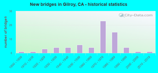
- New bridges - historical statistics
- 11900-1909
- 11910-1919
- 31920-1929
- 41930-1939
- 41940-1949
- 61950-1959
- 41960-1969
- 231970-1979
- 151980-1989
- 41990-1999
- 12000-2009
- 12010-2019
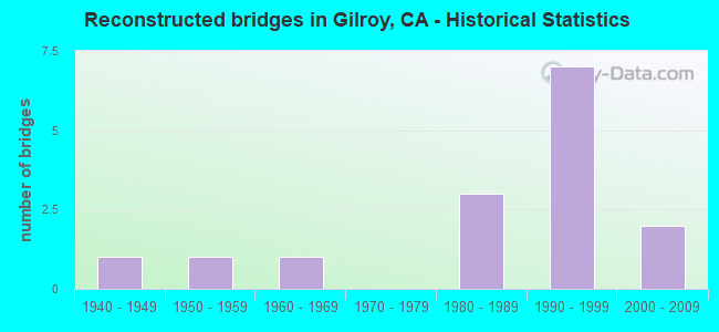
- Reconstructed bridges - Historical Statistics
- 11940-1949
- 11950-1959
- 11960-1969
- 01970-1979
- 31980-1989
- 71990-1999
- 22000-2009
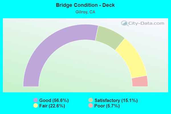
- Bridge Condition - Deck
- 56.6%Good
- 15.1%Satisfactory
- 22.6%Fair
- 5.7%Poor
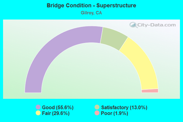
- Bridge Condition - Superstructure
- 55.6%Good
- 13.0%Satisfactory
- 29.6%Fair
- 1.9%Poor
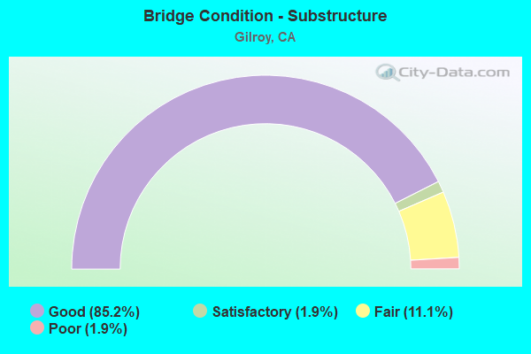
- Bridge Condition - Substructure
- 85.2%Good
- 1.9%Satisfactory
- 11.1%Fair
- 1.9%Poor
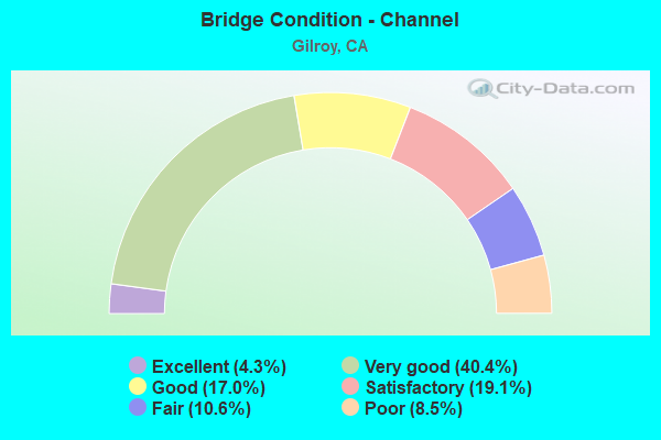
- Bridge Condition - Channel
- 4.3%Excellent
- 40.4%Very good
- 17.0%Good
- 19.1%Satisfactory
- 10.6%Fair
- 8.5%Poor
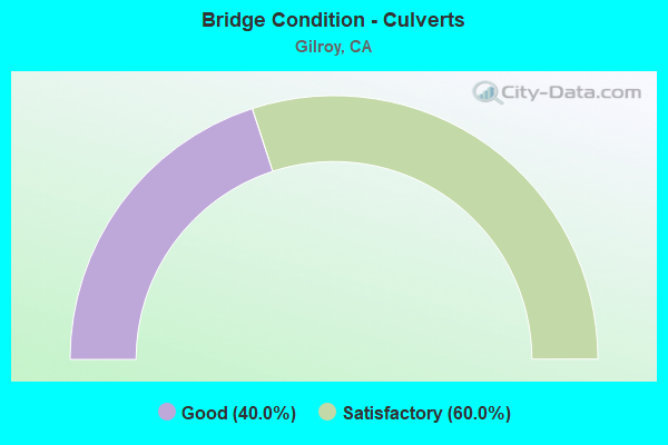
- Bridge Condition - Culverts
- 40.0%Good
- 60.0%Satisfactory
Find on map >> Show street view
Structure Number: 37C034, Location: 0.1 MI S BENTON ST (Lat: 37.344131, Lng: -121.995536), Route carried "on" structure: County highway , Year Built: 1965, Year Reconstructed: 1990, Status: Open, Structure Length: 1.11m (3.64ft), Average Daily Traffic: 74,520 (year 2014), Truck Traffic: 5%, Average Future Daily Traffic: 79,926 (year 2042), Features Intersected: CALABAZAS CREEK, Facility Carried by Structure: LAWRENCE EXPWAY
Minimum Vertical Clearance: 30+ m (98+ ft), Kilometerpoint: 0.000, Lanes on structure: 8, Base Highway Network: Yes, Owner: County Highway Agency, Approaching Roadway Width: 30.2m (99.1ft), Skew: 22 degrees, Material/Design: Concrete continuous, Design/Construction: Culvert, Number Of Spans In Main Unit: 4, Length of Maximum Span: 2.7m (8.9ft), Curb or Sidewalk Widths: Left: 1.4m (4.6ft), Right: 1.4m (4.6ft), Curb-To-Curb Width: 34.4m (112.9ft), Out-to-Out Width: 46.3m (151.9ft)
Condition: Channel: Good, Culverts: Satisfactory, Operating Rating: 40.5 metric tons, Method Used To Determine Operating Rating: Field evaluation and documented engineering judgment, Inventory Rating: 24.3 metric tons, Method Used To Determine Inventory Rating: Field evaluation and documented engineering judgment, Structural Evaluation: Equal to present minimum criteria, Deck Geometry: Better than present minimum criteria, Waterway Adequacy: Better than present minimum criteria, Approach Roadway Alignment: Better than present minimum criteria, Designated Inspection Frequency: Every 24 months, Inspection Date: October 2020
Find on map >> Show street view
Structure Number: 37C0349, Location: N/O 6TH ST (Lat: 37.008989, Lng: -121.562017), Route carried "on" structure: City street , Year Built: 1982, Status: Open, Structure Length: 1.48m (4.86ft), Average Daily Traffic: 1,041 (year 2012), Truck Traffic: 3%, Average Future Daily Traffic: 2,010 (year 2037), Features Intersected: MILLER SLOUGH, Facility Carried by Structure: ROGERS LANE
Minimum Vertical Clearance: 30+ m (98+ ft), Kilometerpoint: 0.000, Lanes on structure: 2, Owner: City or Municipal Highway Agency, Approaching Roadway Width: 7.3m (24.0ft), Material/Design: Steel, Design/Construction: Stringer/Multi-beam, Number Of Spans In Main Unit: 1, Length of Maximum Span: 13.9m (45.6ft), Curb or Sidewalk Widths: Left: 0.0m, Right: 1.2m (3.9ft), Curb-To-Curb Width: 7.3m (24.0ft), Out-to-Out Width: 9.1m (29.9ft)
Condition: Deck: Good, Superstructure: Fair, Substructure: Good, Channel: Poor, Operating Rating: 48.9 metric tons, Method Used To Determine Operating Rating: Load and Resistance Factor Rating (LRFR) rating reported by rating factor(RF) method using HL-93 loadings, Inventory Rating: 37.9 metric tons, Method Used To Determine Inventory Rating: Load and Resistance Factor Rating (LRFR) rating reported by rating factor(RF) method using HL-93 loadings, Structural Evaluation: Somewhat better than minimum adequacy, Deck Geometry: Meets minimum limits, Waterway Adequacy: Equal to present minimum criteria, Approach Roadway Alignment: Equal to present desirable criteria, Designated Inspection Frequency: Every 24 months, Other Special Inspection Frequency: Every 48 months, Inspection Date: December 2020, Other Special Inspection Date: November 2018, Deck Structure Type: Concrete Cast-file-Place, Wearing Surface/Protective System: Wearing Surface: Bituminous
Find on map >> Show street view
Structure Number: 37C0351, Location: 1 MI W MONTEREY HWY (Lat: 37.037336, Lng: -121.588511), Route carried "on" structure: County highway , Year Built: 1988, Status: Open, Structure Length: 3.43m (11.25ft), Average Daily Traffic: 4,990 (year 2011), Truck Traffic: 5%, Average Future Daily Traffic: 6,662 (year 2042), Design Load: HS 20+Mod, Features Intersected: WEST BRANCH LLAGAS CREEK, Facility Carried by Structure: DAY ROAD
Minimum Vertical Clearance: 30+ m (98+ ft), Kilometerpoint: 0.000, Lanes on structure: 2, Owner: County Highway Agency, Approaching Roadway Width: 10.4m (34.1ft), Material/Design: Concrete continuous, Design/Construction: Slab, Number Of Spans In Main Unit: 3, Length of Maximum Span: 12.1m (39.7ft), Curb-To-Curb Width: 10.4m (34.1ft), Out-to-Out Width: 11.0m (36.1ft)
Condition: Deck: Good, Superstructure: Good, Substructure: Good, Channel: Very good, Operating Rating: 54.1 metric tons, Method Used To Determine Operating Rating: Assigned rating based on Load Factor Design (LFD) reported in metric tons, Inventory Rating: 32.4 metric tons, Method Used To Determine Inventory Rating: Assigned rating based on Load Factor Design (LFD) reported in metric tons, Structural Evaluation: Better than present minimum criteria, Deck Geometry: Somewhat better than minimum adequacy, Waterway Adequacy: Equal to present desirable criteria, Approach Roadway Alignment: Equal to present desirable criteria, Designated Inspection Frequency: Every 48 months, Inspection Date: November 2020, Deck Structure Type: Concrete Cast-file-Place
Find on map >> Show street view
Structure Number: 37C0352, Location: 0.2 MI W MONTEREY RD (Lat: 37.030456, Lng: -121.584836), Route carried "on" structure: City street , Year Built: 1989, Year Reconstructed: 2006, Status: Open, Structure Length: 3.44m (11.29ft), Average Daily Traffic: 3,184 (year 2012), Truck Traffic: 4%, Average Future Daily Traffic: 6,100 (year 2037), Features Intersected: WEST BRANCH LLAGAS CREEK, Facility Carried by Structure: FARRELL AVE
Minimum Vertical Clearance: 30+ m (98+ ft), Kilometerpoint: 0.000, Lanes on structure: 3, Owner: City or Municipal Highway Agency, Approaching Roadway Width: 13.7m (44.9ft), Skew: 2 degrees, Material/Design: Concrete continuous, Design/Construction: Slab, Number Of Spans In Main Unit: 3, Length of Maximum Span: 12.2m (40.0ft), Curb or Sidewalk Widths: Left: 1.8m (5.9ft), Right: 1.8m (5.9ft), Curb-To-Curb Width: 13.7m (44.9ft), Out-to-Out Width: 18.0m (59.1ft)
Condition: Deck: Satisfactory, Superstructure: Satisfactory, Substructure: Good, Channel: Very good, Operating Rating: 25.3 metric tons, Method Used To Determine Operating Rating: Field evaluation and documented engineering judgment, Inventory Rating: 15.2 metric tons, Method Used To Determine Inventory Rating: Field evaluation and documented engineering judgment, Structural Evaluation: Meets minimum limits, Deck Geometry: Somewhat better than minimum adequacy, Waterway Adequacy: Better than present minimum criteria, Approach Roadway Alignment: Equal to present desirable criteria, Designated Inspection Frequency: Every 24 months, Inspection Date: December 2020, Deck Structure Type: Concrete Cast-file-Place
Find on map >> Show street view
Structure Number: 37C0353, Location: NW STATE ROUTE 88 (Lat: 37.027700, Lng: -121.586642), Route carried "on" structure: City street , Year Built: 1989, Status: Open, Structure Length: 2.26m (7.41ft), Average Daily Traffic: 5,000 (year 2012), Truck Traffic: 4%, Average Future Daily Traffic: 6,000 (year 2037), Design Load: HS 20+Mod, Features Intersected: LIONS CREEK, Facility Carried by Structure: WREN AVE
Minimum Vertical Clearance: 30+ m (98+ ft), Kilometerpoint: 0.000, Lanes on structure: 3, Owner: City or Municipal Highway Agency, Approaching Roadway Width: 13.4m (44.0ft), Skew: 1 degrees, Material/Design: Concrete continuous, Design/Construction: Slab, Number Of Spans In Main Unit: 2, Length of Maximum Span: 11.0m (36.1ft), Curb or Sidewalk Widths: Left: 1.2m (3.9ft), Right: 1.2m (3.9ft), Curb-To-Curb Width: 19.2m (63.0ft), Out-to-Out Width: 22.3m (73.2ft)
Condition: Deck: Fair, Superstructure: Fair, Substructure: Good, Channel: Very good, Operating Rating: 54.1 metric tons, Method Used To Determine Operating Rating: Assigned rating based on Load Factor Design (LFD) reported in metric tons, Inventory Rating: 32.4 metric tons, Method Used To Determine Inventory Rating: Assigned rating based on Load Factor Design (LFD) reported in metric tons, Structural Evaluation: Somewhat better than minimum adequacy, Deck Geometry: Superior to present desirable criteria, Waterway Adequacy: Better than present minimum criteria, Approach Roadway Alignment: Equal to present desirable criteria, Designated Inspection Frequency: Every 24 months, Inspection Date: December 2020, Deck Structure Type: Concrete Cast-file-Place
Find on map >> Show street view
Structure Number: 37C0354, Location: JUST N/O TATUM AVE (Lat: 37.027828, Lng: -121.591494), Route carried "on" structure: County highway , Year Built: 1989, Status: Open, Structure Length: 2.22m (7.28ft), Average Daily Traffic: 700 (year 2010), Truck Traffic: 5%, Average Future Daily Traffic: 1,027 (year 2042), Design Load: HS 20+Mod, Features Intersected: LIONS CREEK, Facility Carried by Structure: KERN AVE
Minimum Vertical Clearance: 30+ m (98+ ft), Kilometerpoint: 0.000, Lanes on structure: 2, Owner: County Highway Agency, Approaching Roadway Width: 9.1m (29.9ft), Material/Design: Concrete continuous, Design/Construction: Slab, Number Of Spans In Main Unit: 2, Length of Maximum Span: 10.7m (35.1ft), Curb or Sidewalk Widths: Left: 1.5m (4.9ft), Right: 1.5m (4.9ft), Curb-To-Curb Width: 11.7m (38.4ft), Out-to-Out Width: 18.3m (60.0ft)
Condition: Deck: Good, Superstructure: Good, Substructure: Good, Channel: Very good, Operating Rating: 54.1 metric tons, Method Used To Determine Operating Rating: Assigned rating based on Load Factor Design (LFD) reported in metric tons, Inventory Rating: 32.4 metric tons, Method Used To Determine Inventory Rating: Assigned rating based on Load Factor Design (LFD) reported in metric tons, Structural Evaluation: Better than present minimum criteria, Deck Geometry: Better than present minimum criteria, Waterway Adequacy: Equal to present desirable criteria, Approach Roadway Alignment: Equal to present desirable criteria, Designated Inspection Frequency: Every 48 months, Inspection Date: November 2020, Deck Structure Type: Concrete Cast-file-Place
Find on map >> Show street view
Structure Number: 37C0355, Location: JUST S/O DAY ROAD (Lat: 37.035269, Lng: -121.597261), Route carried "on" structure: County highway , Year Built: 1988, Status: Open, Structure Length: 0.76m (2.49ft), Average Daily Traffic: 7,780 (year 2014), Truck Traffic: 5%, Average Future Daily Traffic: 21,361 (year 2042), Features Intersected: LIONS CREEK, Facility Carried by Structure: SANTA TERESA BLVD
Minimum Vertical Clearance: 30+ m (98+ ft), Kilometerpoint: 0.000, Lanes on structure: 2, Owner: County Highway Agency, Approaching Roadway Width: 15.2m (49.9ft), Skew: 9 degrees, Material/Design: Concrete continuous, Design/Construction: Culvert, Number Of Spans In Main Unit: 2, Length of Maximum Span: 3.1m (10.2ft)
Condition: Channel: Very good, Culverts: Satisfactory, Operating Rating: 54.1 metric tons, Method Used To Determine Operating Rating: Field evaluation and documented engineering judgment, Inventory Rating: 32.4 metric tons, Method Used To Determine Inventory Rating: Field evaluation and documented engineering judgment, Structural Evaluation: Equal to present minimum criteria, Waterway Adequacy: Equal to present desirable criteria, Approach Roadway Alignment: Equal to present desirable criteria, Designated Inspection Frequency: Every 48 months, Inspection Date: November 2020
Find on map >> Show street view
Structure Number: 37C0363, Location: 0.2 MI N RONAN AVE (Lat: 37.027622, Lng: -121.581817), Route carried "on" structure: City street , Year Built: 1987, Status: Open, Structure Length: 3.00m (9.84ft), Average Daily Traffic: 3,800 (year 2012), Truck Traffic: 4%, Average Future Daily Traffic: 4,352 (year 2037), Design Load: HS 20+Mod, Features Intersected: W BRANCH LLAGAS CREEK, Facility Carried by Structure: CHURCH ST
Minimum Vertical Clearance: 30+ m (98+ ft), Kilometerpoint: 0.000, Lanes on structure: 2, Owner: City or Municipal Highway Agency, Approaching Roadway Width: 16.8m (55.1ft), Material/Design: Concrete continuous, Design/Construction: Slab, Number Of Spans In Main Unit: 3, Length of Maximum Span: 11.3m (37.1ft), Curb or Sidewalk Widths: Left: 1.7m (5.6ft), Right: 1.7m (5.6ft), Curb-To-Curb Width: 16.2m (53.1ft), Out-to-Out Width: 20.1m (65.9ft)
Condition: Deck: Good, Superstructure: Good, Substructure: Good, Channel: Very good, Operating Rating: 54.1 metric tons, Method Used To Determine Operating Rating: Assigned rating based on Load Factor Design (LFD) reported in metric tons, Inventory Rating: 32.4 metric tons, Method Used To Determine Inventory Rating: Assigned rating based on Load Factor Design (LFD) reported in metric tons, Structural Evaluation: Better than present minimum criteria, Deck Geometry: Superior to present desirable criteria, Waterway Adequacy: Equal to present desirable criteria, Approach Roadway Alignment: Better than present minimum criteria, Designated Inspection Frequency: Every 48 months, Inspection Date: December 2020, Deck Structure Type: Concrete Cast-file-Place
Find on map >> Show street view
Structure Number: 37C042, Location: IN SHORELINE PARK (Lat: 37.431697, Lng: -122.086756), Route carried "on" structure: City street , Year Built: 1982, Status: Open, Structure Length: 1.61m (5.28ft), Average Daily Traffic: 2,000 (year 2013), Truck Traffic: 5%, Average Future Daily Traffic: 2,252 (year 2042), Features Intersected: PERMANENTE CREEK, Facility Carried by Structure: SHORELINE BLVD
Minimum Vertical Clearance: 30+ m (98+ ft), Kilometerpoint: 0.000, Lanes on structure: 2, Owner: City or Municipal Highway Agency, Approaching Roadway Width: 9.1m (29.9ft), Material/Design: Steel, Design/Construction: Culvert, Number Of Spans In Main Unit: 2, Length of Maximum Span: 7.9m (25.9ft), Curb-To-Curb Width: 9.1m (29.9ft), Out-to-Out Width: 9.8m (32.2ft)
Condition: Channel: Satisfactory, Culverts: Satisfactory, Operating Rating: 54.1 metric tons, Method Used To Determine Operating Rating: Field evaluation and documented engineering judgment, Inventory Rating: 32.4 metric tons, Method Used To Determine Inventory Rating: Field evaluation and documented engineering judgment, Structural Evaluation: Equal to present minimum criteria, Deck Geometry: Somewhat better than minimum adequacy, Waterway Adequacy: Equal to present minimum criteria, Approach Roadway Alignment: Equal to present desirable criteria, Designated Inspection Frequency: Every 24 months, Inspection Date: January 2022
Find on map >> Show street view
Structure Number: 37C0427, Location: 500 FT SOUTH OF GILMAN RD (Lat: 37.009461, Lng: -121.554886), Route carried "on" structure: City street , Year Built: 2009, Status: Open, Structure Length: 4.60m (15.09ft), Average Daily Traffic: 25,100 (year 2012), Truck Traffic: 5%, Average Future Daily Traffic: 31,836 (year 2042), Design Load: HS 20+Mod, Features Intersected: WEST BRANCH LLAGAS CREEK, Facility Carried by Structure: CAMINO ARROYO ST
Minimum Vertical Clearance: 30+ m (98+ ft), Kilometerpoint: 0.000, Lanes on structure: 4, Base Highway Network: Yes, Owner: City or Municipal Highway Agency, Approaching Roadway Width: 18.9m (62.0ft), Skew: 33 degrees, Material/Design: Prestressed concrete continuous, Design/Construction: Box Beam or Girders - Multiple, Number Of Spans In Main Unit: 2, Length of Maximum Span: 22.6m (74.1ft), Curb or Sidewalk Widths: Left: 2.1m (6.9ft), Right: 2.1m (6.9ft), Curb-To-Curb Width: 18.9m (62.0ft), Out-to-Out Width: 26.8m (87.9ft)
Condition: Deck: Good, Superstructure: Good, Substructure: Good, Channel: Very good, Operating Rating: 54.1 metric tons, Method Used To Determine Operating Rating: Assigned rating based on Load Factor Design (LFD) reported in metric tons, Inventory Rating: 32.4 metric tons, Method Used To Determine Inventory Rating: Assigned rating based on Load Factor Design (LFD) reported in metric tons, Structural Evaluation: Better than present minimum criteria, Deck Geometry: Equal to present minimum criteria, Waterway Adequacy: Superior to present desirable criteria, Approach Roadway Alignment: Equal to present desirable criteria, Designated Inspection Frequency: Every 48 months, Inspection Date: December 2020, Deck Structure Type: Concrete Cast-file-Place
Find on map >> Show street view
Structure Number: 37C0534, Location: BLOOMFIELD AVE (Lat: 36.978372, Lng: -121.508542), Route carried "on" structure: County highway , Year Built: 1927, Year Reconstructed: 2001, Status: Open, Structure Length: 0.91m (2.99ft), Average Daily Traffic: 3,800 (year 2014), Truck Traffic: 15%, Average Future Daily Traffic: 5,323 (year 2040), Features Intersected: FURLONG CREEK, Facility Carried by Structure: FRAZIER LAKE RD
Minimum Vertical Clearance: 30+ m (98+ ft), Kilometerpoint: 0.000, Lanes on structure: 2, Owner: County Highway Agency, Approaching Roadway Width: 11.0m (36.1ft), Material/Design: Concrete continuous, Design/Construction: Slab, Number Of Spans In Main Unit: 2, Length of Maximum Span: 4.3m (14.1ft), Curb-To-Curb Width: 9.8m (32.2ft), Out-to-Out Width: 10.9m (35.8ft)
Condition: Deck: Good, Superstructure: Good, Substructure: Good, Channel: Poor, Operating Rating: 26.9 metric tons, Method Used To Determine Operating Rating: Field evaluation and documented engineering judgment, Inventory Rating: 16.2 metric tons, Method Used To Determine Inventory Rating: Field evaluation and documented engineering judgment, Structural Evaluation: Meets minimum limits, Deck Geometry: Meets minimum limits, Waterway Adequacy: Better than present minimum criteria, Approach Roadway Alignment: Superior to present desirable criteria, Designated Inspection Frequency: Every 24 months, Inspection Date: November 2020, Deck Structure Type: Concrete Cast-file-Place, Wearing Surface/Protective System: Wearing Surface: Bituminous
Find on map >> Show street view
Structure Number: 37C0535, Location: 0.4 MI S/E BLOOMFIELD AVE (Lat: 36.974928, Lng: -121.504853), Route carried "on" structure: County highway , Year Built: 1927, Year Reconstructed: 2004, Status: Open, Structure Length: 1.13m (3.71ft), Average Daily Traffic: 3,800 (year 2014), Truck Traffic: 10%, Average Future Daily Traffic: 5,101 (year 2040), Features Intersected: BRANCH OF PAJARO RIVER, Facility Carried by Structure: FRAZIER LAKE ROAD
Minimum Vertical Clearance: 30+ m (98+ ft), Kilometerpoint: 0.000, Lanes on structure: 2, Owner: County Highway Agency, Approaching Roadway Width: 8.0m (26.2ft), Skew: 2 degrees, Material/Design: Concrete continuous, Design/Construction: Slab, Number Of Spans In Main Unit: 2, Length of Maximum Span: 5.5m (18.0ft), Curb-To-Curb Width: 7.8m (25.6ft), Out-to-Out Width: 7.9m (25.9ft)
Condition: Deck: Fair, Superstructure: Fair, Substructure: Good, Channel: Satisfactory, Operating Rating: 27.5 metric tons, Method Used To Determine Operating Rating: Field evaluation and documented engineering judgment, Inventory Rating: 16.5 metric tons, Method Used To Determine Inventory Rating: Field evaluation and documented engineering judgment, Structural Evaluation: Meets minimum limits, Deck Geometry: High priority of replacement, Waterway Adequacy: Equal to present minimum criteria, Approach Roadway Alignment: Superior to present desirable criteria, Designated Inspection Frequency: Every 24 months, Inspection Date: November 2020, Deck Structure Type: Concrete Cast-file-Place, Wearing Surface/Protective System: Wearing Surface: Bituminous
Find on map >> Show street view
Structure Number: 37C0536, Location: 0.6 MI S/E BLOOMFIELD AVE (Lat: 36.972064, Lng: -121.501611), Route carried "on" structure: County highway , Year Built: 1927, Year Reconstructed: 2004, Status: Open, Structure Length: 1.37m (4.49ft), Average Daily Traffic: 3,800 (year 2014), Truck Traffic: 5%, Average Future Daily Traffic: 5,101 (year 2040), Features Intersected: PAJARO RIVER, Facility Carried by Structure: FRAZIER LAKE ROAD
Minimum Vertical Clearance: 30+ m (98+ ft), Kilometerpoint: 0.000, Lanes on structure: 2, Owner: County Highway Agency, Approaching Roadway Width: 8.3m (27.2ft), Skew: 2 degrees, Material/Design: Concrete continuous, Design/Construction: Slab, Number Of Spans In Main Unit: 2, Length of Maximum Span: 6.7m (22.0ft), Curb-To-Curb Width: 8.2m (26.9ft), Out-to-Out Width: 8.5m (27.9ft)
Condition: Deck: Fair, Superstructure: Fair, Substructure: Good, Channel: Fair, Operating Rating: 28.5 metric tons, Method Used To Determine Operating Rating: Field evaluation and documented engineering judgment, Inventory Rating: 17.2 metric tons, Method Used To Determine Inventory Rating: Field evaluation and documented engineering judgment, Structural Evaluation: Meets minimum limits, Deck Geometry: High priority of corrective action, Waterway Adequacy: Better than present minimum criteria, Approach Roadway Alignment: Equal to present desirable criteria, Designated Inspection Frequency: Every 24 months, Inspection Date: November 2020, Deck Structure Type: Concrete Cast-file-Place, Wearing Surface/Protective System: Wearing Surface: Bituminous
Find on map >> Show street view
Structure Number: 37C0537, Location: HOLSCLAW ROAD (Lat: 37.016958, Lng: -121.543403), Route carried "on" structure: County highway , Year Built: 1987, Status: Open, Structure Length: 4.77m (15.65ft), Average Daily Traffic: 1,570 (year 2014), Truck Traffic: 5%, Average Future Daily Traffic: 1,566 (year 2042), Design Load: HS 20+Mod, Features Intersected: LLAGAS CREEK, Facility Carried by Structure: GILMAN ROAD
Minimum Vertical Clearance: 3.66m (12.01ft), Kilometerpoint: 0.000, Lanes on structure: 2, Owner: County Highway Agency, Approaching Roadway Width: 7.5m (24.6ft), Skew: 1 degrees, Material/Design: Concrete continuous, Design/Construction: Slab, Number Of Spans In Main Unit: 4, Length of Maximum Span: 11.7m (38.4ft), Curb-To-Curb Width: 11.0m (36.1ft), Out-to-Out Width: 12.0m (39.4ft)
Condition: Deck: Good, Superstructure: Good, Substructure: Good, Channel: Very good, Operating Rating: 54.1 metric tons, Method Used To Determine Operating Rating: Assigned rating based on Load Factor Design (LFD) reported in metric tons, Inventory Rating: 32.4 metric tons, Method Used To Determine Inventory Rating: Assigned rating based on Load Factor Design (LFD) reported in metric tons, Structural Evaluation: Better than present minimum criteria, Deck Geometry: Equal to present minimum criteria, Waterway Adequacy: Equal to present desirable criteria, Approach Roadway Alignment: High priority of corrective action, Designated Inspection Frequency: Every 48 months, Inspection Date: November 2020, Deck Structure Type: Concrete Cast-file-Place
Find on map >> Show street view
Structure Number: 37C0562, Location: 0.3 MI W WATSONVILLE RD (Lat: 37.028028, Lng: -121.659275), Route carried "on" structure: County highway , Year Built: 1909, Status: Open, Structure Length: 0.95m (3.12ft), Average Daily Traffic: 400 (year 2011), Truck Traffic: 5%, Average Future Daily Traffic: 612 (year 2037), Features Intersected: LITTLE ARTHUR CREEK, Facility Carried by Structure: REDWOOD RETREAT RD
Minimum Vertical Clearance: 4.57m (14.99ft), Kilometerpoint: 0.000, Lanes on structure: 2, Owner: County Highway Agency, Approaching Roadway Width: 5.7m (18.7ft), Material/Design: Concrete, Design/Construction: Arch - Deck, Number Of Spans In Main Unit: 1, Length of Maximum Span: 7.3m (24.0ft), Curb-To-Curb Width: 5.5m (18.0ft), Out-to-Out Width: 5.7m (18.7ft)
Condition: Superstructure: Fair, Substructure: Fair, Channel: Satisfactory, Operating Rating: 27.2 metric tons, Method Used To Determine Operating Rating: Field evaluation and documented engineering judgment, Inventory Rating: 16.2 metric tons, Method Used To Determine Inventory Rating: Field evaluation and documented engineering judgment, Structural Evaluation: Somewhat better than minimum adequacy, Deck Geometry: High priority of corrective action, Waterway Adequacy: Meets minimum limits, Approach Roadway Alignment: Equal to present desirable criteria, Designated Inspection Frequency: Every 24 months, Inspection Date: September 2020
Find on map >> Show street view
Structure Number: 37C058, Location: 0.6 MI W MONTEREY RD (Lat: 36.991572, Lng: -121.572692), Route carried "on" structure: County highway , Year Built: 1989, Status: Open, Structure Length: 8.09m (26.54ft), Average Daily Traffic: 6,920 (year 2014), Truck Traffic: 5%, Average Future Daily Traffic: 9,239 (year 2042), Design Load: HS 20, Features Intersected: CARNADERO CREEK (UVAS), Facility Carried by Structure: THOMAS/LUCHESSA RD
Minimum Vertical Clearance: 30+ m (98+ ft), Kilometerpoint: 0.000, Lanes on structure: 2, Owner: County Highway Agency, Approaching Roadway Width: 7.3m (24.0ft), Skew: 1 degrees, Material/Design: Concrete continuous, Design/Construction: Box Beam or Girders - Multiple, Number Of Spans In Main Unit: 3, Length of Maximum Span: 26.8m (87.9ft), Curb-To-Curb Width: 10.9m (35.8ft), Out-to-Out Width: 11.1m (36.4ft)
Condition: Deck: Good, Superstructure: Good, Substructure: Good, Channel: Very good, Operating Rating: 54.1 metric tons, Method Used To Determine Operating Rating: Field evaluation and documented engineering judgment, Inventory Rating: 32.4 metric tons, Method Used To Determine Inventory Rating: Field evaluation and documented engineering judgment, Structural Evaluation: Better than present minimum criteria, Deck Geometry: Meets minimum limits, Waterway Adequacy: Equal to present desirable criteria, Approach Roadway Alignment: Equal to present desirable criteria, Designated Inspection Frequency: Every 48 months, Inspection Date: November 2020, Deck Structure Type: Concrete Cast-file-Place
Find on map >> Show street view
Structure Number: 37C0582, Location: 1.86 M S/O HECKER PASS RD (Lat: 36.985378, Lng: -121.657300), Route carried "on" structure: County highway , Year Built: 1939, Status: Open, Structure Length: 1.49m (4.89ft), Average Daily Traffic: 70 (year 2011), Truck Traffic: 2%, Average Future Daily Traffic: 84 (year 2037), Features Intersected: BODFISH CREEK, Facility Carried by Structure: WHITEHURST ROAD
Minimum Vertical Clearance: 30+ m (98+ ft), Kilometerpoint: 0.000, Lanes on structure: 2, Owner: County Highway Agency, Approaching Roadway Width: 5.5m (18.0ft), Material/Design: Concrete, Design/Construction: Tee Beam, Number Of Spans In Main Unit: 1, Length of Maximum Span: 14.3m (46.9ft), Curb-To-Curb Width: 6.1m (20.0ft), Out-to-Out Width: 7.0m (23.0ft)
Condition: Deck: Good, Superstructure: Fair, Substructure: Good, Channel: Good, Operating Rating: 31.4 metric tons, Method Used To Determine Operating Rating: Load Factor (LF), Inventory Rating: 19.1 metric tons, Method Used To Determine Inventory Rating: Load Factor (LF), Structural Evaluation: Somewhat better than minimum adequacy, Deck Geometry: Somewhat better than minimum adequacy, Waterway Adequacy: Meets minimum limits, Approach Roadway Alignment: Equal to present minimum criteria, Designated Inspection Frequency: Every 24 months, Inspection Date: September 2020, Deck Structure Type: Concrete Cast-file-Place, Wearing Surface/Protective System: Wearing Surface: Bituminous
Find on map >> Show street view
Structure Number: 37C0583, Location: 0.16 MI S/O HECKER PASS R (Lat: 37.004081, Lng: -121.667317), Route carried "on" structure: County highway , Year Built: 1939, Status: Open, Structure Length: 1.10m (3.61ft), Average Daily Traffic: 70 (year 2011), Truck Traffic: 2%, Average Future Daily Traffic: 204 (year 2037), Features Intersected: BODFISH CREEK, Facility Carried by Structure: WHITEHURST ROAD
Minimum Vertical Clearance: 30+ m (98+ ft), Kilometerpoint: 0.000, Lanes on structure: 2, Owner: County Highway Agency, Approaching Roadway Width: 5.5m (18.0ft), Skew: 3 degrees, Material/Design: Concrete, Design/Construction: Tee Beam, Number Of Spans In Main Unit: 1, Length of Maximum Span: 10.4m (34.1ft), Curb-To-Curb Width: 6.1m (20.0ft), Out-to-Out Width: 7.0m (23.0ft)
Condition: Deck: Good, Superstructure: Good, Substructure: Satisfactory, Channel: Satisfactory, Operating Rating: 25.9 metric tons, Method Used To Determine Operating Rating: Field evaluation and documented engineering judgment, Inventory Rating: 15.6 metric tons, Method Used To Determine Inventory Rating: Field evaluation and documented engineering judgment, Structural Evaluation: Meets minimum limits, Deck Geometry: Somewhat better than minimum adequacy, Waterway Adequacy: Somewhat better than minimum adequacy, Approach Roadway Alignment: Equal to present minimum criteria, Designated Inspection Frequency: Every 24 months, Inspection Date: September 2020, Deck Structure Type: Concrete Cast-file-Place, Wearing Surface/Protective System: Wearing Surface: Bituminous
Find on map >> Show street view
Structure Number: 43 0001, Location: 05-SBT-025-60.04 (Lat: 36.947997, Lng: -121.511772), Route carried "on" structure: State highway 25, Year Built: 1951, Year Reconstructed: 1991, Status: Open, Structure Length: 6.46m (21.19ft), Average Daily Traffic: 18,000 (year 2009), Truck Traffic: 10%, Average Future Daily Traffic: 33,953 (year 2042), Design Load: HS 20, Features Intersected: PAJARO RIVER
Minimum Vertical Clearance: 30+ m (98+ ft), Kilometerpoint: 60.040, Lanes on structure: 2, Base Highway Network: Yes (, Subroute: 1), Owner: State Highway Agency, Approaching Roadway Width: 12.2m (40.0ft), Material/Design: Concrete continuous, Design/Construction: Slab, Number Of Spans In Main Unit: 6, Length of Maximum Span: 11.6m (38.1ft), Curb-To-Curb Width: 12.2m (40.0ft), Out-to-Out Width: 13.3m (43.6ft)
Condition: Deck: Good, Superstructure: Good, Substructure: Poor, Channel: Fair, Operating Rating: 54.1 metric tons, Method Used To Determine Operating Rating: Assigned rating based on Load Factor Design (LFD) reported in metric tons, Inventory Rating: 32.4 metric tons, Method Used To Determine Inventory Rating: Assigned rating based on Load Factor Design (LFD) reported in metric tons, Structural Evaluation: Meets minimum limits, Deck Geometry: Somewhat better than minimum adequacy, Waterway Adequacy: Superior to present desirable criteria, Approach Roadway Alignment: Equal to present desirable criteria, Length Of Structure Improvement: 6.46m (21.19ft), Designated Inspection Frequency: Every 24 months, Inspection Date: June 2020, Bridge Improvement Cost: $857,000, Roadway Improvement Cost: $171,000, Total Project Cost: $1,439,000 ( Estimate for 2021), Deck Structure Type: Concrete Cast-file-Place, Wearing Surface/Protective System: Wearing Surface: Integral Concrete
Find on map >> Show street view
Structure Number: 43C0033, Location: 1.2 MILE N OF SHORE ROAD (Lat: 36.963422, Lng: -121.491836), Route carried "on" structure: County highway , Year Built: 1995, Status: Open, Structure Length: 2.18m (7.15ft), Average Daily Traffic: 4,880 (year 2010), Truck Traffic: 5%, Average Future Daily Traffic: 5,516 (year 2041), Design Load: HS 20+Mod, Features Intersected: MILLERS CANAL, Facility Carried by Structure: FRAZIER LAKE ROAD
Minimum Vertical Clearance: 30+ m (98+ ft), Kilometerpoint: 0.000, Lanes on structure: 2, Owner: County Highway Agency, Approaching Roadway Width: 10.0m (32.8ft), Skew: 1 degrees, Material/Design: Concrete continuous, Design/Construction: Slab, Number Of Spans In Main Unit: 3, Length of Maximum Span: 8.6m (28.2ft), Curb-To-Curb Width: 9.7m (31.8ft), Out-to-Out Width: 9.9m (32.5ft)
Condition: Deck: Fair, Superstructure: Fair, Substructure: Good, Channel: Very good, Operating Rating: 54.1 metric tons, Method Used To Determine Operating Rating: Assigned rating based on Load Factor Design (LFD) reported in metric tons, Inventory Rating: 32.4 metric tons, Method Used To Determine Inventory Rating: Assigned rating based on Load Factor Design (LFD) reported in metric tons, Structural Evaluation: Somewhat better than minimum adequacy, Deck Geometry: Meets minimum limits, Waterway Adequacy: Equal to present desirable criteria, Approach Roadway Alignment: Equal to present desirable criteria, Designated Inspection Frequency: Every 24 months, Inspection Date: January 2021, Deck Structure Type: Concrete Cast-file-Place
Find on map >> Show street view
Structure Number: 37 0304L, Location: 04-SCL-101-R4.94 (Lat: 36.986775, Lng: -121.558547), Route carried "under" structure: County highway C218, Year Built: 1973, Structure Length: 0. m, Average Daily Traffic: 5,000 (year 1998), Truck Traffic: 3%, Features Intersected: MONTEREY ROAD, Facility Carried by Structure: U.S. HWY 101 (SB)
Minimum Vertical Clearance: 5.20m (17.06ft), Kilometerpoint: 0.000, Lanes on structure: 3, Lanes under structure: 5, Material/Design: Prestressed concrete, Design/Construction: Box Beam or Girders - Multiple, Length of Maximum Span: 49.2m (161.4ft)
Find on map >> Show street view
Structure Number: 37 0304R, Location: 04-SCL-101-R4.94 (Lat: 36.986564, Lng: -121.558150), Route carried "under" structure: County highway C218, Year Built: 1973, Structure Length: 0. m, Average Daily Traffic: 5,000 (year 1998), Truck Traffic: 3%, Features Intersected: MONTEREY ROAD, Facility Carried by Structure: U.S. HWY 101 (NB)
Minimum Vertical Clearance: 4.80m (15.75ft), Kilometerpoint: 0.000, Lanes on structure: 4, Lanes under structure: 5, Material/Design: Prestressed concrete, Design/Construction: Box Beam or Girders - Multiple, Length of Maximum Span: 49.2m (161.4ft)
Find on map >> Show street view
Structure Number: 37 0325, Location: 04-SCL-152-R9.92-GIL (Lat: 37.002772, Lng: -121.556967), Route carried "under" structure: US 101, Year Built: 1972, Structure Length: 0. m, Average Daily Traffic: 52,000 (year 2009), Truck Traffic: 8%, Features Intersected: U.S. HIGHWAY 101, Facility Carried by Structure: SR 152 (10TH ST)
Minimum Vertical Clearance: 5.38m (17.65ft), Kilometerpoint: 6.080, Lanes on structure: 4, Lanes under structure: 8, Material/Design: Prestressed concrete continuous, Design/Construction: Box Beam or Girders - Multiple, Length of Maximum Span: 48.6m (159.4ft)
Find on map >> Show street view
Structure Number: 37 0326, Location: 04-SCL-101-R6.58-GIL (Lat: 37.009608, Lng: -121.560161), Route carried "under" structure: US 101, Year Built: 1972, Structure Length: 0. m, Average Daily Traffic: 52,000 (year 2009), Truck Traffic: 8%, Features Intersected: U.S. HIGHWAY 101, Facility Carried by Structure: 6TH STREET
Minimum Vertical Clearance: 5.28m (17.32ft), Kilometerpoint: 6.580, Lanes on structure: 2, Lanes under structure: 6, Material/Design: Prestressed concrete continuous, Design/Construction: Box Beam or Girders - Multiple, Length of Maximum Span: 48.5m (159.1ft)
Find on map >> Show street view
Structure Number: 37 0328L, Location: 04-SCL-101-R7.52-GIL (Lat: 37.022167, Lng: -121.566650), Route carried "under" structure: State highway 152, Year Built: 1973, Structure Length: 0. m, Average Daily Traffic: 22,550 (year 1998), Truck Traffic: 3%, Features Intersected: STATE ROUTE 152, Facility Carried by Structure: U.S. HWY 101 (SB)
Minimum Vertical Clearance: 4.87m (15.98ft), Kilometerpoint: 9.730, Lanes on structure: 3, Lanes under structure: 8, Material/Design: Prestressed concrete, Design/Construction: Box Beam or Girders - Multiple, Length of Maximum Span: 48.5m (159.1ft)
Find on map >> Show street view
Structure Number: 37 0328R, Location: 04-SCL-101-R7.52-GIL (Lat: 37.022322, Lng: -121.566236), Route carried "under" structure: State highway 152, Year Built: 1973, Structure Length: 0. m, Average Daily Traffic: 22,550 (year 1998), Truck Traffic: 3%, Features Intersected: STATE ROUTE 152, Facility Carried by Structure: U.S. HWY 101 (NB)
Minimum Vertical Clearance: 4.57m (14.99ft), Kilometerpoint: 9.730, Lanes on structure: 4, Lanes under structure: 8, Material/Design: Prestressed concrete, Design/Construction: Box Beam or Girders - Multiple, Length of Maximum Span: 48.5m (159.1ft)
Find on map >> Show street view
Structure Number: 37 0329, Location: 04-SCL-101-R9.13 (Lat: 37.043533, Lng: -121.578139), Route carried "under" structure: US 101, Year Built: 1972, Structure Length: 0. m, Average Daily Traffic: 110,000 (year 2009), Truck Traffic: 13%, Features Intersected: U.S. HIGHWAY 101, Facility Carried by Structure: BUENA VISTA AVENUE
Minimum Vertical Clearance: 5.23m (17.16ft), Kilometerpoint: 9.130, Lanes on structure: 2, Lanes under structure: 7, Material/Design: Prestressed concrete continuous, Design/Construction: Box Beam or Girders - Multiple, Length of Maximum Span: 35.1m (115.2ft)
Find on map >> Show street view
Structure Number: 37 0468, Location: 04-SCL-025-2.49 (Lat: 36.961414, Lng: -121.550606), Route carried "under" structure: US 101, Year Built: 1989, Structure Length: 0. m, Average Daily Traffic: 52,000 (year 2009), Truck Traffic: 8%, Features Intersected: U.S. HIGHWAY 101, Facility Carried by Structure: STATE ROUTE 25
Minimum Vertical Clearance: 5.03m (16.50ft), Kilometerpoint: 3.200, Lanes on structure: 2, Lanes under structure: 5, Material/Design: Prestressed concrete, Design/Construction: Stringer/Multi-beam, Length of Maximum Span: 22.6m (74.1ft)