Bridge Statistics for Gillette, Wyoming (WY)
Condition, Traffic, Stress, Structural Evaluation, Project Costs
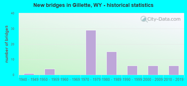
- New bridges - historical statistics
- 11940-1949
- 41950-1959
- 291970-1979
- 151980-1989
- 61990-1999
- 62000-2009
- 62010-2019
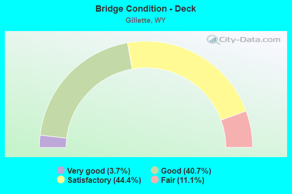
- Bridge Condition - Deck
- 3.7%Very good
- 40.7%Good
- 44.4%Satisfactory
- 11.1%Fair
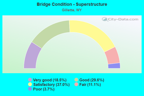
- Bridge Condition - Superstructure
- 18.5%Very good
- 29.6%Good
- 37.0%Satisfactory
- 11.1%Fair
- 3.7%Poor
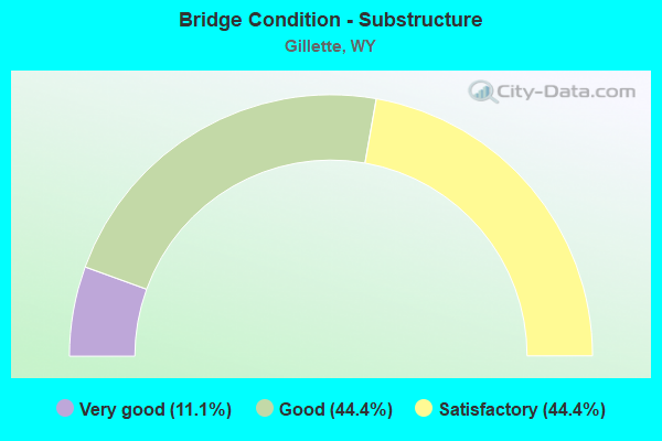
- Bridge Condition - Substructure
- 11.1%Very good
- 44.4%Good
- 44.4%Satisfactory
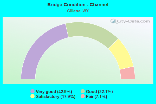
- Bridge Condition - Channel
- 42.9%Very good
- 32.1%Good
- 17.9%Satisfactory
- 7.1%Fair
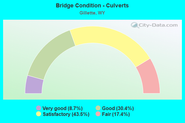
- Bridge Condition - Culverts
- 8.7%Very good
- 30.4%Good
- 43.5%Satisfactory
- 17.4%Fair
Find on map >> Show street view
Structure Number: MBF, Location: P-43 Gillette St/Douglas (Lat: 44.272097, Lng: -105.494078), Route carried "on" structure: State highway 59, Year Built: 2008, Status: Open, Structure Length: 0.80m (2.62ft), Average Daily Traffic: 21,193 (year 2021), Truck Traffic: 5%, Average Future Daily Traffic: 29,670 (year 2041), Design Load: HL 93, Features Intersected: Homestead Trickle
Minimum Vertical Clearance: 30+ m (98+ ft), Kilometerpoint: 181.072, Lanes on structure: 7, Base Highway Network: Yes (Inventory Route: ML4, Subroute: 2), Owner: State Highway Agency, Approaching Roadway Width: 33.5m (109.9ft), Material/Design: Concrete, Design/Construction: Culvert, Number Of Spans In Main Unit: 2, Length of Maximum Span: 3.7m (12.1ft)
Condition: Channel: Very good, Culverts: Good, Operating Rating: 32.7 metric tons, Method Used To Determine Operating Rating: Field evaluation and documented engineering judgment, Inventory Rating: 32.7 metric tons, Method Used To Determine Inventory Rating: Field evaluation and documented engineering judgment, Structural Evaluation: Better than present minimum criteria, Waterway Adequacy: Equal to present desirable criteria, Approach Roadway Alignment: Equal to present desirable criteria, Designated Inspection Frequency: Every 24 months, Inspection Date: July 2020
Find on map >> Show street view
Structure Number: MCO, Location: Gillette (Lat: 44.287586, Lng: -105.520972), Route carried "on" structure: City street 4626, Year Built: 2010, Status: Open, Structure Length: 8.53m (27.99ft), Average Daily Traffic: 3,980 (year 2021), Truck Traffic: 22%, Average Future Daily Traffic: 5,572 (year 2041), Design Load: HL 93, Features Intersected: I-90, Facility Carried by Structure: Oakcrest Drive
Minimum Vertical Clearance: 30+ m (98+ ft), Kilometerpoint: 160.436, Lanes on structure: 4, Lanes under structure: 4, Owner: State Highway Agency, Approaching Roadway Width: 21.6m (70.9ft), Material/Design: Steel continuous, Design/Construction: Stringer/Multi-beam, Number Of Spans In Main Unit: 3, Length of Maximum Span: 57.9m (190.0ft), Curb or Sidewalk Widths: Left: 1.5m (4.9ft), Right: 3.0m (9.8ft), Curb-To-Curb Width: 21.6m (70.9ft), Out-to-Out Width: 27.5m (90.2ft)
Condition: Deck: Good, Superstructure: Very good, Substructure: Good, Operating Rating: 50.5 metric tons, Method Used To Determine Operating Rating: Load and Resistance Factor Rating (LRFR) rating reported by rating factor(RF) method using HL-93 loadings, Inventory Rating: 38.9 metric tons, Method Used To Determine Inventory Rating: Load and Resistance Factor Rating (LRFR) rating reported by rating factor(RF) method using HL-93 loadings, Structural Evaluation: Better than present minimum criteria, Deck Geometry: Superior to present desirable criteria, Underclear: Superior to present desirable criteria, Approach Roadway Alignment: Equal to present desirable criteria, Designated Inspection Frequency: Every 24 months, Inspection Date: May 2021, Deck Structure Type: Concrete Cast-file-Place, Wearing Surface/Protective System: Deck Protection: Epoxy Coated Reinforcing
Find on map >> Show street view
Structure Number: MFI, Location: 4 Mi N Of Gillette (Lat: 44.361483, Lng: -105.523067), Route carried "on" structure: US 302, Year Built: 2009, Status: Open, Structure Length: 1.38m (4.53ft), Average Daily Traffic: 2,965 (year 2021), Truck Traffic: 11%, Average Future Daily Traffic: 4,151 (year 2041), Design Load: HS 25 or greater, Features Intersected: Little Rawhide Creek, Facility Carried by Structure: US 14
Minimum Vertical Clearance: 30+ m (98+ ft), Kilometerpoint: 162.291, Lanes on structure: 3, Owner: State Highway Agency, Approaching Roadway Width: 12.2m (40.0ft), Material/Design: Concrete, Design/Construction: Culvert, Number Of Spans In Main Unit: 4, Length of Maximum Span: 3.0m (9.8ft)
Condition: Channel: Satisfactory, Culverts: Satisfactory, Operating Rating: 66.3 metric tons, Method Used To Determine Operating Rating: Field evaluation and documented engineering judgment, Inventory Rating: 39.7 metric tons, Method Used To Determine Inventory Rating: Field evaluation and documented engineering judgment, Structural Evaluation: Equal to present minimum criteria, Waterway Adequacy: Equal to present desirable criteria, Approach Roadway Alignment: Equal to present desirable criteria, Designated Inspection Frequency: Every 24 months, Inspection Date: May 2021
Find on map >> Show street view
Structure Number: MQC, Location: Gillette, Butler Spaeth R (Lat: 44.269111, Lng: -105.483169), Route carried "on" structure: City street 4600, Year Built: 2007, Status: Open, Structure Length: 2.74m (8.99ft), Average Daily Traffic: 5,896 (year 2021), Truck Traffic: 2%, Average Future Daily Traffic: 8,254 (year 2041), Design Load: HL 93, Features Intersected: Donkey Creek, Facility Carried by Structure: Butler Spaeth Road
Minimum Vertical Clearance: 30+ m (98+ ft), Kilometerpoint: 157.993, Lanes on structure: 4, Owner: Town or Township Highway Agency, Approaching Roadway Width: 18.9m (62.0ft), Material/Design: Steel, Design/Construction: Stringer/Multi-beam, Number Of Spans In Main Unit: 1, Length of Maximum Span: 27.4m (89.9ft), Curb or Sidewalk Widths: Left: 1.8m (5.9ft), Right: 3.0m (9.8ft), Curb-To-Curb Width: 20.1m (65.9ft), Out-to-Out Width: 25.7m (84.3ft)
Condition: Deck: Good, Superstructure: Good, Substructure: Good, Channel: Good, Operating Rating: 42.1 metric tons, Method Used To Determine Operating Rating: Assigned ratings based on Load and Resistance Factor Design (LRFD) reported by rating factor (RF) using HL93 loadings, Inventory Rating: 32.4 metric tons, Method Used To Determine Inventory Rating: Assigned ratings based on Load and Resistance Factor Design (LRFD) reported by rating factor (RF) using HL93 loadings, Structural Evaluation: Better than present minimum criteria, Deck Geometry: Better than present minimum criteria, Waterway Adequacy: Equal to present desirable criteria, Approach Roadway Alignment: Equal to present desirable criteria, Designated Inspection Frequency: Every 24 months, Inspection Date: Febuary 2022, Deck Structure Type: Concrete Cast-file-Place, Wearing Surface/Protective System: Deck Protection: Epoxy Coated Reinforcing
Find on map >> Show street view
Structure Number: MQF, Location: Gillette, Shoshone Ave (Lat: 44.253756, Lng: -105.505967), Route carried "on" structure: City street 4630, Year Built: 2007, Status: Open, Structure Length: 1.09m (3.58ft), Average Daily Traffic: 3,521 (year 2021), Truck Traffic: 22%, Average Future Daily Traffic: 4,929 (year 2041), Features Intersected: Donkey Creek, Facility Carried by Structure: Shoshone Avenue
Minimum Vertical Clearance: 30+ m (98+ ft), Kilometerpoint: 160.790, Lanes on structure: 3, Owner: Town or Township Highway Agency, Approaching Roadway Width: 13.9m (45.6ft), Skew: 4 degrees, Material/Design: Concrete, Design/Construction: Culvert, Number Of Spans In Main Unit: 2, Length of Maximum Span: 4.3m (14.1ft)
Condition: Channel: Very good, Culverts: Good, Operating Rating: 32.7 metric tons, Method Used To Determine Operating Rating: Field evaluation and documented engineering judgment, Inventory Rating: 32.7 metric tons, Method Used To Determine Inventory Rating: Field evaluation and documented engineering judgment, Structural Evaluation: Better than present minimum criteria, Waterway Adequacy: Equal to present desirable criteria, Approach Roadway Alignment: Equal to present desirable criteria, Designated Inspection Frequency: Every 24 months, Inspection Date: Febuary 2022
Find on map >> Show street view
Structure Number: NBY, Location: Gillette - Montana Line (Lat: 44.366069, Lng: -105.418522), Route carried "on" structure: County highway 38N, Year Built: 2019, Status: Open, Structure Length: 12.28m (40.29ft), Average Daily Traffic: 689 (year 2021), Truck Traffic: 5%, Average Future Daily Traffic: 965 (year 2041), Design Load: HL 93, Features Intersected: BNSF Railway
Minimum Vertical Clearance: 30+ m (98+ ft), Kilometerpoint: 168.279, Lanes on structure: 2, Owner: County Highway Agency, Maintenance Responsibility: State Highway Agency, Approaching Roadway Width: 13.7m (44.9ft), Skew: 4 degrees, Material/Design: Steel continuous, Design/Construction: Stringer/Multi-beam, Number Of Spans In Main Unit: 3, Length of Maximum Span: 39.6m (129.9ft), Curb-To-Curb Width: 12.2m (40.0ft), Out-to-Out Width: 13.5m (44.3ft)
Condition: Deck: Very good, Superstructure: Very good, Substructure: Very good, Operating Rating: 43.4 metric tons, Method Used To Determine Operating Rating: Load and Resistance Factor Rating (LRFR) rating reported by rating factor(RF) method using HL-93 loadings, Inventory Rating: 33.4 metric tons, Method Used To Determine Inventory Rating: Load and Resistance Factor Rating (LRFR) rating reported by rating factor(RF) method using HL-93 loadings, Structural Evaluation: Equal to present desirable criteria, Deck Geometry: Equal to present desirable criteria, Underclear: Superior to present desirable criteria, Approach Roadway Alignment: Better than present minimum criteria, Designated Inspection Frequency: Every 24 months, Inspection Date: October 2019, Deck Structure Type: Concrete Cast-file-Place, Wearing Surface/Protective System: Deck Protection: Epoxy Coated Reinforcing
Find on map >> Show street view
Structure Number: NCL, Location: Gillette Streets (Lat: 44.258344, Lng: -105.546622), Route carried "on" structure: State highway 50, Year Built: 2019, Status: Open, Structure Length: 1.02m (3.35ft), Average Daily Traffic: 11,567 (year 2021), Average Future Daily Traffic: 16,194 (year 2041), Design Load: HL 93, Features Intersected: Donkey Creek
Minimum Vertical Clearance: 30+ m (98+ ft), Kilometerpoint: 6.558, Lanes on structure: 2, Owner: State Highway Agency, Approaching Roadway Width: 19.2m (63.0ft), Material/Design: Concrete, Design/Construction: Culvert, Number Of Spans In Main Unit: 3, Length of Maximum Span: 3.0m (9.8ft)
Condition: Channel: Satisfactory, Culverts: Very good, Operating Rating: 42.5 metric tons, Method Used To Determine Operating Rating: Field evaluation and documented engineering judgment, Inventory Rating: 32.7 metric tons, Method Used To Determine Inventory Rating: Field evaluation and documented engineering judgment, Structural Evaluation: Equal to present desirable criteria, Waterway Adequacy: Superior to present desirable criteria, Approach Roadway Alignment: Equal to present desirable criteria, Designated Inspection Frequency: Every 24 months, Inspection Date: Febuary 2022
Find on map >> Show street view
Structure Number: BFX, Location: Gillette (Lat: 44.292853, Lng: -105.531114), Route carried "under" structure: State highway 50, Year Built: 1970, Structure Length: 0. m, Average Daily Traffic: 11,567 (year 2021), Truck Traffic: 4%, Features Intersected: WYO 50 / Skyline Drive, Facility Carried by Structure: I-90 EBL
Minimum Vertical Clearance: 5.79m (19.00ft), Kilometerpoint: 2.466, Lanes on structure: 2, Lanes under structure: 5, Material/Design: Concrete continuous, Design/Construction: Frame, Length of Maximum Span: 17.1m (56.1ft)
Find on map >> Show street view
Structure Number: BFY, Location: Gillette (Lat: 44.293017, Lng: -105.531022), Route carried "under" structure: State highway 50, Year Built: 1970, Structure Length: 0. m, Average Daily Traffic: 11,567 (year 2021), Truck Traffic: 4%, Features Intersected: WYO 50 / Skyline Drive, Facility Carried by Structure: I-90 WBL
Minimum Vertical Clearance: 5.81m (19.06ft), Kilometerpoint: 2.446, Lanes on structure: 2, Lanes under structure: 5, Material/Design: Concrete continuous, Design/Construction: Frame, Length of Maximum Span: 17.1m (56.1ft)
Find on map >> Show street view
Structure Number: CDM, Location: Gillette - Moorcroft (Lat: 44.293058, Lng: -105.371933), Route carried "under" structure: Interstate 90, Year Built: 1976, Structure Length: 0. m, Average Daily Traffic: 4,001 (year 2021), Truck Traffic: 13%, Features Intersected: I-90, Facility Carried by Structure: Cl Cnty Rd 3
Minimum Vertical Clearance: 5.44m (17.85ft), Kilometerpoint: 216.497, Lanes on structure: 2, Lanes under structure: 2, Material/Design: Steel continuous, Design/Construction: Stringer/Multi-beam, Length of Maximum Span: 40.2m (131.9ft)
Find on map >> Show street view
Structure Number: CDM, Location: Gillette - Moorcroft (Lat: 44.293058, Lng: -105.371933), Route carried "under" structure: Interstate 90, Year Built: 1976, Structure Length: 0. m, Average Daily Traffic: 4,040 (year 2021), Truck Traffic: 13%, Features Intersected: I-90, Facility Carried by Structure: Cl Cnty Rd 3
Minimum Vertical Clearance: 4.98m (16.34ft), Kilometerpoint: 216.322, Lanes on structure: 2, Lanes under structure: 2, Material/Design: Steel continuous, Design/Construction: Stringer/Multi-beam, Length of Maximum Span: 40.2m (131.9ft)
Find on map >> Show street view
Structure Number: CRA, Location: Gillette (Lat: 44.281608, Lng: -105.510147), Route carried "under" structure: City street 4620, Year Built: 1970, Structure Length: 0. m, Average Daily Traffic: 11,085 (year 2021), Truck Traffic: 1%, Features Intersected: 4-J Road, Facility Carried by Structure: I-90 EBL
Minimum Vertical Clearance: 5.58m (18.31ft), Kilometerpoint: 1.294, Lanes on structure: 2, Lanes under structure: 4, Material/Design: Concrete continuous, Design/Construction: Box Beam or Girders - Multiple, Length of Maximum Span: 23.1m (75.8ft)
Find on map >> Show street view
Structure Number: CSC, Location: Gillette (Lat: 44.281875, Lng: -105.510172), Route carried "under" structure: City street 4620, Year Built: 1970, Structure Length: 0. m, Average Daily Traffic: 11,085 (year 2021), Truck Traffic: 1%, Features Intersected: 4-J Road, Facility Carried by Structure: I-90 WBL
Minimum Vertical Clearance: 5.19m (17.03ft), Kilometerpoint: 1.263, Lanes on structure: 2, Lanes under structure: 4, Material/Design: Concrete continuous, Design/Construction: Box Beam or Girders - Multiple, Length of Maximum Span: 23.2m (76.1ft)
Find on map >> Show street view
Structure Number: CYK, Location: Gillette (Lat: 44.279447, Lng: -105.494458), Route carried "under" structure: State highway 59, Year Built: 1971, Structure Length: 0. m, Average Daily Traffic: 30,185 (year 2021), Truck Traffic: 6%, Features Intersected: WYO 59, Facility Carried by Structure: I-90 EBL
Minimum Vertical Clearance: 4.90m (16.08ft), Kilometerpoint: 181.890, Lanes on structure: 2, Lanes under structure: 6, Material/Design: Steel continuous, Design/Construction: Stringer/Multi-beam, Length of Maximum Span: 32.9m (107.9ft)
Find on map >> Show street view
Structure Number: CYL, Location: Gillette (Lat: 44.279639, Lng: -105.494444), Route carried "under" structure: State highway 59, Year Built: 1971, Structure Length: 0. m, Average Daily Traffic: 30,185 (year 2021), Truck Traffic: 6%, Features Intersected: WYO 59, Facility Carried by Structure: I-90 WBL
Minimum Vertical Clearance: 5.19m (17.03ft), Kilometerpoint: 181.912, Lanes on structure: 2, Lanes under structure: 6, Material/Design: Steel continuous, Design/Construction: Stringer/Multi-beam, Length of Maximum Span: 32.9m (107.9ft)
Find on map >> Show street view
Structure Number: DAI, Location: Gillette (Lat: 44.289819, Lng: -105.467297), Route carried "under" structure: Business State highway 62, Year Built: 1972, Structure Length: 0. m, Average Daily Traffic: 4,485 (year 2021), Truck Traffic: 6%, Features Intersected: BNSF / US 14/16, Facility Carried by Structure: I-90 EBL and WBL
Minimum Vertical Clearance: 8.56m (28.08ft), Kilometerpoint: 205.309, Lanes on structure: 4, Lanes under structure: 5, Material/Design: Steel continuous, Design/Construction: Stringer/Multi-beam, Length of Maximum Span: 33.8m (110.9ft)
Find on map >> Show street view
Structure Number: DAK, Location: Gillette - Moorcroft (Lat: 44.295069, Lng: -105.426861), Route carried "under" structure: City street , Year Built: 1976, Structure Length: 0. m, Average Daily Traffic: 472 (year 2021), Truck Traffic: 2%, Features Intersected: Hi-Line Rd, Facility Carried by Structure: I-90 EBL
Minimum Vertical Clearance: 6.10m (20.01ft), Kilometerpoint: 167.204, Lanes on structure: 2, Lanes under structure: 2, Material/Design: Concrete continuous, Design/Construction: Tee Beam, Length of Maximum Span: 17.4m (57.1ft)
Find on map >> Show street view
Structure Number: DAL, Location: Gillette - Moorcroft (Lat: 44.295303, Lng: -105.426869), Route carried "under" structure: County highway , Year Built: 1976, Structure Length: 0. m, Average Daily Traffic: 472 (year 2021), Truck Traffic: 2%, Features Intersected: Hi-Line Rd, Facility Carried by Structure: I-90 WBL
Minimum Vertical Clearance: 6.10m (20.01ft), Kilometerpoint: 167.204, Lanes on structure: 2, Lanes under structure: 2, Material/Design: Concrete continuous, Design/Construction: Tee Beam, Length of Maximum Span: 17.4m (57.1ft)
Find on map >> Show street view
Structure Number: DIB, Location: Gillette (Lat: 44.297500, Lng: -105.529342), Route carried "under" structure: State highway 59, Year Built: 1981, Structure Length: 0. m, Average Daily Traffic: 7,838 (year 2021), Truck Traffic: 3%, Features Intersected: WYO 59, Facility Carried by Structure: BNSF Railway
Minimum Vertical Clearance: 5.19m (17.03ft), Kilometerpoint: 186.520, Lanes under structure: 4, Material/Design: Steel, Design/Construction: Stringer/Multi-beam, Length of Maximum Span: 14.6m (47.9ft)
Find on map >> Show street view
Structure Number: FBR, Location: Gillette/Gurley Ave.Viad. (Lat: 44.291525, Lng: -105.488931), Route carried "under" structure: US 62, Year Built: 1982, Structure Length: 0. m, Average Daily Traffic: 1,421 (year 2021), Truck Traffic: 10%, Features Intersected: BNSF / US 14/16, Facility Carried by Structure: S Gurley Avenue
Minimum Vertical Clearance: 6.41m (21.03ft), Kilometerpoint: 203.558, Lanes on structure: 2, Lanes under structure: 4, Material/Design: Steel continuous, Design/Construction: Stringer/Multi-beam, Length of Maximum Span: 54.9m (180.1ft)
Find on map >> Show street view
Structure Number: FIT, Location: Gillette-Moorcroft (Lat: 44.294761, Lng: -105.449739), Route carried "under" structure: Interstate 90, Year Built: 1990, Structure Length: 0. m, Average Daily Traffic: 4,750 (year 2021), Truck Traffic: 17%, Features Intersected: I-90, Facility Carried by Structure: Cl Cnty Rd 38N
Minimum Vertical Clearance: 5.87m (19.26ft), Kilometerpoint: 210.077, Lanes on structure: 4, Lanes under structure: 2, Material/Design: Steel continuous, Design/Construction: Stringer/Multi-beam, Length of Maximum Span: 39.0m (128.0ft)
Find on map >> Show street view
Structure Number: FIT, Location: Gillette-Moorcroft (Lat: 44.294761, Lng: -105.449739), Route carried "under" structure: Interstate 90, Year Built: 1990, Structure Length: 0. m, Average Daily Traffic: 4,050 (year 2021), Truck Traffic: 17%, Features Intersected: I-90, Facility Carried by Structure: Cl Cnty Rd 38N
Minimum Vertical Clearance: 5.56m (18.24ft), Kilometerpoint: 210.261, Lanes on structure: 4, Lanes under structure: 2, Material/Design: Steel continuous, Design/Construction: Stringer/Multi-beam, Length of Maximum Span: 39.0m (128.0ft)
Find on map >> Show street view
Structure Number: MCO, Location: Gillette (Lat: 44.287586, Lng: -105.520972), Route carried "under" structure: Interstate 90, Year Built: 2010, Structure Length: 0. m, Average Daily Traffic: 3,000 (year 2021), Truck Traffic: 17%, Features Intersected: I-90, Facility Carried by Structure: Oakcrest Drive
Minimum Vertical Clearance: 5.60m (18.37ft), Kilometerpoint: 203.276, Lanes on structure: 4, Lanes under structure: 2, Material/Design: Steel continuous, Design/Construction: Stringer/Multi-beam, Length of Maximum Span: 57.9m (190.0ft)
Find on map >> Show street view
Structure Number: MCO, Location: Gillette (Lat: 44.287586, Lng: -105.520972), Route carried "under" structure: Interstate 90, Year Built: 2010, Structure Length: 0. m, Average Daily Traffic: 5,466 (year 2021), Truck Traffic: 4%, Features Intersected: I-90, Facility Carried by Structure: Oakcrest Drive
Minimum Vertical Clearance: 5.47m (17.95ft), Kilometerpoint: 203.445, Lanes on structure: 4, Lanes under structure: 2, Material/Design: Steel continuous, Design/Construction: Stringer/Multi-beam, Length of Maximum Span: 57.9m (190.0ft)