Bridge Statistics for Gardner, Kansas (KS)
Condition, Traffic, Stress, Structural Evaluation, Project Costs
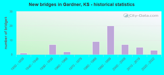
- New bridges - historical statistics
- 11930-1939
- 71950-1959
- 21960-1969
- 91980-1989
- 201990-1999
- 72000-2009
- 52010-2019
- 32020-2022
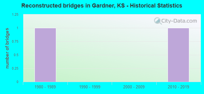
- Reconstructed bridges - Historical Statistics
- 11980-1989
- 01990-1999
- 02000-2009
- 12010-2019
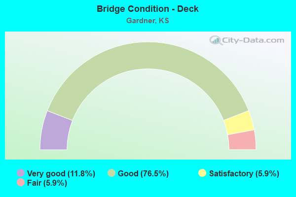
- Bridge Condition - Deck
- 11.8%Very good
- 76.5%Good
- 5.9%Satisfactory
- 5.9%Fair
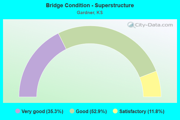
- Bridge Condition - Superstructure
- 35.3%Very good
- 52.9%Good
- 11.8%Satisfactory
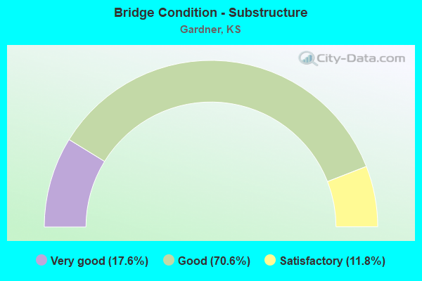
- Bridge Condition - Substructure
- 17.6%Very good
- 70.6%Good
- 11.8%Satisfactory
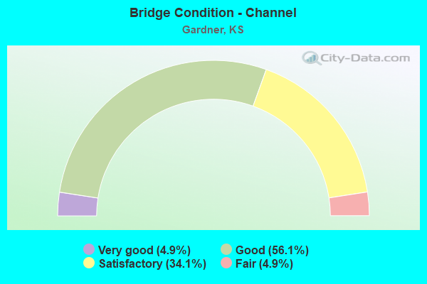
- Bridge Condition - Channel
- 4.9%Very good
- 56.1%Good
- 34.1%Satisfactory
- 4.9%Fair
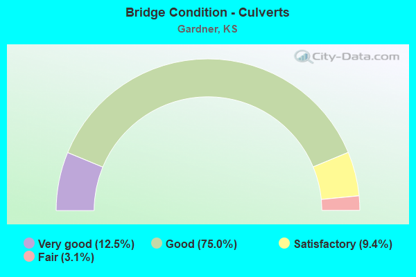
- Bridge Condition - Culverts
- 12.5%Very good
- 75.0%Good
- 9.4%Satisfactory
- 3.1%Fair
Find on map >> Show street view
Structure Number: 999905600462721, Location: 0.50 MI W I35 (Lat: 38.811944, Lng: -94.892500), Route carried "on" structure: US 56, Year Built: 1986, Status: Open, Structure Length: 0.63m (2.07ft), Average Daily Traffic: 7,100 (year 2020), Truck Traffic: 5%, Average Future Daily Traffic: 10,550 (year 2041), Design Load: H 20, Features Intersected: LITTLE BULL CREEK
Minimum Vertical Clearance: 30.47m (99.97ft), Kilometerpoint: 16.188, Lanes on structure: 4, Base Highway Network: Yes, Owner: State Highway Agency, Approaching Roadway Width: 20.7m (67.9ft), Material/Design: Concrete, Design/Construction: Culvert, Number Of Spans In Main Unit: 2, Length of Maximum Span: 3.0m (9.8ft), Curb-To-Curb Width: 20.7m (67.9ft), Out-to-Out Width: 39.2m (128.6ft)
Condition: Channel: Good, Culverts: Good, Operating Rating: 58.1 metric tons, Method Used To Determine Operating Rating: Load Factor (LF), Inventory Rating: 34.7 metric tons, Method Used To Determine Inventory Rating: Load Factor (LF), Structural Evaluation: Better than present minimum criteria, Deck Geometry: Superior to present desirable criteria, Waterway Adequacy: Better than present minimum criteria, Approach Roadway Alignment: Equal to present desirable criteria, Length Of Structure Improvement: 2.06m (6.76ft), Designated Inspection Frequency: Every 24 months, Inspection Date: May 2020, Deck Structure Type: Concrete Cast-file-Place, Wearing Surface/Protective System: Wearing Surface: Monolithic Concrete
Find on map >> Show street view
Structure Number: 999905600462891, Location: 9.01 MI NE MI COLN (Lat: 38.811111, Lng: -94.883611), Route carried "on" structure: US 56, Year Built: 1992, Status: Open, Structure Length: 13.41m (44.00ft), Average Daily Traffic: 3,550 (year 2020), Truck Traffic: 5%, Average Future Daily Traffic: 5,275 (year 2041), Design Load: HS 20, Features Intersected: I-35 HWY WL-EL
Minimum Vertical Clearance: 30.47m (99.97ft), Kilometerpoint: 16.953, Lanes on structure: 3, Lanes under structure: 5, Base Highway Network: Yes, Owner: State Highway Agency, Approaching Roadway Width: 13.4m (44.0ft), Skew: 5 degrees, Material/Design: Steel continuous, Design/Construction: Stringer/Multi-beam, Number Of Spans In Main Unit: 4, Length of Maximum Span: 41.8m (137.1ft), Curb-To-Curb Width: 13.4m (44.0ft), Out-to-Out Width: 13.9m (45.6ft)
Condition: Deck: Good, Superstructure: Good, Substructure: Good, Operating Rating: 56.2 metric tons, Method Used To Determine Operating Rating: Load Factor (LF), Inventory Rating: 33.6 metric tons, Method Used To Determine Inventory Rating: Load Factor (LF), Structural Evaluation: Better than present minimum criteria, Deck Geometry: Somewhat better than minimum adequacy, Underclear: Equal to present minimum criteria, Approach Roadway Alignment: Better than present minimum criteria, Length Of Structure Improvement: 43.98m (144.29ft), Designated Inspection Frequency: Every 24 months, Inspection Date: May 2020, Wearing Surface/Protective System: Wearing Surface: Epoxy Overlay, Deck Protection: Epoxy Coated Reinforcing
Find on map >> Show street view
Structure Number: 999905600462901, Location: 9.02 MI NE MI COLN (Lat: 38.811389, Lng: -94.883333), Route carried "on" structure: US 56, Year Built: 1992, Status: Open, Structure Length: 13.41m (44.00ft), Average Daily Traffic: 3,550 (year 2020), Truck Traffic: 5%, Average Future Daily Traffic: 5,275 (year 2041), Design Load: HS 20, Features Intersected: I-35 HWY WL-EL
Minimum Vertical Clearance: 30.47m (99.97ft), Kilometerpoint: 0.101, Lanes on structure: 2, Lanes under structure: 4, Base Highway Network: Yes (Inventory Route: 4620056, Subroute: 1), Owner: State Highway Agency, Approaching Roadway Width: 10.4m (34.1ft), Skew: 5 degrees, Material/Design: Steel continuous, Design/Construction: Stringer/Multi-beam, Number Of Spans In Main Unit: 4, Length of Maximum Span: 41.8m (137.1ft), Curb-To-Curb Width: 10.4m (34.1ft), Out-to-Out Width: 10.8m (35.4ft)
Condition: Deck: Good, Superstructure: Good, Substructure: Good, Operating Rating: 64.4 metric tons, Method Used To Determine Operating Rating: Load Factor (LF), Inventory Rating: 39.0 metric tons, Method Used To Determine Inventory Rating: Load Factor (LF), Structural Evaluation: Better than present minimum criteria, Deck Geometry: Somewhat better than minimum adequacy, Underclear: Equal to present minimum criteria, Approach Roadway Alignment: Better than present minimum criteria, Length Of Structure Improvement: 43.98m (144.29ft), Designated Inspection Frequency: Every 24 months, Inspection Date: May 2020, Wearing Surface/Protective System: Wearing Surface: Epoxy Overlay, Deck Protection: Epoxy Coated Reinforcing
Find on map >> Show street view
Structure Number: 999903500460091, Location: 5.75 MI NE MI COLN (Lat: 38.781389, Lng: -94.927222), Route carried "under" structure: Interstate 35, Year Built: 1959, Structure Length: 0. m, Average Daily Traffic: 16,179 (year 2020), Truck Traffic: 36%, Features Intersected: I35 HWY, WL-EL, Facility Carried by Structure: GARDNER ROAD
Minimum Vertical Clearance: 4.97m (16.31ft), Kilometerpoint: 9.271, Lanes on structure: 2, Lanes under structure: 4, Material/Design: Concrete continuous, Design/Construction: Box Beam or Girders - Multiple, Length of Maximum Span: 27.4m (89.9ft)
Find on map >> Show street view
Structure Number: 999903500460111, Location: 7.13 MI NE MI COLN (Lat: 38.795000, Lng: -94.908333), Route carried "under" structure: Interstate 35, Year Built: 1959, Structure Length: 0. m, Average Daily Traffic: 20,887 (year 2020), Truck Traffic: 28%, Features Intersected: I35 HWY, WL-EL, Facility Carried by Structure: MOONLIGHT RD
Minimum Vertical Clearance: 4.92m (16.14ft), Kilometerpoint: 11.497, Lanes on structure: 2, Lanes under structure: 4, Material/Design: Concrete continuous, Design/Construction: Box Beam or Girders - Multiple, Length of Maximum Span: 24.1m (79.1ft)
Find on map >> Show street view
Structure Number: 999903500460131, Location: 9.64 MI NE MI COLN (Lat: 38.816667, Lng: -94.871111), Route carried "under" structure: Interstate 35, Year Built: 1959, Structure Length: 0. m, Average Daily Traffic: 25,588 (year 2020), Truck Traffic: 23%, Features Intersected: I35 HWY, Facility Carried by Structure: CLARE RD
Minimum Vertical Clearance: 5.00m (16.40ft), Kilometerpoint: 15.543, Lanes on structure: 2, Lanes under structure: 4, Material/Design: Concrete continuous, Design/Construction: Box Beam or Girders - Multiple, Length of Maximum Span: 24.6m (80.7ft)
Find on map >> Show street view
Structure Number: 999905600462891, Location: 9.01 MI NE MI COLN (Lat: 38.811111, Lng: -94.883611), Route carried "under" structure: Interstate 35, Year Built: 1992, Structure Length: 0. m, Average Daily Traffic: 20,887 (year 2020), Truck Traffic: 28%, Features Intersected: I-35 HWY WL-EL, Facility Carried by Structure: US56/175TH ST EB
Minimum Vertical Clearance: 5.03m (16.50ft), Kilometerpoint: 14.276, Lanes on structure: 3, Lanes under structure: 5, Material/Design: Steel continuous, Design/Construction: Stringer/Multi-beam, Length of Maximum Span: 41.8m (137.1ft)
Find on map >> Show street view
Structure Number: 999905600462901, Location: 9.02 MI NE MI COLN (Lat: 38.811389, Lng: -94.883333), Route carried "under" structure: Interstate 35, Year Built: 1992, Structure Length: 0. m, Average Daily Traffic: 20,887 (year 2020), Truck Traffic: 28%, Features Intersected: I-35 HWY WL-EL, Facility Carried by Structure: US56/175TH ST WB
Minimum Vertical Clearance: 5.03m (16.50ft), Kilometerpoint: 14.289, Lanes on structure: 2, Lanes under structure: 4, Material/Design: Steel continuous, Design/Construction: Stringer/Multi-beam, Length of Maximum Span: 41.8m (137.1ft)