Bridge Statistics for Fruitport, Michigan (MI)
Condition, Traffic, Stress, Structural Evaluation, Project Costs
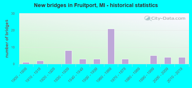
- New bridges - historical statistics
- 11900-1909
- 21910-1919
- 81930-1939
- 31940-1949
- 31950-1959
- 211960-1969
- 31970-1979
- 51990-1999
- 42000-2009
- 42010-2019

- Reconstructed bridges - Historical Statistics
- 11940-1949
- 01950-1959
- 01960-1969
- 11970-1979
- 41980-1989
- 51990-1999
- 12000-2009
- 12010-2019


- Bridge Condition - Deck
- 8.3%Very good
- 35.4%Good
- 29.2%Satisfactory
- 22.9%Fair
- 4.2%Poor

- Bridge Condition - Superstructure
- 4.2%Excellent
- 12.5%Very good
- 14.6%Good
- 29.2%Satisfactory
- 35.4%Fair
- 4.2%Poor

- Bridge Condition - Substructure
- 10.4%Very good
- 31.3%Good
- 43.8%Satisfactory
- 14.6%Fair

- Bridge Condition - Channel
- 6.9%Very good
- 34.5%Good
- 34.5%Satisfactory
- 24.1%Fair

- Bridge Condition - Culverts
- 50.0%Fair
- 50.0%Poor
Find on map >> Show street view
Structure Number: 331, Location: 4.3 MI N OF ALCONA COL (Lat: 44.918406, Lng: -83.437844), Route carried "on" structure: US 23, Year Built: 1936, Status: Open, Structure Length: 0.97m (3.18ft), Average Daily Traffic: 5,537 (year 2007), Truck Traffic: 5%, Average Future Daily Traffic: 7,351 (year 2018), Design Load: HS 25 or greater, Features Intersected: S BR DEVIL RIVER
Minimum Vertical Clearance: 30.48m (100.00ft), Kilometerpoint: 7.035, Lanes on structure: 2, Base Highway Network: Yes (Inventory Route: 102, Subroute: 9), Owner: State Highway Agency, Approaching Roadway Width: 13.4m (44.0ft), Skew: 3 degrees, Material/Design: Concrete, Design/Construction: Tee Beam, Number Of Spans In Main Unit: 1, Length of Maximum Span: 9.7m (31.8ft), Curb-To-Curb Width: 13.4m (44.0ft), Out-to-Out Width: 14.4m (47.2ft)
Condition: Deck: Fair, Superstructure: Satisfactory, Substructure: Satisfactory, Channel: Fair, Operating Rating: 68.7 metric tons, Method Used To Determine Operating Rating: Load Factor (LF) rating reported by rating factor (RF) method using MS18 loading, Inventory Rating: 41.1 metric tons, Method Used To Determine Inventory Rating: Load Factor (LF) rating reported by rating factor (RF) method using MS18 loading, Structural Evaluation: Equal to present minimum criteria, Deck Geometry: Equal to present minimum criteria, Waterway Adequacy: Equal to present minimum criteria, Approach Roadway Alignment: Somewhat better than minimum adequacy, Designated Inspection Frequency: Every 24 months, Inspection Date: May 2021, Deck Structure Type: Concrete Cast-file-Place, Wearing Surface/Protective System: Wearing Surface: Epoxy Overlay, Membrane: Other
Find on map >> Show street view
Structure Number: 456, Location: 2.1 MI N OF US-23 (Lat: 44.078061, Lng: -83.786494), Route carried "on" structure: County highway , Year Built: 1917, Status: Posted for load, Structure Length: 1.22m (4.00ft), Average Daily Traffic: 175 (year 2016), Truck Traffic: 10%, Average Future Daily Traffic: 273 (year 2036), Design Load: HS 20+Mod, Features Intersected: BIG CREEK A DRAIN, Facility Carried by Structure: CRAWFORD ROAD
Minimum Vertical Clearance: 30.48m (100.00ft), Kilometerpoint: 3.315, Lanes on structure: 2, Owner: County Highway Agency, Approaching Roadway Width: 7.9m (25.9ft), Material/Design: Steel, Design/Construction: Stringer/Multi-beam, Number Of Spans In Main Unit: 1, Length of Maximum Span: 11.8m (38.7ft), Curb-To-Curb Width: 5.5m (18.0ft), Out-to-Out Width: 5.6m (18.4ft)
Condition: Deck: Fair, Superstructure: Fair, Substructure: Satisfactory, Channel: Good, Operating Rating: 39.9 metric tons, Method Used To Determine Operating Rating: Load Factor (LF) rating reported by rating factor (RF) method using MS18 loading, Inventory Rating: 24.0 metric tons, Method Used To Determine Inventory Rating: Load Factor (LF) rating reported by rating factor (RF) method using MS18 loading, Structural Evaluation: Somewhat better than minimum adequacy, Deck Geometry: High priority of corrective action, Waterway Adequacy: Equal to present minimum criteria, Approach Roadway Alignment: Better than present minimum criteria, Bridge Posting: Required (Relationship of Operating Rating to Maximum Legal Load: 0.1 - 9.9% below), Length Of Structure Improvement: 2.13m (6.99ft), Designated Inspection Frequency: Every 24 months, Inspection Date: August 2021, Bridge Improvement Cost: $321,000, Roadway Improvement Cost: $50,000, Total Project Cost: $371,000, Deck Structure Type: Concrete Cast-file-Place, Wearing Surface/Protective System: Wearing Surface: Gravel
Find on map >> Show street view
Structure Number: 459, Location: 0.3 MI S OF WYATT RD (Lat: 44.009197, Lng: -83.947078), Route carried "on" structure: County highway , Year Built: 1977, Status: Open, Structure Length: 1.15m (3.77ft), Average Daily Traffic: 52 (year 1998), Average Future Daily Traffic: 30 (year 1977), Design Load: HS 20+Mod, Features Intersected: N BR PINE RIVER, Facility Carried by Structure: HUSAK ROAD
Minimum Vertical Clearance: 30.48m (100.00ft), Kilometerpoint: 0.209, Lanes on structure: 2, Owner: County Highway Agency, Approaching Roadway Width: 8.5m (27.9ft), Skew: 3 degrees, Material/Design: Wood or Timber, Design/Construction: Slab, Number Of Spans In Main Unit: 1, Length of Maximum Span: 10.9m (35.8ft), Curb-To-Curb Width: 8.5m (27.9ft), Out-to-Out Width: 9.1m (29.9ft)
Condition: Deck: Fair, Superstructure: Fair, Substructure: Satisfactory, Channel: Fair, Operating Rating: 51.8 metric tons, Method Used To Determine Operating Rating: Allowable Stress (AS), Inventory Rating: 26.4 metric tons, Method Used To Determine Inventory Rating: Allowable Stress (AS), Structural Evaluation: Somewhat better than minimum adequacy, Deck Geometry: Better than present minimum criteria, Waterway Adequacy: Superior to present desirable criteria, Approach Roadway Alignment: Somewhat better than minimum adequacy, Designated Inspection Frequency: Every 24 months, Inspection Date: August 2020, Deck Structure Type: Wood or Timber, Wearing Surface/Protective System: Wearing Surface: Wood or Timber
Find on map >> Show street view
Structure Number: 461, Location: 0.2 MI S OF BORDEAU ROAD (Lat: 43.936711, Lng: -84.006472), Route carried "on" structure: County highway , Year Built: 2017, Status: Open, Structure Length: 2.89m (9.48ft), Average Daily Traffic: 275 (year 2016), Truck Traffic: 5%, Average Future Daily Traffic: 336 (year 2036), Design Load: Greater than HL93, Features Intersected: S BR PINE RIVER, Facility Carried by Structure: MELITA ROAD
Minimum Vertical Clearance: 30.48m (100.00ft), Kilometerpoint: 2.863, Lanes on structure: 2, Owner: County Highway Agency, Approaching Roadway Width: 8.5m (27.9ft), Skew: 3 degrees, Material/Design: Prestressed concrete, Design/Construction: Stringer/Multi-beam, Number Of Spans In Main Unit: 1, Length of Maximum Span: 27.6m (90.6ft), Curb-To-Curb Width: 8.7m (28.5ft), Out-to-Out Width: 9.6m (31.5ft)
Condition: Deck: Very good, Superstructure: Very good, Substructure: Very good, Channel: Good, Operating Rating: 76.1 metric tons, Method Used To Determine Operating Rating: Load and Resistance Factor Rating (LRFR) rating reported by rating factor(RF) method using HL-93 loadings, Inventory Rating: 45.7 metric tons, Method Used To Determine Inventory Rating: Load and Resistance Factor Rating (LRFR) rating reported by rating factor(RF) method using HL-93 loadings, Structural Evaluation: Equal to present desirable criteria, Deck Geometry: Equal to present minimum criteria, Waterway Adequacy: Equal to present desirable criteria, Approach Roadway Alignment: Better than present minimum criteria, Length Of Structure Improvement: 1.59m (5.22ft), Designated Inspection Frequency: Every 24 months, Inspection Date: August 2021, Bridge Improvement Cost: $412,000, Roadway Improvement Cost: $78,000, Total Project Cost: $490,000, Deck Structure Type: Concrete Cast-file-Place, Wearing Surface/Protective System: Wearing Surface: Monolithic Concrete, Deck Protection: Epoxy Coated Reinforcing
Find on map >> Show street view
Structure Number: 593, Location: 3.0 MI N OF PINCONNING (Lat: 43.896811, Lng: -83.966133), Route carried "on" structure: State highway 13, Year Built: 1938, Year Reconstructed: 1952, Status: Open, Structure Length: 0.82m (2.69ft), Average Daily Traffic: 8,300 (year 2015), Truck Traffic: 4%, Average Future Daily Traffic: 9,545 (year 2035), Design Load: H 15, Features Intersected: WHITE FEATHER CREEK
Minimum Vertical Clearance: 30.48m (100.00ft), Kilometerpoint: 41.283, Lanes on structure: 4, Base Highway Network: Yes (Inventory Route: 76, Subroute: 10), Owner: State Highway Agency, Approaching Roadway Width: 21.3m (69.9ft), Material/Design: Concrete, Design/Construction: Tee Beam, Number Of Spans In Main Unit: 1, Length of Maximum Span: 6.8m (22.3ft), Curb or Sidewalk Widths: Left: 0.4m (1.3ft), Right: 0.4m (1.3ft), Curb-To-Curb Width: 20.4m (66.9ft), Out-to-Out Width: 22.2m (72.8ft)
Condition: Deck: Satisfactory, Superstructure: Fair, Substructure: Satisfactory, Channel: Fair, Operating Rating: 46.3 metric tons, Method Used To Determine Operating Rating: Load Factor (LF) rating reported by rating factor (RF) method using MS18 loading, Inventory Rating: 27.5 metric tons, Method Used To Determine Inventory Rating: Load Factor (LF) rating reported by rating factor (RF) method using MS18 loading, Structural Evaluation: Somewhat better than minimum adequacy, Deck Geometry: Superior to present desirable criteria, Waterway Adequacy: Equal to present desirable criteria, Approach Roadway Alignment: Somewhat better than minimum adequacy, Length Of Structure Improvement: 0.82m (2.69ft), Designated Inspection Frequency: Every 24 months, Inspection Date: July 2021, Bridge Improvement Cost: $21,000, Roadway Improvement Cost: $2,000, Total Project Cost: $24,000, Deck Structure Type: Concrete Cast-file-Place, Wearing Surface/Protective System: Wearing Surface: Bituminous, Membrane: Preformed Fabric
Find on map >> Show street view
Structure Number: 1568, Location: 0.8 MI W OF M-48 (Lat: 45.978956, Lng: -84.103853), Route carried "on" structure: State highway 134, Year Built: 1939, Status: Open, Structure Length: 0.82m (2.69ft), Average Daily Traffic: 828 (year 2007), Truck Traffic: 6%, Average Future Daily Traffic: 963 (year 2018), Design Load: H 15, Features Intersected: TROUT CREEK
Minimum Vertical Clearance: 30.48m (100.00ft), Kilometerpoint: 0.917, Lanes on structure: 2, Base Highway Network: Yes (Inventory Route: 146, Subroute: 5), Owner: State Highway Agency, Approaching Roadway Width: 10.1m (33.1ft), Material/Design: Concrete, Design/Construction: Tee Beam, Number Of Spans In Main Unit: 1, Length of Maximum Span: 8.2m (26.9ft), Curb or Sidewalk Widths: Left: 0.4m (1.3ft), Right: 0.4m (1.3ft), Curb-To-Curb Width: 10.1m (33.1ft), Out-to-Out Width: 11.7m (38.4ft)
Condition: Deck: Fair, Superstructure: Satisfactory, Substructure: Good, Channel: Satisfactory, Operating Rating: 52.2 metric tons, Method Used To Determine Operating Rating: Load and Resistance Factor Rating (LRFR) rating reported by rating factor(RF) method using HL-93 loadings, Inventory Rating: 40.2 metric tons, Method Used To Determine Inventory Rating: Load and Resistance Factor Rating (LRFR) rating reported by rating factor(RF) method using HL-93 loadings, Structural Evaluation: Equal to present minimum criteria, Deck Geometry: Equal to present minimum criteria, Waterway Adequacy: Equal to present minimum criteria, Approach Roadway Alignment: Better than present minimum criteria, Designated Inspection Frequency: Every 24 months, Inspection Date: May 2020, Deck Structure Type: Concrete Cast-file-Place, Wearing Surface/Protective System: Wearing Surface: Bituminous
Find on map >> Show street view
Structure Number: 1569, Location: 0.4 MI E OF M-48 (Lat: 45.970103, Lng: -84.076111), Route carried "on" structure: State highway 134, Year Built: 1947, Status: Open, Structure Length: 1.06m (3.48ft), Average Daily Traffic: 759 (year 2007), Truck Traffic: 9%, Average Future Daily Traffic: 811 (year 2018), Design Load: HS 20, Features Intersected: ALBANY CREEK
Minimum Vertical Clearance: 30.48m (100.00ft), Kilometerpoint: 3.291, Lanes on structure: 2, Base Highway Network: Yes (Inventory Route: 146, Subroute: 5), Owner: State Highway Agency, Approaching Roadway Width: 11.0m (36.1ft), Skew: 1 degrees, Material/Design: Steel, Design/Construction: Stringer/Multi-beam, Number Of Spans In Main Unit: 1, Length of Maximum Span: 10.6m (34.8ft), Curb or Sidewalk Widths: Left: 0.4m (1.3ft), Right: 0.4m (1.3ft), Curb-To-Curb Width: 11.0m (36.1ft), Out-to-Out Width: 12.4m (40.7ft)
Condition: Deck: Good, Superstructure: Good, Substructure: Good, Channel: Satisfactory, Operating Rating: 61.2 metric tons, Method Used To Determine Operating Rating: Load Factor (LF) rating reported by rating factor (RF) method using MS18 loading, Inventory Rating: 36.3 metric tons, Method Used To Determine Inventory Rating: Load Factor (LF) rating reported by rating factor (RF) method using MS18 loading, Structural Evaluation: Better than present minimum criteria, Deck Geometry: Better than present minimum criteria, Waterway Adequacy: Equal to present desirable criteria, Approach Roadway Alignment: Better than present minimum criteria, Designated Inspection Frequency: Every 24 months, Inspection Date: May 2020, Deck Structure Type: Concrete Cast-file-Place, Wearing Surface/Protective System: Wearing Surface: Bituminous
Find on map >> Show street view
Structure Number: 3311, Location: 0.25 MI N OF SQUAWFIELD (Lat: 41.817581, Lng: -84.419597), Route carried "on" structure: County highway 3083, Year Built: 1954, Status: Posted for load, Structure Length: 1.22m (4.00ft), Average Daily Traffic: 608 (year 2013), Average Future Daily Traffic: 996 (year 2038), Design Load: H 15, Features Intersected: E BR ST JOSEPH OF MAUMEE, Facility Carried by Structure: WALDRON ROAD
Minimum Vertical Clearance: 30.48m (100.00ft), Kilometerpoint: 12.462, Lanes on structure: 2, Owner: County Highway Agency, Approaching Roadway Width: 8.8m (28.9ft), Material/Design: Steel, Design/Construction: Stringer/Multi-beam, Number Of Spans In Main Unit: 1, Length of Maximum Span: 11.8m (38.7ft), Curb-To-Curb Width: 9.1m (29.9ft), Out-to-Out Width: 10.8m (35.4ft)
Condition: Deck: Satisfactory, Superstructure: Satisfactory, Substructure: Satisfactory, Channel: Satisfactory, Operating Rating: 35.8 metric tons, Method Used To Determine Operating Rating: Load Factor (LF), Inventory Rating: 21.4 metric tons, Method Used To Determine Inventory Rating: Load Factor (LF), Structural Evaluation: Somewhat better than minimum adequacy, Deck Geometry: Equal to present minimum criteria, Waterway Adequacy: Equal to present desirable criteria, Approach Roadway Alignment: Better than present minimum criteria, Bridge Posting: Required (Relationship of Operating Rating to Maximum Legal Load: 30.0 - 39.9% below), Designated Inspection Frequency: Every 24 months, Inspection Date: November 2020, Deck Structure Type: Concrete Cast-file-Place, Wearing Surface/Protective System: Wearing Surface: Bituminous
Find on map >> Show street view
Structure Number: 3312, Location: 0.3 MI N MOORE ROAD (Lat: 41.953994, Lng: -84.631589), Route carried "on" structure: County highway 3039, Year Built: 1970, Status: Open, Structure Length: 0.76m (2.49ft), Average Daily Traffic: 1,760 (year 2013), Average Future Daily Traffic: 2,887 (year 2038), Design Load: HS 20+Mod, Features Intersected: BEEBE CREEK, Facility Carried by Structure: HILLSDALE ROAD
Minimum Vertical Clearance: 30.48m (100.00ft), Kilometerpoint: 3.407, Lanes on structure: 2, Owner: County Highway Agency, Approaching Roadway Width: 10.4m (34.1ft), Material/Design: Steel, Design/Construction: Culvert, Number Of Spans In Main Unit: 2, Length of Maximum Span: 3.0m (9.8ft)
Condition: Channel: Satisfactory, Culverts: Fair, Operating Rating: 97.2 metric tons, Method Used To Determine Operating Rating: Load Factor (LF) rating reported by rating factor (RF) method using MS18 loading, Inventory Rating: 60.6 metric tons, Method Used To Determine Inventory Rating: Load Factor (LF) rating reported by rating factor (RF) method using MS18 loading, Structural Evaluation: Somewhat better than minimum adequacy, Waterway Adequacy: Better than present minimum criteria, Approach Roadway Alignment: Equal to present desirable criteria, Designated Inspection Frequency: Every 24 months, Inspection Date: November 2020, Wearing Surface/Protective System: Wearing Surface: Bituminous
Find on map >> Show street view
Structure Number: 3313, Location: 0.1 MILE SOUTH OF BALL RD (Lat: 41.962100, Lng: -84.592839), Route carried "on" structure: County highway 3049, Year Built: 1930, Status: Open, Structure Length: 0.97m (3.18ft), Average Daily Traffic: 1,927 (year 2013), Average Future Daily Traffic: 3,161 (year 2038), Design Load: HS 20+Mod, Features Intersected: BEEBE CREEK, Facility Carried by Structure: MILNES ROAD
Minimum Vertical Clearance: 30.48m (100.00ft), Kilometerpoint: 5.168, Lanes on structure: 2, Owner: County Highway Agency, Approaching Roadway Width: 10.1m (33.1ft), Material/Design: Concrete, Design/Construction: Tee Beam, Number Of Spans In Main Unit: 1, Length of Maximum Span: 9.4m (30.8ft), Curb-To-Curb Width: 6.7m (22.0ft), Out-to-Out Width: 8.0m (26.2ft)
Condition: Deck: Fair, Superstructure: Fair, Substructure: Fair, Channel: Satisfactory, Operating Rating: 48.6 metric tons, Method Used To Determine Operating Rating: Allowable Stress (AS), Inventory Rating: 22.6 metric tons, Method Used To Determine Inventory Rating: Allowable Stress (AS), Structural Evaluation: Somewhat better than minimum adequacy, Deck Geometry: High priority of corrective action, Waterway Adequacy: Equal to present desirable criteria, Approach Roadway Alignment: Equal to present desirable criteria, Designated Inspection Frequency: Every 24 months, Inspection Date: November 2020, Deck Structure Type: Concrete Cast-file-Place, Wearing Surface/Protective System: Wearing Surface: Bituminous
Find on map >> Show street view
Structure Number: 3314, Location: 0.4 MILE S OF STRUBLE RD (Lat: 42.037778, Lng: -84.506639), Route carried "on" structure: County highway 3055, Year Built: 1990, Status: Open, Structure Length: 0.76m (2.49ft), Average Daily Traffic: 1,055 (year 2013), Average Future Daily Traffic: 1,731 (year 2038), Design Load: HS 20, Features Intersected: S BR KALAMAZOO RIVER, Facility Carried by Structure: MOSCOW ROAD
Minimum Vertical Clearance: 30.48m (100.00ft), Kilometerpoint: 5.784, Lanes on structure: 2, Owner: County Highway Agency, Approaching Roadway Width: 39.9m (130.9ft), Skew: 3 degrees, Material/Design: Prestressed concrete, Design/Construction: Box Beam or Girders - Multiple, Number Of Spans In Main Unit: 1, Length of Maximum Span: 7.3m (24.0ft), Curb-To-Curb Width: 9.8m (32.2ft), Out-to-Out Width: 10.6m (34.8ft)
Condition: Deck: Good, Superstructure: Satisfactory, Substructure: Good, Channel: Very good, Operating Rating: 50.5 metric tons, Method Used To Determine Operating Rating: Load Factor (LF), Inventory Rating: 30.2 metric tons, Method Used To Determine Inventory Rating: Load Factor (LF), Structural Evaluation: Equal to present minimum criteria, Deck Geometry: Somewhat better than minimum adequacy, Waterway Adequacy: Equal to present desirable criteria, Approach Roadway Alignment: Equal to present desirable criteria, Designated Inspection Frequency: Every 24 months, Inspection Date: November 2020, Deck Structure Type: Concrete Precast Panels, Wearing Surface/Protective System: Wearing Surface: Bituminous, Membrane: Other
Find on map >> Show street view
Structure Number: 3315, Location: 1.1 MI N OF LITCHFIELD (Lat: 42.059572, Lng: -84.807139), Route carried "on" structure: County highway , Year Built: 1965, Status: Open, Structure Length: 2.31m (7.58ft), Average Daily Traffic: 418 (year 2013), Average Future Daily Traffic: 686 (year 2038), Design Load: HS 20, Features Intersected: ST JOSEPH RIVER, Facility Carried by Structure: HADLEY ROAD
Minimum Vertical Clearance: 30.48m (100.00ft), Kilometerpoint: 4.981, Lanes on structure: 2, Owner: County Highway Agency, Approaching Roadway Width: 10.1m (33.1ft), Material/Design: Prestressed concrete, Design/Construction: Box Beam or Girders - Multiple, Number Of Spans In Main Unit: 2, Length of Maximum Span: 11.2m (36.7ft), Curb-To-Curb Width: 9.1m (29.9ft), Out-to-Out Width: 9.2m (30.2ft)
Condition: Deck: Satisfactory, Superstructure: Satisfactory, Substructure: Good, Channel: Good, Operating Rating: 71.8 metric tons, Method Used To Determine Operating Rating: Load Factor (LF), Inventory Rating: 43.0 metric tons, Method Used To Determine Inventory Rating: Load Factor (LF), Structural Evaluation: Equal to present minimum criteria, Deck Geometry: Equal to present minimum criteria, Waterway Adequacy: Equal to present desirable criteria, Approach Roadway Alignment: Equal to present desirable criteria, Designated Inspection Frequency: Every 24 months, Inspection Date: November 2020, Deck Structure Type: Concrete Precast Panels, Wearing Surface/Protective System: Wearing Surface: Bituminous
Find on map >> Show street view
Structure Number: 3316, Location: 0.8 MI N OF LITCHFIELD (Lat: 42.054261, Lng: -84.651458), Route carried "on" structure: County highway 3031, Year Built: 1910, Status: Open, Structure Length: 0.94m (3.08ft), Average Daily Traffic: 2,189 (year 2013), Average Future Daily Traffic: 3,591 (year 2038), Design Load: HS 20+Mod, Features Intersected: S BR KALAMAZOO RIVER, Facility Carried by Structure: CONCORD ROAD
Minimum Vertical Clearance: 30.48m (100.00ft), Kilometerpoint: 7.320, Lanes on structure: 2, Owner: County Highway Agency, Approaching Roadway Width: 10.4m (34.1ft), Material/Design: Concrete, Design/Construction: Tee Beam, Number Of Spans In Main Unit: 1, Length of Maximum Span: 9.1m (29.9ft), Curb-To-Curb Width: 8.8m (28.9ft), Out-to-Out Width: 9.8m (32.2ft)
Condition: Deck: Fair, Superstructure: Fair, Substructure: Satisfactory, Channel: Good, Operating Rating: 51.5 metric tons, Method Used To Determine Operating Rating: Load Factor (LF) rating reported by rating factor (RF) method using MS18 loading, Inventory Rating: 30.8 metric tons, Method Used To Determine Inventory Rating: Load Factor (LF) rating reported by rating factor (RF) method using MS18 loading, Structural Evaluation: Somewhat better than minimum adequacy, Deck Geometry: Meets minimum limits, Waterway Adequacy: Equal to present desirable criteria, Approach Roadway Alignment: Better than present minimum criteria, Designated Inspection Frequency: Every 24 months, Inspection Date: November 2020, Deck Structure Type: Concrete Cast-file-Place, Wearing Surface/Protective System: Wearing Surface: Bituminous
Find on map >> Show street view
Structure Number: 4558, Location: 1.6 MI N OF I-94 (Lat: 42.259872, Lng: -85.651031), Route carried "on" structure: County highway 2005, Year Built: 2008, Status: Open, Structure Length: 7.59m (24.90ft), Average Daily Traffic: 11,200 (year 2004), Truck Traffic: 4%, Average Future Daily Traffic: 15,000 (year 2015), Design Load: HS 20+Mod, Features Intersected: US-131, Facility Carried by Structure: PARKVIEW (M AVE)
Minimum Vertical Clearance: 30.48m (100.00ft), Kilometerpoint: 2.075, Lanes on structure: 3, Lanes under structure: 4, Owner: State Highway Agency, Approaching Roadway Width: 16.2m (53.1ft), Skew: 2 degrees, Material/Design: Prestressed concrete, Design/Construction: Stringer/Multi-beam, Number Of Spans In Main Unit: 4, Length of Maximum Span: 23.4m (76.8ft), Curb-To-Curb Width: 16.2m (53.1ft), Out-to-Out Width: 16.9m (55.4ft)
Condition: Deck: Good, Superstructure: Satisfactory, Substructure: Good, Operating Rating: 79.1 metric tons, Method Used To Determine Operating Rating: Load Factor (LF) rating reported by rating factor (RF) method using MS18 loading, Inventory Rating: 24.3 metric tons, Method Used To Determine Inventory Rating: Load Factor (LF) rating reported by rating factor (RF) method using MS18 loading, Structural Evaluation: Equal to present minimum criteria, Deck Geometry: Better than present minimum criteria, Underclear: Meets minimum limits, Approach Roadway Alignment: Equal to present desirable criteria, Designated Inspection Frequency: Every 24 months, Inspection Date: September 2020, Deck Structure Type: Concrete Precast Panels, Wearing Surface/Protective System: Wearing Surface: Bituminous, Membrane: Preformed Fabric, Deck Protection: Epoxy Coated Reinforcing
Find on map >> Show street view
Structure Number: 4588, Location: 2.1 MI E OF VAN BUREN COL (Lat: 42.227903, Lng: -85.725728), Route carried "on" structure: County highway , Year Built: 1959, Status: Open, Structure Length: 7.89m (25.89ft), Average Daily Traffic: 1,111 (year 1997), Truck Traffic: 3%, Average Future Daily Traffic: 2,000 (year 2015), Design Load: H 15, Features Intersected: I-94, Facility Carried by Structure: 4 TH STREET
Minimum Vertical Clearance: 30.48m (100.00ft), Kilometerpoint: 0.536, Lanes on structure: 2, Lanes under structure: 4, Owner: State Highway Agency, Approaching Roadway Width: 9.4m (30.8ft), Skew: 2 degrees, Material/Design: Concrete continuous, Design/Construction: Tee Beam, Number Of Spans In Main Unit: 4, Length of Maximum Span: 24.7m (81.0ft), Curb or Sidewalk Widths: Left: 0.1m (0.3ft), Right: 0.1m (0.3ft), Curb-To-Curb Width: 8.1m (26.6ft), Out-to-Out Width: 10.1m (33.1ft)
Condition: Deck: Satisfactory, Superstructure: Fair, Substructure: Satisfactory, Operating Rating: 50.2 metric tons, Method Used To Determine Operating Rating: Load Factor (LF), Inventory Rating: 30.1 metric tons, Method Used To Determine Inventory Rating: Load Factor (LF), Structural Evaluation: Somewhat better than minimum adequacy, Deck Geometry: Meets minimum limits, Underclear: High priority of corrective action, Approach Roadway Alignment: Better than present minimum criteria, Length Of Structure Improvement: 7.90m (25.92ft), Designated Inspection Frequency: Every 24 months, Inspection Date: September 2020, Bridge Improvement Cost: $90,000, Roadway Improvement Cost: $9,000, Total Project Cost: $106,000, Deck Structure Type: Concrete Cast-file-Place, Wearing Surface/Protective System: Wearing Surface: Latex Concrete
Find on map >> Show street view
Structure Number: 4589, Location: 3.3 MI E OF VAN BUREN COL (Lat: 42.235614, Lng: -85.706208), Route carried "on" structure: County highway 3909, Year Built: 1959, Status: Open, Structure Length: 7.83m (25.69ft), Average Daily Traffic: 2,400 (year 1995), Truck Traffic: 3%, Average Future Daily Traffic: 3,000 (year 2015), Design Load: H 15, Features Intersected: I-94, Facility Carried by Structure: 6 TH STREET
Minimum Vertical Clearance: 30.48m (100.00ft), Kilometerpoint: 3.034, Lanes on structure: 2, Lanes under structure: 4, Owner: State Highway Agency, Approaching Roadway Width: 9.4m (30.8ft), Skew: 2 degrees, Material/Design: Concrete continuous, Design/Construction: Tee Beam, Number Of Spans In Main Unit: 4, Length of Maximum Span: 24.3m (79.7ft), Curb or Sidewalk Widths: Left: 0.1m (0.3ft), Right: 0.1m (0.3ft), Curb-To-Curb Width: 8.0m (26.2ft), Out-to-Out Width: 10.1m (33.1ft)
Condition: Deck: Satisfactory, Superstructure: Satisfactory, Substructure: Satisfactory, Operating Rating: 51.8 metric tons, Method Used To Determine Operating Rating: Load Factor (LF) rating reported by rating factor (RF) method using MS18 loading, Inventory Rating: 31.1 metric tons, Method Used To Determine Inventory Rating: Load Factor (LF) rating reported by rating factor (RF) method using MS18 loading, Structural Evaluation: Equal to present minimum criteria, Deck Geometry: High priority of corrective action, Underclear: Meets minimum limits, Approach Roadway Alignment: Equal to present desirable criteria, Length Of Structure Improvement: 7.84m (25.72ft), Designated Inspection Frequency: Every 24 months, Inspection Date: September 2020, Bridge Improvement Cost: $89,000, Roadway Improvement Cost: $9,000, Total Project Cost: $105,000, Deck Structure Type: Concrete Cast-file-Place, Wearing Surface/Protective System: Wearing Surface: Latex Concrete
Find on map >> Show street view
Structure Number: 4591, Location: 0.6 MI W OF US-131 (Lat: 42.237811, Lng: -85.648794), Route carried "on" structure: Interstate 94, Year Built: 2008, Status: Open, Structure Length: 4.60m (15.09ft), Average Daily Traffic: 19,866 (year 2007), Truck Traffic: 25%, Average Future Daily Traffic: 28,005 (year 2025), Design Load: HS 25 or greater, Features Intersected: 12 TH STREET
Minimum Vertical Clearance: 30+ m (98+ ft), Kilometerpoint: 10.022, Lanes on structure: 3, Lanes under structure: 2, Base Highway Network: Yes (Inventory Route: 1, Subroute: 3), Owner: State Highway Agency, Approaching Roadway Width: 19.5m (64.0ft), Skew: 1 degrees, Material/Design: Prestressed concrete, Design/Construction: Stringer/Multi-beam, Number Of Spans In Main Unit: 3, Length of Maximum Span: 25.4m (83.3ft), Curb-To-Curb Width: 19.5m (64.0ft), Out-to-Out Width: 20.5m (67.3ft)
Condition: Deck: Good, Superstructure: Good, Substructure: Good, Operating Rating: 61.2 metric tons, Method Used To Determine Operating Rating: Load Factor (LF) rating reported by rating factor (RF) method using MS18 loading, Inventory Rating: 36.6 metric tons, Method Used To Determine Inventory Rating: Load Factor (LF) rating reported by rating factor (RF) method using MS18 loading, Structural Evaluation: Better than present minimum criteria, Deck Geometry: Superior to present desirable criteria, Underclear: Better than present minimum criteria, Approach Roadway Alignment: Equal to present desirable criteria, Designated Inspection Frequency: Every 24 months, Inspection Date: July 2020, Deck Structure Type: Concrete Cast-file-Place, Wearing Surface/Protective System: Wearing Surface: Monolithic Concrete, Deck Protection: Epoxy Coated Reinforcing
Find on map >> Show street view
Structure Number: 4592, Location: 0.6 MI W OF US-131 (Lat: 42.238061, Lng: -85.648919), Route carried "on" structure: Interstate 94, Year Built: 2007, Status: Open, Structure Length: 4.60m (15.09ft), Average Daily Traffic: 19,866 (year 2007), Truck Traffic: 25%, Average Future Daily Traffic: 28,005 (year 2025), Design Load: HS 25 or greater, Features Intersected: 12 TH STREET
Minimum Vertical Clearance: 30+ m (98+ ft), Kilometerpoint: 10.012, Lanes on structure: 4, Lanes under structure: 2, Base Highway Network: Yes (Inventory Route: 2, Subroute: 5), Owner: State Highway Agency, Approaching Roadway Width: 23.2m (76.1ft), Skew: 1 degrees, Material/Design: Prestressed concrete, Design/Construction: Stringer/Multi-beam, Number Of Spans In Main Unit: 3, Length of Maximum Span: 25.4m (83.3ft), Curb-To-Curb Width: 23.2m (76.1ft), Out-to-Out Width: 24.1m (79.1ft)
Condition: Deck: Good, Superstructure: Very good, Substructure: Very good, Operating Rating: 61.9 metric tons, Method Used To Determine Operating Rating: Load Factor (LF) rating reported by rating factor (RF) method using MS18 loading, Inventory Rating: 36.9 metric tons, Method Used To Determine Inventory Rating: Load Factor (LF) rating reported by rating factor (RF) method using MS18 loading, Structural Evaluation: Equal to present desirable criteria, Deck Geometry: Superior to present desirable criteria, Underclear: Better than present minimum criteria, Approach Roadway Alignment: Better than present minimum criteria, Designated Inspection Frequency: Every 24 months, Inspection Date: July 2020, Deck Structure Type: Concrete Cast-file-Place, Wearing Surface/Protective System: Wearing Surface: Integral Concrete, Deck Protection: Epoxy Coated Reinforcing
Find on map >> Show street view
Structure Number: 4599, Location: AT SE LIMITS OF AUGUSTA (Lat: 42.335239, Lng: -85.344981), Route carried "on" structure: State highway 96, Year Built: 1962, Year Reconstructed: 1994, Status: Open, Structure Length: 6.00m (19.69ft), Average Daily Traffic: 6,843 (year 2007), Truck Traffic: 4%, Average Future Daily Traffic: 9,445 (year 2018), Design Load: HS 20, Features Intersected: KALAMAZOO RIVER
Minimum Vertical Clearance: 30.48m (100.00ft), Kilometerpoint: 9.447, Lanes on structure: 2, Base Highway Network: Yes (, Subroute: 10), Owner: State Highway Agency, Approaching Roadway Width: 14.0m (45.9ft), Skew: 2 degrees, Material/Design: Prestressed concrete, Design/Construction: Box Beam or Girders - Multiple, Number Of Spans In Main Unit: 3, Length of Maximum Span: 20.1m (65.9ft), Curb-To-Curb Width: 13.6m (44.6ft), Out-to-Out Width: 14.3m (46.9ft)
Condition: Deck: Good, Superstructure: Fair, Substructure: Fair, Channel: Fair, Operating Rating: 63.5 metric tons, Method Used To Determine Operating Rating: Load Factor (LF) rating reported by rating factor (RF) method using MS18 loading, Inventory Rating: 32.4 metric tons, Method Used To Determine Inventory Rating: Load Factor (LF) rating reported by rating factor (RF) method using MS18 loading, Structural Evaluation: Somewhat better than minimum adequacy, Deck Geometry: Superior to present desirable criteria, Waterway Adequacy: Equal to present desirable criteria, Approach Roadway Alignment: Equal to present desirable criteria, Designated Inspection Frequency: Every 24 months, Inspection Date: July 2020, Deck Structure Type: Concrete Cast-file-Place, Wearing Surface/Protective System: Wearing Surface: Monolithic Concrete, Deck Protection: Epoxy Coated Reinforcing
Find on map >> Show street view
Structure Number: 4601, Location: 0.2 MI E OF KALAMAZOO (Lat: 42.284917, Lng: -85.552539), Route carried "on" structure: State highway 96, Year Built: 1930, Year Reconstructed: 1975, Status: Open, Structure Length: 5.94m (19.49ft), Average Daily Traffic: 5,183 (year 2007), Truck Traffic: 7%, Average Future Daily Traffic: 5,515 (year 2018), Design Load: HS 20, Features Intersected: KALAMAZOO RIVER
Minimum Vertical Clearance: 30.48m (100.00ft), Kilometerpoint: 2.100, Lanes on structure: 3, Base Highway Network: Yes (, Subroute: 6), Owner: State Highway Agency, Approaching Roadway Width: 14.2m (46.6ft), Material/Design: Steel, Design/Construction: Stringer/Multi-beam, Number Of Spans In Main Unit: 3, Length of Maximum Span: 19.8m (65.0ft), Curb-To-Curb Width: 15.1m (49.5ft), Out-to-Out Width: 16.5m (54.1ft)
Condition: Deck: Fair, Superstructure: Fair, Substructure: Fair, Channel: Fair, Operating Rating: 78.1 metric tons, Method Used To Determine Operating Rating: Load Factor (LF), Inventory Rating: 46.8 metric tons, Method Used To Determine Inventory Rating: Load Factor (LF), Structural Evaluation: Somewhat better than minimum adequacy, Deck Geometry: Equal to present minimum criteria, Waterway Adequacy: Equal to present desirable criteria, Approach Roadway Alignment: Equal to present desirable criteria, Designated Inspection Frequency: Every 24 months, Underwater Inspection Frequency: Every 60 months, Inspection Date: July 2020, Underwater Inspection Date: August 2017, Deck Structure Type: Concrete Cast-file-Place, Wearing Surface/Protective System: Wearing Surface: Monolithic Concrete
Find on map >> Show street view
Structure Number: 4606, Location: 1.9 M N OF I-94 (Lat: 42.286722, Lng: -85.530778), Route carried "on" structure: County highway 2005, Year Built: 1967, Year Reconstructed: 2003, Status: Open, Structure Length: 3.41m (11.19ft), Average Daily Traffic: 3,200 (year 1988), Average Future Daily Traffic: 3,680 (year 2008), Design Load: HS 20+Mod, Features Intersected: M-96 (KING HIGHWAY), Facility Carried by Structure: SPRINKLE RD
Minimum Vertical Clearance: 30+ m (98+ ft), Kilometerpoint: 12.745, Lanes on structure: 5, Lanes under structure: 2, Base Highway Network: Yes (Inventory Route: 1, Subroute: 6), Owner: State Highway Agency, Approaching Roadway Width: 23.9m (78.4ft), Material/Design: Prestressed concrete, Design/Construction: Box Beam or Girders - Multiple, Number Of Spans In Main Unit: 3, Length of Maximum Span: 14.9m (48.9ft), Curb-To-Curb Width: 24.4m (80.1ft), Out-to-Out Width: 25.3m (83.0ft)
Condition: Deck: Good, Superstructure: Satisfactory, Substructure: Good, Operating Rating: 97.2 metric tons, Method Used To Determine Operating Rating: Load Factor (LF) rating reported by rating factor (RF) method using MS18 loading, Inventory Rating: 68.4 metric tons, Method Used To Determine Inventory Rating: Load Factor (LF) rating reported by rating factor (RF) method using MS18 loading, Structural Evaluation: Equal to present minimum criteria, Deck Geometry: Superior to present desirable criteria, Underclear: Somewhat better than minimum adequacy, Approach Roadway Alignment: Equal to present desirable criteria, Designated Inspection Frequency: Every 24 months, Inspection Date: September 2020, Deck Structure Type: Concrete Cast-file-Place, Wearing Surface/Protective System: Wearing Surface: Monolithic Concrete, Deck Protection: Epoxy Coated Reinforcing
Find on map >> Show street view
Structure Number: 4607, Location: 3.2 MI E OF US-131 (Lat: 42.315053, Lng: -85.603039), Route carried "on" structure: Business US 131, Year Built: 1963, Status: Open, Structure Length: 4.21m (13.81ft), Average Daily Traffic: 3,343 (year 2007), Truck Traffic: 9%, Average Future Daily Traffic: 3,630 (year 2018), Design Load: HS 20, Features Intersected: DOUGLAS AVE
Minimum Vertical Clearance: 30.48m (100.00ft), Kilometerpoint: 3.798, Lanes on structure: 3, Lanes under structure: 4, Base Highway Network: Yes (, Subroute: 8), Owner: State Highway Agency, Approaching Roadway Width: 11.0m (36.1ft), Material/Design: Prestressed concrete, Design/Construction: Stringer/Multi-beam, Number Of Spans In Main Unit: 3, Length of Maximum Span: 21.3m (69.9ft), Curb-To-Curb Width: 13.7m (44.9ft), Out-to-Out Width: 14.6m (47.9ft)
Condition: Deck: Poor, Superstructure: Fair, Substructure: Satisfactory, Operating Rating: 55.7 metric tons, Method Used To Determine Operating Rating: Load Factor (LF) rating reported by rating factor (RF) method using MS18 loading, Inventory Rating: 33.4 metric tons, Method Used To Determine Inventory Rating: Load Factor (LF) rating reported by rating factor (RF) method using MS18 loading, Structural Evaluation: Somewhat better than minimum adequacy, Deck Geometry: High priority of corrective action, Underclear: Meets minimum limits, Approach Roadway Alignment: Equal to present desirable criteria, Length Of Structure Improvement: 4.21m (13.81ft), Designated Inspection Frequency: Every 24 months, Other Special Inspection Frequency: Every 19 months, Inspection Date: October 2020, Other Special Inspection Date: March 2022, Bridge Improvement Cost: $50,000, Roadway Improvement Cost: $40,000, Total Project Cost: $470,000, Deck Structure Type: Concrete Cast-file-Place, Wearing Surface/Protective System: Wearing Surface: Latex Concrete
Find on map >> Show street view
Structure Number: 4608, Location: 3.2 MI E OF US-131 (Lat: 42.314778, Lng: -85.603031), Route carried "on" structure: Business US 131, Year Built: 1963, Status: Open, Structure Length: 4.20m (13.78ft), Average Daily Traffic: 3,343 (year 2007), Truck Traffic: 9%, Average Future Daily Traffic: 3,630 (year 2018), Design Load: HS 20, Features Intersected: DOUGLAS AVE
Minimum Vertical Clearance: 30.48m (100.00ft), Kilometerpoint: 1.762, Lanes on structure: 2, Lanes under structure: 4, Base Highway Network: Yes (Inventory Route: 2, Subroute: 1), Owner: State Highway Agency, Approaching Roadway Width: 11.3m (37.1ft), Material/Design: Prestressed concrete, Design/Construction: Stringer/Multi-beam, Number Of Spans In Main Unit: 3, Length of Maximum Span: 21.3m (69.9ft), Curb-To-Curb Width: 12.2m (40.0ft), Out-to-Out Width: 13.0m (42.7ft)
Condition: Deck: Fair, Superstructure: Fair, Substructure: Fair, Operating Rating: 54.1 metric tons, Method Used To Determine Operating Rating: Load Factor (LF) rating reported by rating factor (RF) method using MS18 loading, Inventory Rating: 32.4 metric tons, Method Used To Determine Inventory Rating: Load Factor (LF) rating reported by rating factor (RF) method using MS18 loading, Structural Evaluation: Somewhat better than minimum adequacy, Deck Geometry: Better than present minimum criteria, Underclear: Meets minimum limits, Approach Roadway Alignment: Equal to present desirable criteria, Designated Inspection Frequency: Every 24 months, Inspection Date: October 2020, Deck Structure Type: Concrete Cast-file-Place, Wearing Surface/Protective System: Wearing Surface: Latex Concrete
Find on map >> Show street view
Structure Number: 4609, Location: 2.5 MI E OF US-131 (Lat: 42.317928, Lng: -85.619567), Route carried "on" structure: County highway 2005, Year Built: 1964, Year Reconstructed: 1998, Status: Open, Structure Length: 10.71m (35.14ft), Average Daily Traffic: 5,583 (year 1994), Truck Traffic: 4%, Average Future Daily Traffic: 7,500 (year 2015), Design Load: HS 20+Mod, Features Intersected: US-131 BR, Facility Carried by Structure: BARNEY RD (H AVE)
Minimum Vertical Clearance: 30.48m (100.00ft), Kilometerpoint: 0.764, Lanes on structure: 2, Lanes under structure: 4, Owner: State Highway Agency, Approaching Roadway Width: 7.6m (24.9ft), Skew: 5 degrees, Material/Design: Steel, Design/Construction: Stringer/Multi-beam, Number Of Spans In Main Unit: 4, Length of Maximum Span: 37.1m (121.7ft), Curb-To-Curb Width: 10.5m (34.4ft), Out-to-Out Width: 11.4m (37.4ft)
Condition: Deck: Good, Superstructure: Fair, Substructure: Satisfactory, Operating Rating: 62.5 metric tons, Method Used To Determine Operating Rating: Load Factor (LF) rating reported by rating factor (RF) method using MS18 loading, Inventory Rating: 37.3 metric tons, Method Used To Determine Inventory Rating: Load Factor (LF) rating reported by rating factor (RF) method using MS18 loading, Structural Evaluation: Somewhat better than minimum adequacy, Deck Geometry: Meets minimum limits, Underclear: High priority of corrective action, Approach Roadway Alignment: Better than present minimum criteria, Designated Inspection Frequency: Every 24 months, Inspection Date: October 2020, Deck Structure Type: Concrete Cast-file-Place, Wearing Surface/Protective System: Wearing Surface: Monolithic Concrete, Deck Protection: Epoxy Coated Reinforcing
Find on map >> Show street view
Structure Number: 4611, Location: 2.0 MI E OF US-131 (Lat: 42.323561, Lng: -85.628808), Route carried "on" structure: Business US 131, Year Built: 1963, Year Reconstructed: 2000, Status: Open, Structure Length: 4.24m (13.91ft), Average Daily Traffic: 2,811 (year 2007), Truck Traffic: 9%, Average Future Daily Traffic: 3,630 (year 2018), Design Load: HS 20, Features Intersected: NICHOLS RD (14TH ST)
Minimum Vertical Clearance: 30.48m (100.00ft), Kilometerpoint: 4.201, Lanes on structure: 2, Lanes under structure: 2, Base Highway Network: Yes (Inventory Route: 2, Subroute: 1), Owner: State Highway Agency, Approaching Roadway Width: 12.2m (40.0ft), Skew: 3 degrees, Material/Design: Prestressed concrete, Design/Construction: Stringer/Multi-beam, Number Of Spans In Main Unit: 3, Length of Maximum Span: 14.9m (48.9ft), Curb-To-Curb Width: 13.5m (44.3ft), Out-to-Out Width: 14.4m (47.2ft)
Condition: Deck: Good, Superstructure: Good, Substructure: Satisfactory, Operating Rating: 69.0 metric tons, Method Used To Determine Operating Rating: Load Factor (LF), Inventory Rating: 40.6 metric tons, Method Used To Determine Inventory Rating: Load Factor (LF), Structural Evaluation: Equal to present minimum criteria, Deck Geometry: Superior to present desirable criteria, Underclear: Meets minimum limits, Approach Roadway Alignment: Equal to present desirable criteria, Designated Inspection Frequency: Every 24 months, Inspection Date: October 2020, Deck Structure Type: Concrete Cast-file-Place, Wearing Surface/Protective System: Wearing Surface: Monolithic Concrete, Deck Protection: Epoxy Coated Reinforcing
Find on map >> Show street view
Structure Number: 4612, Location: 1.2 MI E OF US-131 (Lat: 42.326194, Lng: -85.649275), Route carried "on" structure: Business US 131, Year Built: 1963, Status: Open, Structure Length: 3.53m (11.58ft), Average Daily Traffic: 2,811 (year 2007), Truck Traffic: 9%, Average Future Daily Traffic: 3,630 (year 2018), Design Load: HS 20, Features Intersected: RAVINE ROAD
Minimum Vertical Clearance: 30.48m (100.00ft), Kilometerpoint: 5.935, Lanes on structure: 2, Lanes under structure: 2, Base Highway Network: Yes (Inventory Route: 2, Subroute: 1), Owner: State Highway Agency, Approaching Roadway Width: 11.4m (37.4ft), Skew: 2 degrees, Material/Design: Prestressed concrete, Design/Construction: Stringer/Multi-beam, Number Of Spans In Main Unit: 3, Length of Maximum Span: 13.4m (44.0ft), Curb-To-Curb Width: 12.1m (39.7ft), Out-to-Out Width: 13.0m (42.7ft)
Condition: Deck: Satisfactory, Superstructure: Fair, Substructure: Satisfactory, Operating Rating: 52.2 metric tons, Method Used To Determine Operating Rating: Load Factor (LF) rating reported by rating factor (RF) method using MS18 loading, Inventory Rating: 31.4 metric tons, Method Used To Determine Inventory Rating: Load Factor (LF) rating reported by rating factor (RF) method using MS18 loading, Structural Evaluation: Somewhat better than minimum adequacy, Deck Geometry: Equal to present minimum criteria, Underclear: Somewhat better than minimum adequacy, Approach Roadway Alignment: Equal to present desirable criteria, Designated Inspection Frequency: Every 24 months, Inspection Date: October 2020, Deck Structure Type: Concrete Cast-file-Place, Wearing Surface/Protective System: Wearing Surface: Monolithic Concrete
Find on map >> Show street view
Structure Number: 4613, Location: 1.2 MI E OF US-131 (Lat: 42.326508, Lng: -85.649311), Route carried "on" structure: Business US 131, Year Built: 1963, Status: Open, Structure Length: 3.50m (11.48ft), Average Daily Traffic: 2,811 (year 2007), Truck Traffic: 9%, Average Future Daily Traffic: 3,630 (year 2018), Design Load: HS 20, Features Intersected: RAVINE ROAD
Minimum Vertical Clearance: 30.48m (100.00ft), Kilometerpoint: 7.973, Lanes on structure: 2, Lanes under structure: 2, Base Highway Network: Yes (, Subroute: 8), Owner: State Highway Agency, Approaching Roadway Width: 11.0m (36.1ft), Skew: 1 degrees, Material/Design: Prestressed concrete, Design/Construction: Stringer/Multi-beam, Number Of Spans In Main Unit: 3, Length of Maximum Span: 13.1m (43.0ft), Curb-To-Curb Width: 12.2m (40.0ft), Out-to-Out Width: 13.0m (42.7ft)
Condition: Deck: Satisfactory, Superstructure: Fair, Substructure: Satisfactory, Operating Rating: 64.8 metric tons, Method Used To Determine Operating Rating: Load Factor (LF), Inventory Rating: 40.5 metric tons, Method Used To Determine Inventory Rating: Load Factor (LF), Structural Evaluation: Somewhat better than minimum adequacy, Deck Geometry: Better than present minimum criteria, Underclear: Somewhat better than minimum adequacy, Approach Roadway Alignment: Equal to present desirable criteria, Designated Inspection Frequency: Every 24 months, Inspection Date: October 2020, Bridge Improvement Cost: $18,000, Deck Structure Type: Concrete Cast-file-Place, Wearing Surface/Protective System: Wearing Surface: Monolithic Concrete
Find on map >> Show street view
Structure Number: 4616, Location: 0.1 MI W OF 37 TH STREET (Lat: 42.372100, Lng: -85.402953), Route carried "on" structure: State highway 89, Year Built: 1949, Status: Open, Structure Length: 5.03m (16.50ft), Average Daily Traffic: 5,044 (year 2007), Truck Traffic: 5%, Average Future Daily Traffic: 7,311 (year 2018), Design Load: HS 20, Features Intersected: GULL CREEK
Minimum Vertical Clearance: 30.48m (100.00ft), Kilometerpoint: 3.554, Lanes on structure: 2, Base Highway Network: Yes (Inventory Route: 2, Subroute: 9), Owner: State Highway Agency, Approaching Roadway Width: 12.3m (40.4ft), Skew: 1 degrees, Material/Design: Steel, Design/Construction: Stringer/Multi-beam, Number Of Spans In Main Unit: 3, Length of Maximum Span: 16.7m (54.8ft), Curb or Sidewalk Widths: Left: 0.1m (0.3ft), Right: 0.1m (0.3ft), Curb-To-Curb Width: 11.6m (38.1ft), Out-to-Out Width: 14.1m (46.3ft)
Condition: Deck: Fair, Superstructure: Fair, Substructure: Satisfactory, Channel: Fair, Operating Rating: 57.0 metric tons, Method Used To Determine Operating Rating: Load Factor (LF) rating reported by rating factor (RF) method using MS18 loading, Inventory Rating: 34.0 metric tons, Method Used To Determine Inventory Rating: Load Factor (LF) rating reported by rating factor (RF) method using MS18 loading, Structural Evaluation: Somewhat better than minimum adequacy, Deck Geometry: Somewhat better than minimum adequacy, Waterway Adequacy: Equal to present desirable criteria, Approach Roadway Alignment: Better than present minimum criteria, Length Of Structure Improvement: 5.03m (16.50ft), Designated Inspection Frequency: Every 24 months, Underwater Inspection Frequency: Every 60 months, Inspection Date: August 2020, Underwater Inspection Date: June 2017, Bridge Improvement Cost: $272,000, Roadway Improvement Cost: $7,000, Total Project Cost: $77,000, Deck Structure Type: Concrete Cast-file-Place, Wearing Surface/Protective System: Wearing Surface: Bituminous, Membrane: Preformed Fabric
Find on map >> Show street view
Structure Number: 4617, Location: 0.1 MI E OF 42 ND STREET (Lat: 42.373572, Lng: -85.359994), Route carried "on" structure: State highway 89, Year Built: 1993, Status: Open, Structure Length: 1.37m (4.49ft), Average Daily Traffic: 5,044 (year 2007), Truck Traffic: 5%, Average Future Daily Traffic: 6,322 (year 2018), Design Load: HS 25 or greater, Features Intersected: AUGUSTA CREEK
Minimum Vertical Clearance: 30.48m (100.00ft), Kilometerpoint: 1.399, Lanes on structure: 2, Base Highway Network: Yes (Inventory Route: 339, Subroute: 59), Owner: State Highway Agency, Approaching Roadway Width: 13.1m (43.0ft), Material/Design: Prestressed concrete, Design/Construction: Box Beam or Girders - Single/Spread, Number Of Spans In Main Unit: 1, Length of Maximum Span: 12.9m (42.3ft), Curb-To-Curb Width: 13.4m (44.0ft), Out-to-Out Width: 14.4m (47.2ft)
Condition: Deck: Good, Superstructure: Satisfactory, Substructure: Good, Channel: Fair, Operating Rating: 73.2 metric tons, Method Used To Determine Operating Rating: Load Factor (LF) rating reported by rating factor (RF) method using MS18 loading, Inventory Rating: 42.1 metric tons, Method Used To Determine Inventory Rating: Load Factor (LF) rating reported by rating factor (RF) method using MS18 loading, Structural Evaluation: Equal to present minimum criteria, Deck Geometry: Equal to present minimum criteria, Waterway Adequacy: Equal to present desirable criteria, Approach Roadway Alignment: Equal to present desirable criteria, Designated Inspection Frequency: Every 24 months, Inspection Date: September 2020, Deck Structure Type: Concrete Cast-file-Place, Wearing Surface/Protective System: Wearing Surface: Monolithic Concrete, Deck Protection: Epoxy Coated Reinforcing
Find on map >> Show street view
Structure Number: 5754, Location: 3.4 MI S OF GENESEE COL (Lat: 42.737103, Lng: -83.764167), Route carried "on" structure: US 23, Year Built: 1961, Status: Open, Structure Length: 3.29m (10.79ft), Average Daily Traffic: 25,200 (year 2016), Truck Traffic: 9%, Average Future Daily Traffic: 37,775 (year 2036), Design Load: HS 20, Features Intersected: CENTER RD
Minimum Vertical Clearance: 30.48m (100.00ft), Kilometerpoint: 35.256, Lanes on structure: 2, Lanes under structure: 2, Base Highway Network: Yes (Inventory Route: 93, Subroute: 2), Owner: State Highway Agency, Approaching Roadway Width: 14.6m (47.9ft), Material/Design: Prestressed concrete, Design/Construction: Stringer/Multi-beam, Number Of Spans In Main Unit: 3, Length of Maximum Span: 12.3m (40.4ft), Curb-To-Curb Width: 12.8m (42.0ft), Out-to-Out Width: 14.4m (47.2ft)
Condition: Deck: Satisfactory, Superstructure: Satisfactory, Substructure: Good, Operating Rating: 70.3 metric tons, Method Used To Determine Operating Rating: Load Factor (LF) rating reported by rating factor (RF) method using MS18 loading, Inventory Rating: 42.1 metric tons, Method Used To Determine Inventory Rating: Load Factor (LF) rating reported by rating factor (RF) method using MS18 loading, Structural Evaluation: Equal to present minimum criteria, Deck Geometry: Equal to present desirable criteria, Underclear: Somewhat better than minimum adequacy, Approach Roadway Alignment: Equal to present minimum criteria, Designated Inspection Frequency: Every 24 months, Inspection Date: August 2020, Deck Structure Type: Concrete Cast-file-Place, Wearing Surface/Protective System: Wearing Surface: Epoxy Overlay
Find on map >> Show street view
Structure Number: 5767, Location: @ US-23 (Lat: 42.522517, Lng: -83.753347), Route carried "on" structure: Interstate 96, Year Built: 2016, Status: Open, Structure Length: 3.46m (11.35ft), Average Daily Traffic: 36,361 (year 2012), Truck Traffic: 2%, Average Future Daily Traffic: 41,815 (year 2032), Design Load: Greater than HL93, Features Intersected: US-23 NB
Minimum Vertical Clearance: 30.48m (100.00ft), Kilometerpoint: 37.303, Lanes on structure: 3, Lanes under structure: 4, Base Highway Network: Yes (Inventory Route: 93, Subroute: 5), Owner: State Highway Agency, Approaching Roadway Width: 17.6m (57.7ft), Skew: 1 degrees, Material/Design: Prestressed concrete, Design/Construction: Stringer/Multi-beam, Number Of Spans In Main Unit: 1, Length of Maximum Span: 33.7m (110.6ft), Curb-To-Curb Width: 18.7m (61.4ft), Out-to-Out Width: 20.2m (66.3ft)
Condition: Deck: Very good, Superstructure: Excellent, Substructure: Satisfactory, Operating Rating: 66.4 metric tons, Method Used To Determine Operating Rating: Load and Resistance Factor Rating (LRFR) rating reported by rating factor(RF) method using HL-93 loadings, Inventory Rating: 42.8 metric tons, Method Used To Determine Inventory Rating: Load and Resistance Factor Rating (LRFR) rating reported by rating factor(RF) method using HL-93 loadings, Structural Evaluation: Equal to present minimum criteria, Deck Geometry: Superior to present desirable criteria, Underclear: Better than present minimum criteria, Approach Roadway Alignment: Equal to present minimum criteria, Designated Inspection Frequency: Every 24 months, Inspection Date: October 2020, Deck Structure Type: Concrete Cast-file-Place, Wearing Surface/Protective System: Wearing Surface: Monolithic Concrete, Deck Protection: Epoxy Coated Reinforcing
Find on map >> Show street view
Structure Number: 5768, Location: @ US-23 (Lat: 42.525236, Lng: -83.751958), Route carried "on" structure: US 23, Year Built: 2016, Status: Open, Structure Length: 3.16m (10.37ft), Average Daily Traffic: 40,578 (year 2012), Truck Traffic: 2%, Average Future Daily Traffic: 46,664 (year 2032), Design Load: Greater than HL93, Features Intersected: I-96 WB CD
Minimum Vertical Clearance: 30.48m (100.00ft), Kilometerpoint: 11.171, Lanes on structure: 3, Lanes under structure: 2, Base Highway Network: Yes (Inventory Route: 93, Subroute: 10), Owner: State Highway Agency, Approaching Roadway Width: 19.0m (62.3ft), Material/Design: Prestressed concrete, Design/Construction: Stringer/Multi-beam, Number Of Spans In Main Unit: 1, Length of Maximum Span: 30.3m (99.4ft), Curb-To-Curb Width: 19.0m (62.3ft), Out-to-Out Width: 20.1m (65.9ft)
Condition: Deck: Good, Superstructure: Excellent, Substructure: Very good, Operating Rating: 71.6 metric tons, Method Used To Determine Operating Rating: Load and Resistance Factor Rating (LRFR) rating reported by rating factor(RF) method using HL-93 loadings, Inventory Rating: 53.1 metric tons, Method Used To Determine Inventory Rating: Load and Resistance Factor Rating (LRFR) rating reported by rating factor(RF) method using HL-93 loadings, Structural Evaluation: Equal to present desirable criteria, Deck Geometry: Superior to present desirable criteria, Underclear: Better than present minimum criteria, Approach Roadway Alignment: Equal to present desirable criteria, Designated Inspection Frequency: Every 24 months, Inspection Date: October 2020, Deck Structure Type: Concrete Cast-file-Place, Wearing Surface/Protective System: Wearing Surface: Monolithic Concrete, Deck Protection: Epoxy Coated Reinforcing
Find on map >> Show street view
Structure Number: 5784, Location: 1.6 MI SE OF I-96 BL (Lat: 42.563536, Lng: -83.833953), Route carried "on" structure: County highway , Year Built: 1961, Status: Open, Structure Length: 8.04m (26.38ft), Average Daily Traffic: 570 (year 1995), Truck Traffic: 3%, Average Future Daily Traffic: 570 (year 2015), Design Load: H 15, Features Intersected: I-96, Facility Carried by Structure: DORR RD
Minimum Vertical Clearance: 30.48m (100.00ft), Kilometerpoint: 2.306, Lanes on structure: 2, Lanes under structure: 6, Owner: State Highway Agency, Approaching Roadway Width: 11.5m (37.7ft), Skew: 3 degrees, Material/Design: Steel, Design/Construction: Stringer/Multi-beam, Number Of Spans In Main Unit: 4, Length of Maximum Span: 27.7m (90.9ft), Curb-To-Curb Width: 9.1m (29.9ft), Out-to-Out Width: 10.0m (32.8ft)
Condition: Deck: Satisfactory, Superstructure: Fair, Substructure: Satisfactory, Operating Rating: 44.7 metric tons, Method Used To Determine Operating Rating: Load and Resistance Factor Rating (LRFR) rating reported by rating factor(RF) method using HL-93 loadings, Inventory Rating: 34.3 metric tons, Method Used To Determine Inventory Rating: Load and Resistance Factor Rating (LRFR) rating reported by rating factor(RF) method using HL-93 loadings, Structural Evaluation: Somewhat better than minimum adequacy, Deck Geometry: Equal to present minimum criteria, Underclear: High priority of corrective action, Approach Roadway Alignment: Equal to present desirable criteria, Designated Inspection Frequency: Every 24 months, Inspection Date: May 2021, Bridge Improvement Cost: $210,000, Deck Structure Type: Concrete Cast-file-Place, Wearing Surface/Protective System: Wearing Surface: Latex Concrete
Find on map >> Show street view
Structure Number: 5785, Location: 2.4 MI NW OF US-23 (Lat: 42.547775, Lng: -83.789536), Route carried "on" structure: Interstate 96, Year Built: 1962, Year Reconstructed: 1993, Status: Temporarily open, Structure Length: 5.30m (17.39ft), Average Daily Traffic: 44,600 (year 2007), Truck Traffic: 8%, Average Future Daily Traffic: 39,387 (year 2018), Design Load: HS 20+Mod, Features Intersected: GRAND RIVER AVE
Minimum Vertical Clearance: 30.48m (100.00ft), Kilometerpoint: 33.073, Lanes on structure: 4, Lanes under structure: 4, Base Highway Network: Yes (Inventory Route: 93, Subroute: 5), Owner: State Highway Agency, Approaching Roadway Width: 22.9m (75.1ft), Skew: 4 degrees, Material/Design: Steel, Design/Construction: Stringer/Multi-beam, Number Of Spans In Main Unit: 3, Length of Maximum Span: 25.3m (83.0ft), Curb-To-Curb Width: 21.6m (70.9ft), Out-to-Out Width: 22.9m (75.1ft)
Condition: Deck: Satisfactory, Superstructure: Poor, Substructure: Satisfactory, Structural Evaluation: High priority of corrective action, Deck Geometry: Better than present minimum criteria, Underclear: Meets minimum limits, Approach Roadway Alignment: Equal to present desirable criteria, Designated Inspection Frequency: Every 12 months, Inspection Date: May 2021, Bridge Improvement Cost: $48,000, Deck Structure Type: Concrete Cast-file-Place, Wearing Surface/Protective System: Wearing Surface: Latex Concrete
Find on map >> Show street view
Structure Number: 5786, Location: 2.4 MI NW OF US-23 (Lat: 42.548089, Lng: -83.789522), Route carried "on" structure: Interstate 96, Year Built: 1962, Status: Temporarily open, Structure Length: 5.30m (17.39ft), Average Daily Traffic: 44,600 (year 2007), Truck Traffic: 8%, Average Future Daily Traffic: 39,387 (year 2018), Design Load: HS 20+Mod, Features Intersected: GRAND RIVER AVE
Minimum Vertical Clearance: 30.48m (100.00ft), Kilometerpoint: 33.175, Lanes on structure: 4, Lanes under structure: 4, Base Highway Network: Yes (Inventory Route: 93, Subroute: 7), Owner: State Highway Agency, Approaching Roadway Width: 22.9m (75.1ft), Skew: 4 degrees, Material/Design: Steel, Design/Construction: Stringer/Multi-beam, Number Of Spans In Main Unit: 3, Length of Maximum Span: 25.3m (83.0ft), Curb-To-Curb Width: 21.6m (70.9ft), Out-to-Out Width: 22.9m (75.1ft)
Condition: Deck: Satisfactory, Superstructure: Poor, Substructure: Satisfactory, Operating Rating: 77.1 metric tons, Method Used To Determine Operating Rating: Load Factor (LF) rating reported by rating factor (RF) method using MS18 loading, Inventory Rating: 46.0 metric tons, Method Used To Determine Inventory Rating: Load Factor (LF) rating reported by rating factor (RF) method using MS18 loading, Structural Evaluation: Meets minimum limits, Deck Geometry: Better than present minimum criteria, Underclear: Meets minimum limits, Approach Roadway Alignment: Equal to present desirable criteria, Designated Inspection Frequency: Every 12 months, Inspection Date: May 2021, Bridge Improvement Cost: $296,000, Deck Structure Type: Concrete Cast-file-Place, Wearing Surface/Protective System: Wearing Surface: Low Slump Concrete
Find on map >> Show street view
Structure Number: 5788, Location: 0.8 MI NW OF US-23 (Lat: 42.532278, Lng: -83.766183), Route carried "on" structure: County highway 4730, Year Built: 1962, Year Reconstructed: 2015, Status: Open, Structure Length: 7.14m (23.43ft), Average Daily Traffic: 3,100 (year 1974), Truck Traffic: 3%, Average Future Daily Traffic: 3,100 (year 1977), Design Load: HS 20, Features Intersected: I-96, Facility Carried by Structure: SPENCER RD
Minimum Vertical Clearance: 30.48m (100.00ft), Kilometerpoint: 1.207, Lanes on structure: 3, Lanes under structure: 9, Owner: State Highway Agency, Approaching Roadway Width: 13.4m (44.0ft), Material/Design: Steel, Design/Construction: Stringer/Multi-beam, Number Of Spans In Main Unit: 4, Length of Maximum Span: 24.4m (80.1ft), Curb or Sidewalk Widths: Left: 1.9m (6.2ft), Right: 1.9m (6.2ft), Curb-To-Curb Width: 12.2m (40.0ft), Out-to-Out Width: 16.7m (54.8ft)
Condition: Deck: Satisfactory, Superstructure: Fair, Substructure: Good, Operating Rating: 62.5 metric tons, Method Used To Determine Operating Rating: Load Factor (LF) rating reported by rating factor (RF) method using MS18 loading, Inventory Rating: 37.6 metric tons, Method Used To Determine Inventory Rating: Load Factor (LF) rating reported by rating factor (RF) method using MS18 loading, Structural Evaluation: Somewhat better than minimum adequacy, Deck Geometry: Meets minimum limits, Underclear: Equal to present minimum criteria, Approach Roadway Alignment: Equal to present minimum criteria, Designated Inspection Frequency: Every 24 months, Inspection Date: October 2020, Deck Structure Type: Concrete Cast-file-Place, Wearing Surface/Protective System: Wearing Surface: Latex Concrete, Deck Protection: Epoxy Coated Reinforcing
Find on map >> Show street view
Structure Number: 5925, Location: 2 MI N OF DANAHER (Lat: 46.372742, Lng: -85.781817), Route carried "on" structure: Other road , Year Built: 2009, Status: Open, Structure Length: 1.13m (3.71ft), Average Daily Traffic: 20 (year 2016), Truck Traffic: 3%, Average Future Daily Traffic: 80 (year 2036), Design Load: HS 20, Features Intersected: TAHQUAMENON RIVER, Facility Carried by Structure: COUNTY ROAD 442
Minimum Vertical Clearance: 30+ m (98+ ft), Kilometerpoint: 4.136, Lanes on structure: 1, Owner: County Highway Agency, Approaching Roadway Width: 4.9m (16.1ft), Material/Design: Prestressed concrete, Design/Construction: Box Beam or Girders - Multiple, Number Of Spans In Main Unit: 1, Length of Maximum Span: 10.9m (35.8ft), Curb-To-Curb Width: 4.6m (15.1ft), Out-to-Out Width: 4.7m (15.4ft)
Condition: Deck: Very good, Superstructure: Very good, Substructure: Very good, Channel: Good, Operating Rating: 55.7 metric tons, Method Used To Determine Operating Rating: Load and Resistance Factor Rating (LRFR) rating reported by rating factor(RF) method using HL-93 loadings, Inventory Rating: 42.8 metric tons, Method Used To Determine Inventory Rating: Load and Resistance Factor Rating (LRFR) rating reported by rating factor(RF) method using HL-93 loadings, Structural Evaluation: Equal to present desirable criteria, Deck Geometry: Better than present minimum criteria, Waterway Adequacy: Equal to present desirable criteria, Approach Roadway Alignment: Equal to present desirable criteria, Designated Inspection Frequency: Every 24 months, Inspection Date: October 2020, Deck Structure Type: Concrete Cast-file-Place, Wearing Surface/Protective System: Wearing Surface: Bituminous, Membrane: Preformed Fabric, Deck Protection: Epoxy Coated Reinforcing
Find on map >> Show street view
Structure Number: 5928, Location: 5.0 MI W OF M-117 (Lat: 46.101164, Lng: -85.671056), Route carried "on" structure: US 2, Year Built: 1938, Status: Open, Structure Length: 7.74m (25.39ft), Average Daily Traffic: 4,114 (year 2007), Truck Traffic: 16%, Average Future Daily Traffic: 7,261 (year 2018), Design Load: H 20, Features Intersected: WCL RR
Minimum Vertical Clearance: 30.48m (100.00ft), Kilometerpoint: 14.959, Lanes on structure: 2, Base Highway Network: Yes (Inventory Route: 114, Subroute: 8), Owner: State Highway Agency, Approaching Roadway Width: 11.0m (36.1ft), Material/Design: Steel, Design/Construction: Stringer/Multi-beam, Number Of Spans In Main Unit: 5, Length of Maximum Span: 17.0m (55.8ft), Curb-To-Curb Width: 10.7m (35.1ft), Out-to-Out Width: 11.7m (38.4ft)
Condition: Deck: Poor, Superstructure: Fair, Substructure: Fair, Operating Rating: 53.5 metric tons, Method Used To Determine Operating Rating: Load Factor (LF) rating reported by rating factor (RF) method using MS18 loading, Inventory Rating: 32.1 metric tons, Method Used To Determine Inventory Rating: Load Factor (LF) rating reported by rating factor (RF) method using MS18 loading, Structural Evaluation: Somewhat better than minimum adequacy, Deck Geometry: Somewhat better than minimum adequacy, Approach Roadway Alignment: Equal to present desirable criteria, Designated Inspection Frequency: Every 12 months, Critical Feature Inspection Frequency: Every 24 months, Inspection Date: August 2021, Critical Feature Inspection Date: November 2021, Bridge Improvement Cost: $203,000, Deck Structure Type: Concrete Cast-file-Place, Wearing Surface/Protective System: Wearing Surface: Latex Concrete