Bridge Statistics for Fort Washington, Pennsylvania (PA)
Condition, Traffic, Stress, Structural Evaluation, Project Costs
- National Bridge Inventory (NBI) Statistics
- 55Number of bridges
- 394ft / 120mTotal length
- $5,571,000Total costs
- 1,344,942Total average daily traffic
- 104,433Total average daily truck traffic
- National Bridge Inventory (NBI) Registered Bridges for Fort Washington
- No street view available for this location
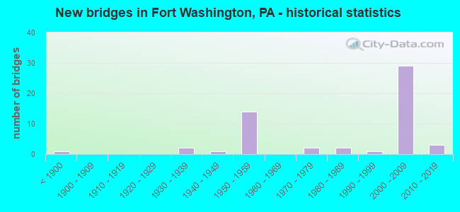
- New bridges - historical statistics
- 1Before 1900
- 21930-1939
- 11940-1949
- 141950-1959
- 21970-1979
- 21980-1989
- 11990-1999
- 292000-2009
- 32010-2019
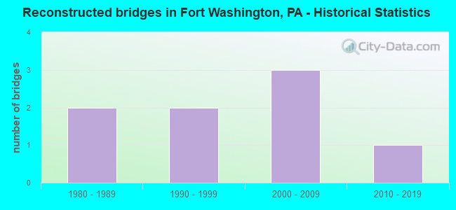
- Reconstructed bridges - Historical Statistics
- 21980-1989
- 21990-1999
- 32000-2009
- 12010-2019
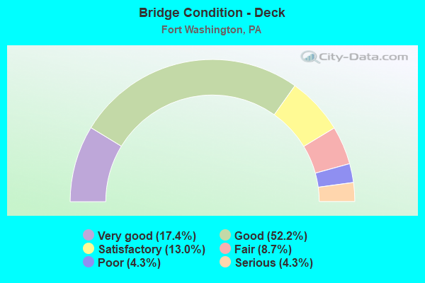
- Bridge Condition - Deck
- 17.4%Very good
- 52.2%Good
- 13.0%Satisfactory
- 8.7%Fair
- 4.3%Poor
- 4.3%Serious
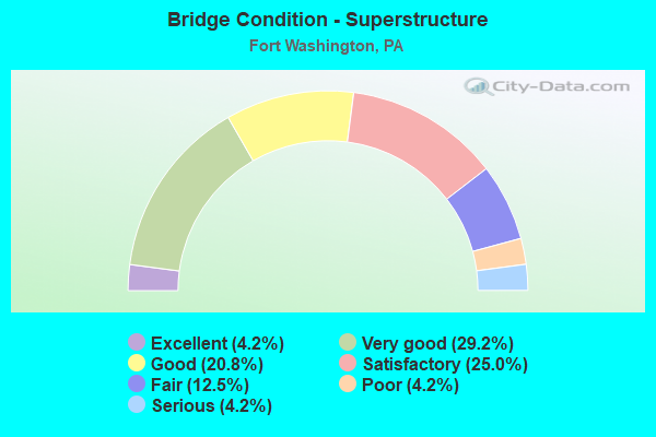
- Bridge Condition - Superstructure
- 4.2%Excellent
- 29.2%Very good
- 20.8%Good
- 25.0%Satisfactory
- 12.5%Fair
- 4.2%Poor
- 4.2%Serious
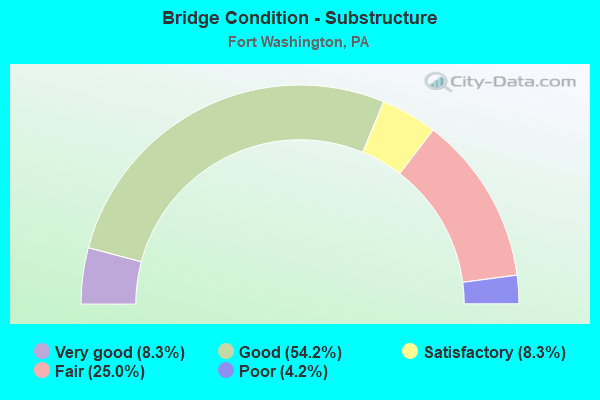
- Bridge Condition - Substructure
- 8.3%Very good
- 54.2%Good
- 8.3%Satisfactory
- 25.0%Fair
- 4.2%Poor
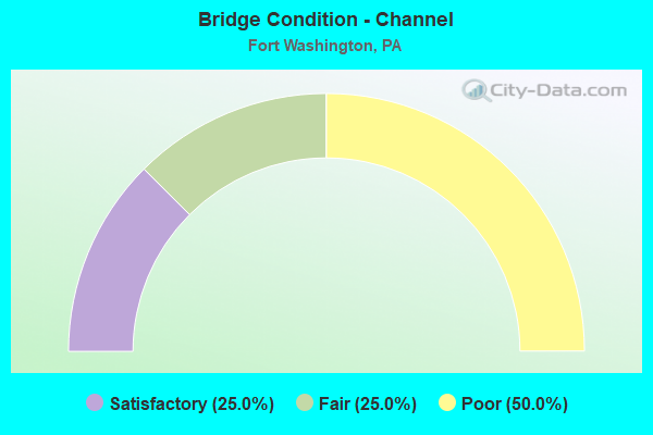
- Bridge Condition - Channel
- 25.0%Satisfactory
- 25.0%Fair
- 50.0%Poor
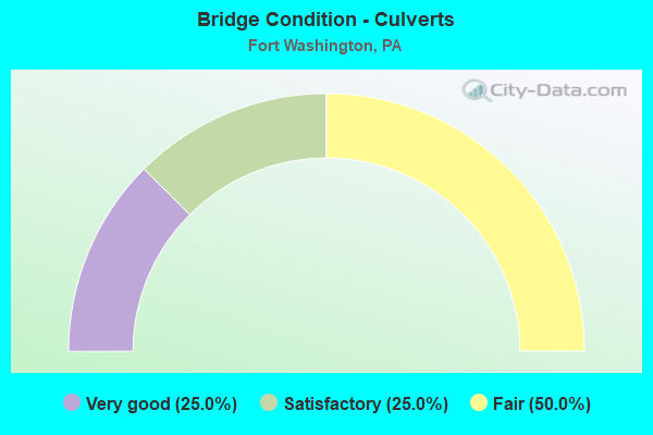
- Bridge Condition - Culverts
- 25.0%Very good
- 25.0%Satisfactory
- 50.0%Fair
Find on map >> Show street view
Structure Number: 27316, Location: U. DUBLIN TWP 31F3/3258D8 (Lat: 40.142831, Lng: -75.167700), Route carried "on" structure: State highway 152, Year Built: 1946, Year Reconstructed: 2001, Status: Open, Structure Length: 1.04m (3.41ft), Average Daily Traffic: 12,298 (year 2021), Truck Traffic: 7%, Average Future Daily Traffic: 18,469 (year 2035), Design Load: HS 25 or greater, Features Intersected: BRANCH SANDY RUN, Facility Carried by Structure: LIMEKILN PIKE
Minimum Vertical Clearance: 30+ m (98+ ft), Kilometerpoint: 6.511, Lanes on structure: 4, Owner: State Highway Agency, Approaching Roadway Width: 12.2m (40.0ft), Material/Design: Concrete, Design/Construction: Tee Beam, Number Of Spans In Main Unit: 1, Length of Maximum Span: 9.8m (32.2ft), Curb or Sidewalk Widths: Left: 1.4m (4.6ft), Right: 1.4m (4.6ft), Curb-To-Curb Width: 15.0m (49.2ft), Out-to-Out Width: 18.6m (61.0ft)
Condition: Deck: Good, Superstructure: Satisfactory, Substructure: Satisfactory, Channel: Satisfactory, Operating Rating: 59.0 metric tons, Method Used To Determine Operating Rating: Load Factor (LF), Inventory Rating: 35.4 metric tons, Method Used To Determine Inventory Rating: Load Factor (LF), Structural Evaluation: Equal to present minimum criteria, Deck Geometry: High priority of replacement, Waterway Adequacy: Equal to present minimum criteria, Approach Roadway Alignment: Equal to present desirable criteria, Length Of Structure Improvement: 1.60m (5.25ft), Designated Inspection Frequency: Every 24 months, Inspection Date: January 2020, Deck Structure Type: Concrete Cast-file-Place, Wearing Surface/Protective System: Wearing Surface: Bituminous
Find on map >> Show street view
Structure Number: 27371, Location: FORT WASHINGTON 30K06 (Lat: 40.125469, Lng: -75.203800), Route carried "on" structure: State highway 309, Year Built: 1958, Year Reconstructed: 2006, Status: Open, Structure Length: 1.34m (4.40ft), Average Daily Traffic: 48,002 (year 2022), Truck Traffic: 3%, Average Future Daily Traffic: 60,532 (year 2032), Design Load: HS 20, Features Intersected: SANDY RUN / 3257-H10
Minimum Vertical Clearance: 30+ m (98+ ft), Kilometerpoint: 9.242, Lanes on structure: 4, Base Highway Network: Yes, Owner: State Highway Agency, Approaching Roadway Width: 21.9m (71.9ft), Skew: 32 degrees, Material/Design: Concrete, Design/Construction: Culvert, Number Of Spans In Main Unit: 1, Length of Maximum Span: 13.4m (44.0ft)
Condition: Channel: Poor, Culverts: Satisfactory, Operating Rating: 67.1 metric tons, Method Used To Determine Operating Rating: Field evaluation and documented engineering judgment, Inventory Rating: 39.9 metric tons, Method Used To Determine Inventory Rating: Field evaluation and documented engineering judgment, Structural Evaluation: Equal to present minimum criteria, Waterway Adequacy: Superior to present desirable criteria, Approach Roadway Alignment: Equal to present desirable criteria, Length Of Structure Improvement: 2.20m (7.22ft), Designated Inspection Frequency: Every 24 months, Inspection Date: August 2021
Find on map >> Show street view
Structure Number: 27372, Location: FORT WASHINGTON 30K06 (Lat: 40.125917, Lng: -75.203517), Route carried "on" structure: State highway 309, Year Built: 1958, Year Reconstructed: 2006, Status: Open, Structure Length: 4.82m (15.81ft), Average Daily Traffic: 48,002 (year 2022), Truck Traffic: 3%, Average Future Daily Traffic: 60,532 (year 2032), Design Load: HS 25 or greater, Features Intersected: CAMP HILL ROAD
Minimum Vertical Clearance: 30+ m (98+ ft), Kilometerpoint: 9.242, Lanes on structure: 2, Lanes under structure: 2, Base Highway Network: Yes, Owner: State Highway Agency, Approaching Roadway Width: 27.4m (89.9ft), Skew: 32 degrees, Material/Design: Steel continuous, Design/Construction: Stringer/Multi-beam, Number Of Spans In Main Unit: 3, Length of Maximum Span: 20.7m (67.9ft), Curb or Sidewalk Widths: Left: 0.1m (0.3ft), Right: 0.1m (0.3ft), Curb-To-Curb Width: 27.5m (90.2ft), Out-to-Out Width: 29.2m (95.8ft)
Condition: Deck: Good, Superstructure: Very good, Substructure: Good, Inventory Rating: 60.8 metric tons, Method Used To Determine Inventory Rating: Load Factor (LF), Structural Evaluation: Better than present minimum criteria, Deck Geometry: Superior to present desirable criteria, Underclear: Superior to present desirable criteria, Approach Roadway Alignment: Equal to present desirable criteria, Length Of Structure Improvement: 5.50m (18.04ft), Designated Inspection Frequency: Every 24 months, Inspection Date: September 2020, Deck Structure Type: Concrete Cast-file-Place, Wearing Surface/Protective System: Wearing Surface: Monolithic Concrete
Find on map >> Show street view
Structure Number: 27383, Location: UPPER DUBLIN 30K2/3257H7 (Lat: 40.148239, Lng: -75.204131), Route carried "on" structure: State highway 309, Year Built: 1958, Year Reconstructed: 2006, Status: Open, Structure Length: 4.57m (14.99ft), Average Daily Traffic: 46,647 (year 2022), Truck Traffic: 5%, Average Future Daily Traffic: 56,827 (year 2032), Design Load: HS 25 or greater, Features Intersected: HIGHLAND AVENUE
Minimum Vertical Clearance: 30+ m (98+ ft), Kilometerpoint: 12.073, Lanes on structure: 2, Lanes under structure: 2, Base Highway Network: Yes, Owner: State Highway Agency, Approaching Roadway Width: 21.9m (71.9ft), Skew: 31 degrees, Material/Design: Steel continuous, Design/Construction: Stringer/Multi-beam, Number Of Spans In Main Unit: 3, Length of Maximum Span: 22.6m (74.1ft), Curb or Sidewalk Widths: Left: 0.1m (0.3ft), Right: 0.1m (0.3ft), Curb-To-Curb Width: 20.7m (67.9ft), Out-to-Out Width: 28.2m (92.5ft)
Condition: Deck: Good, Superstructure: Very good, Substructure: Good, Inventory Rating: 64.4 metric tons, Method Used To Determine Inventory Rating: Load Factor (LF), Structural Evaluation: Better than present minimum criteria, Deck Geometry: Superior to present desirable criteria, Underclear: Somewhat better than minimum adequacy, Approach Roadway Alignment: Equal to present desirable criteria, Length Of Structure Improvement: 5.50m (18.04ft), Designated Inspection Frequency: Every 24 months, Inspection Date: August 2020, Bridge Improvement Cost: $57,000, Roadway Improvement Cost: $167,000, Total Project Cost: $766,000, Deck Structure Type: Concrete Cast-file-Place, Wearing Surface/Protective System: Wearing Surface: Monolithic Concrete, Deck Protection: Epoxy Coated Reinforcing
Find on map >> Show street view
Structure Number: 27384, Location: UPPER DUBLIN 31A1/3257H6 (Lat: 40.153417, Lng: -75.201878), Route carried "on" structure: State highway 309, Year Built: 1958, Year Reconstructed: 2010, Status: Open, Structure Length: 4.27m (14.01ft), Average Daily Traffic: 46,647 (year 2022), Truck Traffic: 5%, Average Future Daily Traffic: 56,827 (year 2032), Design Load: HS 25 or greater, Features Intersected: LOCH ALSH AVENUE
Minimum Vertical Clearance: 30+ m (98+ ft), Kilometerpoint: 13.057, Lanes on structure: 2, Lanes under structure: 2, Base Highway Network: Yes, Owner: State Highway Agency, Approaching Roadway Width: 27.1m (88.9ft), Skew: 31 degrees, Material/Design: Steel continuous, Design/Construction: Stringer/Multi-beam, Number Of Spans In Main Unit: 3, Length of Maximum Span: 21.0m (68.9ft), Curb or Sidewalk Widths: Left: 0.2m (0.7ft), Right: 0.2m (0.7ft), Curb-To-Curb Width: 27.3m (89.6ft), Out-to-Out Width: 28.3m (92.8ft)
Condition: Deck: Good, Superstructure: Very good, Substructure: Good, Inventory Rating: 65.3 metric tons, Method Used To Determine Inventory Rating: Load Factor (LF), Structural Evaluation: Better than present minimum criteria, Deck Geometry: Superior to present desirable criteria, Underclear: Somewhat better than minimum adequacy, Approach Roadway Alignment: Equal to present desirable criteria, Length Of Structure Improvement: 5.10m (16.73ft), Designated Inspection Frequency: Every 24 months, Inspection Date: August 2020, Bridge Improvement Cost: $26,000, Roadway Improvement Cost: $77,000, Total Project Cost: $352,000, Deck Structure Type: Concrete Cast-file-Place, Wearing Surface/Protective System: Wearing Surface: Monolithic Concrete, Deck Protection: Epoxy Coated Reinforcing
Find on map >> Show street view
Structure Number: 27588, Location: FORT WASHING 30J4/3257F8 (Lat: 40.139389, Lng: -75.216792), Route carried "on" structure: State highway , Year Built: 1841, Year Reconstructed: 1996, Status: Open, Structure Length: 2.87m (9.42ft), Average Daily Traffic: 7,768 (year 2022), Truck Traffic: 3%, Average Future Daily Traffic: 11,755 (year 2032), Design Load: H 15, Features Intersected: WISSAHICKON CREEK, Facility Carried by Structure: MORRIS ROAD
Minimum Vertical Clearance: 30+ m (98+ ft), Kilometerpoint: 0.721, Lanes on structure: 2, Owner: State Highway Agency, Approaching Roadway Width: 9.4m (30.8ft), Material/Design: Masonry, Design/Construction: Arch - Deck, Number Of Spans In Main Unit: 3, Length of Maximum Span: 8.5m (27.9ft), Curb-To-Curb Width: 7.2m (23.6ft), Out-to-Out Width: 7.6m (24.9ft)
Condition: Superstructure: Satisfactory, Substructure: Fair, Channel: Poor, Operating Rating: 61.7 metric tons, Method Used To Determine Operating Rating: Field evaluation and documented engineering judgment, Inventory Rating: 30.8 metric tons, Method Used To Determine Inventory Rating: Field evaluation and documented engineering judgment, Structural Evaluation: Somewhat better than minimum adequacy, Deck Geometry: High priority of replacement, Waterway Adequacy: Equal to present minimum criteria, Approach Roadway Alignment: Equal to present desirable criteria, Length Of Structure Improvement: 4.10m (13.45ft), Designated Inspection Frequency: Every 24 months, Inspection Date: April 2021, Bridge Improvement Cost: $84,000, Roadway Improvement Cost: $249,000, Total Project Cost: $1,139,000
Find on map >> Show street view
Structure Number: 27619, Location: N.OF PA.TURNPIKE 30J05 (Lat: 40.133431, Lng: -75.214025), Route carried "on" structure: State highway , Year Built: 1931, Status: Posted for load, Structure Length: 2.26m (7.41ft), Average Daily Traffic: 7,485 (year 2021), Truck Traffic: 6%, Average Future Daily Traffic: 14,383 (year 2032), Design Load: H 15, Features Intersected: SANDY RUN CREEK, Facility Carried by Structure: BETHLEHEM PIKE
Minimum Vertical Clearance: 30+ m (98+ ft), Kilometerpoint: 4.455, Lanes on structure: 2, Owner: State Highway Agency, Approaching Roadway Width: 15.2m (49.9ft), Skew: 22 degrees, Material/Design: Concrete, Design/Construction: Tee Beam, Number Of Spans In Main Unit: 2, Length of Maximum Span: 11.0m (36.1ft), Curb or Sidewalk Widths: Left: 1.5m (4.9ft), Right: 1.5m (4.9ft), Curb-To-Curb Width: 12.3m (40.4ft), Out-to-Out Width: 16.8m (55.1ft)
Condition: Deck: Poor, Superstructure: Poor, Substructure: Fair, Channel: Poor, Operating Rating: 48.1 metric tons, Method Used To Determine Operating Rating: Load Factor (LF), Inventory Rating: 28.1 metric tons, Method Used To Determine Inventory Rating: Load Factor (LF), Structural Evaluation: Meets minimum limits, Deck Geometry: Somewhat better than minimum adequacy, Waterway Adequacy: Equal to present minimum criteria, Approach Roadway Alignment: Better than present minimum criteria, Length Of Structure Improvement: 2.90m (9.51ft), Designated Inspection Frequency: Every 24 months, Other Special Inspection Frequency: Every 12 months, Inspection Date: August 2020, Other Special Inspection Date: August 2021, Bridge Improvement Cost: $67,000, Roadway Improvement Cost: $197,000, Total Project Cost: $903,000, Deck Structure Type: Concrete Cast-file-Place, Wearing Surface/Protective System: Wearing Surface: Bituminous
Find on map >> Show street view
Structure Number: 27646, Location: FORT WASHINGTON 30K06 (Lat: 40.126297, Lng: -75.203906), Route carried "on" structure: State highway , Year Built: 1930, Status: Open, Structure Length: 1.40m (4.59ft), Average Daily Traffic: 5,308 (year 2020), Truck Traffic: 4%, Average Future Daily Traffic: 8,338 (year 2032), Design Load: H 15, Features Intersected: SANDY RUN, Facility Carried by Structure: CAMP HILL ROAD
Minimum Vertical Clearance: 30+ m (98+ ft), Kilometerpoint: 1.357, Lanes on structure: 2, Owner: State Highway Agency, Approaching Roadway Width: 7.3m (24.0ft), Skew: 4 degrees, Material/Design: Concrete continuous, Design/Construction: Stringer/Multi-beam, Number Of Spans In Main Unit: 2, Length of Maximum Span: 7.0m (23.0ft), Curb or Sidewalk Widths: Left: 1.5m (4.9ft), Right: 1.5m (4.9ft), Curb-To-Curb Width: 7.3m (24.0ft), Out-to-Out Width: 11.0m (36.1ft)
Condition: Deck: Fair, Superstructure: Fair, Substructure: Fair, Channel: Poor, Operating Rating: 86.2 metric tons, Method Used To Determine Operating Rating: Load Factor (LF), Inventory Rating: 51.7 metric tons, Method Used To Determine Inventory Rating: Load Factor (LF), Structural Evaluation: Somewhat better than minimum adequacy, Deck Geometry: High priority of replacement, Waterway Adequacy: Better than present minimum criteria, Approach Roadway Alignment: Meets minimum limits, Length Of Structure Improvement: 2.00m (6.56ft), Designated Inspection Frequency: Every 24 months, Inspection Date: October 2020, Bridge Improvement Cost: $5,000, Roadway Improvement Cost: $15,000, Total Project Cost: $70,000, Deck Structure Type: Concrete Cast-file-Place, Wearing Surface/Protective System: Wearing Surface: Bituminous
Find on map >> Show street view
Structure Number: 28048, Location: 1 M. SW Rte 2017 3258-A9 (Lat: 40.135050, Lng: -75.185719), Route carried "on" structure: City street , Year Built: 1970, Status: Open, Structure Length: 1.68m (5.51ft), Average Daily Traffic: 3,000 (year 2018), Truck Traffic: 1%, Average Future Daily Traffic: 4,200 (year 2038), Features Intersected: PINE RUN, Facility Carried by Structure: CAMP HILL ROAD
Minimum Vertical Clearance: 30+ m (98+ ft), Kilometerpoint: 0.000, Lanes on structure: 2, Owner: Town or Township Highway Agency, Approaching Roadway Width: 6.4m (21.0ft), Material/Design: Concrete continuous, Design/Construction: Tee Beam, Number Of Spans In Main Unit: 2, Length of Maximum Span: 8.2m (26.9ft), Curb or Sidewalk Widths: Left: 0.2m (0.7ft), Right: 1.2m (3.9ft), Curb-To-Curb Width: 7.4m (24.3ft), Out-to-Out Width: 9.3m (30.5ft)
Condition: Deck: Satisfactory, Superstructure: Satisfactory, Substructure: Satisfactory, Channel: Poor, Operating Rating: 75.3 metric tons, Method Used To Determine Operating Rating: Field evaluation and documented engineering judgment, Inventory Rating: 45.4 metric tons, Method Used To Determine Inventory Rating: Field evaluation and documented engineering judgment, Structural Evaluation: Equal to present minimum criteria, Deck Geometry: High priority of replacement, Waterway Adequacy: Equal to present desirable criteria, Approach Roadway Alignment: Equal to present desirable criteria, Length Of Structure Improvement: 2.10m (6.89ft), Designated Inspection Frequency: Every 24 months, Inspection Date: Febuary 2021, Bridge Improvement Cost: $10,000, Roadway Improvement Cost: $31,000, Total Project Cost: $140,000, Deck Structure Type: Concrete Cast-file-Place, Wearing Surface/Protective System: Wearing Surface: Bituminous
Find on map >> Show street view
Structure Number: 28182, Location: NEAR FORT WASHINGTON (Lat: 40.130769, Lng: -75.203575), Route carried "on" structure: Interstate 276, Year Built: 1954, Year Reconstructed: 1987, Status: Open, Structure Length: 5.15m (16.90ft), Average Daily Traffic: 74,921 (year 2001), Truck Traffic: 14%, Average Future Daily Traffic: 103,041 (year 2030), Design Load: HS 20, Features Intersected: SEPTA RR.
Minimum Vertical Clearance: 30+ m (98+ ft), Kilometerpoint: 0.000, Lanes on structure: 6, Base Highway Network: Yes, Toll: On toll road, Owner: State Toll Authority, Approaching Roadway Width: 32.3m (106.0ft), Skew: 32 degrees, Material/Design: Steel continuous, Design/Construction: Stringer/Multi-beam, Number Of Spans In Main Unit: 3, Length of Maximum Span: 19.5m (64.0ft), Curb or Sidewalk Widths: Left: 0.2m (0.7ft), Right: 0.2m (0.7ft), Curb-To-Curb Width: 31.6m (103.7ft), Out-to-Out Width: 33.5m (109.9ft)
Condition: Deck: Good, Superstructure: Satisfactory, Substructure: Fair, Operating Rating: 59.9 metric tons, Method Used To Determine Operating Rating: Load Factor (LF), Inventory Rating: 35.4 metric tons, Method Used To Determine Inventory Rating: Load Factor (LF), Structural Evaluation: Somewhat better than minimum adequacy, Deck Geometry: Superior to present desirable criteria, Underclear: High priority of corrective action, Approach Roadway Alignment: Equal to present desirable criteria, Length Of Structure Improvement: 6.20m (20.34ft), Designated Inspection Frequency: Every 24 months, Inspection Date: July 2021, Deck Structure Type: Concrete Cast-file-Place, Wearing Surface/Protective System: Wearing Surface: Latex Concrete, Deck Protection: Epoxy Coated Reinforcing
Find on map >> Show street view
Structure Number: 28183, Location: NEAR FORT WASHINGTON (Lat: 40.130764, Lng: -75.203592), Route carried "on" structure: Interstate 276, Year Built: 1954, Status: Open, Structure Length: 1.65m (5.41ft), Average Daily Traffic: 74,921 (year 2001), Truck Traffic: 14%, Average Future Daily Traffic: 103,041 (year 2030), Design Load: HS 20, Features Intersected: SANDY RUN
Minimum Vertical Clearance: 30+ m (98+ ft), Kilometerpoint: 0.000, Lanes on structure: 6, Base Highway Network: Yes, Toll: On toll road, Owner: State Toll Authority, Approaching Roadway Width: 32.6m (107.0ft), Skew: 30 degrees, Material/Design: Concrete, Design/Construction: Culvert, Number Of Spans In Main Unit: 1, Length of Maximum Span: 14.3m (46.9ft), Curb or Sidewalk Widths: Left: 0.2m (0.7ft), Right: 0.2m (0.7ft)
Condition: Channel: Fair, Culverts: Fair, Operating Rating: 89.8 metric tons, Method Used To Determine Operating Rating: Load Factor (LF), Inventory Rating: 89.8 metric tons, Method Used To Determine Inventory Rating: Load Factor (LF), Structural Evaluation: Somewhat better than minimum adequacy, Waterway Adequacy: Superior to present desirable criteria, Approach Roadway Alignment: Equal to present desirable criteria, Length Of Structure Improvement: 2.30m (7.55ft), Designated Inspection Frequency: Every 24 months, Inspection Date: May 2021
Find on map >> Show street view
Structure Number: 28184, Location: WEST OF FT WASHINGTONINTG (Lat: 40.131103, Lng: -75.201456), Route carried "on" structure: Interstate 276, Year Built: 2000, Status: Open, Structure Length: 8.72m (28.61ft), Average Daily Traffic: 74,921 (year 2001), Truck Traffic: 14%, Average Future Daily Traffic: 103,041 (year 2030), Design Load: HS 20, Features Intersected: US-309
Minimum Vertical Clearance: 30+ m (98+ ft), Kilometerpoint: 0.000, Lanes on structure: 7, Lanes under structure: 10, Base Highway Network: Yes, Toll: On toll road, Owner: State Toll Authority, Approaching Roadway Width: 35.4m (116.1ft), Skew: 32 degrees, Material/Design: Steel continuous, Design/Construction: Stringer/Multi-beam, Number Of Spans In Main Unit: 3, Length of Maximum Span: 35.4m (116.1ft), Curb or Sidewalk Widths: Left: 0.2m (0.7ft), Right: 0.2m (0.7ft), Curb-To-Curb Width: 35.1m (115.2ft), Out-to-Out Width: 36.9m (121.1ft)
Condition: Deck: Very good, Superstructure: Good, Substructure: Good, Inventory Rating: 62.6 metric tons, Method Used To Determine Inventory Rating: Load Factor (LF), Structural Evaluation: Better than present minimum criteria, Deck Geometry: Superior to present desirable criteria, Underclear: Somewhat better than minimum adequacy, Approach Roadway Alignment: Equal to present desirable criteria, Length Of Structure Improvement: 5.80m (19.03ft), Designated Inspection Frequency: Every 48 months, Inspection Date: May 2018, Bridge Improvement Cost: $46,000, Roadway Improvement Cost: $135,000, Total Project Cost: $618,000, Deck Structure Type: Concrete Cast-file-Place, Wearing Surface/Protective System: Wearing Surface: Monolithic Concrete, Deck Protection: Epoxy Coated Reinforcing
Find on map >> Show street view
Structure Number: 28186, Location: FORT WASHINGTON INTERCHG (Lat: 40.133333, Lng: -75.193333), Route carried "on" structure: Ramp Other road 276, Year Built: 1983, Status: Open, Structure Length: 6.28m (20.60ft), Average Daily Traffic: 34,335 (year 1993), Truck Traffic: 6%, Average Future Daily Traffic: 53,385 (year 2030), Design Load: HS 20, Features Intersected: PA TPK (I-276), Facility Carried by Structure: PA TPK (RAMP AB)
Minimum Vertical Clearance: 30+ m (98+ ft), Kilometerpoint: 0.000, Lanes on structure: 3, Lanes under structure: 7, Base Highway Network: Yes, Toll: On toll road, Owner: State Toll Authority, Approaching Roadway Width: 15.8m (51.8ft), Skew: 30 degrees, Material/Design: Steel, Design/Construction: Stringer/Multi-beam, Number Of Spans In Main Unit: 1, Number Of Approach Spans: 2, Length of Maximum Span: 42.1m (138.1ft), Curb or Sidewalk Widths: Left: 0.2m (0.7ft), Right: 0.2m (0.7ft), Curb-To-Curb Width: 17.6m (57.7ft), Out-to-Out Width: 19.1m (62.7ft)
Condition: Deck: Satisfactory, Superstructure: Good, Substructure: Good, Operating Rating: 97.1 metric tons, Method Used To Determine Operating Rating: Load Factor (LF), Inventory Rating: 58.1 metric tons, Method Used To Determine Inventory Rating: Load Factor (LF), Structural Evaluation: Better than present minimum criteria, Deck Geometry: Superior to present desirable criteria, Underclear: Meets minimum limits, Approach Roadway Alignment: Equal to present minimum criteria, Length Of Structure Improvement: 7.20m (23.62ft), Designated Inspection Frequency: Every 48 months, Inspection Date: May 2018, Deck Structure Type: Concrete Cast-file-Place, Wearing Surface/Protective System: Wearing Surface: Monolithic Concrete
Find on map >> Show street view
Structure Number: 28187, Location: EAST OF FT WASH INTERCHG. (Lat: 40.134200, Lng: -75.185872), Route carried "on" structure: City street , Year Built: 1954, Status: Open, Structure Length: 3.54m (11.61ft), Average Daily Traffic: 200 (year 1992), Truck Traffic: 2%, Average Future Daily Traffic: 315 (year 2030), Design Load: HS 20, Features Intersected: PA TPK (I-276), Facility Carried by Structure: T-331
Minimum Vertical Clearance: 30+ m (98+ ft), Kilometerpoint: 0.000, Lanes on structure: 2, Lanes under structure: 6, Owner: State Toll Authority, Approaching Roadway Width: 6.1m (20.0ft), Skew: 3 degrees, Material/Design: Steel, Design/Construction: Girder and Floorbeam System, Number Of Spans In Main Unit: 1, Length of Maximum Span: 33.2m (108.9ft), Curb or Sidewalk Widths: Left: 0.2m (0.7ft), Right: 1.2m (3.9ft), Curb-To-Curb Width: 7.3m (24.0ft), Out-to-Out Width: 9.7m (31.8ft)
Condition: Deck: Fair, Superstructure: Fair, Substructure: Fair, Operating Rating: 55.3 metric tons, Method Used To Determine Operating Rating: Load Factor (LF), Inventory Rating: 32.7 metric tons, Method Used To Determine Inventory Rating: Load Factor (LF), Structural Evaluation: Somewhat better than minimum adequacy, Deck Geometry: Somewhat better than minimum adequacy, Underclear: High priority of corrective action, Approach Roadway Alignment: Somewhat better than minimum adequacy, Length Of Structure Improvement: 4.40m (14.44ft), Designated Inspection Frequency: Every 24 months, Critical Feature Inspection Frequency: Every 24 months, Inspection Date: July 2020, Critical Feature Inspection Date: July 2020, Bridge Improvement Cost: $45,000, Roadway Improvement Cost: $134,000, Total Project Cost: $612,000, Deck Structure Type: Concrete Cast-file-Place, Wearing Surface/Protective System: Wearing Surface: Bituminous
Find on map >> Show street view
Structure Number: 28188, Location: NEAR DRESHER (Lat: 40.140000, Lng: -75.166667), Route carried "on" structure: Interstate 276, Year Built: 1954, Year Reconstructed: 1986, Status: Open, Structure Length: 8.23m (27.00ft), Average Daily Traffic: 97,693 (year 2001), Truck Traffic: 13%, Average Future Daily Traffic: 124,693 (year 2030), Design Load: HS 20, Features Intersected: SR 2017
Minimum Vertical Clearance: 30+ m (98+ ft), Kilometerpoint: 0.000, Lanes on structure: 6, Lanes under structure: 4, Base Highway Network: Yes, Toll: On toll road, Owner: State Toll Authority, Approaching Roadway Width: 32.3m (106.0ft), Skew: 35 degrees, Material/Design: Steel continuous, Design/Construction: Stringer/Multi-beam, Number Of Spans In Main Unit: 5, Length of Maximum Span: 23.2m (76.1ft), Curb or Sidewalk Widths: Left: 0.2m (0.7ft), Right: 0.2m (0.7ft), Curb-To-Curb Width: 31.4m (103.0ft), Out-to-Out Width: 33.1m (108.6ft)
Condition: Deck: Satisfactory, Superstructure: Satisfactory, Substructure: Fair, Operating Rating: 52.6 metric tons, Method Used To Determine Operating Rating: Load Factor (LF), Inventory Rating: 31.8 metric tons, Method Used To Determine Inventory Rating: Load Factor (LF), Structural Evaluation: Somewhat better than minimum adequacy, Deck Geometry: Superior to present desirable criteria, Underclear: High priority of corrective action, Approach Roadway Alignment: Equal to present desirable criteria, Length Of Structure Improvement: 9.20m (30.18ft), Designated Inspection Frequency: Every 24 months, Inspection Date: June 2021, Bridge Improvement Cost: $72,000, Roadway Improvement Cost: $212,000, Total Project Cost: $971,000, Deck Structure Type: Concrete Cast-file-Place, Wearing Surface/Protective System: Wearing Surface: Latex Concrete
Find on map >> Show street view
Structure Number: 41701, Location: .5MI N.PA.TPK 30K03 (Lat: 40.142222, Lng: -75.202778), Route carried "on" structure: State highway , Year Built: 2002, Status: Open, Structure Length: 4.11m (13.48ft), Average Daily Traffic: 545 (year 2022), Truck Traffic: 8%, Average Future Daily Traffic: 4,590 (year 2032), Design Load: HS 25 or greater, Features Intersected: T.R.309 BY-PASS, Facility Carried by Structure: SUMMIT AVENUE
Minimum Vertical Clearance: 30+ m (98+ ft), Kilometerpoint: 0.000, Lanes on structure: 2, Lanes under structure: 5, Owner: State Highway Agency, Approaching Roadway Width: 9.8m (32.2ft), Skew: 2 degrees, Material/Design: Steel, Design/Construction: Stringer/Multi-beam, Number Of Spans In Main Unit: 1, Length of Maximum Span: 39.3m (128.9ft), Curb or Sidewalk Widths: Left: 1.5m (4.9ft), Right: 1.5m (4.9ft), Curb-To-Curb Width: 9.6m (31.5ft), Out-to-Out Width: 13.3m (43.6ft)
Condition: Deck: Very good, Superstructure: Good, Substructure: Good, Operating Rating: 82.6 metric tons, Method Used To Determine Operating Rating: Load Factor (LF), Inventory Rating: 49.9 metric tons, Method Used To Determine Inventory Rating: Load Factor (LF), Structural Evaluation: Better than present minimum criteria, Deck Geometry: Equal to present minimum criteria, Underclear: Meets minimum limits, Approach Roadway Alignment: Equal to present desirable criteria, Length Of Structure Improvement: 5.00m (16.40ft), Designated Inspection Frequency: Every 24 months, Inspection Date: September 2020, Deck Structure Type: Concrete Cast-file-Place, Wearing Surface/Protective System: Wearing Surface: Monolithic Concrete, Deck Protection: Epoxy Coated Reinforcing
Find on map >> Show street view
Structure Number: 44043, Location: UPPER DUBLIN TWP, 30K03 (Lat: 40.144617, Lng: -75.204408), Route carried "on" structure: State highway , Year Built: 2006, Status: Open, Structure Length: 4.91m (16.11ft), Average Daily Traffic: 4,035 (year 2022), Truck Traffic: 5%, Average Future Daily Traffic: 4,996 (year 2032), Design Load: HS 25 or greater, Features Intersected: PA 309 BY-PASS/ 3257-H7, Facility Carried by Structure: FORT WASHINGTON AV
Minimum Vertical Clearance: 30+ m (98+ ft), Kilometerpoint: 0.774, Lanes on structure: 2, Lanes under structure: 6, Owner: State Highway Agency, Approaching Roadway Width: 11.9m (39.0ft), Skew: 3 degrees, Material/Design: Steel continuous, Design/Construction: Stringer/Multi-beam, Number Of Spans In Main Unit: 2, Length of Maximum Span: 25.9m (85.0ft), Curb or Sidewalk Widths: Left: 1.7m (5.6ft), Right: 1.7m (5.6ft), Curb-To-Curb Width: 12.0m (39.4ft), Out-to-Out Width: 16.1m (52.8ft)
Condition: Deck: Good, Superstructure: Good, Substructure: Good, Operating Rating: 89.8 metric tons, Method Used To Determine Operating Rating: Load Factor (LF), Inventory Rating: 54.4 metric tons, Method Used To Determine Inventory Rating: Load Factor (LF), Structural Evaluation: Better than present minimum criteria, Deck Geometry: Somewhat better than minimum adequacy, Underclear: Meets minimum limits, Approach Roadway Alignment: Equal to present desirable criteria, Designated Inspection Frequency: Every 24 months, Inspection Date: June 2021, Deck Structure Type: Concrete Cast-file-Place, Wearing Surface/Protective System: Wearing Surface: Monolithic Concrete, Deck Protection: Epoxy Coated Reinforcing
Find on map >> Show street view
Structure Number: 44065, Location: FORT WASH. 30K4/3257H8 (Lat: 40.142250, Lng: -75.202992), Route carried "on" structure: State highway , Year Built: 2006, Status: Open, Structure Length: 3.90m (12.80ft), Average Daily Traffic: 416 (year 2022), Truck Traffic: 8%, Average Future Daily Traffic: 533 (year 2032), Design Load: HS 25 or greater, Features Intersected: PA 309 EXPRESSWAY, Facility Carried by Structure: MADISON AVENUE
Minimum Vertical Clearance: 30.18m (99.02ft), Kilometerpoint: 0.000, Lanes on structure: 2, Lanes under structure: 6, Owner: State Highway Agency, Approaching Roadway Width: 12.2m (40.0ft), Skew: 2 degrees, Material/Design: Steel, Design/Construction: Stringer/Multi-beam, Number Of Spans In Main Unit: 1, Length of Maximum Span: 37.2m (122.0ft), Curb or Sidewalk Widths: Left: 1.5m (4.9ft), Right: 0.2m (0.7ft), Curb-To-Curb Width: 12.2m (40.0ft), Out-to-Out Width: 13.1m (43.0ft)
Condition: Deck: Good, Superstructure: Very good, Substructure: Good, Operating Rating: 74.4 metric tons, Method Used To Determine Operating Rating: Load Factor (LF), Inventory Rating: 44.5 metric tons, Method Used To Determine Inventory Rating: Load Factor (LF), Structural Evaluation: Better than present minimum criteria, Deck Geometry: Equal to present desirable criteria, Underclear: Better than present minimum criteria, Approach Roadway Alignment: Equal to present desirable criteria, Designated Inspection Frequency: Every 24 months, Inspection Date: July 2020, Deck Structure Type: Concrete Cast-file-Place, Wearing Surface/Protective System: Wearing Surface: Monolithic Concrete, Deck Protection: Epoxy Coated Reinforcing
Find on map >> Show street view
Structure Number: 45251, Location: FORT WASH. 31A6/3257H10 (Lat: 40.127978, Lng: -75.202428), Route carried "on" structure: State highway 309, Year Built: 2008, Status: Open, Structure Length: 8.38m (27.49ft), Average Daily Traffic: 48,301 (year 2022), Truck Traffic: 3%, Average Future Daily Traffic: 60,908 (year 2032), Design Load: HL 93, Features Intersected: PENNSYLVANIA AVE./SEPTA
Minimum Vertical Clearance: 30+ m (98+ ft), Kilometerpoint: 10.120, Lanes on structure: 3, Lanes under structure: 2, Base Highway Network: Yes, Owner: State Highway Agency, Approaching Roadway Width: 20.7m (67.9ft), Skew: 35 degrees, Material/Design: Steel continuous, Design/Construction: Stringer/Multi-beam, Number Of Spans In Main Unit: 3, Length of Maximum Span: 31.4m (103.0ft), Curb or Sidewalk Widths: Left: 0.2m (0.7ft), Right: 0.2m (0.7ft), Curb-To-Curb Width: 20.7m (67.9ft), Out-to-Out Width: 38.6m (126.6ft)
Condition: Deck: Good, Superstructure: Satisfactory, Substructure: Good, Operating Rating: 86.2 metric tons, Method Used To Determine Operating Rating: Load Factor (LF), Inventory Rating: 51.7 metric tons, Method Used To Determine Inventory Rating: Load Factor (LF), Structural Evaluation: Equal to present minimum criteria, Deck Geometry: Superior to present desirable criteria, Underclear: High priority of corrective action, Approach Roadway Alignment: Better than present minimum criteria, Designated Inspection Frequency: Every 24 months, Inspection Date: January 2021, Deck Structure Type: Concrete Cast-file-Place, Wearing Surface/Protective System: Wearing Surface: Monolithic Concrete, Deck Protection: Epoxy Coated Reinforcing
Find on map >> Show street view
Structure Number: 45303, Location: FORT WASHINGTON 3257H09 (Lat: 40.137078, Lng: -75.201281), Route carried "on" structure: State highway 309, Year Built: 2008, Status: Open, Structure Length: 7.65m (25.10ft), Average Daily Traffic: 53,627 (year 2022), Truck Traffic: 5%, Average Future Daily Traffic: 67,288 (year 2032), Design Load: HS 25 or greater, Features Intersected: COMMERCE DRIVE
Minimum Vertical Clearance: 30+ m (98+ ft), Kilometerpoint: 11.140, Lanes on structure: 4, Lanes under structure: 4, Base Highway Network: Yes, Owner: State Highway Agency, Approaching Roadway Width: 25.6m (84.0ft), Skew: 33 degrees, Material/Design: Steel continuous, Design/Construction: Stringer/Multi-beam, Number Of Spans In Main Unit: 3, Length of Maximum Span: 32.0m (105.0ft), Curb-To-Curb Width: 25.5m (83.7ft), Out-to-Out Width: 41.9m (137.5ft)
Condition: Deck: Good, Superstructure: Very good, Substructure: Good, Operating Rating: 81.6 metric tons, Method Used To Determine Operating Rating: Load Factor (LF), Inventory Rating: 49.0 metric tons, Method Used To Determine Inventory Rating: Load Factor (LF), Structural Evaluation: Better than present minimum criteria, Deck Geometry: Superior to present desirable criteria, Underclear: Equal to present minimum criteria, Approach Roadway Alignment: Equal to present desirable criteria, Designated Inspection Frequency: Every 24 months, Inspection Date: September 2020, Deck Structure Type: Concrete Cast-file-Place, Wearing Surface/Protective System: Wearing Surface: Monolithic Concrete, Membrane: Other, Deck Protection: Epoxy Coated Reinforcing
Find on map >> Show street view
Structure Number: 45313, Location: FORT WASHINGTON INT. (Lat: 40.133333, Lng: -75.201667), Route carried "on" structure: State highway 309, Year Built: 2008, Status: Open, Structure Length: 3.23m (10.60ft), Average Daily Traffic: 54,125 (year 2022), Truck Traffic: 5%, Average Future Daily Traffic: 67,915 (year 2032), Design Load: HL 93, Features Intersected: PA TURNPIKE RAMP AB
Minimum Vertical Clearance: 30+ m (98+ ft), Kilometerpoint: 10.120, Lanes on structure: 4, Lanes under structure: 5, Base Highway Network: Yes, Owner: State Highway Agency, Approaching Roadway Width: 26.2m (86.0ft), Skew: 31 degrees, Material/Design: Steel, Design/Construction: Stringer/Multi-beam, Number Of Spans In Main Unit: 1, Length of Maximum Span: 31.1m (102.0ft), Curb-To-Curb Width: 26.1m (85.6ft), Out-to-Out Width: 46.5m (152.6ft)
Condition: Deck: Very good, Superstructure: Fair, Substructure: Good, Operating Rating: 99.8 metric tons, Method Used To Determine Operating Rating: Load Factor (LF), Inventory Rating: 59.9 metric tons, Method Used To Determine Inventory Rating: Load Factor (LF), Structural Evaluation: Somewhat better than minimum adequacy, Deck Geometry: Superior to present desirable criteria, Underclear: High priority of corrective action, Approach Roadway Alignment: Equal to present desirable criteria, Designated Inspection Frequency: Every 24 months, Inspection Date: September 2020, Deck Structure Type: Concrete Cast-file-Place, Wearing Surface/Protective System: Wearing Surface: Monolithic Concrete, Membrane: Other, Deck Protection: Epoxy Coated Reinforcing
Find on map >> Show street view
Structure Number: 45334, Location: FORT WASHINGTON INT. (Lat: 40.131211, Lng: -75.201336), Route carried "on" structure: Ramp State highway , Year Built: 2009, Status: Open, Structure Length: 22.07m (72.41ft), Average Daily Traffic: 2,063 (year 2011), Truck Traffic: 7%, Average Future Daily Traffic: 2,588 (year 2030), Design Load: HS 25 or greater, Features Intersected: SR 0309; PA TPK Ramp AB, Facility Carried by Structure: PA TPK (RAMP Q)
Minimum Vertical Clearance: 30+ m (98+ ft), Kilometerpoint: 0.000, Lanes on structure: 1, Lanes under structure: 9, Base Highway Network: Yes, Owner: State Toll Authority, Approaching Roadway Width: 11.3m (37.1ft), Material/Design: Steel continuous, Design/Construction: Stringer/Multi-beam, Number Of Spans In Main Unit: 7, Length of Maximum Span: 31.4m (103.0ft), Curb or Sidewalk Widths: Left: 0.2m (0.7ft), Right: 1.1m (3.6ft), Curb-To-Curb Width: 11.3m (37.1ft), Out-to-Out Width: 12.2m (40.0ft)
Condition: Deck: Good, Superstructure: Good, Substructure: Good, Operating Rating: 61.7 metric tons, Method Used To Determine Operating Rating: Load Factor (LF), Inventory Rating: 37.2 metric tons, Method Used To Determine Inventory Rating: Load Factor (LF), Structural Evaluation: Better than present minimum criteria, Deck Geometry: Superior to present desirable criteria, Underclear: High priority of corrective action, Approach Roadway Alignment: Better than present minimum criteria, Designated Inspection Frequency: Every 48 months, Inspection Date: October 2019, Deck Structure Type: Concrete Cast-file-Place, Wearing Surface/Protective System: Wearing Surface: Monolithic Concrete, Deck Protection: Epoxy Coated Reinforcing
Find on map >> Show street view
Structure Number: 4787, Location: 100' N of I-276 3258-A9 (Lat: 40.134669, Lng: -75.185922), Route carried "on" structure: City street , Year Built: 1998, Status: Open, Structure Length: 1.10m (3.61ft), Average Daily Traffic: 4,200 (year 2011), Truck Traffic: 3%, Average Future Daily Traffic: 5,000 (year 2031), Design Load: HS 20, Features Intersected: PRIVATE DRIVE, Facility Carried by Structure: CAMP HILL ROAD
Minimum Vertical Clearance: 30+ m (98+ ft), Kilometerpoint: 0.000, Lanes on structure: 2, Owner: Town or Township Highway Agency, Approaching Roadway Width: 7.3m (24.0ft), Material/Design: Prestressed concrete, Design/Construction: Box Beam or Girders - Multiple, Number Of Spans In Main Unit: 1, Length of Maximum Span: 10.4m (34.1ft), Curb or Sidewalk Widths: Left: 0.0m, Right: 1.5m (4.9ft), Curb-To-Curb Width: 9.0m (29.5ft), Out-to-Out Width: 11.4m (37.4ft)
Condition: Deck: Good, Superstructure: Very good, Substructure: Good, Inventory Rating: 96.2 metric tons, Method Used To Determine Inventory Rating: Load Factor (LF), Structural Evaluation: Better than present minimum criteria, Deck Geometry: Meets minimum limits, Approach Roadway Alignment: Equal to present desirable criteria, Designated Inspection Frequency: Every 24 months, Inspection Date: April 2021, Deck Structure Type: Concrete Cast-file-Place, Wearing Surface/Protective System: Wearing Surface: Monolithic Concrete, Deck Protection: Epoxy Coated Reinforcing
Find on map >> Show street view
Structure Number: 4882, Location: 1/4M E Pinetown Rd (Lat: 40.134772, Lng: -75.192481), Route carried "on" structure: City street , Year Built: 1956, Status: Posted for load, Structure Length: 1.74m (5.71ft), Average Daily Traffic: 500 (year 2014), Truck Traffic: 2%, Average Future Daily Traffic: 626 (year 2034), Design Load: HS 20, Features Intersected: Pine Run 3257-K9, Facility Carried by Structure: Delaware Drive
Minimum Vertical Clearance: 30+ m (98+ ft), Kilometerpoint: 0.000, Lanes on structure: 2, Owner: Town or Township Highway Agency, Approaching Roadway Width: 7.9m (25.9ft), Material/Design: Prestressed concrete, Design/Construction: Box Beam or Girders - Multiple, Number Of Spans In Main Unit: 1, Length of Maximum Span: 16.8m (55.1ft), Curb or Sidewalk Widths: Left: 1.3m (4.3ft), Right: 2.0m (6.6ft), Curb-To-Curb Width: 8.0m (26.2ft), Out-to-Out Width: 10.7m (35.1ft)
Condition: Deck: Serious, Superstructure: Serious, Substructure: Poor, Channel: Poor, Operating Rating: 21.8 metric tons, Method Used To Determine Operating Rating: Load Factor (LF), Inventory Rating: 11.8 metric tons, Method Used To Determine Inventory Rating: Load Factor (LF), Structural Evaluation: High priority of corrective action, Deck Geometry: Somewhat better than minimum adequacy, Waterway Adequacy: Equal to present minimum criteria, Approach Roadway Alignment: Equal to present desirable criteria, Bridge Posting: Required (Relationship of Operating Rating to Maximum Legal Load: > 39.9% below), Designated Inspection Frequency: Every 24 months, Other Special Inspection Frequency: Every 12 months, Inspection Date: September 2020, Other Special Inspection Date: September 2020, Deck Structure Type: Other, Wearing Surface/Protective System: Wearing Surface: Bituminous
Find on map >> Show street view
Structure Number: 54263, Location: 1Mi SW Rte 2017 3258A9 (Lat: 40.135433, Lng: -75.184467), Route carried "on" structure: Business City street , Year Built: 2017, Status: Open, Structure Length: 1.71m (5.61ft), Average Daily Traffic: 7,000 (year 2011), Truck Traffic: 5%, Average Future Daily Traffic: 9,000 (year 2021), Design Load: HL 93, Features Intersected: PINE RUN, Facility Carried by Structure: VIRGINIA DRIVE
Minimum Vertical Clearance: 30+ m (98+ ft), Kilometerpoint: 0.000, Lanes on structure: 2, Owner: Town or Township Highway Agency, Approaching Roadway Width: 13.4m (44.0ft), Skew: 4 degrees, Material/Design: Prestressed concrete, Design/Construction: Box Beam or Girders - Single/Spread, Number Of Spans In Main Unit: 1, Length of Maximum Span: 16.5m (54.1ft), Curb or Sidewalk Widths: Left: 3.7m (12.1ft), Right: 1.5m (4.9ft), Curb-To-Curb Width: 11.3m (37.1ft), Out-to-Out Width: 17.1m (56.1ft)
Condition: Deck: Good, Superstructure: Very good, Substructure: Very good, Channel: Satisfactory, Operating Rating: 45.7 metric tons, Method Used To Determine Operating Rating: Assigned ratings based on Load and Resistance Factor Design (LRFD) reported by rating factor (RF) using HL93 loadings, Inventory Rating: 35.3 metric tons, Method Used To Determine Inventory Rating: Assigned ratings based on Load and Resistance Factor Design (LRFD) reported by rating factor (RF) using HL93 loadings, Structural Evaluation: Equal to present desirable criteria, Deck Geometry: Meets minimum limits, Waterway Adequacy: Equal to present desirable criteria, Approach Roadway Alignment: Equal to present desirable criteria, Designated Inspection Frequency: Every 24 months, Inspection Date: June 2021, Deck Structure Type: Concrete Cast-file-Place, Wearing Surface/Protective System: Wearing Surface: Monolithic Concrete, Deck Protection: Epoxy Coated Reinforcing
Find on map >> Show street view
Structure Number: 54264, Location: .6Mi SW Rt 2017 3258B9 (Lat: 40.136978, Lng: -75.178700), Route carried "on" structure: Business City street , Year Built: 2017, Status: Open, Structure Length: 1.71m (5.61ft), Average Daily Traffic: 7,000 (year 2011), Truck Traffic: 5%, Average Future Daily Traffic: 9,000 (year 2021), Design Load: HL 93, Features Intersected: PINE RUN, Facility Carried by Structure: VIRGINIA DRIVE
Minimum Vertical Clearance: 30+ m (98+ ft), Kilometerpoint: 0.000, Lanes on structure: 2, Owner: Town or Township Highway Agency, Approaching Roadway Width: 13.4m (44.0ft), Skew: 4 degrees, Material/Design: Prestressed concrete, Design/Construction: Box Beam or Girders - Single/Spread, Number Of Spans In Main Unit: 1, Length of Maximum Span: 16.5m (54.1ft), Curb or Sidewalk Widths: Left: 3.7m (12.1ft), Right: 1.5m (4.9ft), Curb-To-Curb Width: 11.3m (37.1ft), Out-to-Out Width: 17.1m (56.1ft)
Condition: Deck: Very good, Superstructure: Excellent, Substructure: Very good, Channel: Fair, Operating Rating: 45.0 metric tons, Method Used To Determine Operating Rating: Assigned ratings based on Load and Resistance Factor Design (LRFD) reported by rating factor (RF) using HL93 loadings, Inventory Rating: 35.0 metric tons, Method Used To Determine Inventory Rating: Assigned ratings based on Load and Resistance Factor Design (LRFD) reported by rating factor (RF) using HL93 loadings, Structural Evaluation: Equal to present desirable criteria, Deck Geometry: Meets minimum limits, Waterway Adequacy: Equal to present desirable criteria, Approach Roadway Alignment: Equal to present desirable criteria, Designated Inspection Frequency: Every 24 months, Inspection Date: June 2021, Deck Structure Type: Concrete Cast-file-Place, Wearing Surface/Protective System: Wearing Surface: Monolithic Concrete, Deck Protection: Epoxy Coated Reinforcing
Find on map >> Show street view
Structure Number: 54465, Location: Virginia Drive 3257K9 (Lat: 40.136128, Lng: -75.188853), Route carried "on" structure: Business City street , Year Built: 2017, Status: Open, Structure Length: 0.79m (2.59ft), Average Daily Traffic: 7,000 (year 2011), Truck Traffic: 5%, Average Future Daily Traffic: 9,000 (year 2021), Design Load: HL 93, Features Intersected: Rapp Run, Facility Carried by Structure: Virginia drive
Minimum Vertical Clearance: 30+ m (98+ ft), Kilometerpoint: 0.000, Lanes on structure: 2, Owner: Town or Township Highway Agency, Approaching Roadway Width: 12.2m (40.0ft), Skew: 1 degrees, Material/Design: Concrete, Design/Construction: Culvert, Number Of Spans In Main Unit: 1, Length of Maximum Span: 7.3m (24.0ft), Curb or Sidewalk Widths: Left: 3.9m (12.8ft), Right: 2.3m (7.5ft), Curb-To-Curb Width: 11.9m (39.0ft), Out-to-Out Width: 20.0m (65.6ft)
Condition: Channel: Satisfactory, Culverts: Very good, Operating Rating: 42.1 metric tons, Method Used To Determine Operating Rating: Assigned ratings based on Load and Resistance Factor Design (LRFD) reported by rating factor (RF) using HL93 loadings, Inventory Rating: 35.6 metric tons, Method Used To Determine Inventory Rating: Assigned ratings based on Load and Resistance Factor Design (LRFD) reported by rating factor (RF) using HL93 loadings, Structural Evaluation: Equal to present desirable criteria, Deck Geometry: Somewhat better than minimum adequacy, Waterway Adequacy: Better than present minimum criteria, Approach Roadway Alignment: Equal to present desirable criteria, Designated Inspection Frequency: Every 24 months, Inspection Date: June 2021
Find on map >> Show street view
Structure Number: 57157, Location: W OF CAMP HILL RD 3258A8 (Lat: 40.138306, Lng: -75.187111), Route carried "on" structure: Other road , Year Built: 1970, Status: Open, Structure Length: 0.79m (2.59ft), Average Daily Traffic: 4,700 (year 2019), Truck Traffic: 3%, Average Future Daily Traffic: 5,200 (year 2039), Design Load: HS 20, Features Intersected: RAPP RUN, Facility Carried by Structure: HIGHLAND AVENUE
Minimum Vertical Clearance: 30+ m (98+ ft), Kilometerpoint: 0.000, Lanes on structure: 2, Owner: Town or Township Highway Agency, Approaching Roadway Width: 6.7m (22.0ft), Material/Design: Concrete, Design/Construction: Culvert, Number Of Spans In Main Unit: 1, Length of Maximum Span: 7.3m (24.0ft), Curb-To-Curb Width: 8.1m (26.6ft), Out-to-Out Width: 9.1m (29.9ft)
Condition: Channel: Fair, Culverts: Fair, Operating Rating: 76.2 metric tons, Method Used To Determine Operating Rating: Field evaluation and documented engineering judgment, Inventory Rating: 45.4 metric tons, Method Used To Determine Inventory Rating: Field evaluation and documented engineering judgment, Structural Evaluation: Somewhat better than minimum adequacy, Deck Geometry: High priority of corrective action, Waterway Adequacy: Equal to present desirable criteria, Approach Roadway Alignment: Equal to present desirable criteria, Designated Inspection Frequency: Every 24 months, Inspection Date: November 2019, Wearing Surface/Protective System: Wearing Surface: Bituminous
Find on map >> Show street view
Structure Number: 27372, Location: FORT WASHINGTON 30K06 (Lat: 40.125917, Lng: -75.203517), Route carried "under" structure: State highway , Year Built: 1958, Structure Length: 0. m, Average Daily Traffic: 5,308 (year 2020), Truck Traffic: 4%, Features Intersected: CAMP HILL ROAD, Facility Carried by Structure: PA 309 BY-PASS
Minimum Vertical Clearance: 6.96m (22.83ft), Kilometerpoint: 1.357, Lanes on structure: 2, Lanes under structure: 2, Material/Design: Steel continuous, Design/Construction: Stringer/Multi-beam, Length of Maximum Span: 20.7m (67.9ft)
Find on map >> Show street view
Structure Number: 27383, Location: UPPER DUBLIN 30K2/3257H7 (Lat: 40.148239, Lng: -75.204131), Route carried "under" structure: County highway , Year Built: 1958, Structure Length: 0. m, Average Daily Traffic: 6,500 (year 1980), Features Intersected: HIGHLAND AVENUE, Facility Carried by Structure: PA 309 BY-PASS
Minimum Vertical Clearance: 4.60m (15.09ft), Kilometerpoint: 0.000, Lanes on structure: 2, Lanes under structure: 2, Material/Design: Steel continuous, Design/Construction: Stringer/Multi-beam, Length of Maximum Span: 22.6m (74.1ft)
Find on map >> Show street view
Structure Number: 27384, Location: UPPER DUBLIN 31A1/3257H6 (Lat: 40.153417, Lng: -75.201878), Route carried "under" structure: City street , Year Built: 1958, Structure Length: 0. m, Average Daily Traffic: 2,800 (year 1980), Features Intersected: LOCH ALSH AVENUE, Facility Carried by Structure: SR 309 BYPASS
Minimum Vertical Clearance: 4.62m (15.16ft), Kilometerpoint: 0.000, Lanes on structure: 2, Lanes under structure: 2, Material/Design: Steel continuous, Design/Construction: Stringer/Multi-beam, Length of Maximum Span: 21.0m (68.9ft)
Find on map >> Show street view
Structure Number: 28184, Location: WEST OF FT WASHINGTONINTG (Lat: 40.131103, Lng: -75.201456), Route carried "under" structure: State highway , Year Built: 2000, Structure Length: 0. m, Average Daily Traffic: 8,712 (year 2022), Truck Traffic: 4%, Features Intersected: US-309, Facility Carried by Structure: PA TPK (I-276)
Minimum Vertical Clearance: 7.10m (23.29ft), Kilometerpoint: 5.172, Lanes on structure: 7, Lanes under structure: 2, Material/Design: Steel continuous, Design/Construction: Stringer/Multi-beam, Length of Maximum Span: 35.4m (116.1ft)
Find on map >> Show street view
Structure Number: 28184, Location: WEST OF FT WASHINGTONINTG (Lat: 40.131103, Lng: -75.201456), Route carried "under" structure: State highway 309, Year Built: 2000, Structure Length: 0. m, Average Daily Traffic: 24,645 (year 2022), Truck Traffic: 3%, Features Intersected: US-309, Facility Carried by Structure: PA TPK (I-276)
Minimum Vertical Clearance: 6.04m (19.82ft), Kilometerpoint: 10.120, Lanes on structure: 7, Lanes under structure: 2, Material/Design: Steel continuous, Design/Construction: Stringer/Multi-beam, Length of Maximum Span: 35.4m (116.1ft)
Find on map >> Show street view
Structure Number: 28184, Location: WEST OF FT WASHINGTONINTG (Lat: 40.131103, Lng: -75.201456), Route carried "under" structure: State highway 309, Year Built: 2000, Structure Length: 0. m, Average Daily Traffic: 26,447 (year 2022), Truck Traffic: 5%, Features Intersected: US-309, Facility Carried by Structure: PA TPK (I-276)
Minimum Vertical Clearance: 6.46m (21.19ft), Kilometerpoint: 10.155, Lanes on structure: 7, Lanes under structure: 3, Material/Design: Steel continuous, Design/Construction: Stringer/Multi-beam, Length of Maximum Span: 35.4m (116.1ft)
Find on map >> Show street view
Structure Number: 28184, Location: WEST OF FT WASHINGTONINTG (Lat: 40.131103, Lng: -75.201456), Route carried "under" structure: Ramp State highway , Year Built: 2000, Structure Length: 0. m, Average Daily Traffic: 2,271 (year 2022), Truck Traffic: 7%, Features Intersected: US-309, Facility Carried by Structure: PA TPK (I-276)
Minimum Vertical Clearance: 7.38m (24.21ft), Kilometerpoint: 0.000, Lanes on structure: 7, Lanes under structure: 1, Material/Design: Steel continuous, Design/Construction: Stringer/Multi-beam, Length of Maximum Span: 35.4m (116.1ft)
Find on map >> Show street view
Structure Number: 28184, Location: WEST OF FT WASHINGTONINTG (Lat: 40.131103, Lng: -75.201456), Route carried "under" structure: State highway , Year Built: 2000, Structure Length: 0. m, Average Daily Traffic: 298 (year 2022), Truck Traffic: 5%, Features Intersected: US-309, Facility Carried by Structure: PA TPK (I-276)
Minimum Vertical Clearance: 6.28m (20.60ft), Kilometerpoint: 0.000, Lanes on structure: 7, Lanes under structure: 2, Material/Design: Steel continuous, Design/Construction: Stringer/Multi-beam, Length of Maximum Span: 35.4m (116.1ft)
Find on map >> Show street view
Structure Number: 28186, Location: FORT WASHINGTON INTERCHG (Lat: 40.133333, Lng: -75.193333), Route carried "under" structure: Interstate 276, Year Built: 1983, Structure Length: 0. m, Average Daily Traffic: 74,921 (year 2001), Truck Traffic: 14%, Features Intersected: PA TPK (I-276), Facility Carried by Structure: PA TPK (RAMP AB)
Minimum Vertical Clearance: 5.11m (16.77ft), Kilometerpoint: 0.000, Lanes on structure: 3, Lanes under structure: 7, Toll: On toll road, Material/Design: Steel, Design/Construction: Stringer/Multi-beam, Length of Maximum Span: 42.1m (138.1ft)
Find on map >> Show street view
Structure Number: 28187, Location: EAST OF FT WASH INTERCHG. (Lat: 40.134200, Lng: -75.185872), Route carried "under" structure: Interstate 276, Year Built: 1954, Structure Length: 0. m, Average Daily Traffic: 120,317 (year 2004), Truck Traffic: 10%, Features Intersected: PA TPK (I-276), Facility Carried by Structure: T-331
Minimum Vertical Clearance: 4.47m (14.67ft), Kilometerpoint: 0.000, Lanes on structure: 2, Lanes under structure: 6, Material/Design: Steel, Design/Construction: Girder and Floorbeam System, Length of Maximum Span: 33.2m (108.9ft)
Find on map >> Show street view
Structure Number: 28188, Location: NEAR DRESHER (Lat: 40.140000, Lng: -75.166667), Route carried "under" structure: State highway 152, Year Built: 1954, Structure Length: 0. m, Average Daily Traffic: 18,832 (year 2020), Truck Traffic: 4%, Features Intersected: SR 2017, Facility Carried by Structure: PA TPK (I-276)
Minimum Vertical Clearance: 4.43m (14.53ft), Kilometerpoint: 5.525, Lanes on structure: 6, Lanes under structure: 4, Material/Design: Steel continuous, Design/Construction: Stringer/Multi-beam, Length of Maximum Span: 23.2m (76.1ft)
Find on map >> Show street view
Structure Number: 41701, Location: .5MI N.PA.TPK 30K03 (Lat: 40.142222, Lng: -75.202778), Route carried "under" structure: State highway 309, Year Built: 2002, Structure Length: 0. m, Average Daily Traffic: 26,447 (year 2022), Truck Traffic: 5%, Features Intersected: T.R.309 BY-PASS, Facility Carried by Structure: SUMMIT AVENUE
Minimum Vertical Clearance: 5.61m (18.41ft), Kilometerpoint: 11.167, Lanes on structure: 2, Lanes under structure: 2, Material/Design: Steel, Design/Construction: Stringer/Multi-beam, Length of Maximum Span: 39.3m (128.9ft)
Find on map >> Show street view
Structure Number: 41701, Location: .5MI N.PA.TPK 30K03 (Lat: 40.142222, Lng: -75.202778), Route carried "under" structure: State highway 309, Year Built: 2002, Structure Length: 0. m, Average Daily Traffic: 27,180 (year 2022), Truck Traffic: 5%, Features Intersected: T.R.309 BY-PASS, Facility Carried by Structure: SUMMIT AVENUE
Minimum Vertical Clearance: 6.20m (20.34ft), Kilometerpoint: 11.140, Lanes on structure: 2, Lanes under structure: 3, Material/Design: Steel, Design/Construction: Stringer/Multi-beam, Length of Maximum Span: 39.3m (128.9ft)
Find on map >> Show street view
Structure Number: 44043, Location: UPPER DUBLIN TWP, 30K03 (Lat: 40.144617, Lng: -75.204408), Route carried "under" structure: State highway 309, Year Built: 2006, Structure Length: 0. m, Average Daily Traffic: 27,180 (year 2022), Truck Traffic: 5%, Features Intersected: PA 309 BY-PASS/ 3257-H7, Facility Carried by Structure: FORT WASHINGTON AV
Minimum Vertical Clearance: 7.06m (23.16ft), Kilometerpoint: 12.073, Lanes on structure: 2, Lanes under structure: 3, Material/Design: Steel continuous, Design/Construction: Stringer/Multi-beam, Length of Maximum Span: 25.9m (85.0ft)
Find on map >> Show street view
Structure Number: 44043, Location: UPPER DUBLIN TWP, 30K03 (Lat: 40.144617, Lng: -75.204408), Route carried "under" structure: State highway 309, Year Built: 2006, Structure Length: 0. m, Average Daily Traffic: 26,447 (year 2022), Truck Traffic: 5%, Features Intersected: PA 309 BY-PASS/ 3257-H7, Facility Carried by Structure: FORT WASHINGTON AV
Minimum Vertical Clearance: 5.87m (19.26ft), Kilometerpoint: 12.070, Lanes on structure: 2, Lanes under structure: 3, Material/Design: Steel continuous, Design/Construction: Stringer/Multi-beam, Length of Maximum Span: 25.9m (85.0ft)
Find on map >> Show street view
Structure Number: 44065, Location: FORT WASH. 30K4/3257H8 (Lat: 40.142250, Lng: -75.202992), Route carried "under" structure: State highway 309, Year Built: 2006, Structure Length: 0. m, Average Daily Traffic: 26,447 (year 2022), Truck Traffic: 5%, Features Intersected: PA 309 EXPRESSWAY, Facility Carried by Structure: MADISON AVENUE
Minimum Vertical Clearance: 5.21m (17.09ft), Kilometerpoint: 11.167, Lanes on structure: 2, Lanes under structure: 3, Material/Design: Steel, Design/Construction: Stringer/Multi-beam, Length of Maximum Span: 37.2m (122.0ft)
Find on map >> Show street view
Structure Number: 44065, Location: FORT WASH. 30K4/3257H8 (Lat: 40.142250, Lng: -75.202992), Route carried "under" structure: State highway 309, Year Built: 2006, Structure Length: 0. m, Average Daily Traffic: 27,180 (year 2022), Truck Traffic: 5%, Features Intersected: PA 309 EXPRESSWAY, Facility Carried by Structure: MADISON AVENUE
Minimum Vertical Clearance: 5.41m (17.75ft), Kilometerpoint: 11.140, Lanes on structure: 2, Lanes under structure: 3, Material/Design: Steel, Design/Construction: Stringer/Multi-beam, Length of Maximum Span: 37.2m (122.0ft)
Find on map >> Show street view
Structure Number: 45251, Location: FORT WASH. 31A6/3257H10 (Lat: 40.127978, Lng: -75.202428), Route carried "under" structure: State highway , Year Built: 2008, Structure Length: 0. m, Average Daily Traffic: 8,712 (year 2022), Truck Traffic: 4%, Features Intersected: PENNSYLVANIA AVE./SEPTA, Facility Carried by Structure: PA 309 BY-PASS
Minimum Vertical Clearance: 5.16m (16.93ft), Kilometerpoint: 5.172, Lanes on structure: 3, Lanes under structure: 2, Material/Design: Steel continuous, Design/Construction: Stringer/Multi-beam, Length of Maximum Span: 31.4m (103.0ft)
Find on map >> Show street view
Structure Number: 45303, Location: FORT WASHINGTON 3257H09 (Lat: 40.137078, Lng: -75.201281), Route carried "under" structure: City street , Year Built: 2008, Structure Length: 0. m, Average Daily Traffic: 9,800 (year 1980), Features Intersected: COMMERCE DRIVE, Facility Carried by Structure: PA 309 BY-PASS
Minimum Vertical Clearance: 4.57m (14.99ft), Kilometerpoint: 0.000, Lanes on structure: 4, Lanes under structure: 4, Material/Design: Steel continuous, Design/Construction: Stringer/Multi-beam, Length of Maximum Span: 32.0m (105.0ft)
Find on map >> Show street view
Structure Number: 45313, Location: FORT WASHINGTON INT. (Lat: 40.133333, Lng: -75.201667), Route carried "under" structure: State highway , Year Built: 2008, Structure Length: 0. m, Average Daily Traffic: 8,404 (year 2022), Truck Traffic: 7%, Features Intersected: PA TURNPIKE RAMP AB, Facility Carried by Structure: PA 309 BY-PASS
Minimum Vertical Clearance: 4.50m (14.76ft), Kilometerpoint: 0.000, Lanes on structure: 4, Lanes under structure: 2, Material/Design: Steel, Design/Construction: Stringer/Multi-beam, Length of Maximum Span: 31.1m (102.0ft)
Find on map >> Show street view
Structure Number: 45313, Location: FORT WASHINGTON INT. (Lat: 40.133333, Lng: -75.201667), Route carried "under" structure: State highway , Year Built: 2008, Structure Length: 0. m, Average Daily Traffic: 12,917 (year 2022), Truck Traffic: 7%, Features Intersected: PA TURNPIKE RAMP AB, Facility Carried by Structure: PA 309 BY-PASS
Minimum Vertical Clearance: 4.80m (15.75ft), Kilometerpoint: 0.000, Lanes on structure: 4, Lanes under structure: 3, Material/Design: Steel, Design/Construction: Stringer/Multi-beam, Length of Maximum Span: 31.1m (102.0ft)
Find on map >> Show street view
Structure Number: 45334, Location: FORT WASHINGTON INT. (Lat: 40.131211, Lng: -75.201336), Route carried "under" structure: Ramp State highway , Year Built: 2009, Structure Length: 0. m, Average Daily Traffic: 298 (year 2022), Truck Traffic: 5%, Features Intersected: SR 0309; PA TPK Ramp AB, Facility Carried by Structure: PA TPK (RAMP Q)
Minimum Vertical Clearance: 5.45m (17.88ft), Kilometerpoint: 0.000, Lanes on structure: 1, Lanes under structure: 1, Material/Design: Steel continuous, Design/Construction: Stringer/Multi-beam, Length of Maximum Span: 31.4m (103.0ft)
Find on map >> Show street view
Structure Number: 45334, Location: FORT WASHINGTON INT. (Lat: 40.131211, Lng: -75.201336), Route carried "under" structure: State highway 309, Year Built: 2009, Structure Length: 0. m, Average Daily Traffic: 26,447 (year 2022), Truck Traffic: 5%, Features Intersected: SR 0309; PA TPK Ramp AB, Facility Carried by Structure: PA TPK (RAMP Q)
Minimum Vertical Clearance: 5.26m (17.26ft), Kilometerpoint: 10.155, Lanes on structure: 1, Lanes under structure: 2, Material/Design: Steel continuous, Design/Construction: Stringer/Multi-beam, Length of Maximum Span: 31.4m (103.0ft)
Find on map >> Show street view
Structure Number: 45334, Location: FORT WASHINGTON INT. (Lat: 40.131211, Lng: -75.201336), Route carried "under" structure: Ramp State highway , Year Built: 2009, Structure Length: 0. m, Average Daily Traffic: 2,271 (year 2022), Truck Traffic: 7%, Features Intersected: SR 0309; PA TPK Ramp AB, Facility Carried by Structure: PA TPK (RAMP Q)
Minimum Vertical Clearance: 7.56m (24.80ft), Kilometerpoint: 0.000, Lanes on structure: 1, Lanes under structure: 1, Material/Design: Steel continuous, Design/Construction: Stringer/Multi-beam, Length of Maximum Span: 31.4m (103.0ft)
Find on map >> Show street view
Structure Number: 45334, Location: FORT WASHINGTON INT. (Lat: 40.131211, Lng: -75.201336), Route carried "under" structure: Ramp State highway , Year Built: 2009, Structure Length: 0. m, Average Daily Traffic: 8,404 (year 2022), Truck Traffic: 7%, Features Intersected: SR 0309; PA TPK Ramp AB, Facility Carried by Structure: PA TPK (RAMP Q)
Minimum Vertical Clearance: 5.11m (16.77ft), Kilometerpoint: 0.000, Lanes on structure: 1, Lanes under structure: 1, Material/Design: Steel continuous, Design/Construction: Stringer/Multi-beam, Length of Maximum Span: 31.4m (103.0ft)