Bridge Statistics for Fort Smith, Arkansas (AR)
Condition, Traffic, Stress, Structural Evaluation, Project Costs
- National Bridge Inventory (NBI) Statistics
- 170Number of bridges
- 2,051ft / 625mTotal length
- $6,733,000Total costs
- 1,847,075Total average daily traffic
- 71,421Total average daily truck traffic
- National Bridge Inventory (NBI) Registered Bridges for Fort Smith
- No street view available for this location
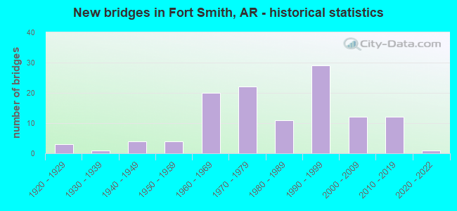
- New bridges - historical statistics
- 31920-1929
- 11930-1939
- 41940-1949
- 41950-1959
- 201960-1969
- 221970-1979
- 111980-1989
- 291990-1999
- 122000-2009
- 122010-2019
- 12020-2022
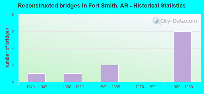
- Reconstructed bridges - Historical Statistics
- 11940-1949
- 11950-1959
- 21960-1969
- 01970-1979
- 61980-1989
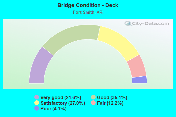
- Bridge Condition - Deck
- 21.6%Very good
- 35.1%Good
- 27.0%Satisfactory
- 12.2%Fair
- 4.1%Poor
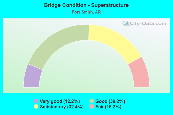
- Bridge Condition - Superstructure
- 12.2%Very good
- 39.2%Good
- 32.4%Satisfactory
- 16.2%Fair
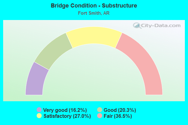
- Bridge Condition - Substructure
- 16.2%Very good
- 20.3%Good
- 27.0%Satisfactory
- 36.5%Fair
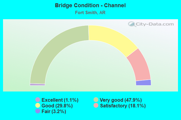
- Bridge Condition - Channel
- 1.1%Excellent
- 47.9%Very good
- 29.8%Good
- 18.1%Satisfactory
- 3.2%Fair
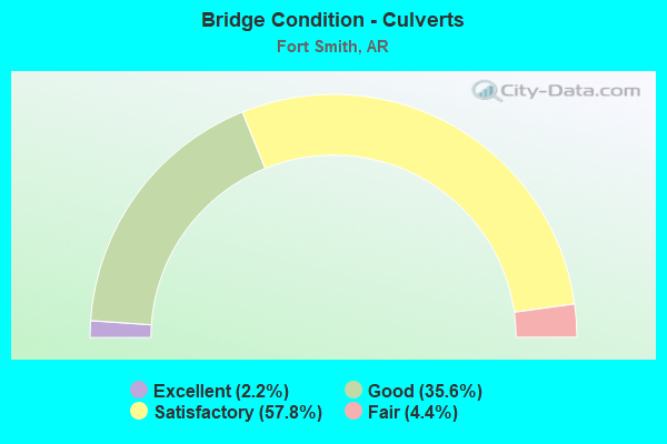
- Bridge Condition - Culverts
- 2.2%Excellent
- 35.6%Good
- 57.8%Satisfactory
- 4.4%Fair
Find on map >> Show street view
Structure Number: A0351, Location: 5.44 MI E JCT US 71 (Lat: 35.347028, Lng: -94.338097), Route carried "on" structure: State highway 22, Year Built: 1955, Year Reconstructed: 1974, Status: Open, Structure Length: 2.29m (7.51ft), Average Daily Traffic: 22,549 (year 2018), Truck Traffic: 1%, Average Future Daily Traffic: 26,358 (year 2028), Design Load: HS 20, Features Intersected: Little Massard Creek
Minimum Vertical Clearance: 30+ m (98+ ft), Kilometerpoint: 8.753, Lanes on structure: 5, Base Highway Network: Yes, Owner: State Highway Agency, Approaching Roadway Width: 17.7m (58.1ft), Skew: 3 degrees, Material/Design: Concrete, Design/Construction: Slab, Number Of Spans In Main Unit: 3, Length of Maximum Span: 7.6m (24.9ft), Curb or Sidewalk Widths: Left: 1.2m (3.9ft), Right: 1.2m (3.9ft), Curb-To-Curb Width: 15.2m (49.9ft), Out-to-Out Width: 18.3m (60.0ft)
Condition: Deck: Satisfactory, Superstructure: Satisfactory, Substructure: Fair, Channel: Very good, Operating Rating: 41.7 metric tons, Method Used To Determine Operating Rating: Load Factor (LF), Inventory Rating: 24.5 metric tons, Method Used To Determine Inventory Rating: Load Factor (LF), Structural Evaluation: Somewhat better than minimum adequacy, Deck Geometry: High priority of replacement, Waterway Adequacy: Equal to present desirable criteria, Approach Roadway Alignment: Equal to present desirable criteria, Length Of Structure Improvement: 3.08m (10.10ft), Designated Inspection Frequency: Every 24 months, Critical Feature Inspection Frequency: Every 24 months, Inspection Date: July 2020, Roadway Improvement Cost: $353,000, Total Project Cost: $768,000, Deck Structure Type: Concrete Cast-file-Place, Wearing Surface/Protective System: Wearing Surface: Bituminous
Find on map >> Show street view
Structure Number: A3604, Location: 1 MI N JCT SH 22 (Lat: 35.374031, Lng: -94.365139), Route carried "on" structure: Interstate 540, Year Built: 1965, Status: Open, Structure Length: 4.08m (13.39ft), Average Daily Traffic: 25,000 (year 2018), Truck Traffic: 1%, Average Future Daily Traffic: 52,057 (year 2028), Design Load: HS 20+Mod, Features Intersected: Free Ferry St. Seb. Co.
Minimum Vertical Clearance: 30+ m (98+ ft), Kilometerpoint: 12.472, Lanes on structure: 2, Lanes under structure: 2, Base Highway Network: Yes, Owner: State Highway Agency, Approaching Roadway Width: 11.6m (38.1ft), Skew: 1 degrees, Material/Design: Steel, Design/Construction: Stringer/Multi-beam, Number Of Spans In Main Unit: 3, Length of Maximum Span: 18.9m (62.0ft), Curb or Sidewalk Widths: Left: 0.5m (1.6ft), Right: 0.5m (1.6ft), Curb-To-Curb Width: 12.2m (40.0ft), Out-to-Out Width: 13.9m (45.6ft)
Condition: Deck: Very good, Superstructure: Fair, Substructure: Fair, Operating Rating: 54.4 metric tons, Method Used To Determine Operating Rating: Load Factor (LF), Inventory Rating: 32.7 metric tons, Method Used To Determine Inventory Rating: Load Factor (LF), Structural Evaluation: Somewhat better than minimum adequacy, Deck Geometry: Better than present minimum criteria, Underclear: Equal to present minimum criteria, Approach Roadway Alignment: Equal to present desirable criteria, Designated Inspection Frequency: Every 24 months, Critical Feature Inspection Frequency: Every 24 months, Inspection Date: August 2020, Deck Structure Type: Concrete Cast-file-Place, Wearing Surface/Protective System: Wearing Surface: Latex Concrete
Find on map >> Show street view
Structure Number: A5096, Location: 0.22 MI S JCT SH 22 (Lat: 35.354469, Lng: -94.365211), Route carried "on" structure: Interstate 540, Year Built: 1968, Year Reconstructed: 1988, Status: Open, Structure Length: 4.66m (15.29ft), Average Daily Traffic: 27,581 (year 2017), Truck Traffic: 1%, Average Future Daily Traffic: 36,242 (year 2028), Design Load: HS 20, Features Intersected: Boston Street-Sebastian
Minimum Vertical Clearance: 7.59m (24.90ft), Kilometerpoint: 10.316, Lanes on structure: 2, Lanes under structure: 2, Base Highway Network: Yes, Owner: State Highway Agency, Approaching Roadway Width: 12.8m (42.0ft), Material/Design: Steel, Design/Construction: Stringer/Multi-beam, Number Of Spans In Main Unit: 3, Length of Maximum Span: 16.8m (55.1ft), Curb-To-Curb Width: 12.6m (41.3ft), Out-to-Out Width: 13.5m (44.3ft)
Condition: Deck: Satisfactory, Superstructure: Good, Substructure: Fair, Operating Rating: 54.4 metric tons, Method Used To Determine Operating Rating: Load Factor (LF), Inventory Rating: 32.7 metric tons, Method Used To Determine Inventory Rating: Load Factor (LF), Structural Evaluation: Somewhat better than minimum adequacy, Deck Geometry: Better than present minimum criteria, Underclear: Meets minimum limits, Approach Roadway Alignment: Equal to present desirable criteria, Designated Inspection Frequency: Every 24 months, Critical Feature Inspection Frequency: Every 24 months, Inspection Date: July 2021, Deck Structure Type: Concrete Cast-file-Place, Wearing Surface/Protective System: Wearing Surface: Epoxy Overlay
Find on map >> Show street view
Structure Number: A5098, Location: 0.30 MI E OF SH 45 (Lat: 35.338569, Lng: -94.386431), Route carried "on" structure: Interstate 540, Year Built: 1968, Year Reconstructed: 1988, Status: Open, Structure Length: 4.85m (15.91ft), Average Daily Traffic: 24,000 (year 2018), Truck Traffic: 1%, Average Future Daily Traffic: 30,970 (year 2028), Design Load: HS 20+Mod, Features Intersected: Phoenix Street - Seb Co.
Minimum Vertical Clearance: 5.07m (16.63ft), Kilometerpoint: 7.532, Lanes on structure: 2, Lanes under structure: 4, Base Highway Network: Yes, Owner: State Highway Agency, Approaching Roadway Width: 12.5m (41.0ft), Skew: 3 degrees, Material/Design: Steel, Design/Construction: Stringer/Multi-beam, Number Of Spans In Main Unit: 3, Length of Maximum Span: 19.8m (65.0ft), Curb or Sidewalk Widths: Left: 0.0m, Right: 0.2m (0.7ft), Curb-To-Curb Width: 12.5m (41.0ft), Out-to-Out Width: 13.4m (44.0ft)
Condition: Deck: Very good, Superstructure: Satisfactory, Substructure: Fair, Operating Rating: 54.4 metric tons, Method Used To Determine Operating Rating: Load Factor (LF), Inventory Rating: 32.7 metric tons, Method Used To Determine Inventory Rating: Load Factor (LF), Structural Evaluation: Somewhat better than minimum adequacy, Deck Geometry: Better than present minimum criteria, Underclear: High priority of corrective action, Approach Roadway Alignment: Equal to present desirable criteria, Designated Inspection Frequency: Every 24 months, Critical Feature Inspection Frequency: Every 24 months, Inspection Date: May 2021, Deck Structure Type: Concrete Cast-file-Place, Wearing Surface/Protective System: Wearing Surface: Latex Concrete
Find on map >> Show street view
Structure Number: A51, Location: .50 MI S SH 45 (Lat: 35.330758, Lng: -94.394519), Route carried "on" structure: Interstate 540, Year Built: 1969, Status: Open, Structure Length: 4.72m (15.49ft), Average Daily Traffic: 23,795 (year 2017), Truck Traffic: 1%, Average Future Daily Traffic: 34,924 (year 2028), Design Load: HS 20+Mod, Features Intersected: Ft Smith Railroad Seb Co
Minimum Vertical Clearance: 30+ m (98+ ft), Kilometerpoint: 6.260, Lanes on structure: 2, Base Highway Network: Yes, Owner: State Highway Agency, Approaching Roadway Width: 12.8m (42.0ft), Material/Design: Steel, Design/Construction: Stringer/Multi-beam, Number Of Spans In Main Unit: 3, Length of Maximum Span: 16.2m (53.1ft), Curb-To-Curb Width: 12.8m (42.0ft), Out-to-Out Width: 13.8m (45.3ft)
Condition: Deck: Very good, Superstructure: Good, Substructure: Fair, Operating Rating: 54.4 metric tons, Method Used To Determine Operating Rating: Load Factor (LF), Inventory Rating: 32.7 metric tons, Method Used To Determine Inventory Rating: Load Factor (LF), Structural Evaluation: Somewhat better than minimum adequacy, Deck Geometry: Equal to present desirable criteria, Underclear: Equal to present minimum criteria, Approach Roadway Alignment: Equal to present desirable criteria, Designated Inspection Frequency: Every 24 months, Critical Feature Inspection Frequency: Every 24 months, Inspection Date: July 2020, Deck Structure Type: Concrete Cast-file-Place, Wearing Surface/Protective System: Wearing Surface: Latex Concrete
Find on map >> Show street view
Structure Number: A5101, Location: 0.73 SO JCT SH 45 (Lat: 35.327181, Lng: -94.394989), Route carried "on" structure: Interstate 540, Year Built: 1969, Status: Open, Structure Length: 5.64m (18.50ft), Average Daily Traffic: 23,795 (year 2017), Truck Traffic: 1%, Average Future Daily Traffic: 31,629 (year 2028), Design Load: HS 20+Mod, Features Intersected: SH 255 Sebastian Co.
Minimum Vertical Clearance: 30+ m (98+ ft), Kilometerpoint: 5.874, Lanes on structure: 2, Lanes under structure: 6, Base Highway Network: Yes, Owner: State Highway Agency, Approaching Roadway Width: 13.4m (44.0ft), Material/Design: Steel continuous, Design/Construction: Frame, Number Of Spans In Main Unit: 3, Length of Maximum Span: 25.3m (83.0ft), Curb or Sidewalk Widths: Left: 0.0m, Right: 0.1m (0.3ft), Curb-To-Curb Width: 12.7m (41.7ft), Out-to-Out Width: 13.4m (44.0ft)
Condition: Deck: Good, Superstructure: Satisfactory, Substructure: Satisfactory, Operating Rating: 43.5 metric tons, Method Used To Determine Operating Rating: Load Factor (LF), Inventory Rating: 25.4 metric tons, Method Used To Determine Inventory Rating: Load Factor (LF), Structural Evaluation: Equal to present minimum criteria, Deck Geometry: Better than present minimum criteria, Underclear: High priority of corrective action, Approach Roadway Alignment: Equal to present desirable criteria, Designated Inspection Frequency: Every 24 months, Critical Feature Inspection Frequency: Every 24 months, Inspection Date: September 2020, Deck Structure Type: Concrete Cast-file-Place, Wearing Surface/Protective System: Wearing Surface: Latex Concrete
Find on map >> Show street view
Structure Number: A5102, Location: JCT I540 & US 71 (Lat: 35.312303, Lng: -94.399231), Route carried "on" structure: Interstate 540, Year Built: 1975, Status: Open, Structure Length: 10.58m (34.71ft), Average Daily Traffic: 18,387 (year 2017), Truck Traffic: 1%, Average Future Daily Traffic: 21,745 (year 2028), Design Load: HS 20+Mod, Features Intersected: US 71-SEC 14, RR
Minimum Vertical Clearance: 30+ m (98+ ft), Kilometerpoint: 4.136, Lanes on structure: 2, Lanes under structure: 6, Base Highway Network: Yes, Owner: State Highway Agency, Approaching Roadway Width: 11.6m (38.1ft), Skew: 2 degrees, Material/Design: Steel, Design/Construction: Stringer/Multi-beam, Number Of Spans In Main Unit: 5, Length of Maximum Span: 23.8m (78.1ft), Curb-To-Curb Width: 12.6m (41.3ft), Out-to-Out Width: 13.3m (43.6ft)
Condition: Deck: Very good, Superstructure: Good, Substructure: Fair, Operating Rating: 54.4 metric tons, Method Used To Determine Operating Rating: Load Factor (LF), Inventory Rating: 32.7 metric tons, Method Used To Determine Inventory Rating: Load Factor (LF), Structural Evaluation: Somewhat better than minimum adequacy, Deck Geometry: Better than present minimum criteria, Underclear: Better than present minimum criteria, Approach Roadway Alignment: Equal to present desirable criteria, Designated Inspection Frequency: Every 24 months, Critical Feature Inspection Frequency: Every 24 months, Inspection Date: September 2020, Deck Structure Type: Concrete Cast-file-Place, Wearing Surface/Protective System: Wearing Surface: Epoxy Overlay
Find on map >> Show street view
Structure Number: A5103, Location: JCT 253, 271 & 540 (Lat: 35.293361, Lng: -94.423650), Route carried "on" structure: Interstate 540, Year Built: 1976, Status: Open, Structure Length: 5.64m (18.50ft), Average Daily Traffic: 13,000 (year 2018), Truck Traffic: 1%, Average Future Daily Traffic: 18,450 (year 2028), Design Load: HS 20+Mod, Features Intersected: US 271 Sebastian Co.
Minimum Vertical Clearance: 30+ m (98+ ft), Kilometerpoint: 1.046, Lanes on structure: 2, Lanes under structure: 5, Base Highway Network: Yes, Owner: State Highway Agency, Approaching Roadway Width: 11.6m (38.1ft), Skew: 2 degrees, Material/Design: Steel continuous, Design/Construction: Frame, Number Of Spans In Main Unit: 3, Length of Maximum Span: 25.3m (83.0ft), Curb or Sidewalk Widths: Left: 0.0m, Right: 0.1m (0.3ft), Curb-To-Curb Width: 12.6m (41.3ft), Out-to-Out Width: 13.6m (44.6ft)
Condition: Deck: Fair, Superstructure: Good, Substructure: Satisfactory, Operating Rating: 42.6 metric tons, Method Used To Determine Operating Rating: Load Factor (LF), Inventory Rating: 25.4 metric tons, Method Used To Determine Inventory Rating: Load Factor (LF), Structural Evaluation: Equal to present minimum criteria, Deck Geometry: Better than present minimum criteria, Underclear: Meets minimum limits, Approach Roadway Alignment: Equal to present desirable criteria, Designated Inspection Frequency: Every 24 months, Critical Feature Inspection Frequency: Every 24 months, Inspection Date: June 2020, Deck Structure Type: Concrete Cast-file-Place, Wearing Surface/Protective System: Wearing Surface: Monolithic Concrete
Find on map >> Show street view
Structure Number: A5629, Location: 0.95 MI W JCT I540 & 71 (Lat: 35.302839, Lng: -94.410450), Route carried "on" structure: Interstate 540, Year Built: 1977, Status: Open, Structure Length: 2.38m (7.81ft), Average Daily Traffic: 13,000 (year 2018), Truck Traffic: 1%, Average Future Daily Traffic: 21,745 (year 2028), Design Load: HS 20+Mod, Features Intersected: Jenny Lind Street
Minimum Vertical Clearance: 30+ m (98+ ft), Kilometerpoint: 2.672, Lanes on structure: 2, Lanes under structure: 4, Base Highway Network: Yes, Owner: State Highway Agency, Approaching Roadway Width: 12.5m (41.0ft), Material/Design: Steel, Design/Construction: Stringer/Multi-beam, Number Of Spans In Main Unit: 1, Length of Maximum Span: 23.8m (78.1ft), Curb-To-Curb Width: 12.6m (41.3ft), Out-to-Out Width: 13.6m (44.6ft)
Condition: Deck: Very good, Superstructure: Good, Substructure: Good, Operating Rating: 54.4 metric tons, Method Used To Determine Operating Rating: Load Factor (LF), Inventory Rating: 32.7 metric tons, Method Used To Determine Inventory Rating: Load Factor (LF), Structural Evaluation: Better than present minimum criteria, Deck Geometry: Better than present minimum criteria, Underclear: Somewhat better than minimum adequacy, Approach Roadway Alignment: Equal to present desirable criteria, Designated Inspection Frequency: Every 24 months, Critical Feature Inspection Frequency: Every 24 months, Inspection Date: July 2020, Deck Structure Type: Concrete Cast-file-Place, Wearing Surface/Protective System: Wearing Surface: Epoxy Overlay
Find on map >> Show street view
Structure Number: A6877, Location: 6.73 Mi NE OK State Line (Lat: 35.359381, Lng: -94.365131), Route carried "on" structure: Interstate 540, Year Built: 2013, Status: Open, Structure Length: 5.73m (18.80ft), Average Daily Traffic: 27,581 (year 2017), Truck Traffic: 12%, Average Future Daily Traffic: 36,242 (year 2028), Design Load: HS 20+Mod, Features Intersected: State Highway 22
Minimum Vertical Clearance: 30+ m (98+ ft), Kilometerpoint: 10.831, Lanes on structure: 3, Lanes under structure: 5, Base Highway Network: Yes, Owner: State Highway Agency, Approaching Roadway Width: 11.0m (36.1ft), Skew: 2 degrees, Material/Design: Steel continuous, Design/Construction: Stringer/Multi-beam, Number Of Spans In Main Unit: 2, Length of Maximum Span: 28.7m (94.2ft), Curb-To-Curb Width: 15.2m (49.9ft), Out-to-Out Width: 18.3m (60.0ft)
Condition: Deck: Very good, Superstructure: Very good, Substructure: Very good, Operating Rating: 54.4 metric tons, Method Used To Determine Operating Rating: Load Factor (LF), Inventory Rating: 32.7 metric tons, Method Used To Determine Inventory Rating: Load Factor (LF), Structural Evaluation: Equal to present desirable criteria, Deck Geometry: Meets minimum limits, Underclear: Equal to present minimum criteria, Approach Roadway Alignment: Equal to present desirable criteria, Designated Inspection Frequency: Every 24 months, Critical Feature Inspection Frequency: Every 24 months, Inspection Date: September 2021, Deck Structure Type: Concrete Cast-file-Place, Wearing Surface/Protective System: Wearing Surface: Epoxy Overlay, Deck Protection: Epoxy Coated Reinforcing
Find on map >> Show street view
Structure Number: A6878, Location: 6.24 Mi So Jct I40-11 (Lat: 35.384839, Lng: -94.364339), Route carried "on" structure: Interstate 540, Year Built: 2013, Status: Open, Structure Length: 5.30m (17.39ft), Average Daily Traffic: 25,000 (year 2018), Truck Traffic: 12%, Average Future Daily Traffic: 52,057 (year 2028), Design Load: HS 20+Mod, Features Intersected: Grand Avenue-Sebastian
Minimum Vertical Clearance: 5.12m (16.80ft), Kilometerpoint: 13.696, Lanes on structure: 2, Lanes under structure: 4, Base Highway Network: Yes, Owner: State Highway Agency, Approaching Roadway Width: 11.6m (38.1ft), Skew: 1 degrees, Material/Design: Steel continuous, Design/Construction: Stringer/Multi-beam, Number Of Spans In Main Unit: 4, Length of Maximum Span: 13.1m (43.0ft), Curb-To-Curb Width: 12.2m (40.0ft), Out-to-Out Width: 13.2m (43.3ft)
Condition: Deck: Good, Superstructure: Very good, Substructure: Good, Operating Rating: 54.4 metric tons, Method Used To Determine Operating Rating: Load Factor (LF), Inventory Rating: 32.7 metric tons, Method Used To Determine Inventory Rating: Load Factor (LF), Structural Evaluation: Better than present minimum criteria, Deck Geometry: Somewhat better than minimum adequacy, Underclear: Meets minimum limits, Approach Roadway Alignment: Equal to present desirable criteria, Designated Inspection Frequency: Every 24 months, Critical Feature Inspection Frequency: Every 24 months, Inspection Date: July 2021, Deck Structure Type: Concrete Cast-file-Place, Wearing Surface/Protective System: Wearing Surface: Epoxy Overlay, Deck Protection: Epoxy Coated Reinforcing
Find on map >> Show street view
Structure Number: A6879, Location: 9.14 Mi N. OK State Line (Lat: 35.393961, Lng: -94.366139), Route carried "on" structure: Interstate 540, Year Built: 2013, Status: Open, Structure Length: 4.94m (16.21ft), Average Daily Traffic: 25,500 (year 2018), Truck Traffic: 12%, Average Future Daily Traffic: 37,560 (year 2028), Design Load: HS 20+Mod, Features Intersected: Clayton Branch-Sebastian
Minimum Vertical Clearance: 30+ m (98+ ft), Kilometerpoint: 14.709, Lanes on structure: 2, Base Highway Network: Yes, Owner: State Highway Agency, Approaching Roadway Width: 11.6m (38.1ft), Skew: 34 degrees, Material/Design: Steel continuous, Design/Construction: Stringer/Multi-beam, Number Of Spans In Main Unit: 3, Length of Maximum Span: 16.2m (53.1ft), Curb-To-Curb Width: 12.2m (40.0ft), Out-to-Out Width: 13.2m (43.3ft)
Condition: Deck: Good, Superstructure: Very good, Substructure: Good, Channel: Very good, Operating Rating: 54.4 metric tons, Method Used To Determine Operating Rating: Load Factor (LF), Inventory Rating: 32.7 metric tons, Method Used To Determine Inventory Rating: Load Factor (LF), Structural Evaluation: Better than present minimum criteria, Deck Geometry: Somewhat better than minimum adequacy, Waterway Adequacy: Equal to present desirable criteria, Approach Roadway Alignment: Equal to present desirable criteria, Designated Inspection Frequency: Every 24 months, Critical Feature Inspection Frequency: Every 24 months, Inspection Date: July 2021, Deck Structure Type: Concrete Cast-file-Place, Wearing Surface/Protective System: Wearing Surface: Epoxy Overlay, Deck Protection: Epoxy Coated Reinforcing
Find on map >> Show street view
Structure Number: B3604, Location: 1 MI NO JCT SH 22 (Lat: 35.374031, Lng: -94.364853), Route carried "on" structure: Interstate 540, Year Built: 1965, Status: Open, Structure Length: 4.08m (13.39ft), Average Daily Traffic: 25,000 (year 2018), Truck Traffic: 13%, Average Future Daily Traffic: 52,057 (year 2028), Design Load: HS 20+Mod, Features Intersected: Free Ferry St. Seb. Co.
Minimum Vertical Clearance: 30+ m (98+ ft), Kilometerpoint: 12.472, Lanes on structure: 2, Lanes under structure: 2, Base Highway Network: Yes, Owner: State Highway Agency, Approaching Roadway Width: 11.6m (38.1ft), Skew: 1 degrees, Material/Design: Steel, Design/Construction: Stringer/Multi-beam, Number Of Spans In Main Unit: 3, Length of Maximum Span: 18.9m (62.0ft), Curb or Sidewalk Widths: Left: 0.5m (1.6ft), Right: 0.5m (1.6ft), Curb-To-Curb Width: 12.2m (40.0ft), Out-to-Out Width: 13.9m (45.6ft)
Condition: Deck: Very good, Superstructure: Fair, Substructure: Fair, Operating Rating: 54.4 metric tons, Method Used To Determine Operating Rating: Load Factor (LF), Inventory Rating: 32.7 metric tons, Method Used To Determine Inventory Rating: Load Factor (LF), Structural Evaluation: Somewhat better than minimum adequacy, Deck Geometry: Better than present minimum criteria, Underclear: Equal to present minimum criteria, Approach Roadway Alignment: Equal to present desirable criteria, Designated Inspection Frequency: Every 24 months, Critical Feature Inspection Frequency: Every 24 months, Inspection Date: August 2020, Deck Structure Type: Concrete Cast-file-Place, Wearing Surface/Protective System: Wearing Surface: Latex Concrete
Find on map >> Show street view
Structure Number: B5096, Location: 2.01 MI NO OF SH 45 (Lat: 35.354481, Lng: -94.365069), Route carried "on" structure: Interstate 540, Year Built: 1968, Year Reconstructed: 1988, Status: Open, Structure Length: 4.66m (15.29ft), Average Daily Traffic: 27,581 (year 2017), Truck Traffic: 1%, Average Future Daily Traffic: 36,242 (year 2028), Design Load: HS 20, Features Intersected: Boston St. Seb. Co.
Minimum Vertical Clearance: 30+ m (98+ ft), Kilometerpoint: 10.316, Lanes on structure: 2, Lanes under structure: 2, Base Highway Network: Yes, Owner: State Highway Agency, Approaching Roadway Width: 12.8m (42.0ft), Material/Design: Steel, Design/Construction: Stringer/Multi-beam, Number Of Spans In Main Unit: 3, Length of Maximum Span: 16.8m (55.1ft), Curb-To-Curb Width: 12.6m (41.3ft), Out-to-Out Width: 13.5m (44.3ft)
Condition: Deck: Very good, Superstructure: Good, Substructure: Fair, Operating Rating: 54.4 metric tons, Method Used To Determine Operating Rating: Load Factor (LF), Inventory Rating: 32.7 metric tons, Method Used To Determine Inventory Rating: Load Factor (LF), Structural Evaluation: Somewhat better than minimum adequacy, Deck Geometry: Better than present minimum criteria, Underclear: Meets minimum limits, Approach Roadway Alignment: Equal to present desirable criteria, Designated Inspection Frequency: Every 24 months, Critical Feature Inspection Frequency: Every 24 months, Inspection Date: July 2020, Deck Structure Type: Concrete Cast-file-Place, Wearing Surface/Protective System: Wearing Surface: Epoxy Overlay
Find on map >> Show street view
Structure Number: B5098, Location: 0.3 MI NO OF SH 45 (Lat: 35.338489, Lng: -94.386311), Route carried "on" structure: Interstate 540, Year Built: 1968, Year Reconstructed: 1988, Status: Open, Structure Length: 4.85m (15.91ft), Average Daily Traffic: 24,000 (year 2018), Truck Traffic: 1%, Average Future Daily Traffic: 30,970 (year 2028), Design Load: HS 20+Mod, Features Intersected: Phoenix Street - Seb. Co
Minimum Vertical Clearance: 30+ m (98+ ft), Kilometerpoint: 7.532, Lanes on structure: 2, Lanes under structure: 4, Base Highway Network: Yes, Owner: State Highway Agency, Approaching Roadway Width: 12.5m (41.0ft), Skew: 3 degrees, Material/Design: Steel, Design/Construction: Stringer/Multi-beam, Number Of Spans In Main Unit: 3, Length of Maximum Span: 19.8m (65.0ft), Curb-To-Curb Width: 12.5m (41.0ft), Out-to-Out Width: 13.4m (44.0ft)
Condition: Deck: Very good, Superstructure: Satisfactory, Substructure: Fair, Operating Rating: 54.4 metric tons, Method Used To Determine Operating Rating: Load Factor (LF), Inventory Rating: 32.7 metric tons, Method Used To Determine Inventory Rating: Load Factor (LF), Structural Evaluation: Somewhat better than minimum adequacy, Deck Geometry: Better than present minimum criteria, Underclear: High priority of corrective action, Approach Roadway Alignment: Equal to present desirable criteria, Designated Inspection Frequency: Every 24 months, Critical Feature Inspection Frequency: Every 24 months, Inspection Date: May 2021, Deck Structure Type: Concrete Cast-file-Place, Wearing Surface/Protective System: Wearing Surface: Latex Concrete
Find on map >> Show street view
Structure Number: B51, Location: 0.49 MI SO OF SH 45 (Lat: 35.330750, Lng: -94.394378), Route carried "on" structure: Interstate 540, Year Built: 1969, Status: Open, Structure Length: 4.72m (15.49ft), Average Daily Traffic: 23,795 (year 2017), Truck Traffic: 7%, Average Future Daily Traffic: 34,924 (year 2028), Design Load: HS 20+Mod, Features Intersected: Ft Smith Railroad Seb Co
Minimum Vertical Clearance: 30+ m (98+ ft), Kilometerpoint: 6.260, Lanes on structure: 3, Base Highway Network: Yes, Owner: State Highway Agency, Approaching Roadway Width: 15.2m (49.9ft), Material/Design: Steel, Design/Construction: Stringer/Multi-beam, Number Of Spans In Main Unit: 3, Length of Maximum Span: 16.2m (53.1ft), Curb or Sidewalk Widths: Left: 0.0m, Right: 0.1m (0.3ft), Curb-To-Curb Width: 15.2m (49.9ft), Out-to-Out Width: 15.8m (51.8ft)
Condition: Deck: Very good, Superstructure: Good, Substructure: Fair, Operating Rating: 54.4 metric tons, Method Used To Determine Operating Rating: Load Factor (LF), Inventory Rating: 32.7 metric tons, Method Used To Determine Inventory Rating: Load Factor (LF), Structural Evaluation: Somewhat better than minimum adequacy, Deck Geometry: Meets minimum limits, Underclear: Equal to present minimum criteria, Approach Roadway Alignment: Equal to present desirable criteria, Designated Inspection Frequency: Every 24 months, Critical Feature Inspection Frequency: Every 24 months, Inspection Date: July 2020, Deck Structure Type: Concrete Cast-file-Place, Wearing Surface/Protective System: Wearing Surface: Latex Concrete
Find on map >> Show street view
Structure Number: B5101, Location: 0.73 MI SO OF SH 45 (Lat: 35.327178, Lng: -94.394853), Route carried "on" structure: Interstate 540, Year Built: 1969, Status: Open, Structure Length: 5.64m (18.50ft), Average Daily Traffic: 23,795 (year 2017), Truck Traffic: 1%, Average Future Daily Traffic: 31,629 (year 2028), Design Load: HS 20+Mod, Features Intersected: SH 255 Sebastian Co.
Minimum Vertical Clearance: 30+ m (98+ ft), Kilometerpoint: 5.874, Lanes on structure: 2, Lanes under structure: 6, Base Highway Network: Yes, Owner: State Highway Agency, Approaching Roadway Width: 12.2m (40.0ft), Material/Design: Steel continuous, Design/Construction: Frame, Number Of Spans In Main Unit: 3, Length of Maximum Span: 25.3m (83.0ft), Curb or Sidewalk Widths: Left: 0.2m (0.7ft), Right: 0.0m, Curb-To-Curb Width: 12.8m (42.0ft), Out-to-Out Width: 13.4m (44.0ft)
Condition: Deck: Very good, Superstructure: Good, Substructure: Satisfactory, Operating Rating: 42.6 metric tons, Method Used To Determine Operating Rating: Load Factor (LF), Inventory Rating: 25.4 metric tons, Method Used To Determine Inventory Rating: Load Factor (LF), Structural Evaluation: Equal to present minimum criteria, Deck Geometry: Equal to present desirable criteria, Underclear: High priority of corrective action, Approach Roadway Alignment: Equal to present desirable criteria, Designated Inspection Frequency: Every 24 months, Critical Feature Inspection Frequency: Every 24 months, Inspection Date: August 2020, Deck Structure Type: Concrete Cast-file-Place, Wearing Surface/Protective System: Wearing Surface: Latex Concrete
Find on map >> Show street view
Structure Number: B5102, Location: JCT I540 & US 71 (Lat: 35.312181, Lng: -94.399161), Route carried "on" structure: Interstate 540, Year Built: 1975, Status: Open, Structure Length: 10.58m (34.71ft), Average Daily Traffic: 18,387 (year 2017), Truck Traffic: 1%, Average Future Daily Traffic: 21,745 (year 2028), Design Load: HS 20+Mod, Features Intersected: US 71-SEC 14, RR
Minimum Vertical Clearance: 30+ m (98+ ft), Kilometerpoint: 4.136, Lanes on structure: 2, Lanes under structure: 6, Base Highway Network: Yes, Owner: State Highway Agency, Approaching Roadway Width: 11.6m (38.1ft), Skew: 2 degrees, Material/Design: Steel, Design/Construction: Stringer/Multi-beam, Number Of Spans In Main Unit: 5, Length of Maximum Span: 23.8m (78.1ft), Curb-To-Curb Width: 12.6m (41.3ft), Out-to-Out Width: 13.3m (43.6ft)
Condition: Deck: Very good, Superstructure: Good, Substructure: Fair, Operating Rating: 54.4 metric tons, Method Used To Determine Operating Rating: Load Factor (LF), Inventory Rating: 32.7 metric tons, Method Used To Determine Inventory Rating: Load Factor (LF), Structural Evaluation: Somewhat better than minimum adequacy, Deck Geometry: Better than present minimum criteria, Underclear: Better than present minimum criteria, Approach Roadway Alignment: Equal to present desirable criteria, Designated Inspection Frequency: Every 24 months, Critical Feature Inspection Frequency: Every 24 months, Inspection Date: September 2020, Deck Structure Type: Concrete Cast-file-Place, Wearing Surface/Protective System: Wearing Surface: Epoxy Overlay
Find on map >> Show street view
Structure Number: B5103, Location: 0.65 Mi E of Ok St Line (Lat: 35.293231, Lng: -94.423650), Route carried "on" structure: Interstate 540, Year Built: 1976, Status: Open, Structure Length: 5.64m (18.50ft), Average Daily Traffic: 13,000 (year 2018), Truck Traffic: 6%, Average Future Daily Traffic: 18,450 (year 2028), Design Load: HS 20+Mod, Features Intersected: US 271 Sebastian Co.
Minimum Vertical Clearance: 30+ m (98+ ft), Kilometerpoint: 1.046, Lanes on structure: 2, Lanes under structure: 5, Base Highway Network: Yes, Owner: State Highway Agency, Approaching Roadway Width: 11.6m (38.1ft), Skew: 2 degrees, Material/Design: Steel continuous, Design/Construction: Frame, Number Of Spans In Main Unit: 3, Length of Maximum Span: 25.3m (83.0ft), Curb or Sidewalk Widths: Left: 0.1m (0.3ft), Right: 0.0m, Curb-To-Curb Width: 12.6m (41.3ft), Out-to-Out Width: 13.3m (43.6ft)
Condition: Deck: Fair, Superstructure: Good, Substructure: Satisfactory, Operating Rating: 54.4 metric tons, Method Used To Determine Operating Rating: Load Factor (LF), Inventory Rating: 32.7 metric tons, Method Used To Determine Inventory Rating: Load Factor (LF), Structural Evaluation: Equal to present minimum criteria, Deck Geometry: Better than present minimum criteria, Underclear: Meets minimum limits, Approach Roadway Alignment: Equal to present desirable criteria, Designated Inspection Frequency: Every 24 months, Critical Feature Inspection Frequency: Every 24 months, Inspection Date: June 2020, Deck Structure Type: Concrete Cast-file-Place, Wearing Surface/Protective System: Wearing Surface: Monolithic Concrete
Find on map >> Show street view
Structure Number: B5629, Location: 0.95 MI W JCT US 71 & 540 (Lat: 35.302750, Lng: -94.410339), Route carried "on" structure: Interstate 540, Year Built: 1977, Status: Open, Structure Length: 2.38m (7.81ft), Average Daily Traffic: 13,000 (year 2018), Truck Traffic: 6%, Average Future Daily Traffic: 34,600 (year 2038), Design Load: HS 20+Mod, Features Intersected: Jenny Lind Street
Minimum Vertical Clearance: 30+ m (98+ ft), Kilometerpoint: 2.672, Lanes on structure: 2, Lanes under structure: 4, Base Highway Network: Yes, Owner: State Highway Agency, Approaching Roadway Width: 12.5m (41.0ft), Material/Design: Steel, Design/Construction: Stringer/Multi-beam, Number Of Spans In Main Unit: 1, Length of Maximum Span: 23.2m (76.1ft), Curb-To-Curb Width: 12.6m (41.3ft), Out-to-Out Width: 13.3m (43.6ft)
Condition: Deck: Very good, Superstructure: Good, Substructure: Good, Operating Rating: 54.4 metric tons, Method Used To Determine Operating Rating: Load Factor (LF), Inventory Rating: 32.7 metric tons, Method Used To Determine Inventory Rating: Load Factor (LF), Structural Evaluation: Better than present minimum criteria, Deck Geometry: Better than present minimum criteria, Underclear: Somewhat better than minimum adequacy, Approach Roadway Alignment: Equal to present desirable criteria, Designated Inspection Frequency: Every 24 months, Critical Feature Inspection Frequency: Every 24 months, Inspection Date: July 2020, Deck Structure Type: Concrete Cast-file-Place, Wearing Surface/Protective System: Wearing Surface: Epoxy Overlay
Find on map >> Show street view
Structure Number: B6877, Location: 6.73 Mi NE OK state line (Lat: 35.359250, Lng: -94.364850), Route carried "on" structure: Interstate 540, Year Built: 2013, Status: Open, Structure Length: 5.73m (18.80ft), Average Daily Traffic: 27,581 (year 2017), Truck Traffic: 12%, Average Future Daily Traffic: 73,100 (year 2026), Design Load: HS 20+Mod, Features Intersected: State Highway 22
Minimum Vertical Clearance: 30+ m (98+ ft), Kilometerpoint: 10.831, Lanes on structure: 3, Lanes under structure: 5, Base Highway Network: Yes, Owner: State Highway Agency, Approaching Roadway Width: 14.8m (48.6ft), Skew: 2 degrees, Material/Design: Steel continuous, Design/Construction: Stringer/Multi-beam, Number Of Spans In Main Unit: 2, Length of Maximum Span: 28.3m (92.8ft), Curb-To-Curb Width: 14.8m (48.6ft), Out-to-Out Width: 15.6m (51.2ft)
Condition: Deck: Good, Superstructure: Very good, Substructure: Very good, Operating Rating: 54.4 metric tons, Method Used To Determine Operating Rating: Load Factor (LF), Inventory Rating: 32.7 metric tons, Method Used To Determine Inventory Rating: Load Factor (LF), Structural Evaluation: Equal to present desirable criteria, Deck Geometry: Meets minimum limits, Underclear: Equal to present minimum criteria, Approach Roadway Alignment: Equal to present desirable criteria, Designated Inspection Frequency: Every 24 months, Critical Feature Inspection Frequency: Every 24 months, Inspection Date: March 2020, Deck Structure Type: Concrete Cast-file-Place, Wearing Surface/Protective System: Wearing Surface: Monolithic Concrete, Deck Protection: Epoxy Coated Reinforcing
Find on map >> Show street view
Structure Number: B6878, Location: 1.77 MI N SH 22 (Lat: 35.384831, Lng: -94.364061), Route carried "on" structure: Interstate 540, Year Built: 2013, Status: Open, Structure Length: 5.31m (17.42ft), Average Daily Traffic: 25,000 (year 2018), Truck Traffic: 13%, Average Future Daily Traffic: 66,600 (year 2038), Design Load: HS 20+Mod, Features Intersected: Grand Avenue-Seb. Co.
Minimum Vertical Clearance: 30+ m (98+ ft), Kilometerpoint: 13.692, Lanes on structure: 2, Lanes under structure: 3, Base Highway Network: Yes, Owner: State Highway Agency, Approaching Roadway Width: 12.4m (40.7ft), Skew: 1 degrees, Material/Design: Steel continuous, Design/Construction: Stringer/Multi-beam, Number Of Spans In Main Unit: 4, Length of Maximum Span: 13.1m (43.0ft), Curb or Sidewalk Widths: Left: 0.3m (1.0ft), Right: 0.3m (1.0ft), Curb-To-Curb Width: 12.2m (40.0ft), Out-to-Out Width: 13.1m (43.0ft)
Condition: Deck: Very good, Superstructure: Very good, Substructure: Very good, Operating Rating: 54.4 metric tons, Method Used To Determine Operating Rating: Load Factor (LF), Inventory Rating: 32.7 metric tons, Method Used To Determine Inventory Rating: Load Factor (LF), Structural Evaluation: Equal to present desirable criteria, Deck Geometry: Better than present minimum criteria, Underclear: Meets minimum limits, Approach Roadway Alignment: Equal to present desirable criteria, Designated Inspection Frequency: Every 24 months, Critical Feature Inspection Frequency: Every 24 months, Inspection Date: March 2020, Deck Structure Type: Concrete Cast-file-Place, Wearing Surface/Protective System: Wearing Surface: Monolithic Concrete
Find on map >> Show street view
Structure Number: B6879, Location: 9.14 Mi N. OK State Line (Lat: 35.393778, Lng: -94.365808), Route carried "on" structure: Interstate 540, Year Built: 2014, Status: Open, Structure Length: 4.94m (16.21ft), Average Daily Traffic: 25,500 (year 2018), Truck Traffic: 12%, Average Future Daily Traffic: 37,560 (year 2028), Design Load: HS 20+Mod, Features Intersected: Clayton Branch-Seb. Co.
Minimum Vertical Clearance: 30+ m (98+ ft), Kilometerpoint: 14.709, Lanes on structure: 2, Base Highway Network: Yes, Owner: State Highway Agency, Approaching Roadway Width: 11.4m (37.4ft), Skew: 4 degrees, Material/Design: Steel continuous, Design/Construction: Stringer/Multi-beam, Number Of Spans In Main Unit: 3, Length of Maximum Span: 16.2m (53.1ft), Curb-To-Curb Width: 12.2m (40.0ft), Out-to-Out Width: 13.2m (43.3ft)
Condition: Deck: Very good, Superstructure: Very good, Substructure: Very good, Channel: Very good, Operating Rating: 54.4 metric tons, Method Used To Determine Operating Rating: Load Factor (LF), Inventory Rating: 32.7 metric tons, Method Used To Determine Inventory Rating: Load Factor (LF), Structural Evaluation: Equal to present desirable criteria, Deck Geometry: Somewhat better than minimum adequacy, Waterway Adequacy: Equal to present desirable criteria, Approach Roadway Alignment: Equal to present desirable criteria, Designated Inspection Frequency: Every 24 months, Critical Feature Inspection Frequency: Every 24 months, Inspection Date: March 2020, Deck Structure Type: Concrete Cast-file-Place, Wearing Surface/Protective System: Wearing Surface: Monolithic Concrete
Find on map >> Show street view
Structure Number: M1378, Location: 3.18 MI NW OF SH 10 (Lat: 35.236200, Lng: -94.328531), Route carried "on" structure: US 71, Year Built: 1963, Year Reconstructed: 1988, Status: Open, Structure Length: 1.40m (4.59ft), Average Daily Traffic: 25,967 (year 2018), Truck Traffic: 6%, Average Future Daily Traffic: 35,583 (year 2028), Design Load: H 15, Features Intersected: Bear Hollow Creek
Minimum Vertical Clearance: 30+ m (98+ ft), Kilometerpoint: 5.118, Lanes on structure: 2, Base Highway Network: Yes, Owner: State Highway Agency, Approaching Roadway Width: 12.2m (40.0ft), Skew: 4 degrees, Material/Design: Concrete, Design/Construction: Culvert, Number Of Spans In Main Unit: 3, Length of Maximum Span: 4.6m (15.1ft)
Condition: Channel: Satisfactory, Culverts: Satisfactory, Operating Rating: 39.9 metric tons, Method Used To Determine Operating Rating: Load Factor (LF), Inventory Rating: 23.6 metric tons, Method Used To Determine Inventory Rating: Load Factor (LF), Structural Evaluation: Somewhat better than minimum adequacy, Waterway Adequacy: Equal to present desirable criteria, Approach Roadway Alignment: Equal to present desirable criteria, Designated Inspection Frequency: Every 24 months, Critical Feature Inspection Frequency: Every 24 months, Inspection Date: July 2021
Find on map >> Show street view
Structure Number: M3218, Location: 0.49 MI E US 71 (Lat: 35.651733, Lng: -94.153325), Route carried "on" structure: City street 31820, Year Built: 1930, Status: Open, Structure Length: 3.72m (12.20ft), Average Daily Traffic: 134 (year 2018), Truck Traffic: 1%, Average Future Daily Traffic: 72 (year 2007), Design Load: H 10, Features Intersected: Warloop Creek-Crawford, Facility Carried by Structure: Lake Fort Smith Rd
Minimum Vertical Clearance: 30+ m (98+ ft), Kilometerpoint: 0.789, Lanes on structure: 2, Owner: City or Municipal Highway Agency, Approaching Roadway Width: 6.7m (22.0ft), Material/Design: Concrete, Design/Construction: Tee Beam, Number Of Spans In Main Unit: 3, Length of Maximum Span: 12.2m (40.0ft), Curb or Sidewalk Widths: Left: 0.2m (0.7ft), Right: 0.2m (0.7ft), Curb-To-Curb Width: 6.7m (22.0ft), Out-to-Out Width: 7.8m (25.6ft)
Condition: Deck: Satisfactory, Superstructure: Fair, Substructure: Satisfactory, Channel: Good, Operating Rating: 45.4 metric tons, Method Used To Determine Operating Rating: Load Factor (LF), Inventory Rating: 27.2 metric tons, Method Used To Determine Inventory Rating: Load Factor (LF), Structural Evaluation: Somewhat better than minimum adequacy, Deck Geometry: Meets minimum limits, Waterway Adequacy: Equal to present desirable criteria, Approach Roadway Alignment: Better than present minimum criteria, Designated Inspection Frequency: Every 24 months, Critical Feature Inspection Frequency: Every 24 months, Inspection Date: April 2020, Deck Structure Type: Concrete Cast-file-Place, Wearing Surface/Protective System: Wearing Surface: Bituminous
Find on map >> Show street view
Structure Number: X0089, Location: 1.5 MI N JCT SH 22 & 540 (Lat: 35.380761, Lng: -94.365111), Route carried "on" structure: Interstate 540, Year Built: 1965, Status: Open, Structure Length: 0.91m (2.99ft), Average Daily Traffic: 50,000 (year 2018), Truck Traffic: 13%, Average Future Daily Traffic: 66,600 (year 2038), Design Load: H 20, Features Intersected: Creek - Seb. Co.
Minimum Vertical Clearance: 30+ m (98+ ft), Kilometerpoint: 13.161, Lanes on structure: 5, Base Highway Network: Yes, Owner: State Highway Agency, Approaching Roadway Width: 11.0m (36.1ft), Skew: 4 degrees, Material/Design: Concrete, Design/Construction: Culvert, Number Of Spans In Main Unit: 2, Length of Maximum Span: 4.6m (15.1ft)
Condition: Channel: Good, Culverts: Satisfactory, Operating Rating: 39.9 metric tons, Method Used To Determine Operating Rating: Load Factor (LF), Inventory Rating: 23.6 metric tons, Method Used To Determine Inventory Rating: Load Factor (LF), Structural Evaluation: Somewhat better than minimum adequacy, Waterway Adequacy: Equal to present desirable criteria, Approach Roadway Alignment: Equal to present desirable criteria, Designated Inspection Frequency: Every 24 months, Critical Feature Inspection Frequency: Every 24 months, Inspection Date: August 2021
Find on map >> Show street view
Structure Number: X0201, Location: 2.2 MI E US 71 (Lat: 35.326989, Lng: -94.372161), Route carried "on" structure: State highway 255, Year Built: 1972, Status: Open, Structure Length: 2.29m (7.51ft), Average Daily Traffic: 21,655 (year 2018), Truck Traffic: 5%, Average Future Daily Traffic: 30,311 (year 2028), Design Load: H 20, Features Intersected: Little Creek-Seb. Co.
Minimum Vertical Clearance: 30+ m (98+ ft), Kilometerpoint: 6.420, Lanes on structure: 5, Base Highway Network: Yes, Owner: State Highway Agency, Approaching Roadway Width: 19.5m (64.0ft), Skew: 5 degrees, Material/Design: Concrete, Design/Construction: Culvert, Number Of Spans In Main Unit: 5, Length of Maximum Span: 4.6m (15.1ft)
Condition: Channel: Satisfactory, Culverts: Satisfactory, Operating Rating: 32.7 metric tons, Method Used To Determine Operating Rating: Load Factor (LF), Inventory Rating: 19.1 metric tons, Method Used To Determine Inventory Rating: Load Factor (LF), Structural Evaluation: Meets minimum limits, Waterway Adequacy: Equal to present desirable criteria, Approach Roadway Alignment: Equal to present desirable criteria, Designated Inspection Frequency: Every 24 months, Critical Feature Inspection Frequency: Every 24 months, Inspection Date: January 2022
Find on map >> Show street view
Structure Number: X036, Location: 0.2 MI W US 71 (Lat: 35.310131, Lng: -94.401200), Route carried "on" structure: Interstate 540, Year Built: 1977, Status: Open, Structure Length: 0.70m (2.30ft), Average Daily Traffic: 36,774 (year 2017), Truck Traffic: 1%, Average Future Daily Traffic: 45,300 (year 2038), Features Intersected: Mill Creek Seb. Co.
Minimum Vertical Clearance: 30+ m (98+ ft), Kilometerpoint: 3.813, Lanes on structure: 6, Base Highway Network: Yes, Owner: State Highway Agency, Approaching Roadway Width: 7.3m (24.0ft), Skew: 1 degrees, Material/Design: Concrete, Design/Construction: Culvert, Number Of Spans In Main Unit: 3, Length of Maximum Span: 2.4m (7.9ft)
Condition: Channel: Very good, Culverts: Satisfactory, Operating Rating: 29.9 metric tons, Method Used To Determine Operating Rating: Load Factor (LF), Inventory Rating: 18.1 metric tons, Method Used To Determine Inventory Rating: Load Factor (LF), Structural Evaluation: Meets minimum limits, Waterway Adequacy: Equal to present desirable criteria, Approach Roadway Alignment: Equal to present desirable criteria, Designated Inspection Frequency: Every 24 months, Critical Feature Inspection Frequency: Every 24 months, Inspection Date: August 2020
Find on map >> Show street view
Structure Number: X0361, Location: 250 Ft E Jct I540 & 253 (Lat: 35.293781, Lng: -94.422350), Route carried "on" structure: Interstate 540, Year Built: 1977, Status: Open, Structure Length: 0.61m (2.00ft), Average Daily Traffic: 26,000 (year 2018), Truck Traffic: 6%, Average Future Daily Traffic: 36,901 (year 2028), Features Intersected: Creek-Sebastian Co.
Minimum Vertical Clearance: 30+ m (98+ ft), Kilometerpoint: 1.143, Lanes on structure: 6, Base Highway Network: Yes, Owner: State Highway Agency, Approaching Roadway Width: 7.6m (24.9ft), Skew: 1 degrees, Material/Design: Concrete, Design/Construction: Culvert, Number Of Spans In Main Unit: 3, Length of Maximum Span: 2.1m (6.9ft)
Condition: Channel: Good, Culverts: Satisfactory, Operating Rating: 28.1 metric tons, Method Used To Determine Operating Rating: Load Factor (LF), Inventory Rating: 16.3 metric tons, Method Used To Determine Inventory Rating: Load Factor (LF), Structural Evaluation: Meets minimum limits, Waterway Adequacy: Equal to present desirable criteria, Approach Roadway Alignment: Equal to present desirable criteria, Designated Inspection Frequency: Every 24 months, Critical Feature Inspection Frequency: Every 24 months, Inspection Date: Febuary 2022
Find on map >> Show street view
Structure Number: X0819, Location: 25 Ft West Jct US 71 (Lat: 35.305200, Lng: -94.394381), Route carried "on" structure: City street , Year Built: 1992, Status: Open, Structure Length: 0.75m (2.46ft), Average Daily Traffic: 4,000 (year 2014), Truck Traffic: 1%, Average Future Daily Traffic: 1,100 (year 2028), Design Load: H 20, Features Intersected: Ditch, Facility Carried by Structure: Grinnell Ave Seb.
Minimum Vertical Clearance: 30+ m (98+ ft), Kilometerpoint: 0.016, Lanes on structure: 2, Owner: State Highway Agency, Approaching Roadway Width: 11.0m (36.1ft), Material/Design: Concrete, Design/Construction: Culvert, Number Of Spans In Main Unit: 2, Length of Maximum Span: 3.7m (12.1ft)
Condition: Channel: Very good, Culverts: Satisfactory, Operating Rating: 31.8 metric tons, Method Used To Determine Operating Rating: Load Factor (LF), Inventory Rating: 19.1 metric tons, Method Used To Determine Inventory Rating: Load Factor (LF), Structural Evaluation: Somewhat better than minimum adequacy, Waterway Adequacy: Equal to present desirable criteria, Approach Roadway Alignment: Equal to present minimum criteria, Designated Inspection Frequency: Every 48 months, Critical Feature Inspection Frequency: Every 24 months, Inspection Date: October 2021
Find on map >> Show street view
Structure Number: X09, Location: 6800 PHOENIX AVE. (Lat: 35.347389, Lng: -94.357056), Route carried "on" structure: City street 45140, Year Built: 1996, Status: Open, Structure Length: 0.98m (3.22ft), Average Daily Traffic: 18,000 (year 2018), Truck Traffic: 1%, Average Future Daily Traffic: 5 (year 2007), Design Load: HS 20, Features Intersected: Ditch City of Ft. Smith, Facility Carried by Structure: Phoenix Avenue
Minimum Vertical Clearance: 30+ m (98+ ft), Kilometerpoint: 7.582, Lanes on structure: 5, Owner: City or Municipal Highway Agency, Approaching Roadway Width: 18.0m (59.1ft), Skew: 3 degrees, Material/Design: Concrete, Design/Construction: Culvert, Number Of Spans In Main Unit: 3, Length of Maximum Span: 3.0m (9.8ft), Curb or Sidewalk Widths: Left: 1.2m (3.9ft), Right: 0.0m
Condition: Channel: Good, Culverts: Satisfactory, Operating Rating: 49.9 metric tons, Method Used To Determine Operating Rating: Load Factor (LF), Inventory Rating: 29.9 metric tons, Method Used To Determine Inventory Rating: Load Factor (LF), Structural Evaluation: Equal to present minimum criteria, Waterway Adequacy: Equal to present desirable criteria, Approach Roadway Alignment: Equal to present desirable criteria, Designated Inspection Frequency: Every 24 months, Critical Feature Inspection Frequency: Every 24 months, Inspection Date: August 2020
Find on map >> Show street view
Structure Number: X0924, Location: 2.0 MI E JCT US 71-14 B (Lat: 35.326892, Lng: -94.376778), Route carried "on" structure: City street , Year Built: 1996, Status: Open, Structure Length: 0.79m (2.59ft), Average Daily Traffic: 200 (year 2018), Truck Traffic: 5%, Average Future Daily Traffic: 225 (year 2034), Design Load: H 20, Features Intersected: Ditch, Facility Carried by Structure: Links Apt Access
Minimum Vertical Clearance: 30+ m (98+ ft), Kilometerpoint: 0.016, Lanes on structure: 3, Owner: Private, Approaching Roadway Width: 11.3m (37.1ft), Material/Design: Concrete, Design/Construction: Culvert, Number Of Spans In Main Unit: 3, Length of Maximum Span: 3.0m (9.8ft), Curb or Sidewalk Widths: Left: 0.3m (1.0ft), Right: 0.3m (1.0ft)
Condition: Channel: Good, Culverts: Satisfactory, Operating Rating: 35.4 metric tons, Method Used To Determine Operating Rating: Load Factor (LF), Inventory Rating: 20.9 metric tons, Method Used To Determine Inventory Rating: Load Factor (LF), Structural Evaluation: Equal to present minimum criteria, Waterway Adequacy: Equal to present desirable criteria, Approach Roadway Alignment: Equal to present desirable criteria, Designated Inspection Frequency: Every 24 months, Critical Feature Inspection Frequency: Every 24 months, Inspection Date: December 2020
Find on map >> Show street view
Structure Number: X0925, Location: 0.75 MI E SH 45 (Lat: 35.326861, Lng: -94.374639), Route carried "on" structure: Other road 255, Year Built: 1994, Status: Open, Structure Length: 0.94m (3.08ft), Average Daily Traffic: 100 (year 2018), Truck Traffic: 5%, Average Future Daily Traffic: 225 (year 2034), Features Intersected: DITCH (SIDE DRAIN)
Minimum Vertical Clearance: 30+ m (98+ ft), Kilometerpoint: 6.597, Lanes on structure: 2, Owner: Private, Approaching Roadway Width: 7.6m (24.9ft), Material/Design: Concrete, Design/Construction: Culvert, Number Of Spans In Main Unit: 3, Length of Maximum Span: 3.0m (9.8ft), Curb or Sidewalk Widths: Left: 0.2m (0.7ft), Right: 0.2m (0.7ft), Curb-To-Curb Width: 7.0m (23.0ft), Out-to-Out Width: 7.3m (24.0ft)
Condition: Channel: Very good, Culverts: Satisfactory, Operating Rating: 35.4 metric tons, Method Used To Determine Operating Rating: Load Factor (LF), Inventory Rating: 20.9 metric tons, Method Used To Determine Inventory Rating: Load Factor (LF), Structural Evaluation: Equal to present minimum criteria, Deck Geometry: Somewhat better than minimum adequacy, Waterway Adequacy: Equal to present desirable criteria, Approach Roadway Alignment: Equal to present desirable criteria, Designated Inspection Frequency: Every 24 months, Critical Feature Inspection Frequency: Every 24 months, Inspection Date: April 2020, Deck Structure Type: Concrete Precast Panels, Wearing Surface/Protective System: Wearing Surface: Monolithic Concrete
Find on map >> Show street view
Structure Number: X1025, Location: 1.6 MI S OF JCT 271&540 (Lat: 35.273950, Lng: -94.428639), Route carried "on" structure: State highway 253, Year Built: 2000, Status: Open, Structure Length: 0.70m (2.30ft), Average Daily Traffic: 9,100 (year 2018), Truck Traffic: 2%, Average Future Daily Traffic: 15,815 (year 2028), Design Load: H 20, Features Intersected: Cedar Creek-Seb. Co.
Minimum Vertical Clearance: 30+ m (98+ ft), Kilometerpoint: 2.511, Lanes on structure: 5, Owner: State Highway Agency, Approaching Roadway Width: 7.3m (24.0ft), Skew: 1 degrees, Material/Design: Concrete, Design/Construction: Culvert, Number Of Spans In Main Unit: 3, Length of Maximum Span: 2.1m (6.9ft), Out-to-Out Width: 33.5m (109.9ft)
Condition: Channel: Good, Culverts: Satisfactory, Operating Rating: 24.5 metric tons, Method Used To Determine Operating Rating: Load Factor (LF), Inventory Rating: 14.5 metric tons, Method Used To Determine Inventory Rating: Load Factor (LF), Structural Evaluation: High priority of corrective action, Waterway Adequacy: Equal to present desirable criteria, Approach Roadway Alignment: Equal to present desirable criteria, Designated Inspection Frequency: Every 24 months, Critical Feature Inspection Frequency: Every 24 months, Inspection Date: January 2022
Find on map >> Show street view
Structure Number: X14, Location: 0.30 Mi. W. of C.Rd. 90 (Lat: 35.273950, Lng: -94.349692), Route carried "on" structure: City street 33150, Year Built: 2011, Status: Open, Structure Length: 0.66m (2.17ft), Average Daily Traffic: 42 (year 2008), Truck Traffic: 1%, Average Future Daily Traffic: 30 (year 2028), Design Load: HS 20+Mod, Features Intersected: Creek - Sebastian, Facility Carried by Structure: Leonard Ct. ROW br
Minimum Vertical Clearance: 30+ m (98+ ft), Kilometerpoint: 1.931, Lanes on structure: 2, Owner: State Highway Agency, Approaching Roadway Width: 8.6m (28.2ft), Skew: 1 degrees, Material/Design: Concrete, Design/Construction: Culvert, Number Of Spans In Main Unit: 2, Length of Maximum Span: 3.3m (10.8ft)
Condition: Channel: Very good, Culverts: Good, Operating Rating: 39.9 metric tons, Method Used To Determine Operating Rating: Load Factor (LF), Inventory Rating: 23.6 metric tons, Method Used To Determine Inventory Rating: Load Factor (LF), Structural Evaluation: Equal to present minimum criteria, Waterway Adequacy: Equal to present desirable criteria, Approach Roadway Alignment: Equal to present desirable criteria, Designated Inspection Frequency: Every 24 months, Critical Feature Inspection Frequency: Every 24 months, Inspection Date: August 2021
Find on map >> Show street view
Structure Number: X1401, Location: 0.12 mi. W. of Co. Rd. 90 (Lat: 35.276047, Lng: -94.348239), Route carried "on" structure: City street 33130, Year Built: 2011, Status: Open, Structure Length: 1.13m (3.71ft), Average Daily Traffic: 42 (year 2008), Truck Traffic: 1%, Average Future Daily Traffic: 30 (year 2028), Design Load: HS 20+Mod, Features Intersected: Little Vache Grasse, Facility Carried by Structure: Leonard Court Seb.
Minimum Vertical Clearance: 30+ m (98+ ft), Kilometerpoint: 0.000, Lanes on structure: 2, Owner: State Highway Agency, Approaching Roadway Width: 8.6m (28.2ft), Skew: 4 degrees, Material/Design: Concrete, Design/Construction: Culvert, Number Of Spans In Main Unit: 2, Length of Maximum Span: 5.6m (18.4ft)
Condition: Channel: Very good, Culverts: Satisfactory, Operating Rating: 39.0 metric tons, Method Used To Determine Operating Rating: Load Factor (LF), Inventory Rating: 23.6 metric tons, Method Used To Determine Inventory Rating: Load Factor (LF), Structural Evaluation: Equal to present minimum criteria, Waterway Adequacy: Equal to present desirable criteria, Approach Roadway Alignment: Equal to present desirable criteria, Designated Inspection Frequency: Every 24 months, Critical Feature Inspection Frequency: Every 24 months, Inspection Date: January 2021
Find on map >> Show street view
Structure Number: X1402, Location: Under Rye Hill Rd Ovps (Lat: 35.276331, Lng: -94.346692), Route carried "on" structure: State highway 549, Year Built: 2011, Status: Open, Structure Length: 0.88m (2.89ft), Average Daily Traffic: 117 (year 2008), Truck Traffic: 21%, Average Future Daily Traffic: 37,502 (year 2028), Design Load: HS 20+Mod, Features Intersected: Little Vache Grasse
Minimum Vertical Clearance: 30.17m (98.98ft), Kilometerpoint: 2.478, Lanes on structure: 4, Owner: State Highway Agency, Approaching Roadway Width: 12.2m (40.0ft), Skew: 13 degrees, Material/Design: Concrete, Design/Construction: Culvert, Number Of Spans In Main Unit: 2, Length of Maximum Span: 5.9m (19.4ft)
Condition: Channel: Very good, Culverts: Satisfactory, Operating Rating: 31.8 metric tons, Method Used To Determine Operating Rating: Load Factor (LF), Inventory Rating: 19.1 metric tons, Method Used To Determine Inventory Rating: Load Factor (LF), Structural Evaluation: Meets minimum limits, Waterway Adequacy: Superior to present desirable criteria, Approach Roadway Alignment: Equal to present desirable criteria, Designated Inspection Frequency: Every 24 months, Critical Feature Inspection Frequency: Every 24 months, Inspection Date: January 2021
Find on map >> Show street view
Structure Number: AHTD00000005897, Location: 3 MI. E OF FT. SMITH (Lat: 35.350600, Lng: -94.297239), Route carried "on" structure: State highway 59, Year Built: 1979, Status: Open, Structure Length: 119.35m (391.57ft), Average Daily Traffic: 7,100 (year 2020), Truck Traffic: 10%, Average Future Daily Traffic: 15,890 (year 2038), Design Load: HS 20, Features Intersected: JAMES W TRIMBLE LOCK&DAM
Minimum Vertical Clearance: 30+ m (98+ ft), Kilometerpoint: 0.000, Lanes on structure: 2, Owner: Corps of Engineers (Civil), Maintenance Responsibility: State Highway Agency, Approaching Roadway Width: 11.8m (38.7ft), Navigation Control: Yes ( Vertical Clearance: 15.7m (51.5ft), Horizontal Clearance: 33.4m (109.6ft)), Material/Design: Prestressed concrete, Design/Construction: Stringer/Multi-beam, Number Of Spans In Main Unit: 17, Number Of Approach Spans: 26, Length of Maximum Span: 48.7m (159.8ft), Curb-To-Curb Width: 9.1m (29.9ft), Out-to-Out Width: 9.9m (32.5ft)
Condition: Deck: Satisfactory, Superstructure: Satisfactory, Substructure: Satisfactory, Channel: Excellent, Operating Rating: 46.2 metric tons, Method Used To Determine Operating Rating: Allowable Stress (AS), Inventory Rating: 33.9 metric tons, Method Used To Determine Inventory Rating: Allowable Stress (AS), Structural Evaluation: Equal to present minimum criteria, Deck Geometry: Meets minimum limits, Waterway Adequacy: Superior to present desirable criteria, Approach Roadway Alignment: Equal to present desirable criteria, Length Of Structure Improvement: 19.36m (63.52ft), Designated Inspection Frequency: Every 24 months, Inspection Date: October 2020, Bridge Improvement Cost: $1,000, Roadway Improvement Cost: $1,000, Total Project Cost: $2,000 ( Estimate for 2021), Deck Structure Type: Concrete Cast-file-Place, Wearing Surface/Protective System: Wearing Surface: Monolithic Concrete
Find on map >> Show street view
Structure Number: 3605, Location: 6.76 MI S OF I-40-11 (Lat: 35.377839, Lng: -94.366081), Route carried "under" structure: Interstate 540, Structure Length: 0. m, Average Daily Traffic: 23,500 (year 2014), Truck Traffic: 1%, Features Intersected: I 540-SEC 1, Facility Carried by Structure: Park Avenue
Minimum Vertical Clearance: 5.18m (16.99ft), Kilometerpoint: 12.891, Length of Maximum Span: 0.0m
Find on map >> Show street view
Structure Number: 3605, Location: 6.76 MI S OF I-40-11 (Lat: 35.377839, Lng: -94.366081), Route carried "under" structure: Interstate 540, Structure Length: 0. m, Average Daily Traffic: 23,500 (year 2014), Truck Traffic: 1%, Features Intersected: I 540-SEC 1, Facility Carried by Structure: Park Avenue
Minimum Vertical Clearance: 6.40m (21.00ft), Kilometerpoint: 12.891, Length of Maximum Span: 0.0m
Find on map >> Show street view
Structure Number: 3609, Location: NE SH 59 (Lat: 35.419261, Lng: -94.352131), Route carried "under" structure: State highway 59, Structure Length: 0. m, Average Daily Traffic: 5,100 (year 2004), Truck Traffic: 1%, Features Intersected: SH 59 SB Lns, Facility Carried by Structure: I 540-District 4
Minimum Vertical Clearance: 8.15m (26.74ft), Kilometerpoint: 1.191, Length of Maximum Span: 0.0m
Find on map >> Show street view
Structure Number: 3609, Location: NE SH 59 (Lat: 35.419261, Lng: -94.352131), Route carried "under" structure: State highway 59, Structure Length: 0. m, Average Daily Traffic: 5,100 (year 2004), Truck Traffic: 1%, Features Intersected: SH 59 NB, Facility Carried by Structure: I 540-District 4
Minimum Vertical Clearance: 8.20m (26.90ft), Kilometerpoint: 1.191, Length of Maximum Span: 0.0m
Find on map >> Show street view
Structure Number: 3609, Location: NE SH 59 (Lat: 35.419261, Lng: -94.352131), Route carried "under" structure: Other road , Structure Length: 0. m, Average Daily Traffic: 5,100 (year 2004), Features Intersected: UPRR, Facility Carried by Structure: I 540-District 4
Minimum Vertical Clearance: 9.42m (30.91ft), Kilometerpoint: 1.191, Length of Maximum Span: 0.0m
Find on map >> Show street view
Structure Number: 5095, Location: 0.1 MI SW JCT SH 22 (Lat: 35.357058, Lng: -94.365433), Route carried "under" structure: Interstate 540, Structure Length: 0. m, Average Daily Traffic: 23,500 (year 2013), Truck Traffic: 1%, Features Intersected: I 540-SEC 1, Facility Carried by Structure: South Cliff Drive
Minimum Vertical Clearance: 5.94m (19.49ft), Kilometerpoint: 10.589, Length of Maximum Span: 0.0m
Find on map >> Show street view
Structure Number: 5095, Location: 0.1 MI SW JCT SH 22 (Lat: 35.357058, Lng: -94.365433), Route carried "under" structure: Ramp Interstate 540, Structure Length: 0. m, Average Daily Traffic: 23,500 (year 2013), Truck Traffic: 1%, Features Intersected: I 540-SEC 1, Facility Carried by Structure: South Cliff Drive
Minimum Vertical Clearance: 6.14m (20.14ft), Kilometerpoint: 10.586, Length of Maximum Span: 0.0m
Find on map >> Show street view
Structure Number: 5095, Location: 0.1 MI SW JCT SH 22 (Lat: 35.357058, Lng: -94.365433), Route carried "under" structure: Interstate 540, Structure Length: 0. m, Average Daily Traffic: 23,500 (year 2013), Truck Traffic: 1%, Features Intersected: I 540-SEC 1, Facility Carried by Structure: South Cliff Drive
Minimum Vertical Clearance: 6.06m (19.88ft), Kilometerpoint: 10.589, Length of Maximum Span: 0.0m
Find on map >> Show street view
Structure Number: 5097, Location: JCT LEIGH AVE & I-540 (Lat: 35.341711, Lng: -94.378539), Route carried "under" structure: Interstate 540, Structure Length: 0. m, Average Daily Traffic: 23,500 (year 2013), Truck Traffic: 1%, Features Intersected: I 540-SEC 1, SB MN LNS, Facility Carried by Structure: Leigh Ave. Seb. Co
Minimum Vertical Clearance: 6.24m (20.47ft), Kilometerpoint: 8.383, Length of Maximum Span: 0.0m
Find on map >> Show street view
Structure Number: 5097, Location: JCT LEIGH AVE & I-540 (Lat: 35.341711, Lng: -94.378539), Route carried "under" structure: Interstate 540, Structure Length: 0. m, Average Daily Traffic: 23,500 (year 2013), Truck Traffic: 1%, Features Intersected: I 540-SEC 1, NB MN LNS, Facility Carried by Structure: Leigh Ave. Seb. Co
Minimum Vertical Clearance: 5.21m (17.09ft), Kilometerpoint: 8.385, Length of Maximum Span: 0.0m