Bridge Statistics for Fairborn, Ohio (OH)
Condition, Traffic, Stress, Structural Evaluation, Project Costs
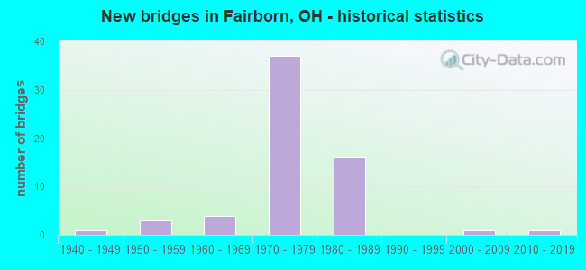
- New bridges - historical statistics
- 11940-1949
- 31950-1959
- 41960-1969
- 371970-1979
- 161980-1989
- 12000-2009
- 12010-2019

- Reconstructed bridges - Historical Statistics
- 21980-1989
- 01990-1999
- 12000-2009
- 12010-2019
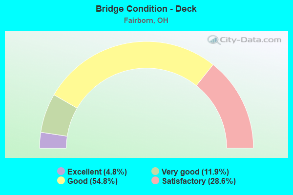
- Bridge Condition - Deck
- 4.8%Excellent
- 11.9%Very good
- 54.8%Good
- 28.6%Satisfactory
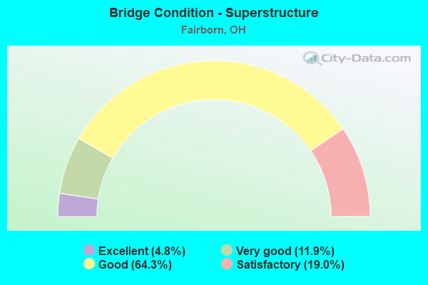
- Bridge Condition - Superstructure
- 4.8%Excellent
- 11.9%Very good
- 64.3%Good
- 19.0%Satisfactory
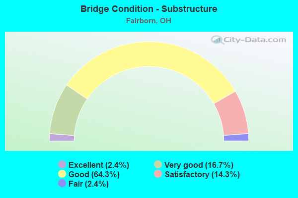
- Bridge Condition - Substructure
- 2.4%Excellent
- 16.7%Very good
- 64.3%Good
- 14.3%Satisfactory
- 2.4%Fair
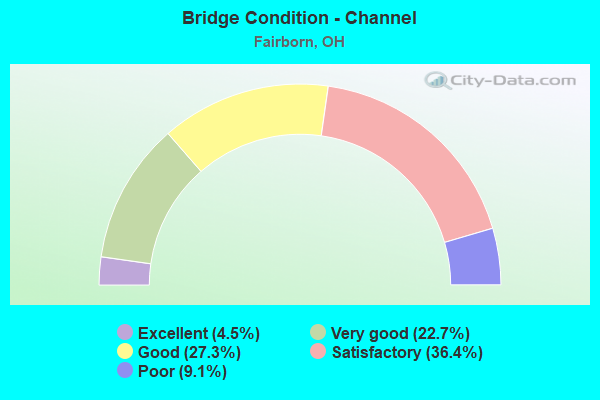
- Bridge Condition - Channel
- 4.5%Excellent
- 22.7%Very good
- 27.3%Good
- 36.4%Satisfactory
- 9.1%Poor
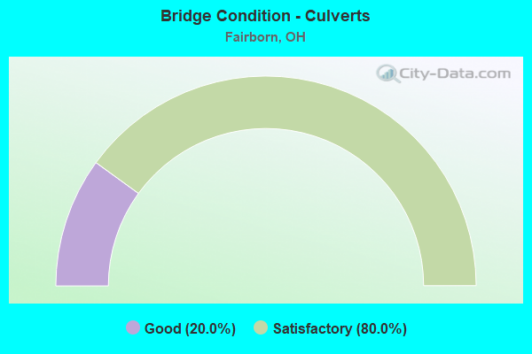
- Bridge Condition - Culverts
- 20.0%Good
- 80.0%Satisfactory
Find on map >> Show street view
Structure Number: 2961008, Location: 0.75 MI S OF JCT SR 235 (Lat: 39.816931, Lng: -84.018461), Route carried "on" structure: County highway 502, Year Built: 1975, Status: Open, Structure Length: 12.86m (42.19ft), Average Daily Traffic: 9,766 (year 2018), Truck Traffic: 10%, Average Future Daily Traffic: 12,770 (year 2038), Design Load: HS 20, Features Intersected: ERIE LACK & PENN CENT RR, Facility Carried by Structure: MAPLE AVENUE
Minimum Vertical Clearance: 30+ m (98+ ft), Kilometerpoint: 2.752, Lanes on structure: 3, Owner: City or Municipal Highway Agency, Approaching Roadway Width: 22.6m (74.1ft), Skew: 4 degrees, Material/Design: Steel continuous, Design/Construction: Stringer/Multi-beam, Number Of Spans In Main Unit: 4, Length of Maximum Span: 44.2m (145.0ft), Curb or Sidewalk Widths: Left: 1.5m (4.9ft), Right: 0.6m (2.0ft), Curb-To-Curb Width: 15.9m (52.2ft), Out-to-Out Width: 18.7m (61.4ft)
Condition: Deck: Good, Superstructure: Good, Substructure: Good, Operating Rating: 25.9 metric tons, Method Used To Determine Operating Rating: Load Factor (LF) rating reported by rating factor (RF) method using MS18 loading, Inventory Rating: 16.2 metric tons, Method Used To Determine Inventory Rating: Load Factor (LF) rating reported by rating factor (RF) method using MS18 loading, Structural Evaluation: Meets minimum limits, Deck Geometry: Better than present minimum criteria, Underclear: Equal to present desirable criteria, Approach Roadway Alignment: Equal to present desirable criteria, Designated Inspection Frequency: Every 24 months, Inspection Date: July 2021, Deck Structure Type: Concrete Cast-file-Place, Wearing Surface/Protective System: Wearing Surface: Monolithic Concrete
Find on map >> Show street view
Structure Number: 2961024, Location: AT DAYTON YELLOW SPRINGS (Lat: 39.783281, Lng: -83.997250), Route carried "on" structure: City street 1066, Year Built: 1986, Status: Open, Structure Length: 0.67m (2.20ft), Average Daily Traffic: 4,455 (year 2018), Truck Traffic: 7%, Average Future Daily Traffic: 6,184 (year 2038), Design Load: HS 20, Features Intersected: TRIB TO BEAVER CREEK, Facility Carried by Structure: COMMERCE CTR BLVD
Minimum Vertical Clearance: 4.88m (16.01ft), Kilometerpoint: 0.016, Lanes on structure: 4, Owner: City or Municipal Highway Agency, Approaching Roadway Width: 18.3m (60.0ft), Material/Design: Concrete, Design/Construction: Culvert, Number Of Spans In Main Unit: 2, Length of Maximum Span: 3.0m (9.8ft), Curb or Sidewalk Widths: Left: 1.5m (4.9ft), Right: 1.5m (4.9ft)
Condition: Channel: Satisfactory, Culverts: Satisfactory, Operating Rating: 51.8 metric tons, Method Used To Determine Operating Rating: Load Factor (LF) rating reported by rating factor (RF) method using MS18 loading, Inventory Rating: 32.4 metric tons, Method Used To Determine Inventory Rating: Load Factor (LF) rating reported by rating factor (RF) method using MS18 loading, Structural Evaluation: Equal to present minimum criteria, Waterway Adequacy: Equal to present desirable criteria, Approach Roadway Alignment: Equal to present desirable criteria, Designated Inspection Frequency: Every 12 months, Inspection Date: July 2021
Find on map >> Show street view
Structure Number: 2961032, Location: AT DAYTON YELLOW SPRINGS (Lat: 39.783850, Lng: -83.993381), Route carried "on" structure: City street 1114, Year Built: 1986, Status: Open, Structure Length: 0.67m (2.20ft), Average Daily Traffic: 4,171 (year 2015), Truck Traffic: 7%, Average Future Daily Traffic: 5,789 (year 2035), Design Load: HS 20, Features Intersected: TRIB TO BEAVER CREEK, Facility Carried by Structure: EXCHANGE COURT
Minimum Vertical Clearance: 30+ m (98+ ft), Kilometerpoint: 0.016, Lanes on structure: 3, Owner: City or Municipal Highway Agency, Approaching Roadway Width: 18.3m (60.0ft), Material/Design: Concrete, Design/Construction: Culvert, Number Of Spans In Main Unit: 2, Length of Maximum Span: 3.0m (9.8ft), Curb or Sidewalk Widths: Left: 0.0m, Right: 1.5m (4.9ft)
Condition: Channel: Satisfactory, Culverts: Satisfactory, Operating Rating: 48.6 metric tons, Method Used To Determine Operating Rating: Load Factor (LF) rating reported by rating factor (RF) method using MS18 loading, Inventory Rating: 29.2 metric tons, Method Used To Determine Inventory Rating: Load Factor (LF) rating reported by rating factor (RF) method using MS18 loading, Structural Evaluation: Equal to present minimum criteria, Waterway Adequacy: Equal to present desirable criteria, Approach Roadway Alignment: Equal to present desirable criteria, Designated Inspection Frequency: Every 12 months, Inspection Date: July 2021
Find on map >> Show street view
Structure Number: 2961202, Location: 325 FT N OF W XENIA DR (Lat: 39.824589, Lng: -84.020689), Route carried "on" structure: County highway 54, Year Built: 1968, Status: Open, Structure Length: 0.64m (2.10ft), Average Daily Traffic: 8,222 (year 2018), Truck Traffic: 2%, Average Future Daily Traffic: 11,243 (year 2038), Design Load: HS 15, Features Intersected: HEBBLE CREEK, Facility Carried by Structure: N CENTRAL AVE
Minimum Vertical Clearance: 4.88m (16.01ft), Kilometerpoint: 1.931, Lanes on structure: 4, Owner: City or Municipal Highway Agency, Approaching Roadway Width: 14.0m (45.9ft), Skew: 1 degrees, Material/Design: Steel, Design/Construction: Culvert, Number Of Spans In Main Unit: 2, Length of Maximum Span: 2.2m (7.2ft), Curb or Sidewalk Widths: Left: 1.5m (4.9ft), Right: 1.5m (4.9ft)
Condition: Channel: Good, Culverts: Satisfactory, Operating Rating: 97.2 metric tons, Method Used To Determine Operating Rating: Load and Resistance Factor Rating (LRFR) rating reported by rating factor(RF) method using HL-93 loadings, Inventory Rating: 81.0 metric tons, Method Used To Determine Inventory Rating: Load and Resistance Factor Rating (LRFR) rating reported by rating factor(RF) method using HL-93 loadings, Structural Evaluation: Equal to present minimum criteria, Waterway Adequacy: Equal to present desirable criteria, Approach Roadway Alignment: Equal to present desirable criteria, Designated Inspection Frequency: Every 12 months, Inspection Date: July 2021
Find on map >> Show street view
Structure Number: 2961237, Location: 125' N OF NEW GERMANY TRE (Lat: 39.768039, Lng: -84.012069), Route carried "on" structure: County highway 8, Year Built: 1989, Status: Open, Structure Length: 0.82m (2.69ft), Average Daily Traffic: 7,049 (year 2018), Truck Traffic: 5%, Average Future Daily Traffic: 9,782 (year 2038), Design Load: HS 20+Mod, Features Intersected: TRIB TO BEAVER CREEK, Facility Carried by Structure: BEAVER VALLEY ROAD
Minimum Vertical Clearance: 30+ m (98+ ft), Kilometerpoint: 0.016, Lanes on structure: 2, Owner: City or Municipal Highway Agency, Approaching Roadway Width: 9.1m (29.9ft), Skew: 1 degrees, Material/Design: Concrete, Design/Construction: Frame, Number Of Spans In Main Unit: 1, Length of Maximum Span: 7.6m (24.9ft), Curb-To-Curb Width: 10.7m (35.1ft), Out-to-Out Width: 10.7m (35.1ft)
Condition: Deck: Satisfactory, Superstructure: Satisfactory, Substructure: Good, Channel: Satisfactory, Operating Rating: 55.1 metric tons, Method Used To Determine Operating Rating: Load Factor (LF) rating reported by rating factor (RF) method using MS18 loading, Inventory Rating: 32.4 metric tons, Method Used To Determine Inventory Rating: Load Factor (LF) rating reported by rating factor (RF) method using MS18 loading, Structural Evaluation: Equal to present minimum criteria, Deck Geometry: Meets minimum limits, Waterway Adequacy: Better than present minimum criteria, Approach Roadway Alignment: Equal to present desirable criteria, Designated Inspection Frequency: Every 12 months, Inspection Date: July 2021, Deck Structure Type: Concrete Cast-file-Place, Wearing Surface/Protective System: Wearing Surface: Bituminous, Membrane: Built-up
Find on map >> Show street view
Structure Number: 2961253, Location: 328 FT N OF W XENIA DR (Lat: 39.826031, Lng: -84.024969), Route carried "on" structure: City street 1394, Year Built: 1985, Status: Open, Structure Length: 0.67m (2.20ft), Average Daily Traffic: 200 (year 1985), Truck Traffic: 5%, Average Future Daily Traffic: 278 (year 2005), Design Load: HS 20, Features Intersected: HEBBLE CREEK, Facility Carried by Structure: THIRD STREET
Minimum Vertical Clearance: 5.49m (18.01ft), Kilometerpoint: 0.032, Lanes on structure: 2, Owner: City or Municipal Highway Agency, Approaching Roadway Width: 7.3m (24.0ft), Skew: 4 degrees, Material/Design: Concrete continuous, Design/Construction: Frame, Number Of Spans In Main Unit: 2, Length of Maximum Span: 2.3m (7.5ft), Curb or Sidewalk Widths: Left: 0.0m, Right: 1.2m (3.9ft), Curb-To-Curb Width: 7.3m (24.0ft), Out-to-Out Width: 27.4m (89.9ft)
Condition: Deck: Satisfactory, Superstructure: Satisfactory, Substructure: Satisfactory, Channel: Satisfactory, Operating Rating: 64.8 metric tons, Method Used To Determine Operating Rating: Load Factor (LF) rating reported by rating factor (RF) method using MS18 loading, Inventory Rating: 38.9 metric tons, Method Used To Determine Inventory Rating: Load Factor (LF) rating reported by rating factor (RF) method using MS18 loading, Structural Evaluation: Equal to present minimum criteria, Deck Geometry: Somewhat better than minimum adequacy, Waterway Adequacy: Equal to present desirable criteria, Approach Roadway Alignment: Equal to present desirable criteria, Designated Inspection Frequency: Every 12 months, Inspection Date: July 2021, Deck Structure Type: Concrete Cast-file-Place, Wearing Surface/Protective System: Wearing Surface: Bituminous
Find on map >> Show street view
Structure Number: 2961288, Location: 150 FT E OF MARCHMONT DR (Lat: 39.805581, Lng: -84.010169), Route carried "on" structure: City street 1139, Year Built: 1980, Status: Open, Structure Length: 0.70m (2.30ft), Average Daily Traffic: 2,624 (year 2018), Truck Traffic: 10%, Average Future Daily Traffic: 3,588 (year 2038), Design Load: HS 20, Features Intersected: BEAVER CREEK, Facility Carried by Structure: GARLAND AVE.
Minimum Vertical Clearance: 30+ m (98+ ft), Kilometerpoint: 0.016, Lanes on structure: 2, Owner: City or Municipal Highway Agency, Approaching Roadway Width: 7.3m (24.0ft), Material/Design: Concrete, Design/Construction: Culvert, Number Of Spans In Main Unit: 2, Length of Maximum Span: 2.7m (8.9ft)
Condition: Channel: Satisfactory, Culverts: Satisfactory, Operating Rating: 97.2 metric tons, Method Used To Determine Operating Rating: Load Factor (LF) rating reported by rating factor (RF) method using MS18 loading, Inventory Rating: 74.5 metric tons, Method Used To Determine Inventory Rating: Load Factor (LF) rating reported by rating factor (RF) method using MS18 loading, Structural Evaluation: Equal to present minimum criteria, Waterway Adequacy: Equal to present desirable criteria, Approach Roadway Alignment: Equal to present desirable criteria, Designated Inspection Frequency: Every 12 months, Inspection Date: July 2021
Find on map >> Show street view
Structure Number: 2961296, Location: 1 MI S OF SR 444 (Lat: 39.830711, Lng: -83.999561), Route carried "on" structure: City street 51, Year Built: 1970, Status: Open, Structure Length: 2.13m (6.99ft), Average Daily Traffic: 1,726 (year 2018), Truck Traffic: 5%, Average Future Daily Traffic: 810 (year 2038), Design Load: HS 20+Mod, Features Intersected: HEBBLE CREEK, Facility Carried by Structure: SPANGLER ROAD
Minimum Vertical Clearance: 30+ m (98+ ft), Kilometerpoint: 0.322, Lanes on structure: 2, Owner: City or Municipal Highway Agency, Approaching Roadway Width: 7.3m (24.0ft), Skew: 1 degrees, Material/Design: Concrete continuous, Design/Construction: Slab, Number Of Spans In Main Unit: 3, Length of Maximum Span: 8.0m (26.2ft), Curb-To-Curb Width: 13.4m (44.0ft), Out-to-Out Width: 13.4m (44.0ft)
Condition: Deck: Satisfactory, Superstructure: Satisfactory, Substructure: Satisfactory, Channel: Satisfactory, Operating Rating: 58.3 metric tons, Method Used To Determine Operating Rating: Load Factor (LF) rating reported by rating factor (RF) method using MS18 loading, Inventory Rating: 35.6 metric tons, Method Used To Determine Inventory Rating: Load Factor (LF) rating reported by rating factor (RF) method using MS18 loading, Structural Evaluation: Equal to present minimum criteria, Deck Geometry: Equal to present desirable criteria, Waterway Adequacy: Equal to present desirable criteria, Approach Roadway Alignment: Equal to present desirable criteria, Designated Inspection Frequency: Every 12 months, Inspection Date: October 2021, Deck Structure Type: Concrete Cast-file-Place, Wearing Surface/Protective System: Wearing Surface: Bituminous
Find on map >> Show street view
Structure Number: 1206508, Location: .79MI.N. OF GREENE CO. (Lat: 39.858269, Lng: -83.994589), Route carried "under" structure: Interstate 675, Year Built: 1975, Structure Length: 0. m, Average Daily Traffic: 45,401 (year 2016), Truck Traffic: 12%, Features Intersected: CR-331 HADDIX ROAD, Facility Carried by Structure: HADDIX RD. CR-331
Minimum Vertical Clearance: 5.87m (19.26ft), Kilometerpoint: 1.271, Lanes on structure: 2, Lanes under structure: 4, Material/Design: Steel continuous, Design/Construction: Stringer/Multi-beam, Length of Maximum Span: 26.2m (86.0ft)
Find on map >> Show street view
Structure Number: 2903954, Location: 1 MI N FAIRBORN S CORP (Lat: 39.783181, Lng: -84.004619), Route carried "under" structure: Interstate 675, Year Built: 1973, Structure Length: 0. m, Average Daily Traffic: 41,057 (year 2015), Truck Traffic: 17%, Features Intersected: DAYTN-YELLOW SPRINGS RD, Facility Carried by Structure: DAY-YELLOW SPRING
Minimum Vertical Clearance: 6.61m (21.69ft), Kilometerpoint: 21.098, Lanes on structure: 5, Lanes under structure: 4, Material/Design: Steel continuous, Design/Construction: Stringer/Multi-beam, Length of Maximum Span: 26.2m (86.0ft)
Find on map >> Show street view
Structure Number: 2904055, Location: .9 MI S OF SR 235 (Lat: 39.803050, Lng: -84.001861), Route carried "under" structure: City street GARLN, Year Built: 1974, Structure Length: 0. m, Average Daily Traffic: 100 (year 1900), Truck Traffic: 99%, Features Intersected: I675*S, Facility Carried by Structure: SB IR 675
Minimum Vertical Clearance: 4.60m (15.09ft), Kilometerpoint: 2.736, Lanes on structure: 2, Lanes under structure: 2, Material/Design: Concrete continuous, Design/Construction: Slab, Length of Maximum Span: 13.1m (43.0ft)
Find on map >> Show street view
Structure Number: 2904063, Location: .9 MI S OF SR 235 (Lat: 39.803031, Lng: -84.001450), Route carried "under" structure: City street GARLN, Year Built: 1974, Structure Length: 0. m, Average Daily Traffic: 100 (year 1900), Truck Traffic: 99%, Features Intersected: I675*N, Facility Carried by Structure: NB IR 675
Minimum Vertical Clearance: 4.62m (15.16ft), Kilometerpoint: 2.768, Lanes on structure: 2, Lanes under structure: 2, Material/Design: Concrete continuous, Design/Construction: Slab, Length of Maximum Span: 13.1m (43.0ft)
Find on map >> Show street view
Structure Number: 2904241, Location: OVER SR 235 (Lat: 39.816281, Lng: -84.000781), Route carried "under" structure: State highway 235, Year Built: 1975, Structure Length: 0. m, Average Daily Traffic: 8,990 (year 2015), Truck Traffic: 7%, Features Intersected: I675*S, Facility Carried by Structure: SB IR 675
Minimum Vertical Clearance: 5.05m (16.57ft), Kilometerpoint: 109.274, Lanes on structure: 2, Lanes under structure: 2, Material/Design: Steel continuous, Design/Construction: Stringer/Multi-beam, Length of Maximum Span: 26.2m (86.0ft)
Find on map >> Show street view
Structure Number: 2904268, Location: OVER SR 235 (Lat: 39.816111, Lng: -84.000381), Route carried "under" structure: State highway 235, Year Built: 1975, Structure Length: 0. m, Average Daily Traffic: 8,990 (year 2015), Truck Traffic: 7%, Features Intersected: I675*N, Facility Carried by Structure: NB IR 675
Minimum Vertical Clearance: 4.60m (15.09ft), Kilometerpoint: 108.953, Lanes on structure: 2, Lanes under structure: 4, Material/Design: Steel continuous, Design/Construction: Stringer/Multi-beam, Length of Maximum Span: 26.2m (86.0ft)
Find on map >> Show street view
Structure Number: 2904292, Location: .6 MI N OF SR 235 (Lat: 39.824911, Lng: -84.000239), Route carried "under" structure: City street YELFF, Year Built: 1975, Structure Length: 0. m, Average Daily Traffic: 13,347 (year 2015), Truck Traffic: 7%, Features Intersected: I675*S, Facility Carried by Structure: SB IR 675
Minimum Vertical Clearance: 4.50m (14.76ft), Kilometerpoint: 1.931, Lanes on structure: 2, Lanes under structure: 2, Material/Design: Steel continuous, Design/Construction: Stringer/Multi-beam, Length of Maximum Span: 15.9m (52.2ft)
Find on map >> Show street view
Structure Number: 2904306, Location: .6 MI N OF SR 235 (Lat: 39.824881, Lng: -83.999850), Route carried "under" structure: City street YELFF, Year Built: 1975, Structure Length: 0. m, Average Daily Traffic: 13,347 (year 2015), Truck Traffic: 7%, Features Intersected: I675*N, Facility Carried by Structure: NB IR 675
Minimum Vertical Clearance: 4.37m (14.34ft), Kilometerpoint: 1.963, Lanes on structure: 2, Lanes under structure: 2, Material/Design: Steel continuous, Design/Construction: Stringer/Multi-beam, Length of Maximum Span: 15.9m (52.2ft)
Find on map >> Show street view
Structure Number: 2904438, Location: OVER SR 444 (Lat: 39.844850, Lng: -83.993531), Route carried "under" structure: State highway 444, Year Built: 1975, Structure Length: 0. m, Average Daily Traffic: 2,905 (year 2015), Truck Traffic: 5%, Features Intersected: I675*S
Minimum Vertical Clearance: 4.88m (16.01ft), Kilometerpoint: 13.189, Lanes on structure: 2, Lanes under structure: 4, Material/Design: Steel continuous, Design/Construction: Stringer/Multi-beam, Length of Maximum Span: 17.4m (57.1ft)
Find on map >> Show street view
Structure Number: 2904446, Location: OVER SR 444 (Lat: 39.844981, Lng: -83.993161), Route carried "under" structure: State highway 444, Year Built: 1975, Structure Length: 0. m, Average Daily Traffic: 2,905 (year 2015), Truck Traffic: 5%, Features Intersected: I675*N, Facility Carried by Structure: IR 675 N
Minimum Vertical Clearance: 4.75m (15.58ft), Kilometerpoint: 13.224, Lanes on structure: 2, Lanes under structure: 4, Material/Design: Steel continuous, Design/Construction: Stringer/Multi-beam, Length of Maximum Span: 14.3m (46.9ft)
Find on map >> Show street view
Structure Number: 2904691, Location: .3 MI S OF SR 444 (Lat: 39.788139, Lng: -84.045639), Route carried "under" structure: County highway WSUNI, Year Built: 1988, Structure Length: 0. m, Average Daily Traffic: 2,000 (year 1900), Truck Traffic: 5%, Features Intersected: SR 844 SB, Facility Carried by Structure: SB SR 444A
Minimum Vertical Clearance: 4.57m (14.99ft), Kilometerpoint: 1.609, Lanes on structure: 3, Lanes under structure: 4, Material/Design: Steel continuous, Design/Construction: Stringer/Multi-beam, Length of Maximum Span: 26.5m (86.9ft)
Find on map >> Show street view
Structure Number: 2904721, Location: .3 MI S OF SR 444 (Lat: 39.788100, Lng: -84.045289), Route carried "under" structure: County highway WSUNI, Year Built: 1988, Structure Length: 0. m, Average Daily Traffic: 2,000 (year 1900), Truck Traffic: 5%, Features Intersected: SR 844 NB, Facility Carried by Structure: NB 444A
Minimum Vertical Clearance: 4.57m (14.99ft), Kilometerpoint: 3.219, Lanes on structure: 2, Lanes under structure: 4, Material/Design: Steel continuous, Design/Construction: Stringer/Multi-beam, Length of Maximum Span: 26.5m (86.9ft)
Find on map >> Show street view
Structure Number: 290481, Location: OVER SR 444 (Lat: 39.792411, Lng: -84.047261), Route carried "under" structure: State highway 444, Year Built: 1988, Structure Length: 0. m, Average Daily Traffic: 13,402 (year 2015), Truck Traffic: 5%, Features Intersected: SR 844 SB
Minimum Vertical Clearance: 6.65m (21.82ft), Kilometerpoint: 42.969, Lanes on structure: 3, Lanes under structure: 4, Material/Design: Steel continuous, Design/Construction: Stringer/Multi-beam, Length of Maximum Span: 36.6m (120.1ft)
Find on map >> Show street view
Structure Number: 290481, Location: OVER SR 444 (Lat: 39.792411, Lng: -84.047261), Route carried "under" structure: County highway 54, Year Built: 1988, Structure Length: 0. m, Features Intersected: SR 844 SB, Facility Carried by Structure: SB SR 444A
Minimum Vertical Clearance: 9.42m (30.91ft), Kilometerpoint: 48.924, Lanes on structure: 3, Lanes under structure: 4, Material/Design: Steel continuous, Design/Construction: Stringer/Multi-beam, Length of Maximum Span: 36.6m (120.1ft)
Find on map >> Show street view
Structure Number: 2904845, Location: OVER SR 444 (Lat: 39.792561, Lng: -84.046969), Route carried "under" structure: State highway 444, Year Built: 1988, Structure Length: 0. m, Average Daily Traffic: 13,402 (year 2015), Truck Traffic: 5%, Features Intersected: SR 844 NB
Minimum Vertical Clearance: 8.18m (26.84ft), Kilometerpoint: 43.291, Lanes on structure: 3, Lanes under structure: 4, Material/Design: Steel continuous, Design/Construction: Stringer/Multi-beam, Length of Maximum Span: 36.6m (120.1ft)
Find on map >> Show street view
Structure Number: 2904845, Location: OVER SR 444 (Lat: 39.792561, Lng: -84.046969), Route carried "under" structure: County highway 54, Year Built: 1988, Structure Length: 0. m, Features Intersected: SR 844 NB, Facility Carried by Structure: NB SR 444A
Minimum Vertical Clearance: 9.42m (30.91ft), Kilometerpoint: 48.924, Lanes on structure: 3, Lanes under structure: 4, Material/Design: Steel continuous, Design/Construction: Stringer/Multi-beam, Length of Maximum Span: 36.6m (120.1ft)